Embed Size (px)
Citation preview

Regional GIS Users Group Meeting
Wednesday, October 31st, 200710:00 AM - 1:00 PM
Amphitheater, C - Level
www.atlantaregional.com/rgug
Cooperative Purchase AgreementSubcommittee
• Held meeting at Gwinnett Co on October 4, 2007. (Gwinnett, Hall, Henry participated)
• Best Example of a cooperative agreement: Centralina Council of Governments (Charlotte)– 11 counties involved– Regional Color Orthophotography– Individual counties decide on some or none of
other products• Impervious surface, footprints, centroids of structures,
edge of pavement, etc.

Specifications
• Based upon county standards– Highest
• 1” = 100’• 2 foot contours• Only for the Imagery
• Individual needs will be handle in the separate contracts

Example Gwinnett County
• Individual contracts for more data– LIDAR
• Flood planes
– Impervious Surface• Create 11 – 12 million in revenue
– DTM– Planemetrics– True Orthophotography

County Estimates
County Area in Square
MilesTotal Cost Per
County Year Purchased Purchase Price Vendors Resolution Scale Format
Barrow 163 $34,556 2004 $105,530 Land Air 6"
Bartow 470 $99,640 2006 $450,000 Photo Science 6" 1" = 600"
Carroll 504 $106,848 2004 Sanborn
Cherokee 434 $92,008 2007 Photo Science 6"
Clayton 144 $30,528 2006 $81,459 Pictometry
Cobb 344 $72,928 N/A
Coweta 446 $94,552 2007 Photo Science 12"
DeKalb 271 $57,452 2007 $12,000 Aerials Express 18"
Douglas 200 $42,400 2007 $55,000 Geodesy 6" 1" = 100' Tiff
Fayette 199 $42,188 2006 $145,000 Land Air 6" 1" = 100' Tiff
Forsyth 247 $52,364 2006 Pictometry 6"
Fulton 535 $113,420 2006 $347,739 Ayres Associates 6"
Hall 429 $90,948 2005 $200,000 Kucera 6"
Gwinnett 437 $92,644 2007 $580,000 Sanborn 6"
Henry 324 $68,688 2007 Photo Science 6"
Newton 279 $59,148 2006 Photo Science 6"
Paulding 315 $66,780 2007 Geodesy 6" 1"=100' GeoTiff
Rockdale 132 $27,984 2007 $7,500 Aerials Express 18"
Spalding 200 $42,400 2005 $78,000 Paragon / Kucera 6" 1"100 TIFF/TFW
Walton 330 $69,960 N/A
Total 6403 $1,357,436
Current Imagery Cooperative Purchase Agreement
Based on Earth Data Quote
Total Cost per square mile is $212 based on 6558 square miles.Total Cost $1,390,296Overage is $32,860 for a total extra cost of $1,643 per countyThis is subject to change.

City Estimates
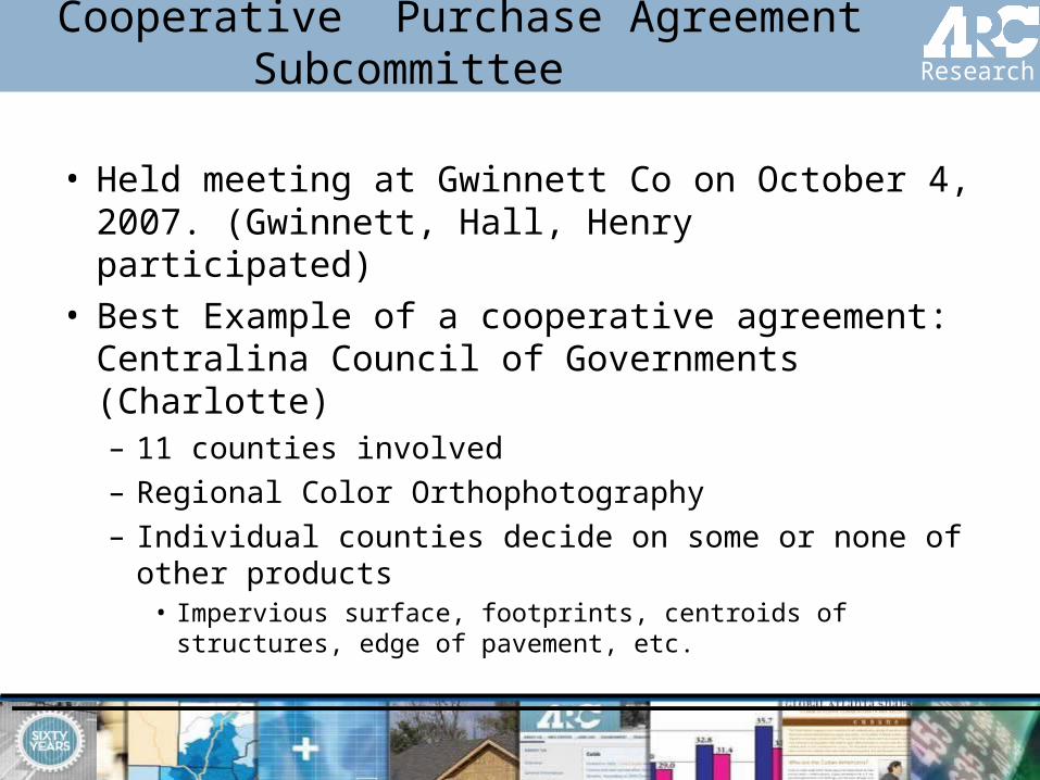
What’s Next
• Reviewed example agreement with Sanborn and Earth Data– “Tentatively” agreed to the general terms- will need to
formalize the agreement
• Prepare RFP to be reviewed by RGUG• Distribute to Counties for verification• Present to ARC Board as a programmatic element for
Calendar year 2009

Aerials Express for 2008

Product Description
• 1.5-foot pixel, color, ortho-rectified• Flown in the 1st quarter of 2008.• Cover approximately 14,000 sq.
miles. • Receive one set of the imagery in
ECW and TIFF/TFW format, projected into State Plane NAD83 Georgia West Feet

Pricing
Number of Agencies
Price Per Agency
1 $17,500
2-3 $15,000
4-5 $12,500
6+ $10,000
Agreements need to be returned by January 15, 2008.

Regional Streets Data Subcommittee
• Held 3 meetings since last RGUG, next meeting November 8th
• Rockdale, Smyrna, ITOS, ARC• Reviewing compatibility of local
government data collection procedures against the GDOT/Federal data standards
• Developing ArcMap tool to facilitate street data generation
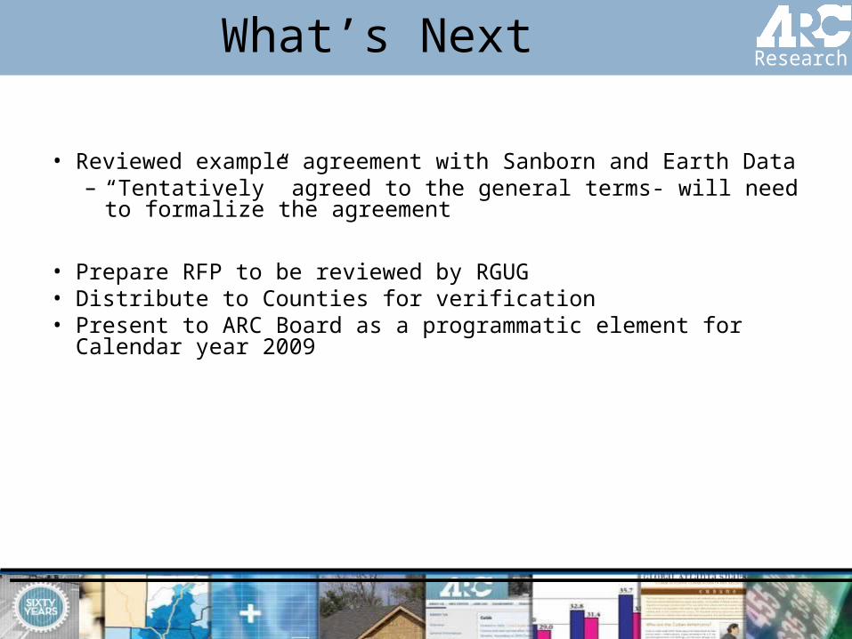
Examples of Data Conflicts
• Address• Road Names• Surface Width• Sidewalks if available• RESOLUTION: prioritized data items,
establishing standards

Regional Streets Data Model Highest Priority Items
• Address• Facility Operation• Length• Road names• Route Number• Route
Type/Jurisdiction• Shoulder Width/
Type
• Speed Limit• Surface Width/ Type• Travel Lanes• Traffic Signals if
available• Sidewalks if
available• Considering Turn
Lanes
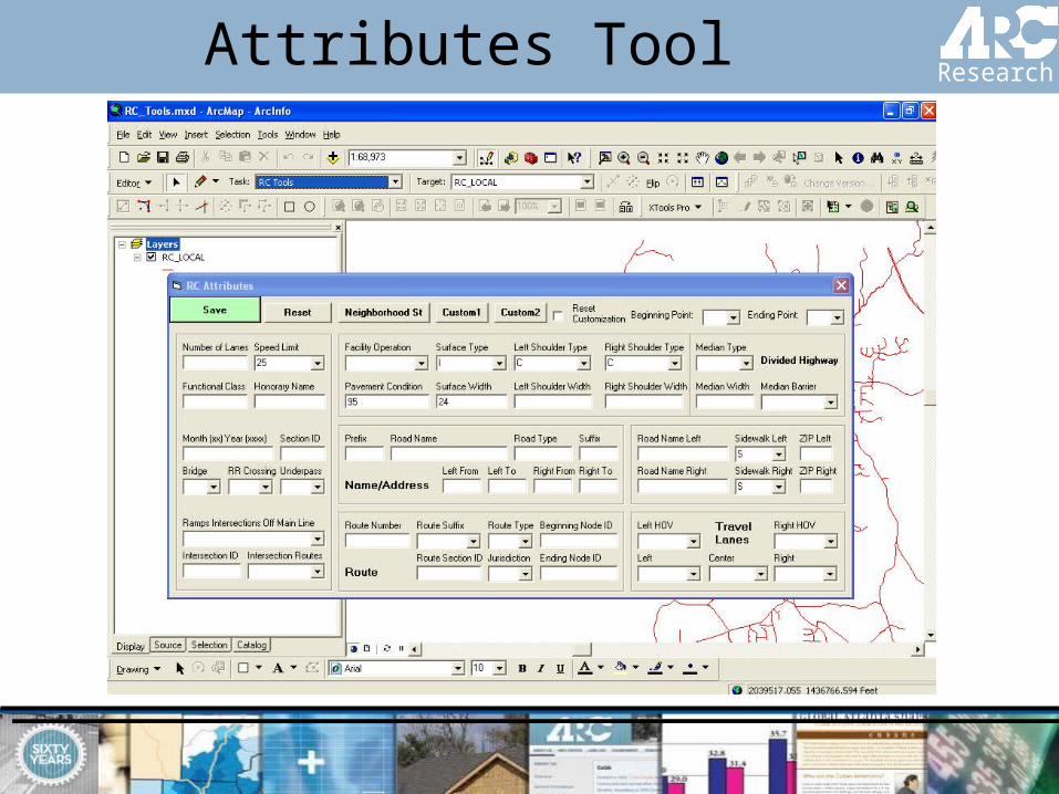
Attributes Tool

Landuse Modeling Program
•20-County model•Landuse forecast•Small area population and
employment forecast•Generate input for Travel
Demand Model

Landuse Modeling Program
• DRAM/EMPAL– Disaggregated Residential Allocation Model
and the EMPloyment Allocation model
• PECAS– Production Exchange Consumption Allocation
System – Activity Allocation (HH and Jobs) Module– Space Development Module
• UrbanSim

Landuse Modeling Program
•Required GIS data:–Households by type–Employment by industry groups–Landuse–Zoning–Housing units and floor space–Price and assessed value…

Landuse Modeling Program
• Parcels – Received
• 16 Counties
– Not received• Carroll and
Paulding
– Line and point parcels
• Clayton and Coweta
• Tax records• Zoning
Hall
Fulton
Carroll
Bartow
Cobb
Coweta
Henry
Gwinnett
Walton
Cherokee
DeKalb
Newton
Paulding
Forsyth
Fayette
Douglas
Spalding
Barrow
Clayton
Rockdale

Hall
Fulton
Carroll
Bartow
Cobb
Coweta
Henry
Gwinnett
Walton
Cherokee
DeKalb
Newton
Paulding
Forsyth
Fayette
Douglas
Spalding
Barrow
Clayton
Rockdale
Landuse Modeling Program
• Building footprint – Received
• DeKalb / Fulton / Gwinnett /Hall
– Not received• Barrow / Bartow
– Under development • Clayton / Rockdale /
Paulding / Henry
– Next step– Future update
• GIS Training at ARC
• Migrating from ArcIMS 9.2 to ArcGIS Server platform• Implement Latitude Geographics Geocortex Essentials
interface for ArcGIS Server• How many are using ArcGIS Server?
• 2005 Pictometry-derived Ortho imagery soon to be released on Georgia GIS Clearinghouse…thanks Carl!
• 2007 Regionwide Pictometry Oblique and Ortho imagery and Electronic Field Study software still available
• 2007 Pictometry mosaicked GeoTIFF Ortho imagery may be available through USGS, pending approval
GIS Training, ArcIMS/ArcGIS Server and 2007
Pictometry

Other Announcements