Embed Size (px)
Citation preview

SOUTH and CENTRAL KALIMANTAN PRODUCTION FOREST PROJECT Jalan A. Yani, No. 37 (km35), Banjarbaru 70711, Indonesia
Tel. (62) 0511 781 975 – 979, Fax: (62) 0511 781 613
EUROPEAN COMMISSION – INDONESIA FOREST PROGRAMME
Forest Protection & Local Development in upper Tabalong
Report No. 107
March 2002

Forest Protection & Local Development in upper TabalongReport No. 107 – March 2002
i
PREFACE The South and Central Kalimantan Production Forest Project (SCKPFP) is a technical co-operation project jointly funded, in terms of the financing memorandum ALA/95/18, by the European Commission and by the Government of the Republic of Indonesia through the Ministry of Forestry and Estate Crops (MoFEC).
This report has been completed in accordance with the project Phase I Overall Work Plan (OWP) and
in part fulfilment of Activity 6.4 , “To recommend any improvement to increase the capacity of forest protection” ,
to achieve Result 6 “The forest ecosystem and associated ecosystems within the project sites managed to maintain viability and diversity”
to realise the three-year project Phase I purpose, which is “SFM model developed that incorporates the ITTO guidelines and principles developed and implemented in the forestry operation of Aya Yayang and a central Kalimantan pilot concession.”
This report has been prepared with financial assistance from the Commission of the European Communities. The opinions, views and recommendations expressed are those of the author(s) and in no way reflect the official opinion of the Commission. The report has been prepared by:
• Junaidi Payne (Ecologist)
The report is acknowledged and approved for circulation by the Project Co-Directors when duly signed below.
Banjarbaru, March 2002
Dr. John Tew International Co-Director
Dr. Silver Hutabarat National Co-Director

Forest Protection & Local Development in upper TabalongReport No. 107 – March 2002
ii
ACKNOWLEDGEMENTS
Thanks go to all those people who, directly or indirectly, provided information and ideas contributing to the formulation of this report.
Front cover :
(top right) Forest clearance for rice planting and land claims in production forest in the PT AYI area – however, HTI, transmigration scehemes and villages are also shown as “production forest” on the current RTRWK for Tabalong, implying that “production forest” can be used by anyone for any purpose.
(above left) Aerial view of extensive idle land between Tanjung and Panaan, a result of past swidden farming without leaving forest cover on ridge tops, and repeated fire. Certainty over land tenure and road access would help to stimulate productive use. Potential uses of alang-alang grassland away from streams would be tree crops and / or non-irrigated rice farming using the traditional “swidden” system with long fallow periods.
(below) Land west of Hapit-Hapit, near Mahe, which was a rubber plantation in colonial times (part of the New Hayup estate, between 1912 and 1930s), later degraded to scrub and alang-alang, and more recently planted with oil palm. This land has a HGK (Hak Guna Usaha) title covering 957 ha, but local people have planted rubber (visible in background) and claim about 360 ha of the titled land.

Forest Protection & Local Development in upper TabalongReport No. 107 – March 2002
iii
EXECUTIVE SUMMARY This report looks at forest protection in the broad socio-economic context, and seeks to identify a strategic approach for forest protection and economic development in the upper Tabalong area.
The report argues that forest protection and economic development in upper Tabalong are closely related, and that neither will be achieved unless steps are initiated to provide security of land tenure.
Attempts to enforce laws will not be effective as long as forest land is regarded as open access. Similarly, attempts to promote investment will not be effective as long as tenure of specific land areas cannot be guaranteed by law and as long as land owners cannot obtain credit by using land as collateral.
Forest protection should not be aimed at only some areas. All forest areas in upper Tabalong are either under threat now, or will be in the future, from illegal logging, ladang making, fire or mining. The issue is now how to retain as much forest as possible and allow it to regenerate in order to fulfill the wider social functions of water protection, supply of non timber forest products, and licensed timber production that can be taxed for public welfare spending by local government, and used for industry and employment.
The greatest single cause of forest loss in upper Tabalong over the period 1982 – 2002 appears to be due to deliberate conversion of natural forest to HTI and transmigrasi schemes, neither of which have succeeded in their aims.
Droughts and fires served to reduce and degrade large areas of what was previously forest land.
The original purpose of non-irrigated rice farming using a forest fallow system (known as swidden farming) was to produce adequate amounts staple food in a sustainable way in situations where prevailing topography, soils and rainfall patterns rendered settled farming and irrigated rice fields either difficult, impossible or unnecessary.
For many people now, production of rice from swidden farms is only one of four potential economic benefits, the others being sale of timber from the site, planting of rubber which may yield latex or wood for sale in the future, and “proof” of “ownership” of the site.
Many thousands of hectares of idle land (which is neither under forest cover nor planted productively) exist between Tanjung town and Panaan, in Kalimantan Selatan (Kabupaten Tabalong) and Kalimantan Tengah (Kabupaten Barito Timur). There are three major problems associated with making idle land productive : road access, water supply and land tenure.
Most people in upper Tabalong are accustomed to the benefits of roads, and road access will always be a key factor in making a decision on their future life. The more that roads can be concentrated in areas most suitable for permanent human

Forest Protection & Local Development in upper TabalongReport No. 107 – March 2002
iv
settlement the better. Similarly, the more roads that exist within forest areas, the more certain it will be that the forest will disappear.
In much of upper Tabalong, the land is probably too high to be able to rely on wells, and small streams dry out during dry periods. The development of communities where a reliable water supply does not exist (e.g. along the road between Kalingai and the PT AYI concession) makes no sense for anyone.
The pattern of settlement and land use which has emerged in upper Tabalong since around 1970 depends too much on maintenance of roads built by PT AYI and HTI management, on transmigration schemes of limited success, and on lack of law enforcement.
The best long term land use away from permanent water courses consists of a combination of forest, commercial scale plantations of robust tree crops for wood and other purposes (e.g. oil palm) and swidden farming for hill rice production.
A very significant underlying reason why economic development in upper Tabalong has stagnated to an unsustainable dependency on never-ending deforestation is the absence of an implemented, legally valid system of rights relating to land use, ownership or transfer.
For farmers and plantation developers, possession of a valid land title represents a means to raise credit or a loan for developing the land productively. A land title also represents assurance that, in the future, the land can be sold at profit, and so the land itself represents an investment as well as a means to generate regular income.
A package of measures is needed to encourage people to settle in areas that will be inhabitable in the long term and introduce the concept that natural forests are no longer open-access resources available to anyone, but state property to be protected and managed for public welfare.
The measures recommended include :

Forest Protection & Local Development in upper TabalongReport No. 107 – March 2002
v
Measure Key points Relevant authorities Revision of RTRW Kabupaten Tabalong
Reflect a practical combination of actual existing land use and an optimum goal for the future
Pemda, BAPPEDA, BIPHUT, Dinas Kehutanan, MoF
Allocate specific areas for swidden farming to those communities which have members who wish to continue non-irrigated rice farming
Allow the community to decide internally how to allocate land and rights for such farming
Pemda, Bupati, BPN, the forestry, land and agriculture authorities, and BAPPEDA
One or two communities already formally recognised by government to be selected as model villages
Official village boundary to be established, which should not overlap with production forest or protection forest, and within which swidden farming will be done
Pemda, Bupati, BPN, the forestry, land, agriculture and community development authorities, and BAPPEDA
HTI boundaries to be revised
Use consultative process with local land claimants, if necessary with cuts in HTI size. Boundaries should be clearly marked with “living fences” of prominent fast-growing trees
Pemda , BPN and the forestry and agricultural authorities
A fresh initiative to help break the current unsustainable scenario
Possible examples : (a) channeling Dana Reboisasi funds to selected communities and locations; (b) seeking foreign funds for HTI; or (c) seeking an outside investor in large scale oil palm plantation for an area, but only where land tenure is secure
Pemda, BPN and the forestry and agricultural authorities
The entire boundary of the southern part of the PT AYI HPH to be demarcated
Plant with a robust “living fence”, such as Acacia mangium trees
PT AYI, in collaboration with Pemda, BPN and the forestry and land authorities
Adoption of a sustainable forest management (SFM) by PT AYI (endorsed by government)
SFM plan to be implemented by PT AYI; dismissal of staff and ejection of staff relatives who are involved in activities relating to illegal logging or farming in forest areas in upper Tabalong
PT AYI, with input from the forestry authorities
Formal system of issuing and registering land rights to be introduced and promoted
Appropriate opportunities should be sought to commence introduction into upper Tabalong
Bupati, BPN

Forest Protection & Local Development in upper TabalongReport No. 107 – March 2002
vi
RINGKASAN (INDONESIAN SUMMARY) Laporan ini menitikberatkan pada upaya perlindungan hutan lebih pada konteks sosial ekonomi, dan mengidentifikasi pendekatan strategis terhadap perlindungan hutan dan pembangunan ekonomi di Hulu Tabalong.
Dalam laporan ini tersurat bahwa perlindungan hutan dan pembangunan ekonomi di Hulu Tabalong sangat terkait erat, dan bahwa takkan satupun dapat dicapai kecuali ada upaya untuk menginisiasi kepastian lahan.
Upaya untuk menegakkan hukum tidak akan efektif selama kawasan hutan merupakan daerah yang memiliki akses terbuka. Demikian pula upaya untuk mempromosikan peluang investasi tidak akan efektif sepanjang kepastian beberapa kawasan/ lahan tertentu tidak terjamin oleh hukum, dan sepanjang para pemiliknya tidak memperoleh kredit yang menggunakan lahan sebagai jaminannya.
Perlindungan hutan tidak ditujukan pada beberapa kawasan saja. Namun semua kawasan hutan di Hulu Tabalong, baik yang sedang terancam saat ini maupun di masa mendatang, dari kegiatan penebangan liar, pembukaan ladang, kebakaran hutan atau pertambangan. Permasalahannya saat ini adalah bagaimana menjaga sebanyak mungkin kawasan hutan, dan membiarkannya beregenerasi dalam memenuhi fungsi-fungsi sosial yang lebih luas terhadap perlindungan air, pasokan HHBK, produksi kayu legal yang dapat menghasilkan pajak bagi pemerintahan daerah untuk kesejahteraan publik, serta dipergunakan untuk industri dan ketenaga kerjaan.
Sebab yang paling utama terhadap kehilangan hutan di Hulu Tabalong selama kurun waktu 1982-2002 tampaknya lebih disebabkan oleh tujuan konversi hutan alam menjadi HTI dan rencana transmigrasi, yang tidak pernah berhasil.
Kekeringan dan kebakaran dapat mengurangi dan menurunkan luas kawasan yang semula merupakan kawasan hutan.
Tujuan utama ladang yang menggunakan sistem pemberaan hutan (kemudian dikenal sebagai ladang berpindah) adalah untuk menghasilkan sejumlah bahan pangan dalam tempo yang cepat dan mencukupi serta berkesinambungan, dalam situasi di mana kondisi topografi yang ada, tanah dan curah hujan, menyebabkan pertanian menetap dan persawahan sangat sulit, tidak mungkin bahkan tidak penting untuk diterapkan.
Bagi sebagian orang saat ini, produksi beras dari ladang berpindah hanya satu dari empat potensi keuntungan ekonomi. Lainnya adalah menjual kayu dari hutan, menanam karet yang menghasilkan latex atau menjual kayunya di masa depan, dan “mengakui kepemilikan” lahan tersebut.
Beribu-ribu hektar lahan tidur (dimana bukan saja di bawah tutupan hutan namun juga yang secara produktif di tanami) terdapat di antara kota Tanjung dan Panaan, di Kalimantan Selatan (Kabupaten Tabalong) dan di Kalimantan Tengah (Kabupaten Barito Timur). Terdapat tiga permasalahan utama yang menyebabkan lahan tidur menjadi tidak produktif: akses jalan, pasokan air, dan kepastian lahan.

Forest Protection & Local Development in upper TabalongReport No. 107 – March 2002
vii
Umumnya masyarakat di Hulu Tabalong memahami manfaat jalan, dan akses jalan akan selalu menjadi faktor kunci dalam membuat keputusan bagi hari depan mereka. Selebihnya bahwa jalan-jalan tersebut dapat dipusatkan dalam kawasan yang sesuai bagi pemukiman tetap yang lebih baik. Demikian pula, jalan-jalan yang terdapat di dalam kawasan hutan, lebih menjamin kehilangan hutan.
Kebanyakan lahan di Hulu Tabalong, kemungkinan terlalu tinggi untuk membuat sumur, serta aliran sungai kecil yang sering mengering selama musim kemarau. Pembangunan masyarakat dimana tidak terdapat pasokan air yang baik (contohnya sepanjang jalan antara Kalingai dan HPH PT AYI) tidak memiliki manfaat sedikitpun kepada setiap orang.
Pemukiman dan pemanfaatan lahan yang terdapat di Hulu Tabalong sejak 1970 sangat bergantung pada pemeliharaan badan jalan yang dilakukan oleh PT AYI dan manajemen HTI, juga pada program transmigrasi yang terbatas keberhasilannya, dan pada kurangnya penegakkan hukum.
Pemanfaatan lahan terbaik untuk jangka panjang bagi daerah yang jauh dari sumber air permanen adalah dengan kombinasi hutan dan penanaman berskala komersial tanaman kayu dan lainnya (misalnya sawit) serta perladangan berpindah untuk produksi padi gunung.
Alasan yang sangat signifikan mengapa pembangunan ekonomi di Hulu Tabalong terhambat pada ketergantungan yang tidak lestari pada deforestasi yang tak berakhir adalah ketiadaan sistem baku yang absah terhadap hak-hak yang terkait dengan pemanfaatan lahan, kepemilikan atau peralihan.
Bagi petani dan pengembang penanaman, pengakuan kepemilikan lahan yang absah memberikan makna untuk memperoleh kredit atau pinjaman untuk mengembangkan lahan yang lebih produktif. Pengakuan lahan juga memberikan makna jaminan bahwa di masa mendatang lahan dapat dijual untuk mendatangkan keuntungan, dan lahan itu sendiri bermakna investasi yang juga berarti meningkatkan pendapatan.
Sejumlah upaya diperlukan untuk memastikan masyarakat tetap tinggal di daerah tersebut yang dapat dihuni dalam jangka waktu lama, serta memperkenalkan konsep-konsep bahwa hutan alam bukan lagi merupakan sumberdaya yang dapat diakses secara terbuka bagi semua orang, tetapi merupakan hak milik negara yang harus dilindungi dan dikelola untuk kesejahteraan umat.
Upaya-upaya ini merekomendasikan:
Forest Protection & Local Development in upper TabalongReport No. 107 – March 2002
viii
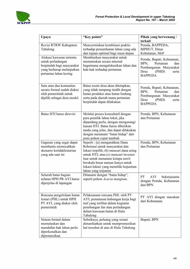
Upaya “Key points” Pihak yang berwenang / terkait
Revisi RTRW Kabupaten Tabalong
Mencerminkan kombinasi praktis terhadap pemanfaatan lahan yang ada dan tujuan optimal bagi masa depan
Pemda, BAPPEDA, BIPHUT, Dinas Kehutanan, MoF
Alokasi kawasan tertentu untuk perladangan berpindah bagi masyarakat yang berharap melanjutkan pertanian lahan kering
Membiarkan masyarakat untuk memutuskan secara internal bagaimana mengalokasikan lahan dan hak-hak terhadap pertanian
Pemda, Bupati, Kehutanan, BPN, Pertanian dan Pembangunan Masyarakat Desa (PMD) serta BAPPEDA
Satu atau dua komunitas secara formal sudah diakui oleh pemerintah untuk dipilih sebagai desa model
Batas resmi desa akan ditetapkan, yang tidak tumpang tindih dengan hutan produksi atau hutan lindung serta pada daerah mana pertanian berpindah dapat dilakukan
Pemda, Bupati, Kehutanan, BPN, Pertanian dan Pembangunan Masyarakat Desa (PMD) serta BAPPEDA
Batas HTI harus direvisi Melalui proses konsultatif dengan
para pemilik lahan lokal, jika dipandang perlu, dengan mengurangi luasan HTI. Batas harus diberikan tanda yang jelas, dan dapat dilakukan dengan menanam “batas hidup” dari jenis pohon cepat tumbuh
Pemda, BPN, Kehutanan dan Pertanian
Gagasan yang segar dapat membantu memecahkan skenario ketidaklestarian yang ada saat ini
Seperti : [a] mengarahkan Dana Reboisasi untuk masyarakat dan lokasi terpilih; (b) mencari dana asing untuk HTI; atau (c) mencari investor luar untuk menanam kelapa sawit berskala besar namun hanya untuk lokasi-lokasi yang memiliki kepastian lahan yang terjamin
Pemda, BPN, Kehutanan dan Pertanian
Seluruh batas bagian selatan HPH PR AYI harus diperjelas di lapangan
Ditanami dengan “batas hidup”, seperti pohon Acacia mangium. PT AYI bekerjasama
dengan Pemda, Kehutanan dan BPN
Rencana pengelolaan hutan lestari (PHL) untuk HPH PT AYI, yang diakui oleh pemerintah
Pelaksanaan rencana PHL oleh PT AYI; pemutusan hubungan kerja bagi staf yang terlibat dalam kegiatan penebangan liar atau perladangan dalam kawasan hutan di Hulu Tabalong
PT AYI dengan masukan dari Kehutanan.
Sistem formal dalam memutuskan dan mendaftar hak lahan perlu diperkenalkan dan dipromosikan
Sebaiknya, peluang yang sesuai dimanfaatkan untuk mempromosikan hal tersebut di atas di Hulu Tabalong
Bupati, BPN

Forest Protection & Local Development in upper TabalongReport No. 107 – March 2002
ix
ABBREVIATIONS AND ACRONYMS AYI PT Aya Yayang Indonesia (project forest concession partner)
BAPPEDA Badan Perencanaan Daerah (=Local Planning Board, can be provincial or district)
BPN Badan Pertanahan Nasional (national land agency)
HPH Hak Pengusahaan Hutan (= Forest Concession Right)
HTI Hutan Tanaman Industri (= Industrial Tree Plantation)
ladang non-irrigated rice farms, usually planted with rubber after one or two harvests
MoF Ministry of Forestry (Kementerian Kehutanan)
PEMDA
RTRWK
RTRWP
Pemerintah Daerah (=Local Government)
Rencana Tata Ruang Wilayah Kabupaten (district land use plan)
Rencana Tata Ruang Wilayah Propinsi (provincial land use plan)
SCKPFP South/Central Kalimantan Production Forest Programme

Forest Protection & Local Development in upper TabalongReport No. 107 – March 2002
x
Table of Contents
PREFACE..................................................................................................................................................................................i ACKNOWLEDGEMENTS......................................................................................................................................................ii EXECUTIVE SUMMARY .....................................................................................................................................................iii RINGKASAN (Indonesian Summary) ....................................................................................................................................vi ABBREVIATIONS AND ACRONYMS................................................................................................................................ix 1 INTRODUCTION............................................................................................................................................1 1.1 Background .....................................................................................................................................................1 1.2 Aims ................................................................................................................................................................1 2 METHODS .......................................................................................................................................................2 3 RESULTS & DISCUSSION............................................................................................................................3 3.1 Which forests need protection in upper Tabalong? .........................................................................................3 3.2 Why forests are unprotected............................................................................................................................3 3.3 Major cause of forest loss................................................................................................................................3 3.4 El Nino related drought and fire......................................................................................................................4 3.5 “Shifting cultivation” ......................................................................................................................................4 3.6 Idle land...........................................................................................................................................................5 3.7 Road access .....................................................................................................................................................5 3.8 Domestic water supply ....................................................................................................................................5 3.9 Roads, water supply and sustainable pattern of land use.................................................................................6 3.10 Land tenure......................................................................................................................................................6 4 CONCLUSIONS ..............................................................................................................................................8 5 RECOMMENDATIONS.................................................................................................................................9 5.1 RTRW (land use plan).....................................................................................................................................9 5.2 “Shifting cultivation” ......................................................................................................................................9 5.3 “Model rural villages”.....................................................................................................................................9 5.4 Resolution of HTI boundaries .......................................................................................................................10 5.5 Seek an “anchor” investor / tenant ................................................................................................................10 5.6 Boundary demarcation of the PT AYI HPH area ..........................................................................................11 5.7 Sustainable forest management by PT AYI ..................................................................................................11 5.8 Introduction of a proper system of registered land titles ...............................................................................11 6 REFERENCES...............................................................................................................................................13
List of Appendices
Appendix 1 Land tenure, forest protection and land development ........................................................................................14

Forest Protection & Local Development in upper TabalongReport No. 107 – March 2002
1
1 INTRODUCTION
1.1 Background
This report refers to the catchment area of the upper Tabalong River in general, including land in Central Kalimantan which encompasses the area between Desa Bentot and Desa Jango towards the Tabalong Kiwa River, as well as parts of rivers which have their headwaters in South Kalimantan, but flow into Central and East Kalimantan.
The rate of removal of timber from the remaining accessible forests of upper Tabalong by illegal operators is well above possible sustainable amounts (Payne 2002). People from communities in Kabupaten Tabalong (South Kalimantan) and Kecamatan Petangkep Tutui (Central Kalimantan) enter freely into the PT AYI forest concession to clear forest for rice farms, and for planting rubber with a view to then claiming ownership of the land (Payne & Subekti, 2000). While the process of determining optimum boundaries for protection forest and production forest in upper Tabalong proceeds through the proper legal and administrative procedures, illegal loggers and farmers enter the area unimpeded to fell timber or farm wherever they wish.
The issue of forest protection in upper Tabalong is now far removed from whether there are adequate laws and how they might be better enforced. The issues of law and enforcement have become uncoupled form reality on the ground.
The prospects for protecting forest in upper Tabalong thus seem bleak unless some fundamental changes are made. Are changes possible and what might they be?
1.2 Aims
This report aims to :
- look at forest protection in the broad socio-economic context of upper Tabalong;
- identify a strategic approach for forest protection and economic development in the upper Tabalong area; and
- propose actions to initiate implementation of a strategy.
Forest Protection & Local Development in upper TabalongReport No. 107 – March 2002
2
2 METHODS Existing laws, regulations and RTRW maps relating to land, forest and rural communities were reviewed.
Notes on field visits to upper Tabalong made by the Ecologist over the period April 1999 – February 2002 were reviewed. These visits covered many parts of the PT AYI forest concession on foot and by ketinting boat, four HTI areas (Aya Yayang Indonesia, Jenggala Semesta, Hutan Sembada and Tricorindo), most roads accessible to four wheel drive vehicle in the upper Tabalong area during 1999-2002, and many villages including Hegarmanah, Dambung Raya (including Missim), Panaan (including Kuari and Kalingai), Amparibura, Bentot, Jango, Mahe, Kumap, Muarauya, Salikong and Santuun.
Notes and minutes of formal and informal meetings, involving SCKPFP, held with relevant authorities and stakeholders during 1999 – 2002, were examined.
Relevant SCKPFP specialist reports were reviewed.
Changes in forest cover over the period pre-1983 (as shown on the 1:50,000 scale topographical maps dated 1984) to year 2001 (satellite imagery) were compared.

Forest Protection & Local Development in upper TabalongReport No. 107 – March 2002
3
3 RESULTS & DISCUSSION
3.1 Which forests need protection in upper Tabalong?
Result All forest areas are either under threat now, or will be in the future, from illegal logging, ladang making, fire or mining. There is little point in trying to protect some areas (such as accessible “protection forests” which are mostly devoid of forest cover) but ignoring others (such as production forests accessible by road).
Discussion Whether a particular forest area is classified as protection, production or limited production, and whether it is within a current HPH area or not, are no longer significant issues in relation to forest protection. The issue is now how to retain as much as possible of any remaining natural forest, whatever its condition, and allow it to regenerate in order to fulfill the wider social functions of water protection, supply of non timber forest products, and licensed timber production that can be taxed for public welfare spending by local government.
3.2 Why forests are unprotected
Result Apart from lack of law enforcement, the following represent the main reasons why forests are not being protected in upper Tabalong : (1) a long history of local society in general treating all natural forest as an open access resource (Appendix 1), (2) an unchallenged view held by almost all sectors of society that whoever clears any forest and plants the cleared land, owns that land, (3) a narrow economic base in Tabalong district rooted in a history of timber, rubber and fossil fuels (formerly mainly petroleum, now coal) and, accordingly, limited money-earning opportunities, especially for young men, (4) widespread disbelief amongst local residents of the sincerity or ability of PT. AYI to carry out sustainable forest management (based on performance since 1974), (5) existence of a well-established chain of persons in South Kalimantan running the trade in timber obtained illegally from upper Tabalong, and (6) a low profile approach by government (e.g. few notice boards or briefings, no warnings to ladang makers in production forest).
Discussion All “state forest land” must have a properly demarcated and recorded boundary, and the forest land should be regarded as a “reserve”, to be managed by government for the benefit of the people in general, and not available for private ownership. This concept is currently not understood by most people in Tabalong, including many government staff, some of who speak loosely of “the Aya Yayang forest” as if the forest owned by a company and as if the land is available to anyone else.
3.3 Major cause of forest loss
Result There are clearly many causes of forest loss in upper Tabalong. However, based on inspection of the 1983 topographical maps and year 2000 satellite imagery, the greatest single cause of forest loss in upper Tabalong over the period 1982 – 2002 appears to be due to deliberate conversion of natural forest to HTI and transmigrasi schemes (Maps 1 & 2). Unfortunately, the original aims of (a)

Forest Protection & Local Development in upper TabalongReport No. 107 – March 2002
4
developing large areas of industrial wood production and (b) providing permanent resettlement of poor families have not succeeded.
Discussion Viewed from the local perspective, the whole process has served to show that government and PT AYI have been allowed to destroy large forest areas (perhaps 30,000 hectares) in a way that provided and continues to provide very little benefit to local communities.
3.4 El Nino related drought and fire
Result Although satellite imagery was not available for the period 1982 (the first major El Nino fire period) to 1997 (the second major El Nino fire period), it is clear that these droughts and fires served to reduce and degrade large areas of what was previously forest land as well as some HTI land and farms. The extent of major fire damage to forest seems to be related very closely to a combination of intensive human presence and forest condition at the time of the fire. For example, according to local informants, an old road west of the Kumap river was re-opened and re-logged in 1997, just prior to the main El Nino fires, and this road helped to spread fire from the Kumap settlement far up the Kumap valley into the PT AYI area, seriously degrading much regenerating forest in the eastern part of the concession. Roads facilitated spread of fire in some places, but not all. The forest along the PT AYI road north of km 54 escaped serious fire, and the roadless limestone hills along the Ayu River suffered serious fire. There are numerous signs of localised fires in parts of the PT AYI concession, presumably due to careless use of cigarettes and camp fires.
Discussion Tall regenerating forest far from roads and human communities have the best prospects of surviving drought and fire. Degraded forest near to roads and many people are at high risk of damage from fire during El Nino periods. Other factors being equal, vegetation on limestone is the most susceptible to fire.
3.5 “Shifting cultivation”
Result The original purpose of non-irrigated rice farming using a forest fallow system (known as swidden farming) was to produce adequate amounts staple food in a sustainable way in situations where prevailing topography, soils and rainfall patterns rendered settled farming and irrigated rice fields either difficult, impossible or unnecessary.
Many families in the area between Tanjung and PT AYI concession continue with swidden cultivation of rice in ways that have no or minimal implications on forest protection. Felling rubber gardens to plant non-irrigated rice is surprisingly often seen, the rubber having served as a sign of land ownership and the wood used or sold for firewood or other purposes. Although weeding of non-irrigated rice on former alang-alang and scrub land is onerous, this is also quite commonly seen in Kabupaten Tabalong.
However, for many people and in many localities, the nature of non-irrigated rice farming has changed in upper Tabalong to something different. Now, the main features of hill rice farming are : (a) anyone can try it wherever they wish as long as the current vegetation is forest (i.e. where there is no pre-existing land claim),
Forest Protection & Local Development in upper TabalongReport No. 107 – March 2002
5
(b) the key determinant of choice of site is proximity to a road, so that they can access the site on a motor vehicle, and (c) production of rice is only one of four potential economic benefits, the others being sale of timber from the site, planting of rubber which may yield latex or wood for sale in the future, and “proof” of “ownership” of the site.
The general concensus locally now appears to be that nothing can be done to stop this trend, and some government officials appear to support the trend of local people entering and clearing natural forest, on the grounds that they have no alternative and that rubber is a tree crop.
Discussion“Shifting cultivation” is seen as such an intractable problem that the tendency seems to be towards ignoring it or accepting it. But “shifting cultivation” has to be addressed, otherwise (a) the families practising it will continue to be poor and (b) most of upper Tabalong is at risk of becoming abandoned rubber planting and scrub.
3.6 Idle land
Result Idle land refers to land which is neither under forest cover nor farmed productively, and is typically covered in scrub and grassland, with some untended rubber and fruits trees, too far from a road to be harvested. There are large areas of idle land between Tanjung town and Panaan. If the area between the villages of Siong, Salikung, Solan, Santuun, Hapi Hapit and Bentot are considered (Map 1), there are many thousands of hectares of totally unproductive land and tens of thousands of hectares of under-utilised land, in both South and Central Klaimantan. Much of this land may be within areas allocated to HTI and most is probably claimed by someone, on the grounds that they or their ancestors once farmed there. Nevertheless, all this land is unproductive or under-productive and is likely to remain so unless new initiatives are taken to utilise it.
Discussion There are three major problems associated with making idle land productive : road access (3.7), water supply (3.8, 3.9) and land tenure (3.10).
3.7 Road access
Result As time goes on, fewer families will be willing to exist as subsistence farmers. Most people in upper Tabalong are accustomed to the benefits of roads, and road access will always be a key factor in making a decision on their future life.
Discussion The more that roads can be concentrated in areas most suitable for permanent human settlement the better. Similarly, the more roads that exist within forest areas, the more certain it will be that the forest will disappear.
3.8 Domestic water supply
Result Until the building of roads in the hills of upper Tabalong by logging companies, all communities lived near rivers or permanent streams. Now, if there is no stream or spring nearby, people are willing to settle along roads and bring in water on motor vehicles, or travel by road to water sources. In much of upper

Forest Protection & Local Development in upper TabalongReport No. 107 – March 2002
6
Tabalong, the land is probably too high to be able to rely on wells, and small streams dry out during dry periods.
Discussion A reliable water source for domestic use is essential to permanent human settlement. There are no prospects for a piped water supply along all roads and to all communities in upper Tabalong. The development of communities where a reliable water supply does not exist (e.g. along the road between Kalingai and the PT AYI concession) makes no sense for anyone.
3.9 Roads, water supply and sustainable pattern of land use
Result The pattern of settlement and land use which has emerged in upper Tabalong since around 1970 depends too much on maintenance of roads built by PT AYI and HTI management, on transmigration schemes of limited success, and on lack of law enforcement.
Discussion In view of the need for a reliable domestic water supply, which may not exist over much of the land arrea in upper Tabalong, and the fact that soils away from alluvial riversides are marginal or impossible for intensive farming, the best long term land use in upper Tabalong away from permanent water courses consists of a planned combination of (a) protection forest, (b) production forest, (c) industrial tree plantations for wood production, (d) commercial scale plantations of robust tree crops (e.g. oil palm) and (e) traditional swidden farming for hill rice production with a fallow system involving either natural regrowth or planted timber trees.
3.10 Land tenure
Result There are two main sorts of system relating to land rights operating in upper Tabalong. One is that anyone who plants crops, notably rubber and fruit trees, is recognised by other residents of the area to be the owner of that land and its crop plants. This is rooted in the traditional adat system of recognising land ownership, but has no validity in Indonesian law, and is increasingly unsatisfactory as waves of immigrants have entered the area and some original families left and settled elsewhere. No written records are involved. The system served people well in the past, but will not serve them well in the future. The other system is that of “certificates” which are issued by local community leaders to known local residents, stating that they own or have rights to certain land areas. This system is no more satisfactory than the unwritten adat-based system because (a) it is not valid under Indonesian law, (2) the “certificate” is not held by any permanent centralised authority and may be either lost or forged, (3) the system is open to abuse by patronage of favoured individuals, and (4) the certificate is not recognised by banks or other financial institutions so cannot be used to raise credit.
Discussion In practice, no-one living in upper Tabalong has secure tenure over the land that they occupy or farm (Appendix 1).
A very significant underlying reason why economic development in upper Tabalong has stagnated to an unsustainable dependency on never-ending deforestation is the absence of an implemented, legally valid system of rights relating to land use, ownership or transfer (Appendix 1).

Forest Protection & Local Development in upper TabalongReport No. 107 – March 2002
7
For farmers and plantation developers, possession of a valid land title represents a means to raise credit or a loan for developing the land productively. A land title also represents assurance that, in the future, the land can be sold at profit, and so the land itself represents an investment as well as a means to generate regular income.
The land title might be in perpetuity or for a specified period, with an option to extend. It does not matter which, as long as (a) the boundary is accurately mapped, with permanent boundary markers in the ground and the map accurately reflects that boundary on the ground, (b) the period of the title is at least several tens of years, (c) the title is issued according to the provisions of a law and (d) the title is registered with a proper government authority.

Forest Protection & Local Development in upper TabalongReport No. 107 – March 2002
8
4 CONCLUSIONS Forest protection and economic development in upper Tabalong can be viewed as two sides of the same coin. Neither will be solved independently. Forest protection will not come about merely by hoping for law enforcement (although that would go a long way to helping save forests). Economic development will not happen merely by hoping for more investment.
A major root cause of failure in both areas (forest protection and economic development) is the lack of security over land tenure. No-one, whether a small-scale farmer, plantation developer or government agency will bother to invest time and money in protecting, developing or maintaining a particular land area, whatever the vegetation type, if they have no guaranteed security of tenure over the land.
A package of measures is needed to encourage people to (a) settle in areas that will be inhabitable in the long term (i.e. with fertile soils, road access and water supply) and (b) introduce the concept that natural forests are no longer open-access resources available to anyone, but state property to be protected and managed for public welfare. However, swidden farming to produce rice cannot be ignored or unreasonably discouraged, because many families wish to continue this system for cultural as well as practical economic reasons. Yet again, the solution has to be through identifying specific areas and granting appropriate land rights to rice farming communities.

Forest Protection & Local Development in upper TabalongReport No. 107 – March 2002
9
5 RECOMMENDATIONS All the following recommendations involve working towards a secure land tenure system and more stable pattern of land use throughout upper Tabalong. All of them share the same goal, and any of them can be initiated any time, in whatever way may be deemed appropriate for local conditions. Implementation of just some of them will be beneficial. These points represent the “why”, “where” and “when” of the recommendations.
5.1 RTRW (land use plan)
What? The RTRW for Kabupaten Tabalong should be revised to reflect a practical combination of actual existing land use and an optimum goal for the future. Well-established realities such as villages on productive soils with road access and HTI should be mapped as such, and not as “production forest”, as appears on the current RTRW.
How & who? The process should be led by the relevant authorities including Pemda, BAPPEDA, BIPHUT, Dinas Kehutanan and Ministry of Forestry. SCKPFP should be willing to provide technical assistance if requested.
5.2 “Shifting cultivation”
What? There is endless debate over “shifting cultivation”. A key problem is that it is illegal in production and protection forests, and does not fit into the common government concept of villages and settled farming. Everyone agrees that no law or policy will halt “shifting cultivation” during this generation or next (although it may decline naturally as younger people leave rural communities). The solution, therefore, is to allocate specific areas for swidden farming to those communities which have members who wish to continue non-irrigated rice farming, and allow the community to decide internally how to allocate land and rights for such farming.
How & who? First, the concept requires endorsement by Pemda that it can be implemented within the Kabupaten. Then, the process should be led by the Bupati, with particular input from the forestry, land and agriculture authorities and BAPPEDA. SCKPFP should be willing to provide assistance in facilitating the process if requested. The concept could be introduced in the framework of “model rural villages” (5.3).
5.3 “Model rural villages”
What? One or two communities already formally recognised by government should be selected as model villages with the following features and goals :
- the village(s) should be well-established and on relatively fertile soils with reliable water supplies, and good prospects for rebuilding and maintaining abandoned access roads, in order to provide a sound basis for long-term

Forest Protection & Local Development in upper TabalongReport No. 107 – March 2002
10
sustainability of diverse agricultural production for commercial sale (Salikong and Dambung Raya would be suitable candidates)
- to formally establish an official village boundary, which should not overlap with production forest or protection forest;
- to permit non-irrigated rice farming within, but not outside the village boundary, with protocols and rules for this swidden farming to be developed and agreed within that community;
- if appropriate, to reach an agreement between the community and government over what rights, if any, the community shall have over harvesting of forest products from adjacent production forest, for sale.
How & who? The original idea for a “model village” in upper Tabalong was proposed by Bupati Tablong to SCKPFP at an informal meeting (31 July 2001). The process should be led by Pemda Tabalong, with particular input from BAPPEDA and the forestry, agricultural, land and community development & welfare authorities. SCKPFP should be willing to provide technical assistance if requested.
5.4 Resolution of HTI boundaries
What? As long as the boundaries of HTI Aya Yayang Indonesia (=HTI Murni), HTI Jenggala Semesta, HTI Hutan Sembada and HTI Tricorindo remain uncertain, then farmers will continue to encroach and claim land, and the investors and managers will continue to have little incentive to plant and maintain trees to harvestable size. The HTI boundaries must be revised, through a consultative process with local land claimants, if necessary with cuts in size. Boundaries should be clearly marked, and this could be done with “living fences” of prominent fats-growing trees. In the opinion of the SCKPFP Ecologist, while planting trees for wood production should remain a priority in HTI, the opportunity should be granted to plant other crops (such as oil palm) if it can be demonstrated that such other crops are needed to develop a financially viable plan.
How & who? The process should be led by Pemda, with particular input from the forestry and agricultural authorities. SCKPFP should be willing to provide technical assistance. The relevant local governments must be bold in asserting and supporting the boundaries once they have been agreed.
5.5 Seek an “anchor” investor / tenant
What? There are currently limited options for new economic development in upper Tabalong other than forestry, agriculture and mining. However, some form of fresh initiative would be beneficial in helping to break from the current unsustainable scenario of illegal logging, forest encroachment and subsistence farming, which will ultimately result in no forest and yet more subsistence farmers.
Possible options might include (a) channelling Dana Reboisasi funds to selected communities and locations where land tenure is secure (e.g. a model village; section 5.2); (b) seeking foreign funds for HTI where land tenure is secure; or

Forest Protection & Local Development in upper TabalongReport No. 107 – March 2002
11
(c) seeking an outside investor in large scale oil palm plantation for an area where land tenure is secure.
How & who? The process should be led by Pemda, with particular input from the forestry and agricultural authorities. Pemda must be willing to assert and support security of land tenure for the chosen areas, once they have been agreed. SCKPFP may be able to assist in identifying potential investors or sources of funds.
5.6 Boundary demarcation of the PT AYI HPH area
What? Whether or not the reason given is always genuine, people involved in ladang making frequently state that they do not know the location of the PT AYI HPH boundary. Indeed, the boundary of the PT AYI HPH is either unclear or will eventually become unclear in many places. The entire boundary of the southern part of the HPH should be cut and planted with a robust “living fence”, such as Acacia mangium trees.
How & who? The onus is on PT AYI, but the work should be done in collaboration with Pemda and the forestry and land authorities in order to identify and resolve disputed sites. SCKPFP could potentially assist in conflict resolution.
5.7 Sustainable forest management by PT AYI
What? PT AYI has to demonstrate to all local stakeholders that it is serious about trying to manage its HPH for the main purpose of a sustainable annual cut of commercial timber.
This must be done via at least the following measures :
- development of a sustainable forest management (SFM) plan that is endorsed by government;
- implementation of a SFM plan that is endorsed by government; and
- dismissal of staff and ejection of staff relatives who are involved in activities relating to illegal logging or farming in forest areas in upper Tabalong.
How & who? The onus is on PT AYI, although some allowance must be made for absence of law enforcement by government within the HPH area. Assistance in development and implementation of the SFM plan represents a key aim of SCKPFP.
5.8 Introduction of a proper system of registered land titles
What? Introduction of the formal system of issuing and registering land rights to rural farmers in Kalimantan, according to the provisions of the Basic Agrarian Law (5/1960), cannot be done quickly, or necessarily in any planned or organized manner. However, it needs to be introduced and promoted at some time, otherwise rural people will remain as subsistence farmers with no valid land rights.

Forest Protection & Local Development in upper TabalongReport No. 107 – March 2002
12
It would be beneficial if the Basic Agrarian Law can be revised to address its weaknesses (see Appendix 1).
How & who? Appropriate opportunities should be sought to commence introduction into upper Tabalong of the concept of properly registered land titles and land demarcation. The Bupati and BPN will need to take lead roles.

Forest Protection & Local Development in upper TabalongReport No. 107 – March 2002
13
6 References Payne, J 2002 Amounts, impacts & implications of illegal timber removal from the PT.
AYI forest concession, 1999-2002. Forest Management, Industry & Economics and Environmental Working Paper No.1.
Payne, J & Subekti, A 2000 Inventory of year 2000 ladang incursion along the main road of PT Aya Yayang Indonesia production forest concession. Environmental Working Paper No.15.

Forest Protection & Local Development in upper TabalongReport No. 107 – March 2002
14
Appendix 1
Land tenure, forest protection and land development
Forest Protection & Local Development in upper TabalongReport No. 107 – March 2002
15
Land tenure, forest protection and land development Why is forest disappearing in upper Tabalong, and why is there no progress in economic development for local people? Essentially, because the forests are supposed to be held in trust by the state for the benefit of the people in general, through management for protective purposes and for production of timber and other resources. Instead, this is interpreted as “forests are open access”, which will inevitably lead eventually to degradation and loss of all forests.
Why does robbery and burglary occur? Essentially, because something owned by someone is taken by someone else who expects that he can “get away with it”.
With this sort of theft, almost everyone would say that it is inherently wrong and that effort must be devoted to reduce or stop it. Not so many people agree completely, however, that illegal logging and farming in state forests is wrong. Those who do agree may be concerned more with possible links with landslides, water quality and floods.
The difference between the two scenarios lies in property rights. No-one invested time, money and care into making and maintaining forests and trees. At least one person invested all those things in making a home or acquiring property.
Common recognition and protection of property rights, by government, organisations and individuals, is essential to developing and maintaining both a functioning society and an economy with potential to expand and diversify. Currently, in upper Tabalong there appears to be widespread agreement that property rights are held over (for example) rubber trees and the land on which they are planted, by the person who planted the trees, even though there is no basis for this under Indonesian law, and no register of the planter, planting or land location. On the other hand, it appears that forest and the land on which it is situated are widely regarded as an open access resource. These statements are based on many conversations with local residents, and meetings involving government agencies (notably a meeting on solving the issue of ladangs in the PT AYI concession, Tanjung, 22 August 2001).
Outside the more densely populated areas in Kalimantan, there is no commonly agreed system for land and forest tenure. The Basic Agrarian Law (5/1960) has not been utilised to establish the legal status of the majority of land in Kalimantan. This Law does not allow for the reservation of specific forest land areas for permanent forestry or conservation purposes. This omission can be used to argue that all forest land is potentially available for rural people to use, and the term “use” can be interpreted as non-irrigated rice farming. Traditional Kalimantan farming involving land under fallow, which has probably operated well for a few thousand years, yet this is not addressed specifically in this Law; and no specific means are provided to determine what is “adat” land. Right of land ownership is allowed for rural farmers (Part III), but by a tradition which has evolved since 1960, this seems to be considered appropriate only if a person has remained on a specific plot for more than 20 years. Companies are allowed a “right of use” lease of up to 35 years, but this is equivalent to perhaps less than two crop rotations
It is the absence of a legally valid and commonly agreed system for deciding, defining, demarcating or recording land rights which represents perhaps the most fundamental reason why forest degradation and loss occurs, and why rural farming lacks investment and is unsustainable (see diagram, next page).

Forest Protection & Local Development in upper TabalongReport No. 107 – March 2002
16
WHY THE ABSENCE OF AN AGREED & LEGALLY VALID LAND TENURE SYSTEM HELPS TO SUSTAIN DEFORESTATION & POVERTY OF RURAL FARMERS IN KALIMANTAN
Economic diversification remains minimal
Rural farmers continue making new plots in forest & remain at subsistence level
Illegal logging continues & is not regarded as illegal by rural people
Large plantations not viable
Industrial tree plantations not maintained & subsistence farmers continue to encroach
Idle land remains wide- spread
No investment in large-scale plantations in areas where rural farmers exist
Local : rural communities adopt a system of land rights which has no basis in law & does not include reliable registration
National : Basic Agrarian Law vague on forest land, reserving land for forestry purposes, community and adat land
Province/Kabupaten : RTRW maps indicate approved land use approximately, & at 1:100,000 scale. Precise extent of intended land use at better scale does not exist.
No commonly agreed & legally valid system for deciding, defining, demarcating & recording land rights
Village residents unwilling to invest in activities that require all weather road access
No incentive to invest in building roads to rural villages
Rural village boundaries remain uncertain & not marked
Legal status of land supporting rural communities is unresolved
Rural farmers prefer clearing many separate forest areas as a sign of ownership (dubious claims over many plots is equivalent to certain ownership of one plot)
Natural forest in weak position (forest easily converted, but non-forest cannot be converted back to forest
Everyone argues for their interests amid legal uncertainty
No concept of “forest reserves” owned by the State for public welfare & tax revenue
Government forestry agencies have unclear authority & low incentive to protect specific areas
Lack of land title prevents farmers from obtaining credit or loans
No means or incentive to intensify use of one plot
Government in weak position to determine & protect forests
Trees felled and forest cleared by local residents & migrants
Debate over adat rights to forest land remains unresolved
Adat land cannot be defined
Natural forest regarded as open access by rural people