Embed Size (px)
Citation preview

Report of the SRNWP Lead Centre on
Surface Processes
José A. García-Moya (on behalf of Ernesto Rodríguez & Stefan
Gollvik)
SMNT – INM & SMHI27th EWGLAM & 12th SRNWP Meetings
Ljubljana, October 2005

October 2005 27th EWGLAM & 12th SRNWP Meetings
2
Outline
4th Workshop on Surface issues: main conclusions
Activities at different centres Recent comparison and evaluation
exercises Main fields of activity for the near
future

October 2005 27th EWGLAM & 12th SRNWP Meetings
3
4th SRNWP/HIRLAM workshop on surface processes and assimilation (15-17 Sept 2004, SMHI)
The importing option from global models is not a viable solution for surface variables with model transferability problems (eg soil moisture). It is required a synchronous development of land surface models in both LAM and global models.
Assimilation of ice-free ocean SST. The main requirement of this variable is resolution. GODAE (Global Ocean Data Assimilation Experiment) has the mandate to supply high temporal and spatial resolution using visible and microwave sensors. It is recommended to participate in GODAE meetings and to follow data availability.
Assimilation of sea ice. Some SSM/I products, such as the NCEP gridded version, do not have the required resolution and suffer from coastline problems (land contamination). Use of ocean SAF products is encouraged (and feedback to the SAF). In case of incompatibility between SST and sea ice, the ice cover product should prevail over the SST product. Large gradients of SST at the ice edge might be an issue in (small) geographical areas.
Assimilation of lake temperature and ice cover. It is very relevant to Northern countries. Current methods of initialization based on pseudo-climatology are very crude. Dedicated retrieval of lake temperature based on AVHRR and/or AATSR is possible. Some issues flagged are: (a) atmospheric absorption over mountain areas will require algorithm modifications; (b) bulk versus skin and calibration with in situ data; (c) resolution is probably adequate.
Assimilation of soil temperature. The currently used simple methods are probably adequate. Layers with daily time scales need to be initialised. The degree of coupling of soil temperature increments to those of the surface air temperature should decrease with depth.

October 2005 27th EWGLAM & 12th SRNWP Meetings
4
Assimilation of snow mass.Although snow cover is the most reliable information, it still carries ambiguity. The NOASS/NESDIS cover product is the only timely one. Use of MODIS for independent validation is encouraged. Snow depth observations, to be used with a realistic density, are still essential for the analysis. Analysis of snow depth based on OI should be implemented as soon as possible due to its superiority over the successive corrections option. Special attention should be paid to observation practices and SYNOP (lack of) conventions.
Assimilation of soil moisture. The current magnitude of increments is unrealistic large in many implementations and hampers model development. Variational methods are a step in the right direction: (a) increments are several times smaller; (b) flexible introduction of new observations. The current size of perturbations (for gradient estimations) should be revised. The long term goal should be to further reduce the increments, while still controlling model drifts. Monitoring (weekly?) of accumulated model increments side-by-side with precipitation is encouraged. In the longer term, soil moisture assimilation systems should make use of IR brightness temperature heating rates and/or microwave (passive and active C-, L-band) observations.
Physiographic databases.The move to ECOCLIMAP should be encouraged. There is nothing comparable to ECOCLIMAP for NWP purpose. Albedo can be taken from other sources (eg LandSAF).
Code externalization.Code externalization is the creation of a dedicated, portable library, including all surface related routines and allowing for all needed functionalities of the surface code. It should be considered if usage off-line versions of the code (eg forcing with observed precipitation such as NIMROD) become a significant activity. The coupling algorithm developed by Best et al . (2004) is recommended.

October 2005 27th EWGLAM & 12th SRNWP Meetings
5
The need of a realistic modelled soil moisture should be pursued by improving both model and assimilation formulations. It is recommended the evaluation of surface schemes driven by observations paying special attention to the water budget. The current ISBA surface scheme with only two layers for describing soil moisture evolution hinders a realistic representation of this variable.
Improvement of snow formulation.The current simple description of snow covered surfaces should be upgraded with more physical schemes implying the introduction of predictive equations for additional variables, eg snow albedo, snow density, liquid water retained by the snow package, etc
Challenges in the fine-scale (non-hydrostatic) domain. Surface parameterizations within the kilometre-scale range need deep revision. Equilibrium assumption between surface and atmosphere is no longer valid at these scales. Horizontal interactions are no more negligible. The whole tiling approach should be possibly revised, including possibly interactions between tiles, tiling affecting lower atmospheric layers, role of 3D turbulence, role of slopes for radiation, etc

October 2005 27th EWGLAM & 12th SRNWP Meetings
64
Activities at different centres: ALADIN(see (Giard and Bazile, 2000) for a description of the surface module)
Development and testing of the soil moisturevariational assimilation in the frame of ALATNET and ELDAS projects (Balsamo et al., 2004).
Creation of a new global physiographic database(ECOCLIMAP) with 1 km resolution (Masson et al., 2003).
Work on snow depth analysis based on OI. Representation of urban areas: TEB (Masson,
2000) Work on the externationalization of the surface
module (see 4th SRNWP/HIRLAM Workshop onSurface).

October 2005 27th EWGLAM & 12th SRNWP Meetings
74
Activities at different centres: HIRLAM(see (Rodriguez et al., 2003) for a description of the surface module)
Comparison of performance of the explicit and implicit treatment of soil water freezing/thawing (Parodi et al., 2003).
Re-computation of background error statistics for 2-metretemperature and relative humidity analysis (Martin and Navascues, see 4th SRNWP/HIRLAM Workshop).
New snow depth analysis based on OI (Cansado and Navascues, 2003).
Two additional tiles for snowed bare ground (and low vegetation) and snowed forest, respectively (Gollvik, see 4th SRNWP/HIRLAM Workshop).
Assessment and evaluation of the HIRLAM surface module by seasonal integrations and against field data (RhoneAggr, EFEDA).
Tests with subgrid run-off formulation. Evaluation of ECOCLIMAP database Coupling of the lake model FLAKE with RCA model
(Kourzeneva,see 4th SRNWP/HIRLAM Workshop).

October 2005 27th EWGLAM & 12th SRNWP Meetings
84
Activities at different centres: UK MO(see (Best et al., 2001) for a description of the surface module)
Representation of urban areas (Best, see4th SRNWP/HIRLAM Workshop).
Testing the impact of the MOSES 2 land-surface scheme on the global model performance.
Formulation of a generalized coupling between atmospheric models and surface schemes (Best et al., 2004)

October 2005 27th EWGLAM & 12th SRNWP Meetings
94
Activities at different centres: COSMO(see (Schrodin and Heise, 2001) and (Hess, 2001) for a description of
the surface module)
Testing of the new multi-layer version of theTERRA soil scheme(Heise et al., 2001) with the RhoneAGG dataset (Boone et al., 2001)

October 2005 27th EWGLAM & 12th SRNWP Meetings
10
RECENT COMPARISON AND
EVALUATION EXERCISES
Rhone AGGregation experiment (http://www.cnrm.meteo.fr/mc2/projects/rhoneagg/)
ELDAS (http://www.knmi.nl/samenw/eldas/)

October 2005 27th EWGLAM & 12th SRNWP Meetings
11

October 2005 27th EWGLAM & 12th SRNWP Meetings
12
Rhone-AGG Experiment
Land Surface Schemes Intercomparison project- Offline simulations (Jul’86-Aug’89)- Atmospheric forcings provided- Coupled with a hydrological model (ISBA-MODCOU)
1
* Participants:
CLASS Met. Service of CanadáI SBA CNRM/ Meteo-FranceMOSES Met Offi ceNOAH NOAA/ NCEP/ EMCECMWF ECMWFMECMWF KNMINSI PP NASADWD-MLSM DWDI SBA-HI RLAM I NM... ...... ...
www.cnrm.meteo.fr/mc2/projects/rhoneagg/index.html
•Land Surf ace Schemes’ I ntercomparison Project

October 2005 27th EWGLAM & 12th SRNWP Meetings
13
precipitation
radiation
evaporation
Soil moisturecorrection scheme
Soil moisturecontent
(sub)surfacerunoff
Observations drivingsoil moisture correction
Synops data
METEOSAT or MSG
Land surfaceparameterizationscheme

October 2005 27th EWGLAM & 12th SRNWP Meetings
145
Development of a European Land Data Assimilation System to predict Floods and Droughts (ELDAS), (supported by the European Union in the context of the Fifth Framework Program (contract nr EVG1-CT-2001-00050). ELDAS is designed to develop a general data assimilation infrastructure for estimating soil moisture fields on the regional (continental)scale, and to assess the added value of these fields for the prediction of the land surface hydrology in models used for Numerical Weather Prediction (NWP) and climate studies.

October 2005 27th EWGLAM & 12th SRNWP Meetings
156
Project aimsIn brief, the project has the following goals:
•Combine current (European) expertise in soil moisture data assimilation, and design and implement a common flexible and practical data assimilation infrastructure at a number of European NWP-centres
•Validate the assimilated soil moisture fields using independent observationmaterial
•Assess the added value of soil moisture data assimilation for prediction of the seasonal hydrological cycle over land (associated with drought prediction) and for the risk of floodings
•Build a demonstration data base covering at least one seasonal cycle and the European continent
•Anticipate on the use of data expected from new satellite platforms, in particular METEOSAT Second Generation (MSG) and the ESA Soil Moisture/Ocean Salinity Mission (SMOS)
•Provide a European contribution to the Global Land Data Assimilation System(GLDAS), a US initiative for generating near-realtime information on land surface characteristics on a global scale

October 2005 27th EWGLAM & 12th SRNWP Meetings
167
3 planned experiments as HIRLAM contribution
REF (sequential SM assimilation)
ELD: same as REF but with soil moisture generated by CNRM forced by observed precipitation (rad. & hr not used)
SVA: same as REF but with SVA assimilation of soil moisture (Balsamo)

October 2005 27th EWGLAM & 12th SRNWP Meetings
17

October 2005 27th EWGLAM & 12th SRNWP Meetings
18
Norrköping, 15-17 September 2004
Preliminary conclusions• Verification scores do not show clear improvements of any
experiment over the others
• REF produces the largest size soil moisture analysis increments
• ELD provides more realistic soil moisture fields, corresponding toa wider assimilation window (24-hours), as well as it runs twoperturbed integrations (with opposite signs), and includes theELDAS precipitation analysis
• On the other hand, ELD seems to perform slightly worse at 00 UTC .....possibly because soil moisture assimilation comes from theARPEGE analysis system (not HIRLAM analysis) ...whereas both REF and VAR are using the HIRLAM near-surfaceanalysis

October 2005 27th EWGLAM & 12th SRNWP Meetings
19
Norrköping, 15-17 September 2004
Preliminary conclusions• VAR shows a similar behaviour to ELD although sometimes itproduces larger SM analysis increments...VAR only uses the observations included into a 6-hours assimilationwindow, and depends on the sensitivity of T2m and RH2m to the soilmoisture perturbation, which lead to large SM corrections sometimes..*Possible solution: to run a second perturbed integration (expensive)
more restrictive masking criteriato decrease the size of the soil moisture perturbation
• Therefore, ELD soil moisture field does not minimize HIRLAM forecast errors of near-surface temperature and humidity, although it isthe most realistic soil moisture field, whereas the soil water assimilationmethod used by the HIRLAM model tries to minimize that forecasterrors.

October 2005 27th EWGLAM & 12th SRNWP Meetings
20
Land SAF Objectives (http://www.meteo.pt/landsaf)
The main purpose is to increase the benefits from MSG and EPS data related to land, land-atmosphere interactions and biophysical applications, namely by developing techniques, products and algorithms that will allow a more effective use of data from the two planned EUMETSAT satellites.
Although directly designed to improve the observation of meteorological systems, the spectral characteristics, time resolution and global coverage offered by MSG and EPS allow for their use in a broad spectrum of other applications, namely within the scope of land biophysical applications.
Activities to be performed within the framework of the Land SAF shall involve the development of products that are especially relevant in the following fields of application:
•Weather forecasting and climate modelling, which require detailed information on the nature and properties of land. Highest Land SAF priority should be towards the meteorological community and, within that community, NWP has been already identified as the one that has the greatest potential of fully exploit the products;
•Natural hazards management, which requires frequent observations of terrestrial surfaces in both the solar and thermal bands;
•Climatological applications and climate change detection.
•Environmental management and land use, which require information on land cover type and land cover changes (e.g. provided by biophysical parameters or thermal characteristics);

October 2005 27th EWGLAM & 12th SRNWP Meetings
21
geoland provides an interdisciplinary integration which embraces 56 partners, comprising user organisations, private and public service providers, and researchers from 15 European member- and accession states
The project is organised into nine sub-tasks:
Regional services focussed on the implementation of newly established European Directives structured into
•a Nature Protection Observatory addressing the Habitats and Bird Directive, the Ramsar Convention, the Convention on Biological Diversity;
•a Water and Soil Observatory addressing the Thematic Strategy for Soil Protection, and the Water Framework Directive;
•a Spatial Planning Observatory addressing the European Spatial Development Perspective, and the European Spatial Observatory Network;
•a Core Service Land Cover supporting the Observatories with cross-cutting land cover and land cover change products.
All activities take into account the 6th Environmental Action Programme, the Sustainable Development Strategy, the Environmental Impact Assessment Directive, the Strategic Environmental Assessment Directive, INSPIRE, and ESDI.
Global services directed towards the support of policies addressing Global Change and Sustainable Development, structured into a
•Natural Carbon Fluxes Observatory addressing the UN Framework Convention on Climate Change,
•Global Land Cover and Forest Change Observatory addressing the UN Forum on Forest, and the Forest and Development Communication of the Commission,
•Food Security and Crop Monitoring Observatory addressing the council regulations on Food Aid Policy, Environmental Measure in Developing Countries,
•Core Service Bio-geophysical Parametres supporting the observatories with cross-cutting parametre products.
Operational Scenario development, including service infrastructure design and implementation planning.
The geoland products and services will be designed to provide the sustainability, availability, reliability and cost efficiency that public authorities have long desired.
October 2005 27th EWGLAM & 12th SRNWP Meetings
2216
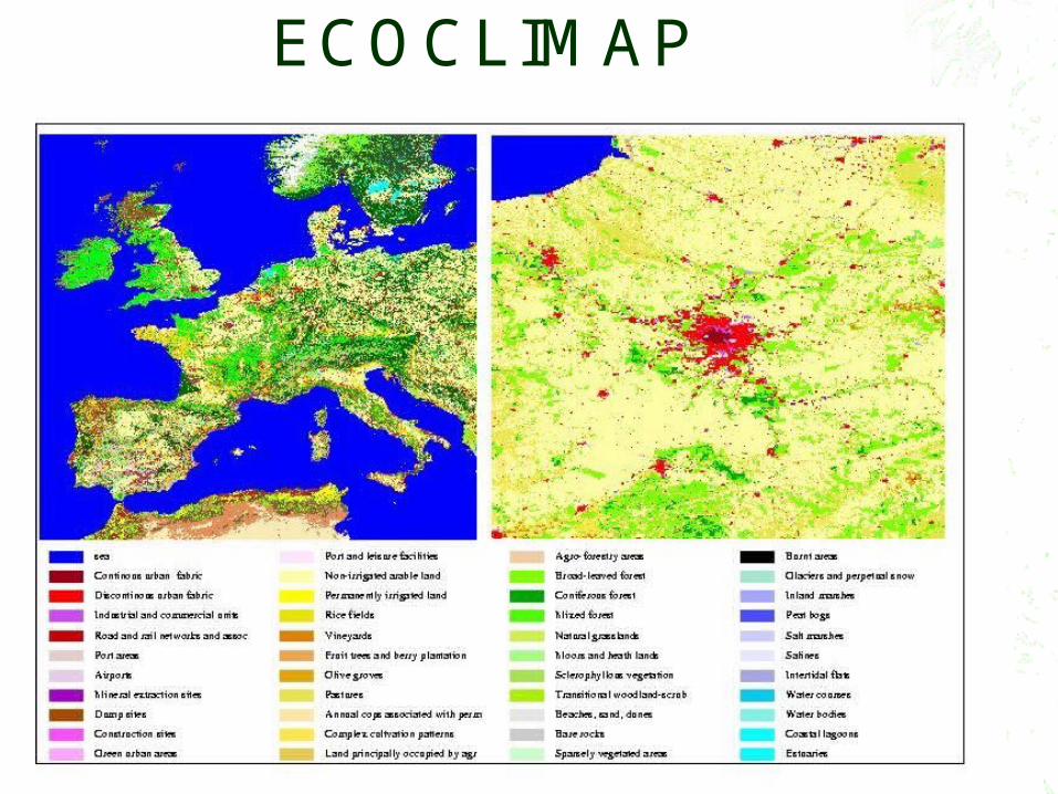
ECOCLIMAP

October 2005 27th EWGLAM & 12th SRNWP Meetings
2317
ECOCLIMAP database(Masson et al., 2003)
Global and high resolution dataset (1-km). Detailed information over Europe coming from CORINE and
PELCOM projects. Use of full resolution maps of the vegetation index NDVI to
provide the appropiate temporal and spatial scales. 215 ecosystems allowing a better assignement of vegetation
parameter sets. (90 over Europe) Use of aggregation rules to derive surface parameters at the
desired model resolution and for mixed ecosystem pixels. Vegetation parameters (veg, lai, Zoh, Zom, alb, Rsmin, frac,
emis, ...) with monthly or decennial (10 days) frequency. It allows the tiling approach, as used by the HIRLAM surface
scheme.

October 2005 27th EWGLAM & 12th SRNWP Meetings
24


![Magyar Társasjátékdíjjatekdij.hu/tartalom/tarsasjatek/Sarkany-palota.pdf · palota felsó smnt]éról kell elvennie. Ez után a másik ugyanolyan elérhetó sárkánylapkát választja](https://img.pdfslide.net/doc/110x75/61225268a91e1a79674191b9/magyar-trsasjtkd-palota-fels-smntrl-kell-elvennie-ez-utn-a-msik.jpg)