Embed Size (px)
Citation preview

2012
Muravha Sedzani Elia
University of Pretoria
6/2/2012
Report on Engineering Geological Investigation:
Test pit logs in KwaMhlanga for RDP houses development.
Department of Geology
GTX 713
Date Excavated: 18 April 2012
Machine: Bell 315SG
Operator: Lesley
Date Excavated: 19 April 2012
Machine: Bell 315SG
Operator: Lianas
Location: Mpumalanga (KwaMhlanga)

University of Pretoria
June 2, 2012
KwaMhlanga Test Pits: 18 April 2012 Page 1
Table of Contents
Pages
1. Introduction ………………………………………………….. 3
1.1 Aim and scope………………………………………………………………. 3
1.2 Available Information……………………………………………………….. 3
1.3 Methodology………………………………………………………………… 3
2. Site Description…………………………………………………. 3
2.1 Occurrence…………………………………………………………………… 3
2.3 Description of Geology………………………………………………………. 4
3. Methodology……………………………………………………. 4
4. Results and Engineering geological constraints………………... 6
4.1 Site Stratigraphy…………………………………………………………….. 6
4.2 Material Properties…………………………………………………………… 7
4.4 Hydrogeology………………………………………………………………… 7
5. Conclusion………………………………………………………. 9
6. References………………………………………………………. 9
Appendixes
Pages
Appendix A. Photographic exposure of the area and soil features……………………. 10
Appendix B. Photographic soil profiles of all test pits ……………………………….. 12
Appendix C. Stratigraphic soil profile description of all test pits…………………….. 20
List of figures
Figure 1: Locality of the study area……………………………………………………… 4
Figure 2: Location of all test pits, hydrological and geological conditions with development
illustration………………………………………………………………………………… 6

University of Pretoria
June 2, 2012
KwaMhlanga Test Pits: 18 April 2012 Page 2
Figure 3: Hydrogeological conditions illustration on a third test pit profile……………… 8
List of tables
Table 1: Typical guidelines for various stages of site investigation……………………… 5
Table 2: Stratigraphic soil profile description of first test pit…………………………….. 7
Table 3: Engineering geological classification for urban development ………………….. 8
List of acronyms
AEGSA Association of Engineering Geologists-South Africa
Ei Photographic exposure
MCCSSO Moisture, Colour, Consistency, Structure, Soil texture and Origin
RDP Reconstruction and Development Programme
SAICE South African Institution of Civil Engineering
SAIEG South African Institute for Engineering and Environmental Geologists
SANS South African National Standards
TP Test pit

University of Pretoria
June 2, 2012
KwaMhlanga Test Pits: 18 April 2012 Page 3
1. Introduction
Geotechnical investigations of this report were carried out by an Environmental and
Engineering Geology masters student and Hydrogeology honours student from the
University of Pretoria as a part of educational project under supervision of Matthys A.
Dippenaar. A site is located in KwaMhlanga, Mpumalanga near the R573 road well-known
as Moloto road and neighbouring villages are Kameelpoort, Tweefontein, Phola pan, etc.
Test pits were excavated in the field and results were recorded from all test pits. Test pit is a
hole excavated by hand or mechanical excavator for the purpose of direct and visual
inspection of the vertical section of soil and rocks in a profile as a part of site investigation
in geotechnical survey (SAICE 2010).
1.1 Aim and scope
The aim of this report is to provide detailed information and visual field inspection of
geotechnical conditions from test pit logs on site for the purpose of Reconstruction and
Development Programme (RDP) houses in KwaMhlanga village.
Objectives of the geotechnical investigation of the site include:
Planning of the investigation
Collection of available data from published documents.
Excavation of test pits in the site
Soil profiling and collecting samples from other test pits
The data gathered will address the excavatability, material properties and other
geotechnical features.
1.2 Available Information
Available information used to support the investigation was:
Google Earth Imagery (©2012 AfriGIS & Cnes/Spot Image)
Available published articles, SANS, Geotechnical code of practice and books
2. Site Description
2.1 Occurrence
A Google Map imagery of a site is provided below and it provides information about the
vegetation and few terrain features. The image depicts the whole area of KwaMhlanga village,
indicated as a red bordered area. An investigation site is situated in KwaMhlanga (area inside
red border in the image below) area at an approximate coordinates of 25022’41”S
028042’19.14”E near R568 and R573 roads.

University of Pretoria
June 2, 2012
KwaMhlanga Test Pits: 18 April 2012 Page 4
Figure 1: Locality of the study area (© 2012 Google Map)
KwaMhlanga is a village situated at Mpumalanga, South Africa in Thembisile Hani
Municipality located in the western region of the Nkangala District municipality.
KwaMhlanga is a rural area characterised by high unemployment, low economic base and is
isolated, with Ndebele as a common South African language (Nkangala district municipality
2010).
2.2 Description of Geology
An investigation site is situated in Mpumalanga and the insitu soil in all test pits at deeper
depth is residual granite. Quartz was a predominant grain in the soils from all test pits and the
insitu bedrock in all test pits was Lebowa granite. The bedrock was not weathered and in
some test pits it was discoloured.
3. Methodology
The fieldwork was carried out on the 18 April 2012 by Muravha Elia and Brendon Jones, and
completed on the 19th of April 2012 by Brendon Jones. The fieldwork comprises of test
pitting, soil profiling and description of engineering geological, geological and
hydrogeological conditions. The investigation was carried out based on a site investigation
code of practice (SAICE 2010), SANS (2009) Geotechnical Investigations for Township
Development and guidelines for soil and rock logging in South Africa (Brink and Bruin
1990). A Bell 315SG excavating machine was used to dig all test pits. Immediately after
N

University of Pretoria
June 2, 2012
KwaMhlanga Test Pits: 18 April 2012 Page 5
excavation of a test pit, soil profiling was conducted and all the geotechnical, geological and
hydrogeological conditions were recorded. All the vertical sections of soil in the profile were
described in terms of their moisture condition, colour, consistency, structure, soil texture and
origin (MCCSSO). MCCSSO provides basic information about the soil profile and make it
easier to recognise geotechnical conditions of the area and also gives quantitative assessment
of material properties (Brink and Bruin 1990). Guidelines of a site investigation were
introduced and followed during the investigation.
Table 1: Typical guidelines for various stages of site investigation (SAICE 2010)

University of Pretoria
June 2, 2012
KwaMhlanga Test Pits: 18 April 2012 Page 6
These guidelines for stages of a site investigation suggest the level at which the various types
of investigation should be carried out and also provide scope, methodology and application
ranges to be used during investigation (Van Rooy and Stiff 2001). RDP houses construction
falls into large area development class according to the guidelines of site investigation as
shown in Table 1. Housing complex requires one data point per hectare or one per structure
according to the guidelines (Brink and Bruin 1990).
4. Results and Engineering geological constraints
In the investigation, twenty-six test pits were dug and their soil profiles were analysed and
samples from some test pits were taken.
Figure 2: Location of all test pits, hydrological and geological conditions with development
illustration (© 2012 Google Earth).
Figure two depicts the location of all test pits and other environmental features around the
area. The photographic exposures of the area, all test pits and soil features are given in the
APPENDIX A. and B. Recent development around the area of investigation and other
engineering geological and hydrogeological features such as borrow pits and wetland
delineations are provided in Fig. 2. Some other test pits were characterised by collapsible wall
due to perched waters and type of soils present.
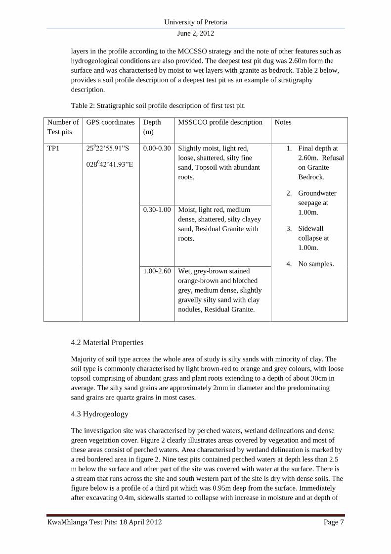
4.1 Site Stratigraphy
The soil profiles of all test pits are provided in the APPENDIX C. with the coordinates, depth
(m) of soil layers in the profile from surface to a non-excavatable depth, description of all
University of Pretoria
June 2, 2012
KwaMhlanga Test Pits: 18 April 2012 Page 7
layers in the profile according to the MCCSSO strategy and the note of other features such as
hydrogeological conditions are also provided. The deepest test pit dug was 2.60m form the
surface and was characterised by moist to wet layers with granite as bedrock. Table 2 below,
provides a soil profile description of a deepest test pit as an example of stratigraphy
description.
Table 2: Stratigraphic soil profile description of first test pit.
Number of
Test pits
GPS coordinates Depth
(m)
MSSCCO profile description Notes
TP1 25022’55.91”S
028042’41.93”E
0.00-0.30
Slightly moist, light red,
loose, shattered, silty fine
sand, Topsoil with abundant
roots.
1. Final depth at
2.60m. Refusal
on Granite
Bedrock.
2. Groundwater
seepage at
1.00m.
3. Sidewall
collapse at
1.00m.
4. No samples.
0.30-1.00
Moist, light red, medium
dense, shattered, silty clayey
sand, Residual Granite with
roots.
1.00-2.60
Wet, grey-brown stained
orange-brown and blotched
grey, medium dense, slightly
gravelly silty sand with clay
nodules, Residual Granite.
4.2 Material Properties
Majority of soil type across the whole area of study is silty sands with minority of clay. The
soil type is commonly characterised by light brown-red to orange and grey colours, with loose
topsoil comprising of abundant grass and plant roots extending to a depth of about 30cm in
average. The silty sand grains are approximately 2mm in diameter and the predominating
sand grains are quartz grains in most cases.
4.3 Hydrogeology
The investigation site was characterised by perched waters, wetland delineations and dense
green vegetation cover. Figure 2 clearly illustrates areas covered by vegetation and most of
these areas consist of perched waters. Area characterised by wetland delineation is marked by
a red bordered area in figure 2. Nine test pits contained perched waters at depth less than 2.5
m below the surface and other part of the site was covered with water at the surface. There is
a stream that runs across the site and south western part of the site is dry with dense soils. The
figure below is a profile of a third pit which was 0.95m deep from the surface. Immediately
after excavating 0.4m, sidewalls started to collapse with increase in moisture and at depth of

University of Pretoria
June 2, 2012
KwaMhlanga Test Pits: 18 April 2012 Page 8
0.5m we intersected groundwater seepage. At depth between 0.5-0.95m, there was abundance
of pebbles and cobbles with very wet soils and increased seepage. Description of
hydrogeological conditions of all test pits is given in the APPENDIX C.
Figure 3: Hydrogeological conditions illustration on a third test pit profile.
The engineering geological constrains from all the test pits were analysed and the results are
given in the table below. Most test pits were characterised by different constraints such as
collapsible soil, seepage, active soil, area of unstable natural slopes, excavatability and
erodability of soil. More than five test pits had seepage waters which facilitated sidewall
collapse. The area was covered with vegetation and traces of active soils were encountered in
other test pits. Vegetation across the area reduced soil erodability and the area was
characterised by uniform slopes.
Table 3: Engineering geological classification for urban development after Partridge, Wood
and Brink (National department of housing 2002).
Constraint Site Condition Class
A Collapsible soil Any collapsible horizon or consecutive
horizons totalling a depth of less than 750
mm in thickness
1
TP3

University of Pretoria
June 2, 2012
KwaMhlanga Test Pits: 18 April 2012 Page 9
B Seepage Permanent or perched water table less than
1.5 m below
ground surface
2
C Active Soil Moderate soil heave potential predicted 2
D Area of unstable natural
slopes
Intermediate risk 2
E Difficulty of excavation to
1.5m depth
Rock or hardpan pedocretes between 10 %
and 40 % of the total volume (shallower than
1.50 m)
2
F Erodability of soil Low 1
Class: 1-Most favourable, 2-Intermediate, 3-Least favourable
5. Conclusion
The investigation site is situated in KwaMhlanga and underlain by Lebowa granite. A Bell
315SG excavating machine was used to dig all test pits and soil profiling was conducted
after excavation and all the geotechnical, geological and hydrogeological conditions were
recorded for each test pit. The visual inspection of vertical section of each soil profile was
described in terms of its MCCSSO. Guidelines for site investigation were used and twenty-
six test pits were dug. The investigation area was characterised by wetland delineation,
borrow pits, recent development, vegetation cover, surface and subsurface water bodies.
Nine test pits had water seepage and most of these pits experienced sidewall collapse.
Engineering geological constraints recorded in a site include collapsible soil, seepage, active
soil, area of unstable natural slopes, excavatability and erodability of soil.
6. References
1. Brink, A.B.A and Bruin R.M.H. (1990). Guidelines for soil and rock logging in South
Africa. 2nd Impression 2002. SAICE, SAIEG and AEGSA: South Africa.
2. National department of housing. (2002).Geotechnical Site Investigations for Housing
Development: Project linked Greenfield subsidy project development. Generic
specification GFSH-2: Republic of South Africa
3. Nkangala district municipality (2010). Final Integrated Development Plan. Unknown
publisher: South Africa. Pp 1-315
4. SANS [South African National Standards]. 2009. Geotechnical Investigations for
Township Development. South African Bureau of Standards. Draft SANS 634:2009.
Pretoria.
5. The South African Institution of Civil Engineering (2010). Site Investigation Code of
Practice. 1st Edition. South African Institution of Civil Engineering - Geotechnical
Division
6. Van Rooy, J.L and Stiff, J.S. (2001). Guidelines for urban engineering geological
investigations in South Africa. Springer-Verlag: 59:285 –295

University of Pretoria
June 2, 2012
KwaMhlanga Test Pits: 18 April 2012 Page 10
Appendix A. Photographic exposure of the area and soil features

University of Pretoria
June 2, 2012
KwaMhlanga Test Pits: 18 April 2012 Page 11
E1 E2
E4 E3

University of Pretoria
June 2, 2012
KwaMhlanga Test Pits: 18 April 2012 Page 12
Appendix B. Photographic soil profiles of all test pits

University of Pretoria
June 2, 2012
KwaMhlanga Test Pits: 18 April 2012 Page 13
TP1
TP3
TP2
TP4

University of Pretoria
June 2, 2012
KwaMhlanga Test Pits: 18 April 2012 Page 14
TP5
TP7
TP6
TP8

University of Pretoria
June 2, 2012
KwaMhlanga Test Pits: 18 April 2012 Page 15
TP10 TP9
TP12 TP11

University of Pretoria
June 2, 2012
KwaMhlanga Test Pits: 18 April 2012 Page 16
TP16
TP15
TP13 TP14

University of Pretoria
June 2, 2012
KwaMhlanga Test Pits: 18 April 2012 Page 17
TP17
TP19 TP20
TP18

University of Pretoria
June 2, 2012
KwaMhlanga Test Pits: 18 April 2012 Page 18
TP21 TP22
TP24 TP23
University of Pretoria
June 2, 2012
KwaMhlanga Test Pits: 18 April 2012 Page 19
TP25 TP26

University of Pretoria
June 2, 2012
KwaMhlanga Test Pits: 18 April 2012 Page 20
Appendix C. Stratigraphic soil profile description of all test pits

University of Pretoria
June 2, 2012
KwaMhlanga Test Pits: 18 April 2012 Page 21
Number of
Test pits
GPS coordinates Depth
(m)
MSSCCO profile description Notes
TP1 25022’55.91”S
028042’41.93”E
0.00-0.30
Slightly moist, light red,
loose, shattered, silty fine
sand, Topsoil with abundant
roots.
5 Final depth at
2.60m. Refusal on
Granite Bedrock.
6 Groundwater
seepage at 1.00m.
7 Sidewall collapse
at 1.00m.
8 No samples.
0.30-1.00
Moist, light red, medium
dense, shattered, silty clayey
sand, Residual Granite with
roots.
1.00-2.60
Wet, grey-brown stained
orange-brown and blotched
grey, medium dense, slightly
gravelly silty sand with clay
nodules, Residual Granite.
TP2 25022’51.94”S
028042’40.48”E
0.00-0.10
Moist, light red, loose,
shattered, slightly clayey silty
fine sand, Topsoil with
abundant roots.
1. Final depth at
0.90m.
Groundwater
table
intersected.
2. Groundwater
seepage at
0.20m.
3. Sidewall
collapse at
0.20m.
4. No samples.
5. Water ponding
visible within
adjacent to test
pit.
0.10-0.50
Wet, light red blotched brown
and grey, loose, shattered,
clayey sand with fine gravel,
Residual Granite
0.50-0.90
Very wet, grey blotched dark
brown, loose, shattered,
clayey sand, Residual Granite.
TP3 25022’49.82”S
028042’37.95”E
0.00-0.20
Moist, dark brown, loose to
medium dense, shattered, silty
sand, Topsoil with abundant
roots.
1. Final depth at
0.95m.
Groundwater
table

University of Pretoria
June 2, 2012
KwaMhlanga Test Pits: 18 April 2012 Page 22
0.20-0.50
Wet, grey brown streaked
orange-brown, loose,
shattered, silty fine to medium
sand, Residual Granite
intersected.
2. Groundwater
seepage at
0.50m.
3. Sidewall
collapse at
0.40m.
4. No samples.
0.50-0.95
Very wet, light brown grey
stained orange-brown at
depth, loose, shattered to
intact, sandy gravel with
abundant pebbles and cobbles,
Residual Granite.
TP4 25022’46.90”S
028042’34.40”E
0.00-0.10
Moist, dark brown, speckled
orange-brown, loose to
medium dense, micro-
shattered, silty sand, Topsoil
with abundant roots.
1. Final depth at
1.25m.
Groundwater
table
intersected.
2. Groundwater
seepage at
1.10m.
3. Sidewall
collapse at
0.60m.
4. Foundation
indicator
sample: 0.65-
1.25m.
0.10-0.65
Wet, light grey-brown stained
orange-brown with depth,
loose, shattered, silty sand
with abundant gravel with
depth, Residual Granite.
0.65-1.25
Moist to wet with depth, pale
pink-brown stained dark
orange-brown, loose,
shattered, silty gravelly sand
with clay nodules, Residual
Granite.
TP5 25022’45.91”S
028042’29.65”E
0.00-0.10
Moist, dark brown speckled
orange-brown, medium dense,
micro-shattered, slightly
clayey silty fine sand, Topsoil
with roots.
1. Final depth at
1.75m. Refusal
on granite
bedrock.
2. Groundwater
seepage at
1.00m.
3. Sidewall
collapse at
0.40m.
4. No sample.
0.10-0.75
Wet, light grey-brown stained
orange-brown with depth,
loose, shattered, silty sand
with abundant gravel with
depth and occasional boulders,
Residual Granite.

University of Pretoria
June 2, 2012
KwaMhlanga Test Pits: 18 April 2012 Page 23
TP6 25022’49.41”S
028042’29.26”E
0.00-0.20
Slightly moist, light brown,
loose to medium dense,
micro-shattered, silty fine
sand, Topsoil with few roots.
1. Final depth at
0.95m. Refusal
on very dense
residual
granite.
2. No
groundwater
seepage.
3. No sidewall
collapse.
4. No sample.
0.20-0.65
Dry, dark grey-brown, dense,
intact, fine gravelly silty sand,
Residual Granite.
TP7 25022’44.30”S
028042’25.14”E
0.00-0.15
Moist, dark brown, loose,
micro-shattered, silty sand,
Topsoil with abundant roots.
1. Final depth at
0.80m.
Groundwater
table
intersected.
2. Groundwater
seepage at
0.80m.
3. Sidewall
collapse at
0.80m.
4. No sample.
0.15-0.80
Wet, dark brown speckled
orange-brown and blotched
pale grey-brown, very loose to
loose, shattered, silty sand,
Residual Granite.
0.40-0.70
Dry, light brown stained
orange-brown with depth,
loose to medium dense,
shattered, silty sandy gravel,
Colluvium. Gravel fragments
are sub-rounded and increase
in size with depth.
0.70-1.05
Dry, dark reddish orange-
brown, medium dense to
dense with depth, shattered,
silty sandy gravel with
cobbles and pebbles,
Ferruginised Residual Granite.

University of Pretoria
June 2, 2012
KwaMhlanga Test Pits: 18 April 2012 Page 24
TP9 25022’48.26”S
028042’22.75”E
0.00-0.20
Dry, light brown, medium
dense, intact, silty sand,
Topsoil with few roots.
1. Final depth at
0.65m. Refusal
on very dense
residual
granite.
2. No
groundwater
seepage.
3. No sidewall
collapse.
4. Foundation
indicator
sample at 0.20-
0.45m.
0.20-0.45 Dry, dark brown blotched
dark purple-brown, firm,
shattered and slickensides,
silty fine sandy clay, Residual
Granite.
0.45-0.65
Dry, pale pink-brown
speckled orange-brown,
dense, shattered, silty sand,
Residual Granite.
TP10 25022’51.92”S
028042’27.53”E
0.00-0.30
Slightly moist, dark brown
speckled pink-brown, loose,
shattered, silty fine-sand,
Colluvium.
1. Final depth at
0.65m. Refusal
on very dense
residual
granite.
2. No
groundwater
seepage.
3. No sidewall
collapse.
4. Foundation
indicator
sample at 0.30-
0.60m.
0.30-0.60
Moist, dark brown speckled
orange-brown, soft to firm,
intact, fine sandy clay,
Residual Granite.
0.60-1.55
Moist, pale pink-brown,
stained orange-brown,
medium dense to dense,
shattered, slightly silty sand,
Residual Granite.
TP11 25022’55.31”S
028042’33.14”E
0.00-0.10
Slightly moist, dark brown
speckled pink-brown, loose,
shattered, silty fine-sand,
Colluvium.
1. Final depth at
0.80m.
Groundwater
table
intersected.
2. Groundwater
seepage at
1.40m.
0.10-0.70
Moist, light brown speckled
dark brown, loose, shattered,
slightly clayey silty fine sand,
Residual Granite.

University of Pretoria
June 2, 2012
KwaMhlanga Test Pits: 18 April 2012 Page 25
0.70-1.70
Wet, pale brown stained
orange-brown, medium dense
becoming dense with depth,
shattered, silty gravelly sand
with clay nodules.
3. No sidewall
collapse.
4. No sample.
TP12 25022’48.23”S
028042’14.90”E
0.00-0.10
Slightly moist, dark brown
speckled pink-brown, loose,
shattered, silty fine-sand,
Topsoil.
1. Final depth at
0.75m. Refusal
on very dense
residual
granite.
2. No
groundwater
seepage.
3. No sidewall
collapse.
4. No sample.
0.10-0.75
Dry, light brown stained
orange-brown with depth,
loose to medium dense, intact
to shatter with depth, clayey
silty fine sand with fine gravel
at depth, Residual Granite.
TP13 25022’51.87”S
028042’18.50”E
0.00-0.20
Slightly moist, dark brown
speckled pink-brown, loose,
shattered, silty fine-sand,
Topsoil with abundant roots.
1. Final depth at
1.30m. Refusal
on granite
bedrock.
2. Slight
groundwater
seepage at
1.10m.
3. Sidewall
collapse at
1.10m.
4. No sample.
0.20-0.80
Slightly moist, light brown
stained orange-brown, loose,
shattered, silty sand, Residual
Granite.
0.80-1.10
Wet, grey stained orange-
brown, loose, shattered, sandy
clayey gravel, Residual
Granite
1.10-1.30
Orange-brown speckled and
blotched light brown and
yellow-brown, highly
weathered, medium to very
coarse grained, very soft to
soft rock, Granite, Lebowa
Granite Suite.
TP14 25022’51.72”S
028042’09.32”E
0.00-0.35
Dry, light brown, loose to
medium dense, shattered, silty
fine-sand, Topsoil with
abundant roots.
1. Final depth at
0.65m. Refusal
on granite
bedrock.

University of Pretoria
June 2, 2012
KwaMhlanga Test Pits: 18 April 2012 Page 26
0.35-0.65
Dry, light brown stained
orange-brown, medium dense
to dense, shattered, silty
gravelly sand becoming
gravelly approaching bedrock,
Ferruginised Residual Granite.
2. No
groundwater
seepage.
3. No sidewall
collapse.
4. No sample.
TP15 25022’54.38”S
028042’00.47”E
0.00-0.20
Dry, light brown, medium
dense becoming loose,
shattered, silty fine-sand,
Topsoil with few roots.
1. Final depth at
0.65m. Refusal
on granite
bedrock.
2. No
groundwater
seepage.
3. No sidewall
collapse.
4. No sample.
0.20-0.65
Dry, light yellow-brown
stained dark purple orange-
brown and dark purple-
orange, loose, shattered, silty
gravelly sand with increasing
gravel cobbles and pebbles
with depth, Ferruginised
Residual Granite.
TP16 25022’57.64”S
028041’51.67”E
0.00-0.20 Dry, light brown, loose to
medium dense, shattered, silty
fine-sand, Topsoil with few
roots.
1. Final depth at
0.90m. Refusal
on ferruginised
granite
bedrock.
2. No
groundwater
seepage.
3. No sidewall
collapse.
4. Foundation
indicator
sample at 0.20-
0.50m.
0.20-0.50
Moist, light brown speckled
orange-brown, loose,
shattered, silty fine sand with
gravel at depth, Residual
Granite.
0.50-0.90
Dry, light yellow-brown
stained dark purple orange-
brown and dark purple-
orange, loose to medium
dense, shattered, silty gravelly
sand with increasing gravel
cobbles and pebbles with
depth, Ferruginised Residual
Granite.
TP17 25023’00.51”S
028041’34.19”E
0.00-0.25
Dry, light brown, loose,
shattered, silty fine-sand,
Topsoil with few roots.
1. Final depth at
2.10m. Refusal
on granite

University of Pretoria
June 2, 2012
KwaMhlanga Test Pits: 18 April 2012 Page 27
0.25-2.10
Moist becoming wet, orange-
brown streaked and blotched
grey, soft to firm with depth,
shattered, silty sandy clay
with gravel pebbles cobbles
and boulders with depth,
Residual Granite.
bedrock.
2. Groundwater
seepage at
1.10m.
3. No sidewall
collapse.
4. Foundation
indicator
sample at 0.25-
2.10m.
TP18 25022’47.73”S
028042’02.08”E
0.00-0.10
Slightly moist, light brown
speckled and stained orange-
brown, loose, shattered, silty
sand with increasing gravel,
Residual Granite.
1. Final depth at
1.25m. Refusal
on granite
bedrock.
2. No
groundwater
seepage.
3. No sidewall
collapse.
4. No sample.
0.75-1.25
Dry, light yellow-brown
stained dark purple orange-
brown and dark purple-
orange, loose, shattered, silty
gravelly sand with increasing
gravel cobbles and pebbles
with depth, Ferruginised
Residual Granite.
TP19 25022’44.18”S
028042’00.40”E
0.00-0.15
Moist, dark brown, loose,
shattered, silty sand, Topsoil
with abundant roots.
1. Final depth at
1.10m. Refusal
on granite
bedrock.
2. Groundwater
table
intersected at
1.00m.
3. No sidewall
collapse.
4. No sample.
0.15-1.10
Moist becoming very wet,
pale pink-brown stained
orange-brown, loose,
shattered, silty clayey sand
with gravel, Residual Granite.
TP20 25022’46.76”S
028041’53.75”E
0.00-0.10
Dry, light brown, loose,
shattered, silty fine-sand,
Topsoil with few roots.
1. Final depth at
1.10m. Refusal
on granite

University of Pretoria
June 2, 2012
KwaMhlanga Test Pits: 18 April 2012 Page 28
0.10-0.80
Slightly moist, light brown
speckled and stained orange-
brown, loose, shattered, silty
sand with increasing gravel,
Residual Granite.
bedrock.
2. Groundwater
seepage at
1.50m.
3. Sidewall
collapse at
2.10m.
4. Foundation
indicator
sample at 0.80-
2.20m.
0.80-2.20
Moist becoming very wet,
orange-brown streaked and
blotched grey, soft, shattered,
silty sandy clay with gravel
pebbles cobbles and boulders
with depth, Residual Granite.
TP21 25022’46.67”S
028041’49.06”E
0.00-0.40
Dry, light brown streaked and
mottles light grey and yellow-
brown and stained orange-
brown, loose to medium dense
with depth, shattered, silty
gravelly sand with cobbles
and pebbles, Residual Granite.
1. Final depth at
0.65m. Refusal
on granite
bedrock.
2. No
groundwater
seepage.
3. No sidewall
collapse.
4. Foundation
indicator
sample at 0.00-
0.40m.
5. Test pit located
within an
exploited
borrow pit.
TP22 25022’41.03”S
028041’50.82”E
0.00-0.15
Dry, light brown, loose,
shattered, silty fine-sand,
Topsoil with few roots.
1. Final depth at
2.00m. Refusal
on very dense
residual
granite.
2. No
groundwater
seepage.
3. No sidewall
collapse.
4. Foundation
0.15-2.00
Moist, orange-brown, loose
becoming medium dense with
depth, shattered, silty fine
gravelly sand, Residual
Granite.

University of Pretoria
June 2, 2012
KwaMhlanga Test Pits: 18 April 2012 Page 29
indicator
sample at 0.15-
2.00m.
TP23 25022’34.24”S
028041’44.59”E
0.00-0.20
Dry, light brown, loose,
micro-shattered, silty fine
sand, Topsoil with abundant
roots.
1. Final depth at
1.70m. Refusal
on dense
residual
granite.
2. No
groundwater
seepage.
3. No sidewall
collapse.
4. No samples.
5. Test pit located
approximately
50m north-east
of an existing
borrow pit.
0.20-1.70
Slightly moist, reddish brown
speckled dark grey and light
brown, loose becoming
medium dense at depth,
shattered, to intact, silty sand
with abundant gravel and
occasional cobbles and
pebbles with depth, Residual
Granite.
TP24 25022’25.01”S
028042’03.45”E
0.00-0.25
Dry, light brown, loose,
shattered, silty fine sand,
Topsoil with abundant roots.
1. Final depth at
1.10m. Refusal
on granite
bedrock.
2. No
groundwater
seepage.
3. No sidewall
collapse.
4. No samples.
0.25-1.10
Slightly moist, reddish-brown
stained orange-brown, loose to
medium dense, shattered to
intact, silty gravelly sand with
granite boulders at depth,
Residual Granite.
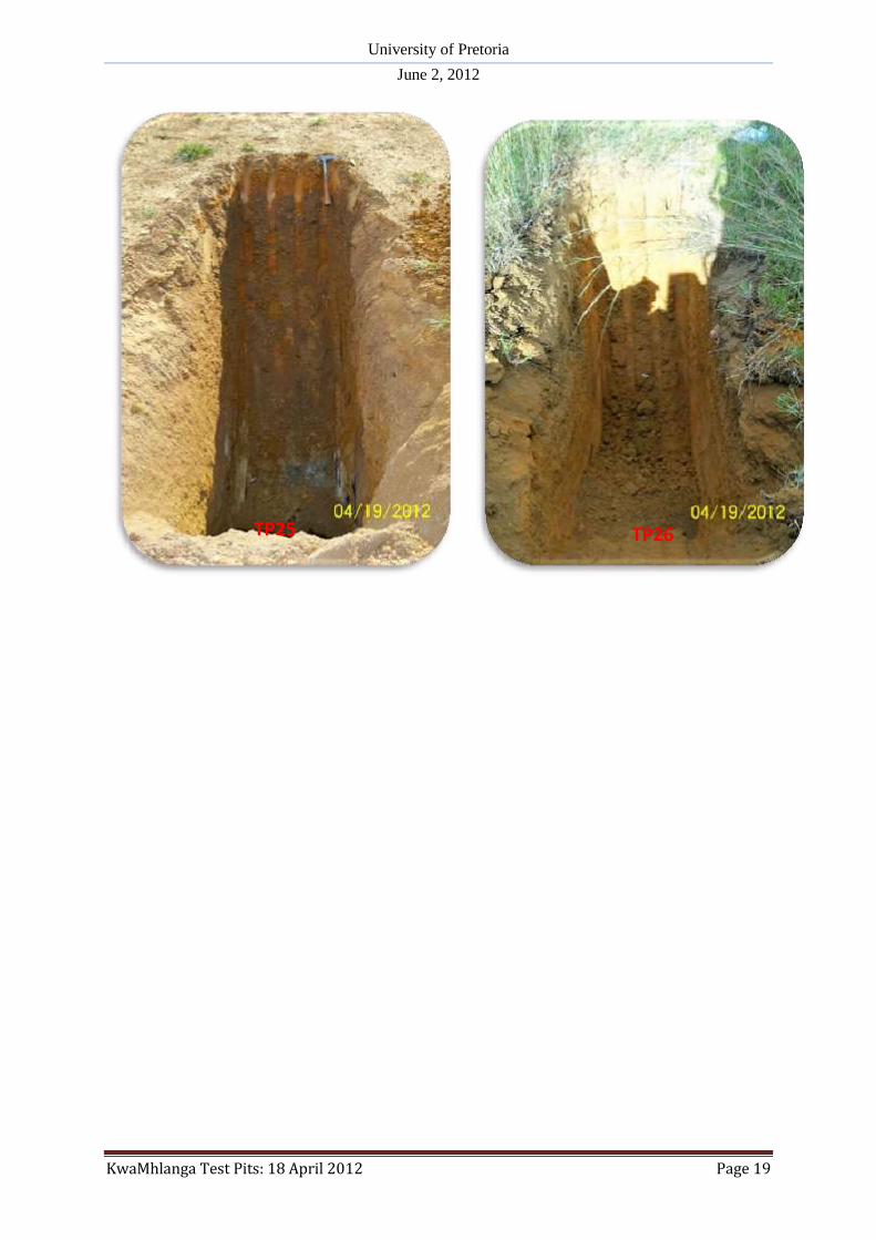
TP25 25022’29.95”S
028042’30.10”E
0.00-0.15
Dry, light brown, medium
dense, shattered fine gravelly
silty sand, Reworked Residual
Granite (Roadworks)
1. Final depth at
1.65m. Refusal
on very dense
residual
granite.
2. No
groundwater
seepage.
0.15-0.65
Slightly moist, light reddish
brown stained orange-brown,
loose, shattered, gravelly silty
sand, Residual Granite.

University of Pretoria
June 2, 2012
KwaMhlanga Test Pits: 18 April 2012 Page 30
0.65-1.65
Moist, reddish brown stained
orange-brown streaked light
grey, medium dense to dense,
shattered, silty gravelly sand
with clay nodules cobbles and
pebbles, Residual Granite.
3. No sidewall
collapse.
4. No samples.
TP26 25022’23.55”S
028042’19.03”E
0.00-0.25
Dry, light brown, loose,
shattered, silty fine sand,
Topsoil with abundant roots.
1. Final depth at
1.65m. Refusal
on very dense
residual
granite.
2. No
groundwater
seepage.
3. No sidewall
collapse.
4. No samples.
0.25-0.50
Slightly moist, light brown
stained orange-brown
becoming orange-brown at
depth, loose, shattered,
gravelly silty sand, Residual
Granite.
0.50-1.25
Slightly moist, reddish brown
stained orange-brown streaked
light grey, medium dense to
dense, shattered, silty gravelly
sand with clay nodules
cobbles and pebbles, Residual
Granite.