Embed Size (px)
Citation preview
P-06-82
Oskarshamn site investigation
Comparative geological logging with the Boremap system: 9.6–132.2 m of borehole KLX07B
Jesper Petersson, Göran Skogsmo, Johan Berglund
SwedPower AB
Allan Stråhle, Geosigma AB
May 2006
Svensk Kärnbränslehantering ABSwedish Nuclear Fueland Waste Management CoBox 5864SE-102 40 Stockholm Sweden Tel 08-459 84 00 +46 8 459 84 00Fax 08-661 57 19 +46 8 661 57 19
ISSN 1651-4416
SKB P-06-82
Oskarshamn site investigation
Comparative geological logging with the Boremap system: 9.6–132.2 m of borehole KLX07B
Jesper Petersson, Göran Skogsmo, Johan Berglund
SwedPower AB
Allan Stråhle, Geosigma AB
May 2006
Keywords: KLX07B, Geology, Drill core, Comparative mapping, BIPS, Boremap, Fractures, Laxemar, AP PF 400-05-086.
This report concerns a study which was conducted for SKB. The conclusions and viewpoints presented in the report are those of the authors and do not necessarily coincide with those of the client.
A pdf version of this document can be downloaded from www.skb.se
�
Abstract
This report presents the results from four days of geological mapping of KLX07B, a 200 metres deep, cored borehole in the subarea Laxemar, by using the Boremap system. The mapping is part of a project initiated to evaluate possible differences in the geological judgement and the methodology used for the drill core logging at Forsmark and subarea Laxemar site investigation areas. During the four days period, an interval from 9.6 to 1�2.2 metres of KLX07B was mapped. All lithological features that occur within this interval have been registered and documented with the same criteria used by the SwedPower team during the regular geological logging of boreholes in the Forsmark area.
The 122.6 metres long interval of KLX07B is dominated by a slightly K-feldspar porphyritic granite to quartz monzodiorite. Other frequent rock units in the interval include fine-grained mafic rocks, granite of variable grain-size and pegmatite. The most conspicuous of these occurrences is a ca 1.5 metre long interval of fine-grained mafic rock. None of the other occurrences exceed one metre in length, and the majority is less than one decimetre. All rocks in the mapped interval are rather massive and obviously post-kinematic, though the slightly K-feldspar porphyritic granite to quartz monzodiorite exhibits generally a faint planar mineral fabric. Thirteen minor zones of more intense ductile and brittle-ductile deformation have been registered in the mapped interval of KLX07B. Except for a few minor zones in the interval 129.84–1�0.16 metres (adjusted length), all of them are limited to the upper 60 metres of the mapped part of the borehole. A weak to medium oxidation of feldspars is generally associated with more intensely fractured intervals. A more or less continuous interval of oxidation, locally combined with chloritization and argillization occurs in the 16 lowermost metres of the mapped interval.
The total number of fractures registered in the 122.6 metres long interval of KLX07B amounts to 702. Of these are 276 open, 18 partly open and 408 sealed. Thirteen narrow crush zones occur in the interval. There is three sections with somewhat increased fracture frequency: 9.6–4�, 86–9� and 116–1�2.2 metres adjusted length. One distinct fracture set, which includes both sealed and open fractures, can be distinguished in the interval. Fractures of this set are generally striking NW-SE and dip gently towards northeast. In addition, there are a number of moderately dipping fractures with highly variable strikes. Interestingly, there are few vertical to sub-vertical fractures. Possibly, this might reflect a bias in data due to the fact that the borehole is drilled near-vertical. The maximum aperture of the fractures registered in the mapped interval of KLX07B is 4 millimetres.

4
Sammanfattning
Föreliggande rapport redovisar resultaten från fyra dagars Boremapkartering av KLX07B, ett 200 meter djupt kärnborrhål i delområde Laxemar. Karteringen ingår i ett projekt för att utvärdera eventuella skillnader i geologiska bedömningar och metodiken som används vid borrkärnekartering i undersökningsområde Forsmark respektive delområde Laxemar. Under fyradagarsperioden karterades ett längd intervall från 9,6 till 1�2,2 meter av KLX07B. Alla strukturer och litologiska enheter som förekommer i intervallet registrerades och dokumenterades med samma kriterier som används av SwedPowers geologer vid den reguljära borrhålskarteringen i Forsmark.
Det 122,6 meter långa intervallet i KLX07B domineras av en svagt K-fältspatporfyrisk granit till kvartsmonzodiorit. Andra vanligt förekommande bergarter i intervallet är finkorniga mafiska bergarter, granit av varierande kornstorlek och pegmatit. Den mest påtagliga av dessa förekomster är ett ca 1,5 meter långt intervall av en finkornig mafisk bergart. Inga övriga enskilda förekomster överskrider en meter i borrhålslängd, och de flesta är mindre än en decimeter. Alla bergarter i det karterade intervallet är relativt massformiga och uppenbarligen post-kinematiska. Den svagt svagt K-fältspatporfyriska graniten till kvartsmonzodioriten uppvisar dock en mycket svag planstruktur. Tretton mindre zoner med mer kraftig duktil till spröd-duktil deformation har registrerats i det karterade intervallet av KLX07B. Frånsett ett fåtal mindre zoner i intervallet 129,84–1�0,16 meter (justerad längd), är alla begränsade till de övre 60 metrarna av den karterade delen. En svag till mycket svag oxidation av fältspater uppträder normalt i längdintervall som är mer kraftigt upp-spruckna. Ett mer eller mindre kontinuerligt intervall av oxidation, lokalt i kombination med kloritisering och leromvandling förekommer i de 16 understa metrarna av det karterade intervallet.
Det totala antalet sprickor som registrerats i det 122,6 meter långa intervallet av KLX07B uppgår till 702. Av dessa är 276 öppna, 18 partiellt öppna och 408 läkta. Tretton mindre krosszoner förekommer i intervallet. Tre sektioner med något förhöjd sprickfrekvens förekommer på följande nivåer: 9,6–4�, 86–9� och 116–1�2,2 meter justerad längd. Ett distinkt sprickset, som både inkluderar läkta och öppna sprickor, kan urskiljas i intervallet. Sprickor i detta set stryker generellt NV-SO och stupar flackt mot nordost. Dessutom finns ett antal något brantare sprickor med varierande strykning. Det bör noteras att det finns få vertikala till subvertikala sprickor. Möjligen beror detta på att vertikala sprickor är underrepresenterade i ett subvertikalt borrat hål. Den maximala aperturen som registrerats i den karterade delen av KLX07B är 4 millimeter.
5
Contents
1 Introduction 7
2 Objectiveandscope 9
3 Equipment 11�.1 Description of equipment/interpretation tools 11
4 Execution 1�4.1 General 1�4.2 Preparations 1�4.� Data handling 1�4.4 Analyses and interpretations 144.5 Nonconformities 15
5 Results 175.1 Core lithology 175.2 Ductile structures 175.� Alteration 185.4 Fractures 18
5.4.1 Fracture frequencies and orientations 185.4.2 Fracture mineralogy 19
Appendix1 WellCAD image 21Appendix2 Borehole diameters 2�Appendix3 Downhole deviation measurements 25

7
1 Introduction
Since 2002, SKB investigates two potential sites at Forsmark and Oskarshamn, for a deep repository in the Swedish Precambrian basement. In order to characterise the bedrock down to a depth of about 1 km at the two site investigation areas, SKB launched several extensive drilling programmes. A detailed geological logging of the drill cores obtained through the drilling programs is essential for subsequent sampling and borehole investigations, and consequently, for the three-dimensional modelling of the two sites. For this purpose, the so-called Boremap system has been developed. The system integrates results from geo-logical drill core logging, or alternatively, the drill cuttings when a core is not available, with information from BIPS-logging (Borehole Image Processing System) and calculates the absolute position and orientation of fractures and various planar lithological features (SKB MD 14�.006 and 146.005).
To assure the comparability between the two site investigation areas, it is essential that there is a general consensus in the geological judgements and the methodology used for the drill core logging. The subject has arisen as the geologists involved in the logging have been strictly tied to one of the site investigation areas, and the exchange of experiences is rather limited. In order to evaluate possible differences in the mapping, SKB initiated a project where the core logging teams at the two sites were switching locality to work with a drill core from the other site investigation area. The two boreholes chosen for the mapping were telescopic drilled borehole KFM06C from the Forsmark site investigation area and core drilled borehole KLX07B from the subarea Laxemar, which is part of the Simpevarp site investigation area at Oskarshamn.
This document reports the results from the comparative geological logging of borehole KFM07B performed by geologists from SwedPower AB. The activity is part of the site investigation at Oskarshamn. The work was carried out in accordance with activity plan AP PF 400-05-086. In Table 1-1 controlling documents for this activity are listed. Both activity plan and method descriptions are SKB’s internal controlling documents.
Table1‑1. Controllingdocumentsfortheperformanceoftheactivity.
Activityplan Number Version
Jämförande Boremapkartering på del av teleskopborrhål KFM06C och KLX07B
AP PF 400-05-086 1.0
Methoddocuments Number Version
Metodbeskrivning för Boremap-kartering Nomenklatur vid Boremap-kartering Mätsystembeskrivning för Boremapkartering, Boremap v. 3.0
SKB MD 143.006 SKB MD 143.008 SKB MD 146.005
2.0 1.0 1.0
9
2 Objectiveandscope
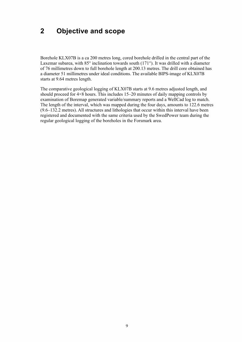
Borehole KLX07B is a ca 200 metres long, cored borehole drilled in the central part of the Laxemar subarea, with 85° inclination towards south (171°). It was drilled with a diameter of 76 millimetres down to full borehole length at 200.1� metres. The drill core obtained has a diameter 51 millimetres under ideal conditions. The available BIPS-image of KLX07B starts at 9.64 metres length.
The comparative geological logging of KLX07B starts at 9.6 metres adjusted length, and should proceed for 4×8 hours. This includes 15–20 minutes of daily mapping controls by examination of Boremap generated variable/summary reports and a WellCad log to match. The length of the interval, which was mapped during the four days, amounts to 122.6 metres (9.6–1�2.2 metres). All structures and lithologies that occur within this interval have been registered and documented with the same criteria used by the SwedPower team during the regular geological logging of the boreholes in the Forsmark area.

11
3 Equipment
3.1 Descriptionofequipment/interpretationtoolsAll BIPS-based mapping was performed in Boremap v. �.6. This software contains the bedrock and mineral standard used by the Geological Survey of Sweden (SGU) for geo-logical mapping of the surface at the Forsmark site investigation area, to enable correlation with the surface geology. Additional software used during the course of the geological logging was BIPS Viewer v. 1.10 and Microsoft Access. The final data presentation was made by Geoplot and WellCAD v. �.2.
The following equipment was used to facilitate the core logging: folding rule, concentrated hydrochloric acid diluted with three parts of water, unglazed porcelain plate, knife, hand lens, paintbrush and tap water.

1�
4 Execution
4.1 GeneralDuring the core logging, the ca 200 metres drill core obtained from the interval 0.67–200.1� metres of KLX07B was available in its full length on roller tables in the core-mapping accommodation at Simpevarp (just east of the OKG reactor buildings). No thin-sections were available from the drill cores, and all lithological descriptions are based on ocular inspection. The mapping was done by two geologists forming a team, where one of the geologists did the core logging while the other registered the information in Boremap.
The core logging of KLX07B was performed in Boremap v. �.6 according to activity plan AP PF 400-05-086 (SKB internal document) following the SKB method description/instruction for Boremap mapping, SKB MD 14�.006 (v. 2.0) and 14�.008 (v. 1.0). A WellCAD summary of the mapping is presented in Appendix 1.
4.2 PreparationsKLX07B lacks groove millings used for the adjustment of the borehole length. However, to facilitate the mapping, the Geosigma core logging team adjusted the length in the BIPS-image with reference to more or less orthogonal rock contacts or fractures. This adjustment was copied directly into the database used by the SwedPower team during the comparative mapping. The difference between the drill core and the BIPS-image is, therefore, rather small.
Data necessary for calculations of absolute orientation of structures in the borehole includes borehole diameter, azimuth and inclination, and these data were imported directly from SKB’s database SICADA (Appendices 2 and �).
4.3 DatahandlingTo obtain the best possible data security, the mapping was performed on the SKB intranet, with regular back-ups on the local drives.
To avoid that any broken fractures become unregistered, the number of broken fractures in the drill core was regularly checked against the number of registered fractures in Boremap. The quality routines include also daily controls of the mapping by detailed examination of Boremap generated variable/summary reports and WellCad log to match. The final quality check of the mapping was done by a routine in the Boremap software. The primary data were subsequently exported to the SKB database SICADA, where they are traceable by the activity plan number.

14
4.4 AnalysesandinterpretationsA major flaw in Boremap system is the distinction between fractures that intersect the whole borehole (‘infinite fractures’) and those that end within the drill core (‘finite fractures’). The latter category includes fractures that (1) are slightly curved and runs more or less parallel with the borehole axis, (2) ends in other fractures, (�) splays from other fractures and (4) with no immediately obvious reason ends in the drill core. For modelling purposes, it was decided to separate those fractures that intersect the central borehole axis from those that never reach the centre. Fractures limited to less than half of the borehole are, therefore, marked by ‘#’ in the attached comments.
Another problem with the core logging system is related to geological features (mainly fractures) that can be observed only in the drill core. This problem usually arises from poor resolution in the BIPS-image. However, even in the most perfect BIPS-image, it is sometimes difficult to distinguish a thin fracture, sealed by a low contrast mineral. All fractures observed in the drill core, but not recognized in the BIPS-image, have been registered as ‘not visible in BIPS’ in Boremap, to prevent them from being used in forth-coming fracture orientation analysis. If possible, they are still oriented relative to other structures. Fractures supposed to be induced by the drilling activities fall within this category. Obviously drilling-induced fractures are not included in the mapping.
The resolution of the BIPS-image does generally make it possible to estimate the width of fractures with an error of ± 0.5 millimetres. Thus, reliable measurements of fracture widths/apertures less than 1 millimetre are possible to obtain in the drill core, and the minimum width/aperture given is therefore 0.5 millimetre.
The fracture mapping focuses on the division into broken and unbroken fractures, depending on whether they are parting the core or not. Broken fractures include both open fractures and originally sealed fractures, which were broken during the drilling. To decide if a fracture was open, partly open or sealed in the rock volume (i.e. in situ), SKB has developed a confidence classification expressed at three levels, ‘possible’, ‘probable’ and ‘certain’, on the basis of the weathering of the fracture surface and fit of the fracture planes. The criteria for this classification are given in SKB method description for Boremap mapping, SKB MD 14�.006 (v. 2.0).
Up to four infilling minerals can be registered in the database for each fracture. As far as possible, they are given in order of decreasing abundance in the fracture. Additional minerals (i.e. five or more), which occur in a few fractures, are noted in the attached comment. However, it must be emphasized that this provides no information of the volumetric amount of individual minerals. In a fracture with two minerals, the mineral registered as ‘second mineral’ may range from sub-microscopic staining up to amounts equal to that of the mineral registered as ‘first mineral’. Hematite, for example, occur consistently as extremely thin coatings or impurities in other fracture minerals, such as adularia and laumontite.
15
4.5 NonconformitiesSome fracture filling minerals are more conspicuous than other. For example, the distinct red tinting shown by sub-microscopic hematite reveals extremely low concentrations of the mineral. Also the use of diluted hydrochloric acid for identification of calcite makes it possible to detect amounts that are macroscopically invisible. The amount of fractures filled with other less conspicuous minerals may, on the other hand, be underestimated. Pyrite, which typically forms up to millimetre-sized, isolated crystals, might for example be under-represented in unbroken fractures.
During the mapping, we noted a number of inexplicable errors in the registration of overlapping alterations. When noticed, these were all corrected. Overprinting alterations were instead marked in the attached comments. However, there might still be unnoticed errors. We disclaim the responsibility for all such errors caused by the shortcomings in the software.
17
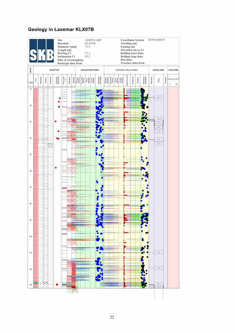
5 Results
5.1 CorelithologyThe 122.6 metres long interval of KLX07B, which was subjected to the comparative mapping, is dominated by a slightly K-feldspar porphyritic granite to quartz monzodiorite (rock code 501044). Other frequent rock types in the interval include fine-grained mafic rocks (rock code 505102), granite of variable grain-size (fine- to medium-grained, rock code 511058 and medium- to coarse-grained, rock code 501058) and pegmatite (rock code 501061). The most conspicuous of these occurrences is a ca 1.5 metre long interval of fine-grained mafic rock. None of the other occurrences exceed one metre in length, and the majority is less than one decimetre.
The K-feldspar phenocrysts in the porphyritic granite to quartz monzodiorite (501044) are typically euhedral to subhedral and range up to 1–1.5 centimetres in size. A noteworthy feature is that the rock generally is rich in macroscopically distinguishable sphene. The colour of the rock varieties ranges from greyish red to grey, often with a slight greenish tint due to very faint epidotization.
All mafic rocks (501044) are fine-grained and rather equigranular. The majority of the minor occurrences of these rocks are inferred to be enclaves.
Dykes and veins of fine- to medium-grained granite (511058) and medium- to coarse-grained granite (501058) are generally distinguished from the slightly K-feldspar porphyritic granite to quartz monzodiorite (501044) by the fact that they are more equigranilar and deficient in mafic minerals. Pegmatite and more coarse-grained varieties of granite are rather sparse relative to the more fine-grained varieties.
5.2 DuctilestructuresAll rocks in the mapped interval are rather massive and obviously post-kinematic. However, the slightly K-feldspar porphyritic granite to quartz monzodiorite exhibits generally a faint planar mineral fabric. This fabric is only distinguishable in the BIPS-image in one case where it has a registered orientation of 2�0°/65°.
Totally 1� narrow zones of more intense ductile and brittle-ductile deformation have been registered in the mapped interval of KLX07B. Except for a few minor zones in the interval 129.84–1�0.16 metres (adjusted length), all of them are limited to the upper 60 metres of the borehole. Two of the brittle-ductile deformation zones are 9 and 5 decimetres in length along the borehole, whereas none of the other zones exceed 2 decimetre. Most of the zones occurs in the slightly K-feldspar porphyritic granite to quartz monzodiorite (501044). There are, however, a few minor, brittle-ductile deformation zones in the fine- to medium-grained granite (511058), as well as in a fine-grained mafic rock (505102). The fracture sealing in the brittle part of the zones typically include chlorite, adularia, quartz, calcite and clay minerals. Most deformation zones have orientations that fall in the range 212–270°/2�–60°.

18
5.3 AlterationThe most common alteration type encountered in the mapped interval of KLX07B is varying degrees of oxidation or red pigmentation of feldspars by sub-microscopic hematite. It is generally intimately associated with more intensely fractured intervals. The majority of the oxidation is weak to medium in intensity. A more or less continuous interval of oxidation occurs in the 16 lowermost metres of the mapped interval. Fine-grained mafic rocks found in this, often highly oxidized section, are all variably chloritized. Argillization of faint to medium intensity occurs in the lowermost part of this interval (i.e. 129.5–1�1.1 metres).
Another frequent alteration is epidotization. It is normally too faint to be mapped with certainty. However, there are four minor sections (< 1 metre) where the intensity is inferred to be faint to weak.
5.4 Fractures5.4.1 Fracturefrequenciesandorientations
Excluding crush zones and sealed networks, the total number of open (broken fractures with aperture > 0), partly open (unbroken fractures with aperture > 0) and sealed fractures (broken and unbroken fractures with aperture = 0) registered during the comparative mapping of KLX07B amounts to 702, i.e. about 5.7 fractures/m. Of these are 561 visible in the BIPS-image. They can be separated in 276 open, 18 partly open and 408 sealed fractures. It should be emphasized that there is a certain degree of uncertainty in whether a fracture actually is open or sealed. Throughout the borehole, the frequency of open and sealed fractures varies rather coherently, with an increased number of open fractures in intervals with concentrations of sealed fractures (Appendix 1). Considering the fracture distribution along the mapped interval of KLX07B, there are three sections with somewhat increased fracture frequency: 9.6–4�, 86–9� and 116–1�2.2 metres adjusted length. Although parts of these intervals are intensely fractured, they have all rather vaguely defined margins.
The fracture orientations vary considerably throughout the mapped interval of KLX07B, though a stereographic projection in Figure 5-1 reveal at least one distinct fracture set. Poles to the fractures of this set forms a tight cluster, close to the centre, in the third quadrant of the stereogram. Thus, the fractures are generally striking NW-SE and dip gently towards northeast. Both sealed and open fractures are frequent in this set. In addition, there are a number of moderately dipping fractures with variable strikes. Interestingly, there are few vertical to sub-vertical fractures. Possibly, this might reflect a bias in data due to the fact that the borehole is drilled near-vertical. The maximum aperture of the fractures registered in the mapped interval of KLX07B is 4 millimetres.
Totally 1� narrow crush zones are found in the mapped interval of KLX07B: seven in the length interval 15–42 metres, and six in the length interval 109–1�2 metres. The fracture orientations within the crush zones are variable, but the vast majority dip gently (to moderately) towards northwest and northeast.
Three breccia zones and �1 sealed networks have been registered in the mapped interval of KLX07B. However, the distinction between breccia and sealed network is not straight forward, but zones with none or minor rotation of individual rock fragments has been mapped as sealed networks. All three breccias and about two thirds of the sealed networks are registered in the lowermost 18 metres of the mapped interval (i.e. 114–1�2). The orientation of the fractures within the networks is highly variable, but most fractures are gently dipping and a considerable amount belongs to the NW-SE trending set. The width of individual networks ranges up to about 1.5 metre.

19
5.4.2 Fracturemineralogy
Chlorite and/or calcite are found in more than 80% of the total number of the registered fractures in the mapped interval of KLX07B. Other infilling minerals, in order of decreas-ing abundance, include clay minerals, quartz, sub-microscopic hematite, adularia, pyrite, epidote, prehnite, sericite, laumontite and fluorite. A single calcite-bearing fracture with Fe-hydroxide coating occurs at 11.24 metres adjusted length. There are also 24 fractures that are virtually free from visible mineral coatings and oxidized walls. These are mostly open, and many of them were found to belong to the NW-SE trending set of gently dipping fractures.
Clay minerals almost always found in fractures inferred to be open. A considerable amount of these fractures are representatives of the roughly NW-SE trending set of gently dipping fractures. It is generally impossible to be more specific regarding the type of clay minerals.
Prehnite is more or less restricted to sealed fractures in fine-grained mafic rocks. Most of these fractures are rather thin (< 1 millimetre). The identification is therefore difficult and some of the light greenish mineral mapped as prehnite might be adularia or possibly epidote.
Most other minerals are typically associated with a calcite–chlorite assemblage, which for pyrite and hematite locally includes clay minerals and for epidote and adularia locally includes quartz. However, the presence of pyrite, hematite, epidote and adularia are largely mutually exclusive.
Figure 5-1. Lower hemisphere, equal-area stereographic projections showing the poles to all sealed (blue squares) and open (red squares) fractures in the adjusted length interval 9.6–132.2 metres of borehole KLX07B. The filled, black circle marks the orientation of the borehole axis of KLX07B.
Total Data : 562KLX07B

21
Appendix1
WellCADimageLegendforLaxemarKLX07B
Appendix: 1
22
Dateofcoremapping
CoordinateSystem RT90-RHB70
Length[m]
Title GEOLOGYINKLX07B
Elevation[m.a.s.l.]Diameter[mm] 76.0
Inclination[°] -85.2
Borehole KLX07BSite SIMPEVARP
Northing[m]Easting[m]
Appendix: 1
Fracturedatafrom
Bearing[°] 171.1
PlotDateDrillingStopDateDrillingStartDate
Rocktypedatafrom
1:500
DEP
TH.
TYP
E
Stru
ctur
e
Text
ure
Gra
insi
ze
Stru
ctur
eO
rient
atio
n
Roc
k Ty
pe<
1m
Alte
ratio
n
Inte
nsity
ROCKTYPE
Prim
ary
Min
eral
Sec
onda
ryM
iner
al
Third
Min
eral
Four
thM
iner
al
Alte
ratio
nO
rient
atio
n
SEALEDFRACTURES
Prim
ary
Min
eral
Sec
onda
ryM
iner
al
Third
Min
eral
Four
thM
iner
al
Rou
ghne
ss
Sur
face
Alte
ratio
nO
rient
atio
n
Ape
rture
(mm
)
NATURAL FRACTURES
Alte
ratio
n
Pie
ce
Cor
elos
s
CRUSHZONE
Frequency (fr/m)
0 20
FRACTURE
10
20
30
40
50
60
70
80
90
100
110
120
20.0
15.0
10.0
8.0
6.0
6.0
8.0
6.0
5.0
Page 1130 20.0
20 0
Page 2
GeologyinLaxemarKLX07B
130 20.0
20 0
Page 2

2�
Appendix2
BoreholediametersHoleDiamT–Drilling:BoreholediameterKLX07B,2005‑05‑2315:00:00–2005‑06‑0308:00:00(0.000–200.130m)
SubSecup(m)
SubSeclow(m)
HoleDiam(m)
Comment
0.000 9.640 0.096 HQ (rymning )
9.640 200.130 0.076 Corac N/3
Printout from SICADA 2005-07-06 11:02:00.

25
Appendix3
DownholedeviationmeasurementsMagneticAccDevT–MagneticaccelerometerdeviationmeasurementKLX07B,2005‑07‑0912:30:00–2005‑07‑0914:00:00(0.000–198.000m)
Bhlen(m)
MagneticBearing(degrees)
Dip(degrees)
Northing(m)
Easting(m)
Elevation(m)
Locala(m)
Localb(m)
Localc(m)
0.00 170.4 –85.2 6366753.140 1549206.760 18.380
3.00 170.5 –85.2 6366752.890 1549206.800 15.390
6.00 169.3 –85.1 6366752.640 1549206.840 12.400
9.00 171.1 –85.2 6366752.390 1549206.890 9.410
12.00 170.8 –85.2 6366752.140 1549206.930 6.420
15.00 169.8 –85.2 6366751.890 1549206.970 3.430
18.00 170.3 –85.2 6366751.640 1549207.010 0.440
21.00 170.4 –85.2 6366751.390 1549207.060 –2.550
24.00 169.8 –85.2 6366751.150 1549207.100 –5.530
27.00 170.1 –85.2 6366750.900 1549207.140 –8.520
30.00 170.1 –85.2 6366750.650 1549207.190 –11.510
33.00 170.5 –85.1 6366750.400 1549207.230 –14.500
36.00 169.1 –85.1 6366750.140 1549207.280 –17.490
39.00 169.8 –85.0 6366749.890 1549207.320 –20.480
42.00 169.7 –85.0 6366749.630 1549207.370 –23.470
45.00 170.6 –85.0 6366749.370 1549207.410 –26.460
48.00 170.2 –85.0 6366749.110 1549207.460 –29.450
51.00 172.0 –84.9 6366748.850 1549207.500 –32.430
54.00 170.7 –85.0 6366748.590 1549207.540 –35.420
57.00 170.3 –84.9 6366748.330 1549207.580 –38.410
60.00 171.6 –84.9 6366748.070 1549207.620 –41.400
63.00 171.7 –85.1 6366747.810 1549207.660 –44.390
66.00 170.4 –84.9 6366747.550 1549207.700 –47.380
69.00 171.0 –84.9 6366747.290 1549207.750 –50.360
72.00 172.3 –85.0 6366747.020 1549207.780 –53.350
75.00 171.0 –85.0 6366746.770 1549207.820 –56.340
78.00 172.4 –84.9 6366746.510 1549207.860 –59.330
81.00 174.7 –85.0 6366746.240 1549207.890 –62.320
84.00 171.4 –85.0 6366745.980 1549207.920 –65.310
87.00 171.9 –85.1 6366745.720 1549207.960 –68.300
90.00 172.4 –85.0 6366745.470 1549208.000 –71.280
93.00 171.1 –85.1 6366745.210 1549208.030 –74.270
96.00 171.5 –85.0 6366744.960 1549208.070 –77.260
99.00 171.4 –85.0 6366744.700 1549208.110 –80.250
102.00 171.4 –85.0 6366744.440 1549208.150 –83.240
105.00 171.6 –85.0 6366744.180 1549208.190 –86.230
108.00 171.4 –85.0 6366743.920 1549208.230 –89.220
111.00 172.1 –85.2 6366743.670 1549208.260 –92.200

26
114.00 173.2 –85.1 6366743.410 1549208.300 –95.190
117.00 171.2 –85.2 6366743.160 1549208.330 –98.180
120.00 170.9 –85.1 6366742.910 1549208.370 –101.170
123.00 170.9 –85.0 6366742.660 1549208.410 –104.160
126.00 171.3 –85.0 6366742.400 1549208.450 –107.150
129.00 171.5 –85.2 6366742.150 1549208.490 –110.140
132.00 171.7 –85.0 6366741.890 1549208.530 –113.130
135.00 172.0 –85.0 6366741.630 1549208.560 –116.120
138.00 172.6 –85.0 6366741.370 1549208.600 –119.110
141.00 172.7 –85.0 6366741.110 1549208.630 –122.090
144.00 174.2 –85.0 6366740.850 1549208.660 –125.080
147.00 173.6 –85.0 6366740.590 1549208.690 –128.070
150.00 173.2 –85.0 6366740.330 1549208.720 –131.060
153.00 172.9 –84.9 6366740.070 1549208.750 –134.050
156.00 171.2 –84.9 6366739.810 1549208.790 –137.040
159.00 171.1 –84.9 6366739.540 1549208.830 –140.020
162.00 171.0 –84.8 6366739.280 1549208.870 –143.010
165.00 171.1 –84.8 6366739.010 1549208.910 –146.000
168.00 172.0 –84.8 6366738.740 1549208.950 –148.990
171.00 172.6 –84.8 6366738.470 1549208.990 –151.970
174.00 172.8 –84.8 6366738.200 1549209.030 –154.960
177.00 172.0 –84.8 6366737.930 1549209.060 –157.950
180.00 173.4 –84.8 6366737.660 1549209.100 –160.940
183.00 175.0 –84.8 6366737.380 1549209.120 –163.920
186.00 175.7 –84.9 6366737.120 1549209.150 –166.910
189.00 173.6 –84.8 6366736.850 1549209.170 –169.900
192.00 172.4 –84.8 6366736.580 1549209.200 –172.890
195.00 175.7 –84.8 6366736.310 1549209.230 –175.880
198.00 173.5 –84.8 6366736.040 1549209.260 –178.860
Printout from SICADA 2005-08-08 17:02:38.