Embed Size (px)
Citation preview
Portland State University Portland State University
PDXScholar PDXScholar
Center for Urban Studies Publications and Reports Center for Urban Studies
6-1985
Report on Feasibility of A Geographic Information Report on Feasibility of A Geographic Information
System for The Central City Citizen Planning System for The Central City Citizen Planning
Committees Committees
Kenneth Dueker Portland State University
George Mason Portland State University
Follow this and additional works at: https://pdxscholar.library.pdx.edu/cus_pubs
Part of the Geographic Information Sciences Commons, and the Urban Studies and Planning
Commons
Let us know how access to this document benefits you.
Citation Details Citation Details Dueker, Kenneth and Mason, George, "Report on Feasibility of A Geographic Information System for The Central City Citizen Planning Committees" (1985). Center for Urban Studies Publications and Reports. 72. https://pdxscholar.library.pdx.edu/cus_pubs/72
This Report is brought to you for free and open access. It has been accepted for inclusion in Center for Urban Studies Publications and Reports by an authorized administrator of PDXScholar. Please contact us if we can make this document more accessible: [email protected].
REPORT ON THE FEASIBILITY
OF
A GEOGRAPHIC INFORMATION SYSTEM
FOR THE
CENTRAL CITY CITIZEN PLANNING COMMITTEES
A Report to Dean Smith, Director
Central City Planning Project
June 1985
By
Dr. KennethJ. Dueker
and
George L. Mason
The Center for Urban Studies
Portland State University
P.O. Box 751
Portland, OR 97207
Page 1 PSU/GIS Report June 9, 1985
I NTROOUCT I ON In September 1984 PSU was contracted to demonstrate the utility of an interactive graphic d6t6 b6se system. A project W6S done using LANDTRAK* to determine which records from the tox roll were inside the Centrol City Pl6nning Are6. This inform6tion provides 6 st6rting point for o porcel b6sed inform6tion system for the Central City Planning Proj-ect. This report consists of 6 design for 6 geographic inform6tion system for the Central City Pl6nning Areo thot moy serve os o prototype for o bro6der geogrophi c inf ormot ion system for the City.
Computer Services h6s been provided o doto t6pe cont6ining geo-coded porcel numbers, which will be useful in selecting the A&T informotion for the Offi ce Of Housing Policy's controct with the Central City Plonning Stoff. The LANDTRAK Softw6re 6V6il6ble through Portl6nd St6te's Center for Urb6n Stu di es oi ded 1 n producing thot t6pe. '-··
Records from the A& T t6x roll within the QU6rter sections in ond oround the Centrol City Plonning Areo were obt6ined from Computer Services. f n these 32 QU6rter sections there were 12,000 porcel records. By digitizing the bound6ries of the Central City Plonning Area, as well as the sub6reas within the Central City Phm, it was possible to select the 3,500 p6rcels that are within the Centrol City. The listing included the suboreo, the census troct, block number ond DIME record number ossocioted with eoch p6rcel's tox account number. It is now possible to select the tox informotion from the current tox roll by mot chi ng the 1ox occount number.
The process of creoting the listing Of porcel occount numbers within the Centrol City Plonn1ng Areo wos occomplished by oddress motching. The 12,000 records from the MT rolls were to sent to Son Diego: It took approximately one ond a ho 1f hours, to re6d the tope and run it through the three progroms
*Londtrok is o softwore system developed by Criterion Inc., of S6n Diego, Calif omia. PSU as 6ccess to the system for educ6tion and service applic6tions.
I" •.
I.
Poge2 PSU/GIS Report June 9, 1985
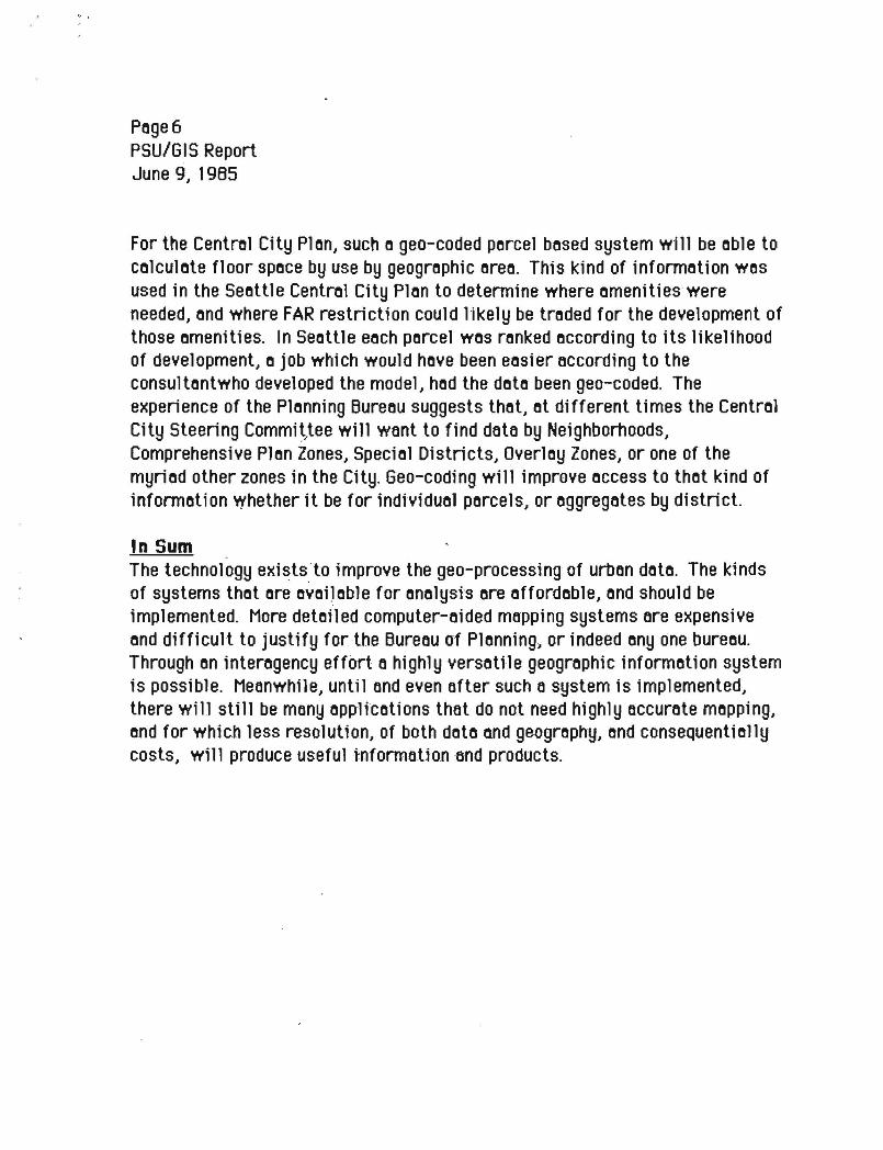
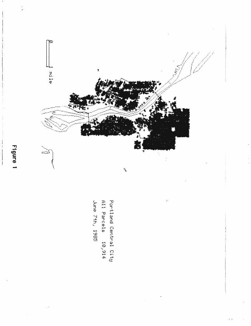
necess8ry to ·8dm8tch· (m8tch 8ddresses to x 8nd y coordinotes 8nd the census geography) the records. Ten thous8nd records were 8dmatched. Two thoustmd records did not h8ve addresses attoched to the t8x 8Ccount numbers. These are on a file and have been listed with the legal description and will have to be m8tched manually. The ten thousand records were loaded into LANDTRAK in a ·batch job· which took about four hours. (See Figure One) Once loaded, it took about five minutes to select the central city plan area, and ask for a list of the parcels in th8t area. "(see Figure Two) The list included the census tract, block number, and DIME record number for each parcel. This file was copied to tape, and sent back_ to Computer Services. In less than a person-day's worth of time 1t wos possible to select the records within the central city plan. The most time intensive part of the process was the first loading of the information. Once that was done, pulling information by geoyraphic area is fast and can be done tnterJacuvely. Ne~erthe-less, the job took longer in elapsed time. If LANDTRAK were available on the City's computer system, it would have been far easier to do the job in""'.bouse rather than remotely.
A geo-based information system should be developed in-house. Much time was lost in the process of file tran-sfers 6ntl in the inefficiency of using two sy:stems, both o.f which have . a~nistrators with differing priorities as well as many usars. The productivttY/planning staff and citizen planning groups could.be greatly enhanced by such o system. A geo-based system would help inventor] and track downtown housing and for other areas that might be singled out for special attention currently or·in the future. Urban Renewal Districts, Local Improvement Districts, and Housing and Community Development target areas, typi ca 11-y need a list of a 11 the properties within these boundaries. These would be easy to· produce. Staff could do the work interactively and not need to depend on Computer Services once the job becomes routine,, Such 1 i sts used in combinetton with 8ppropriate models, would eid in the study of current or future impacts of public 1nvestment, tax increment financing or special ordinances, with greater ease than is presently possible.
Interactive graphics 'seems to be a necessary ingredient to make address matching and other geo-based processing really usable to the Bureaus. A
,, .
P6ge3 PSU/G IS Report June 9, 1965
system such os LANDTRAK ond o user oriented systems onolyst ore needed to 1mplement the technology.
Through this project, much insight hos been goined into the problems of o city wide geo-bosed system. Portlond's unique form of bureou structure presents mony problems in developing o coordin6ted system, however mony of the pieces of o geo-bosed system ore in ploce. Computer Services, hos consideroble experience with the DIME flle ond geo-coding. With o smoll omount of c-oordin6ted effort th~ bure6us c6n utilize this experience 6nd begin to "tie" f ndividuol doto boses together into o city wide system, with the "whole" being greoter thon the sum of the ports. Nevertheless, the current issue is, how might the geo-code~ doto ond the interoctive grophic onolysi-s system be of use to the Centrol City Plon Steering Committee, os well os other bureous. And whot ore the costs ond benefits?
An Information System Approach An informotion system is os complex os the decisionmoking system it supports. An inf ormot ion system 1i ke ony other pub 1i c progrom or foci 1i ty needs to hove o development plon. Such o plon must hove long-ronge go61s, short term objectives ond oppropriote evoluotion procedures. A p16n for 6n informotion system must serve ond be supported by oll involved. The support for on informotion system depends on results . . It needs to be rel'ioble cmd hove o quick poy bock period, in terms of production or ti me soved in doy-to-day c1 ty business, such os doto extroction for reports ond studies. The City con no longer offord to collect doto independently for e~h plonning project, or progrom element. 06to collecHon 1s on ongoing process.
Yet, o gool to ocquire the "ultimote informotion mochine" is not feosible, ot leost in one gi6nt step. When thinking of computerized urb6n d6t6, one often thinks of o muti-m111ion doll or detai-led mopping system tok1ng yeors to implement, with o concomitont bottle of who controls it 6nd who mointoins it. With these lorge costs the question becomes, which bureous con offord it? The onswer is those bureous with lorge focility monogement responsibilities, ond o constont need for detoiled, lorge scole mops, such os Public Works, ond the Woter Bureou. Meonwhile, less costly systems ore possible ond useful,
Poge4 PSU/G IS Report June 9, 1985
porticulorly for the Plonning Bureou, os well os other bureous thot must prepore reports obout geogrophic oreos, hold heor1ngs or locote porcel informotion.
An I ncrementn 1 Design Another woy is suggested t-0 built on informotion system, incrementolly, os eoch piece justifies itself. Such on opprooch requires o cleor set of goo ls ond object i Yes, cooperot i ve 1 y odopted, communi cot 1 on omong port i ci poll ng bureous, ond stoff to ommge t.osks ond coordinote octiv1ty. The stoff role would be to design system elements to support current opplicotions. The strategy would be to develop on interoctive geo-bosed system, with ropid occess to on-line inf ormot ion.
First, build _from on oreo of strength, the city's experience with using doto from the tox roll ond the_Dl_ME file. Much city effort ond time hos been spent orgonizing records with DIME record numbers ond identifiers. Augmentotion with o LANDTRAK-type system would ollow for interactive access to dato, with sf mul toneous disp 1 oy of ge.ogrophi co 11 y co 11 oted inf ormot ion. The spot i o 1 occurocy oJ this type of system is suitoble for most plonning octivities. It allows for the approximate location of parcels. It is not meont to produce mops occurote enough for engineering or detailed site planning, however.
More detaile·d mopping systems require o moss·ive up-front looding of primary doto ond should be the responsibility_ of the bureou·s hoving foc'ility monogement tasks. Eoch would create it's own loyer of doto, e.g., water, tronsportotion, sewers, for inclusion in on eventuol mulh-purpose ~odostre system. Most bureous would benefit from both types of systems. One should not preclude the other. The efforts should be coordinated, to moke the "whole" effort more than the sum of seporote dot~ bose efforts, in planning, buildings, business licenses, ond the police informotion system, to nome o few.
The rotionole for on incremental strategy beginning with DIME file level of detoil ond occurocy is lorgely one of cost ond time. The DIME bosed system fromework exists, it con be extended too porcel level using the ADMATCH program ond using opproximote porcel centroids for information ot the porcel level. Such o system would cost obout $100,000 to implement, ond $40,000 per
Poge5 PSU/615 Report June 9, 1985
yeor to mointoin. This cost would include o system odministrotor to moke it work. This system could be up ond running within o one yeor time frome, becouse 1t requires little doto input. There ore mony immedi6te oppllcotions to justify the system. The initiol cost is minimol becouse o new computer is not needed immediotely. The City's VAX is quite suitoble, until such time os it becomes overl ooded.
In the long run o more detoiled ond powerful mopping system will be needed, 6nd steps to thot end ,should begfn. Vet oll plonnfng octivft1es ond fnformotion needs connot woit for the ultimote system. Engineering/ossessor mop occurocy will require on improved system for geodetic control ond bose mop coordinotion .. This will be expensive. In oddition, this detoiled type of system includes the copture, storoge, ond processing of o much lorger volume of doto. I nsteod of 1 point per porce 1 there wi 1l be ot 1 eost four or even more points per p6rcel, gre6tly incre6sing digitizing 6nd d6t6 storoge costs. Typic6lly, this kind of system will cost. o million doll ors for hon:twore ond soft wore, ond $200,000 per yeor for mointenonce ond monpower. A geogrophlc informotion system with full mopping copobility would toke four to six ye ors to implement. A dedicoted computer would be needed up-front, ond the system will not be reody to use for current projects.
The Stote of Oregon ond Multnomoh County ore engoged in o process of designing o codostrol loyer (o porcel mop) to serve os o bose mop for Multnomoh County. Rother thon duphcote this eHort, the City should toke od:Yontoge of the digitol bo.se mop ond creote loyers of doto, thot spotiolly register. Hence the City's own loyers of doto, i.e., sewers, woter, buildings, will relote to eoch other ond other ogencies, i.e., gos, electric, ossessors.
Aoolications There is no doubt t.hot geo-coded d6t6 is useful. Computer Services h6s recently used the DIME file to check utility poyments ond ·found· severnl million doll or inf ees owed to the city. However, whot is needed is utility soft wore to oid mointenonce of the DIME file interoctively ond grnphicolly ond to relote records to polygons (oreos, districts, zones) so thot doto con be selected by geogrogh'ic oreos.
Poge6 PSU/GIS Report June 9, 1985
For the Central City Plon, such o geo-coded porcel bosed system will be oble to colculote floor spoce by use by geogrophic oreo. This kind of inf ormotion wos used in the Seottle Centrol City Plon to determine where omenities were needed, ond where FAR restriction could likely be troded for the development of those omenities. In Seottle eoch porcel wos ronked occording to its likelihood of development, o job which would hove been eosier occording to the consultontwho developed the model, hod the doto been geo-coded. The experience of the Plonning Bureou suggests thot, ot different times the Centrol City Steering Commit,tee will want to find data by Neighborhoods, Comprehensive Plon Zones, Speciol Districts, Overloy Zones, or one of the myriod other zones in the City. Geo-coding will improve occess to thot kind of informotion whether 1t be for individuol porcels, or oggregotes by district.
In Sum The technology exists. to improve the geo-processing of urbon doto. The kinds of systems thot ore ovoiJoble for onolysi·s ore offordoble, ond should be implemented. More detoiled computer-oided mopping systems ore expensive ond difficult to justify for the Bureou of Plonning., or indeed ony one bureou. Through on interogency effort o highly versoHle geogrophic informotion system is possible. Meonwhile, until ond even ofter such o system is implemented, there will stHl be mony oppHcotions that do not need highly occurote mopping, ond for which less resolution, of both doto ond geogrophy, ond consequentiolly costs, will produce useful tnf ormot.ion -and products.
"Tl -(Q c ~ -
f J) '1J ;;:-:5
..... (I ..... ;.
.•'
111 ,--+-'1J .....
--.J Ii.• U.1 .,... ;. :::; ~ 1-i ~
.... •ti ..... n - I/I •ti •.i)
..,. -· (Q ,--+-01 ;.
...... U.1 Q .....
·~
'i> n ...... ..... .p. _.....
(,!;;.
0 0 0 I~ Q I~ Q e:.1 ISi e:.1 Q Q Q Q . . . . . . . e:.1 [{) e:.1 If) Q Q Q (.{') r ...... e:.1 (lJ Q ·~ Q - (\J •)J (') (lJ •J)
...-c ...-c
I I
0 0 e:.1 I~ Q ·~ Q e:.1 ISi e:.1 0 Q Q ISi . . . . . . . e:.1 - •.J) ...-c \(I ...-c ...-c
I[) r ...... ·~ (lJ I~ Q - (lJ (IJ 1;>") (IJ ...-c
.. 00•11•••
J) _, ·rl
u .......
11) L ~
~ IJ.1 u -;::; ~" ~ IT) 11) iJ.•
....... L _,
IT) L -8 0 -· CL (I)
If) ro er\ ...-c
..... s:.. +> r--
tJJ ~ :::; -)
I")
Q)
.. :
L. .i. :J ':. C) -.....
1
f
, .
°'S) I"-+-' ('lJ ..... "¢
Ll ~.
~ ...... '°!' 0... LO :... +-' r....:i 00 .- r...;i r:s~ ,_
iJ.1 """' Ll i: ....... "" ~ ~
. :... ill ...,:-., ,,, ...... r~
...... a.• +-' ':-' 11.• ~ :... c
/ Q i"Q .::-. 0... 0... ) .