Embed Size (px)
DESCRIPTION
Harry Tzalas's report about the shoreline of ancient Alexandria.
Citation preview
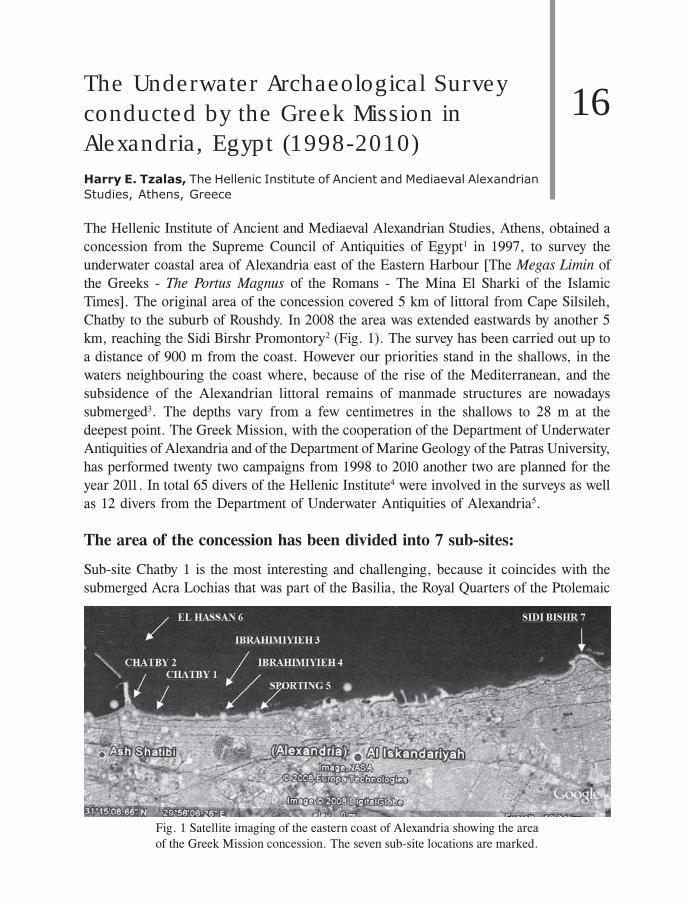
The Underwater Archaeological Surveyconducted by the Greek Mission inAlexandria, Egypt (1998-2010)Harry E. Tzalas, The Hellenic Institute of Ancient and Mediaeval Alexandrian
Studies, Athens, Greece
The Hellenic Institute of Ancient and Mediaeval Alexandrian Studies, Athens, obtained a
concession from the Supreme Council of Antiquities of Egypt1 in 1997, to survey the
underwater coastal area of Alexandria east of the Eastern Harbour [The Megas Limin of
the Greeks - The Portus Magnus of the Romans - The Mina El Sharki of the Islamic
Times]. The original area of the concession covered 5 km of littoral from Cape Silsileh,
Chatby to the suburb of Roushdy. In 2008 the area was extended eastwards by another 5
km, reaching the Sidi Birshr Promontory2 (Fig. 1). The survey has been carried out up to
a distance of 900 m from the coast. However our priorities stand in the shallows, in the
waters neighbouring the coast where, because of the rise of the Mediterranean, and the
subsidence of the Alexandrian littoral remains of manmade structures are nowadays
submerged3. The depths vary from a few centimetres in the shallows to 28 m at the
deepest point. The Greek Mission, with the cooperation of the Department of Underwater
Antiquities of Alexandria and of the Department of Marine Geology of the Patras University,
has performed twenty two campaigns from 1998 to 2010 another two are planned for the
year 2011. In total 65 divers of the Hellenic Institute4 were involved in the surveys as well
as 12 divers from the Department of Underwater Antiquities of Alexandria5.
The area of the concession has been divided into 7 sub-sites:
Sub-site Chatby 1 is the most interesting and challenging, because it coincides with the
submerged Acra Lochias that was part of the Basilia, the Royal Quarters of the Ptolemaic
Fig. 1 Satellite imaging of the eastern coast of Alexandria showing the area
of the Greek Mission concession. The seven sub-site locations are marked.
16
SHIPWRECKS AROUND THE WORLD: REVELATIONS OF THE PAST348
Period and has revealed a varied and large number of artefacts. Sub-site Chatby 2 bears
some remains that are attributed to the Martyrium of St. Marc. Besides surveying in the
sea area, we also opened some trenches on the beach that revealed a large amount of
pottery sherds all datable to the 5th and 6th centuries AD. Sub-site Ibrahimieh 3 consists
of a large reef, where a great number of mediaeval stone anchors have been found [over
50 anchors] as well as the lead components of a very large Late Hellenistic or Early
Roman composite anchor. Sub-site Ibrahimieh 4 revealed the remains of a large stone
quarry co-existing with some rock-cut burials. Unfortunately, after our preliminary survey
the area was completely reclaimed and obliterated because of the widening of the Corniche
road. At Sub-site Sporting 5 the remains of a large Necropolis in the shallows has been
only partially covered by the Coastal Road widening and the dropping of concrete blocks,
but our survey continues as remains of structures in deeper waters have been recently
found. Sub-site El-Hassan 6 is a reef located at some 500 m North East of the eastern
entrance of the Eastern Port, which was in ancient and mediaeval times a hazard to
navigation. A large number of amphoras and pottery sherds were found witnessing to the
presence of several ancient shipwrecks most dating to late antiquity. At Sub-site Sidi
Bishr 7 the remains of what certainly was a large Necropolis were traced. The whole
coastal area of this necropolis was used as a stone quarry at an undetermined period; what
is preserved above sea level is a small portion of a large hypogeum with a semi-submerged
corridor at the Sidi Bishr promontory as well as remains of burial on the islet of Gezira
Gabr El Khour. A vast area on the sea floor shows marks of quarrying activities and is
scattered with numerous stone blocks. A very brief description of what was found on each
of the above mentioned sub-sites is given hereunder pending the final publication.
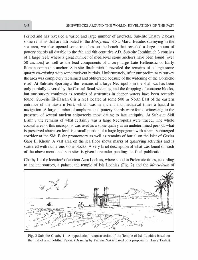
Chatby 1 is the location6 of ancient Acra Lochias, where stood in Ptolemaic times, according
to ancient sources, a palace, the temple of Isis Lochias (Fig. 2) and the Mausoleum of
Fig. 2 Sub-site Chatby 1: A hypothetical reconstruction of the Temple of Isis Lochias based on
the find of a monolithic Pylon. (Drawing by Yiannis Nakas based on a proposal of Harry Tzalas)
THE UNDERWATER ARCHAEOLOGICAL SURVEY CONDUCTED BY THE GREEK ... 349
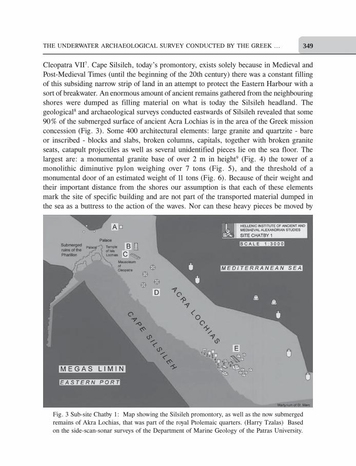
Cleopatra VII7. Cape Silsileh, today’s promontory, exists solely because in Medieval and
Post-Medieval Times (until the beginning of the 20th century) there was a constant filling
of this subsiding narrow strip of land in an attempt to protect the Eastern Harbour with a
sort of breakwater. An enormous amount of ancient remains gathered from the neighbouring
shores were dumped as filling material on what is today the Silsileh headland. The
geological8 and archaeological surveys conducted eastwards of Silsileh revealed that some
90% of the submerged surface of ancient Acra Lochias is in the area of the Greek mission
concession (Fig. 3). Some 400 architectural elements: large granite and quartzite - bare
or inscribed - blocks and slabs, broken columns, capitals, together with broken granite
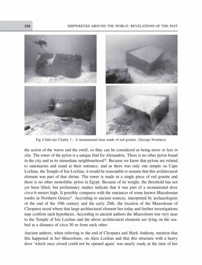
seats, catapult projectiles as well as several unidentified pieces lie on the sea floor. The
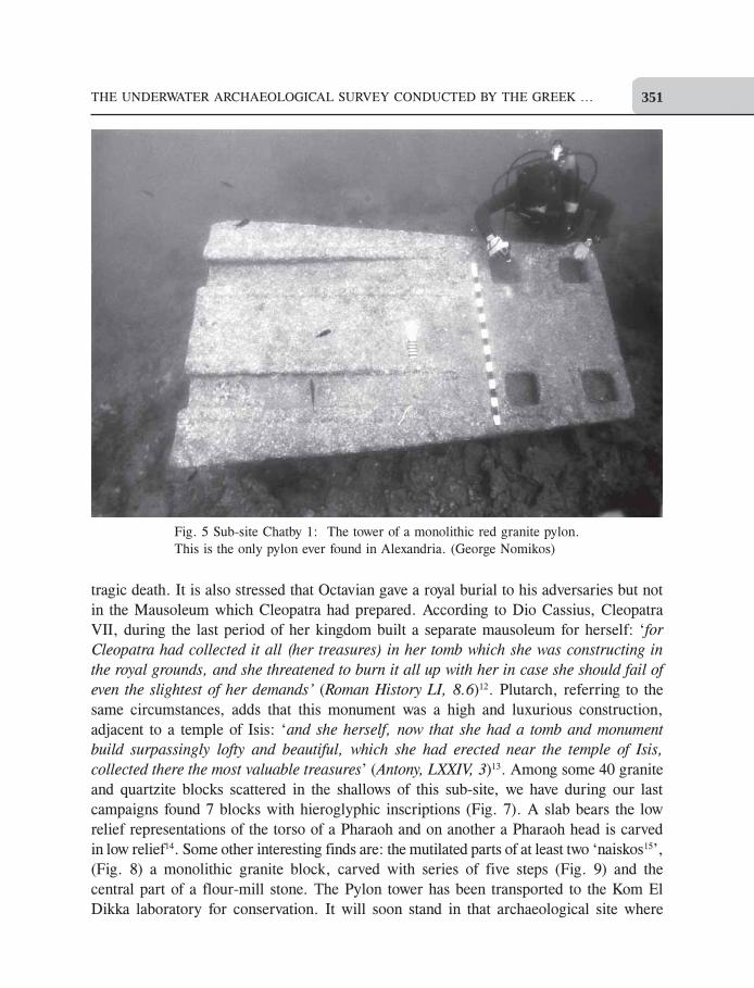
largest are: a monumental granite base of over 2 m in height9 (Fig. 4) the tower of a
monolithic diminutive pylon weighing over 7 tons (Fig. 5), and the threshold of a
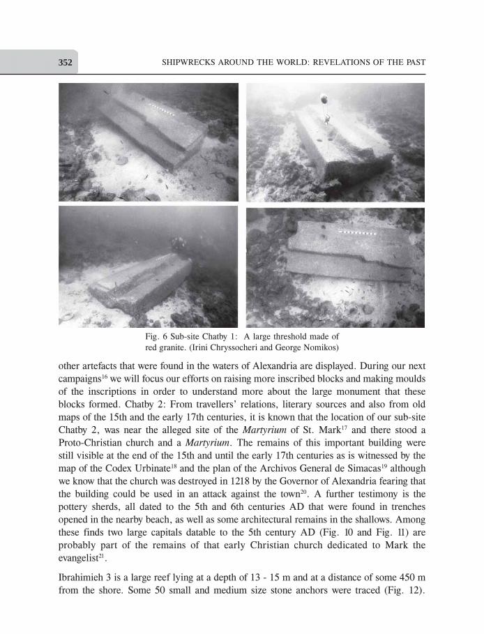
monumental door of an estimated weight of 11 tons (Fig. 6). Because of their weight and
their important distance from the shores our assumption is that each of these elements
mark the site of specific building and are not part of the transported material dumped in
the sea as a buttress to the action of the waves. Nor can these heavy pieces be moved by
Fig. 3 Sub-site Chatby 1: Map showing the Silsileh promontory, as well as the now submerged
remains of Akra Lochias, that was part of the royal Ptolemaic quarters. (Harry Tzalas) Based
on the side-scan-sonar surveys of the Department of Marine Geology of the Patras University.
SHIPWRECKS AROUND THE WORLD: REVELATIONS OF THE PAST350
the action of the waves and the swell, so they can be considered as being more or less in
situ. The tower of the pylon is a unique find for Alexandria. There is no other pylon found
in the city and in its immediate neighbourhood10. Because we know that pylons are related
to sanctuaries and stand at their entrance, and as there was only one temple on Cape
Lochias, the Temple of Isis Lochias, it would be reasonable to assume that this architectural
element was part of that shrine. The tower is made in a single piece of red granite and
there is no other monolithic pylon in Egypt. Because of its weight, the threshold has not
yet been lifted, but preliminary studies indicate that it was part of a monumental door
circa 6 meters high. It possibly compares with the entrances of some known Macedonian
tombs in Northern Greece11. According to ancient sources, interpreted by archaeologists
of the end of the 19th century and the early 20th, the location of the Mausoleum of
Cleopatra stood where that large architectural element lies today and further investigations
may confirm such hypothesis. According to ancient authors the Mausoleum was very near
to the Temple of Isis Lochias and the above architectural elements are lying on the sea-
bed at a distance of circa 50 m from each other.
Ancient authors, when referring to the end of Cleopatra and Mark Anthony, mention that
this happened in her Mausoleum, on Akra Lochias and that this structure with a heavy
door ‘which once closed could not be opened again’ was nearly ready at the time of her
Fig 4 Sub-site Chatby 1: A monumental base made of red granite. (George Nomikos)
THE UNDERWATER ARCHAEOLOGICAL SURVEY CONDUCTED BY THE GREEK ... 351
tragic death. It is also stressed that Octavian gave a royal burial to his adversaries but not
in the Mausoleum which Cleopatra had prepared. According to Dio Cassius, Cleopatra
VII, during the last period of her kingdom built a separate mausoleum for herself: ‘for
Cleopatra had collected it all (her treasures) in her tomb which she was constructing in
the royal grounds, and she threatened to burn it all up with her in case she should fail of
even the slightest of her demands’ (Roman History LI, 8.6)12. Plutarch, referring to the
same circumstances, adds that this monument was a high and luxurious construction,
adjacent to a temple of Isis: ‘and she herself, now that she had a tomb and monument
build surpassingly lofty and beautiful, which she had erected near the temple of Isis,
collected there the most valuable treasures’ (Antony, LXXIV, 3)13. Among some 40 granite
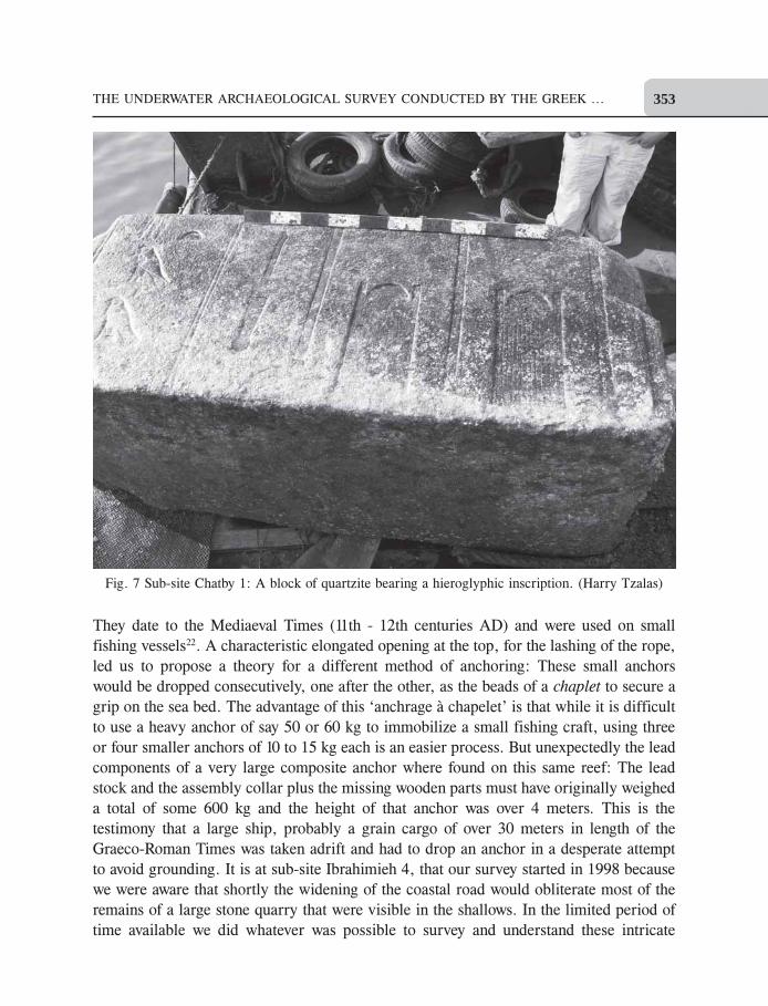
and quartzite blocks scattered in the shallows of this sub-site, we have during our last
campaigns found 7 blocks with hieroglyphic inscriptions (Fig. 7). A slab bears the low
relief representations of the torso of a Pharaoh and on another a Pharaoh head is carved
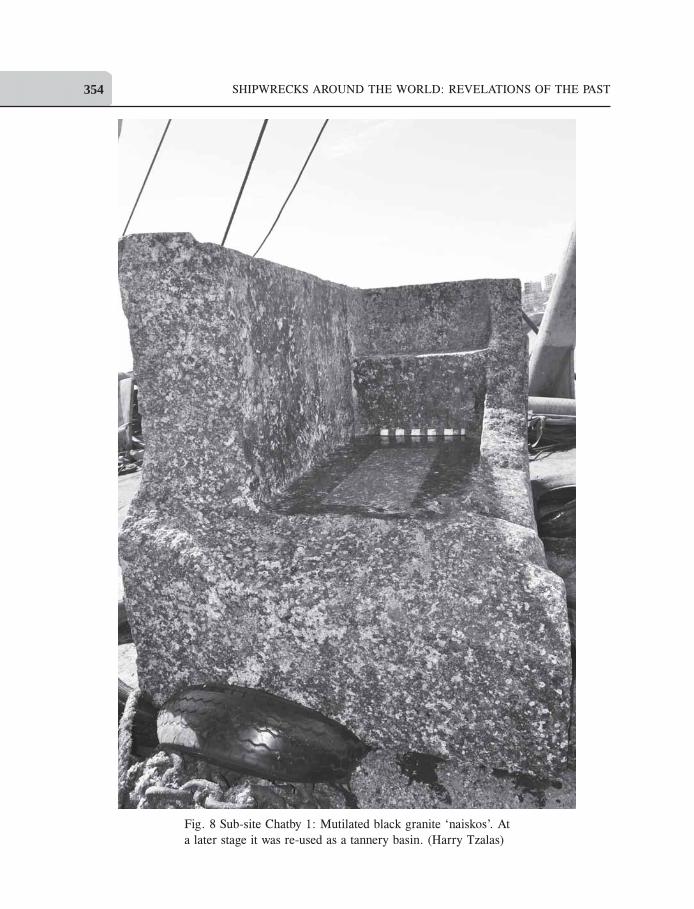
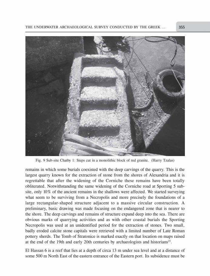
in low relief14. Some other interesting finds are: the mutilated parts of at least two ‘naiskos15’,
(Fig. 8) a monolithic granite block, carved with series of five steps (Fig. 9) and the
central part of a flour-mill stone. The Pylon tower has been transported to the Kom El
Dikka laboratory for conservation. It will soon stand in that archaeological site where
Fig. 5 Sub-site Chatby 1: The tower of a monolithic red granite pylon.
This is the only pylon ever found in Alexandria. (George Nomikos)
SHIPWRECKS AROUND THE WORLD: REVELATIONS OF THE PAST352
other artefacts that were found in the waters of Alexandria are displayed. During our next
campaigns16 we will focus our efforts on raising more inscribed blocks and making moulds
of the inscriptions in order to understand more about the large monument that these
blocks formed. Chatby 2: From travellers’ relations, literary sources and also from old
maps of the 15th and the early 17th centuries, it is known that the location of our sub-site
Chatby 2, was near the alleged site of the Martyrium of St. Mark17 and there stood a
Proto-Christian church and a Martyrium. The remains of this important building were
still visible at the end of the 15th and until the early 17th centuries as is witnessed by the
map of the Codex Urbinate18 and the plan of the Archivos General de Simacas19 although
we know that the church was destroyed in 1218 by the Governor of Alexandria fearing that
the building could be used in an attack against the town20. A further testimony is the
pottery sherds, all dated to the 5th and 6th centuries AD that were found in trenches
opened in the nearby beach, as well as some architectural remains in the shallows. Among
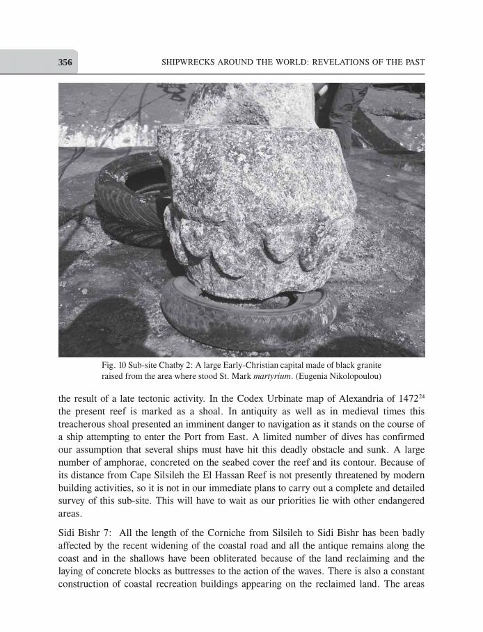
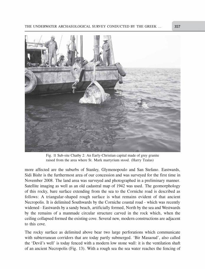
these finds two large capitals datable to the 5th century AD (Fig. 10 and Fig. 11) are
probably part of the remains of that early Christian church dedicated to Mark the
evangelist21.
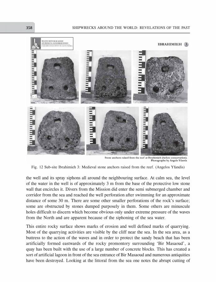
Ibrahimieh 3 is a large reef lying at a depth of 13 - 15 m and at a distance of some 450 m
from the shore. Some 50 small and medium size stone anchors were traced (Fig. 12).
Fig. 6 Sub-site Chatby 1: A large threshold made of
red granite. (Irini Chryssocheri and George Nomikos)
THE UNDERWATER ARCHAEOLOGICAL SURVEY CONDUCTED BY THE GREEK ... 353
They date to the Mediaeval Times (11th - 12th centuries AD) and were used on small
fishing vessels22. A characteristic elongated opening at the top, for the lashing of the rope,
led us to propose a theory for a different method of anchoring: These small anchors
would be dropped consecutively, one after the other, as the beads of a chaplet to secure a
grip on the sea bed. The advantage of this ‘anchrage à chapelet’ is that while it is difficult
to use a heavy anchor of say 50 or 60 kg to immobilize a small fishing craft, using three
or four smaller anchors of 10 to 15 kg each is an easier process. But unexpectedly the lead
components of a very large composite anchor where found on this same reef: The lead
stock and the assembly collar plus the missing wooden parts must have originally weighed
a total of some 600 kg and the height of that anchor was over 4 meters. This is the
testimony that a large ship, probably a grain cargo of over 30 meters in length of the
Graeco-Roman Times was taken adrift and had to drop an anchor in a desperate attempt
to avoid grounding. It is at sub-site Ibrahimieh 4, that our survey started in 1998 because
we were aware that shortly the widening of the coastal road would obliterate most of the
remains of a large stone quarry that were visible in the shallows. In the limited period of
time available we did whatever was possible to survey and understand these intricate
Fig. 7 Sub-site Chatby 1: A block of quartzite bearing a hieroglyphic inscription. (Harry Tzalas)
SHIPWRECKS AROUND THE WORLD: REVELATIONS OF THE PAST354
Fig. 8 Sub-site Chatby 1: Mutilated black granite ‘naiskos’. At
a later stage it was re-used as a tannery basin. (Harry Tzalas)
THE UNDERWATER ARCHAEOLOGICAL SURVEY CONDUCTED BY THE GREEK ... 355
remains in which some burials coexisted with the deep carvings of the quarry. This is the
largest quarry known for the extraction of stone from the shores of Alexandria and it is
regrettable that after the widening of the Corniche these remains have been totally
obliterated. Notwithstanding the same widening of the Corniche road at Sporting 5 sub-
site, only 10% of the ancient remains in the shallows were affected. We started surveying
what seem to be surviving from a Necropolis and more precisely the foundations of a
large rectangular-shaped structure adjacent to a massive circular construction. A
preliminary, basic drawing was made focusing on the endangered zone that is nearer to
the shore. The deep carvings and remains of structure expand deep into the sea. There are
obvious marks of quarrying activities and as with other coastal burials the Sporting
Necropolis was used at an unidentified period for the extraction of stones. Two small,
badly eroded calcite stone capitals were retrieved with a limited number of Late Roman
pottery sherds. The Tomb of Stratonice is marked exactly on that location on maps raised
at the end of the 19th and early 20th centuries by archaeologists and historians23.
El Hassan 6 is a reef that lies at a depth of circa 13 m under sea level and at a distance of
some 500 m North East of the eastern entrance of the Eastern port. Its subsidence must be
Fig. 9 Sub-site Chatby 1: Steps cut in a monolithic block of red granite. (Harry Tzalas)
SHIPWRECKS AROUND THE WORLD: REVELATIONS OF THE PAST356
the result of a late tectonic activity. In the Codex Urbinate map of Alexandria of 147224
the present reef is marked as a shoal. In antiquity as well as in medieval times this
treacherous shoal presented an imminent danger to navigation as it stands on the course of
a ship attempting to enter the Port from East. A limited number of dives has confirmed
our assumption that several ships must have hit this deadly obstacle and sunk. A large
number of amphorae, concreted on the seabed cover the reef and its contour. Because of
its distance from Cape Silsileh the El Hassan Reef is not presently threatened by modern
building activities, so it is not in our immediate plans to carry out a complete and detailed
survey of this sub-site. This will have to wait as our priorities lie with other endangered
areas.
Sidi Bishr 7: All the length of the Corniche from Silsileh to Sidi Bishr has been badly
affected by the recent widening of the coastal road and all the antique remains along the
coast and in the shallows have been obliterated because of the land reclaiming and the
laying of concrete blocks as buttresses to the action of the waves. There is also a constant
construction of coastal recreation buildings appearing on the reclaimed land. The areas
Fig. 10 Sub-site Chatby 2: A large Early-Christian capital made of black granite
raised from the area where stood St. Mark martyrium. (Eugenia Nikolopoulou)
THE UNDERWATER ARCHAEOLOGICAL SURVEY CONDUCTED BY THE GREEK ... 357
more affected are the suburbs of Stanley, Glymenopoulo and San Stefano. Eastwards,
Sidi Bishr is the furthermost area of our concession and was surveyed for the first time in
November 2008. The land area was surveyed and photographed in a preliminary manner.
Satellite imaging as well as an old cadastral map of 1942 was used. The geomorphology
of this rocky, bare surface extending from the sea to the Corniche road is described as
follows: A triangular-shaped rough surface is what remains evident of that ancient
Necropolis. It is delimited Southwards by the Corniche coastal road - which was recently
widened - Eastwards by a sandy beach, artificially formed, North by the sea and Westwards
by the remains of a manmade circular structure carved in the rock which, when the
ceiling collapsed formed the existing cove. Several new, modern constructions are adjacent
to this cove.
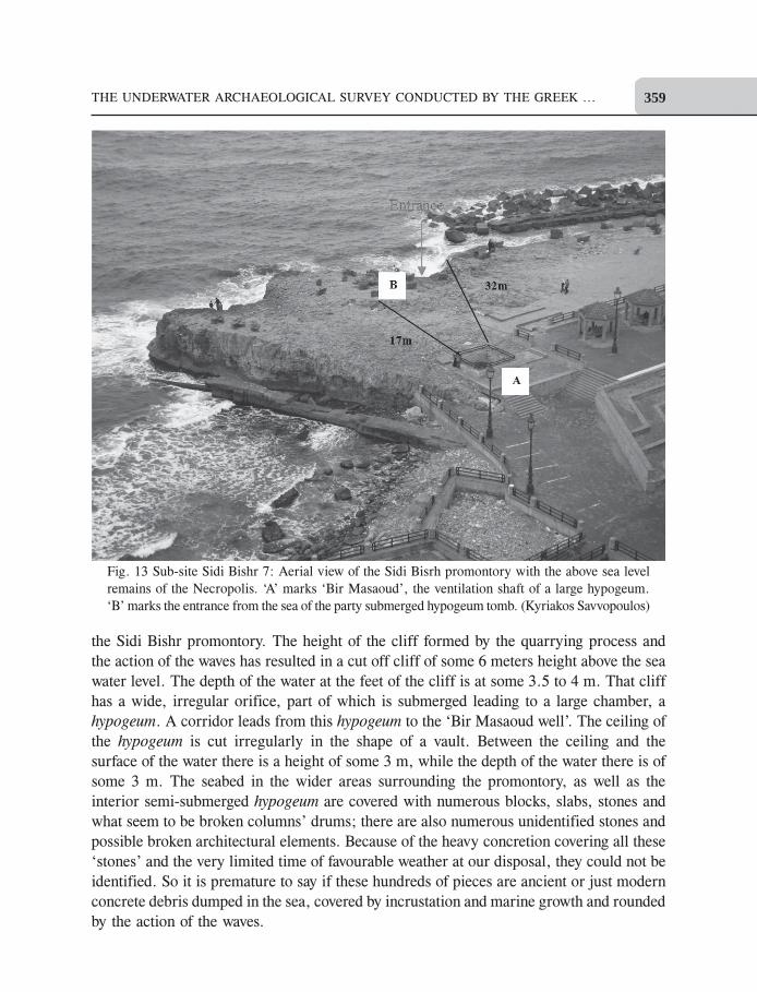
The rocky surface as delimited above bear two large perforations which communicate
with subterranean corridors that are today partly submerged. ‘Bir Masaoud’, also called
the ‘Devil’s well’ is today fenced with a modern low stone wall: it is the ventilation shaft
of an ancient Necropolis (Fig. 13). With a rough sea the sea water reaches the fencing of
Fig. 11 Sub-site Chatby 2: An Early-Christian capital made of grey granite
raised from the area where St. Mark martyrium stood. (Harry Tzalas)
SHIPWRECKS AROUND THE WORLD: REVELATIONS OF THE PAST358
the well and its spray siphons all around the neighbouring surface. At calm sea, the level
of the water in the well is of approximately 3 m from the base of the protective low stone
wall that encircles it. Divers from the Mission did enter the semi submerged chamber and
corridor from the sea and reached the well perforation after swimming for an approximate
distance of some 30 m. There are some other smaller perforations of the rock’s surface;
some are obstructed by stones dumped purposely in them. Some others are minuscule
holes difficult to discern which become obvious only under extreme pressure of the waves
from the North and are apparent because of the siphoning of the sea water.
This entire rocky surface shows marks of erosion and well defined marks of quarrying.
Most of the quarrying activities are visible by the cliff near the sea. In the sea area, as a
buttress to the action of the waves and in order to protect the sandy beach that has been
artificially formed eastwards of the rocky promontory surrounding ‘Bir Masaoud’, a
quay has been built with the use of a large number of concrete blocks. This has created a
sort of artificial lagoon in front of the sea entrance of Bir Masaoud and numerous antiquities
have been destroyed. Looking at the littoral from the sea one notes the abrupt cutting of
Fig. 12 Sub-site Ibrahimieh 3: Medieval stone anchors raised from the reef. (Angelos Yfandis)
THE UNDERWATER ARCHAEOLOGICAL SURVEY CONDUCTED BY THE GREEK ... 359
the Sidi Bishr promontory. The height of the cliff formed by the quarrying process and
the action of the waves has resulted in a cut off cliff of some 6 meters height above the sea
water level. The depth of the water at the feet of the cliff is at some 3.5 to 4 m. That cliff
has a wide, irregular orifice, part of which is submerged leading to a large chamber, a
hypogeum. A corridor leads from this hypogeum to the ‘Bir Masaoud well’. The ceiling of
the hypogeum is cut irregularly in the shape of a vault. Between the ceiling and the
surface of the water there is a height of some 3 m, while the depth of the water there is of
some 3 m. The seabed in the wider areas surrounding the promontory, as well as the
interior semi-submerged hypogeum are covered with numerous blocks, slabs, stones and
what seem to be broken columns’ drums; there are also numerous unidentified stones and
possible broken architectural elements. Because of the heavy concretion covering all these
‘stones’ and the very limited time of favourable weather at our disposal, they could not be
identified. So it is premature to say if these hundreds of pieces are ancient or just modern
concrete debris dumped in the sea, covered by incrustation and marine growth and rounded
by the action of the waves.
Fig. 13 Sub-site Sidi Bishr 7: Aerial view of the Sidi Bisrh promontory with the above sea level
remains of the Necropolis. ‘A’ marks ‘Bir Masaoud’, the ventilation shaft of a large hypogeum.
‘B’ marks the entrance from the sea of the party submerged hypogeum tomb. (Kyriakos Savvopoulos)
SHIPWRECKS AROUND THE WORLD: REVELATIONS OF THE PAST360
The weather conditions were such that the underwater hypogeum and the submerged
corridor could not be even partially surveyed and it is hoped that this will be possible
during our next campaigns. East of the Sidi Bishr promontory and across the beach called
Sidi Bishr No. 2 an islet now called Miami Island has been identified as Gezira Gabr El
Khour which formed part of a small port installation referred to in Pirî Reis Portolan25 as
Kñrñl GñdÈk. An attentive survey of this island has led to the identification of the remains
of numerous ancient burials that were at an unknown period used as stone quarry. A large
hypogeum tomb was excavated. It is obvious that this islet as well as the wider sea area
extending north were part of the large Necropolis of Sidi Bishr. Sidi Bishr, together with
the Early Ptolemaic Necropolis of Chatby26 and the Necropolis of Moustapha Kamel
which covers the whole Hellenistic period, and the submerged remains of Sporting represent
the very last visible remnants of the extended Eastern Necropolis which spread along the
eastern coastline of Alexandria. Contrary to the Necropolis of Sporting which because of
its low level was totally submerged, some scant remains of the Sidi Bishr Necropolis
being at circa 6 m above the present level of the sea were spared.
These remains have never been marked on any archaeological maps of the 19th and 20th
centuries, nor are they specifically referred to in any archaeological survey. The reason
being that at a time when Alexandria and its suburbs where covered with extended ancient
remains, the limited ruins of Sidi Bishr were not considered worth being mentioned, least
surveyed. Travellers and map makers of the 19th and early 20th centuries, in their relations
and annotation refer in brief to ‘a coast covered by ruins’. In our superficial survey at
Sub-site Sporting 5 it was suspected that at an unidentified period before being submerged
the Necropolis, was used as a stone quarry27. At Sidi Bishr as well as on the Gezira El
Khour islet the quarrying is very obvious not only in the submerged parts which now lie
at some 4 to 5 m depth but also on the apparent remains that are high above the water
level. A methodical survey of the preserved remains which are above water level, of the
subterranean corridors, now partly under the water, the wider area which is today totally
submerged as well as the relation of these ruins with two neighbouring islets and reefs
will be undertaken during the future campaigns. In concluding it should be stressed that
the most important of the sub-sites in the area of our concession are Chatby 1 and Chatby
2 where a methodical survey of the sea bottom and the raising of the ancient remains will
shed light on this area that once was part of the royal quarters and where the proto-
Christian site of St. Mark Martyrium stood in its vicinity. Sporting 5 and Sidi Bishr 7 sub-
sites need protection from the constant dumping of concrete blocks and an attentive survey
must be carried out in the near future. Sub-site El Hassan 6 although of capital importance,
due of the presence of ancient shipwrecks, is not presently threatened because of its
important distance from the shores and the depths of over 13 m. Its methodical survey
and excavation can thus wait. The ancient quarry at sub-site Ibrahimieh 4 has been
completely covered by the extension of the coastal road and the reef at Ibrahimieh 3 has
been adequately surveyed; their final publication should be expected soon.
THE UNDERWATER ARCHAEOLOGICAL SURVEY CONDUCTED BY THE GREEK ... 361
Conclusions
With Athens, Rome, Constantinople, Alexandria is one of the great capitals of the ancient
world. It remained an important city and a cultural centre for nearly a millennium and
had a decisive impact on Western civilisation. Sadly, repeated wars, social unrest and
devastating natural phenomena have destroyed the ancient monuments of the Great City.
The scant remains of its glorious past are buried deep beneath 19th and 20th century
cosmopolitan Alexandria, a vision of Mohamed Ali. Only the Column of Diocletian
stands as a faint reminder of the city’s greatness. But due to the rise of the Mediterranean
Sea - at the rate of one meter every thousand years - and the subsidence of the littoral,
important remains of the city’s past are submerged, and thus have been spared. For these
last thirty years, archaeologists-divers have been bringing back to light precious testimonies
of Greco-Roman and Medieval Alexandria.
Acknowledgements
The author would like to express many thanks to Dr. Zahi Hawass, Secretary General of
the Supreme Council of Antiquities of Egypt and to the Director of the Foreign Missions
Affairs Dr. Mohamed Ismail Khaled for the repeated renewal of our concession, as well
as to Dr. Ibrahim Darwish, Mr. Alaa Eldin Mahrous, Dr. Ashraf Abdel Raouf and Dr.
Mohamed Mostapha Abdel Maguid for their continued assistance and to Mr. George
Nomikos, Chief diver and deputy-leader of the Greek Mission for his dedication. Drs.
Jean-Yves Empereur and Mohamed Awad have repeatedly offered their support to our
work.
Endnotes
1I would like to express my many thanks to Dr. Zahi Hawass, Secretary General of the Supreme Council
of Antiquities of Egypt and to the Director of the Foreign Missions Affairs Dr. Mohamed Ismail
Khaled for the repeated renewal of our concession, as well as to Dr. Ibrahim Darwish, Mr. Alaa
Eldin Mahrous and Dr. Ashraf Abdel Raouf for their continued assistance.
2 The Eastern littoral and its suburbs were known in antiquity as Eleusis [pros Eleusini thalassa],
Nicolpolis, Juliopolis.
3 It is known that from the time of the last melting of the glacier, circa 10,000 years BPT the waters of
the Mediterranean rise at a rate of circa one meter per 1,000 years; in Alexandria this phenomenon
coexists with a subsidence of the littoral.
4 Mentioning all the names of my collaborators in the limited space of an article is impractical, but I
would like to refer to those who have repeatedly taken part in our campaigns: The marine archaeologists
Irine Chryssocheri, George Koutsouflakis, Spyros Thermos, the Egyptologist Dr. Kyriakos
Savvopoulos, George Papatheodorou, professor of Marine Geology, the architect-diver Silvana
Gargiulo, the chief divers Phaedon Antonopoulos and George Nomikos.
5 Several associations and individual persons have contributed financially to our campaigns, I will, for
practical reasons, limit myself to acknowledging the main and regular sponsors: The J. F. Costopoulos
SHIPWRECKS AROUND THE WORLD: REVELATIONS OF THE PAST362
Foundation, the Ministry of Culture of Greece, the Psyhas Foundation, the Stavros S. Niarchos
Foundation, Powertek Berhad, Port Said, East S.A.E, Suez Gulf S.A.E, Sidi Krir Generating
Company, Mr. Ananda Krishnan of Kuala Lumpur and Mr. Antonis Nicolaras, Piraeus.
6 The name of the Chatby suburb is due to the tomb, or turba, of a holy man known as Sheih el Chatby.
His funerary chapel was transferred eastwards, in the early part of the 20th century to a nearby
location in the vicinity of St. Mark College.
7 On his plan of 1898 G. Botti places on the Lochias Promontory a ‘Royal Palace’, the ‘Temple of Isis
Lochias’ east of the tip, then south, near Chatby the ‘Tomb of Cleopatra VII’.
8 Carried out by the Department of Marine Geology of the Patras University.
9 This base is comparable to another found in the sea in the 1960’s and exhibited in the garden of the
Maritime Museum at Stanley.
10 The nearest built pylons are those of Taposiris Magna at some 40 km west of Alexandria.
11 Macedonian tombs have marble doors; here we assume that the door was made of granite or of wood.
12 Translation by Ernest Cary, Loeb Classical Library, (1917).
13 Translation by Bernadotte Perrin, Loeb Classical Library, (1920).
14 Paolo Gallo, ‘Fète-sed sous l’eau de la Mèditerrannèe’ Proceedings, First Hellenistic Studies Workshop,
Alexandria 12-18 July 2009, (Ed.), K. Savvopoulos. pp. 64-88, Alexandria, 2010.
15 Naiskos, diminutive of Naos, the Greek word for temple, a lockable shrine for storing religious
images; generally made of wood or stone and placed in temples or tombs.
16 Two campaigns are planned for the year 2011, during spring and autumn.
17 Marurice Martin, ‘Alexandrie Chrètienne à la fin du XIIème siècle d’après Abu l-Makarim’, Alexandrie
mèdievale 1, (Ed.), by Christian Decobert and Jean-Yves Empereur, Etudes alexandrine 3, 1998,
IFAO, Cairo (1998) and Jean Gascou, ‘Les èglises d’Alexandrie: Question de mèthode’ in the same
volume.
18 Veduta d’Alessandria, Anessa con altre al Codice Urbinate 277 della Biblioteca Vaticana ossia codice
Latino di Tolemeo. Il Codice fu scritto per Ugonem Cominelli de Macerii supra Mosam in Francia
Florentiae die quinta Januarii 1472 reproduced for the first time in Gaston Jondet, Atlas Historique
de la Ville et des Ports d’Alexandrie, Societè Sultanieh de Gèographie d’Egypte, Cairo, (1921).
There is another version of this map kept in the National Library in Paris, with minor differences
from the Vatican Codex. This map is also reproduced and commented on in Harry Tzalas, ‘The Two
Ports of Alexandria, Plans and Maps from the 14th century to the time of Mohamed Ali’, Underwater
Archaeology and Coastal Management ‘Focus on Alexandria’ UNESCO, Paris (2000).
Also see Harry Tzalas, ‘The Codex Urbinate 277 and the Plan of Simancas, Two of the Earliest Maps
of Alexandria’ in Tradition and Transition, Proceedings at a Conference held in October 2007 at the
Institute of Nautical Archaeology, A & M University of Texas, in honor of George Bass and K. Van
Doorninck.
19A map made in 1603 by an Italian spy, unknown until the 1980’s, was then found in the General
Archives of Simancas, Vallalolid, Spain, attached to the documents E1102-36 and E1103-34. See
Harry Tzalas, ‘The Two Ports of Alexandria, Plans and Maps from the 14th century to the time of
Mohamed Ali’, Underwater Archaeology and Coastal Management ‘Focus on Alexandria’ UNESCO,
Paris (2000).
20 Maurice Martin, supra cit.
21Evaristo Breccia also notes the Martyrium of St. Mark on his Plan d’Alexandrie à l’èpoque ptolèmaîque
avec quelques sites antiques, made in 1922.
Οι Λίθινες Άγκυρες της Παραλίας Ράµλεχ στην Αλεξάνδρειας της Αιγύπτου –Κάποιες σκέψεις για την χρήση τους», Η Τεχνολογία των Κλασσικών και
Ελληνιστικών Χρόνων, Αρχαιολογία, τεύχος 95/2005, Αθήνα.
22 Harry Tzalas, ‘An unusually large concentration of stone anchors, East of Cape Lochias, Alexandria,Egypt. A Preliminary Evaluation’, Proceedings of the 7th Int. Symposium on Ship Construction inAntiquity, Pylos 1999, Tropis VII, Vol. II, Athens (2002).
23 See plan of T. Neroutsos, in T. Neroustsos, L’Anciènne Alexandrie, Paris, 1888 and of M. Bartocci inE. Breccia, Alexandrea Ad Aegyptum, Bergamo, 1914.
24 See notes 18 and 19.25 Pirî Reis, Kitab I Bahariye, The Historical Research Foundation Centre, Istanbul, 1988.26 Evaristo Breccia, Catalogue Gènèral des Antiquitès Egyptiennes (Musèe d’Alexandrie), La Necropoli
di Sciatbi, Cairo (1912), Vol. 1 and Ernest Sieglin, Expedition, Ausgrabungen in Alexandria, Leipzig(1908).
27 For quarrying activities at the end of the 19th century see: T. Neroutsos, L’Anciènne Alexandrie,Paris, 1888, pp. 2, 74 and 75.
References
Harry Tzalas
2002. ‘The Hellenic Mission’s archaeological Survey in Alexandria: A Preliminary Report’, Papersfrom a session held at the European Association of Archaeologists Seventh Annual Meeting, Esserling2001, BAR International Series 1052, Oxford.
2002. ‘An unusually large concentration of stone anchors. East of Cape Lochias, Alexandria, Egypt. APreliminary Evaluation’, Proceedings of the 7th Int. Symposium on Ship Construction in Antiquity,
Pylos 1999, Tropis VII, Vol. II. Athens.2002. ‘The Hellenic Mission’s Underwater Archaeological Survey in Alexandria, Egypt. A Preliminary
Report 1998-2001’, ΕΝΑΛΙΑ vol. VI, Athens 2002. Evidence of ‘in series’ anchoring?›,Proceedings of the 8th Int. Symposium on Ship Construction in Antiquity, Hydra, Tropis VIII (InPress).
2003. ‘Greco-Egyptian Underwater Archaeological Survey Near Alexandria’ Towards IntegratedManagement of Alexandria’s Coastal Heritage, Unesco Coastal region and small island papers 14,Paris.
2003. ‘The Hellenic Mission’s Underwater Archaeological Survey in Alexandria (Egypt), 2002-2003’,ENALIA VII, Athens.
2005.
2009. ‘Underwater Archaeological Survey of the Greek Mission in the Coastal Area of Ramleh (1998-2008)’, Alexandria Beyond the Myth, Architecture, Archaeology, Urban Changes, Polytechnic Schoolof Milan, pp. 60-65 Mondovi (CN).
2009. ‘The Underwater Archaeological Survey of the Greek Mission in Alexandria, Egypt (1998-2009), Proceedings First Hellenistic Studies Workshop, Alexandria, 12-18 July, 2009, The AlexandriaCentre for Hellenistic Studies, Alexandria.
2012. ‘The Underwater Archaeological Survey of the Greek Mission at the submerged Necropolis ofSidi Bishr, Alexandria, Egypt’, ENALIA, XI , The Journal of the Hellenic Institute of Marine
Archaeology, Athens.
THE UNDERWATER ARCHAEOLOGICAL SURVEY CONDUCTED BY THE GREEK ... 363
SHIPWRECKS AROUND THE WORLD: REVELATIONS OF THE PAST364
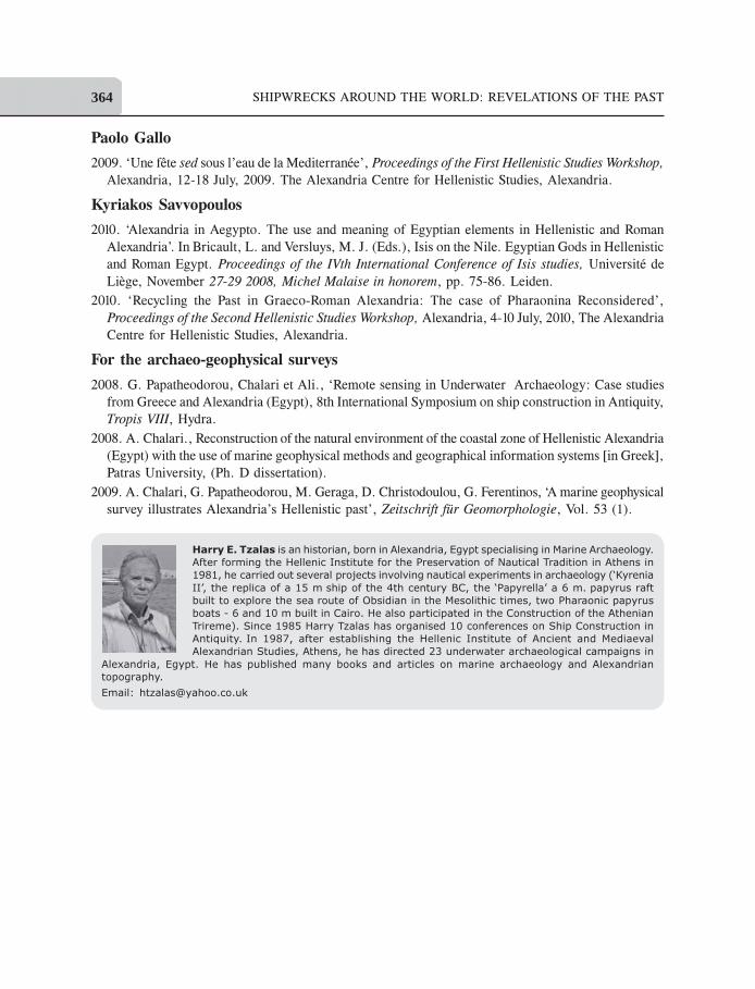
Harry E. Tzalas is an historian, born in Alexandria, Egypt specialising in Marine Archaeology.
After forming the Hellenic Institute for the Preservation of Nautical Tradition in Athens in
1981, he carried out several projects involving nautical experiments in archaeology (‘Kyrenia
II’, the replica of a 15 m ship of the 4th century BC, the ‘Papyrella’ a 6 m. papyrus raft
built to explore the sea route of Obsidian in the Mesolithic times, two Pharaonic papyrus
boats - 6 and 10 m built in Cairo. He also participated in the Construction of the Athenian
Trireme). Since 1985 Harry Tzalas has organised 10 conferences on Ship Construction in
Antiquity. In 1987, after establishing the Hellenic Institute of Ancient and Mediaeval
Alexandrian Studies, Athens, he has directed 23 underwater archaeological campaigns in
Alexandria, Egypt. He has published many books and articles on marine archaeology and Alexandrian
topography.
Email: [email protected]
Paolo Gallo2009. ‘Une féte sed sous l’eau de la Mediterranèe’, Proceedings of the First Hellenistic Studies Workshop,
Alexandria, 12-18 July, 2009. The Alexandria Centre for Hellenistic Studies, Alexandria.
Kyriakos Savvopoulos2010. ‘Alexandria in Aegypto. The use and meaning of Egyptian elements in Hellenistic and Roman
Alexandria’. In Bricault, L. and Versluys, M. J. (Eds.), Isis on the Nile. Egyptian Gods in Hellenistic
and Roman Egypt. Proceedings of the IVth International Conference of Isis studies, Universitè de
Liçge, November 27-29 2008, Michel Malaise in honorem, pp. 75-86. Leiden.
2010. ‘Recycling the Past in Graeco-Roman Alexandria: The case of Pharaonina Reconsidered’,
Proceedings of the Second Hellenistic Studies Workshop, Alexandria, 4-10 July, 2010, The Alexandria
Centre for Hellenistic Studies, Alexandria.
For the archaeo-geophysical surveys2008. G. Papatheodorou, Chalari et Ali., ‘Remote sensing in Underwater Archaeology: Case studies
from Greece and Alexandria (Egypt), 8th International Symposium on ship construction in Antiquity,
Tropis VIII, Hydra.
2008. A. Chalari., Reconstruction of the natural environment of the coastal zone of Hellenistic Alexandria
(Egypt) with the use of marine geophysical methods and geographical information systems [in Greek],
Patras University, (Ph. D dissertation).
2009. A. Chalari, G. Papatheodorou, M. Geraga, D. Christodoulou, G. Ferentinos, ‘A marine geophysical
survey illustrates Alexandria’s Hellenistic past’, Zeitschrift fñr Geomorphologie, Vol. 53 (1).