Embed Size (px)
Citation preview

§2NW.ii93 02 16 .0062
usas-OFR-87-617 USGs-OFR- 87-617
* UNITED STATES DEPARTMENT OF THE INTERIOR
GEOLOGICAL SURVEY
LATE CENOZOIC EVOLUTION OF THE
UPPER AMARGOSA RIVER DRAINAGE SYSTEM,
SOUTHWESTERN GREAT BASIN,
NEVADA AND CALIFORNIA
By
' I t..•
- .o-. r
N. King Huberz
Open-File Report 87-617
Prepared in cooperation with the U.S. Department of Energy Nevada Operations Office
(Interagency Agreement DE-AI08-78Er4402)
This report is preliminary and has not been reviewed for conformity with
U.S. Geological Survey editorial standards.
Menlo Park, California 1988
INFORMATION ONLY9~3031Oo 93 -O PDR 110909330 W -1* 1 WAST PDR
1.

USGS-OFR-87-617
UNITED STATES DEPARTMENT OF THE INTERIOR
GEOLOGICAL SURVEY
LATE CENOZOIC EVOLUTION OF THE
UPPER AMARGOSA RIVER DRAINAGE SYSTEM,
SOUTHWESTERN GREAT BASIN,
NEVADA AND CALIFORNIA
By
N. King Huber
INFORMATION ONLY
USGS-OFR-87-617

Contents Page
Abstract ........ .... ................ ............. * * * * ** !! *.......... . 1 Introduction .............................. * * * * * * * *
Timber Mountain area .. .. . ..... . .. .. . .. 0 . .. .. . ... .. . .. . .. .*. . .. . ....... 3
Forty. ..e Canyon drainage basin ............................. . 3 Eastern Thirsty Canyon drainage basin 10
Beatty Wash drainage basin .................................... .0..*. 10
Summary of drainage evolution in the Timber Mountain area ........ 11 Black Mountain area ....................... *.........*.....0.............. 11
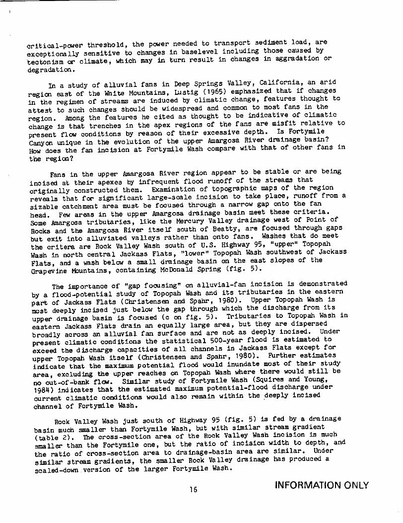
Fortymile Wash and alluvial-fan incision .............. ...... 11
Comparison of Fortymile Wash with other cases of fan incision.... 15
Amargosa River south of Beatty .......................... ...... ..... 21 References cited ...................................... . . ....... 0.... 24
Illustrations
Figure 1. 2. 3. 4. 5. 6.
7. 8.
Index map, upper Amargosa River drainage basin .............
Timber Mountain area .................... .. ... .. .........
Geologic map of Fortymile Canyon area ......................
Geologic map of Thirsty Canyon and Beatty Wash area ........
Location of drainage basins and incised alluvial fans ......
Relation between cross-section area of incised channel
and drainage-basin area ..........................
Relation between channel gradient and drainage-basin area..
Relation between channel gradient and the ratio of channel
cross-section area to drainage-basin area.............
Tables
Table 1. Generalized volcanic stratigraphic units in the Timber Mountain area ............ .. *.........0....0.0e.......... 5
2. Examples of alluvial fan incision .......................... 18
INFORMATION ONLY
i
2 4 6
12 17
20 20
20
LATE CENOZOIC EVOLUTION OF THE UPPER AMARGOSA RIVER DRAINAGE SYSTEM,
SOUTHWESTERN GREAT BASIN, NEVADA AND CALIFORNIA
By N. King Huber
ABSTRACT
A major part of the upper Amargosa River drainage system is centered on
Timber Mountain, a high central area within a volcanic caldera northeast of
Beatty, Nevada, on the west margin of the Nevada Test Site. The basic drainage pattern in this area was established soon after caldera collapse and
resurgent dome formation about 11 million years ago. The gross drainage
pattern has changed little since then, although subsequent volcanic activity
has temporarily blocked drainage channels. As there have been no significant
changes in subbasin geometry, general tectonic stability of the region during
this time is implied.
A major change in alluvial regimen occurred with the end of major
alluvial-fan construction within the drainage system and the beginning of fan
head erosion that formed incised washes. The size and shape of incised
channels differ, but they show a similar relation to the geomorphic parameters of their respective drainage basins-including such diverse-appearing washes
as the deep Fortymile Wash and the wide, shallow wash on the Amargosa River
downstream from Beatty. If the subbasin drainages have not changed appreciably during the Quaternary, then the forcing mechanism for the change in
alluvial regimen is most likely either climatic or tectonic. Because this
change appears to have occurred at about the same time throughout the upper
Amargosa River drainage system, a climatic cause is preferred; its nature and
timing are still speculative, but probably was increasing aridity that reached a threshold in the middle Pleistocene.
This analysis also concludes that a postulated Pleistocene drainage
capture by the Fortymile Canyon drainage system did not occur and that a large
Pliocene lake in the Amargosa Desert, the postulated "Lake Amargosa," is
equivocal.
INTRODUCTION
The Amargosa River drains part of the southwestern part of the Great
Basin section of the Basin and Range physiographic province. The Amargosa River originates near Pahute Mesa in southern Nye County, Nevada, and flows
southward for about 90 km before making a U-turn westward and northward into
Death Valley, California. The study area is the upper Amargosa and its many
tributaries that drain generally southward into the Amargosa Desert (fig.
1). A recent summary of the general physiographic, geologic, and tectonic setting of the Basin and Range province provides a broad context for the present study (Dohrenwend, 1987).
This study analyzes the late Cenozoic evolution of the upper Amargosa drainage system as one element of a larger effort done in cooperation with the
U.S. Department of Energy, Nevada Nuclear Waste Storage Investigations Project
(Interagency Agreement DE-AI08-78ET44802), to elucidate effects of regional
late Cenozoic tectonic history on a potential radioactive waste repository at
Yucca Mountain (fig. 1). Field examination was precluded, and so this report
INFORMATION ONLY1

1 1601 11600-01'k
UPPER AMARGOSA RIVERS DRAINAGE BASIN ,j-
In 40 Miles
10 0 10 20 30 40 s0 Kilometms iTe T .- 4-I.dex p u a i d
Figure 1 .-- In'dex map, upper Amargosa River drainage basin.
2 INFORMATION ONLY
370
00'
360 30'
20 3 0I
116o000'116030'

is based on published reports and geologic maps, topographic maps, and aerial
photographs.
In this review the upper drainage system is not discussed in uniform
detail. Emphasis is on areas and topics like the late Cenozoic volcanic
stratigraphy of the region that reveal evolution of this drainage system,
which may in turn aid in understanding the region's late Cenozoic tectonics.
The bedrock geology of most of the area of the upper Amargosa River
drainage system has been mapped in considerable detail at 1:24,000 scale. But
the most useful geologic maps to use with this report are compilations at a
scale of 1:48,000: the Timber Mountain caldera area (Byers and others, 1976)
and the Jackass Flats area (Maldonado, 1985). These compilations index the
more detailed 1:24,000-scale geologic source maps. Maps in this report (figs.
3 and 4) are generalized from these published maps.
TIMBER MOUNTAIN AREA
A major part of the upper Amargosa River drainage system lies south of
Pahute Mesa and is centered on Timber Mountain, a high central area within a
volcanic caldera 25 to 30 km in diameter (fig. 2). The caldera formed by
collapse as a result of the eruption of the Rainier Mesa and Ammonia Tanks
Members of the Timber Mountain Tuff about 11.5 million years (m.y.) ago (table
1). Later extrusion of the Timber Mountain resurgent dome and eruption of
minor intracaldera tuff and lava formed the Timber Mountain physiographic high
in the center of the caldera.
From the high ground of the resurgent dome, drainage radiated into the
surrounding caldera moat. Drainage was blocked to the north by extra-caldera
Timber Mountain Tuff and older units on Pahute Mesa, and to the south by the
high rim and resurgent core of a segment of the earlier Claim Canyon cal
dera. Drainage westward from the Timber Mountain area developed as Thirsty
Canyon and Beatty Wash to the Amargosa River and thence south on the regional
gradient. The southeast rim of the Timber Mountain caldera was breached via
Fortymile Canyon where drainage from the eastern moat flows south to join the
Amargosa River in the Amargosa Desert.
Fortymile Canyon Drainage Basin
Southeast of the Timber Mountain resurgent dome, Fortymile Canyon was
eroded to at least its present depth before eruption of the rhyolite lavas of
Fortymile Canyon, for remnants of these lavas lie on the present canyon floor
(fig. 3) and their basal contact rises away from the canyon, which shows that
a topographic low existed there at the time of the eruption. A test well
drilled in Fortymile Canyon at the junction of Pah Canyon, just south of the
caldera margin, penetrated about 12 m of alluvial fill, 45 m of the rhyolite
of Fortymile Canyon, and bottomed in the rhyolite of Calico Hills (Waddell,
1985, table 1). The rhyolite of Calico Hills and the Paintbrush Tuff, both
older than the Timber Mountain caldera, crop out discontinuously from Pah
Canyon south along Fortymile Canyon and constitute the bedrock into which the
canyon was incised before the eruption of the rhyolite of Fortymile Canyon.
The age of the rhyolite of Fortymile Canyon is indefinite but it must be
between that of the Timber Mountain Tuff (11.5 m.y.) and the rhyolite of
Shoshone Mountain, (about 9 m.y. old) (table 1).
INFORMATION ONLY3

116"45' 116030' 116015'
BOUNDARY OF AMARGOSA RIVER DRAINAGE
3 7 0: aS1,'
-•1, 'k Lý ¢
O -.
37* ,.,,, M-UNA
00, BOUNDARY OF TIMBER
'ýMOUNTAIN, CALDERA p..
4A 4 o'&' Q9 -'
)VI
S0 • I0 15 U b•ljtý(' M111%
Figure 2.-The Timber Mountain area. Dotted line indicates approximate outer
boundary of subsidence of the Timber Mountain caldera (Byers and others, 1976).
INFORMATION ONLY
Table 1 .-- Generalized volcanic stratigraphic units in the Timber Mountain area mentioned in text
Stratigraphic Unit Volcanic center or caldera
Approximate age (m.y.)
Trachybasalt of Buckboard Mesa
Basalt above Thirsty Canyon Tuff (Thirsty Canyon area)
Thirsty Canyon Tuff
Rhyolite of Shoshone Mountain
Mafic lavas of Dome Mountain
Rhyolite of Fortymile Canyon
Timber Mountain Tuff
Pre-Timber Mountain Tuff rocks (Includes Paintbrush Tuff and ryholites of Calico Hills)
Scrugham Peak (east moat of Timber Mountain caldera)
Knob west of Thirsty Canyon? with triangulation station "Thirsty"
Black Mountain
Shoshone Mountain
Dome Mtn. (south moat of Timber Mountain caldera)
Pinnacles Ridge (west of Fortymile Canyon)
Timber Mountain
Various sources
2.8ay
8Y!
11
>11.-2
1 /Age from f. J. Fleck (written commun., 1980)
--/Age from Carr (1984, fig. 33)
5
INFORMATION ONLY

116015
• I - •' * " I''
I ", V. .t•
I.-: (
2 .. LOMII ...7 SI 0 70
M2 MILES.!
Figure 3.--Generaiized geologic map of Fortymile Canyon area showing distribution
of major post-Timber Mountain Tuff volcanic units.
6 INFORMATION ONLY
116*22'30"
O lllll
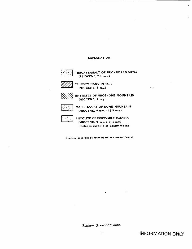
EXPLANATION
S1TRACHYBASALT OF BUCKBOARD MESA
(PLIOCENE, 2.8, my.)
STHIRSTY CANYON TUFF
(MIOCENE, 8 m.y.)
SRHYOLITE OF SHOSHONE MOUNTAIN
(MIOCENE, 9 m.y.)
W MAFIC LAVAS OF DOME MOUNTAIN (MIOCENE, 9 m.y. >11.5 m.y.)
RHYOLITE OF FORTYMILE CANYON (MIOCENE. 9 m.y.> 11.5 m.yJ
(Includes rhyolite of Beatty Wash)
Geology generalized from Byers and others (1976).
Figure 3.--Continued
INFORMATION ONLY
ElI'
7

Thus the Timber Mountain caldera rim was breached and Fortymile Canyon
drainage established in its present location soon after the resurgent dome
formed within the caldera. The rhyolite of Fortymile Canyon consists of many
flows erupted from vents near the south rim of the Timber Mountain caldera.
Some of these filled Fortymile Canyon to a depth of more than 425 m near
Delirium Canyon, and flowed northeast up Fortymile Canyon into the eastern
moat of the Timber Mountain caldera. Eruption of the rhyolite into the
ancestral Fortymile Canyon apparently was insufficient to divert the drainage,
for the stream incised into the lavas and exhumed the earlier canyon nearly to
its former level.
After the lower Fortymile Canyon was reexcavated nearly to its earlier
depth, the mafic lavas of Dome Mountain were erupted into the canyon and part
of the moat east of Timber Mountain (fig. 3). Mafic lava of Dome Mountain
overlies rhyolite of Fortymile Canyon within Fortymile Canyon about 1.5 km
north of the junction of Pah Canyon only about 30 m above the present
streambed (Christiansen and Lipman, 1965). This outcrop indicates that
Fortymile Canyon here had incised to near its present depth before eruption of
the mafic lavas of Dome Mountain. Although these lavas filled Fortymile
Canyon southeast of Dome Mountain by at least 180 m, their volume was
insufficient to divert the stream, which then incised through the new
obstacle.
The rhyolite of Shoshone Mountain was erupted about 9 m.y. ago (Table 1)
near the southeast rim of the Timber Mountain caldera, and several flows
advanced toward the main chasm of Fortymile Canyon (fig. 3). Because present
outcrops form cliffs within the canyon, in places only 30 to 90 m above its
bottom, probably the canyon was at least partly blocked though probably not to
any great depth and not enough to divert the stream.
About 8 m.y. ago (table 1) the Thirsty Canyon Tuff erupted from the Black
Mountain caldera, some 30 km northwest of Timber Mountain. This tuff probably
blanketed much of the Timber Mountain caldera; it still fills most of the
north and west moat and erosional remnants remain in the moat east of Timber
Mountain and in the south moat in Beatty Wash (fig. 3). Most of the Thirsty
Canyon Tuff that once blanketed the Fortymile Canyon drainage basin has been
eroded and flushed out through the canyon.
Between eruptions of these major volcanic units, gravelly and tuffaceous
sediment accumulated in the eastern moat. These materials are preserved as
extensive alluvial and coliuvial deposits that extend from the north and east
caldera rim into Fortymile Canyon and its tributaries. As much as 80 m of
this material underlies the Thirsty Canyon Tuff in Fortymile Canyon near the
south end of Buckboard Mesa (Byers and others, 1966). Similar material
stratigraphically above the Thirsty Canyon Tuff constitutes much of the
present-day surface in the east moat. While the lower Fortymile Canyon was
not temporarily blocked by volcanic flows or tuff, such gravel and sediment
probably supplied most of the stream bedload that moved through the canyon and
accumulated as an extensive alluvial fan extending into the Amargosa Desert.
About 2.8 m.y. ago the trachybasalt of Buckboard Mesa (fig. 3) erupted
from a cinder cone (Scrugham Peak) northeast of Timber Mountain (table 1), and
flowed southeast at least 7 km down the Fortymile drainage. Erosion has
isolated the basalt as a mesa; the main trunk of Fortymile Canyon runs along
8F ýJ 1-11 V WIA I i U I'%

the west margin of the mesa and has cut as much as 100 m (average rate of 3.6
cm/1000 yr) into older tuff (including Thirsty Canyon Tuff) and fan gravel
beneath the basalt.
The presence of a layer of Thirsty Canyon Tuff within the gravel beneath
the trachybasalt of Buckboard Mesa (Byers and others, 1966) indicates that
Fortymile Canyon was deeper when the tuff was erupted than when the
trachybasalt was erupted, and also indicates that the channel aggraded both
before and after deposition of the tuff. Sometime after the eruption of the
trachybasalt, Fortymile Canyon and its tributaries incised through the tuff
and into the underlying gravel to leave the trachybasalt flows as an isolated
mesa.
In summary, from about 11 to 8 m.y. ago, after the Timber Mountain
caldera formed with its resurgent dome until eruption of the Thirsty Canyon
Tuff from the Black Mountain caldera, the Fortymile Canyon stream from the
Timber Mountain caldera was forced several times to cut through dams of tuff
and lava flows. Yet the stratigraphic level of the main canyon leaving the
caldera is nearly the same as when the canyon formed some 10 m.y. ago. During
this time (especially since 8 m.y. ago) there has been little major change in
the base level at the canyon mouth, where a braided stream in a bedrock canyon
merged with an alluvial fan. There also has been little change in the size
and shape of the Fortymile Canyon drainage basin.
During the millions of years that Fortymile Canyon has drained the east
moat of Timber Mountain caldera, voluminous volcanic-rock and other eroded
material has accumulated as a great alluvial fan extending from the canyon
mouth southward into the Amargosa Desert. But now, fan construction has
ceased, for the fan apex has been deeply incised by infrequent storm runoff
from Fortymile Canyon to form Fortymile Wash. Fan incision of this magnitude
is thought to start by reduced sediment load relative to water discharge
(Hooke, 1967; Wasson, 1977; Wells and Harvey, 1987). Such changes are
inferred to result from disturbance in the source area. Climatic change and
tectonic movement are two commonly assumed causes of such disturbance if the
general geomorphic characteristics (size, shape, average slope and relief,
etc.) of the drainage basin have not otherwise been changed (Hooke, 1967;
Bull, 1979).
It has been suggested that fan incision was initiated by increased
discharge from Fortymile Canyon because of stream capture of the upper part of
a drainage basin formerly draining through Beatty Wash until about 300,000
years ago (D.L. Hoover, cited by Carr, 1984, p. 77). This inference is based
on a tentative age of about 300,000 years for the upper part of the fan
deposit adjacent to the incised wash, as determined by the experimental
uranium-trend dating method (U.S. Geological Survey, 1984, table 1). But the
trachybasalt of Buckboard Mesa flowed into the upper part of the Fortymile
drainage about 2.8 m.y. ago and the base of the basalt flow at its present
southern extent in Fortymile Canyon is 150 m lower than the lowest point on
the present divide between the Fortymile Canyon drainage basin and Beatty
Wash. Thus as long ago as 2.8 m.y. the upper Fortymile Canyon basin could not
have drained into Beatty Wash. The area of the present Fortymile Canyon
drainage basin has probably changed little since its inception.
INFORMATION ONLY

Eastern Thirsty Canyon Drainage Basin
The history of drainage on the west side of Timber Mountain is similar to
that of Fortymile Canyon on the east side. The northwest moat of the Timber
Mountain caldera drains southwest to the Amargosa River via two forks of
Thirsty Canyon, the East Fork, and Rocket Wash (fig. 2). Rhyolite lava flows
within the channels of both the East Fork and Rocket Wash where they breach
the caldera rim have been correlated with the rhyolite lavas of Fortymile
Canyon (Byers and others, 1976). Trachyandesite lava flows overlying the
rhyolite flows are correlated with the mafic lavas of Dome Mountain (Byers and
others, 1976). Although the rhyolite and trachyandesite in the Thirsty Canyon
area (fig. 4) do not have the same eruptive source vents as the Fortymile and
Dome Mountain units, they must be part of the same eruptive cycle as they are
similarly sandwiched between the Timber Mountain Tuff and the Thirsty Canyon
Tuff. Thus the northwest caldera rim was breached and external drainage
established to nearly its present depth soon after the Timber Mountain
resurgent dome formed. Later eruptions have produced a series of volcanic
infillings and reexcavations within these western canyons. After a new
channel was cut into the trachyandesite, the Thirsty Canyon Tuff and an
overlying basalt were erupted into the drainage and then incised (fig. 4).
The basalt, about 8 m.y. old (table 1), seems to represent the last eruptive
event in the Thirsty Canyon drainage. Erosion since then seems to have been
uninterrupted; locally Rocket Wash has cut about 60 m below the base of the
basalt (average rate of 0.75 cm/1 0 0 0 yr). Above its junction with Rocket
Wash, Thirsty Canyon with its much larger drainage basin has cut down about
180 m below the basalt (average rate of 2.25 cm/10 0 0 yr). Minor post-basalt
faulting with northerly strike has occurred. But otherwise the basalt and the
Thirsty Canyon Tuff are little disturbed; they exhibit very low, perhaps
original, dips. Thus there has been little tectonic disturbance in the
Thirsty Canyon area since eruption of the Thirsty Canyon Tuff some 8 m.y. ago.
Beatty Wash Drainage Basin
The southwest moat of the Timber Mountain caldera drains westward to the
Amargosa River via Beatty Wash and its tributaries (fig. 2). An 8-km stretch
of Beatty Wash is underlain by the rhyolite of Beatty Wash (fig. 4). This
rnyolite is about the same age as the rhyolite of Fortymile Canyon. Both
postdate collapse of the Timber Mountain caldera, and both are overlain by the
mafic lavas of Dome Mountain. The presence of the rhyolite of Beatty Wash
indicates that the wash was close to its present depth and gradient 9-11 m.y.
ago. Since then erosion has removed post-rhyolite volcanic flows and tuffs
and some of the rhyolite to exhume its earlier channel. Beatty Wash breaches
the west rim of Timber Mountain caldera through a ridge if Timber Mountain
Tuff. This barrier, and the small drainage area (175 km ) behind it explains
why Beatty Wash is not more deeply incised within the caldera moat. A 10-km
stretch of Beatty Wash upstream from the caldera rim has a mean gradient of
about 15 m/km. Beatty Wash continues west past the caldera rim through more
Timber Mountain Tuff and other volcanic and volcaniclastic rocks to join the
Amargosa River in Oasis Valley about 5 km north of Beatty. This western
stretch has a gradient of about 18 m/km, 20 percent greater than that upstream
within the caldera moat, which further shows the influence of the caldera-rim
barrier on the long profile of Beatty Wash. Except for a few minor north- to
north-northwest-trending faults cutting the rhyolites of Beatty Wash and the
mafic lavas of Dome Mountain (Byers and others, 1976), there is little
INFORMATION ONLY
10

evidence for major tectonic disturbance within the southwest moat of the
Timber Mountain caldera.
Summary of Drainage Evolution in the Timber Mountain Area
The resurgent dome of Timber Mountain and its surrounding caldera moat
are drained by three separate tributaries of the Amargosa River: Fortymile
Canyon, Thirsty Canyon, and Beatty Wash. These three systems have similar
histories and evolved independently just after the caldera collapsed and the
resurgent dome formed. Each breached the caldera rim to drain a portion of
the caldera moat. The distribution of post-Timber Mountain volcanic rocks
shows that Fortymile and Thirsty Canyons had breached the rim at least by 9
m.y. ago; Beatty Wash might not have breached the rim quite as early, for
similar volcanic rocks in Beatty Wash are not known to have crossed through
the rim-gap there. After external drainages were established, they each were
repeatedly disrupted by emplacement of younger volcanic rocks and then reex
cavated their channels. The last significant disruption occurred with the
eruption of the Thirsty Canyon Tuff about 8 m.y. ago. Each reexcavation seems
to have reached about the same depth as today's channels. The general base
level of the Timber Mountain area has been little changed for many millions of
years, except by temporary channel blockages by volcanic materials.
BLACK MOUNTAIN AREA
Black Mountain is located in the northwestern corner of the upper
Amargosa drainage basin about 30 km northwest of Timber Mountain (fig. 2).
Black Mountain is the site of the Black Mountain caldera, the source of the
Thirsty Canyon Tuff (Noble and Christiansen, 1974; Noble and others, 1984), a
volcanic marker bed helpful to unraveling the history of the Timber Mountain drainage system.
The south and east slopes of Black Mountain are drained by Thirsty Canyon
and its West Fork, incised into the south-sloping surface of the Thirsty
Canyon Tuff. Although partly diverted around a plateau underlain by 8-m.y.
old basalt (table 1), the drainage appears to be consequent upon the original
slope of the Thirsty Canyon Tuff (fig. 4). The geology of this area has been
only partly mapped in detail, but that mapping provides no evidence of
tectonic control of the Thirsty Canyon and West Fork drainage systems. Faults
later than the Thirsty Canyon Tuff are minor and strike northerly.
FORTYMILE WASH AND ALLUVIAL-FAN INCISION
Fortymile Canyon opens onto a low-gradient alluvial-fan deposit near the
west edge of Jackass Flats. Near the fan apex the stream channel is incised
15 to 20 m into the fan surface. This channel, known as Fortymile Wash,
shallows southward until it merges with the fan surface about 23 km from the
canyon mouth. Fortymile Wash is the largest channel cut into alluvial-fan
deposits in the upper Amargosa River drainage system. Is its origin anomalous
with respect to the evolution of the rest of the upper Amargosa River drainage
system?
Wells and Harvey (1987) describe fan deposition and incision resulting
from an unusually intense, short-duration storm in northwest England.
Although not in an arid environment, this event is a well-documented example
INFORMATION ONLY
11
I
A L�.L
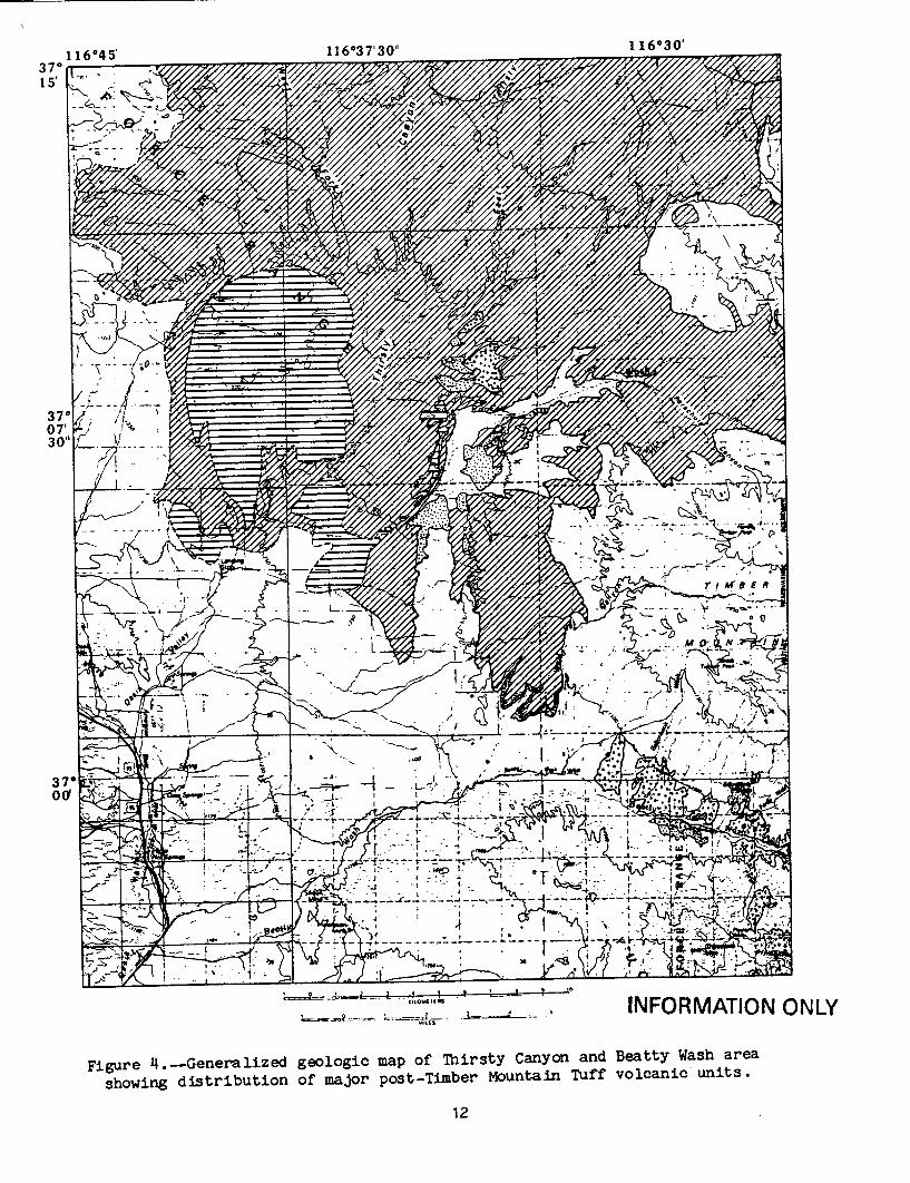
, I I INFORMATION ONLY
Figure 4.--Generalized geologic map of Thirsty Canyon and Beatty Wash area
showing distribution of major post-Timber Mountain Tuff volcanic units.
12
370 15,
370 07' 30'
116*30'
307 0oo'
1 1 A0"1271 q A"'
I
I
S .. -,. 4 .
' -, -_i; ;:
1- *4
~~~~i 6 E Of .. • .
,.__,._...- "- , ,,•o• , • . ,"L
• • - -_-__-_--_- --I"" ' "V
_ .. : ... ;,''.OF.•

EXPLANATION
BASALT ABOVE THIRSTY CANYON TUFF
(MIOCENE. 8 m.y.)
STHIRSTY CANYON TUFF
(MIOCENE. 8 m.y.)
SMAFIC LAVAS OF DOME MOUNTAIN
(MIOCENE, 9 m.y. > 11.5 m.y.)
I....' RHYOLITE OF FORTYMILE CANYON (MIOCENE, 9 m.y. >11.5 m.y.)
(Includes rhyolite of Beatty Wash)
Geology generalized from Byers and others (1976); dashed boundaries
in western part from reconniassance mapping by Cornwall (1972).
INFORMATION ONLY
Figure 4.--Continued
13
of a catastrophic storm mobilizing sediment at source and transporting it into
the fluvial system and onto fan surfaces. Fan deposition involved an early
phase of debris flow followed by a systematic change to more dilute
conditions, resulting in streamflow deposition and eventually in channel
incision. A prolonged succession of such events would continue to enlarge the
fan while leaving a moderately incised channel at the end of each event.
In arid regions it is even clearer that alluvial fans are constructed by
debris flows mobilized during infrequent, episodic periods of intense precipi
tation. Beaty (1963, 1974) described some historic debris flows in the White
Mountains of the western Great Basin and concluded that the alluvial fans
there consist of superposed debris-flow deposits modifed only slightly by
"normal" erosional and depositional processes. He also noted channel incision
following passage of the debris flow and transition to less dense, higher
water-content material.
In a significant study of processes on arid-region alluvial fans, Hooke
(1967) concluded that: "Material is transported to fans by debris flows or water flows that
follow a main channel. This channel is generally incised at the fanhead,
because there water is able to transport on a lower slope the material
deposited earlier by debris flows. The main channel emerges onto the
surface near a midfan point, herein called the 'intersection point.' On
laboratory fans most deposition above the intersection point is by debris
flows that exceed the depth of the incised channel. Fluvial deposition
dominates below the intersection point. This depositional relation
probably also occurs on natural fans" (p. 438). Thus fanhead "incision
can be the natural result of an alternation of debris flows and water
flows and fanheads are, so to speak, 'born incised'" (p. 457). "The depth
of incision produced in these ways and uninfluenced by any other factors,
may be called the depth of normal fanhead incision. In many instances
fanhead incision is so great that overbank deposition on the adjoining fan
surface is impossible. It is inferred that in these instances the fan
source system has been altered in some way * * *. Climatic change and
tectonic movement are two common causes of such alteration " (p. 458).
If the depth of fanhead incision is so great that overbank deposition does not
occur for a geologically long period of time, possible external causes for
such incision should be considered.
Is the depth of fanhead incision at Fortymile Wash normal, in the sense
defined by Hooke, or is it excessive and therefore indicative of a major change in stream regimen? Examination of 1:60,000-scale aerial photographs
(AMS Proj. 109, Area G, 1952) reveals no evidence for overbank flow, whether by debris flow or water, upstream from the channel intersection point about 3
km north of U.S. Highway 95. At this point the channel spreads out into
distributaries, where minor fan-surface deposition has taken place during
recent times; lack of desert varnish gives these recent deposits a lighter tone on the photographs. On the photographs, the fan surface on both sides of
Fortymile Wash appears remarkably smooth, unlike the hummocky one normally produced by debris flows. The surficial geology near Fortymile Wash has been
mapped by Swadley (1983) who describes the fan surfaces as flat and smooth and
consisting of stream-reworked windblown sheet sand deposits with almost no
drainages developed within the sheets. It would appear that there has been no
overbank deposition from Fortymile Wash during A geologically significant
INFORMATION ONLY14
period of time. Age data obtained by the experimental uranium-trend dating
method suggests that gravels in the upper part of the alluvial fan are no more
than one-half million years old (Rosholt and others, 1985, Table 5) and thus
fan construction in this area ceased sometime after one-half million years
ago.
Flood-potential estimates for Fortymile Wash indicate that under present
climatic conditions the 100-year, 500-year, and "regional maximum" floods
would remain within the deeply incised channel, with considerable freeboard
left over (Squires and Young, 1984). Moreover, the entire Fortymile drainage
system is adjusted to the baselevel of this incised channel. Upstream within
the lower Fortymile Canyon, the streambed is graded to the fanhead channel and
is cut into terraces that are graded to the fan surface. Small streams
tributary to the canyon have incised their own small fans to reach grade with
the main channel. In the upper Fortymile drainage system, stream channels are
also in equilibrium with the lower canyon, having cut into older alluvial
deposits in the upper basin. Thus whatever caused the change from active fan
construction to incision of the deep Fortymile Wash has had sufficient time to
affect the entire drainage basin.
Tectonism may be the cause for excessive incision of some alluvial
fans. Hooke (1967; 1972), for example, infers that fans on the west side of
southern Death Valley have been deeply incised because of eastward tilting of
the valley. If the Timber Mountain area were being uplifted in such a way as
t.o tilt the Fortymile Canyon drainage to the south, a situation similar to,
but perhaps more subtle than, the Death Valley situation might occur.
Carr (1984, p. 82) inferred Quaternary southward tilting of the Amargosa
Desert basin citing the south-southeastward decrease in altitude of the top of
"apparently continuous lake and playa deposits." The limit of such deposits
has been taken as an "approximate limit of Lake Amargosa" and shown on a map
of the Big Dune 15-minute quadrangle just west of lower Fortymile Wash
(Swadley and Carr, 1987). Although acknowledging that the lake at times may
have consisted only of spring-fed marshes and ponds, they further suggested
that the "lake" extended to the south-southeast approximately 35 km beyond the
quadrangle. Such a lake would have been more than 65 km long and filled most
of the Amargosa Desert basin. But detailed study of carbonate rocks and marl
in the basin led Hay and others (1986, p. 1501-1502) to conclude that the
Amargosa Desert contained spring-fed playas, marshland, and short-lived ponds
2.1 to 3.2 m.y. ago and that there is no evidence, such as shoreline sediment
or deep-water clay, for a large lake (p. 1495). As their convincing arguments
cast doubt on the postulated "Lake Amargosa" shoreline, that hypothetical
feature is not a valid basis for calculating an amount and rate for Quaternary
tilt of the Amargosa Desert region as done by Carr (1984, p. 79. tables 2, 3).
Comparison of Fortymile Wash with Other Cases of Fan Incision
The change from alluvial-fan construction to fan incision is inferred to
have been caused by some change in the fan-source system. The size of the
Fortymile Canyon drainage basin apparently has not changed significantly since
its inception shortly after the formation of the Timber Mountain caldera some
11 m.y. ago. Voluminous debris has been eroded and removed from the basin,
but as no new rock types have been exposed the material supplied to the stream
has remained constant. Bull (1979) ephasizes that reaches of streams at the
INFORMATION ONLY15
critical-power threshold, the power needed to transport sediment load, are
exceptionally sensitive to changes in baselevel including those caused by
tectonism or climate, which may in turn result in changes in aggradation or
degradation.
In a study of alluvial fans in Deep Springs Valley, California, an arid
region east of the White Mountains, Lustig (1965) emphasized that if changes
in the regimen of streams are induced by climatic change, features thought to
attest to such changes should be widespread and common to most fans in the
region. Among the features he cited as thought to be indicative of climatic
change is that trenches in the apex regions of the fans are misfit relative to
present flow conditions by reason of their excessive depth. Is Fortymile
Canyon unique in the evolution of the upper Amargosa River drainage basin?
How does the fan incision at Fortymile Wash compare with that of other fans in
the region?
Fans in the upper Amargosa River region appear to be stable or are being
incised at their apexes by infrequent flood runoff of the streams that
originally constructed them. Examination of topographic maps of the region
reveals that for significant large-scale incision to take place, runoff from a
sizable catchment area must be focused through a narrow gap onto the fan
head. Few areas in the upper Amargosa drainage basin meet these criteria.
Some Amargosa tributaries, like the Mercury Valley drainage west of Point of
Rocks and the Amargosa River itself south of Beatty, are focused through gaps
but exit into alluviated valleys rather than onto fans. Washes that do meet
the critera are Rock Valley Wash south of U.S. Highway 95, "upper" Topopah
Wash in north central Jackass Flats, "lower" Topopah Wash southwest of Jackass
Flats, and a wash below a small drainage basin on the east slopes of the
Grapevine Mountains, containing McDonald Spring (fig. 5).
The importance of "gap focusing" on alluvial-fan incision is demonstrated
by a flood-potential study of Topopah Wash and its tributaries in the eastern
part of Jackass Flats (Christensen and Spahr, 1980). Upper Topopah Wash is
most deeply incised just below the gap through which the discharge from its
upper drainage basin is focused (c on fig. 5). Tributaries to Topopah Wash in
eastern Jackass Flats drain an equally large area, but they are dispersed
broadly across an alluvial fan surface and are not as deeply incised. Under
present climatic conditions the statistical 500-year flood is estimated to
exceed the discharge capacities of all channels in Jackass Flats except for
upper Topopah Wash itself (Christensen and Spahr, 1980). Further estimates
indicate that the maximum potential flood would inundate most of their study
area, excluding the upper reaches on Topopah Wash where there would still be
no out-of-bank flow. Similar study of Fortymile Wash (Squires and Young,
1984) indicates that the estimated maximum potential-flood discharge under
current climatic conditions would also remain within the deeply incised
channel of Fortymile Wash.
Rock Valley Wash just south of Highway 95 (fig. 5) is fed by a drainage
basin much smaller than Fortymile Wash, but with similar stream gradient
(table 2). The cross-section area of the Rock Valley Wash incision is much
smaller than the Fortymile one, but the ratio of incision width to depth, and
the ratio of cross-section area to drainage-basin area are similar. Under
similar stream gradients, the smaller Rock Valley drainage has produced a
scaled-down version of the larger Fortymile Wash.
INFORMATION ONLY16

-r~I.e
� *j�
-'1
rlj�ir�x
. .• i , -,<
,,3~ I 7
.�i�ac�jt
10
'3
'N
rJ F
-1*
0 10
C,.
..Cm ,
to -4 z
4o
O' 5
- I
20
raJfAlf
Cl 5
30 40 Miles
10 0 10 20 30 40 50 Kilometers
Figure 5.-The upper Amargosa River drainage system and location of individual drainage basins (upper -case) and incised alluvial fans (lower-case) described in text (table 2). A, Fortymile Canyon; B. Rock Valley; C, upper Topopah Wash; D, lower Topopah Wash; E, McDonald Spring; F, Barren Wash; G, Gap Wash; H, Amargosa River above Amargosa Narrows. Barren and Gap Washes are external to the Amargosa system, but in a similar setting.
INFORMATION ONLY
37" 00'
36" 30'
I -
:P
5
ft va
it
RTIIý
T
I if -I
4"a
N,
%P _r
coo
29
16
27
L
117"00' 116"30' 116"0001
UPPER AMARGOSA RIVER - I DRAINAGE BASIN'
pea.f
.g P
1"n 1!
I
r
M l

Table 2.--Examples of alluvial fan incision I!
Fortymile Wash Rock Valley Topopah Wash Topopah Wash McDonald Spring Barren Wash Gap Wash Amargosa River
near fan head Wash near near fan head below Jackass Wash, northwest below Vitrophyre below Snycline below Amargosa
Highway 95 Flats Amargosa Desert Wash Ridge Narrows
7-1/2* topographic quadrangle Busted Butte
Drainage basin area (km2) 728
Site of fan incision Elevation (m (0t)) 1055 (3460)
Dimensions (m x mw)-? 21 x 244_4/
Area (mE2•/ 5200
Width/depth 11.4
Channel gradient (m/km) 13.3
Cross-section area (m 2 ) 7.2
Drainage-basin area (kmZ)
Skeleton Hills Jackass Flats Jackass Flats
193 66 269
838 (2750)
9 x 122
1115
13.3
13.3
5.8
1250 (4100)
12 x 198
2415
16.3
30.3
40.3
975 (3200)
6 x 183
1115
30
13.3
4.1
Bullfrog (15') 39
1305 (4280)
930
23
23.8
Yucca Lake 160
11S8 (3800)
11 x 183
1950
17.1
19
12.2
Tippipah Spring Bullfrog (15')
50 1234
1390 (4560) 6 x 183
1115
30
23
22.3
951 (3120) 4 x 305
1208
76.3
7.6
1
I_/AI measurements are approximations made from topographic maps in U.S. Customary units; conversion to metric units and rounding creates some arithmetic discrepancies
2 in the table. -.&proximate dimensions of incised channel (depth x width).
1pproxiate cross-sect'ion area of incised channel. Cross-section dimensions approximated from site survey about 6 km downstream from junction of Yucca Wash with Fortymile Wash (Squires and Young, 1984, site FM-5).
INFORMATION ONLY
00

Topopah Wash, at the north margin of Jackass Flats (fig. 5), is fed by a
drainage area only a tenth that of Fortymile Wash and with a stream gradient
more than twice as great. The cross-section area of the fan incision at this
location (fig. 5, site C) on Topopah Wash is 40 percent of that at Fortymile
Wash and twice that at Rock Valley Wash. Moreover, the ratio of cross-section
area to drainage-basin area is about 6 times that of either Fortymile or Rock
Valley Wash (table 2).
Topopah Wash continues south across Jackass Flats for almost 10 km and
then passes through a gap between bedrock exposures (fig. 5). Below this gap,
the wash again is incised into alluvial fan deposits. The drainage area of
Topopah Wash above this channel incision is four times as large as that of the
"upper" Topopah Wash and the gradient has decreased to one about the same as
that for channel incision at Rock Valley Wash and Fortymile Wash (table 2).
The ratio of channel cross-section to drainage-basin area is small, similar to
those for the two other wash incisions, which suggests that this ratio may be
related to channel gradient.
An alluvial fan near the far northwest corner of the Amargosa Desert is
incised by a wash exiting through a narrow gap from a small drainage basin on
the east slopes of the Grapevine Mountains containing McDonald Spring (fig.
5). An estimate of the geometry of this incision is less precise than others
in table 2 because only a 15-minute, 40-ft-contour-interval map is available
for this area. Nevertheless, an estimate has been included in the table and
used for further analysis. Also included in table 2, are data for two other
incised fans located to the east just outside of the upper Amargosa River
drainage system: Gap Wash, draining to Yucca Flat, and Barren Wash, draining to Frenchman Flat (fig. 5).
Analysis of the data regarding alluvial-fan incision (table 2) is fraught
with uncertainties, both as to the quality of the data and as to the differing
character of each geographic example. The data, derived from topographic
maps, involve considerable interpolation and lack the precision of on-site
surveys. The sites selected have in common only incision into alluvial-fan
deposits where runoff from a catchment area is focused through a narrow gap
onto the fan head. The sites differ greatly in size of catchment area,
channel gradient at the site, and topographic nature of the basin upstream
from the gap. All sites but one have extensive alluvial-fan or valley
deposits just upstream from the focusing gap; the exception is Fortymile Wash
located at the mouth of a 20-km-long canyon with only a shallow bed of active
alluvium. The Anargosa River south of Amargosa Narrows, near the town of Beatty, exits into an alluviated valley rather than onto a true fan and will
be considered separately although data for it is included in table 2 and figures 6-8.
Despite limitations of the data, which are too few for statistically
signifoant analysis, study of the fan-incision data from the upper Amargosa
drainage system and vicinity is informative. Fortymile Wash has by far the
largest cross-section area of fan incision and also by far the largest
drainage basin. A plot of cross-section area vs. drainage area, however, does
not show a clear relationship for the sites examined (fig. 6). An arbitrary
line has been drawn through four of the data points. Of the three data points
clearly anomalous to this line, the two points below the line represent two of
the sites with the lowest channel gradients and the one above the line the
INFORMATION ONLY 19

Fig. 6
B
w
4
0
U)
ta 0
U -I w
100 1 uW
DRAINAGE-BASIN AREA (kmn&)
Fig. 8
Barron Topopoh _j
Amorgoso A
Io,.oOO
Fig. 7
I00 Topopoh
-- (upper)
z uj Barron o Fortymile
10 McDonald00 A OsO
z Rock (lower) Am(kin so z valley
10 00D00 10,000
DRAINAGE-BASIN AREA (Itmi)
Topopoh (upper)
10
CHANNEL CROSS-SECTION AREA (ml|
DRAINAGE-BASIN AREA (kfna)
Figure 6.--Relation between cross-section area of incised channel and drainage
basin area. Locations are indicated on figure 5. -Data for the Amargosa River
(triangle) is shown here and on following graphs, but is treated separately in
text.
Figure 7.--Relation between channel gradient and drainage basin area.
Figure 8.--Relation between channel gradient and the ratio of channel cross
section area to drainage-basin area. INFORMATION ONLY
20
I
£
Iz w a 4 U 0
-l w z z 4 z U
Fort ymile~j
Topopah (upper),e
SBarron Gap, ock * e Topopoh
Svalley (lower)
McDonald
site with the highest gradient (table 2). This suggests that channel gradient might have some significant influence on the degree of channel incision. Note that although not included in this analysis of incised fans the data point for the Amargosa River site, which has a lower gradient than any of the fans, falls farthest off the line.
Other factors being equal, fan (or channel) gradient is an inverse function of drainage-basin area (Schumm, 1977, p. 247-8). A plot of gradient vs. drainage area for the sites listed (fig. 7) shows only a general tendency toward this relationship, with the same three sites noted in figure 6 anomalous to the plotted line. This 'anomaly' can be explained by a secondary factor in the gradient-basin area relationship: the greater the ruggedness or average slope of the drainage basin, the greater is the gradient of the fan (Schumm, 1977, p. 248). The two sites with anomalously low gradients (below the line in fig. 7) are Rock Valley Wash and the lower Topopah Wash, which drain the least-rugged topography and have the lowest average upstream gradients of the sites listed. The other anomalous gradient (above the line in fig. 7) is at upper Topopah Wash, which drains the area with the highest local relief and the highest average upstream gradient.
To investigate the relationship among the three parameters--cross-section area of channel incision, drainage-basin area, and channel gradient--another graph (fig. 8) plots channel gradient against the ratio of cross-section area to drainage-basin area (a dimensionless number, area/area). On this plot the three sites that appear anomalous on figures 6 and 7 fall into line. This indicates that once channel-gradient differences are considered, all of the listed sites are shown as being incised under the influence of comparable conditions, and that the large cross-section area of Fortymile Wash is chiefly due to its large drainage-basin area and is not 'anomalous' with respect to other wash incisions in the upper Amargosa drainage system and vicinity. Furthermore, the overall similarity of effects at these diverse sites, sites that also differ in azimuth of drainage direction, suggests that the transition from alluvial-fan construction to fan incision more likely resulted from a major climatic change rather than from tectonic disturbance.
John Dohrenwend (oral commun., 1987) points out that the relation shown in figure 8 might be explained by the fact that fan or channel gradient is largely determined by debris size and discharge (Hooke and Rohrer, 1979), and that peak discharge is very strongly related to drainage area and channel cross-section. He further suggested that if the relation in figure 8 could be verified with a statistically significant data set and the ratio of channel cross-section area to drainage-basin area somehow related to discharge, it might provide an indirect method of estimating peak discharge where such information is not available. Such correlation would probably be difficult because of the very infrequent and variable discharge inherent in the aridregion alluvial-fan environment.
AMARGOSA RIVER SOUTH OF BEATTY
Downstream from the town of Beatty (fig. 2), the Amargosa River passes through the Amargosa Narrows gap. Upstream from this gap is a drainage basin of 1234 km2, the largest listed in table 2, that includes the subbasins of Thirsty Canyon, Beatty Wash, and some smaller areas (fig. 5). The gap itself is underlain by resistant rocks of the Wood Canyon Formation (Stewart, 1970)
INFORMATION ONLY 21
that forms a bedrock ledge that forms the local base level for the drainage
basin upstream.
Downstream from the Amargosa Narrows, the Amargosa River flows into the
Amargosa Desert, through a broad alluvial valley flanked on the east by
steeper alluvial-fan deposits along Bare Mountain and on the west by a gentler
broad apron of fan deposits shed from the Bullfrog Hills, the Grapevine
Mountains, and the Funeral Mountains. The stream incised wash below the
Narrows differs from those associated with the incised fans described above in
that it is shallow relative to its width (table 2). I attribute this chiefly
to the low gradient of the channel, half of that at Fortymile Wash. The low
gradient stream tends to meander more than a steeper one and develop a highly
braided channel rather than a narrowly confined one. Even with its large
drainage basin the channel gradient here is low compared to others in the
region (table 2, fig. 7). This difference is probably due to the low mean
slope of the Amargosa drainage basin; the mean gradient of a 20-km reach of
the river in Oasis Valley upstream from Beatty is only 10 m/km.
The present cross-section area of the Amargosa wash below the Narr6ws is
low for the size of the drainage basin (fig. 6), but not greatly so when the
channel gradient is considered (fig. 8). Unlike Fortymile Wash, whose
incised-channel position has changed little since its inception, the active
Amargosa channel is only one of many channels that have been active in the
past and whose composite cross-section areas are much greater than that for
the active wash alone. One largely abandoned wash is now fed only by meager
runoff from Bare Mountain.
Additional evidence for lateral channel migration or channel branching is
presented by the so-called Beatty scarp, 10 km long and truncating alluvial
fan deposits along the east side of the Amargosa drainage south of Amargosa
Narrows. It has long been interpreted as a Quaternary fault (Cornwall and
Kleinhampl, 1961; 1964; Cornwall, 1972; Carr, 1984), but recently has been
reinterpreted as an erosional feature formed by lateral migration of the
Amargosa River (Swadley and others, in press). A trench excavated adjacent to
the scarp exposed fluvial gravel, sand, and silt typical of braided-stream
deposits and lacked any evidence of fault displacement. A radiocarbon age of
about 10,000 years on carbonized wood in the deposit suggests that the scarp
was undercut in late Pleistocene or early Holocene time (Swadley and others,
in press).
In summary, the gross differences in the size and geometry of wash
incisions on the Amargosa River downstream from Beatty and at Fortymile Wash
are consistent with the size and geometry of their drainage basins. Neither
wash is anomalous with respect to the overall evolution of the upper Amargosa
drainage system; each similarly responding to the geomorphic parameters
involved. The similar responses by the several washes suggests that the
change from alluvial-fan construction to fan incision reflects a drainagewide
change in the upper Amargosa River system caused by some common factor.
Regional tectonic processes, such as subtle tilt, would be unlikely to produce
such a change given the diverse orientations of the drainages involved. A
change in climatic conditions seems more likely, although the existence,
nature, and timing of such an event is still speculative. INFORMATION ONLY
22

Remnants of low terraces at several localities within Fortymile Wash are
identifiable on aerial photographs. These terraces, 5 to 10 m above the modern wash, are described as fill terraces by Taylor (1986), the result of a period of aggradation in the wash. On the basis of soil development, she correlates these terrace deposits with gravel deposits that have uranium-trend age determinations of 145,000 and 160,000 years (U.S. Geological Survey, 1984, table 2). If the correlation is correct, and these ages are in the correct range, then Fortymile Wash must have had nearly its present depth by about 150,000 years ago. Having cut down through these terrace deposits to reestablish an earlier base level (Taylor, 1986, fig. 3), Fortymile Wash apparently reached a state of near equilibrium with little aggradation or degradation at present.
The Tecopa basin about 85 km south of Amargosa Valley (formerly known as Lathrop Wells) (fig. 1) is situated on the Amargosa River drainage and can be considered a southern extension of the Amargosa Desert. During the late Pliocene and early Pleistocene, a climate that was appreciably wetter than today's sustained a moderately deep lake in the Tecopa basin (Hillhouse, 1987). The lake had no outlet until sometime after 0.5 m.y. ago, when the south margin of the basin was breached and the lake drained. The current water supply to the basin is inadequate to balance evaporation and sustain a perennial lake even if it had remained without an outlet (Hillhouse, 1987).
Studies of water-table decline during the Quaternary at Ash Meadows in the Amargosa Desert about 35 km south of the mouth of Fortymile Canyon summarize evidence for increasing aridity in the southern Great Basin during the Pleistocene (Winograd and Szabo, in press; Winograd and others, 1985). They attribute much of this decline to Pleistocene uplift of the Sierra Nevada and Transverse Ranges, the major orographic barriers bounding the southern Great Basin. Such uplift would contribute to progressive depletion of moisture from inland-bound Pacific storms during the Pleistocene epoch, independent of any world-wide climate cycles. It is possible that during such a decline, a threshold would have been reached wherein major alluvial-fan construction in the Amargosa Desert would have ceased. This would not be incompatible with such cessation having taken place sometime after one-half million years ago.
Addendum: Warren and others (1988) have presented new K-Ar age data that indicate that some of the rocks here included in the rhyolite of Fortymile Canyon (fig. 3) should be grouped with the Paintbrush Tuff as predating the collapse of the Timber Mountain caldera. Such rocks include those south of Pah Canyon for which ages of 13.5 to 11.3 m.y. were obtained. However, ages
of 10.6 and 10.7 m.y. were obtained for rhyolite of.Fortymile Canyon within Fortymile Canyon north of Pah Canyon; these rocks apparently postdate caldera collapse and the conclusions reached in this study are not negated by the new data (Warren, R.G., McDowell, F.W., Byers, F.M., Jr., Broxton, D.E., Carr, W.J., and Orkild, P.P., 1988, Episodic leaks from Timber Mountain caldera: New evidence from rhyolite lavas of Fortymile Canyon, SW Nevada volcanic field: Geological Society of America Abstracts with Programs, v. 20, no. 3, p. 241).
INFORMATION ONLY23

REFERENCES CITED
Beaty, C.B., 1963, Origin of alluvial fans, White Mountains, California and Nevada: Association of American Geographers Annals, v. 53, p. 516-535.
Beaty, C.B., 1974, Debris flows, alluvial fans, and a revitalized catastro
phism: Zeitschrift fur Geomorphologie, Supplement v. 21, p. 39-51.
Bull, W.B., 1979, Threshold of critical power in streams: Geological Society
of America Bulletin, Part I, v. 90, p. 453-464. Byers, F.M., Jr., Carr, W.J., Christiansen, R.L., Lipman, P.W., Orkild, P.P,
and Quinlivan, W.D., 1976, Geologic map of the Timber Mountain caldera
area, Nye County, Nevada: U.S. Geological Survey Miscellaneous Investi
gations Series Map 1-891, scale 1:48,000. Byers, F.M., Jr., Rogers, C.L., Carr, W.J., and Luft, S.J., 1966, Geologic map
of the Buckbcard Mesa quadrangle, Nye County, Nevada: U.S. Geological Survey Geologic Quadrangle Map GQ-552, scale 1:24,000.
Carr, W.J., 1984, Regional structural setting of Yucca Mountain, southwestern
Nevada, and late Cenozoic rates of tectonic activity in part of the
southwestern Great Basin, Nevada and California: U.S. Geological Survey Open-File Report 84-854, 109 p.
Christensen, B.C., and Spahr, N.E., 1980, Flood potential of Topopah Wash and
tributaries, eastern part of Jackass Flats, Nevada Test Site, southern Nevada: U.S. Geological Survey Water-Resources Investigations Report 80963, 22 p.
Christiansen, R.L., and Lipman, P.W., 1965, Geologic map of the Topopah Spring NW quadrangle, Nye County, Nevada: U.S. Geological Survey Geologic Quadrangle Map GQ-444, scale 1:24,000.
Cornwall, H.R., 1972, Geology and mineral deposits of southern Nye County,
Nevada: Nevada Bureau of Mines and Geology Bulletin 77, 49 p. Cornwall, H.R., and Kleinhampl, F.J., 1961, Geology of the Bare Mountain
quadrangle, Nevada: U.S. Geological Survey Geologic Quadrangle Map GQ
157, scale 1:62,500. Cornwall, H.R., and Kleinhampl, F.J., 1964, Geology of the Bullfrog quadrangle
and ore deposits related to Bullfrog Hills caldera, Nye County, Nevada
and Inyo County, California: U.S. Geological Survey Professional Paper 454-J, 25 p.
Dohrenwend, J.C., 1987, Basin and Range, in Graf, W.L., ed., Geomorphic systems of North America: Geological Society of America, Centennial Special Volume 2, p. 303-342.
Hay, R.L., Pexton, R.E., Teague, T.T., and Kyser, T.K., 1986, Spring-related
carbonate rocks, Mg clays, and associated minerals in Pliocene deposits
of the Amargosa Desert, Nevada and California: Geological Society of
America Bulletin, v. 97, p. 1488-1503. Hillhouse, J.W., 1987, Late Tertiary and Quaternary geology of the Tecopa
basin, southeastern California: U.S. Geological Survey Miscellaneous
Investigations Series Map 1-1728, scale 1:48,000. Hooke, R. LeB., 1967, Processes on arid-region alluvial fans: Journal of
Geology, v. 75, p. 438-460. Hooke, R. LeB., 1972, Geomorphic evidence for late-Wisconsin and Holocene
tectonic deformation, Death Valley, California: Geological Society of America Bulletin, v. 83, p. 2073-2098.
Hooke, R. LeB., and Rohrer, W.L., 1979, Geometry of alluvial fans, effect of
discharge and sediment size: Earth Surface Processes, v. 4, p. 147-166.
Lustig, L.K., 1965, Clastic sedimentation in Deep Springs Valley, California: U.S. Geological Survey Professional Paper 352-F, p. 131-192.
24 INFORMATION ONLY
Maldonado, Florian, 1985, Geologic map of the Jackass Flats area, Nye County, Nevada: U.S. Geological Survey Miscellaneous Investigations Series Map 1-1519, scale 1:48,000.
Noble, D.C., and Christiansen, R.L., 1974, Black Mountain volcanic center, in
Guidebook to the geology of four Tertiary volcanic centers in central
Nevada: Nevada Bureau of Mines and Geology Report 19, p. 27-34.
Noble, D.C., Vogel, T.A., Weiss, S.I., Erwin, J.W., McKee, E.H., and Younker,
L.W., 1984, Stratigraphic relations and source areas of ash-flow sheets of the Black Mountain and Stonewall Mountain volcanic centers, Nevada:
Journal of Geophysical Research, v. 89, no. B1O, p. 8593-8602.
Rosholt, J.N., Bush, C.A., Carr, W.J., Hoover, D.L., Swadley, W C, and Dooley, J.R., Jr., 1985, Uranium-trend dating of Quaternary deposits in the Nevada Test Site area, Nevada and California: U.S. Geological Survey Open-File Report 85-540, 87 p.
Schumm, S.A., 1977, The fluvial system: New York, John Wiley & Sons, 338 p.
Squires, R.R., and Young, R.L., 1984, Flood potential of Fortymile Wash and its principal southwestern tributaries, Nevada Test Site, southern
Nevada: U.S. Geological Survey Water-Resources Investigations Report 834001, 33 p.
Stewart, J.H., 1970, Upper Precambrian and Lower Cambrian strata in the
southern Great Basin, California and Nevada: U.S. Geological Survey Professional Paper 620, 206 p.
Swadley, W C, 1983, Map showing surficial geology of the Lathrop Wells quadrangle, Nye County, Nevada: U.S. Geological Survey Miscellaneous Investigations Series Map 1-1361, scale 1:48,000.
Swadley, W C, and Carr, W.J., 1987, Geologic map of the Quaternary and Tertiary deposits of the Big Dune quadrangle, Nye County, Nevada, and Inyo County, California: U.S. Geological Survey Miscellaneous Investigations Series Map 1-1767, scale 1:48,000.
Swadley, W C, Yount, J.C., and Harding, S.T., in press, Reinterpretation of
the Beatty scarp, Nye County, Nevada, in Carr, M.D., and Yount, J.C.,
eds., Short contributions to the geology and hydrology of a potential nuclear waste disposal site at Yucca Mountain, southern Nevada: U.S. Geological Survey Bulletin 1790.
Taylor, E. M., 1986, Impact of time and climate on Quaternary soils in the Yucca Mountain area of the Nevada Test Site: University of Colorado,
M.S. Thesis, 217 p. U.S. Geological Survey, 1984, A summary of geologic studies through January 1,
1983, of a potential high-level radioactive waste repository site at
Yucca Mountain, southern Nye County, Nevada: U.S. Geological Survey Open-File Report 84-792, 103 p.
Waddell, R.K., Jr., 1985, Hydrologic and drill-hole data for test wells UE29a#1 and UE-29a#2, Fortymile Canyon, Nevada Test Site: U.S. Geological Survey Open-File Report 84-142, 25 p.
Wasson, R.J., 1977, Catchment processes and the evolution of alluvial fans in
the lower Derwent Valley, Tasmania: Zeitschr. Geomorphologie v. 21, p. 147-168 (reprinted in Nilsen, T.H., 1985, Modern and ancient alluvial fan deposits: New York, Van Nostrand Reinhold Co.).
Wells, S.G., and Harvey, A.M., 1987, Sedimentologic and geomorphic variations in storm-generated alluvial fans, Howgill Fells, northwest England:
Geological Society of America Bulletin, v. 98, p. 182-198. Winograd, I.J., and Szabo, B.J., in press, Water table decline in the south
central Great Basin during the Quaternary; implications for toxic waste disposal, in Carr, M.D., and Yount, J.C., eds., Short contributions to
INFORMATION ONLY25
the geology and hydrology of a potential nuclear waste disposal site at Yucca Mountain, southern Nevada: U.S. Geological Survey Bulletin 1790.
Winograd, I.J., Szabo, B.J., Coplen, T.B., and Kolesar, P.T., 1985, Two millicn year record of deuterium depletion in Great Basin ground waters: Science, v. 227, p. 519-522.
INFORMATION ONLY26

Dendrogeomorphic approach to estimating slope retreat, Maxey Flats, Kentucky
Cliff R. Hupp U.S. Geological Survey, Reston, Virginia 22092
William P. Carey U.S. Geological Survey, Lakewood, Colorado 80225
ABSTRACT A dendrogeomorphic study of slope retreat was conducted at the
Maxey Flats nuclear-waste disposal site in northeastern Kentucky. Tree roots exposed by surface lowering were used as an indicator of ground surface at the time of germination. The amount of lowering was measured and divided by tree-ring-determined tree age. Surface lowering and slope degradation rates were estimated for three slopes below waste-burial trenches and compared with data obtained from sediment troughs and erosion frames at the site. Mean rates of slope retreat ranged from 1.92 to 3.16 mm/yr. Sediment-trough results are two to three orders of magnitude less than dendrogeomorphic and erosion-frame estimates of slope degradation, which suggests that piping and solution-weathering processes may be important in slope degradation. Slope aspect and declivity may be important factors affecting retreat of slopes with a uniform lithology. Dendrogeomorphic techniques provide results comparable to those in the literature and offer a rapid method for estimating slope retreat that integrates slope processes over many years.
INTRODUCTION Dendrogeomorphology is the study of geomorphic processes through
the use of dendrochronoiogic (tree-ring) analysis (Shroder, 1980; Shroder and Butlcr. 1987). Slope degradation and retreat, including modes ad rates, has long been of interest to geomorphologists (Bloom, 1978). A wik range of slope-degradation rates has been reported; many have been calklated as denudation rates through stream-sediment load or reservoir. sedimentation analyses (Saunders and Young, 1983). Herein We descni b the measurement of slope retreat through a dendrogeomorphic analysis 0f slope dcgradation near an area of buried radioactive wastc. In this repro, slope retreat refers to the lateral component of slope degradation; both terms refer to the general terms denudation and downwasting.
Maxey Flats is a low-level radioactive-waste disposal site on a pla. teau 90 to 122 m above the surrounding valleys of northeastern Kentucky (Fig. 1). Completed trenches at the site are about 7.6 m deep and occupy an area about 550 m long by about 360 m wide (Zchner, 1983). As d1 January 1972, - 136 000 m3 of radioactive wastes had been buried: 431: kg of special nuclear material consisting of plutonium, 233U, enridld :
Plummers Landino 1:24,000, 1951, Slopes revised 1979 0 500 10D0 1500 20M ft
EXPLANATION N W Northwest I__
W West 0 125 250 375 500 m Debris avalanche S South
E East contour interval 20 ft (6.095 m) -800- Topographic contour--Shows altitude datum is sea level
A
0
O0 larlO surlace in lee[ aoove sea i(veI
Sediment trough
Erosion frameFigure 1. Location of Maxey Flats in Kentucky and map showing topography and location ol budal trenches.
658 GEOLOGY. v. IS. p. 658-661, July IWO
GEOLOGY, v. 18, p. 658-661, July 1990658

15U, 24 1U, and 982 kg of source material, primarily uranium and thodium. Burial of nuclear wastes at the site began in 1963 and continued trough 1977. The purpose of our study was to estimate the rate of slope
.r=at in the vicinity of the Maxey Flats burial site by using dendrogeo-mrphic techniques.
-.SlTE DESCRIPTION
t- The study site is in the Appalachian Plateau physiographic province.
'T• bedrock units underlying the slopes (Fig. 2) are, in descending order, ite lower part of the Nancy Member, the Farmers Member (sandstone and
,.Aale), and the basal Henley Bed (shale) of the Farmers Member, which idolectively make up the Borden Formation of Mississippian age: the ,Smbury, Bedford, and Ohio Shales of Mississippian and Devonian age; 22nd the upper shale part of the Silurian Crab Orchard Formation W{cDowell, 1975; Zehner, 1983). Most of the study slopes are covered Swith colluvium (pebbles to boulders) largely derived from the Farmers
ZMember (Zehner, 1983). A thin soil has developed on the mesic (moist) 'do0es (west and northwest: Fig. 1), whereas soil is very thin to nonexistent m" the steep xeric (dry) slopes (south and east: Fig. 1). Bedrock crops out
i i places where the resistant Farmers Member forms steep erosion scarps (ZMhier, 1983).
The burial site (-550 x 360 m) is on a flat-topped hill bounded on 6h=e sides by steep hiilslopes (Fig. 1). The dendrogeomorphic analyses w•ew conducted on the slope areas indicated in Figure 1. All slopes surwomnding the burial site (Fig. 1) support mature, relatively undisturbed, brdwood forests with largely complete canopy closure; canopy-tree ages rane from about 40 to 234 yr. The canopy is composed largely of oak and Mcdory species. Mean annual precipitation was 1153 mm at a station omt 13 km south of Maxey Flats for the period 1956 to 1980. Most
-pretipitation occurs in January, March, and June; climatic data were obtained from the US. Department of Commerce (1983).
iDENDROGEOMORPHIC ANALYSIS - Dendrogeomorphic analysis (Shroder, 1980) employs both den
&,mhonologic and geomorphic methodologies. Our study follows the *w•tk of LaMarche (1968) in the White Mountains of California. La1, .achte (1968) detailed the methodology and interpretation of the use of
apase tree roots as direct evidence of slope degradation and retreat and tlh determination of rates based on tree-ring analysis. Tree-ring analysis
Siavolves the coring or cross sectioning of trees affected by some geomorpllic process. Thus, specimen trees are selected largely on a geomorphic
k rate than a biological basis. These trees reflect geomorphic processes in a Yariety of ways (Shroder, 1978; Hupp, 1983; Shroder and Butler, 1987; Hlupp et al., 1987). For basic age determination, an increment core is taken
0r
C 40
.o
60
0 8
810
Burial trench -acyMember
Farme. Member Borden Formation '.•! and basal
Henley Bed J Sunbury Shale
Bedford Shale --- - - -- Colluvium and soil
Ohio Shale Upper part of Crab Orchard Formation
Alluvium
from near the base of the tree, ring counts arc made from the biological
center to the outside ring. The counts may be made in the field or returned to the laboratory for microscopic examination and cross dating for precise age determinations.
Initial lateral tree roots form, upon germination, just below the ground surface. These first rootlets eventually form the major roots that radiate out from the initial germination point. The elevations of botanical centers of major lateral roots constitute distinctive markers of the original ground surface (Fig. 3). These markers can be used to determine sedimentation rates (Bryan and Hupp. 1984: Hupp and Morris, 1990). Measurements from the botanical centers of exposed roots to ground surface are used to determine the depth of erosion. The depth of erosion divided by the age of the tree yields the rate of slope degradation in the vicinity of the tree.
Slopes in the vicinity of the Maxey Flats burial site were investigated in the sprig, of 1986 anti 1987. Depths of erosion, mean-slope angle. and tree age were determined at specimen trees on the tour slopes selected for study (Fig. 1). Field routine consisted of the selection of specimen-canopy trees. coring the trees at the tree base with an increment borer to their biological center (cores were returned to the laboratory for microscopic examination and cross dating), determining the mean degree of slope in the vicinity of each specimen tree with a hand level, and measuring the depth
of erosion along lateral roots (Fig. 3). Notes were made for each slope on aspect. slope profile, ground-surface material, ambient degree of root ex
posure. and presence or absence of mass wasting. Diseased trees or those of otherwise poor growing condition were excluded. Sampled trees were usually growing on side slopes as opposed to nose or cove slopes (Hack and Goodlett. 1960). so that erosion values would reflect intermediate amounts of slope wash. Slope wash tends to accumulate colluvium on the upsiope side of the tree trunk (Figs. 3 and 4). Measurements of slope erosion were made from lateral roots along contour (Fig. 3) to minimize the effects of terraces and hollows. Slope degradation measurements were taken from the middle of a lateral root to a ground surface most closely in line with the ambient ground surface (Fig. 3). The tops and bottoms of lateral roots were exposed in many places, particularly on slopes where substantial wash was apparent (Fig. 4).
Mass wasting in the form of small debris avalanches is evident on the
south and east slopes (Fig. 1). Trees in the vicinity of slope failure were analyzed.for date of failure (for methods see, e.g., Hupp, 1983: Hupp et al., 1987). Estimates of slope degradation through mass wasting were made with ruled tapes and hand levels.
Measurement made from, center of lateral root to ambient ground surface
Minimum elevation of -,-/original ground surface
VE1TCAL EXAGGERATION APPROXDtAArIT X 4
Figure 2. Diagrammatic geologic section of Maxey Fiats site.Figure 3. Schematic diagram showing tree-root exposure and dendrogeomorphic methods.
120-
e. en

Rates of slope retreat were calculated from mean rates of slope degradation by calculating the lateral erosion component (x) front Itcan slope angle (b) and the vertical degradation rate (y) as x = y/tan b. The lateral distance from the 305 m contour line to the nearest burial pit was estimated from the U.S. Geological Survey topographic quadrangle for each of the slopes; this contour elevation is located near the break in slope between the hilltop and the adjacent slopes.
SEDIMENT TROUGHS AND EROSION FRAMES Direct measurements of slope wash and surface lowering were made
during a two-year period from April 1.985 to April 1987. These measurements are part of a larger study and are used here for comparison with measurements obtained from dendrogeomorphic techniques. Slope wash was measured using sediment troughs (Leopold and Emmett, 1967), which are designed to collect all of the surface runoff from a known area on the slope. Direct measurements of the surface lowering were made by using erosion frames (Goudie, 1981), permanently installed steel stakes around which erosion is directly measured. Eight troughs and four frames were installed around the site (Fig. I).
RESULTS AND DISCUSSION Slope degradation is apparent on all slopes; exposed root systems are
common (Fig. 4). Adjacent tree stands growing on the relatively flat plateau showed little or no root exposure. The vegetation and geomorphology of the west and northwest slopes arc substantially different from those of the south and east slopes. Several generalizations are apparent (Table 1) regarding west and northwest slopes vs. the east and south
Figure 4. Chestnut oak growing on slope near Maxey Flats. Note root exposure; increment borer, right center, is 45 cm long.
slopes: (1) slope angles are lower, (2) erosion or root exposure is scvere, and (3) rate ol slope degradation is lta, on the west and northweS slopes.
The east and south slopes contain declivities associated with a order basin (Fig. 1). The topography of the area suggests a tendencyx greater drainage densities and steeper slopes on southeast- and nort facing slopes than on west-facing slopes. Hack and Goodlett (1960) noeei consistent geomorphic and vegetative variation relative to aspect. attributed this variation to moisture and drainage-network developmei rather than lithologic differences. Given the uniform, horizontal str•a raphy among all study slopes, the role of lithology in slope vanatine should be minimal.
Differences in moisture between north-facing (wet) and south-fac. (dry) slopes have long been noted in ecological literature. The vegetatsia on south-facing slopes tends to be sparse in all vegetal layers relative o north-facing slopes. South-facing slopes experience a greater diurdi temperature range than north-facing slopes, which are generally consistently cooler (Wolfe et al., 1949). Large fluctuations in daily temperaum and moisture promote rock weathering and provide more material for transport during slope wash. The combined effects of southern expoere and percentage of low-order drainages on the south slopes may account fo the steepness and erodibility of this slope relative to the western slope (Fig. 1).
The mechanism of slope evolution at Maxey Flats is not know; however, slope decline (Young, 1972) may he the most probable media nism, given the humidity (Ritter, 1986). The presence of the sandstzou near the top of the slopes (Fig. 2) complicates any scenario of slopt evolution by retarding the vertical component of the slope-decline modde thus, it is assumed that the crest of the slope retreats largely laterally, as ja. the models for slope replacement and parallel retreat (Young; 1972). Slope-retreat rates and distances between the slopes and burial pits amt shown in Table 1.
The south and east slopes are degrading about twice as fast as the northwest and, particularly, the west slopes (Table 1). This may be attrib. uted to variation in mass-wasting processes; debris avalanches predominantly occur on the east and south slopes. Table I shows the tirne necessary for slope retreat to reach the burial pits at current rates of retreat this time is also expressed as an equivalent number of 239Pu half lives (24 360 yr) for comparison purposes. All slopes are estimated to erode to the burial pits within two half lives (Table 1), which is less than the tean half-life period recommended by some regulatory agencies (R. E. BrM shears, U.S. Geological Survey, 1988, personal commun.). However, dom. calculations from radioactive contaminants are generally believed to be meaningless after 10 ka (International Commission on Radiological Pro. tection; Parker et al., 1984).
Evidence of mass wasting was observed on both the east and south
1TABLE I. SUMMARY OF DENDROOEOMORPMC DATA
Slope Number Tree* Slope' Erosion Tree* Deg Retreat Distance Years Pu unit of trees diameter (0) (cm) age (mrmlyr) (mmlyr) (in) (ka) (half lives) (eml (Yr) Wes 14 31.01 24.35 7.36 ,4.186 0.87 1.92 43 22 0.90
5.46 5.33 2.17 17.46 Northwest 17 26.19 23.45 8.29 74.35 1.11 2.57 79 31 1.27
8.51 5.30 4.33 19.86 East 23 30.53 34.41 20.17 93.26 2.16 3.16 122 39 1.60
10.92 3.83 6.56 28.85 South 15 36.27 37.59 17.40 107.40 1.62 2.10 79 38 1.56
10.03 4.58 7.37 63.25
Note: Erosion is amount of root exposure: Deg is slope degradation rate; Retreat is lateral component of slope degradation rate; Distance is metms between break in slope and nearest burial pits; Years is calculated years for retreat to erode into and expose burial pits: Pu half lives are conversion from years to exposum of burial pits.
* Second set of numbers are standard deviations.
660 GEOLOGY, July 1990

slopes (Fig. 1). Four slope failures were fresh enough to have botanical evidence dating the events; three such failures occurred within the past 36 yr. Mass wasting undoubtedly quickens the overall rate of slope degradad bon by direct erosion and by steepening and exposing fresh residuum to slope wash. No attempt was made to include the effect of mass wasting in
Scald•alations of thc rates of slope degradation (Table I); however. given the shallowness of the debris avalanche scarps, it is possible that the deondrogeomorphic-degradation estimates take into account at least some of the mass-wasting effects.
Measured rates of surface lowering for troughs and frames installed on the side slopes are given in Table 2. Rates indicated by each method appear to be internally consistent, but the trough rates arc two to three orders of magnitude less than the rates indicated by the frame data. An estimate of surface lowering due to piping or solution weathering was made by using dissolved-solids concentrations and stream-flow data from an area that included Maxey Flats. This estimate indicated that piping or
Ssolution weathering could be responsible for surface lowering of about 0.01 to 0.1 mm/yr. This range agrees with data from several studies
Sreported by Saunders and Young (1983), and it indicates that solution or Sground-water transport processes may be important in sandstone-shale
areas. Piping has been proposed as an important degradation agent in the Ssouthern High Plains of Texas, where the transport downward of fine
f4 gnined elastic and organic material by infiltrating ground water may be a ifactor in the development of playa lakes (Osterkamp and Wood. 1987). ":Pilgrim and Huff(1983) suggested that the transport ofsediment in ground
water may be an important phenomenon in many regions. The rates of retreat indicated by the dendrogeomorphic and frame
data are similar, average rate of retreat from three (east) frames was 4.35 ittmm/yr; 3.16 mm/yr was determined dendrogeomorphically (Table 1).
L.Te extremely low rates of degradation indicated by the troughs suggest |':tat determining basin denudation from suspended-load analyses may be
qu estionable, possibly due to the effects of piping and solution weathering. It is also possible that the troughs overflowed during high runoff events, tu missing much of the eroded material. Dendrogeomorphic and ermion-frame techniques should reflect the effects of piping and physical
' The dendrogeomorphic estimates of slope retreat (1.92 to 3.16 • mm/yr at Maxey Flats; Table i) compare well with other estimates of
alope retreat (Rapp, 1960;, King, 1962, Schumm and Chorley, 1964: S.monett, 1967; LaMarche, 1968). Bloom (1978) used a variety of data from subarctic, desert, mountain, rainforest, and savannah environments to co:clude that rates of slope retreat range from 0.1 to 3.0 mm/yr. Ritter ( 1967) noted that denudation rates, if viewed over a long time interval or on a large enough area, were consistent and within the same order of magnitude. The dendrogeomorphic analyses of slope degradation are beflleved to be accurate and have the special advantage of integrating proceoss over many tens to hundreds of years. Estimations of slope position Over hundreds of thousands of years may be an academic exercise given
t ihe possible environmental fluctuation over such a long time span. However, dendrogeomorphic estimates do not require a lot of field time or
TABLE 2. RATES OF SURFACE LOWERING FRCM EROSION FRAMES AND SEDIMENTTcOxU3Ms
If-. fri
Frame to Rate of surface lowering trough number (mmlyr)
Frame Trough
East slope unit 1 8.13 0.00042 2 7.37 0.00090 3 3.56 0.00045
Northwest slope unit 1 -- 0.00044 2 - - 0.00046
Note: Dashes = no data.
special equipment, and they provide a relatively simple, yet accurate, method to estimate denudation rates.
REFERENCES CITED Bloom, A.L.. 1978. Geomorphology: A systematic analysis of late Cenozoic land
forms.: Englewood Clilf. New Jersey, Prentice-Hall, Inc., p. 510. Bryan, B.A.. and Hupp, C.R.. 1984. Dendrogeomorphic evidence for channel
changes in an east Tennessee coal area stream: Eos (Transactions, American Geophysical Union), v. 65. p. 891.
Goudic. A.. 1981. Gcomorphological techniques: London, George Allen and Unwin, 395 p.
Hack. J.T.. and Goodlett. J.C., 1960, Geomorphology and forest ecology of a mountain region in the central Appalachians- U.S. Geological Survey Professional Paper 347.66 p.
Hupp, C.R., 1983, Geobotanicai evidence of late Quaternary mass wasting in block-field areas in Virginia: Earth Surface Processes and Landforms, v. 8, p. 439-450.
I lupp. C.R.. and Morris, r.E.. 1990, A dendrogeomorphic approach to measurement of sedimentation in a forested wetland. Black Swamp. Arkansas Wetlands (in press).
Hupp, C.R.. Osterkamp. W.R.. and Thornton, J.L, 1987. Dendrogeomorphic evidence and dating recent debris flows on Mount Shasta. northern California: US. Geological Survey Professional Paper 1396-B. 39 p.
King, LC.. 1962. Morphology of the Earth: New York, Hafner. 699 p. LaMarche, V.C.. Jr.. 1968. Rates of slope degradation as determined from botanical
evidence. White Mountains. California: U.S. Geological Survey Professional Paper 353-1. p. 1341-1377.
Leopold. L.G.. and Emmett, W.W., 1967, On the design of a Gerlach trough: Revue de G~omorphologie Dynamique, v. 4, p. 172.
McDowell. R.C.. 1975, Geologic map of the Farmers quadrangle. Fleming and Rowan countite, Kentucky: U.S. Geological Survey Geologic Quadrangle Map GQ-l1236, scale 1:24,000.
Osterkamp. W.R.. and Wood, W.W., 1987, Playa-lake basins on the southern High Plains of Texas and New Mexico: Part 1. Hydrologic, geomorphic, and geologic evidence for their development: Geological Society of America Bulletin, v. 99, p. 215-223.
Parker, F.L. Brosheam R.E.. and Pasztor, J., 1984, The disposal of high-level radioactive waste 1984, Volume 1: Stockholm, Beijer Institute, 116 p.
Pilgrim. D.H., and Huff, D.D., 1983, Suspended sediment in rapid subsurface stormflow on a large field plot: Earth Surface Processes and Landforms, v. 8, p. 451-463.
Rapp, A., 1960, Recent development of mountain slopes in Karkevagge and surroundings, northern Scandanavia: Geognrfiska Annaler. v. 42, p. 65-200.
Ritter. D.F.. 1967. Rates of denudation (Journal of Geologic Education 15): Council on Education in Geological Sciences Short Review, v. 6, p. 154-159.
-1986. Process geomorphology (second edition): Dubuque, Iowa. Win. C. Brown, 579 p.
Saunders, I., and Young, A., 1983, Rates of surface processes on slopes, slope retreat and denudation: Earth Surface Processes and Landforms, v. 8, p. 473-501.
Schumm, S.A., and Chorley, R.J., 1964, The fall of threatening rock: American Journal of Science, v. 262, p. 1041-1054.
Shroder, J.F., Jr., 1978, Dendrogeomorphological analysis of mass movement on Table Cliffs Plateau, Utah. Quaternary Research, v. 9, p. 168-185.
-1980, Dendrogeomorphology: Review and new techniques in tree-ring dating: Progress in Physical Geography, v. 4. p. 161-188.
Shroder. ,I.r.. Jr.. and Butler. D.R., 1987. Tree-ring analysis in earth sciences, in Proceedings, International Symposium on Ecological Aspects of Tree-Ring Analysis, New York, 1986: Washington, D.C., U.S. Department of Energy CONF 8608144, p. 186-212.
Simonett, D.S, 1967, Landslide distribution of earthquakes in the Bewani and Torricelli mountains, New Guinea, in Jennings, J.N., and Mabbuu, J.A., eds., Landform studies from Australia and New Guinea: Canberra, Australian National University Press. p. 64-84.
US. Department of Commerce, 1983, Climates of the states; Kentucky: Climatography of the United States no. 60-15. p. 6.
Wolfe, J.N.. Wareham, R.T., and Scofield, H.T., 1949, Microclimates and macroclimates of Neotoma, a small valley in central Ohio: Ohio Biological Survey Bulletin 41, 267 p.
Young, A., 1972, Slopes: Edinburgh, Scotland, Oliver and Boyd, Ltd., 288 p. Zehner. H.H., 1983, Hydrogeologic investigation of the Maxey Flats radioactive
wa.te burial site. Fleming County, Kentucky: U.S. Geological Survey OpenFile Report 83-133, 148 p.
Manuscript received August 17, 1989 Revised manwteript received January 25, 1990 Manuscript accepted February 12, 1990