Embed Size (px)
Citation preview
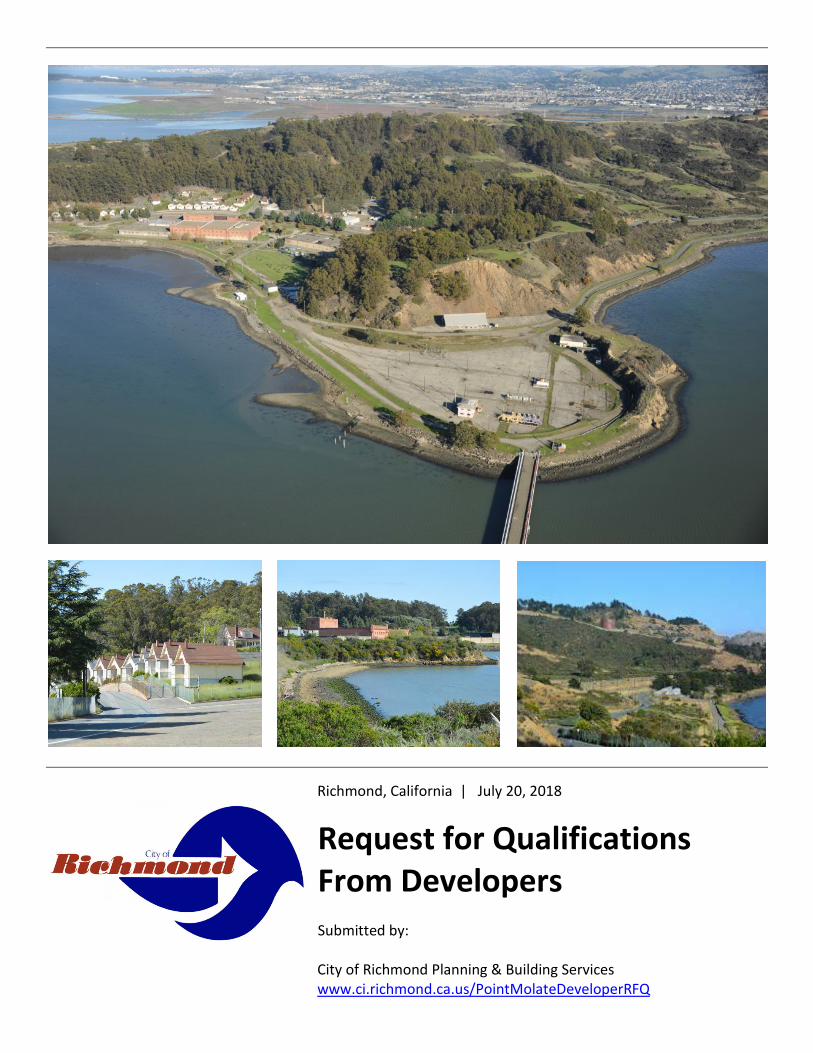
Richmond, California | July 20, 2018
Request for Qualifications From Developers Submitted by: City of Richmond Planning & Building Services www.ci.richmond.ca.us/PointMolateDeveloperRFQ

Request for Qualifications for Developers for the Point Molate Development Project
1
I. Background The City of Richmond seeks to select a qualified developer or developers, including joint ventures, to serve as master developer in a public/private partnership with the City for development of approximately 271 acres of the Point Molate property (Point Molate or site). Additionally, developers who are interested in developing discrete portions of the site are encouraged to respond, as the City expects the selected master developer to consider such other interested developers for inclusion on their ultimate development team. This request for qualifications is the first step in that two-step process. Project-specific proposals will be solicited during step two after the community land use visioning process has been completed. Point Molate is located within the City of Richmond, Contra Costa County, California on the San Pablo Peninsula approximately 1.5 miles north of the Richmond-San Rafael Bridge. Approximately 142 acres of the 413-acre project site are submerged within the San Francisco Bay.
From 1907 to 1919, the historic Winehaven winery occupied the northern portion of the project site. Beginning in 1942, Point Molate served as a U.S. Navy fuel storage and transfer facility. It closed on September 30, 1995 under the U.S. Department of Defense Base Realignment and Closure Act of 1990. A 45-member Blue Ribbon Advisory Committee developed the Point Molate Reuse Plan (Reuse
Plan), which was approved by the Richmond City Council acting as the Local Reuse Authority (LRA), in 1997. This Plan, along with the community land use visioning document, will serve as the guide for the reuse and development of the site, through which the City hopes to: Retain and promote the historic
significance of Winehaven and the other historic buildings on the property;
Create and attract job and business opportunities;
Preserve and promote the enjoyment of the natural resources of the area; and
Improve the overall quality of life for Richmond residents.
A Final Environmental Impact Report (EIR) was certified on March 8, 2011 which evaluated several alternative developments for the Point Molate site that met the goals of the Plan. The Point Molate Final EIR can be accessed at https://www.ci.richmond.ca.us/1863/Point-Molate-Resort-and-Casino. The previously proposed resort and casino project at Point Molate was not approved by the City and is not being considered. In April 2018, after lengthy litigation and resolution by the parties, the United States District Court entered a judgment (2018 Judgment) which resolved a legal dispute over the future use of Point Molate. The 2018 Judgment requires that the city must provide certain discretionary approval by April 12, 2020, and market the Development Areas for sale to one or more qualified developer(s) or builder(s) using commercially reasonable efforts by April 12, 2022, or within 24 months of the City issuing the discretionary approvals. The full 2018 Judgment is available here: http://www.ci.richmond.ca.us/DocumentCenter/View/46308/2018-04-12-Judgment-On-Claims-dckt-361_0?bidId Information regarding the Point Molate site discussed in this RFQ is available on the City’s website at
Photo by Don Figure 1 - Photo by Don Gosney

Request for Qualifications for Developers for the Point Molate Development Project
2
http://www.ci.richmond.ca.us/270/ Point-Molate unless stated otherwise.
A. Status of Ownership and Conveyance
The City currently owns and maintains the 413-acre site. The City originally acquired the project site from the U.S. Department of the Navy in two separate conveyances, the first 85 percent of the project site was transferred to the City pursuant to the Base Realignment and Closure (BRAC) process in September 2003, while the remainder of the project site was transferred to the City in March 2010 as provided in the 2008 Early Transfer Cooperative Agreement between the U.S. Department of the Navy and the City. Accordingly, the City assumed the responsibility for implementing and supervising the hazardous materials remediation using Navy funds. As described below, this remediation is in progress. I I Development Opportunity The 271-acre potential development site at Point Molate is one of the last unoccupied Bayside properties large enough to accommodate a significant development with views of the Bay and the San Francisco skyline. Given its previous developed uses, the property is served by an existing roadway access to I-580. Additionally, much of the lower slopes have been previously graded and developed. The existing fuel pier, which extends 1,450 feet from the shoreline into the Bay, provides a unique opportunity for a new ferry terminal to usher potential residents and visitors to and from the development and San Francisco, and other destinations. A branch of the San Francisco Bay Trail that connects Point Molate to Point Richmond and Marin County will be completed this year. As described further below, the development site contains both gentle and steep slopes, historic buildings, a variety of bedrock and soil types, and other site opportunities and constraints. The City is currently undertaking a community visioning process that will obtain input from the local community regarding what
types of land uses should be considered at the site, while being generally consistent with the Reuse Plan. Following this community visioning process, and per the 2018 Judgment, the City will make a decision on land use entitlements for Point Molate no later than April 2020 in a manner that is generally consistent with the Plan, and the community visioning. In 2012, the Reuse Plan was incorporated in large part into the City’s General Plan 2030. The Reuse Plan contemplates a development scenario at Point Molate with 670 residential units and preservation of at least 70 percent of the 271 acres at Point Molate as open space. The precise number, density, and location of any residential units at Point Molate will be determined during the public process, however, a minimum of 670 residential units are required by the 2018 Judgment. These units must comply with the City’s inclusionary housing ordinance. In addition, the Winehaven Historic District, listed on the National Register of Historic Places, must be preserved for adaptive reuse.
The community land use visioning process kick-off last month and is anticipated to be completed by October 2018. The Community Vision document, which will be submitted for City Council acceptance, will guide the future development of the site, and will be included in
Figure 2 - Photo by AES

Request for Qualifications for Developers for the Point Molate Development Project
3
the second-step Request for Proposals (RFP) package to solicit developer proposals. The exact location of the areas that constitute the 30% developable acreage to be sold by the City to the selected developer will be determined as part of the community visioning and entitlement process,
The Point Molate Community Visioning process aims to: Engage the community in a transparent and
inclusive process to understand how Point Molate can best serve the community of Richmond for decades to come;
Understand community needs, concerns, and priorities related to Point Molate; and,
Develop a community vision that will guide the future use and development of the property, which will be used in the second-step RFP project solicitation for short-listed qualified developers.
Interested developers are strongly encouraged to participate in and follow the land use visioning process. Information about the process and upcoming events can be found at www.richmondpointmolate.org including scheduled site tours and community forums and workshops. Site tours are planned for July 23 and August 18, 2018. Times and location information is available at www.richmondpointmolate.org
I I I Previous Environmental Studies The EIR for the Point Molate Mixed-Use Tribal Destination Resort and Casino Project evaluated several alternative developments for the site. The environmental review process began with the City, in cooperation with the Bureau of Indian Affairs (BIA), acting as Lead Agencies, initiating the preparation of a joint Environmental Impact Statement/Environmental Impact Report (EIS/EIR) to address the environmental effects of selling approximately 266 acres of the Point Molate site for the development of a tribal casino and related facilities. The Final EIR included an analysis of the following development alternatives: Alternative A – Mixed-Use Tribal
Destination Resort and Casino; Alternative B – Mixed-Use Tribal
Destination Resort and Casino with Residential Component;
Alternative B1 – “Preserve Building 6” Mixed-Use Tribal Destination Resort and Casino with Residential Component.
Alternative C – Reduced Intensity Mixed-Use Tribal Destination Resort and Casino; and
Alternative D – Non-Trust Acquisition with Non-Gaming Mixed-Use Development.
It is anticipated that a development at Point Molate would have similar constraints and required mitigation as what was determined by the Final EIR. Select summaries of potential development constraints are provided below.
A. Hazardous Materials and Site Clean-up
Due to previous land uses at Point Molate, particularly the use of the property for many decades as a Naval Fuel Depot, there are areas of hazardous materials contamination. Contaminants identified on the property included petroleum products, volatile organic compounds, metals, and others. Areas of both soil and groundwater contamination were
Figure 3 - Photo by AES

Request for Qualifications for Developers for the Point Molate Development Project
4
identified. Through previous studies associated with the base closure and transfer of the property to the City, these contaminated areas were identified, assessed, the extent and type of contamination defined, remediation plans formulated, and remediation efforts either fully or partially implemented. Regulation of remediation activities at the site has been the responsibility of the CA Regional Water Quality Control Board, and Contra Costa County. At this time, all hazardous materials sites on the property have been either closed by the applicable regulatory agency, are being regularly monitored, or are undergoing remediation or post-remediation monitoring. Point Molate is bordered to the east by the Chevron Richmond Refinery, which uses and processes various hazardous chemicals. Depending on the location and types of land uses proposed by the selected developer, land use restrictions and continued monitoring may be necessary.
B. Biological Resources
Point Molate contains a vast area of natural vegetation that could provide an aesthetically pleasing backdrop to any proposed development. The undeveloped areas of the site contains a variety of habitats including coastal scrub, eucalyptus woodland, annual grassland, and mixed riparian (refer to Figure 3.5-1 of the Final EIR, Volume II). A wetland delineation was prepared for the site in July 2007 which identified approximately 3 acres of potentially jurisdictional wetlands, 1 acre of potentially jurisdictional other waters, and 140 acres of navigable waters within the project site (refer to Figure 3.5-2 of the Final EIR, Volume II). The City adopted mitigation from the Final EIR that required avoidance of the sensitive habitats, if feasible; compliance with applicable permits (i.e. 404, 401, and 1600); and habitat mitigation by a combined 2:1 replacement/restoration ratio through the creation of an open space preserve. It is anticipated that similar mitigation requirements would apply to a new proposed project.
Analysis performed as part of the Final EIR found that the project site has the potential to support 18 special-status plant species and 23 special-status animal species (6 fish, 14 birds, and 3 mammals), however only one special-status plant has been actually documented within the project site, Suisun Marsh aster (Symphyotrichum lentum). The City adopted mitigation from the Final EIR that required avoidance of Suisun March aster, if feasible, and transplantation of the species if avoidance is not feasible. Additional mitigation was adopted for special-status bird and bat species that includes pre-construction surveys, compliance with applicable permits (take permits from USFWS and/or CDFW); and restricted use of certain lighting. Much of the site is also degraded with invasive exotics, including broom, fennel, pampas grass and eucalyptus.
C. Cultural Resources
Point Molate has a long colorful history, including use by Native Americans over thousands of years, a Chinese shrimp village (1870 to 1912-1915), the Winehaven winery (1907 to 1919), a quarry (sometime between 1924 and 1939), a Navy Fuel Depot operated by the U.S. Navy (early 1940’s to 1995), and most recently Point Molate Beach Park, currently operated by the City. Consequently, the site contains several cultural resources, most notably the Winehaven Historic District (District).
Figure 4 - Photo by AES
Figure 4 - Photo by AES

Request for Qualifications for Developers for the Point Molate Development Project
5
The Winehaven Historic District was listed on the Nation Register of Historic Places (NRHP) on October 2, 1978 and is composed of 35 buildings that together are significant historically and architecturally in the areas of wine production and industrial design. The contributing elements of the 71-acre District include 29 residences, two large winery buildings (Buildings No.1 and No.6), a warehouse (Building No.10) a powerhouse (Building No.13), a fire station (Building No.63), as well as a workshop and planning mill (Building No.17) (refer to Figure 3.6-6 of the Final EIR, Volume II for a map of the District).
Some stabilization work within the Historic District was done in 2010, but all of the buildings are at risk. The Final EIR evaluated the impacts of reusing, relocating, making alterations to, and demolishing of certain contributing elements of the Winehaven Historic District for the development of a project. The City adopted mitigation that would require development of design guidelines that would govern the rehabilitation of all retained buildings within the District as well as new construction near or within the historic core of the District. The design guidelines would incorporate the Secretary of the Interior’s Standards and would be reviewed by the City of Richmond’s Historic Preservation Commission (HPC). The 2018 Judgment entered requires that the Winehaven Historic District be preserved for adaptive reuse. In the course of disposing of the Navy Fuel Depot and deeding the property to the City, the Navy entered into a Memorandum of Agreement
(MOA) with the State Historic Preservation Office (SHPO) in 2002, with the City as an invited signatory. The MOA provided for the treatment of recognized historic properties located within the Winehaven Historic District, required the nomination of site CA-CCO-506H to the National Register, and required the evaluation of the other three resources (CA-CCO-282, -283, and -423). In the fall of 2008, an amendment to the 2002 MOA was drafted that recognizes the change in ownership of some of the cultural resources at Point Molate and clarifies the roles of the Navy and City. The amendment calls for the evaluation and, if eligible, nomination of the archaeological resources to the NRHP. The amendment also stipulates that the contributing elements of the Winehaven District must be clarified by way of an amended National Register nomination. Work undertaken by the City in 2008 included preparation of technical studies needed to address the outstanding stipulations of the amended MOA as it relates to resource evaluations, preparation of National Register nomination for qualifying resources, and District element clarification The City contemplates assigning its obligations under the MOA and the selected developer. The historic buildings are eligible for the 20% Historic Tax Credit and can be rehabilitated using the California Historic Building Code.
Figure 5 - Photo by AES
Figure 6 - Photo by AES
Request for Qualifications for Developers for the Point Molate Development Project
6
D. Infrastructure and Utilities
Infrastructure and utilities are a challenge that must be resolved by the developer. The substantial expense and complexity of providing utilities to serve each development area will require that the selected developer coordinate and finance the utility infrastructure.
Water Supply
Point Molate is within the water supply service area of East Bay Municipal Utility District (EBMUD) and is connected to the system through a 12-inch diameter water main along Stenmark Drive, which was installed in 1997. For development purposes, assume the site has no usable water distribution infrastructure other than the 12-inch diameter main.
Wastewater
Point Molate is within the wastewater service area for the Richmond Municipal Sewer District (RMSD) but is not currently connected to the District’s wastewater system. For development purposes, assume the site has no wastewater infrastructure, and treatment must be provided by a new on-site treatment system or by a new pump station and force main tying into the RMSD collection system approximately two miles away. Electrical It may be possible to actuate an existing PG&E power supply for less than $1 million, but it is undetermined what the capacity is and whether it could be used for permanent power.
E. Flood Protection
Although the site borders the San Francisco Bay, development would not be at risk for flooding during a 100- or 500-year storm. Based on FEMA flood maps dated September 30, 2015 (map 06013C0208G), the development area within the site is designated as Zone X, outside of the 100- and 500-year floodplains. Portions
of the shoreline area of the site are within Zone A, subject to 100-year flooding. The project site is not located within an area prone to flooding from a potential rise in sea level of 12 inches as mapped in April 2017 by the Adapting to Rising Tides (ART) Program, originally organized by the San Francisco Bay Conservation and Development District and National Oceanic and Atmospheric Administration’s (NOAA) office for Coastal Management.
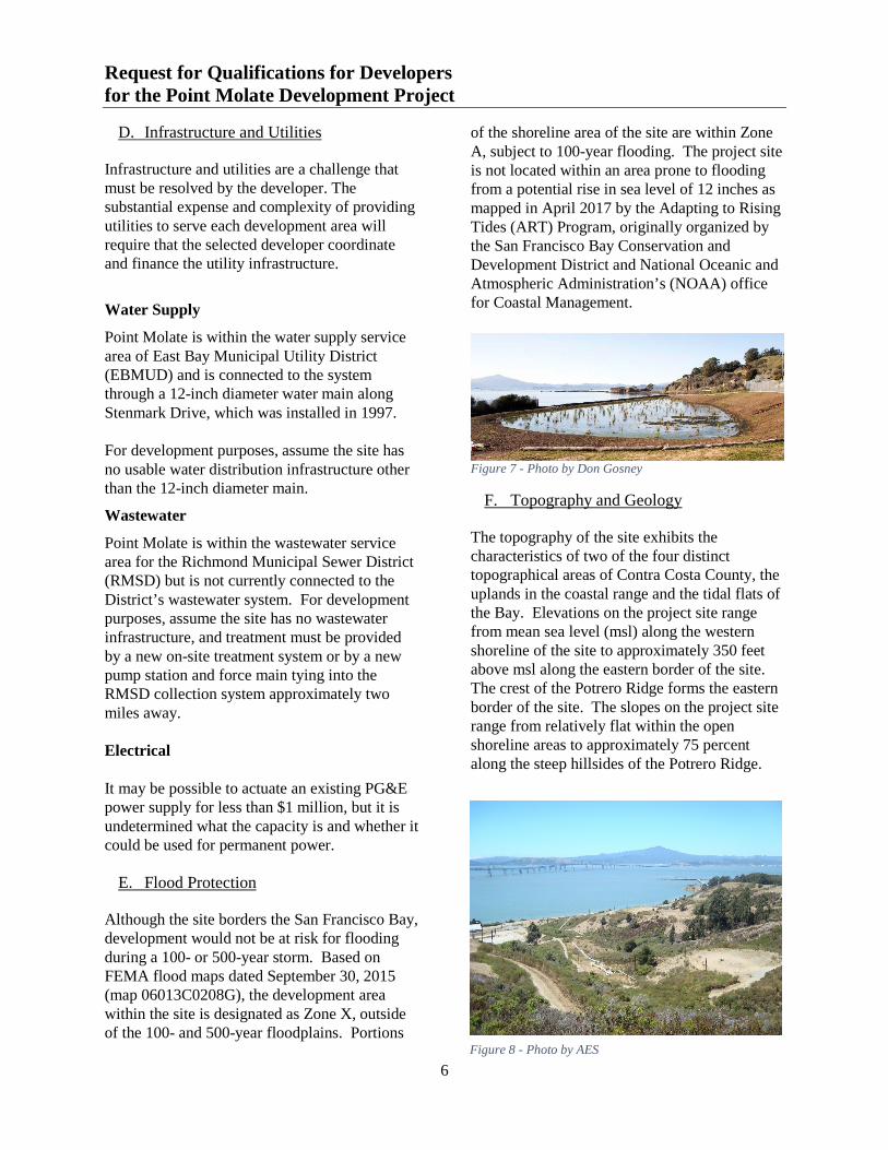
F. Topography and Geology
The topography of the site exhibits the characteristics of two of the four distinct topographical areas of Contra Costa County, the uplands in the coastal range and the tidal flats of the Bay. Elevations on the project site range from mean sea level (msl) along the western shoreline of the site to approximately 350 feet above msl along the eastern border of the site. The crest of the Potrero Ridge forms the eastern border of the site. The slopes on the project site range from relatively flat within the open shoreline areas to approximately 75 percent along the steep hillsides of the Potrero Ridge.
Figure 7 - Photo by Don Gosney
Figure 8 - Photo by AES

Request for Qualifications for Developers for the Point Molate Development Project
7
Soils on the site are not susceptible to significant sheet and rill erosion. Fill material is present along the low-lying western portions of the project site, and clayey surficial soils with moderately expansive properties are present in the southern area of the site. The site is not within an Alquist-Priolo fault zone and no known faults are present within the site. Shoreline areas within the site may be susceptible to liquefaction and lateral spreading. The Final EIR identified mitigation measures to prevent the loss of life or property as a result of development on unstable or expansive soils, which included the preparation of a geotechnical report that provides design-grade specifications for structural engineering of all new construction and retrofitting of the historic buildings.
G. Site Access
Western Drive provides direct access to the project site as well as access to the Caltrans maintenance station, and indirect access to the Chevron (DuraMaterials) Quarry at the Red Rock Cove site. Regional access to the project site is provided by exiting I-80 at Richmond Parkway or I-580 westbound. Alternatives A through D of the Final EIR included improvements to Western Drive from its intersection with I-580 through the site. As warranted by traffic volume, Western Drive would need improvements. In addition to the roadway access, the Final EIR evaluated the reuse of the existing fuel pier for passenger use and construction of a ferry terminal. It was anticipated that ferry / hovercraft service could accommodate up to 3,000 round-trip passengers per day, with up to 30 individual landings per day at the site. Since round-trip service to San Francisco was anticipated, some use of this service by commuters was expected. Currently, the pier access is silted in with water depths of as little as two meters.
H. San Francisco Bay Trail and Point Molate Beach Park
The City of Richmond, partnered with the East Bay Regional Park District (EBRPD), to design and provide CEQA clearance for two segments of the San Francisco Bay Trail (Bay Trail) that would connect with the Richmond-San Rafael bridge trail through Point Molate. The project consists of an approximately 2.5 mile non-motorized bike and pedestrian trail at Point Molate. The planned trail is comprised of Segment A and B and would be constructed in a previously disturbed area that coincides or is adjacent to the old Richmond Belt Railway corridor. Segment A would be constructed within a surface easement granted by Chevron to EBRPD for construction, operation, and maintenance of the trail. The trail is anticipated to be 10 feet wide. Construction of the trail is expected to occur in stages. The adopted Mitigated Negative Declaration and 65% construction drawings are available at the following link http://www.ebparks.org/about/ planning/#sfbt-point-molate. The City may pursue grants to implement or construct Segment B of the Bay Trail.
I. Licensing
There are three existing licenses for spaces used as dead storage (and two under negotiation) on the site. The majority of these have terms ending in 2020 and all include early termination options at the City’s sole discretion. The revenue from these licenses is currently being used to off-set City costs related to site maintenance and security.
Figure 9 - Photo by Don Gosney
Request for Qualifications for Developers for the Point Molate Development Project
8
IV Transaction Process The City will enter into an Exclusive Right to Negotiate (ERN) with the selected developer(s). The ERN will include a performance schedule that would result in an approved Land Disposition Agreement (LDA) (i.e., price and terms of payment for the land and development obligations), and an approved Planned Area Plan (i.e., detailed site plan, including backbone and in-tract street alignments and sections, building footprints and massing, land uses, development types, landscape concepts, and a phasing plan) pursuant to Article 15.04.810 of the Richmond Municipal Code. Funding for the staff review and processing of entitlements, including a General Plan Amendment, Rezoning, Tentative Subdivision Map, and Planned Area Plan application will be handled through the City’s standard planning process. V Role of Developer The selected developer will assume primary responsibility for the following aspects of development of the Point Molate site:
1. Establishing a fair, effective, and collaborative partnership with the City and Richmond community.
2. Negotiating and obtaining approval of a LDA for the site with the City during the ERN process.
3. Preparing and obtaining approval of entitlements, including a General Plan Amendment, Rezoning, Tentative Subdivision Map, and Planned Area Plan by April 2020.
4. Designing, permitting, and constructing infrastructure, landscape, and buildings during the LDA process, including obtaining site improvement, design review, and building permit approval from the City and other relevant public agencies.
5. Obtaining financing for the predevelopment, infrastructure, and development process.
6. Purchasing the property per the LDA, no later than April 2022.
VI Role of the City The City will maintain primary responsibility for the following aspects of development of the Point Molate site:
1. Negotiating exclusively and in good faith with the developer regarding a LDA for the Point Molate site. Diligently processing in the preparation of the project submittal by developer and considering approval of any proposed applications, including General Plan Amendment, Rezoning to Planned Area, Planned Area Plan, Tentative Subdivision Map, during the ERN process.
2. City intends to explore infrastructure financing options for Pt. Molate, such as Community Facilities District (CFD) and/or Enhanced Infrastructure Financing District (EIFD) financing, and complementary tools.
3. During the selection process, the City will share information received from qualified developers interested in developing discrete portions of the site (i.e., affordable housing teams) to help facilitate teams with the best possible combination of qualifications.
VII Content of Statement of
Qualifications The City welcomes a response to this RFQ in a format that the developer believes best expresses the qualifications of the development team. It is requested, however, that the statement of qualifications (SOQ) submitted clearly include, at a minimum, the elements described in this section.
1. Executive Summary. Brief synopsis of the development team’s approach to development, public/private partnerships, key qualifications, and relevant experience.

Request for Qualifications for Developers for the Point Molate Development Project
9
2. Project Understanding and Approach.
Discussion of the developer’s (a) understanding of the City of Richmond, Point Molate, and the Judgment; and (b) approach to meeting the City’s goals and objectives expressed in this RFQ and in the on-going community visioning process for Point Molate.
3. Description of Project Team. Description of the developer’s structure, designated project manager, and project management team, including the role of each team member. Please also include contact information, resumes, relevant experience, and references for each member of the project management team. Developers are required to include on their team architecture, urban design, and landscape architecture firms that will participate in the planning and development process. These firms are encouraged to have demonstrated experience in creative approaches to land use and placemaking. Please submit complete qualifications for these firms relevant to this development opportunity. No other consultant team members are requested at this time.
4. Previous Experience. Description of the specific project experience of the development entity and key individual team members in entitlements and community outreach; infrastructure development and phasing; mixed-use residential/retail development; multi-family housing; community/civic/recreational development; affordable housing; “town center” retail; waterfront development and water transportation; sustainable design and development; sensitivity to environmental protections; large-scale multi-year, infill and brownfield redevelopment; public/private financing; adherence to performance schedules, achieving and incorporating community benefits;
aggressive transportation strategies and transportation demand management; and project labor agreements and local hire programs. It is requested that the SOQ provide as much of the following information as possible for each relevant project: photos; site plans; completion date; developer structure/team; project management staff; costs and financing; lessons learned; and relevant elements to development at Point Molate. For every project, please provide specific information on sources of predevelopment funds, construction financing, long-term financing, equity funding or financing, and other working capital. Please also include references for at least five of the previous projects referenced in this section.
5. Financial Qualifications. Provision of clear evidence of financial resources to assist in the entitlement and development of Point Molate, as indicated by financial statements, and evidence of access to predevelopment, construction capital, and equity financing. Any confidential financial information shall be submitted in an envelope labeled “CONFIDENTIAL FINANCIAL INFORMATION” that will be provided to the City’s economic consultant for review and evaluation.
VII I Selection Process
1. Submittal Date and Location. Seven (7) hard copies and one electronic pdf copy of the SOQ are due at 4:00 PM on Friday, September 14, 2018 clearly marked with “POINT MOLATE SOQ.” Responses must be delivered via mail or hand delivery to:
Lina Velasco, Planning Manager City of Richmond

Request for Qualifications for Developers for the Point Molate Development Project
10
450 Civic Center Plaza, 2nd Floor Richmond, CA 94804
Please contact Lina Velasco at [email protected] with any written questions regarding this RFQ. The City’s responses to any such questions will be shared with all participants that have provided written confirmation of their intent to submit to Lina Velasco at the email address provided above. The last day to submit questions on this RFQ is August 17, 2018.
2. Review and Selection Process. The
following outlines the steps for reviewing and selecting a preferred developer:
i. Review of RFQ Responses –
September 2018 Responses to the RFQ will be reviewed and evaluated by an evaluation panel comprised of City staff, City Council members, community members, and consultants according to the criteria outlined below.
ii. Short List Recommendation –
September 2018 Based on the e v a l u a t i o n o f t h e SOQs by the evaluation panel, staff will summarize all of the responses to the City Council and recommend a shortlist of developers to the City Council in a public hearing for invitations to prepare a development proposal for the Point Molate site. This public hearing is currently anticipated in September 2018.
iii. Release RFP for Short List
A RFP will be issued and the shortlist of qualified developers will be invited to submit development proposal addressing the requirements of the RFP and
incorporating the Community Visioning document.
iv. Review of Responses to RFP
Submitted RFP responses will be reviewed and evaluated by staff and consultants. Evaluations will be provided to the City Council for consideration.
v. Public Presentation of RFP
Responses All respondents will be invited to participate in a public presentation of project proposals at a City Council meeting in November 2018. To the extent possible, please hold November 20th and 27th in the event your team is short-listed.
vi. Selected Developer Approval –
November 2018 Finally, staff will return to the City Council for approval of an ERN with a preferred developer for Point Molate, including a final negotiated Term Sheet attached to the ERN. It is currently envisioned that this action will take place in December 2018.
3. Selection Criteria. SOQs will be evaluated along with the results of the City’s due diligence and reference checks. More specifically, the criteria used to assist in the selection of a preferred developer will be:
Responsiveness to this RFQ; Evidence of relevant experience and
proven track record; Technical capability and relevant
experience of the project management team;
Evidence of financial capacity, resources, and relationships, and clear corporate/organizational structure; and

Request for Qualifications for Developers for the Point Molate Development Project
11
In depth understanding of, and reasonable approach to, the project.
IX Proposal Terms and Conditions
A. Examination of Proposal Materials
The submission of a SOQ shall be deemed a representation and warranty by the Respondent that it has investigated all aspects of the RFQ, that it is aware of the applicable facts pertaining to the RFQ process and its procedures and requirements, and that it has read and understands the RFQ. No request for modification of the provisions of the proposal shall be considered after its submission on the grounds the Respondent was not fully informed as to any fact or condition.
B. Addenda Interpretations
If it becomes necessary to revise any part of this RFQ, a written addendum will be provided through BidsOnLine. The City of Richmond is not bound by any oral representations, clarifications, or changes made in the RFQ by the City or its agents, unless such clarifications or change is provided in written addendum from the City of Richmond.
C. Questions Concerning Request for Qualifications
Interested parties may download this RFQ by visiting the City's web site, www.ci.richmond.ca.us/bids. To download the RFQ, new vendors will be required to register. Once the vendor downloads any documents relative to a solicitation, that vendor's name will appear on the Prospective Respondents list for that project and will receive any addenda or notifications relating to the RFQ. All questions must be submitted via the electronic BidsOnline system on the Q&A tab by August 17, 2018. If the City finds it necessary to issue an addendum, prospective Respondents will receive e-mail notification of addendum. Otherwise, answers to questions
received will be provided on the Q&A tab and notification will be sent by 5:00 pm PST, on August 24, 2018. It is the Respondent’s responsibility to periodically check the BidsOnline website www.ci.richmond.ca.us/bids for any possible Addenda to the RFQ that may have been posted.
D. Public Records
SOQ submitted in response to this RFQ are public record. Prospective Respondents are cautioned not to include any material into the proposal that is proprietary in nature.
E. Proposal Costs
All costs associated with the preparation of responses to this RFQ shall be borne by the Respondent. This RFQ does not constitute any form of offer to contract.
F. Reservation of Rights
The City reserves the right, for any reason, to accept or reject any one or more proposals; to negotiate the terms and specifications of the proposal; to modify any part of the RFQ; or issue a new RFQ.
G. Product Ownership
SOQs submitted shall become the property of the City.