Embed Size (px)
Citation preview

Review of mountain meteorological effects relevant to fire behaviour and bushfire risk.
Jason J. Sharples
School of Physical, Environmental and Mathematical Sciences,
University of New South Wales at the Australian Defence Force Academy
DRAFT: 17th May 2007
Abstract
Mountain meteorological effects can significantly influence the weather variables that are important to fire behaviour and the overall risk posed by a bushfire. In this paper we review the main elements of mountain meteorology relevant to fire weather and discuss the potential roles they may play in bushfire behaviour, development and risk. Introduction The influence of meteorological factors on fire behaviour has long been appreciated. Along with fuel and topography, weather variables such as temperature, relative humidity, dew point temperature, and wind strength and direction are considered the most important components determining fire behaviour and propagation. These components interact with each other in a complex manner that directly influences fire spread, fire intensity and the flammability of fuels. At the climatological scale, variations in topographic characteristics such as elevation and topographic slope and aspect are linked to spatial variations in meteorological variables, which in turn play a major role in influencing the distribution of fuel types across a landscape. At shorter time scales, topography can also affect the spatial and temporal variability of weather thereby affecting the manner in which a particular fuel type will burn. Fire behaviour and fire propagation models are often employed to account for the characteristics of a given fire. These models are highly sensitive to weather variables and thus require meteorological inputs that match those at the fire site as closely as possible. In mountainous regions, however, the spatial and temporal variations in meteorological factors can be shrouded with a high degree of uncertainty due to the complex interaction between atmospheric flows and the rugged topography. Understanding the interaction between complex terrain and atmospheric flows is thus an important and challenging endeavour which typically goes under the moniker of mountain meteorology. However, much of the literature on mountain meteorology is outside the context of fire behaviour. A principal aim of this manuscript is therefore to provide a review of some of the key elements of mountain meteorology that are relevant to fire behaviour. In addition to the problem of predicting fire behaviour and propagation, there is the broader problem of quantifying the risk of bushfires in fire-prone landscapes. Generally, risk is defined in terms of likelihood and consequence. The Australian Standard decrees that risk is the chance of something happening that will have an impact upon objectives (Standards Australia, 2004). Bushfire risk alludes to the risks inherent in fire-prone regions that arise due to the complex interactions of the various facets of the environment, where by ‘environment’ we mean to include all the natural and man-made features of the region. As the schematic in Figure 1 illustrates, the likelihood of a bushfire posing a risk in a particular region is usually separated into two components – the likelihood of ignition and the likelihood of propagation. Assuming that these two components are independent of one another, the likelihood of a bushfire posing a risk is obtained by simple multiplication of the respective probabilities pertaining to ignition and propagation. Ignition likelihood is generally broken down into the various sources of ignition, each of which is treated by the appropriate models. The schematic in Figure 1 takes a simplified view, classifying ignitions as natural (lightning induced) or otherwise. The likelihood of propagation of a bushfire is typically derived using some form of fire propagation model that combines information from fire behaviour models, with knowledge of fuels, terrain and meteorological conditions to make a prediction of where the fire is likely to spread during its evolution.
1
Likelihood Consequence
BUSHFIRE RISK
Ignition Propagation
- Lightning - Other
- Fuels - Terrain - Meteorology
- Life - Property - Ecological - Socio-Economic - Cultural
- Synoptic scale - Diurnal variation - Mountain effects
Figure 1. Simplified schematic showing the relationship between the various facets of bushfire risk.
Traditionally, fire spread models have used synoptic scale meteorological observations as inputs to predict fire growth from rate of spread calculations. The Australian Fire Danger Rating system, based on the work of McArthur (1966; 1967), is a chief example of this. More detailed models allow for diurnal variations in meteorological variables. These diurnal variations are used to appropriately perturb the broader scale observations so that finer temporal scale fire behaviour can be more adequately accounted for. When dealing with the problem of bushfire risk in mountainous landscapes, however, it is also important to understand the drivers of risk arising from the interaction of the atmosphere with the complex terrain encountered in these regions. Mountainous regions can have an influence on the wind and weather due to the strong stable stratification of the atmosphere, which inhibits vertical displacement. The effect of buoyancy will return vertically displaced air parcels to their equilibrium level even if this requires a broad horizontal excursion or the generation of strong winds. Moreover, the lower atmosphere is typically so rich in water vapour that only a relatively minor adiabatic ascent is required to bring the air to saturation (Smith, 1979).The meteorological processes endemic to high-country or mountainous landscapes can contribute significantly to the overall risk posed by a bushfire. In Europe and North America the effect of mountain meteorological phenomena on fire behaviour and the risk posed by wild fires have long been recognised. This is reflected in research and education (Byram, 1954; Ryan, 1969; Ryan 1977; Furman, 1978; Ryan, 1983; Haines and Lyon, 1990; Rothermel, 1993; Butler, et al., 1998; Conedera, et al., 1998; Millán, et al., 1998; Miller and Schlegel, 2006) conducted over the last 50 years. It is traditionally believed that the mountainous regions in Australia are not significant enough to produce the type of mountain meteorological effects conducive to increased bushfire risk. However, given the recent incidence of large fires in the Australian high country (eg. 2003, 2006/7), and the occurrence of severe fires in hilly terrain in the past (eg. The Ash Wednesday Fires), the role that mountain meteorological effects play in the overall bushfire risk problem is worthy of further scrutiny. Elements of mountain meteorology thought to be important for bushfire risk in the Australian high-country, which are all summarised here and will be discussed in detail later, include mountain winds such as foehns and mountain jets, dynamic channelling, atmospheric drying and interactions with the terrain that
2
contribute to local atmospheric instability. Foehn winds are strong, dry winds caused by the adiabatic compression of air flowing down lee slopes of mountain barriers. They are characterised by high wind speeds and low atmospheric moisture levels, both of which serve to exacerbate bushfire risk. Foehn winds occurring after long periods of drought or dry weather can result in extreme fire behaviour. Jets are narrow currents of fast-moving air that have a distinctive jet wind-speed profile. The most familiar example is perhaps the subtropical jet stream, located near the top of the troposphere. However, jets can also exist much lower in the atmosphere, in some cases only a few hundred metres above the ground. These are referred to as Low Level Jets (LLJs). Nocturnal LLJs often form as an inertial response to the sudden removal of ground friction at sunset, as a consequence of the decoupling created by the ground inversion that arises during the night as convection decays. For the case of the Australian high-country, nocturnal LLJs can result in the influx of drier air at high wind speeds, leading to peak fire danger between midnight and dawn when fire managers would normally expect mild conditions. Dynamic channelling can occur via a number of processes. Forced channelling diverts the bulk winds into incised valleys along a path of least resistance while pressure-driven channelling causes wind to flow into incised valleys in response to a pressure gradient. Lee-slope eddies can produce similar effects to channelling, but are based on the pressure difference along a steep lee-slope rather than that in an incised valley. Channelling events are characterised by high local wind-speeds in directions roughly perpendicular to the bulk winds. This can lead to expansion of flank fires up appropriately aligned valleys (essentially the flank is turned into a rapidly propagating head fire) and can result in a large number of spot fires that compromise control initiatives. Local atmospheric drying and instabilities can also lead to localised extreme fire behaviour that can result in the formation of ember storms or a plume-driven fire. To properly assess how mountain meteorological effects contribute to bushfire risk in the Australian high-country it is prudent to begin with a review of the available international literature dealing with the topic of wildland fire risk or fire propagation in mountainous areas. Given that the mountain meteorological effects discussed above have only recently become of interest to Australian fire managers, it is worthwhile to identify other fire-prone regions around the world that are likely to experience similar mountain effects. Examples of these regions include those parts of the United States that lie immediately east of the Rocky Mountains (California is a prime example) and in certain mountainous regions in Europe where, for example, the dangers of foehn winds are well known. Moreover, it is useful to review what is known about how these mountain effects contribute to fire behaviour in these regions and how this might translate to the Australian case. Such a review will also aid in identifying gaps in knowledge about mountain effects and fire behaviour and is also likely to shed light on the placement of monitoring stations in order to capture these meteorological phenomena. Elements of mountain meteorology relevant to bushfire In this section we provide a brief description of some of the main mountain meteorological phenomena that have the potential to impact on fire behaviour and the risk posed by bushfires in mountainous areas. In doing this we will concentrate on mountain effects that can significantly alter the key meteorological variables relevant to fire behaviour, i.e. temperature, atmospheric moisture, wind speed and direction and atmospheric stability. Topographically Induced Variations in Temperature and Humidity The amount of solar radiation reaching a point on the surface in mountainous terrain can vary significantly depending on the topographic slope and aspect and local relief. The insolation of a patch of land is a key factor in determining its microclimate, which includes its temperature, humidity, soil moisture and vegetation. Geiger et al. (1995) demonstrated that under full sunshine in the midlatitudes of the northern hemisphere, south facing slopes are on average 3oC warmer than north facing slopes. South facing slopes also experienced lower relative humidity and lower soil and vegetation moisture content. It is reasonable to expect analogous results for north facing slopes in the southern hemisphere, although it is important to note that shadowing of lower elevations by higher peaks and ridges can confound this effect. The passage of the
3

sun during the day also leads to diurnal variations in the exposure of slopes and hence in the levels of temperature and relative humidity associated with them. However, it is important to note that McCutchan and Fox (1986) found that strong winds can negate any differences due to slope, elevation or aspect present at low wind speeds. Diurnal variations in temperature also generate mountain winds (see the next section). The variability of elevation, slope and aspect across an area containing mountainous terrain can therefore lead to a large degree of spatial variability in temperature and relative humidity across such landscapes (Cramer, 1972; McCutchan, 1976; McCutchan and Fox, 1981; 1986). The elevation of a surface directly influences its temperature and relative humidity (McCutchan, 1976). Typically, in a well mixed daytime atmosphere, temperature decreases with height in the boundary layer whereas the mixing ratio changes little with height (Whiteman, 2000). Hence with increasing height there is a tendency for relative humidity to increase. This means that, under these conditions, surfaces at higher elevations have lower temperatures, higher relative humidity and higher moisture content in the soil and vegetation. At night, temperature inversions and cold air drainage can cause the relationship between temperature humidity and elevation to reverse, leaving upper slopes with higher temperatures and lower humidity than the lower slopes and valley bottoms. The elevation dependent linear regression analysis of mean monthly temperatures conducted by Pielke and Mehring (1977) suggests that elevation and temperature are most correlated during summer months, whereas low level inversions encountered in winter introduce greater variability. While the effects of elevation and aspect determine mean seasonal temperature values in mountainous areas, there is also some indication that short term deviations associated with synoptic weather events are not so influenced (Barry, 1992; Furman, 1978). The partial spline analysis of Hutchinson (1991) derived an temperature-elevation lapse rate of approximately 6oC per kilometre in Australia. Above the boundary layer, relative humidity drops rapidly. For moderate topography this is not important as mountains typically remain wholly within the boundary layer. However, certain extreme situations occur where dry upper air can penetrate to lower levels. In these instances mountainous regions are particularly prone to sudden decreases in relative humidity, owing to their height. More will be said about these types of phenomena in later sections. Inversions can also have a significant effect on temperature and atmospheric moisture in mountainous terrain. Under inversion conditions, mountain valleys can experience low temperatures and higher fuel moisture content. When daytime heating begins to break up a nocturnal inversion the induced mixing can cause temperatures to increase, humidity to decrease and wind may increase in strength and change direction suddenly. Particular types of inversions known as subsidence inversions, which typically occur during summer months, are produced by subsiding high pressure centres. As midtropospheric air sinks it is warmed and dried due to adiabatic compression and eventually replaces the surface air, which is forced out as subsidence progresses. Mountaintops are particularly prone to the warming and drying effects of subsidence inversions and can thus be subject to meteorological conditions that are quite different to those simultaneously experienced at nearby low-land sites. Marine inversions can also lead to differences between meteorological conditions at low-land and elevated sites. In these cases the inversion is caused by the intrusion of cool, moist marine air over the low-lands and into mountain valleys. Conditions at elevated sites above the marine inversion can be much warmer and drier. These types of inversions are restricted to coastal zones with cold ocean currents offshore. Diurnal Mountain Winds The thermal properties of any particular portion of the Earth’s surface vary diurnally. In mountainous terrain this diurnal variation causes a cycle of upslope and downslope winds. Technically these winds are referred to as anabatic (upslope) and katabatic (downslope) winds. The terms ‘anabatic wind’ and ‘katabatic wind’ are used most often in mountain meteorology to describe the upslope and downslope winds that arise due to heating and cooling of the slope surfaces during periods of light geostrophic winds. However, they are often applied more generally to other slope winds that act on a variety of scales, thus leading to ambiguity and confusion. The thermally driven anabatic and katabatic winds arise as a
4
consequence of thermally induced pressure gradients between the air near the elevated surface and air at a similar altitude over lower lands (McCutchan, 1983; Sturman, 1987). The various anabatic and katabatic winds form the mountain wind system, which follows a diurnal cycle. This system is composed of four separate wind systems (Whiteman, 2000)
• Along-slope wind system: These winds are driven by horizontal temperature differences between the air near the elevated slope surface and air at similar altitudes over lower lands. At night, when the surface cools, this results in a pressure excess which drives winds downslope. Such downslope winds can also be caused by cold surfaces such as ice or snow. During the daytime, the surface heats and the pressure gradient forces air to move upslope.
• Along-valley wind system: These winds are driven by horizontal temperature differences along the
valley axis. During the daytime winds tend to blow up the valley, while at night the winds blow down the valley.
• Cross-valley wind system: These winds flow perpendicular to the valley axis and are caused by
temperature differences between the sidewalls of the valley. These temperature differences can be caused by differences in insolation of the two sides of the valley arising due to the relation of the topographic aspect of the valley sidewalls and the position of the sun. These winds blow toward the valley sidewall experiencing the most heating.
• Mountain-plain wind systems: These are winds that arise due to temperature differences between
the air over a mountain range and the air over a neighbouring plain. These winds are typically larger in scale. They tend to blow up the mountain slopes during the day and downslope during night.
It is important to note that the characteristics of diurnal winds can be effected by the ambient meteorology and inherent circulations governed by the terrain (Gudiksen, 1989; Gudiksen, et al., 1992).
Dynamic Channelling Channelling of airflows along valleys in mountainous regions can arise as a consequence of the interaction of upper winds with the complex topography encountered in such regions. These interactions have been studied extensively in recent times in connection with the problem of predicting the dispersion and impacts of pollutants released from the ground, or from elevated smokestacks, in and around populated mountain valleys (Doran and Whiteman, 1992; Whiteman and Doran, 1993; Weber and Kaufmann, 1995; Kaufmann and Weber, 1996; Weber and Kaufmann, 1998). In this context it is interesting to note that smoke from bushfires or from prescribed burning activities also qualify as pollutants. These studies have identified four separate mechanisms resulting in the formation of valley winds (Whiteman and Doran, 1993):
• Thermal Forcing • Downward Momentum Transport • Forced Channelling • Pressure-driven Channelling
As already mentioned above, thermally forced valley winds are a feature of many valleys that result from temperature differences along the valley axis. These temperature differences induce pressure gradients that drive the valley winds. Thermally driven valley winds typically follow a diurnal cycle, with up-valley winds occurring during daytime hours and down-valley winds occurring during the night-time in accordance with diurnal variations in surface heat fluxes (Whiteman, 1990). These winds are particularly prominent when upper winds are weak. Winds within a valley can also arise as a consequence of the downward transport of horizontal momentum from above the valley. Downward transport can occur due to vertical mixing caused by convective
5

turbulence or by gravity waves that arise due to variations in buoyancy (Whiteman and Doran, 1993). Conservation of momentum dictates that the direction of valley winds caused by downward momentum transport will be similar to the direction of the upper winds. However, because of friction, a slight redirection of the upper winds of approximately 25o towards lower pressure can be expected near the ground surface (Doran and Whiteman, 1992). Valley winds driven by the downward transport of momentum are most likely to occur over terrain of mild relief when atmospheric instability is high. Forced channelling of the upper wind results when the side-walls of the valley cause anisotropic friction, which is much less in the along-valley direction than it is in the across-valley direction. This difference in friction forces the wind to align preferentially along the valley axis, as is illustrated in Figure 2. The direction and strength of the resulting channelled flow depend on the sign and magnitude of the component of the upper winds relative to the valley axis. Under ideal conditions, the induced valley winds can undergo an immediate change in direction of 180o as the upper wind direction changes across a line perpendicular to the valley axis (Doran and Whiteman, 1992; Whiteman and Doran, 1993, Kossmann, et al., 2001, Kossmann and Sturman, 2002; 2003).
Valley Axis
Valley Side-walls Valley Wind
VW
GWGeostrophic
Wind
Figure 2. Forced channelling along a valley. The geostrophic wind vector WG, assumed at ridge height, blows across a at some angle. The surface wind vector within the valley WV occurs due to the deflection of the geostrophic
y the valley side-walls. The winds are forced along the valley. valleywinds b
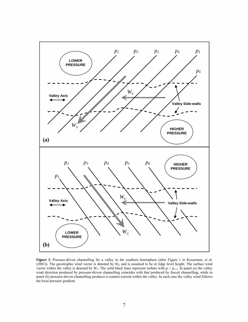
Pressure-driven channelling, a mechanism initially proposed by Fiedler (1983), and investigated by Eckman, et al. (1992), Eckman (1998) and Kossmann, et al. (2001), is driven by the component of the geostrophic pressure gradient along the valley axis. This is illustrated in Figure 3. Consequently, valley winds arising from pressure-driven channelling will switch direction by 180o whenever the pressure gradient vector crosses a line perpendicular to the valley axis. Thus, in contrast to forced channelling, valley winds resulting from pressure-driven channelling will switch direction by 180o whenever the upper wind direction crosses a line parallel to the valley axis. Pressure-driven channelling can therefore result in counter-currents (Wippermann and Gross, 1981; Wippermann, 1984; Gross and Wippermann), which flow in opposition to the main component of the upper winds. An example of the pressure-terrain configuration required for development of a counter-current valley wind is given in panel (b) of Figure 3.
6
p1 p2 p3 p4 p5
p6
LOWER PRESSURE
HIGHER PRESSURE
GW
VW Valley Axis
Valley Side-walls
(a)
(b)
p2 p3 p4 p5 p6
p1
HIGHER PRESSURE
LOWER PRESSURE
GW
VW Valley Axis Valley Side-walls
Figure 3. Pressure-driven channelling for a valley in the southern hemisphere (after Figure 1 in Kossmann, et al. (2001)). The geostrophic wind vector is denoted by WG and is assumed to be at ridge level height. The surface wind vector within the valley is denoted by WV. The solid black lines represent isobars with pi < pi+1. In panel (a) the valley wind direction produced by pressure-driven channelling coincides with that produced by forced channelling, while in panel (b) pressure-driven channelling produces a counter-current within the valley. In each case the valley wind follows the local pressure gradient.
7

Kossmann, et al. (2001) note that only a few observations are available to support the concepts of forced and pressure-driven channelling, and so for most topographic configurations it is still unclear which concept best describes the dynamically channelled airflows correctly. This is particularly true in the Southern hemisphere. Observational studies in the Northern hemisphere suggest that pressure-driven channelling is mainly responsible for the modification of large scale winds in broad and long valleys (Wippermann and Gross, 1981; Whiteman and Doran, 1993) whereas forced channelling seems to mainly occur in small valleys, mountain passes or saddles (Weber and Kauffmann, 1998). A study by Smedman, et al. (1996), who considered airflows in an intermediate valley, suggests that forced and pressure-driven channelling can even occur in combination, enhancing or counteracting each other depending on the direction of the upper winds. Moreover, Croxford (1997) notes that the presence of thermally induced valley winds further complicates the task of diagnosing which type of channelling process is at play. Further work by Kossmann and Sturman (2002; 2003) has extended the study of channelling effects to curved valleys, which are commonly present in real landscapes. In the case of strong geostrophic winds, airflows resembling dynamic channelling can also occur along lee slopes in mountainous terrain, even without the presence of a definite valley. In these instances, the winds are forced up and over ridge lines often resulting in flow separations or separation eddies in the lee of the ridge. These horizontal-axis eddies can extend along the entire length of the ridge (Whiteman, 2000). Such features are a consequence of the partial decoupling of the geostrophic winds and the near-surface winds in the lee of the ridge line (Lee, et al., 1981; Byron-Scott, 1990, Papadopoulos, et al., 1992). The partial decoupling of the near-surface and upper winds in the lee of ridge lines also permits air to flow horizontally in a direction dictated by local pressure gradients or thermal influences, essentially independent of the geostrophic wind direction. The net effect is for the air to follow a spiral or corkscrew pattern about a horizontal axis aligned approximately parallel to the ridgeline. Such a process is typically referred to as a lee-slope rotor or lee-slope eddy (Byron-Scott, 1990), but given the possibility of lateral flow within these structures, the process could be termed lee-slope channelling. Foehn Winds Foehn winds (also written föhn) are a common meteorological feature found in the lee of many mountainous regions (Barry, 1992; Rasilla, 1998). When synoptic conditions are favourable, the effects of complex topography can alter the mechanical and thermodynamic properties of airflows resulting in these distinctive flows down the lee slopes of mountain ranges. In general terms, according to Brinkmann (1971), a foehn wind is a strong, warm, dry wind descending in the lee of mountain ranges. The generic term originates in Europe in connection with the warm, dry winds experienced on the northern slopes of the Alps, though it is interesting to note that the word ‘foehn’ derives from the Greek word for fire (Miller and Schlegel, 2006a). Foehn winds are also known by various local names throughout the world. Examples include the Chinook winds of the northwest United States, the Santa Ana winds of southern California, the diablo winds of northern California, the north foehn and south foehn of the Alps, the oroshi of Japan, the Canterbury northwester in New Zealand and the Suradas in northern Spain (Brinkmann, 1971; Rasilla, 1998). As already mentioned, foehn winds are characteristically strong, warm and dry. Brinkmann (1974) reports that chinook windstorms at Boulder, Colorado have been accompanied by temperature rises of up to 15-20oC, while Ryan (1991) recounts a Santa Ana occurrence in 1859 where temperatures on the Californian coast rose from 29oC in the late morning to a record setting 56oC by 2pm! Associated wind speeds can exceed 100 km h-1 and have even been recorded as high as 160 km h-1 (Brinkmann, 1974; Miller and Schlegel, 2006a). It is not uncommon for relative humidity to suddenly drop to single digits during foehn conditions. The classical mechanism attributed to foehn winds involves the forced ascent of moist air due to a mountain range. As the air rises on the windward slopes due to forced ascent, moisture is condensed and thus removed from the air, often as precipitation. The latent heat release accompanying the condensation warms the ascending air. On the lee slopes the descending, dry air warms further due to adiabatic
8

compression. Since the saturated adiabatic lapse rate (approx. 5-6oC/km) is lower than the dry adiabatic lapse rate (approx. 10oC/km) the process results in higher potential temperatures on the lee side of mountain ranges (Hann, 1866; Hann 1867; Barry, 1992). However, as noted by Hann (1885), foehn winds may occur without moisture removal on the windward side since adiabatic compression of the descending air on the lee side will result in relatively warmer temperatures and lower relative humidities. This can occur, for example, when mountain ranges block low level airflows capped by an inversion. Such instances have been studied in the United States by Cook and Topil (1952) and Brinkmann (1973; 1974), in the British Isles by Lockwood (1962) and in Europe by Seibert, (1990) and Ustrnul (1992). In more general terms a foehn wind can be characterised as a consequence of the barrier effect of mountains. Blocking of airflows can persist until changes in the large-scale pressure gradient forces the air from one side of the mountain to move over the crest and down the other side (Smith, 1979). Specifically defining a foehn wind is a problem of some importance since it has bearing on the calculated frequency of foehn conditions within a particular region. Throughout the literature a number of criteria have been used to distinguish ‘foehn conditions’ (Brinkmann, 1971; Barry, 1992). Yoshino (1975) defines a foehn wind in simple terms as a downslope wind that increases the temperature on the lee side of a mountain range. Other criteria in the literature include arbitrarily setting a maximum temperature to be exceeded (Longley, 1967), the presence of local, unusually high temperatures for a given season (Lockwood, 1962), requiring precipitation on the windward side of the mountains (Ives, 1950) and the existence of isentropic conditions (Schuetz and Steinhauser, 1955). Commonly though, three criteria are used to distinguish foehn conditions at stations in the lee of mountains (Osmond, 1941; Frey, 1957):
• surface winds blowing from the direction of the mountains; • an abrupt temperature rise; and • a simultaneous drop in relative humidity.
However, since a temperature rise is often accompanied by a drop in relative humidity, the last two criteria are hard to separate. It is therefore perhaps better to alter the last condition above to be ‘a simultaneous drop in dew point temperature’. Attempts have also been made to link the presence of foehn conditions with specific synoptic conditions. Beer (1974) asserts that both cyclonic and anticyclonic foehns exist. Cyclonic foehn conditions develop only when a steep pressure gradient exists across a mountain range, which arises due to a high pressure ridge on the windward side and a low pressure trough in the lee (Beer, 1974; Hoinka 1985; McGowan and Sturman 1996). Synoptic precursors for the Santa Ana foehn involve a strong pressure gradient between the Great Basin and the southern Californian coast. These conditions are typified by the presence of a high pressure system over the Great Basin which reverses the normal pressure gradient that causes winds to blow off the ocean (Whiteman, 2000). Such conditions are distinctive and easily forecast. Similarly, Lockwood (1962) found that foehn conditions in North Wales and Scotland were strongly tied to the presence of warm high pressure systems to the east of the British Isles. Brinkmann (1970), while studying the chinook foehn, required that the upper flow should be approximately perpendicular to the main orientation of the mountains and that the surface pressure field should display a ridging over the mountains. This ridging is typically referred to as a ‘foehn nose’. The use of such synoptic criteria, however, appears to be complicated by the influence of meteorological phenomena endemic to the particular region. In the case of the chinook, the presence of stable pools of cold air in the Great Basin can diminish the distinctiveness of the foehn nose (Brinkmann, 1971). In the anticyclonic foehn there is no foehn nose, which suggests that the foehn effect is due to dry subsiding air driven by the presence of a high pressure system in the lee of the mountains (Beer, 1974). It is interesting to point out the similarities between the anticyclonic foehn and the effects of a subsidence inversion on elevated terrain. The theory of lee mountain waves affords another criterion for the occurrence of foehn conditions. Scorer and Klieforth (1959) assert that airflows will be blocked upstream by mountain barriers if the ridge height exceeds π/l, where l is a stability factor known as Scorer’s parameter (Scorer, 1949) defined as (Beer, 1974; Barry, 1992):
9

2
2
2
22 1)(
zU
UUNzl
∂∂
−=
where N = N(z) is the frequency at which a displaced air parcel will oscillate when displaced vertically within a statically stable environment (Brunt-Väisälä frequency), and U = U(z) is the vertical profile of the horizontal wind speed. Beran (1967) found that the mountain barrier height exceeding π/l was a necessary but not a sufficient condition for predicting the occurrence of the chinook in Colorado, while Lockwood (1962) found that in the majority of cases in the British Isles foehn conditions occurred when π/l was equal to or slightly exceeded the mountain height. Foehn conditions are often accompanied by distinctive cloud formations that find their way into local weather lore as predictors of foehn winds. Examples of these include orographic clouds such as the foehn wall and mountain wave clouds such as the chinook arch. The foehn wall (sometimes called a chinook wall in North America) is the leeward edge of an extensive cloud sheet that forms along the ridge tops of mountain ranges as moisture condenses out of air being lifted up the windward slopes. It is indicative of the classical foehn mechanism espoused by Hann (1866) and discussed above. The chinook arch is an extensive layer of altostratus cloud that forms downwind of the mountains in the rising portion of a standing lee mountain wave. An observer standing under the cloud looking towards the mountains would see a layer of clear air between the cloud and the mountain tops. The base of the cloud appears to arch due to perspective, thereby giving rise to its name. Cyclonic foehns are often accompanied by lee wave clouds, which will be discussed in later section (Beer, 1974). Research into foehn phenomena is still an active area of mountain meteorological research (Tschannett and Furger, 2006). Low-Level Jets A jet is defined as a narrow current of fast-moving air. A jet is distinguished by a jet wind speed profile, which is a vertical wind speed profile characterized by a relatively narrow current of high winds with slower moving air above and below. A large wind shear occurs above and below the jet axis. Figure 4 is a typical example of a jet wind speed profile. Jets exist at different levels of the troposphere and vary in strength, width and length. Familiar examples include the subtropical jet stream, which is found at some longitudes, between 20° and 30° latitude, and the polar frontal jet. The subtropical jet can exhibit wind strengths of up to 360 km h-1 and can extend for thousands of kilometres in length and hundreds of kilometres in width (Davies, 2000). Jet phenomena are also observed much lower in the atmosphere, sometimes as low as 100 m above the ground (Banta et al., 2002). These types of jet phenomena are referred to as low-level jets. The prevalence of low-level jets is now widely accepted (Wexler, 1961; Browning and Pardoe, 1973; Sládkovič and Kanter, 1977, Brook, 1985). A southerly or southwesterly low-level jet frequently occurs during night time and early morning over the Great Plains of the United States (Bonner, 1968; Whiteman, 2000). Such night time jets occur throughout the world (Gerhardt, 1962; Thorpe and Guymer, 1977; Hsu, 1979; Dickison and Neumann, 1982; Drake, 1985) and are termed nocturnal low-level jets. The most commonly cited mechanism for the formation of a nocturnal low-level jet involves a decoupling of the flow just above the surface, as a result of cooling near the ground after sunset. This decoupling from the frictional forces near the ground produces an acceleration of the flow above the atmospheric surface layer (Blackadar, 1957; Thorpe and Guymer, 1977; Singh et al., 1993; Banta et al., 2002). The acceleration produces a vertically narrow layer of fast moving air that often exhibits a maximum in the vertical wind speed profile within a few hundred metres of the ground surface. Studies suggest that the low-level jet formed through this mechanism would produce a wind speed maximum approximately 8 hours after the effects of turbulent mixing cease in the early evening (Hoxit, 1975; Stensrud, 1996). Reiter (1963, 1969),
10

however, argues that jet-like vertical profiles produced by the mechanism described above should be named inversion wind maxima rather than low-level jets.
0
300
600
900
1200
1500
1800
2100
2400
2700
3000
0 2 4 6 8 10 12 14 16 18
Wind Speed (m/s)
Hei
ght (
m A
GL)
Figure 4. A typical jet wind speed profile. In this case, the jet would qualify as a low-level jet.
Nocturnal low-level jets can also form through other mechanisms. For example, they can result from synoptic pressure gradients or baroclinicity produced in inclined boundary layers over sloping terrain. In regions where there is a significant change in surface characteristics the horizontal differences in sensible and latent heat fluxes produce strong baroclinicity with the planetary boundary layer. This can produce low-level jets through strong geostrophic forcing, where the low-level jets are oriented parallel to the low-level horizontal temperature gradient (Stensrud, 1996; Bonner and Peagle, 1970). Bleeker and Andre (1951) proposed a similar mechanism based on horizontal differences caused by variations in elevation. This mechanism is the same as that described in the along-valley wind system section above and can produce jet-like vertical wind profiles during the night time. Terrain can also produce jet-like winds when airflow is accelerated through narrow passes (Pamperin and Stilke, 1985; Macklin et al., 1990; Stensrud, 1996). Paegle, et al. (1984) show that nocturnal low-level jets can also be produced through the effects of terrain blocking due to stable stratification at night. Nocturnal low-level jets can cause distinctive fluctuations in temperature and atmospheric moisture, in addition to wind speed (Izumi and Barad, 1963; Izumi, 1964; Izumi and Brown, 1964; Kaimal and Izumi, 1965). Izumi (1964) demonstrates that upper level temperature increases in the hours before sunrise are commonly associated with low-level jet occurrence. These upper level temperature increases, which tend to occur at the same time as intermediate levels are undergoing cooling, are probably due to subsidence associated with the low-level jet or with intermittent mixing due to generation of Kelvin-Helmholtz shear waves. Izumi and Brown (1966) report significant changes in temperature and atmospheric moisture at upper levels during nocturnal low-level jet occurrence. The onset of the nocturnal low-level jet is accompanied by a period of abrupt warming and drying of the atmosphere at upper levels, followed by a long period of elevated temperature and wind speed, and decreased atmospheric moisture. Nocturnal low-level jets also play an important role in the transport of atmospheric quantities during night time. Banta et al. (1998) showed that nocturnal low-level jets significantly effect the movement of pollutants through the atmosphere. The wind shear generated by nocturnal low-level jets is also likely to play a part in controlling fluxes between the surface and upper atmosphere (Banta et al., 2002). It is important to note that while in many cases low-level jet phenomena are not, strictly speaking, mountain meteorological phenomena, elevated terrain downwind of the region of jet formation are more susceptible to their effects. Indeed, jet phenomena occurring in the lower parts of the troposphere are more
11

likely to intersect elevated ground in mountainous terrain than low lying areas. It should also be pointed out that a number of alternative mechanisms that account for jet-like profiles have been proposed. For example, synoptic cold fronts, sea-breeze fronts, post-cold-frontal jets and gust fronts associated with thunderstorms can exhibit a low-level jet wind speed profile. The use of the term ‘low-level jet’ to describe any low-level maximum in the vertical wind speed profile has led to ambiguity in the way the term is applied in the literature. Mountain Waves and Other Meteorological Phenomena Deflection or perturbation of airflows by mountainous terrain can result in a number of different phenomena. These include mountain wind waves, induced instability and thunderstorms. In a stable atmosphere, air flowing over a mountain barrier can produce mountain wind waves. These are a form of gravity, or bouyancy, wave that results from the effects of gravity on variations in air density. As a parcel of stably stratified air rises over a mountain it cools, becomes denser than the surrounding air, and thus begins to sink in the lee of the mountains. This descending parcel can often overshoot into regions where it is less dense than the surrounding air, which again causes it to ascend. The net result is an oscillation of the airflow about some equilibrium level. As these mountain waves appear in the lee of the mountain barrier they are often referred to as lee waves. In complex topography, where multiple barriers are present, waves generated by one ridge can be amplified or dampened by further downwind barriers, depending on the height of the successive barriers, the distance between them and the wavelength of the mountain wave. When sufficient moisture is present, lee waves can produce distinctive cloud patterns as can be seen in Figure 5. Types of wave clouds include cap clouds, lenticularis and rotor clouds. Lee waves are often confined vertically by a smooth horizontal flow above, which traps the wave; hence the term trapped lee wave. Mountain waves, however, can also propagate vertically, extending throughout and even beyond the troposphere (Gill, 1982; Whiteman, 2000). In general the characteristics of lee waves will depend on a number of factors including the vertical profile of the wind, the geometry of the mountain barrier and the stability of the atmosphere (Barry, 1992; Whiteman, 2000).
Figure 5. MODIS image from 1st September 2006 showing lee mountain waves over the Australian Capital Territory. In this case the waves are being generated by a high ridge that runs north-south just to the left of the middle of the image.
12

Under certain stability, flow and topographic conditions, large scale instability can cause the mountain wave to undergo an abrupt change into what is termed a hydraulic flow. Hydraulic flow is characterised by a region of wave-breaking aloft, a sudden jump in the streamline patterns, high wind speeds on the leeward slopes, a cavity at the bottom of the slope and severe turbulence immediately beyond the cavity (Lilly, 1978; Whiteman, 2000). Regions where lee waves are breaking would tend to more neutrally stable conditions and could provide a mechanism for the transport of dry upper air to lower altitudes. Recent research (Mills, 2005; 2006) has linked the dramatic lowering of near-surface humidity to the passage of regions of very dry air in the upper atmosphere. The processes that lead to the exchange of this air with the surface require further investigation. In an unstable atmosphere terrain-driven mechanisms can also lead to the development of convective cells and thunderstorms. Thunderstorms and convection are common features over many mountain ranges throughout the world. Mountainous terrain can cause orographic lifting of airflows either by vertically deflecting horizontal flows or by anabatic flows induced by daytime heating, which result in updrafts in the vicinity of mountain peaks. These can result in the formation of convective cells and thunderstorms. Channelling of airflow by ascending valleys and lee side convergence of horizontally displaced airflows can also generate thunderstorms and induce further instability. Effects on fire behaviour and bushfire risk As mentioned already, meteorological variables such as temperature, atmospheric humidity, wind and atmospheric stability are key factors that affect both the potential for a fire to occur and the behaviour of a fire that is already burning. Other variables such as solar insolation and fuel moisture content can also affect fire behaviour. As discussed above, all of these factors can vary significantly over complex terrain. Over longer time scales, climatological temperature and relative humidity can affect the type of vegetation that grows in a particular region thereby influencing the type of fuels that form part of the fire regime of the region, while on shorter time scales, changes in temperature and relative humidity can alter fuel moisture content thus affecting fire danger directly. Brotak and Reifsnyder (1977) found that 93% of fires examined coincided with low humidity in the lower atmosphere, while Potter (1996) found that large fires coincided with below normal relative humidity and above normal temperatures.
Figure 6. Spot fires in complex terrain reveal the high spatial variability in the wind pattern. (Photo courtesy of Stephen Wilkes)
13

Wind is the most critical factor affecting fire behaviour and is also the most variable (Gorski and Farnsworth, 2000). Wind is one of the main components in determining the rate of spread and direction of a fire. Moreover, it aids combustion by causing the flames to lean over closer to unburnt fuel, supplying the fire with oxygen and carrying away moist air which would otherwise restrict the amount of heat available to ignite unburnt fuel. Stronger winds can also carry embers and firebrands to distant fuels thus hindering efforts by fire fighters to control the spread of the fire. Figure 6 gives an example of highly variable wind directions over complex terrain. The modification of wind patterns by mountainous terrain is thus an important problem for fire managers (Ryan, 1969; 1977, 1983). Fire danger generally increases when the atmosphere is unstable due to the increased potential for vertical movement of air. In an unstable atmosphere convection columns are not restricted by stratification and can reach higher into the atmosphere producing stronger indrafts and convective updrafts. This can subsequently lead to increased incidence of fire whirls and an increase in the downward transfer of momentum from winds aloft. Furthermore, firebrands can be lofted higher into the air in an unstable atmosphere thus increasing the distance over which spot fires can be expected to occur (Gorski and Farnsworth, 2000). As discussed above, topography can induce significant time-dependent spatial variations in temperature and humidity over mountainous terrain. These variations alter fuel moisture content and can thus lead to changes in fire behaviour characteristics such as rate of spread and intensity. Spatial patterns of fuel moisture, arising from the effect of topography on temperature and humidity, provide a picture of the ‘connectedness’ of the landscape, with respect to its ability to carry a fire. Such information could be utilised in planning for fire suppression activities as well as providing additional information to help facilitate land management practices such as prescribed burning. Detailed information on the spatial variability of fuel moisture over complex terrain also provides a better understanding of the risk posed by bushfires in mountainous regions. Diurnal mountain winds can alter fire behaviour significantly during times when the bulk winds are slight. The diurnal cycle of these winds are characterised by changes in wind speed and direction during the transition periods of dusk and dawn. During these times crews working to suppress a fire must be aware that the fire’s behaviour could change suddenly. These changes might include increases or decreases in the rate of spread and intensity of the fire, depending on which part of the fire perimeter is being considered. At worst, the rear or flanks of a fire might become the head-fire as a consequence of the onset of anabatic or katabatic winds. When the bulk winds are strong, however, anabatic and katabatic winds are likely to be dominated by the ambient winds and any channelling of these flows by the terrain. The various forms of dynamic channelling discussed above all have the potential to significantly increase the risk posed by a bushfire in mountainous terrain. The onset of a channelling event can lead to a rapid escalation in the overall size of a fire and can seriously compromise the safety of crews working to suppress a fire. For example, if the flank of a fire enters a region prone to dynamic channelling, this flank may become a fast moving head-fire spreading along a valley in a direction that is transverse to the main head-fire direction of spread. Any crews working to suppress the flank in such a location would find themselves in serious trouble. Moreover, the turbulent nature of channelled flows can result in the mass generation of embers. This can be particularly troublesome when strong bulk winds produce intense separation eddies (Byron-Scott, 1990). The eddy motion can loft burning embers into the air where they can be ‘peeled off’ by the upper winds and deposited large distances downwind. The net result is rapid fire spread in two dimensions: rapid flank expansion along channelling prone valleys and lee slopes as well as rapid downwind expansion due to spot fire ignitions. In addition, the effects of the fire itself on the channelling mechanisms are not well understood. This being the case, the behaviour of a fire in a region prone to dynamic channelling is likely to be highly unpredictable. The ensuing uncertainty associated with such situations complicates the treatment of bushfire risk considerably. Dynamic channelling of airflows by topography contributed to unexpected and extreme fire behaviour during the 1994 South Canyon fire on Storm King Mountain in western Colorado and the 2003 Canberra firestorm that originated to the west of the Australian Capital Territory (Butler, et al., 1998; Butler, et al., 2003, McRae, et al., 2006). Both of these fires resulted in considerable loss of life and property.
14

The characterising features of foehn winds all act to exacerbate fire danger. The high wind speeds, low atmospheric moisture and elevated temperatures associated with foehn conditions can significantly increase the rate of spread and intensity of a fire through their direct effect as well as contributing to the drying out of fuels. When foehn winds occur after extended periods of drought, fire behaviour can be extreme (Gorski and Farnsworth, 2000). This was the case, for example, in Southern California where antecedent climate and moderate Santa Ana foehn conditions, coupled with long-term accumulation of fuels, led to extreme wildfires that burned over 300,000 ha in October 2003 (Westerling, et al., 2004). Further analysis revealed that the majority of large fires during autumn and winter occurred during Santa Ana events (Westerling, et al., 2004). According to Miller and Schlegel (2006a, 2006b), foehn-like winds in California have contributed to significant loss of life and property, particularly in regions where development has encroached on wilderness interfaces. Examples cited include the Oakland fire of 1991, which reignited and spread due to the Diablo foehn, while in 2003 the Cedar fire, the biggest in Californian history, increased in size by a factor of sixty in just four hours under the influence of Santa Ana winds.
Figure 7. MODIS image capturing a foehn event over south-eastern Australia. The foehn wall cloud can be seen in the left of the image, obscuring the mountains underneath, while the arch cloud is seen in the right of the image. There is a clearly visible foehn gap between the two cloud masses. The red area in the bottom left of the image is an active fire. The potential for increased fire danger during foehn conditions is also appreciated in European countries that are subject to foehn conditions (Conedera, et al., 1998; Gómez-Tejedor, et al., 1999). Conedera, et al., (1998) report that all fires that burned more than 50 ha per day occurred in conjunction with the north foehn and that during north foehn conditions there is normally more than one forest fire per day reported. Consequently, smoking and open fires are strictly prohibited during foehn conditions in Switzerland (Whiteman, 2000; p249) The effect of foehn conditions on bushfire risk in south-eastern Australia does not seem to have received the same attention as it has in Europe and North America. The only references specific to foehn winds in Australia appear to be very brief mentions (e.g. the odd sentence in three or four of the Bureau of Meteorology’s internal forecasting notes) that are based on experience rather than detailed scientific studies. These note the possibility of higher temperatures, or reduced fog occurrence, in the lee of ranges in some instances (P. Riley, pers. comm., 2006). Discussions that the author has had with several fire managers revealed that conditions that can be described as ‘foehn-like’ do indeed occur in south-eastern Australia. Figure 7 depicts one such occurrence during 2006. The foehn wall can be seen over the mountains in the left of the image while the arch can be seen on the right. The two clouds are separated by
15

a strip of clear air – the foehn gap. The fact that these types of events can occur in late winter, when landowners traditionally perform hazard reduction burns, has important ramifications for bushfire risk management in the lee of the major mountain ranges in south-eastern Australia. In fact, the image in Figure 7 contains an active fire perimeter within the foehn gap.
-35
-30
-25
-20
-15
-10
-5
0
5
10
15
20
11/27/200600:00
11/27/200612:00
11/28/200600:00
11/28/200612:00
11/29/200600:00
11/29/200612:00
11/30/200600:00
11/30/200612:00
12/1/200600:00
Date & Time
Dew
Poi
nt T
empe
ratu
re(C
)
Mt Ginini (1760m)Canberra (578m)
Figure 8. Dew point traces from Canberra Airport AWS (578 m ASL) and Mt Ginini AWS (1760 m ASL).
Low-level jets can produce abrupt atmospheric warming and drying in conjunction with their characteristically high wind speed (Izumi, 1964; Izumi and Brown, 1966). All of these factors act to increase the potential for fire and the intensity of a fire that is already burning. Indeed, Byram (1954) pointed out the link between intensification of wild fires and low-level wind maxima. The effect of a low-level jet on fire behaviour is illustrated by the 1988 Canyon Creek fire in the northern Rocky Mountains. The Canyon Creek fire began on the 25th of June as a small fire that showed little activity. Things changed, however, on the 6th of September when a low-level jet drove the Canyon Creek fire into the largest single-day fire growth ever recorded in the United States (Mann, 2005). The fact that the most severe changes in wind speed, temperature and atmospheric moisture occur at upper levels means that low-level jet-like phenomena can lead to significant differences in the weather variables recorded at elevated and low-land sites. Figure 8 compares traces of the dew point temperature at a low-land and elevated site, both in the Australian Capital Territory. As can be seen, the elevated site is prone to abrupt drops in the dew point temperature that do not occur to the same extent at the low-land site. This is possibly due to the occurrence of subsidence inversions, inversion break-up or low-level jets. The extreme event that occurs just after midnight on the 30th of November 2006 is most likely due to a subsidence inversion, given the dominant high pressure system during this time. During this event, temperature and relative humidity at the low-land site were relatively steady at 8oC-10oC and 75-80%, while at the elevated site temperature rose from 5oC to 12oC and relative humidity dropped from 78% to 4%. This means that fire danger in elevated regions can actually be greater than what can be expected based on calculations using weather data recorded at low-land sites. This point requires further investigation. It is both interesting and alarming to note that the event on the 30th of November 2006 occurred only about a week before the outbreak of major wildfires in the Australian high-country. Mountain wind waves and in particular lee waves, pose some interesting questions for fire management in complex terrain. Lee waves form under stable conditions, which are usually considered benign in the context of fire behaviour and bushfire risk. However, elevated terrain in the lee of a main ridge line can experience strong downburst winds if it happens to be in a region that coincides with the descending part of the lee wave. Moreover, if a hydraulic flow transition occurs, winds can dramatically increase in strength
16
and stability can significantly decrease in the upper atmosphere. Furthermore, if a fire is present, the lower density of the air above the fire can increase the chances of lee wave breaking, resulting in less stable conditions in the vicinity of the convection column of the fire. Reduced stability can exacerbate fire behaviour through a number of processes. When the atmosphere is unstable the lower resistance to vertical motion allows convection columns to achieve greater heights, thereby producing stronger indrafts, convective updrafts and downbursts. This in turn can increase the downward transfer of momentum from upper winds, thus producing stronger, gustier winds on the surface that can directly influence a fire. When combined with low atmospheric moisture, atmospheric instability can produce very dangerous fire activity. Indeed, the development of the Lower Atmospheric Stability Index (LASI) or Haines Index (Haines, 1988; Werth and Ochoa, 1993) was in response to the severe fire behaviour observed during dry and unstable conditions. Unstable conditions are also more likely to result in the exchange of dry upper air with the surface. The blow-up fires of 18th of January 2003 in Canberra and 11th of January 2005 in the Eyre Peninsula both coincided with the passage of dry upper air over the particular regions, as detected in water vapour imagery (Mills, 2005; 2006). The development of convective cells and thunderstorms (particularly dry thunderstorms) over mountainous regions has important implications for bushfire risk management. Increased convective activity over mountainous terrain can assist in the vertical development of convection columns arising from fires burning in such regions, thereby increasing the likelihood of plume-dominated fire behaviour. Lightning produced by thunderstorms over mountainous terrain can start multiple fires in a short space of time in inaccessible areas, making initial attack difficult and expensive. Fires ignited like this have greater potential to develop and merge into large conflagrations. Summary Many of the processes endemic to high country or mountainous landscapes have the potential to significantly affect fire behaviour and bushfire risk in general. These processes can lead to otherwise unexpected fire behaviour that can endanger fire fighting crews and compromise suppression activities. Mountain meteorological effects can also contribute to escalations in the size and severity of fires burning in regions that are prone to them. Wind-terrain interactions such as dynamic channelling and lee-slope eddies lead to highly variable wind patterns in rugged terrain. Turbulence induced through these effects can also cause fire whirls and increased ember generation. Terrain-atmosphere interactions can lead to highly variable spatiotemporal patterns in temperature and atmospheric moisture across hilly terrain, which can affect the distribution and type of fuels in the long term and directly influence fire behaviour in the short term. The foehn effect can elevate local fire danger levels through an influx of warm, dry, accelerated air while regional fire danger may be much lower. Nocturnal low-level jets can lead to more severe fire behaviour during the early morning when fire crews would otherwise expect fire behaviour to be mild. Elevated terrain is particularly prone to being impacted by these wind maxima in the lower atmosphere. Mountainous terrain can also affect atmospheric stability through orographic lifting and lee wave breaking. These effects often occur in combination, thereby complicating the study of the individual phenomena. The effect of rugged terrain on atmospheric flows can give rise to complex dynamics and emergent properties that are discontinuous in nature. Hence the ‘fire weather continuum’ that is often assumed in fire management practices is of reduced validity in mountainous or hilly landscapes – information based on low-land sites can be misleading when applied in complex, elevated terrain. Given the likely impacts of climate change on mountainous landscapes and fire danger in general, it would seem prudent to better understand, or at least better appreciate, the role that mountain meteorological effects have on bushfire behaviour and risk. This is a difficult task and more research is required.
17
Acknowledgements The author is indebted to the staff at the Australian Bureau of Meteorology Research Centre who provided valuable input and discussion on the topic of this paper. In particular, the author would like to thank Graham Mills, Xinmei Huang and the BMRC librarians. The author is also grateful to Stephen Wilkes for allowing inclusion of his photographs in this paper and for discussions on mountain weather and bushfire. Thanks are also due to Rodney Weber, John Taylor and David Lowe from the School of Physical, Environmental and Mathematical Sciences, UNSW at ADFA, to Rick McRae from the ACT Emergency Services Agency and to Bob Cechet from Geosciences Australia for comments on earlier drafts of this manuscript. Thanks also go to David Packham, Chris Lucas, Philip Riley and Kevin O’Loughlin for their interest and suggestions regarding the topic at hand. References Standards Australia (2004) Australian and New Zealand Standard on Risk Management AS/NZS 4360 Banta, R.M., Senff, C.J., White, A.B., Trainer, M., McNider, R.T., Valente, R.J., Mayor, S.D., Alvarez,
R.J., Hardesty, R.M., Parish, D.D. (1998) Daytime buildup and nighttime transport of urban ozone in the boundary layer during a stagnation episode. Journal of Geophysical Research, 103, 22,519-22,544.
Banta, R.M., Newsom, R.K., Lundquist, J.K., Pichugina, Y.L., Coulter, R.L., Mahrt, L. (2002) Nocturnal
low-level jet characteristics over Kansas during cases-99. Boundary-Layer Meteorology, 105, 221-252.
Barry, R.G. (1992) Mountain weather and climate. 2nd edition. Routledge, New York. Beer, T. (1974) Atmospheric waves. John Wiley & Sons, New York. Beran, D.W. (1967) Large amplitude lee waves and chinook winds. Journal of Applied Meteorology 6(5),
865-877. Blackadar, A.K. (1957) Boundary layer wind maxima and their significance for the growth of the nocturnal
inversion. Bulletin of the American Meteorological Society, 38, 283-290.
Bleeker, W., Andre, J. (1951) On the diurnal variation of precipitation, particularly over central U. S. A. and its relation to large-scale orographic circulation systems. Quarterly Journal of the Royal Meteorological Society, 77, 260-271.
Blumen, W., Ed. (1990) Atmospheric processes over complex terrain. Meteorological Monographs 23, American Meteorological Society, Boston.
Bonner, W.D. (1968) Climatology of the low level jet. Monthly Weather Review, 96(12), 833-850. Bonner, W.D., Paegle, J. (1970) Diurnal variations in the boundary layer winds over the south-central
United States in summer. Monthly Weather Review, 98, 735-744. Brinkmann, W.A.R. (1970) The chinook at Calgary (Canada). Theoretical and Applied Climatology, 18,
269-278. Brinkmann, W.A.R. (1971) What is a foehn? Weather, 26, 230-239. Brinkmann, W.A.R (1973) A climatological study of strong downslope winds in the Boulder area. NCAR
Cooperative Thesis No. 27/INSTARR Occasional Paper No. 7, University of Colrado, 229 pp.
18

Brinkmann, W.A.R. (1974) Strong downslope winds at Boulder, Colorado. Monthly Weather Review, 102,
592-602. Brook, R.R. (1985) The Koorin nocturnal low-level jet. Boundary-Layer Meteorology, 32(2), 133-154. Brotak, E.A., Reifsnyder, W.E. (1977) An investigation of the synoptic situations associated with major
wildland fires. Journal of Applied Meteorology, 16, 867-870. Browning, K.A., Pardoe, C.W. (1973) Structure of low-level jet streams ahead of mid-latitude cold fronts.
Quarterly Journal of the Royal Meteorological Society, 99, 619-638. Butler, B.W., Bartlette, R.A., Bradshaw, L.S., Cohen, J.D., Andrews, P.L., Putnam, T., Mangan, R.J.
(1998) Fire behaviour associated with the 1994 South Canyon Fire on Storm King Mountain, Colorado. Research Paper RMRS-RP-9. Ogden, UT: USDA Forest Service, Rocky Mountain Research Station.
Butler, B.W., Bartlette, R.A., Bradshaw, L.S., Cohen, J.D., Andrews, P.L., Putnam, T., Mangan, R.J.,
Brown, H. (2003) The South Canyon fire revisited: lessons in fire behaviour. Fire Management Today, 61(1), 14-26.
Byram, G.H. (1954) Atmospheric conditions related to blow-up fires. Station Paper No. 35, Southeast
Forest Experimental Station, Asheville, NC. Byron-Scott, R.A.D. (1990) The effects of ridge-top and lee-slope fires upon rotor motions in the lee of a
steep ridge. Mathematical and Computer Modelling, 13(12), 103-112. Conedera, M., Marxer, P., Ambrosetti, P., Della Bruna, G., Spinedi, F. (1998) The 1997 Forest Fire Season
in Switzerland. International Forest Fire News, 18, 85-88. Cook, A.W., Topil, A.G. (1952) Some examples of chinooks east of the mountains in Colorado. Bulletin of
the American Meteorological Society, 33(2), 42-47. Cramer, O.P. (1972) Potential temperature analysis for mountainous terrain. Journal of Applied
Meteorology, 11, 44-50. Croxford, M.T. (1997) Wintertime airflow in complex terrain: a case study of the Hoon Hay Valley, Port
Hills. Masters Thesis. Geography Department, University of Canterbury, New Zealand. 139p. Davies, P.A. (2000) Development and mechanisms of the nocturnal jet. Meteorological Applications 7(3),
239-246. Dickison, R.B.B., Neumann, H.H. (1982) Th eoccurremce of nocturnal low-level jets in New England and
the Canadian Maritimes. Atmosphere-Ocean, 20(4), 287-300. Doran, J.C., Whiteman, C.D. (1992) The coupling of synoptic and valley winds in the Tennessee valley. In:
Proceedings of the 6th conference on mountain meteorology. American Meteorological Society, Boston.
Drake, V.A. (1985) Radar observations of moths migrating in a nocturnal low-level jet. Ecological
Entomology, 10, 259-265. Eckman, R.M. (1998) Observations and numerical simulations of winds within a broad forested valley.
Journal of Applied Meteorology, 37, 206-219.
19

Eckman, R.M., Dobosy, R.J., Shankar Rao, K. (1992) Spatial variability of the wind over moderately complex terrain. In: Proceedings of the 6th conference on mountain meteorology. American Meteorological Society, Boston.
Fiedler, F. (1983) Einige characteristika der strömungen im oberrheingraben. Wissenschaftliche Berichte
des Meteorologischen Instituts der Universität Karlsruhe, 4, 113-123. Frey, K. (1957) Zur diagnose des foehns. Meteorologische Rundschau, 10(6), 181-185. Furman, R.W. (1978) Wildfire zones on a mountain ridge. Annals of the Association of American
Geographers, 68(1), 89-94 Geiger, R., Aron, R.H., Todhunter, P. (1995) The climate near the ground, 5th ed. Friedr. Vieweg and Sohn
Verlagsgesellschaft mbH, Braunschweig/Wiesbaden. Gerhardt, J.R. (1962) An example of a nocturnal low-level jet stream. Journal of the Atmospheric Sciences,
19(1), 116-118. Gill, A.E. (1982) Ocean-Atmosphere Dynamics. International Geophysics Series, Vol. 30. Academic Press,
New York. Gómez-Tejedor, J.A., Estrella, M.J., Millán, M.M. (1999) A mesoscale model application to fire weather
winds. International Journal of Wildland Fire, 9(4), 255-263. Gorski, C.J., Farnsworth, A. (2000) Fire weather and smoke management. In: Whiteman, C.D., Mountain
meteorology fundamentals and applications. Oxford University Press, New York. Gross, G., Wippermann, F. (1987) Channelling and countercurrent in the upper Rhine valley: numerical
simulations. Journal of Climate and Applied Meteorology, 26, 1293-1304. Gudiksen, P.H., Leone, J.M., King, C.W., Ruffieux, D., Neff, W.D. (1992) Measurements and modelling of
the effects of ambient meteorology on nocturnal drainage flows. Journal of Applied Meteorology, 31, 1023-1032.
Gudiksen, P.H. (1989) Categorization of nocturnal drainage flows within the Brush Creek valley and the
variability of sigma theta in complex terrain. Journal of Applied Meteorology, 28, 489-495.
Hann, J. (1866) Zur Frage über den Ursprung des Föhn. Zeitschrift der österreichischen Gesellschaft für Meteorologie, 1(1), 257-263.
Hann, J. (1867) Der Föhn in den österreichischen Alpen. Zeitschrift der österreichischen Gesellschaft für
Meteorologie, 2(19), 433-445. Hann, J. (1885) Einige Bemerkungen zur Entwickelungs-Geschichte der Anisichten über den Ursprung des
Föhn. Meteorologische Zeitschrift, 20, 393-399. Haines, D.A. (1988) A lower atmospheric severity index for wildland fire. National Weather Digest, 13,
23-27. Available from National Weather Association Publications, 6704 Wolke Court, Montgomery, AL 36116-2134)
Haines, D.A., Lyon, L.J. (1990) Horizontal roll vortices in complex terrain. Fire Management Notes, 51(2),
15-17. Hoinka, K.P. (1985) Observation of airflow over the Alps during a foehn event. Quarterly Journal of the
Royal Meteorological Society, 111, 199-224.
20

Hoxit, L.R. (1975) Diurnal variations in planetary boundary-layer winds over land. Boundary-Layer Meteorology, 8, 21-38.
Hsu, S.A. (1979) Mesoscale nocturnal jetlike winds within the planetary boundary layer over a flat, open
coast. Boundary-Layer Meteorology, 17(4), 485-494. Hutchinson, M.F. (1991) The application of thin plate smoothing splines to continent-wide data
assimilation. In: BMRC Research Report No.27, Data Assimilation Systems. Jasper, J.D. (ed.) Melbourne: Bureau of Meteorology: 104-113.
Ives, R.L. (1950) Frequency and physical effects of chinook winds in the Colorado High Plains region.
Annals of the Association of American Geographers, 40, 293-327. Izumi, Y. (1964) The evolution of temperature and velocity profiles during breakdown of a nocturnal
inversion and low-level jet. Journal of Applied Meteorology, 3, 70-82. Izumi, Y., Barad, M.L. (1963) Wind and temperature variations during development of a low-level jet.
Journal of Applied Meteorology, 2, 668-673. Izumi, Y., Brown, H.A. (1966) Temperature, humidity and wind variations during dissipation of a low-
level jet. Journal of Applied Meteorology, 5, 36-42. Kaimal, J.C., Izumi, Y. (1965) Vertical velocity fluctuations in a nocturnal low-level jet. Journal of Applied
Meteorology, 4, 576-584. Kauffmann, P., Weber, R.O. (1996) Classification of mesoscale wind fields in the MISTRAL field
experiment. Journal of Applied Meteorology, 35, 1963-1979. Kossman, M., Sturman, A.P. (2002) Dynamic airflow channelling effects in bent valleys. In: Proceedings
of the 10th conference on mountain meteorology. 17-21 June 2002, Park City UT. American Meteorological Society.
Kossman, M., Sturman, A.P. (2003) Pressure-driven channelling effects in bent valleys. Journal of Applied
Meteorology, 42(1), 151-158. Kossmann, M., Sturman, A., Zawar-Reza, P. (2001) Atmospheric influences on bushfire propagation and
smoke dispersion over complex terrain. In: Proceedings of the Australasian Bushfire Conference, 3-6 July 2001. Christchurch, New Zealand.
Lee, J.T., Barr, S.,Snyder, W.H., Lawson, R.E. Jnr. (1981) Wind tunnel studies of flow channelling in
valleys. In: Proceedings of the 2nd conference on mountain meteorology. 9-12 November 1981. Steamboat Springs CO. American Meteorological Society.
Lilly, D.K. (1978) A severe downslope windstorm and aircraft turbulence event induced by a mountain
wave. Journal of the Atmospheric Sciences, 35, 59-77. Lockwood, J.G. (1962) Occurrence of föhn winds in the British Isles. The Meteorological Magazine, 91,
57-65. Longley, R. (1967) The frequency of winter chinooks in Alberta. Atmosphere, 5, 4-16. Macklin, S.A., Bond, N.A., Walker, J.P. (1990) Structure of a low-level jet over lower Cook Inlet, Alaska.
Monthly Weather Review,118, 2568-2578. Mann, J. (2005) The call of the wildfire. The Daily Inter Lake. 25th September 2005. Available online:
http://www.dailyinterlake.com/articles/2005/09/25/news/news03.txt
21

McArthur, A.G. (1966) Weather and grassland fire behaviour. Department of National Development,
Forestry and Timber Bureau Leaflet No. 100. Canberra, Australia. McArthur, A.G. (1967) Fire behaviour in eucalypt forests. Department of National Development, Forestry
and Timber Bureau Leaflet No. 107. Canberra, Australia. McCutchan, M.H. (1976) Diagnosing and predicting surface temperatures in mountainous terrain. Monthly
Weather Review, 104, 1044-1051. McCutchan, M.H. (1983) Comparing temperature and humidity on a mountain slope and in the free air
nearby. Monthly Weather Review, 111, 836-845. McCutchan, M.H., Fox, D.G. (1981) San Antonio mountain experiment (SAMEX). Bulletin of the
American Meteorological Society, 63(10), 1123-1131. McCutchan, M.H., Fox, D.G. (1986) Effect of elevation and aspect on wind, temperature and humidity.
Journal of Climate and Applied Meteorology, 25, 1996-2013. McGowan, H.A., Sturman, A.P. (1996) Regional and local scale characteristics of fohn wind events over
the South Island of New Zealand. Meteorology and Atmospheric Physics, 58, 151-164. McRae, R., Weber, R.O., Sharples, J.J. (2006) Lessons from the 2003 fires - advancing bushfire risk
management in the high country. In: Proceedings, Bushfire 2006. Brisbane, June 2006. Millán, M.M., Estrala, M.J., Badenas, C. (1998) Meteorlogical processes relevant to forest fire dynamics on
the Spanish Mediterranean coast. Journal of Applied Meteorology, 37, 83-100. Miller, N.L., Schlegel, N.J. (2006a) Climate change-projected Santa Ana fire weather occurrence. Report
from California Climate Change Center. Available online: http://www.energy.ca.gov/2005publications/CEC-500-2005-204/CEC-500-2005-204-SF.PDF
Miller, N.L., Schlegel, N.J. (2006b) Climate change projected fire weather sensitivity: California Santa Ana
wind occurrence. Geophysical Research Letters, 33, L15711,doi:10.1029/2006GL025808 Mills, G.A. (2005) Lower atmospheric drying, stability and increased wildfire activity. In Proceedings of
the 6th Symposium on Fire and Forest Meteorology, Canmore, Canada. 25-27 October 2005. American Meteorological Society.
Mills, G.A. (2006) On the subsynoptic-scale meteorology of two extreme fire weather days during the
Eastern Australian fire of January 2003. Australian Meteorological Magazine, 54, 265-290. Osmond, H.L. (1941) The chinook wind east of the Canadian Rockies. Canadian Journal of Research A,
19(4), 57-66. Pamperin, H., Stilke, G. (1985) Nocturnal boundary layer and LLJ in the pre-alpine region near the outlet
of the Inn Valley. Meteorologische Rundschau, 38, 145-156. Papadopoulos, K.H., Helmis, C.G., Amanatidis, G.T. (1992) An analysis of wind direction and horizontal
wind component fluctuations over complex terrain. Journal of Applied Meteorolgy, 31, 1033-1040. Paegle, J., Paegle, J.N., McCorcle, M., Miller, E. (1984) Diagnoses and simulation of a low-level jet
during ALPEX. Contributions to Atmospheric Physics, 57, 419-430. Pielke, R.A. Mehring, P. (1977) Use of mesoscale climatology in mountainous terrain to improve the
spatial representation of mean monthly temperatures. Monthly Weather Review, 105(1), 108-112.
22

Potter, B.E. (1996) Atmospheric properties associated with large wildfires. International Journal of
Wildland Fire, 6, 71-76. Rasilla, D.F. (1998) Regional patterns of foehn conditions in northern Spain. In: Proceedings of the 8th
conference on mountain meteorology. 3-7 August, 1998. Flagstaff AZ. American Meteorological Society.
Reiter, E.R. (1963) Jet Stream Meteorology. University of Chicago Press. 515 pp. Reiter, E.P. (1969) Tropopause circulation and jet streams. Climate of the Free Atmosphere, Vol 4. World
Survey of Climatology. Rex, D.F. Ed., Elsevier, 85-193. Riley, P. (2006) Personal communication. School of Professional Studies, Bureau of Meteorology Training
Centre. Rothermel, R.C. (1993) Mann Gulch Fire: A race that couldn't be won. United States Department of
Agriculture. Forest Service. General Technical Report INT-299. Intermountain Research Station. Ryan, B.C. (1969) A vertical perspective of Santa Ana winds in a canyon. USDA Forest Service Research
Paper PSW-52, Pacific SW Forest and Range Experiment Station. Berekeley, California. Ryan, B.C., (1977) A mathematical model for diagnosis and prediction of surface winds in mountainous
terrain. Journal of Applied Meteorology, 16(6), 571-583. Ryan, B.C. (1983) WNDCOM: estimating surface winds in mountainous terrain. USDA Forest Service
Research Paper PSW-73, Pacific SW Forest and Range Experiment Station. Berkeley, California. Ryan, G. (1991) Sundowner Winds. Weather Services Office, Santa Maria, CA, 18pp. Schuetz, J., Steinhauser, F. (1955) Neue foehnuntersuchungen aus dem Sonnenblick. Archives for
Meteorology, Geophysics and Bioclimatology Series B - Climatology, Environmental Meteorology, Radiation Research, 6(3), 207-224.
Scorer, R.S. (1949) Theory of waves in the lee of mountains. Quarterly Journal of the Royal
Meteorological Society, 75, 41-56. Scorer, R.S., Klieforth, H. (1959) Theory of mountain waves of large amplitude. Quarterly Journal of the
Royal Meteorological Society, 85, 131-143. Seibert, P. (1990) South foehn studies since the ALPEX experiment. Meteorology and Atmospheric
Physics, 43, 91-103. Singh, M. P., McNider, R.T., Lin, J.T. (1993) An analytical study of diurnal wind-structure variations in the
boundary layer and the low-level nocturnal jet. Boundary-Layer Meteorology, 63, 397-423. Sládkovič, R. Kanter, H.J. (1977) Low-level jet in the Bavarian pre-Alpine region. Archives for
Meteorology, Geophysics and Bioclimatology Series A – Meteorology and Atmospheric Physics, 25, 343-355.
Smedman , A.-S., Bergström, H., Högström, U. (1996) Measured and modelled local wind fields over a
frozen lake in a mountainous area. Contributions to Atmospheric Physics, 69, 501-516. Smith, R.B. (1979) The influence of mountains on the atmosphere. Advances in Geophysics, 21, 87-230. Stensrud, D.J. (1996) Importance of low-level jets to climate: a review. Journal of Climate, 9, 1698-1711.
23
Sturman, A.P. (1987) Thermal influences on airflow in mountainous terrain, Progress in Physical
Geography, 11, 183-206. Thorpe, A.J., Guymer, T.H. (1977) The nocturnal jet. Quarterly Journal of the Royal Meteorological
Society, 103, 633-653. Tschannett, S., Furger, M. (2006) FORM – ideas for future foehn research. Bulletin of the American
Meteorological Society, 87(8), 1091-1093. Ustrnul, Z. (1992) Influence of foehn winds on air temperature and humidity in the Polish Carpathians.
Theoretical and Applied Climatology, 45(1), 43-47. Weber, R.O., Kauffmann, P. (1995) Automated classification scheme for wind fields. Journal of Applied
Meteorology, 34, 1133-1141. Weber, R.O., Kauffmann, P. (1998) Relationship of synoptic winds and complex terrain flows during the
MISTRAL field experiment. Journal of Applied Meteorology, 37, 1486-1496. Werth, P., Ochoa, R. (1993) The evaluation of Idaho wildfire growth using the Haines Index. Weather and
Forecasting, 8, 223-234. Westerling, A.L., Ryan D.R., Brown, T.J., Hall, B.L., Riddle, L.G. (2004) Climate, Santa Ana winds and
autumn wildfires in southern California. EOS, Transactions, American Geophysical Union, 85(31), 289-300.
Wexler, H. (1961) A boundary layer interpretation of the low-level jet. Tellus, 13, 368-378. Whiteman, C.D. (1990) Observations of thermally developed wind systems in mountainous terrain. In:
Atmospheric Processes over Complex Terrain. Blumen, W., ed., pp 5-42. Meteorological Monographs 23, no. 45, American Meteorological Society, Boston.
Whiteman, C.D. (2000) Mountain meteorology fundamentals and applications. Oxford University Press,
New York. Whiteman, C.D., Doran, J.C. (1993) The relationship between overlying synoptic-scale flows and winds
within a valley. Journal of Applied Meteorology, 32, 1669-1682. Wippermann, F. (1984) Air flow over and in broad valleys: channelling and counter-current. Contributions
to Atmospheric Physics, 57, 92-105. Wippermann, F., Gross, G. (1981) On the constriction of orographically influenced wind roses for given distributions of the large-scale wind. Bietraege zur Physik der Atmosphere, 54, 492-501. Yoshino, M.M. (1975) Climate in a small area. University of Tokyo Press, 549pp.
24