Embed Size (px)
Citation preview
November 1995 AGSO Research Newsletter 23
Reworked Ordovician conodonts lead to an enhanced mineral and hydrocarbon potential in
the southern Petrel Sub-basin, Western Australia
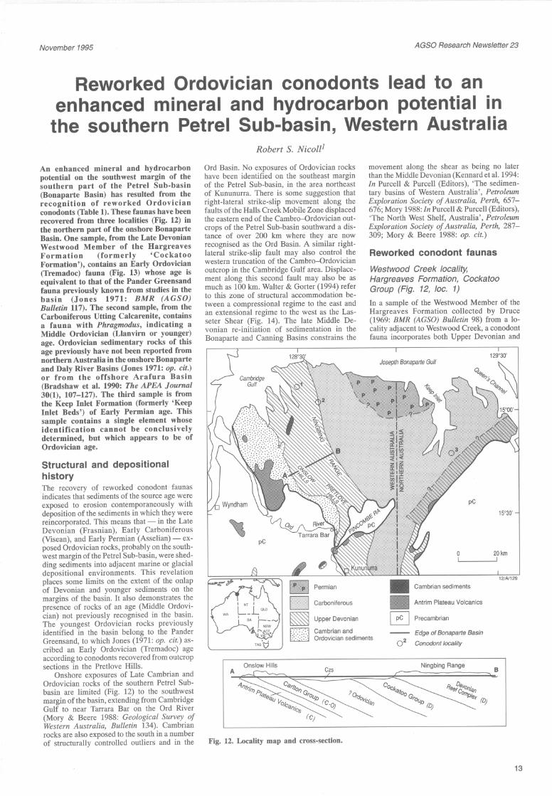
An enhanced mineral and hydrocarbon potential on the southwest margin of the southern part of the Petrel Sub-basin (Bonaparte Basin) has resulted from the recognition of reworked Ordovician conodonts (Table 1). These faunas have been recovered from three localities (Fig. 12) in the northern part of the onshore Bonaparte Basin. One sample, from the Late Devonian Westwood Member of the Hargreaves Formation (formerly 'Cockatoo Formation'), contains an Early Ordovician (Tremadoc) fauna (Fig. 13) whose age is equivalent to that of the Pander Greensand fauna previously known from studies in the basin (Jones 1971: BMR (AGSO) Bulletin 117). The second sample, from the Carboniferous UUing Calcarenite, contains a fauna with Phragmodus, indicating a Middle Ordovician (Llanvirn or younger) age. Ordovician sedimentary rocks of this age previously have not been reported from northern Australia in the onshore Bonaparte and Daly River Basins (Jones 1971: op. cit.) or from the offshore Arafura Basin (Bradshaw et al. 1990: The APEA Journal 30(1), 107-127). The third sample is from the Keep Inlet Formation (formerly 'Keep Inlet Beds') of Early Permian age. This sample contains a single element whose identification cannot be conclusively determined, but which appears to be of Ordovician age.
Structural and depositional history The recovery of reworked conodont faunas indicates that sediments of the source age were exposed to erosion contemporaneously with deposition of the sediments in which they were reincorporated. This means that - in the Late Devonian (Frasnian), Early Carboniferous (Visean), and Early Permian (Asselian) - ex•posed Ordovician rocks, probably on the south•west margin of the Petrel Sub-basin, were shed•ding sediments into adjacent marine or glacial depositional environments. This revelation places some limits on the extent of the onlap of Devonian and younger sediments on the margins of the basin. It also demonstrates the presence of rocks of an age (Middle Ordovi•cian) not previously recognised in the basin. The youngest Ordovician rocks previously identified in the basin belong to the Pander Greensand, to which Jones (1971: op. cit.) as•cribed an Early Ordovician (Tremadoc) age according to conodonts recovered from outcrop sections in the Pretlove Hills.
Onshore exposures of Late Cambrian and Ordovician rocks of the southern Petrel Sub•basin are limited (Fig. 12) to the southwest margin of the basin, extending from Cambridge Gulf to near Tarrara Bar on the Ord River (Mory & Beere 1988: Geological Survey of Western Australia, Bulletin 134). Cambrian rocks are also exposed to the south in a number of structurally controlled outliers and in the
Robert S. Nico1l1
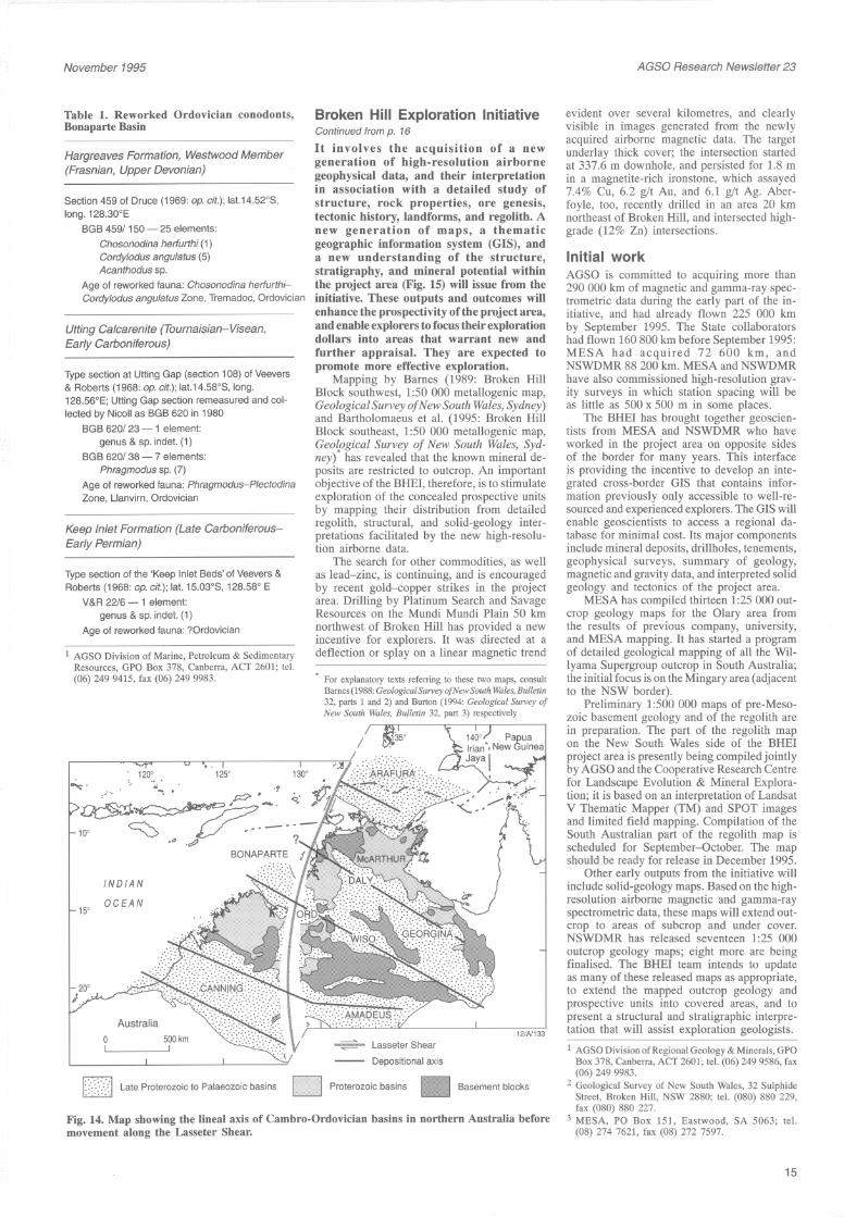
Ord Basin. No exposures of Ordovician rocks have been identified on the southeast margin of the Petrel Sub-basin, in the area northeast of Kununurra. There is some suggestion that right-lateral strike-slip movement along the faults of the Halls Creek Mobile Zone displaced the eastern end of the Cambro-Ordovician out•crops of the Petrel Sub-basin southward a dis•tance of over 200 km where they are now recognised as the Ord Basin. A similar right•lateral strike-slip fault may also control the western truncation of the Cambro-Ordovician outcrop in the Cambridge Gulf area. Displace•ment along this second fault may also be as much as 100 km. Walter & Gorter (1994) refer to this zone of structural accommodation be•tween a compressional regime to the east and an extensional regime to the west as the Las•seter Shear (Fig. 14). The late Middle De•vonian re-initiation of sedimentation in the Bonaparte and Canning Basins constrains the
Carboniferous
movement along the shear as being no later than the Middle Devonian (Kennard et al. 1994: In Purcell & Purcell (Editors), 'The sedimen•tary basins of Western Australia ' , Petroleum Exploration Society of Australia, Perth, 657-676; Mory 1988: In Purcell & Purcell (Editors), 'The North West Shelf, Australia', Petroleum Exploration Society of Australia, Perth, 287-309; Mory & Beere 1988: op. cit.)
Reworked conodont faunas Westwood Creek locality, Hargreaves Formation, Cockatoo Group (Fig. 12, loc. 1) In a sample of the Westwood Member of the Hargreaves Formation collected by Druce (1969: BMR (AGSO) Bulletin 98) from a lo•cality adjacent to Westwood Creek, a conodont fauna incorporates both Upper Devonian and
Josepth Bonaparte Gulf
pC
15' 30'
20km ~ ____ I
121N129
Cambrian sediments
Antrim Plateau Volcanics
Upper Devonian
Cambrian and Ordovician sediments
Precambrian
Edge of Bonaparte Basin
0 2 Conodont locality
Onslow Hills A CZ5
Ningbing Range B
Fig. 12. Locality map and cross-section.
13
November 1995
Table 1. Reworked Ordovician conodonts, Bonaparte Basin
Hargreaves Formation, Westwood Member (Frasnian, Upper Devonian)
Section 459 of Druce (1969: op. cit.); lat.14.52°S, long. 128.300 E
BGB 459/ 150 - 25 elements: Chosonodina herfurthi (1) Cordy/odus angulatus (5) Acanthodus sp.
Age of reworked fauna: Chosonodina herfurthi•Cordylodus angulatus Zone, Tremadoc, Ordovician
Utting Calcarenite (Tournaisian-Visean, Early Carboniferous)
Type section at Utting Gap (section 108) of Veevers & Roberts (1968: op. cit.); lat.14.58°S, long. 128.56°E; Utting Gap section remeasured and col•lected by Nicoll as BGB 620 in 1980
BGB 620/23 - 1 element: genus & sp. indet. (1)
BGB 620/38 - 7 elements: Phragmodus sp. (7)
Age of reworked fauna: Phragmodus-Plectodina Zone, Llanvirn, Ordovician
Keep Inlet Formation (Late Carboniferous•Early Permian)
Type section of the 'Keep Inlet Beds' of Veevers & Roberts (1968: op. cit.); lat. 15.03°S, 128.58° E
V&R 22/6 - 1 element: genus & sp. indet. (1)
Age of reworked fauna: ?Ordovician
1 AGSO Division of Marine, Petroleum & Sedimentary Resources, GPO Box 378, Canberra, ACf 2601; tel. (06) 249 9415, fax (06) 249 9983.
15'
120'
INDIAN
OCEAN
Broken Hill Exploration Initiative Continued from p. 16
It involves the acquisition of a new generation of high-resolution airborne geophysical data, and their interpretation in association with a detailed study of structure, rock properties, ore genesis, tectonic history, landforms, and regolith. A new generation of maps, a thematic geographic information system (GIS), and a new understanding of the structure, stratigraphy, and mineral potential within the project area (Fig. 15) will issue from the initiative. These outputs and outcomes will enhance the prospectivity ofthe project area, and enable explorers to focus their exploration dollars into areas that warrant new and further appraisal. They are expected to promote more effective exploration.
Mapping by Barnes (1989: Broken Hill Block southwest, 1:50 000 metallogenic map, Geological Survey of N ew South Wales, Sydney) and Bartholomaeus et at. (1995: Broken Hill Block southeast, 1:50 000 metallogenic map, Geo{ogical Survey of New South Wales, Syd•ney) has revealed that the known mineral de•posits are restricted to outcrop. An important objective of the BHEI, therefore, is to stimulate exploration of the concealed prospective units by mapping their distribution from detailed regolith, structural, and solid-geology inter•pretations facilitated by the new high-resolu•tion airborne data.
The search for other commodities, as well as lead-zinc, is continuing, and is encouraged by recent gold--copper strikes in the project area. Drilling by Platinum Search and Savage Resources on the Mundi Mundi Plain 50 km northwest of Broken Hill has provided a new incentive for explorers. It was directed at a deflection or splay on a linear magnetic trend
For explanatory texts referring to these two maps, consult Barnes (1988: GeologicalSurveyofNewSouth Wales, Bulletin 32, parts 1 and 2) and Burton (1994: Geological Survey of New South Wales, Bulletin 32, part 3) respectively
121N133
Depositional axis
I~<·\<l Late Proterozoic to Palaeozoic basins D Proterozoic basins lEI Basement blocks
Fig. 14. Map showing the lineal axis of Cambro-Ordovician basins in northern Australia before movement along the Lasseter Shear.
AGSO Research Newsletter 23
evident over several kilometres, and clearly visible in images generated from the newly acquired airborne magnetic data. The target underlay thick cover; the intersection started at 337.6 m downhole, and persisted for 1.8 m in a magnetite-rich ironstone, which assayed 7.4% Cu, 6.2 glt Au, and 6.1 glt Ag. Aber•foyle, too, recently drilled in an area 20 km northeast of Broken Hill, and intersected high•grade (12% Zn) intersections.
Initial work AGSO is committed to acquiring more than 290000 km of magnetic and gamma-ray spec•trometric data during the early part of the in•itiative, and had already flown 225 000 km by September 1995. The State collaborators had flown 160800 km before September 1995: MESA had acquired 72 600 km, and NSWDMR 88 200 km. MESA and NSWDMR have also commissioned high-resolution grav•ity surveys in which station spacing will be as little as 500 x 500 m in some places.
The BHEI has brought together geoscien•tists from MESA and NSWDMR who have worked in the project area on opposite sides of the border for many years. This interface is providing the incentive to develop an inte•grated cross-border GIS that contains infor•mation previously only accessible to well-re•sourced and experienced explorers. The GIS will enable geoscientists to access a regional da•tabase for minimal cost. Its major components include mineral deposits, drillholes, tenements, geophysical surveys, summary of geology, magnetic and gravity data, and interpreted solid geology and tectonics of the project area.
MESA has compiled thirteen 1:25 000 out•crop geology maps for the Olary area from the results of previous company, university, and MESA mapping. It has started a program of detailed geological mapping of all the Wil•Iyama Supergroup outcrop in South Australia; the initial focus is on the Mingary area (adjacent to the NSW border).
Preliminary 1:500 000 maps of pre-Meso•zoic basement geology and of the regolith are in preparation. The part of the regolith map on the New South Wales side of the BHEI project area is presently being compiled jointly by AGSO and the Cooperative Research Centre for Landscape Evolution & Mineral Explora•tion; it is based on an interpretation of Landsat V Thematic Mapper (TM) and SPOT images and limited field mapping. Compilation of the South Australian part of the regolith map is scheduled for September-October. The map should be ready for release in December 1995.
Other early outputs from the initiative will include solid-geology maps. Based on the high•resolution airborne magnetic and gamma-ray spectrometric data, these maps will extend out•crop to areas of sub crop and under cover. NSWDMR has released seventeen 1:25 000 outcrop geology maps; eight more are being finalised. The BHEI team intends to update as many of these released maps as appropriate, to extend the mapped outcrop geology and prospective units into covered areas, and to present a structural and stratigraphic interpre•tation that will assist exploration geologists.
1 AGSO Division of Regional Geology & Minerals, GPO Box 378, Canberra, ACf 2601; tel. (06) 249 9586, fax (06) 249 9983.
2 Geological Survey of New South Wales, 32 Sulphide Street, Broken Hill , NSW 2880; tel. (080) 880 229, fax (080) 880 227.
3 MESA, PO Box 151 , Eastwood, SA 5063 ; tel. (08) 274 7621 , fax (08) 272 7597.
15


![Wonderful Christmas Medley (Reworked)[1]](https://img.pdfslide.net/doc/110x75/577cdf241a28ab9e78b09503/wonderful-christmas-medley-reworked1.jpg)