Embed Size (px)
Citation preview

RG 200 Davidson County
Chancery Court
Plan Index Book 2
Page Title Date Street Names Description
2
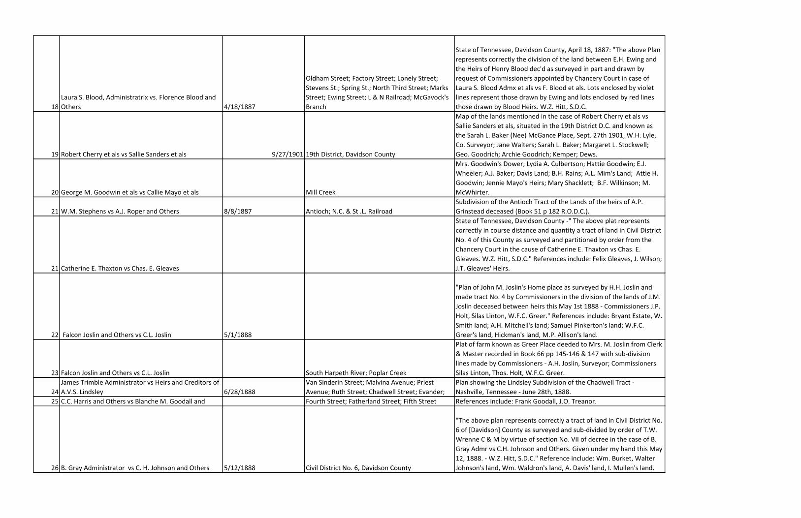
Ed Gannoway Administrator vs F.E. Stewart and
Others (see Report Minute Bk 26 pg 18, April 1887) 12/4/1886; 4/00/1887 Cumberland River; Whites Creek
"This Plan correctly represents the partition of the Estate of M.S.
Stewart dec'd as divided and awarded by drawing lots for distribution
of the shares by the Commissioners appointed by the Chancery Court
of [Davidson] County and is made a part of their Report. W.W.
Southgate, Sur." Incl.: Anna Stewart; N.(?)B. Stewart; Arietta Burnett;
Louisa Price; Lilly Stewart.
3 George A. Reid and Others vs Frank T. Reid and Others 3/00/1887
Malone Avenue, now Olympic or Olympus (?)
Street; Spruce Street or Franklin Pike; Brinkley
Avenue; Reid Avenue
"This Plat represents the Sub-division of the lands of the late John Reid
as surveyed by me this March 1887. W.W. Lyle, Surveyor." "For
corrected plan see page 41." Incl.: Malone Place (now Brennan
School).
4 F.W. Tealey Trustee vs J.H.(?) Buddeke and Others 5/7/1887 Vine Street; Monroe Street Sub-divided by T.W. Wrenne (?) Clerk and Master 5/7/1887
4 G.W. Ankenbauer vs Mary E. Ankenbauer and Others 4/26/1987 Cumberland River
"Description of the land needed for the North Nashville Bridge &
Northern Approach of same now owned by the Ankenbauer Estate.
Beginning at a point in the fence at the lane in the South boundary line
of said estate situated 25 feet in a westerly direction from the Centre
line of the North Nashville Bridge Approach; thence parallel with
Centre line & in a northerly direction 1000 feet; thence square with
said Centre line & in a westerly direction 25 feet; thence parallel with
said Centre line & in a northerly direction 1350 feet; thence square
with said Centre line & in a westerly direction 50 feet; thence parallel
with said Centre line & in a northerly direction 650 feet to a point on
the bank of Cumberland river & in the north boundary line of said
estate; thence square with said Centre line & along the said boundary
line along the bank of Cumberland river & in a easterly direction 225
feet; thence parallel with said Centre line and in a southerly direction
650 feet; thence square with said Centre line & in a westerly direction
75 feet; thence parallel with said Centre line & in a southerly direction
1350 feet; thence square with said Centre line & in a westerly
direction 25 feet; thence parallel with said Centre line & in a southerly
direction 1000 feet to a point in the fence at the lane and in the south
boundary of the estate; thence square with said Centre line & along
the fence at the lane 50 feet to the beginning, containing seven acres
& 60/100 of oan acre of land. E.F. Falconnet, Engineer of North
Nashville Bridge Committee. See Minute Book 25 page 504."
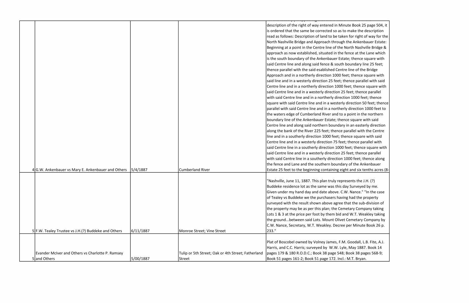
4 G.W. Ankenbauer vs Mary E. Ankenbauer and Others 5/4/1887 Cumberland River
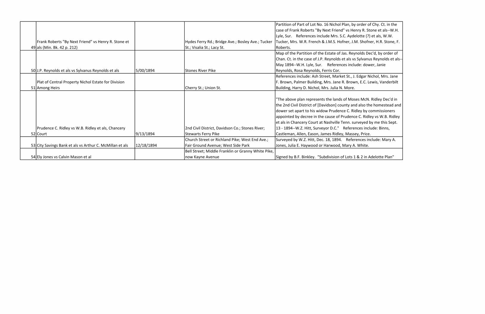
"In this cause (?) it appearing that there was a mistake in the
description of the right of way entered in Minute Book 25 page 504, it
is ordered that the same be corrected so as to make the description
read as follows: Description of land to be taken for right of way for the
North Nashville Bridge and Approach through the Ankenbauer Estate:
Beginning at a point in the Centre line of the North Nashville Bridge &
approach as now established, situated in the fence at the Lane which
is the south boundary of the Ankenbauer Estate; thence square with
said Centre line and along said fence & south boundary line 25 feet;
thence parallel with the said esablished Centre line of the Bridge
Approach and in a northerly direction 1000 feet; thence square with
said line and in a westerly direction 25 feet; thence parallel with said
Centre line and in a northerly direction 1000 feet; thence square with
said Centre line and in a westerly direction 25 feet; thence parallel
with said Centre line and in a northerly direction 1000 feet; thence
square with said Centre line and in a westerly direction 50 feet; thence
parallel with said Centre line and in a northerly direction 1000 feet to
the waters edge of Cumberland River and to a point in the northern
boundary line of the Ankenbauer Estate; thence square with said
Centre line and along said northern boundary in an easterly direction
along the bank of the River 225 feet; thence parallel with the Centre
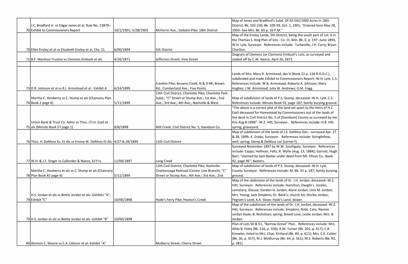
line and in a southerly direction 1000 feet; thence square with said
Centre line and in a westerly direction 75 feet; thence parallel with
said Centre line in a southerly direction 1000 feet; thence square with
said Centre line and in a westerly direction 25 feet; thence parallel
with said Centre line in a southerly direction 1000 feet; thence along
the fence and Lane and the southern boundary of the Ankenbauer
Estate 25 feet to the beginning containing eight and six tenths acres (8-
5 F.W. Tealey Trustee vs J.H.(?) Buddeke and Others 6/11/1887 Monroe Street; Vine Street
"Nashville, June 11, 1887. This plan truly represents the J.H. (?)
Buddeke residence lot as the same was this day Surveyed by me.
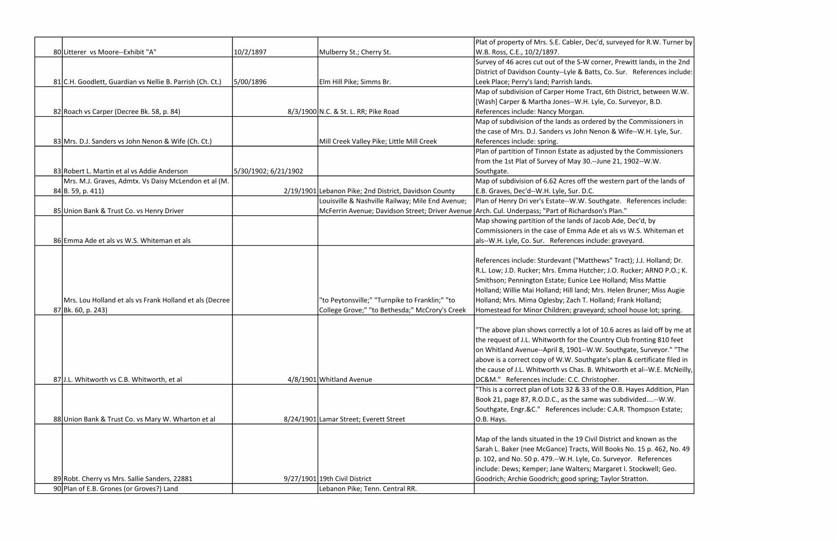
Given under my hand day and date above. C.W. Nance." "In the case
of Tealey vs Buddeke we the purchasers having had the property
surveyed with the result shown above agree that the sub-division of
the property may be as per this plan; the Cemetary Company taking
Lots 1 & 3 at the price per foot by them bid and W.T. Weakley taking
the ground...between said Lots. Mount Olivet Cemetary Company by
C.W. Nance, Secretary, W.T. Weakley. Decree per Minute Book 26 p.
233."
5
Evander McIver and Others vs Charlotte P. Ramsey
and Others 5/00/1887
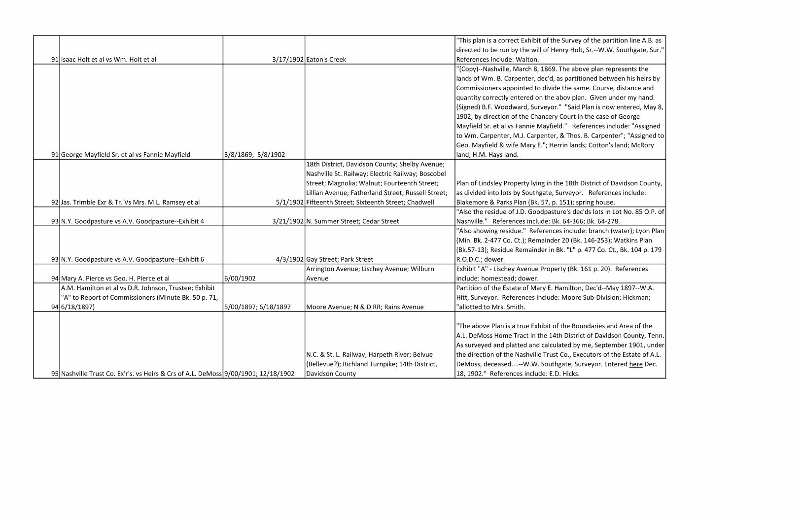
Tulip or 5th Street; Oak or 4th Street; Fatherland
Street
Plat of Boscobel owned by Volney James, F.M. Goodall, L.B. Fite, A.J.
Harris, and C.C. Harris; surveyed by W.W. Lyle, May 1887. Book 14
pages 179 & 180 R.O.D.C.; Book 38 page 548; Book 38 pages 568-9;
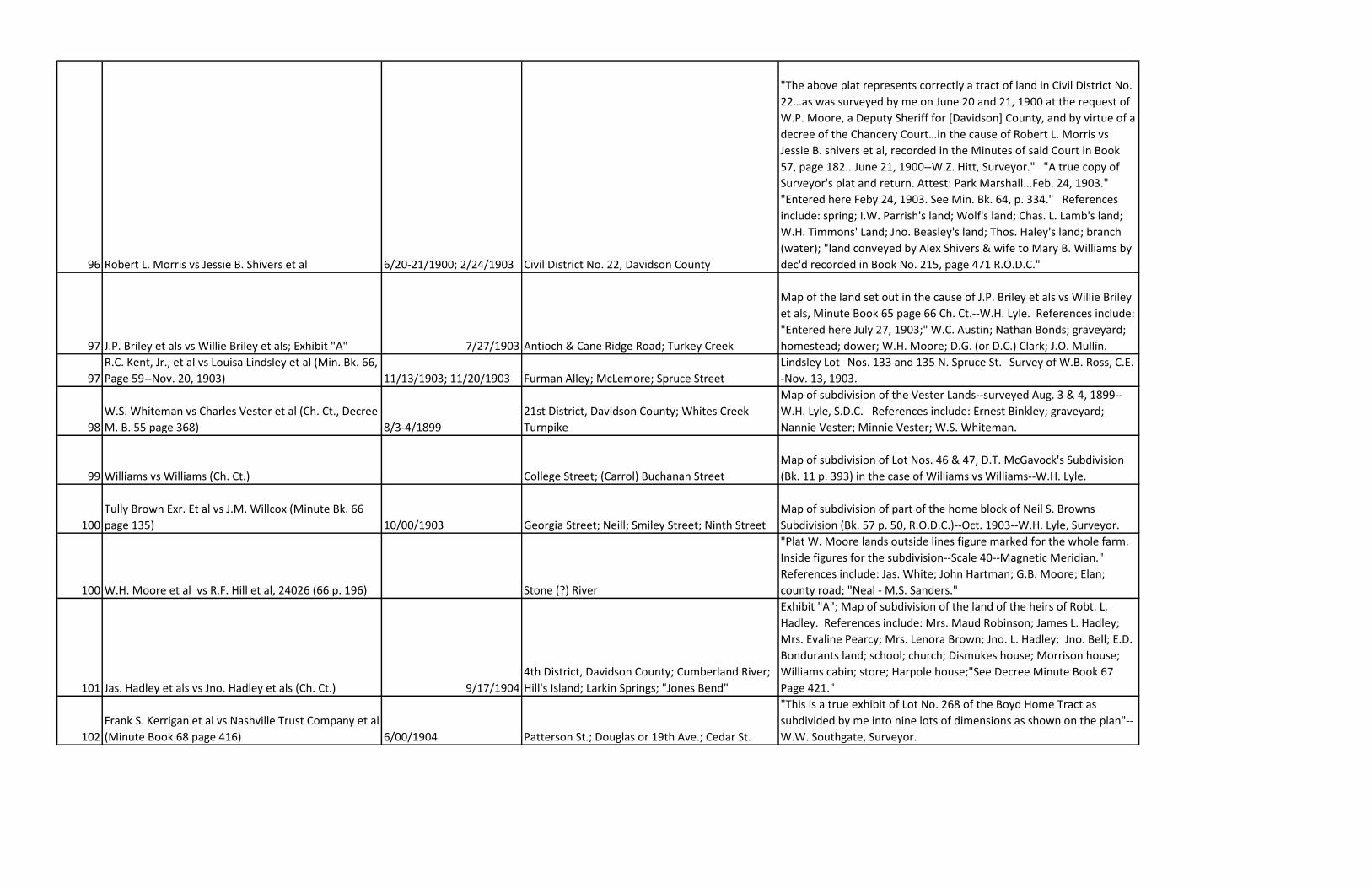
Book 51 pages 161-2; Book 51 page 172. Incl.: M.T. Bryan.

6 Henry W. Stump and Others vs S.W. Steele and Others 5/16/1887 Charlotte Turnpike
Stump Farm West Nashville Tennessee; area 324.3 acres; surveyed by
Waring Chapman Farquhar, Newport, R.I. Includes: Bunting; Davis;
Richards; Demoss; McKissack; Elliston; Charlotte Park Company.
6
Laura W. Plummer and Others vs Clara B. (?) Plummer
and Others Garland Street; Plummer Street; Hillsboro Pike.
Surveyed by W.H. Lyle per decree Min. Book No. 26. Includes:
Vanderbilt grounds; Mrs. Geny land.
7
James Trimble Administrator vs Heirs and Creditors of
A.V. Lindsley dec'd
Division Street; Fatherland Street; Elm Street;
Lindsley Avenue
Includes: Lindsley Homestead; Lindsley's Wood Lot; Spring Park
Property; Chadwell House; Residence Moses Priest.
8
Kittie G. Robertson Guardian vs Sallie Robertson and
Others (see Decree Book 26 page 377) Lebanon Pike; Wilson County's 1st Civil District.
C.H. Robertson's lands, 1st Civil District, Wilson County, Tennessee,
137 acres & 51 poles. Includes: graveyard; Williamson; Cook; Gleaves;
Adams; Harkreader; school lot.
8 William E. Orr vs Ira Orr and Others 7/27/1887 Dickerson Pike; Civil District No. 19.
Davidson County, TN:" The above Plat represents correctly in course,
distance and quantity a tract of land in Civil District No. 19 of the
above named County as surveyed in part by order of M. C. Goodlett,
Solicitor, in the case of William E. Orr vs Ira Orr and Others. Given
under by hand this July 27, 1887. W. Z. Hitt, S.D.C." Decree Minute
Book 26 page 344. Includes: Philips land; Taylor lands; land sold to
Toney; school house lot.
9
Anna Maria Locken and Others vs Anna Maria
Campbell
Watkins Street; Hamilton Street; Clay Street;
Jefferson Street; Polk Street; Jackson Street;
Phillips Street; Harding Street
9 John Jackson and Others vs Robert Duncan and Others Jefferson Street; Salem Street
10 V.K. Stevenson et als vs N.E. Alloway et als
Little Creek; Alabama state line; Shoemake
Branch; Gourd Neck Branch; Holly Flat Branch;
Vaughn Hollow Branch; Mocake Branch; Crosses
Creek; Bee Cliff Branch; No Business Branch; Big
Spring; Young's Creek; Sinkin Cove; Steward
Branch; Custard Hollow Branch; Rush Creek; Crow
Creek; Lost Cove; Ruben Branch; Tally Fork
12998 acres mountain land; 454-3/4 acres farming land; undivided
interest mountain land. J.M. Bass, Grant No. 9585; C.M. Fogg, Grant
No. 9490; F.G. McKay, Grant No. 9488; Anderson & (?) Williams, 4270
acres; L.D. Stevenson, Grant No. 9585; V.K. Stevenson, Grant No.
9492; F.B. Fogg, Grant No. 9489 and Grant No. 9588; A.M. Rutledge,
Grant No. 9493; Sherwood; Tantallon; cave; A. Allison, Grant No. 9487;
B. Littons, Grant No. 9515; G.(?) Marshal, Grant No. 9494; sink hole;
M.W. Brown, Grant No. 9495; P.S. Smith, Grant No. 9587; railroad;
Anderson & Stevenson, 200 A.; Adcoke land; Crabtree; Cowan.
11 V.K. Stevenson et als vs N.W. Alloway et als Frost Point Mountain; Big Spring.
Lot No. 2. Mountain land containing 1952 acres. Includes: Robinson's
land; Crows Nest Farm; J.F.A.; part of Rose & Sharps Entry.
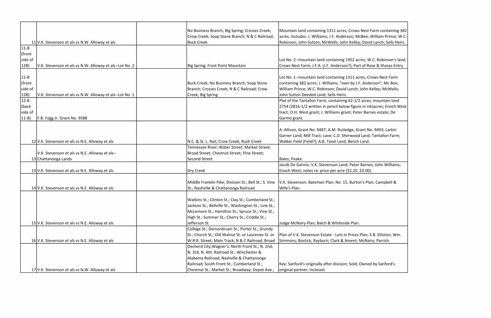
11 V.K. Stevenson et als vs N.W. Alloway et als
No Business Branch; Big Spring; Crosses Creek;
Crow Creek; Soap Stone Branch; N & C Railroad;
Buck Creek
Mountain land containing 1311 acres; Crows Nest Farm containing 382
acres. Includes: J. Williams; J.F. Anderson; McBee; William Prince; W.C.
Robinson; John Sutton; McWells; John Kelley; David Lynch; Sells Heirs.
11-B
(front
side of
12B) V.K. Stevenson et als vs N.W. Alloway et als--Lot No. 2 Big Spring; Frost Point Mountain
Lot No. 2--mountain land containing 1952 acres; W.C. Robinson's land;
Crows Nest Farm; J.F.A. (J.F. Anderson?); Part of Rose & Sharps Entry
11-B
(front
side of
12B) V.K. Stevenson et als vs N.W. Alloway et als--Lot No. 1
Buck Creek; No Business Branch; Soap Stone
Branch; Crosses Creek; N & C Railroad; Crow
Creek; Big Spring
Lot No. 1--mountain land containing 1311 acres, Crows Nest Farm
containing 382 acres; J. Williams, "own by J.F. Anderson"; Mc Bee;
William Prince; W.C. Robinson; David Lynch; John Kelley; McWells;
John Sutton Deeded Land; Sells Heirs.
12-B
(back
side of
11-B) F.B. Fogg Jr. Grant No. 9588
Plat of the Tantallon Farm, containing 62-1/2 acres, mountain land
2754 (2816-1/2 written in pencil below figure in ink)acres; Enoch West
tract; O.H. West grant; J. Williams grant; Peter Barnes estate; De
Garmo grant.
12 V.K. Stevenson et als vs N.E. Alloway et als N.C. & St. L. Rail; Crow Creek; Rush Creek
A. Allison, Grant No. 9487; A.M. Rutledge, Grant No. 9493; Larkin
Garner Land; Mill Tract; cave; C.D. Sherwood Land; Tantallon Farm;
Walker Field (Field?); A.B. Tavel Land; Bench Land.
13
V.K. Stevenson et als vs N.E. Alloway et als--
Chattanooga Lands
Tennessee River; Water Street; Market Street;
Broad Street; Chestnut Street; Pine Street;
Second Street Bales; Peake.
13 V.K. Stevenson et als vs N.E. Alloway et als Dry Creek
Jacob De Garmo; V.K. Stevenson Land; Peter Barnes; John Williams;
Enoch West; notes re: price per acre ($2.25, $3.00).
14 V.K. Stevenson et als vs N.E. Alloway et als
Middle Franklin Pike; Division St.; Bell St.; S. Vine
St.; Nashville & Chattanooga Railroad
V.K. Stevenson; Bateman Plan; No. 15, Burton's Plan; Campbell &
Wife's Plan.
15 V.K. Stevenson et als vs N.E. Alloway et als
Watkins St.; Clinton St.; Clay St.; Cumberland St.;
Jackson St.; Bellville St.; Washington St.; Line St.;
McLemore St.; Hamilton St.; Spruce St.; Vine St.;
High St.; Summer St.; Cherry St.; Criddle St.;
Jefferson St. Judge McNairy Plan; Balch & Whiteside Plan.
16 V.K. Stevenson et als vs N.E. Alloway et als
College St.; Demonbruen St.; Porter St.; Grundy
St.; Church St.; Old Walnut St. or Laurenee St. or
W.R.R. Street; Main Track, N & C Railroad; Broad
Plan of V.K. Stevenson Estate - Lots in Prices Plan; E.B. Elliston; Wm.
Simmons; Bostick; Rayburn; Clark & Ament; McNairy; Parrish.
17 V.K. Stevenson et als vs N.W. Alloway et als
Decherd City;Wagner's; North Front St.; N. 2nd;
N. 3rd; N. 4th; Railroad St.; Winchester &
Alabama Railroad; Nashville & Chattanooga
Railroad; South Front St.; Cumberland St.;
Chestnut St.; Market St.; Broadway; Depot Ave.;
Key: Sanford's originally after division; Sold; Owned by Sanford's
original partner; Inclosed.
18
Laura S. Blood, Administratrix vs. Florence Blood and
Others 4/18/1887
Oldham Street; Factory Street; Lonely Street;
Stevens St.; Spring St.; North Third Street; Marks
Street; Ewing Street; L & N Railroad; McGavock's
Branch
State of Tennessee, Davidson County, April 18, 1887: "The above Plan
represents correctly the division of the land between E.H. Ewing and
the Heirs of Henry Blood dec'd as surveyed in part and drawn by
request of Commissioners appointed by Chancery Court in case of
Laura S. Blood Admx et als vs F. Blood et als. Lots enclosed by violet
lines represent those drawn by Ewing and lots enclosed by red lines
those drawn by Blood Heirs. W.Z. Hitt, S.D.C.
19 Robert Cherry et als vs Sallie Sanders et als 9/27/1901 19th District, Davidson County
Map of the lands mentioned in the case of Robert Cherry et als vs
Sallie Sanders et als, situated in the 19th District D.C. and known as
the Sarah L. Baker (Nee) McGance Place, Sept. 27th 1901, W.H. Lyle,
Co. Surveyor; Jane Walters; Sarah L. Baker; Margaret L. Stockwell;
Geo. Goodrich; Archie Goodrich; Kemper; Dews.
20 George M. Goodwin et als vs Callie Mayo et als Mill Creek
Mrs. Goodwin's Dower; Lydia A. Culbertson; Hattie Goodwin; E.J.
Wheeler; A.J. Baker; Davis Land; B.H. Rains; A.L. Mim's Land; Attie H.
Goodwin; Jennie Mayo's Heirs; Mary Shacklett; B.F. Wilkinson; M.
McWhirter.
21 W.M. Stephens vs A.J. Roper and Others 8/8/1887 Antioch; N.C. & St .L. Railroad
Subdivision of the Antioch Tract of the Lands of the heirs of A.P.
Grinstead deceased (Book 51 p 182 R.O.D.C.).
21 Catherine E. Thaxton vs Chas. E. Gleaves
State of Tennessee, Davidson County -" The above plat represents
correctly in course distance and quantity a tract of land in Civil District
No. 4 of this County as surveyed and partitioned by order from the
Chancery Court in the cause of Catherine E. Thaxton vs Chas. E.
Gleaves. W.Z. Hitt, S.D.C." References include: Felix Gleaves, J. Wilson;
J.T. Gleaves' Heirs.
22 Falcon Joslin and Others vs C.L. Joslin 5/1/1888
"Plan of John M. Joslin's Home place as surveyed by H.H. Joslin and
made tract No. 4 by Commissioners in the division of the lands of J.M.
Joslin deceased between heirs this May 1st 1888 - Commissioners J.P.
Holt, Silas Linton, W.F.C. Greer." References include: Bryant Estate, W.
Smith land; A.H. Mitchell's land; Samuel Pinkerton's land; W.F.C.
Greer's land, Hickman's land, M.P. Allison's land.
23 Falcon Joslin and Others vs C.L. Joslin South Harpeth River; Poplar Creek
Plat of farm known as Greer Place deeded to Mrs. M. Joslin from Clerk
& Master recorded in Book 66 pp 145-146 & 147 with sub-division
lines made by Commissioners - A.H. Joslin, Surveyor; Commissioners
Silas Linton, Thos. Holt, W.F.C. Greer.
24
James Trimble Administrator vs Heirs and Creditors of
A.V.S. Lindsley 6/28/1888
Van Sinderin Street; Malvina Avenue; Priest
Avenue; Ruth Street; Chadwell Street; Evander;
Plan showing the Lindsley Subdivision of the Chadwell Tract -
Nashville, Tennessee - June 28th, 1888.
25 C.C. Harris and Others vs Blanche M. Goodall and Fourth Street; Fatherland Street; Fifth Street References include: Frank Goodall, J.O. Treanor.
26 B. Gray Administrator vs C. H. Johnson and Others 5/12/1888 Civil District No. 6, Davidson County
"The above plan represents correctly a tract of land in Civil District No.
6 of [Davidson] County as surveyed and sub-divided by order of T.W.
Wrenne C & M by virtue of section No. VII of decree in the case of B.
Gray Admr vs C.H. Johnson and Others. Given under my hand this May
12, 1888. - W.Z. Hitt, S.D.C." Reference include: Wm. Burket, Walter
Johnson's land, Wm. Waldron's land, A. Davis' land, I. Mullen's land.
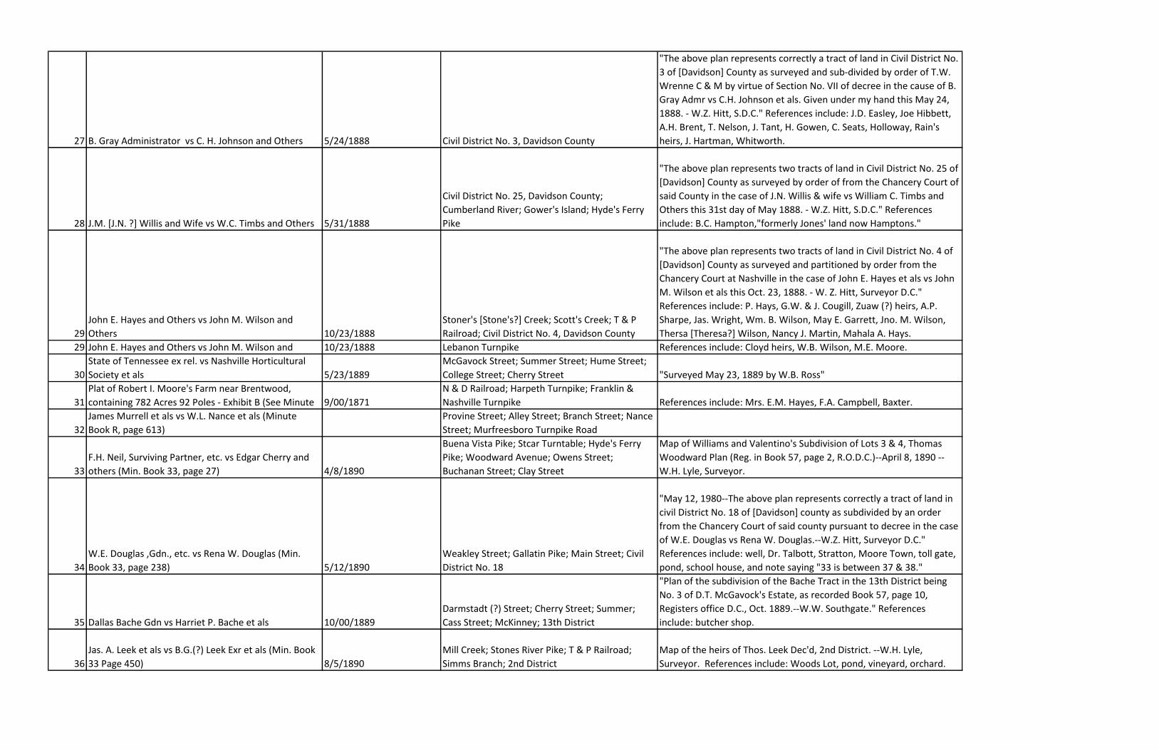
27 B. Gray Administrator vs C. H. Johnson and Others 5/24/1888 Civil District No. 3, Davidson County
"The above plan represents correctly a tract of land in Civil District No.
3 of [Davidson] County as surveyed and sub-divided by order of T.W.
Wrenne C & M by virtue of Section No. VII of decree in the cause of B.
Gray Admr vs C.H. Johnson et als. Given under my hand this May 24,
1888. - W.Z. Hitt, S.D.C." References include: J.D. Easley, Joe Hibbett,
A.H. Brent, T. Nelson, J. Tant, H. Gowen, C. Seats, Holloway, Rain's
heirs, J. Hartman, Whitworth.
28 J.M. [J.N. ?] Willis and Wife vs W.C. Timbs and Others 5/31/1888
Civil District No. 25, Davidson County;
Cumberland River; Gower's Island; Hyde's Ferry
Pike
"The above plan represents two tracts of land in Civil District No. 25 of
[Davidson] County as surveyed by order of from the Chancery Court of
said County in the case of J.N. Willis & wife vs William C. Timbs and
Others this 31st day of May 1888. - W.Z. Hitt, S.D.C." References
include: B.C. Hampton,"formerly Jones' land now Hamptons."
29
John E. Hayes and Others vs John M. Wilson and
Others 10/23/1888
Stoner's [Stone's?] Creek; Scott's Creek; T & P
Railroad; Civil District No. 4, Davidson County
"The above plan represents two tracts of land in Civil District No. 4 of
[Davidson] County as surveyed and partitioned by order from the
Chancery Court at Nashville in the case of John E. Hayes et als vs John
M. Wilson et als this Oct. 23, 1888. - W. Z. Hitt, Surveyor D.C."
References include: P. Hays, G.W. & J. Cougill, Zuaw (?) heirs, A.P.
Sharpe, Jas. Wright, Wm. B. Wilson, May E. Garrett, Jno. M. Wilson,
Thersa [Theresa?] Wilson, Nancy J. Martin, Mahala A. Hays.
29 John E. Hayes and Others vs John M. Wilson and 10/23/1888 Lebanon Turnpike References include: Cloyd heirs, W.B. Wilson, M.E. Moore.
30
State of Tennessee ex rel. vs Nashville Horticultural
Society et als 5/23/1889
McGavock Street; Summer Street; Hume Street;
College Street; Cherry Street "Surveyed May 23, 1889 by W.B. Ross"
31
Plat of Robert I. Moore's Farm near Brentwood,
containing 782 Acres 92 Poles - Exhibit B (See Minute 9/00/1871
N & D Railroad; Harpeth Turnpike; Franklin &
Nashville Turnpike References include: Mrs. E.M. Hayes, F.A. Campbell, Baxter.
32
James Murrell et als vs W.L. Nance et als (Minute
Book R, page 613)
Provine Street; Alley Street; Branch Street; Nance
Street; Murfreesboro Turnpike Road
33
F.H. Neil, Surviving Partner, etc. vs Edgar Cherry and
others (Min. Book 33, page 27) 4/8/1890
Buena Vista Pike; Stcar Turntable; Hyde's Ferry
Pike; Woodward Avenue; Owens Street;
Buchanan Street; Clay Street
Map of Williams and Valentino's Subdivision of Lots 3 & 4, Thomas
Woodward Plan (Reg. in Book 57, page 2, R.O.D.C.)--April 8, 1890 --
W.H. Lyle, Surveyor.
34
W.E. Douglas ,Gdn., etc. vs Rena W. Douglas (Min.
Book 33, page 238) 5/12/1890
Weakley Street; Gallatin Pike; Main Street; Civil
District No. 18
"May 12, 1980--The above plan represents correctly a tract of land in
civil District No. 18 of [Davidson] county as subdivided by an order
from the Chancery Court of said county pursuant to decree in the case
of W.E. Douglas vs Rena W. Douglas.--W.Z. Hitt, Surveyor D.C."
References include: well, Dr. Talbott, Stratton, Moore Town, toll gate,
pond, school house, and note saying "33 is between 37 & 38."
35 Dallas Bache Gdn vs Harriet P. Bache et als 10/00/1889
Darmstadt (?) Street; Cherry Street; Summer;
Cass Street; McKinney; 13th District
"Plan of the subdivision of the Bache Tract in the 13th District being
No. 3 of D.T. McGavock's Estate, as recorded Book 57, page 10,
Registers office D.C., Oct. 1889.--W.W. Southgate." References
include: butcher shop.
36
Jas. A. Leek et als vs B.G.(?) Leek Exr et als (Min. Book
33 Page 450) 8/5/1890
Mill Creek; Stones River Pike; T & P Railroad;
Simms Branch; 2nd District
Map of the heirs of Thos. Leek Dec'd, 2nd District. --W.H. Lyle,
Surveyor. References include: Woods Lot, pond, vineyard, orchard.
37 Mary O'Donnell et als vs J.P. Hickman Admr et als 2/17/1891
Civil District No. 18; McFerrin Avenue; Gallatin
Turnpike
"The above plan represents correctly a tract of land in civil District No.
18 of [Davidson] county as surveyed and subdivided by order from
Chancery Court pursuant to decree in the cause of Mary O'Donnell et
als vs J.P. Hickman Admr et als. This Feb'y 17th 1891.--W.Z. Hitt,
Surveyor D.C." References include: R.S. Anderson Hrs., Mrs. Susie
Thomas, Mrs. Kate Marin, Mrs. Mary Henry, Rosa O'Donnell, Mrs.
Rosa Daniels.
37
Mrs. Letitia Harris vs Robert Harris et als (Min. Bk. K,
page 488); J.W. Gaines Executor vs Mattie Harris et
als 10/23/1890 Nolensville Pike; 9th District
Map of the lands of B.D. Harris, dec'd, 9th Dist., showing Widows
Dower as set out in the case of Mrs. Letitia Harris vs Robert Harris et
als; also the remainder of the land in the case of J.W. Gaines Executor
vs Mattie Harris et als.--Oct. 23rd, 1890, W.W. Lyle, Surveyor.
References include: Book 15, page 203, R.O.D.C.; B.D. Harris to H.
Petway (Book 15, page 585); part of the 100 acre tract purchased of
G.M. Foster (Book 11, page 517).
38 McLean, Hardison & White vs M.A. Patterson et al 6/21/1890 2nd District
Map of the subdivision of the lands of Moses Patterson (Dec'd)
situated in the 2nd District of Davidson County, by order of the
Chancery Court in the case of McLean, Hardison & White vs M.A.
Patterson et al--W.H. Lyle, Surveyor--June 21st, 1890. References
include: A. Buchanan, J.E. Binns, Mrs. P.P. Patterson, L.M. & E.D.
Whitworth, Levicy Goodlet, T.N. Frazier, Joseph Darr.
40
Plan of the T.B. Jones Tract of Land in the 14th District
of Davidson County, Tenn. 12/3-6/1890
14th District; South Harpeth River; East Fork;
Little East Fork
"The above plan represents correctly in course, distance and quantity
a tract of land situated in Civil District No. 14 of [Davidson] county,
known as the T.B. Jones Land, as was surveyed by order of W.H.
Timmons, Admr. This Dec. 3rd-6th, 1890.--W.Z. Hitt, Surveyor D.C."
References include: J.F. Ivey, J.W. Hooper, James Linton, Silas Linton,
Johnson Linton, saw mill.
41
George A. Reid et als vs Frank T. Reid et als--Corrected
Plan 3/00/1887 Spruce Street; Malone Ave.; Reid Ave.
"This Plat represents the subdivision of the late John Reid, as surveyed
by me this March 1887.--W.H. Lyle, Surveyor."
42
Plan of Petway's Subdivision of Lot No. 7 Hobsons
Subd. (Min. Book S, page 363 Circ. Ct.) 4/7/1891
Petway Avenue; McFerrin Avenue; Seymore
Avenue; Gallatin Pike
W.H. Lyle, Surveyor. References include: R.K. Brown, W.J. Gilbert, G.W.
Davis, J.B. Armstrong, Miss Sallie Johnson.
43
Hanner vs Hanner (Book 51, page 440, R.O.D.C.,
Chancery Court) 5/8/1891
Shelby Ave. or Lee St.; Tenth St. or Church St.;
Fatherland St. or Hobson; Eleventh St. or Smith
Ave.
Map of Hanner's Subdivision in the case of Hanner vs Hanner--W.H.
Lyle, Surveyor--May 8th, 1891. References include: electric railway.
44
Jas. A. Leek et al vs Ammon Leek (Min. Bk. 34, p. 170,
Chancery Ct. Cks. O.) 10/8/1891 1st District, Wilson County; Cumberland River
Map of the lands of Thos. Leek Dec'd, 1st District, Wilson County--
surveyed Oct. 8th, 1891, in the case of Jas. A. Leek et al Ammon Leek--
W.H. Lyle, Surveyor.
45
B.F. Binkley vs A.I. Lathan et als, Chancery Court (Min.
Bk. 37, p. 501) Buena Vista Pike
Land of Mrs. A.I. Lathan, in the case of B.F. Binkley vs A.I. Lathan et als--
W.H. Lyle, Surveyor.
45
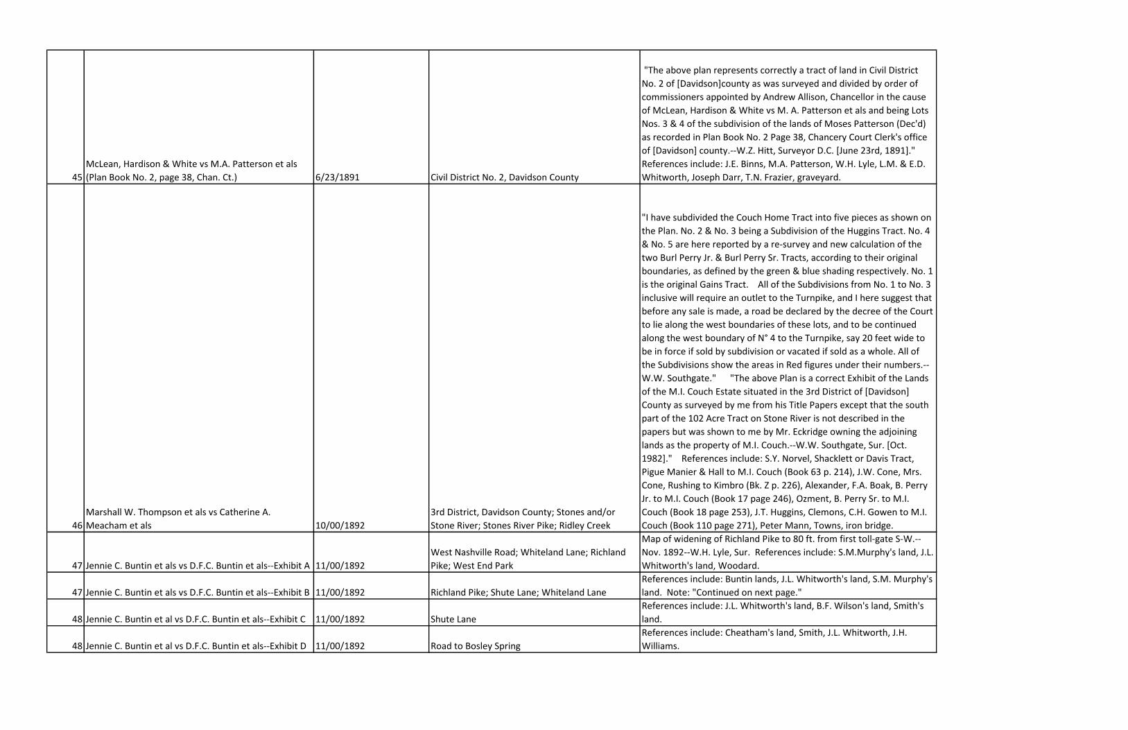
McLean, Hardison & White vs M.A. Patterson et als
(Plan Book No. 2, page 38, Chan. Ct.) 6/23/1891 Civil District No. 2, Davidson County
"The above plan represents correctly a tract of land in Civil District
No. 2 of [Davidson]county as was surveyed and divided by order of
commissioners appointed by Andrew Allison, Chancellor in the cause
of McLean, Hardison & White vs M. A. Patterson et als and being Lots
Nos. 3 & 4 of the subdivision of the lands of Moses Patterson (Dec'd)
as recorded in Plan Book No. 2 Page 38, Chancery Court Clerk's office
of [Davidson] county.--W.Z. Hitt, Surveyor D.C. [June 23rd, 1891]."
References include: J.E. Binns, M.A. Patterson, W.H. Lyle, L.M. & E.D.
Whitworth, Joseph Darr, T.N. Frazier, graveyard.
46
Marshall W. Thompson et als vs Catherine A.
Meacham et als 10/00/1892
3rd District, Davidson County; Stones and/or
Stone River; Stones River Pike; Ridley Creek
"I have subdivided the Couch Home Tract into five pieces as shown on
the Plan. No. 2 & No. 3 being a Subdivision of the Huggins Tract. No. 4
& No. 5 are here reported by a re-survey and new calculation of the
two Burl Perry Jr. & Burl Perry Sr. Tracts, according to their original
boundaries, as defined by the green & blue shading respectively. No. 1
is the original Gains Tract. All of the Subdivisions from No. 1 to No. 3
inclusive will require an outlet to the Turnpike, and I here suggest that
before any sale is made, a road be declared by the decree of the Court
to lie along the west boundaries of these lots, and to be continued
along the west boundary of N° 4 to the Turnpike, say 20 feet wide to
be in force if sold by subdivision or vacated if sold as a whole. All of
the Subdivisions show the areas in Red figures under their numbers.--
W.W. Southgate." "The above Plan is a correct Exhibit of the Lands
of the M.I. Couch Estate situated in the 3rd District of [Davidson]
County as surveyed by me from his Title Papers except that the south
part of the 102 Acre Tract on Stone River is not described in the
papers but was shown to me by Mr. Eckridge owning the adjoining
lands as the property of M.I. Couch.--W.W. Southgate, Sur. [Oct.
1982]." References include: S.Y. Norvel, Shacklett or Davis Tract,
Pigue Manier & Hall to M.I. Couch (Book 63 p. 214), J.W. Cone, Mrs.
Cone, Rushing to Kimbro (Bk. Z p. 226), Alexander, F.A. Boak, B. Perry
Jr. to M.I. Couch (Book 17 page 246), Ozment, B. Perry Sr. to M.I.
Couch (Book 18 page 253), J.T. Huggins, Clemons, C.H. Gowen to M.I.
Couch (Book 110 page 271), Peter Mann, Towns, iron bridge.
47 Jennie C. Buntin et als vs D.F.C. Buntin et als--Exhibit A 11/00/1892
West Nashville Road; Whiteland Lane; Richland
Pike; West End Park
Map of widening of Richland Pike to 80 ft. from first toll-gate S-W.--
Nov. 1892--W.H. Lyle, Sur. References include: S.M.Murphy's land, J.L.
Whitworth's land, Woodard.
47 Jennie C. Buntin et als vs D.F.C. Buntin et als--Exhibit B 11/00/1892 Richland Pike; Shute Lane; Whiteland Lane
References include: Buntin lands, J.L. Whitworth's land, S.M. Murphy's
land. Note: "Continued on next page."
48 Jennie C. Buntin et al vs D.F.C. Buntin et als--Exhibit C 11/00/1892 Shute Lane
References include: J.L. Whitworth's land, B.F. Wilson's land, Smith's
land.
48 Jennie C. Buntin et al vs D.F.C. Buntin et als--Exhibit D 11/00/1892 Road to Bosley Spring
References include: Cheatham's land, Smith, J.L. Whitworth, J.H.
Williams.
49
Frank Roberts "By Next Friend" vs Henry R. Stone et
als (Min. Bk. 42 p. 212)
Hydes Ferry Rd.; Bridge Ave.; Bosley Ave.; Tucker
St.; Visalia St.; Lacy St.
Partition of Part of Lot No. 16 Nichol Plan, by order of Chy. Ct. in the
case of Frank Roberts "By Next Friend" vs Henry R. Stone et als--W.H.
Lyle, Sur. References include Mrs. S.C. Aydelotte (?) et als, W.W.
Tucker, Mrs. W.R. French & J.M.S. Hofner, J.M. Shofner, H.R. Stone, F.
Roberts.
50 J.P. Reynolds et als vs Sylvanus Reynolds et als 5/00/1894 Stones River Pike
Map of the Partition of the Estate of Jas. Reynolds Dec'd, by order of
Chan. Ct. in the case of J.P. Reynolds et als vs Sylvanus Reynolds et als--
May 1894--W.H. Lyle, Sur. References include: dower, Janie
Reynolds, Rosa Reynolds, Ferris Cor.
51
Plat of Central Property Nichol Estate for Division
Among Heirs Cherry St.; Union St.
References include: Ash Street, Market St., J. Edgar Nichol, Mrs. Jane
F. Brown, Palmer Building, Mrs. Jane R. Brown, E.C. Lewis, Vanderbilt
Building, Harry D. Nichol, Mrs. Julia N. More.
52
Prudence C. Ridley vs W.B. Ridley et als, Chancery
Court 9/13/1894
2nd Civil District, Davidson Co.; Stones River;
Stewarts Ferry Pike
"The above plan represents the lands of Moses McN. Ridley Dec'd in
the 2nd Civil District of [Davidson] county and also the homestead and
dower set apart to his widow Prudence C. Ridley by commissioners
appointed by decree in the cause of Prudence C. Ridley vs W.B. Ridley
et als in Chancery Court at Nashville Tenn. surveyed by me this Sept.
13 - 1894--W.Z. Hitt, Surveyor D.C." References include: Binns,
Castleman, Allen, Eason, James Ridley, Massey, Price.
53 City Savings Bank et als vs Arthur C. McMillan et als 12/18/1894
Church Street or Richland Pike; West End Ave.;
Fair Ground Avenue; West Side Park
Surveyed by W.Z. Hitt, Dec. 18, 1894. References include: Mary A.
Jones, Julia E. Haywood or Harwood, Mary A. White.
54 Ely Jones vs Calvin Mason et al
Bell Street; Middle Franklin or Granny White Pike,
now Kayne Avenue Signed by B.F. Binkley. "Subdivision of Lots 1 & 2 in Adelotte Plan"
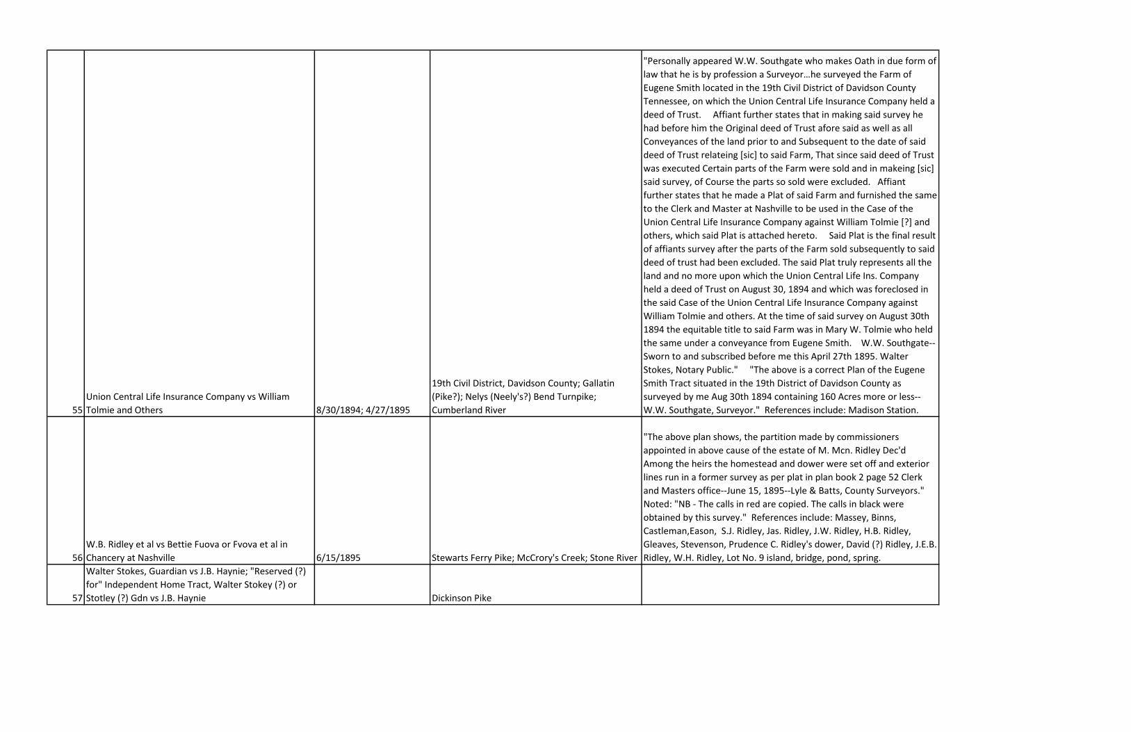
55
Union Central Life Insurance Company vs William
Tolmie and Others 8/30/1894; 4/27/1895
19th Civil District, Davidson County; Gallatin
(Pike?); Nelys (Neely's?) Bend Turnpike;
Cumberland River
"Personally appeared W.W. Southgate who makes Oath in due form of
law that he is by profession a Surveyor…he surveyed the Farm of
Eugene Smith located in the 19th Civil District of Davidson County
Tennessee, on which the Union Central Life Insurance Company held a
deed of Trust. Affiant further states that in making said survey he
had before him the Original deed of Trust afore said as well as all
Conveyances of the land prior to and Subsequent to the date of said
deed of Trust relateing [sic] to said Farm, That since said deed of Trust
was executed Certain parts of the Farm were sold and in makeing [sic]
said survey, of Course the parts so sold were excluded. Affiant
further states that he made a Plat of said Farm and furnished the same
to the Clerk and Master at Nashville to be used in the Case of the
Union Central Life Insurance Company against William Tolmie [?] and
others, which said Plat is attached hereto. Said Plat is the final result
of affiants survey after the parts of the Farm sold subsequently to said
deed of trust had been excluded. The said Plat truly represents all the
land and no more upon which the Union Central Life Ins. Company
held a deed of Trust on August 30, 1894 and which was foreclosed in
the said Case of the Union Central Life Insurance Company against
William Tolmie and others. At the time of said survey on August 30th
1894 the equitable title to said Farm was in Mary W. Tolmie who held
the same under a conveyance from Eugene Smith. W.W. Southgate--
Sworn to and subscribed before me this April 27th 1895. Walter
Stokes, Notary Public." "The above is a correct Plan of the Eugene
Smith Tract situated in the 19th District of Davidson County as
surveyed by me Aug 30th 1894 containing 160 Acres more or less--
W.W. Southgate, Surveyor." References include: Madison Station.
56
W.B. Ridley et al vs Bettie Fuova or Fvova et al in
Chancery at Nashville 6/15/1895 Stewarts Ferry Pike; McCrory's Creek; Stone River
"The above plan shows, the partition made by commissioners
appointed in above cause of the estate of M. Mcn. Ridley Dec'd
Among the heirs the homestead and dower were set off and exterior
lines run in a former survey as per plat in plan book 2 page 52 Clerk
and Masters office--June 15, 1895--Lyle & Batts, County Surveyors."
Noted: "NB - The calls in red are copied. The calls in black were
obtained by this survey." References include: Massey, Binns,
Castleman,Eason, S.J. Ridley, Jas. Ridley, J.W. Ridley, H.B. Ridley,
Gleaves, Stevenson, Prudence C. Ridley's dower, David (?) Ridley, J.E.B.
Ridley, W.H. Ridley, Lot No. 9 island, bridge, pond, spring.
57
Walter Stokes, Guardian vs J.B. Haynie; "Reserved (?)
for" Independent Home Tract, Walter Stokey (?) or
Stotley (?) Gdn vs J.B. Haynie Dickinson Pike
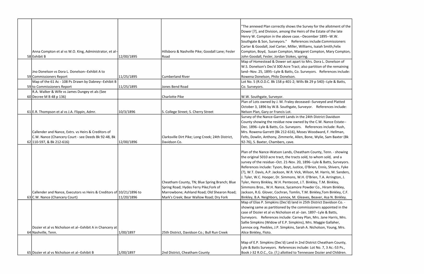
58
Anna Compton et al vs W.O. King, Administrator, et al--
Exhibit B 12/00/1895
Hillsboro & Nashville Pike; Goodall Lane; Fesler
Road
"The annexed Plan correctly shows the Survey for the allotment of the
Dower [?], and Division, among the Heirs of the Estate of the late
Henry W. Compton in the above case.--December 1895--W.W.
Southgate & Son, Surveyors." References include:Commissioners
Carter & Goodall, Joel Carter, Miller, Williams, Isaiah Smith,Felix
Compton, Boyd, Susan Compton, Margaret Compton, Mary Compton,
John Goodall, Fesler, Jordan Stokes, spring.
59
Jno Donelson vs Dora L. Donelson--Exhibit A to
Commissioners Report 11/25/1895 Cumberland River
Map of Homestead & Dower set apart to Mrs. Dora L. Donelson of
W.S. Donelson's Dec'd 300 Acre Tract; also partition of the remaining
land--Nov. 25, 1895--Lyle & Batts, Co. Surveyors. References include:
Rowena Donelson, Philo Donelson.
59
Map of the 61 Ac - 108 Ps Drawn by Dabney--Exhibit B
to Commissioners Report 11/25/1895 Jones Bend Road
Lot No. 5 (R.O.D.C. Bk 158 p 401-2; Wills Bk 29 p 540)--Lyle & Batts,
Co. Surveyors.
60
R.A. Walker & Wife vs James Dungey et als (See
Decree M B 48 p 136) Charlotte Pike W.W. Southgate, Surveyor.
61 E.R. Thompson et al vs J.A. Flippin, Admr. 10/3/1896 S. College Street; S. Cherry Street
Plan of Lots owned by J. M. Fraley deceased--Surveyed and Platted
October 3, 1896 by W.B. Southgate, Surveyor. References include:
Nelson Plan, Gary or Francis Lot.
62
Callender and Nance, Extrs. vs Heirs & Creditors of
C.W. Nance (Chancery Court - see Deeds Bk 92-48, Bk
110-597, & Bk 212-616) 12/00/1896
Clarksville Dirt Pike; Long Creek; 24th District,
Davidson Co.
Survey of the Nance-Garrett Lands in the 24th District Davidson
County showing the residue now owned by the C.W. Nance Estate--
Dec. 1896--Lyle & Batts, Co. Surveyors. References include: Rush,
Mrs. Rowena Garrett (Bk 212-616), Moses Woodward, F. Hellman,
Felts, Dowlin, Anthony, Zimmerle, Allen, Bone, Wylie, Sam Baxter (Bk
92-76), S. Baxter, Chambers, cave.
63
Callender and Nance, Executors vs Heirs & Creditors of
C.W. Nance (Chancery Court)
10/21/1896 to
11/20/1896
Cheatham County, TN; Blue Spring Branch; Blue
Spring Road; Hydes Ferry Pike;Fork of
Marrowbone; Ashland Road; Old Shearon Road;
Mark's Creek; Bear Wallow Road; Dry Fork
Plan of the Nance-Watson Lands, Cheatham County, Tenn. - showing
the original 5010 acre tract, the tracts sold, to whom sold, and a
survey of the residue--Oct. 21-Nov. 20, 1896--Lyle & Batts, Surveyors.
References include: Tyson, Boyt, Justice, O'Brien, Ennis, Shivers, Fyke
(?), W.T. Davis, A.P. Jackson, W.R. Vick, Wilson, M. Harris, M. Sanders,
J. Tyler, W.C. Hooper, Dr. Simmons, W.H. O'Brien, T.A. Arrington, J.
Tyler, Henry Binkley, W.H. Pentecost, J.T. Binkley, T.M. Binkley,
Simmons Bros., W.H. Nance, Sycamore Powder Co., Hiram Binkley,
Jackson, R.G. Glover, Cochran, Tomlin, T.M. Binkley,Tom Binkley, C.F.
Binkley, B.A. Neighbors, Lennox, M. Gleaves, Beaver, Asa N. Binkley.
64
Dozier et al vs Nicholson et al--Exhibit A in Chancery at
Nashville, Tenn. 1/00/1897 25th District, Davidson Co.; Bull Run Creek
Map of Elias P. Simpkins (Dec'd) land in 25th District Davidson Co. -
showing same as partitioned by the commissioners appointed in the
case of Dozier et al vs Nicholson et al--Jan. 1897--Lyle & Batts,
Surveyors. References include: Carney Plan, Mrs. Jane Harris, Mrs.
Sallie Simpkins (Widow of E.P. Simpkins), Mrs. Maggie Gallaher,
Lennox org. Peebles, J.P. Simpkins, Sarah A. Nicholson, Young, Mrs.
Alice Binkley, Floto.
65 Dozier et al vs Nicholson et al--Exhibit B 1/00/1897 2nd District, Cheatham County
Map of E.P. Simpkins (Dec'd) Land in 2nd District Cheatham County,
Lyle & Batts Surveyors. References include: Lot No. 7, 3 Ac.-53 Ps.,
Book J-32 R.O.C., Co. (?,) allotted to Tennessee Dozier and Children.
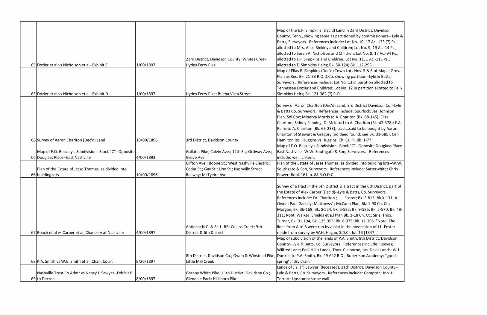
65 Dozier et al vs Nicholson et al--Exhibit C 1/00/1897
23rd District, Davidson County; Whites Creek;
Hydes Ferry Pike
Map of the E.P. Simpkins (Dec'd) Land in 23rd District, Davidson
County, Tenn., showing same as partitioned by commissioners-- Lyle &
Batts, Surveyors. References include: Lot No. 10, 17 Ac.-133 (?) Ps.,
allotted to Mrs. Alice Binkley and Children; Lot No. 9, 19 Ac.-14 Ps.,
allotted to Sarah A. Nicholson and Children; Lot No. 8, 17 Ac.-94 Ps.,
allotted to J.P. Simpkins and Children; Lot No. 11, 1 Ac.-113 Ps.,
allotted to F. Simpkins Heirs; Bk. 50-124; Bk. 112-296.
65 Dozier et al vs Nicholson et al--Exhibit D 1/00/1897 Hydes Ferry Pike; Buena Vista Street
Map of Elias P. Simpkins (Dec'd) Town Lots Nos. 5 & 6 of Maple Grove
Plan as Rec. Bk. 21-83 R.O.D.Co. showing partition--Lyle & Batts,
Surveyors. References include: Lot No. 13 in partition allotted to
Tennessee Dozier and Children; Lot No. 12 in partition allotted to Felix
Simpkins Heirs; Bk. 121-382 (?) R.O.
66 Survey of Aaron Charlton (Dec'd) Land 10/00/1896 3rd District, Davidson County
Survey of Aaron Charlton (Dec'd) Land, 3rd District Davidson Co.--Lyle
& Batts Co. Surveyors. References include: Spurlock; Jas. Johnson
Plan, Sol Cox; Minerva Morris to A. Charlton (Bk. 68-145); Eliza
Charlton; Sidney Fanning; D. McInturf to A. Charlton (Bk. 42-378); F.A.
Rains to A. Charlton (Bk. 66-233); tract...said to be bought by Aaron
Charlton of Stewart & Gregory (no deed found; see Bk. 31-585); Cen
Hamilton Ro.; Huggins vs Huggins, Ch. Ct. Pl. Bk. 1-77.
66
Map of F.O. Beazley's Subdivision--Block "C"--Opposite
Douglass Place--East Nashville 4/00/1893
Gallatin Pike; Calvin Ave.; 12th St.; Ordway Ave.;
Grove Ave.
Map of F.O. Beazley's Subdivision--Block "C"--Opposite Douglass Place--
East Nashville--W.W. Southgate & Son, Surveyors. References
include: well, cistern.
66
Plan of the Estate of Jesse Thomas, as divided into
building lots 10/00/1896
Clifton Ave.; Boone St.; West Nashville Electric;
Cedar St.; Gay St.; Line St.; Nashville Street
Railway; McTyeire Ave.
Plan of the Estate of Jesse Thomas, as divided into building lots--W.W.
Southgate & Son, Surveyors. References include: Satterwhite; Chris
Power; Book 161, p. 88 R.O.D.C.
67 Roach et al vs Carper et al, Chancery at Nashville 4/00/1897
Antioch; N.C. & St. L. RR; Collins Creek; 5th
District & 6th District
Survey of a tract in the 5th District & a tract in the 6th District, part of
the Estate of Alex Carper (Dec'd)--Lyle & Batts, Co. Surveyors.
References include: Dr. Charlton ;J.L. Foster; Bk. S-813; Bk X-131; A.J.
Owen; Paul Gadsey; Matthews' ; McCann Plan, Bk. 1-90 Ch. Ct.;
Morgan, Bk. 36-169; Bk. S-524; Bk. S-523; Bk. 9-586; Bk. 5-570; Bk. 48-
311; Robt. Walker; Shields et a,l Plan Bk. 1-18 Ch. Ct.; Sirls; Thos.
Turner, Bk. 91-194, Bk. 125-355; Bk. 8-375; Bk. 11-195. "Note: The
lines from A to B were run by a plat in the possession of J.L. Foster
made from survey by W.H. Hagan, S.D.C., Jul. 13 [1847]."
68 P.A. Smith vs W.E. Smith et al, Chan. Court 8/26/1897
8th District, Davidson Co.; Owen & Winstead Pike;
Little Mill Creek
Map of subdivision of the lands of P.A. Smith, 8th District, Davidson
County--Lyle & Batts, Co. Surveyors. References include: Reeves;
Wilfred Lane; Polk Hill's Lands; Thos. Claiborne; Jas. Davis Lands; W.J.
Dunklin to P.A. Smith, Bk. 49-642 R.O.; Robertson Academy; "good
spring", "dry drain."
69
Nashville Trust Co Admr vs Nancy J. Sawyer--Exhibit B
to Decree 8/00/1897
Granny White Pike; 11th District, Davidson Co.;
Glendale Park; Hillsboro Pike
Lands of J.Y. (?) Sawyer (deceased), 11th District, Davidson County--
Lyle & Batts, Co. Surveyors. References include: Compton; Jno. H.
Terrett; Lipscomb; stone wall.
70
J.C. Bradford Jr. vs Edgar Jones et al, Rule No. 23879--
Exhibit to Commissioners Report 10/1/1901; 5/28/1903 McFerrin Ave.; Gallatin Pike; 18th District
Map of Jones and Bradford's Subd. Of 43-542/1000 Acres in 18th
District, Bk. 102-230, Bk. 109-39, Oct. 1, 1901; "Entered here May 28,
1903--See Min. Bk. 65 p. 16 P.M."
70 Ellen Ensley et al vs Elizabeth Ensley et al, Chy. Ct. 6/00/1894 5th District
Map of the Ensley Lands, 5th District, being the south part of Lot 6 in
the Thomas S. King Plan of lots - Co. Ct. Min. Bk. E, p. 197--June 1894,
W.H. Lyle, Surveyor. References include: Turbeville; J.H. Curry; Bryan
Charlton.
71 B.F. Manlove Trustee vs Clemons Embush et als 4/26/1871 Jefferson Street; Vine Street
Diagram of Clemens (or Clemons) Embush's Lots, as surveyed and
staked off by C.W. Nance, April 26, 1871.
73 D.R. Johnson et al vs R.I. Armistead et al - Exhibit A 6/24/1899
Franklin Pike; Browns Creek; N & D RR; Brown
Rd.; Cumberland Ave.; Five Points
Lands of Mrs. Mary R. Armistead, dec'd (Book 22 p. 124 R.O.D.C.),
subdivided and made Exhibit to Commissioners Report--W.H. Lyle, C.S.
References include: W.B. Armistead; Roberta A. Johnson; Mary
Hughes; J.W. Armistead; Julia W. Andrews; G.M. Fogg.
74
Martha C. Hooberry vs C. Stump et als (Chancery Plan
Book 2 page 6) 5/11/1899
13th Civil District; Charlotte Pike; Charlotte Park
Subd.; "C" Street or Stump Ave.; 1st Ave.; 2nd
Ave.; 3rd Ave.; 4th Ave.; Nashville & West
Map of subdivision of lands of P.S. Stump, deceased--W.H. Lyle, C.S.
References include: Minute Book 55, page 187; family burying ground.
75
Union Bank & Trust Co. Admr vs Thos. (?) H. Ezell et
als (Minute Book 57 page 1) 8/8/1898 Mill Creek; Civil District No. 5, Davidson Co.
"The above is a correct plot of the land set apart to the Heirs of H.C.
Ezell deceased for Homestead by Commissioners out of the lands of
the decd in Civil District No. 5 of [Davidson] County as surveyed by me
this Aug 8-1898"--W.Z. Hitt, Surveyor. References include: H.B. Hill;
spring; graveyard.
76 Thos. H. DeMoss Ex. Et Als vs Emma W. DeMoss Et Als 4/27 & 28/1899 12th Civil District
Map of subdivision of the lands of J.S. DeMoss Dec.--surveyed Apr. 27
& 28, 1899--E. Drake, Surveyor. References include: Stringfellow;
well; spring; Demp & DeMoss cor [corner?].
77 W.H. & J.F. Singer vs Callender & Nance, Ex't'rs. 11/00/1897 Long Creek
Surveyed November 1897 by W.W. Southgate, Surveyor. References
include: Capps; Hellman; Felts; R. Wylie (Aug. 23, 1884); Garrett; Hugh
Barr; "claimed by Sam Baxter under deed from Mt. Olivet Co., Book
92, page 96"; Baxters.
78
Martha C. Hooberry et als vs C. Stump et als (Chancery
Plan Book #2 page 6) 5/11/1899
13th Civil District; Charlotte Pike; Nashville-
Chattanooga Railroad (Center Line Branch); "C"
Street or Stump Ave.; 4th Ave.; 3rd Ave.; 2nd
Map of subdivision of lands of P.S. Stump, deceased--W.H. Lyle,
County Surveyor. References include: M. Bk. 55 p. 187; family burying
ground.
79
H.S. Jordan et als vs Bettie Jordan et als--Exhibits "A",
Exhibit "C" 10/00/1898 Hyde's Ferry Pike; Heaton's Creek
Map of the ubdivision of the lands of Dr. J.H. Jordan, deceased--W.Z.
Hitt, Surveyor. References include: Hamilton; Dwight L. Jordan;
cemetary; Glouse; Gordon H. Jordan; Alyne Jordan; Unis M. Jordan;
Mrs. Young; Jack Simpkins; Dr. Bank's; church lot; Shirley Jordan;
Pegram's Land; A.A. Sloan; Hyde's Land; dower.
79 H.S. Jordan et als vs Bettie Jordan et als--Exhibit "B" 10/00/1898
Map of the subdivision of the lands of Dr. J.H. Jordan, deceased--W.Z.
Hitt, Surveyor. References include: Simpkins; Robt. Cato; Nannie
Jordan Hyde; B. Nicholson; spring; Breed Love; Leslie Jordan; Mrs. B.
Jordan.
80 Ammon C. Moore vs C.A. Litterer et al--Exhibit "A" Mulberry Street; Cherry Street
Plan of Lots 50 & 51, "Barrow Grove" Plan. References include: Mrs.
Alida B. Foley (Bk. 216, p. 550); R.W. Turner (Bk. 201, p. 417); C.B.
Knowles, listed to Mrs. Chas. Kirtland (Bk. 89, p. 611); Mrs. C.E. Cabler
(Bk. 36, p. 357); W.J. McMurray (Bk. 64, p. 561); M.S. Roberts (Bk. 92,
p. 381).
80 Litterer vs Moore--Exhibit "A" 10/2/1897 Mulberry St.; Cherry St.
Plat of property of Mrs. S.E. Cabler, Dec'd, surveyed for R.W. Turner by
W.B. Ross, C.E., 10/2/1897.
81 C.H. Goodlett, Guardian vs Nellie B. Parrish (Ch. Ct.) 5/00/1896 Elm Hill Pike; Simms Br.
Survey of 46 acres cut out of the S-W corner, Prewitt lands, in the 2nd
District of Davidson County--Lyle & Batts, Co. Sur. References include:
Leek Place; Perry's land; Parrish lands.
82 Roach vs Carper (Decree Bk. 58, p. 84) 8/3/1900 N.C. & St. L. RR; Pike Road
Map of subdivision of Carper Home Tract, 6th District, between W.W.
[Wash] Carper & Martha Jones--W.H. Lyle, Co. Surveyor, B.D.
References include: Nancy Morgan.
83 Mrs. D.J. Sanders vs John Nenon & Wife (Ch. Ct.) Mill Creek Valley Pike; Little Mill Creek
Map of subdivision of the lands as ordered by the Commissioners in
the case of Mrs. D.J. Sanders vs John Nenon & Wife--W.H. Lyle, Sur.
References include: spring.
83 Robert L. Martin et al vs Addie Anderson 5/30/1902; 6/21/1902
Plan of partition of Tinnon Estate as adjusted by the Commissioners
from the 1st Plat of Survey of May 30.--June 21, 1902--W.W.
Southgate.
84
Mrs. M.J. Graves, Admtx. Vs Daisy McLendon et al (M.
B. 59, p. 411) 2/19/1901 Lebanon Pike; 2nd District, Davidson County
Map of subdivision of 6.62 Acres off the western part of the lands of
E.B. Graves, Dec'd--W.H. Lyle, Sur. D.C.
85 Union Bank & Trust Co. vs Henry Driver
Louisville & Nashville Railway; Mile End Avenue;
McFerrin Avenue; Davidson Street; Driver Avenue
Plan of Henry Dri ver's Estate--W.W. Southgate. References include:
Arch. Cul. Underpass; "Part of Richardson's Plan."
86 Emma Ade et als vs W.S. Whiteman et als
Map showing partition of the lands of Jacob Ade, Dec'd, by
Commissioners in the case of Emma Ade et als vs W.S. Whiteman et
als--W.H. Lyle, Co. Sur. References include: graveyard.
87
Mrs. Lou Holland et als vs Frank Holland et als (Decree
Bk. 60, p. 243)
"to Peytonsville;" "Turnpike to Franklin;" "to
College Grove;" "to Bethesda;" McCrory's Creek
References include: Sturdevant ("Matthews" Tract); J.J. Holland; Dr.
R.L. Low; J.D. Rucker; Mrs. Emma Hutcher; J.O. Rucker; ARNO P.O.; K.
Smithson; Pennington Estate; Eunice Lee Holland; Miss Mattie
Holland; Willie Mai Holland; Hill land; Mrs. Helen Bruner; Miss Augie
Holland; Mrs. Mima Oglesby; Zach T. Holland; Frank Holland;
Homestead for Minor Children; graveyard; school house lot; spring.
87 J.L. Whitworth vs C.B. Whitworth, et al 4/8/1901 Whitland Avenue
"The above plan shows correctly a lot of 10.6 acres as laid off by me at
the request of J.L. Whitworth for the Country Club fronting 810 feet
on Whitland Avenue--April 8, 1901--W.W. Southgate, Surveyor." "The
above is a correct copy of W.W. Southgate's plan & certificate filed in
the cause of J.L. Whitworth vs Chas. B. Whitworth et al--W.E. McNeilly,
DC&M." References include: C.C. Christopher.
88 Union Bank & Trust Co. vs Mary W. Wharton et al 8/24/1901 Lamar Street; Everett Street
"This is a correct plan of Lots 32 & 33 of the O.B. Hayes Addition, Plan
Book 21, page 87, R.O.D.C., as the same was subdivided....--W.W.
Southgate, Engr.&C." References include: C.A.R. Thompson Estate;
O.B. Hays.
89 Robt. Cherry vs Mrs. Sallie Sanders, 22881 9/27/1901 19th Civil District
Map of the lands situated in the 19 Civil District and known as the
Sarah L. Baker (nee McGance) Tracts, Will Books No. 15 p. 462, No. 49
p. 102, and No. 50 p. 479.--W.H. Lyle, Co. Surveyor. References
include: Dews; Kemper; Jane Walters; Margaret I. Stockwell; Geo.
Goodrich; Archie Goodrich; good spring; Taylor Stratton.
90 Plan of E.B. Grones (or Groves?) Land Lebanon Pike; Tenn. Central RR.
91 Isaac Holt et al vs Wm. Holt et al 3/17/1902 Eaton's Creek
"This plan is a correct Exhibit of the Survey of the partition line A.B. as
directed to be run by the will of Henry Holt, Sr.--W.W. Southgate, Sur."
References include: Walton.
91 George Mayfield Sr. et al vs Fannie Mayfield 3/8/1869; 5/8/1902
"(Copy)--Nashville, March 8, 1869. The above plan represents the
lands of Wm. B. Carpenter, dec'd, as partitioned between his heirs by
Commissioners appointed to divide the same. Course, distance and
quantity correctly entered on the abov plan. Given under my hand.
(Signed) B.F. Woodward, Surveyor." "Said Plan is now entered, May 8,
1902, by direction of the Chancery Court in the case of George
Mayfield Sr. et al vs Fannie Mayfield." References include: "Assigned
to Wm. Carpenter, M.J. Carpenter, & Thos. B. Carpenter"; "Assigned to
Geo. Mayfield & wife Mary E."; Herrin lands; Cotton's land; McRory
land; H.M. Hays land.
92 Jas. Trimble Exr & Tr. Vs Mrs. M.L. Ramsey et al 5/1/1902
18th District, Davidson County; Shelby Avenue;
Nashville St. Railway; Electric Railway; Boscobel
Street; Magnolia; Walnut; Fourteenth Street;
Lillian Avenue; Fatherland Street; Russell Street;
Fifteenth Street; Sixteenth Street; Chadwell
Plan of Lindsley Property lying in the 18th District of Davidson County,
as divided into lots by Southgate, Surveyor. References include:
Blakemore & Parks Plan (Bk. 57, p. 151); spring house.
93 N.Y. Goodpasture vs A.V. Goodpasture--Exhibit 4 3/21/1902 N. Summer Street; Cedar Street
"Also the residue of J.D. Goodpasture's dec'ds lots in Lot No. 85 O.P. of
Nashville." References include: Bk. 64-366; Bk. 64-278.
93 N.Y. Goodpasture vs A.V. Goodpasture--Exhibit 6 4/3/1902 Gay Street; Park Street
"Also showing residue." References include: branch (water); Lyon Plan
(Min. Bk. 2-477 Co. Ct.); Remainder 20 (Bk. 146-253); Watkins Plan
(Bk.57-13); Residue Remainder in Bk. "L" p. 477 Co. Ct., Bk. 104 p. 179
R.O.D.C.; dower.
94 Mary A. Pierce vs Geo. H. Pierce et al 6/00/1902
Arrington Avenue; Lischey Avenue; Wilburn
Avenue
Exhibit "A" - Lischey Avenue Property (Bk. 161 p. 20). References
include: homestead; dower.
94
A.M. Hamilton et al vs D.R. Johnson, Trustee; Exhibit
"A" to Report of Commissioners (Minute Bk. 50 p. 71,
6/18/1897) 5/00/1897; 6/18/1897 Moore Avenue; N & D RR; Rains Avenue
Partition of the Estate of Mary E. Hamilton, Dec'd--May 1897--W.A.
Hitt, Surveyor. References include: Moore Sub-Division; Hickman;
"allotted to Mrs. Smith.
95 Nashville Trust Co. Ex'r's. vs Heirs & Crs of A.L. DeMoss 9/00/1901; 12/18/1902
N.C. & St. L. Railway; Harpeth River; Belvue
(Bellevue?); Richland Turnpike; 14th District,
Davidson County
"The above Plan is a true Exhibit of the Boundaries and Area of the
A.L. DeMoss Home Tract in the 14th District of Davidson County, Tenn.
As surveyed and platted and calculated by me, September 1901, under
the direction of the Nashville Trust Co., Executors of the Estate of A.L.
DeMoss, deceased....--W.W. Southgate, Surveyor. Entered here Dec.
18, 1902." References include: E.D. Hicks.
96 Robert L. Morris vs Jessie B. Shivers et al 6/20-21/1900; 2/24/1903 Civil District No. 22, Davidson County
"The above plat represents correctly a tract of land in Civil District No.
22…as was surveyed by me on June 20 and 21, 1900 at the request of
W.P. Moore, a Deputy Sheriff for [Davidson] County, and by virtue of a
decree of the Chancery Court…in the cause of Robert L. Morris vs
Jessie B. shivers et al, recorded in the Minutes of said Court in Book
57, page 182...June 21, 1900--W.Z. Hitt, Surveyor." "A true copy of
Surveyor's plat and return. Attest: Park Marshall...Feb. 24, 1903."
"Entered here Feby 24, 1903. See Min. Bk. 64, p. 334." References
include: spring; I.W. Parrish's land; Wolf's land; Chas. L. Lamb's land;
W.H. Timmons' Land; Jno. Beasley's land; Thos. Haley's land; branch
(water); "land conveyed by Alex Shivers & wife to Mary B. Williams by
dec'd recorded in Book No. 215, page 471 R.O.D.C."
97 J.P. Briley et als vs Willie Briley et als; Exhibit "A" 7/27/1903 Antioch & Cane Ridge Road; Turkey Creek
Map of the land set out in the cause of J.P. Briley et als vs Willie Briley
et als, Minute Book 65 page 66 Ch. Ct.--W.H. Lyle. References include:
"Entered here July 27, 1903;" W.C. Austin; Nathan Bonds; graveyard;
homestead; dower; W.H. Moore; D.G. (or D.C.) Clark; J.O. Mullin.
97
R.C. Kent, Jr., et al vs Louisa Lindsley et al (Min. Bk. 66,
Page 59--Nov. 20, 1903) 11/13/1903; 11/20/1903 Furman Alley; McLemore; Spruce Street
Lindsley Lot--Nos. 133 and 135 N. Spruce St.--Survey of W.B. Ross, C.E.-
-Nov. 13, 1903.
98
W.S. Whiteman vs Charles Vester et al (Ch. Ct., Decree
M. B. 55 page 368) 8/3-4/1899
21st District, Davidson County; Whites Creek
Turnpike
Map of subdivision of the Vester Lands--surveyed Aug. 3 & 4, 1899--
W.H. Lyle, S.D.C. References include: Ernest Binkley; graveyard;
Nannie Vester; Minnie Vester; W.S. Whiteman.
99 Williams vs Williams (Ch. Ct.) College Street; (Carrol) Buchanan Street
Map of subdivision of Lot Nos. 46 & 47, D.T. McGavock's Subdivision
(Bk. 11 p. 393) in the case of Williams vs Williams--W.H. Lyle.
100
Tully Brown Exr. Et al vs J.M. Willcox (Minute Bk. 66
page 135) 10/00/1903 Georgia Street; Neill; Smiley Street; Ninth Street
Map of subdivision of part of the home block of Neil S. Browns
Subdivision (Bk. 57 p. 50, R.O.D.C.)--Oct. 1903--W.H. Lyle, Surveyor.
100 W.H. Moore et al vs R.F. Hill et al, 24026 (66 p. 196) Stone (?) River
"Plat W. Moore lands outside lines figure marked for the whole farm.
Inside figures for the subdivision--Scale 40--Magnetic Meridian."
References include: Jas. White; John Hartman; G.B. Moore; Elan;
county road; "Neal - M.S. Sanders."
101 Jas. Hadley et als vs Jno. Hadley et als (Ch. Ct.) 9/17/1904
4th District, Davidson County; Cumberland River;
Hill's Island; Larkin Springs; "Jones Bend"
Exhibit "A"; Map of subdivision of the land of the heirs of Robt. L.
Hadley. References include: Mrs. Maud Robinson; James L. Hadley;
Mrs. Evaline Pearcy; Mrs. Lenora Brown; Jno. L. Hadley; Jno. Bell; E.D.
Bondurants land; school; church; Dismukes house; Morrison house;
Williams cabin; store; Harpole house;"See Decree Minute Book 67
Page 421."
102
Frank S. Kerrigan et al vs Nashville Trust Company et al
(Minute Book 68 page 416) 6/00/1904 Patterson St.; Douglas or 19th Ave.; Cedar St.
"This is a true exhibit of Lot No. 268 of the Boyd Home Tract as
subdivided by me into nine lots of dimensions as shown on the plan"--
W.W. Southgate, Surveyor.
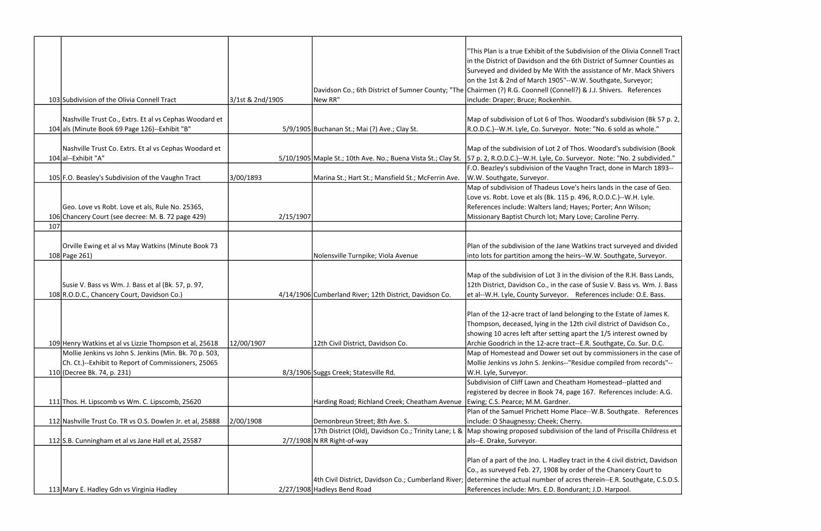
103 Subdivision of the Olivia Connell Tract 3/1st & 2nd/1905
Davidson Co.; 6th District of Sumner County; "The
New RR"
"This Plan is a true Exhibit of the Subdivision of the Olivia Connell Tract
in the District of Davidson and the 6th District of Sumner Counties as
Surveyed and divided by Me With the assistance of Mr. Mack Shivers
on the 1st & 2nd of March 1905"--W.W. Southgate, Surveyor;
Chairmen (?) R.G. Coonnell (Connell?) & J.J. Shivers. References
include: Draper; Bruce; Rockenhin.
104
Nashville Trust Co., Extrs. Et al vs Cephas Woodard et
als (Minute Book 69 Page 126)--Exhibit "B" 5/9/1905 Buchanan St.; Mai (?) Ave.; Clay St.
Map of subdivision of Lot 6 of Thos. Woodard's subdivision (Bk 57 p. 2,
R.O.D.C.)--W.H. Lyle, Co. Surveyor. Note: "No. 6 sold as whole."
104
Nashville Trust Co. Extrs. Et al vs Cephas Woodard et
al--Exhibit "A" 5/10/1905 Maple St.; 10th Ave. No.; Buena Vista St.; Clay St.
Map of the subdivision of Lot 2 of Thos. Woodard's subdivision (Book
57 p. 2, R.O.D.C.)--W.H. Lyle, Co. Surveyor. Note: "No. 2 subdivided."
105 F.O. Beasley's Subdivision of the Vaughn Tract 3/00/1893 Marina St.; Hart St.; Mansfield St.; McFerrin Ave.
F.O. Beazley's subdivision of the Vaughn Tract, done in March 1893--
W.W. Southgate, Surveyor.
106
Geo. Love vs Robt. Love et als, Rule No. 25365,
Chancery Court (see decree: M. B. 72 page 429) 2/15/1907
Map of subdivision of Thadeus Love's heirs lands in the case of Geo.
Love vs. Robt. Love et als (Bk. 115 p. 496, R.O.D.C.)--W.H. Lyle.
References include: Walters land; Hayes; Porter; Ann Wilson;
Missionary Baptist Church lot; Mary Love; Caroline Perry.
107
108
Orville Ewing et al vs May Watkins (Minute Book 73
Page 261) Nolensville Turnpike; Viola Avenue
Plan of the subdivision of the Jane Watkins tract surveyed and divided
into lots for partition among the heirs--W.W. Southgate, Surveyor.
108
Susie V. Bass vs Wm. J. Bass et al (Bk. 57, p. 97,
R.O.D.C., Chancery Court, Davidson Co.) 4/14/1906 Cumberland River; 12th District, Davidson Co.
Map of the subdivision of Lot 3 in the division of the R.H. Bass Lands,
12th District, Davidson Co., in the case of Susie V. Bass vs. Wm. J. Bass
et al--W.H. Lyle, County Surveyor. References include: O.E. Bass.
109 Henry Watkins et al vs Lizzie Thompson et al, 25618 12/00/1907 12th Civil District, Davidson Co.
Plan of the 12-acre tract of land belonging to the Estate of James K.
Thompson, deceased, lying in the 12th civil district of Davidson Co.,
showing 10 acres left after setting apart the 1/5 interest owned by
Archie Goodrich in the 12-acre tract--E.R. Southgate, Co. Sur. D.C.
110
Mollie Jenkins vs John S. Jenkins (Min. Bk. 70 p. 503,
Ch. Ct.)--Exhibit to Report of Commissioners, 25065
(Decree Bk. 74, p. 231) 8/3/1906 Suggs Creek; Statesville Rd.
Map of Homestead and Dower set out by commissioners in the case of
Mollie Jenkins vs John S. Jenkins--"Residue compiled from records"--
W.H. Lyle, Surveyor.
111 Thos. H. Lipscomb vs Wm. C. Lipscomb, 25620 Harding Road; Richland Creek; Cheatham Avenue
Subdivision of Cliff Lawn and Cheatham Homestead--platted and
registered by decree in Book 74, page 167. References include: A.G.
Ewing; C.S. Pearce; M.M. Gardner.
112 Nashville Trust Co. TR vs O.S. Dowlen Jr. et al, 25888 2/00/1908 Demonbreun Street; 8th Ave. S.
Plan of the Samuel Prichett Home Place--W.B. Southgate. References
include: O Shaugnessy; Cheek; Cherry.
112 S.B. Cunningham et al vs Jane Hall et al, 25587 2/7/1908
17th District (Old), Davidson Co.; Trinity Lane; L &
N RR Right-of-way
Map showing proposed subdivision of the land of Priscilla Childress et
als--E. Drake, Surveyor.
113 Mary E. Hadley Gdn vs Virginia Hadley 2/27/1908
4th Civil District, Davidson Co.; Cumberland River;
Hadleys Bend Road
Plan of a part of the Jno. L. Hadley tract in the 4 civil district, Davidson
Co., as surveyed Feb. 27, 1908 by order of the Chancery Court to
determine the actual number of acres therein--E.R. Southgate, C.S.D.S.
References include: Mrs. E.D. Bondurant; J.D. Harpool.

114
G.B. Whitworth et al vs Joseph Warner et al, 26174
(Minute Book 75 page 475) 10/6/1908
Harding Turnpike; Tennessee Central Railroad;
Whitland Avenue.
Plat of a tract of land containing 14 acres being a part of the lands
owned by J.L. Whitworth heirs--W.B. Southgate, Surveyor.
References include: Edwin Warner; Golf Club lease.
114
G.B. Whitworth et al vs Edwin Warner et al (Minute
Book 75 page 493) 10/19/1908 Tennessee Central Railway; 7th District
Plat of a tract containing 7-64/100 Ac. being a part of J.L. Whitworth
Estate in the 7th District--W.B. Southgate, Surveyor. References
include: Golf Club lease.
115
116
Mrs. Saidee Polk Fall Gardner vs Nashville Trust Co.
(Minute Book 77 page 13) Harding Pike
Map of Lynnwood, property of M.M. Gardner Estate, showing that
portion which was set aside as part of dower to Mrs. Saidee Polk Fall
Gardner, widow of M.M. Gardner "Dec'd"; filed as Exhibit to Report of
Commissioners--E.R. Southgate, Davidson County Surveyor.
117
L.H. Geny Admr. vs L.M. Klein et al, 25818 (Decree
Book 77 page 124)
Garland Avenue; Highland Avenue; Hillsboro Pike
or 21st Avenue; Dixie Avenue
Plan of Yost and McGugins subdivision of Geny property. References
include: McMurray & Allen - Del; University Heights; the Thompson
Estate.
118
119
Eugenia Cozad vs Eugene Fitch & Wife Mary D. Fitch
(Chancery Court) 7/30/1909 Gallatin Turnpike
Map showing survey of the land to be conveyed by Eugene Fitch to
Charles H. Fitch in accordance with items No. 1 & 2 in agreement in
the case of Eugenia Cozad vs Eugene & Mary D. Fitch--Erle Drake,
Surveyor. References include: Lanier Land; Eugenia Cozad to W.T.
Anderson (Bk 347 p. 287 R.O.D.C.); B.F. Bicksler.
120
121
Subdivision of the O.A. Simpkins Farm (Plan Bk. 161 o,
117 R.O.D.C.) 10/12/1909
13th District, Davidson County; Scottsboro
Station on T.C. Rwy; Private Road R.F.D. No. 6;
Sulphur Creek; Bull Run Creek; Bull Run Station on
Map showing subdivision of the O.A. Simpkins Farm--Erle Drake,
Surveyor. References include: L.R. Campbell (Decree M.B. 77 pages
219 & 313; spring; cemetary; Rucker's land; James Young.
122
Julia A. Joiner vs D.C. Love et als (Min. Bk. "W" p. 61,
Ch. Ct.) Nolensville Pike; Whittsitt Road; Joiner Avenue
Map of subdivision of Julia A. Joiner's lot as selected by her in case of
Julia A. Joiner vs D.C. Love et als, CORRECTED Map (M.B. 78 page 101)--
W.H. Lyle, Surveyor. References include: church & school lot;
Cumberland Nursery Subd.; Henry McCord.
122
Julia A. Joiner vs D.C. Love et als (Min. Bk. "W" p. 61,
Ch. Ct.) 7/23/1909 Nolensville Pike; Whitset Road; Joiner Avenue
Map of subdivision of Julia A. Joiner's lot as selected by her in the case
of Julia A. Joiner vs D.C. Love et als--W.H. Lyle. References include:
Wm. Gordon vs Howell Brandon (Ch. Ct. Min. Bk. 71 or 77, p. 53);
Woodbine M.W.S. Church; St. Rwy Right-of-way; Baptist church;
Cumberland Nursery Subd.; school lot; church lot; Geo. Patton.
123
124
W.F. Davis & Wife vs Annie A. Jenkins et al--Exhibit "A"
to Report of [Commissioners?] 6/28/1910 Grand Avenue
Plat of W.F. Davis property surveyed June 28, 1910--W.B. Southgate.
References include: Mrs. M.B. Johns Lot.
124
Plan of a subdivision of Lots 8 & 9 of the W.L.B.
Lawrence Plan 2/00/1910 Sweetbriar Avenue; Kayne Avenue
Plan of a subdivision of Lots 8 & 9 of the W.L.B. Lawrence Plan
surveyed and subdivided by W.B. Southgate. References include:
Belmont Land Co. Plan.
Back of
page
Plan of a 50-acre tract of the lands owned by the
Whitworth Estate--Exhibit "B" for 26769, filed 12/00/1909; 1/19/1910 Tennessee Central Railway; West End Avenue
Plan of a 50-acre tract being a part of the lands owned by the
Whitworth Estate, surveyed December 1909 by W.B. Southgate.
125-A
CONTINUED from back of page 124: Plan of a 50-acre
tract of the lands owned by the Whitworth Estate--
Exhibit "B" for 26769, filed 1/19/1910 12/00/1909; 1/19/1910 West End Avenue; West Nashville Road
Plan of a 50-acre tract being a part of the lands owned by the
Whitworth Estate, surveyed December 1909 by W.B. Southgate.
References include: Bransford's Subdivision; Edwards.
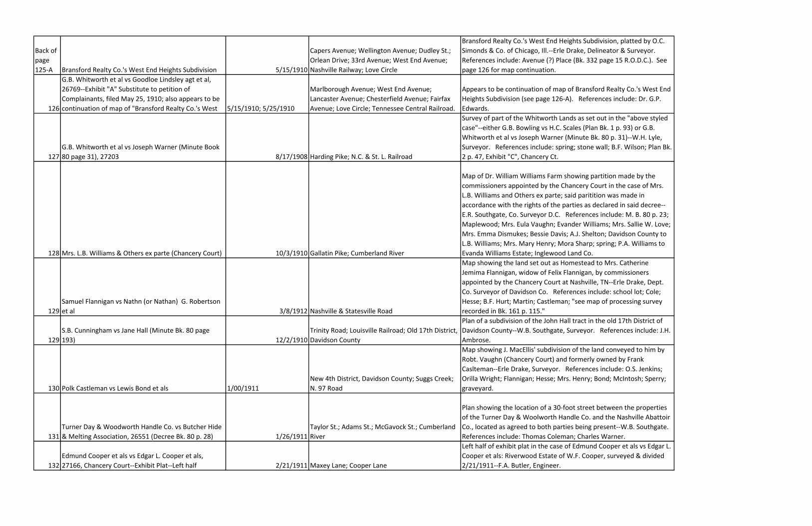
Back of
page
125-A Bransford Realty Co.'s West End Heights Subdivision 5/15/1910
Capers Avenue; Wellington Avenue; Dudley St.;
Orlean Drive; 33rd Avenue; West End Avenue;
Nashville Railway; Love Circle
Bransford Realty Co.'s West End Heights Subdivision, platted by O.C.
Simonds & Co. of Chicago, Ill.--Erle Drake, Delineator & Surveyor.
References include: Avenue (?) Place (Bk. 332 page 15 R.O.D.C.). See
page 126 for map continuation.
126
G.B. Whitworth et al vs Goodloe Lindsley agt et al,
26769--Exhibit "A" Substitute to petition of
Complainants, filed May 25, 1910; also appears to be
continuation of map of "Bransford Realty Co.'s West 5/15/1910; 5/25/1910
Marlborough Avenue; West End Avenue;
Lancaster Avenue; Chesterfield Avenue; Fairfax
Avenue; Love Circle; Tennessee Central Railroad.
Appears to be continuation of map of Bransford Realty Co.'s West End
Heights Subdivision (see page 126-A). References include: Dr. G.P.
Edwards.
127
G.B. Whitworth et al vs Joseph Warner (Minute Book
80 page 31), 27203 8/17/1908 Harding Pike; N.C. & St. L. Railroad
Survey of part of the Whitworth Lands as set out in the "above styled
case"--either G.B. Bowling vs H.C. Scales (Plan Bk. 1 p. 93) or G.B.
Whitworth et al vs Joseph Warner (Minute Bk. 80 p. 31)--W.H. Lyle,
Surveyor. References include: spring; stone wall; B.F. Wilson; Plan Bk.
2 p. 47, Exhibit "C", Chancery Ct.
128 Mrs. L.B. Williams & Others ex parte (Chancery Court) 10/3/1910 Gallatin Pike; Cumberland River
Map of Dr. William Williams Farm showing partition made by the
commissioners appointed by the Chancery Court in the case of Mrs.
L.B. Williams and Others ex parte; said paritition was made in
accordance with the rights of the parties as declared in said decree--
E.R. Southgate, Co. Surveyor D.C. References include: M. B. 80 p. 23;
Maplewood; Mrs. Eula Vaughn; Evander Williams; Mrs. Sallie W. Love;
Mrs. Emma Dismukes; Bessie Davis; A.J. Shelton; Davidson County to
L.B. Williams; Mrs. Mary Henry; Mora Sharp; spring; P.A. Williams to
Evanda Williams Estate; Inglewood Land Co.
129
Samuel Flannigan vs Nathn (or Nathan) G. Robertson
et al 3/8/1912 Nashville & Statesville Road
Map showing the land set out as Homestead to Mrs. Catherine
Jemima Flannigan, widow of Felix Flannigan, by commissioners
appointed by the Chancery Court at Nashville, TN--Erle Drake, Dept.
Co. Surveyor of Davidson Co. References include: school lot; Cole;
Hesse; B.F. Hurt; Martin; Castleman; "see map of processing survey
recorded in Bk. 161 p. 115."
129
S.B. Cunningham vs Jane Hall (Minute Bk. 80 page
193) 12/2/1910
Trinity Road; Louisville Railroad; Old 17th District,
Davidson County
Plan of a subdivision of the John Hall tract in the old 17th District of
Davidson County--W.B. Southgate, Surveyor. References include: J.H.
Ambrose.
130 Polk Castleman vs Lewis Bond et als 1/00/1911
New 4th District, Davidson County; Suggs Creek;
N. 97 Road
Map showing J. MacEllis' subdivision of the land conveyed to him by
Robt. Vaughn (Chancery Court) and formerly owned by Frank
Caslteman--Erle Drake, Surveyor. References include: O.S. Jenkins;
Orilla Wright; Flannigan; Hesse; Mrs. Henry; Bond; McIntosh; Sperry;
graveyard.
131
Turner Day & Woodworth Handle Co. vs Butcher Hide
& Melting Association, 26551 (Decree Bk. 80 p. 28) 1/26/1911
Taylor St.; Adams St.; McGavock St.; Cumberland
River
Plan showing the location of a 30-foot street between the properties
of the Turner Day & Woolworth Handle Co. and the Nashville Abattoir
Co., located as agreed to both parties being present--W.B. Southgate.
References include: Thomas Coleman; Charles Warner.
132
Edmund Cooper et als vs Edgar L. Cooper et als,
27166, Chancery Court--Exhibit Plat--Left half 2/21/1911 Maxey Lane; Cooper Lane
Left half of exhibit plat in the case of Edmund Cooper et als vs Edgar L.
Cooper et als: Riverwood Estate of W.F. Cooper, surveyed & divided
2/21/1911--F.A. Butler, Engineer.
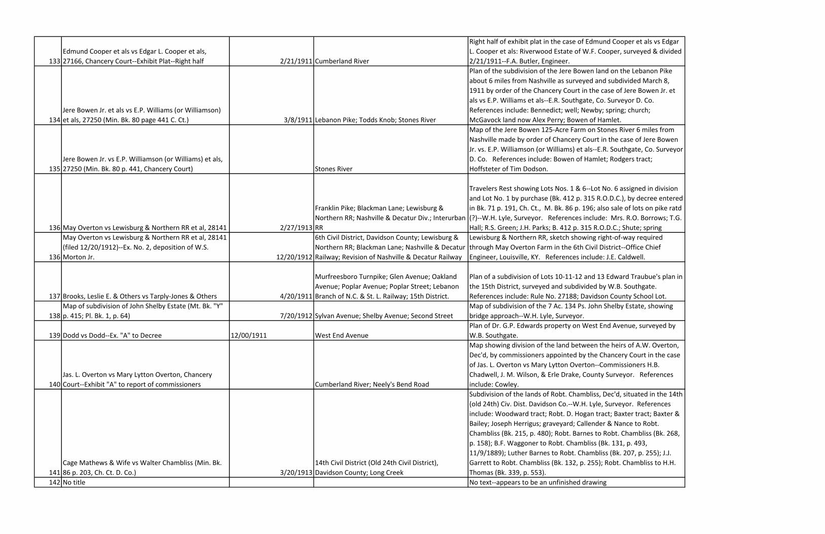
133
Edmund Cooper et als vs Edgar L. Cooper et als,
27166, Chancery Court--Exhibit Plat--Right half 2/21/1911 Cumberland River
Right half of exhibit plat in the case of Edmund Cooper et als vs Edgar
L. Cooper et als: Riverwood Estate of W.F. Cooper, surveyed & divided
2/21/1911--F.A. Butler, Engineer.
134
Jere Bowen Jr. et als vs E.P. Williams (or Williamson)
et als, 27250 (Min. Bk. 80 page 441 C. Ct.) 3/8/1911 Lebanon Pike; Todds Knob; Stones River
Plan of the subdivision of the Jere Bowen land on the Lebanon Pike
about 6 miles from Nashville as surveyed and subdivided March 8,
1911 by order of the Chancery Court in the case of Jere Bowen Jr. et
als vs E.P. Williams et als--E.R. Southgate, Co. Surveyor D. Co.
References include: Bennedict; well; Newby; spring; church;
McGavock land now Alex Perry; Bowen of Hamlet.
135
Jere Bowen Jr. vs E.P. Williamson (or Williams) et als,
27250 (Min. Bk. 80 p. 441, Chancery Court) Stones River
Map of the Jere Bowen 125-Acre Farm on Stones River 6 miles from
Nashville made by order of Chancery Court in the case of Jere Bowen
Jr. vs. E.P. Williamson (or Williams) et als--E.R. Southgate, Co. Surveyor
D. Co. References include: Bowen of Hamlet; Rodgers tract;
Hoffsteter of Tim Dodson.
136 May Overton vs Lewisburg & Northern RR et al, 28141 2/27/1913
Franklin Pike; Blackman Lane; Lewisburg &
Northern RR; Nashville & Decatur Div.; Interurban
RR
Travelers Rest showing Lots Nos. 1 & 6--Lot No. 6 assigned in division
and Lot No. 1 by purchase (Bk. 412 p. 315 R.O.D.C.), by decree entered
in Bk. 71 p. 191, Ch. Ct., M. Bk. 86 p. 196; also sale of lots on pike ratd
(?)--W.H. Lyle, Surveyor. References include: Mrs. R.O. Borrows; T.G.
Hall; R.S. Green; J.H. Parks; B. 412 p. 315 R.O.D.C.; Shute; spring
136
May Overton vs Lewisburg & Northern RR et al, 28141
(filed 12/20/1912)--Ex. No. 2, deposition of W.S.
Morton Jr. 12/20/1912
6th Civil District, Davidson County; Lewisburg &
Northern RR; Blackman Lane; Nashville & Decatur
Railway; Revision of Nashville & Decatur Railway
Lewisburg & Northern RR, sketch showing right-of-way required
through May Overton Farm in the 6th Civil District--Office Chief
Engineer, Louisville, KY. References include: J.E. Caldwell.
137 Brooks, Leslie E. & Others vs Tarply-Jones & Others 4/20/1911
Murfreesboro Turnpike; Glen Avenue; Oakland
Avenue; Poplar Avenue; Poplar Street; Lebanon
Branch of N.C. & St. L. Railway; 15th District.
Plan of a subdivision of Lots 10-11-12 and 13 Edward Traubue's plan in
the 15th District, surveyed and subdivided by W.B. Southgate.
References include: Rule No. 27188; Davidson County School Lot.
138
Map of subdivision of John Shelby Estate (Mt. Bk. "Y"
p. 415; Pl. Bk. 1, p. 64) 7/20/1912 Sylvan Avenue; Shelby Avenue; Second Street
Map of subdivision of the 7 Ac. 134 Ps. John Shelby Estate, showing
bridge approach--W.H. Lyle, Surveyor.
139 Dodd vs Dodd--Ex. "A" to Decree 12/00/1911 West End Avenue
Plan of Dr. G.P. Edwards property on West End Avenue, surveyed by
W.B. Southgate.
140
Jas. L. Overton vs Mary Lytton Overton, Chancery
Court--Exhibit "A" to report of commissioners Cumberland River; Neely's Bend Road
Map showing division of the land between the heirs of A.W. Overton,
Dec'd, by commissioners appointed by the Chancery Court in the case
of Jas. L. Overton vs Mary Lytton Overton--Commissioners H.B.
Chadwell, J. M. Wilson, & Erle Drake, County Surveyor. References
include: Cowley.
141
Cage Mathews & Wife vs Walter Chambliss (Min. Bk.
86 p. 203, Ch. Ct. D. Co.) 3/20/1913
14th Civil District (Old 24th Civil District),
Davidson County; Long Creek
Subdivision of the lands of Robt. Chambliss, Dec'd, situated in the 14th
(old 24th) Civ. Dist. Davidson Co.--W.H. Lyle, Surveyor. References
include: Woodward tract; Robt. D. Hogan tract; Baxter tract; Baxter &
Bailey; Joseph Herrigus; graveyard; Callender & Nance to Robt.
Chambliss (Bk. 215, p. 480); Robt. Barnes to Robt. Chambliss (Bk. 268,
p. 158); B.F. Waggoner to Robt. Chambliss (Bk. 131, p. 493,
11/9/1889); Luther Barnes to Robt. Chambliss (Bk. 207, p. 255); J.J.
Garrett to Robt. Chambliss (Bk. 132, p. 255); Robt. Chambliss to H.H.
Thomas (Bk. 339, p. 553).
142 No title No text--appears to be an unfinished drawing
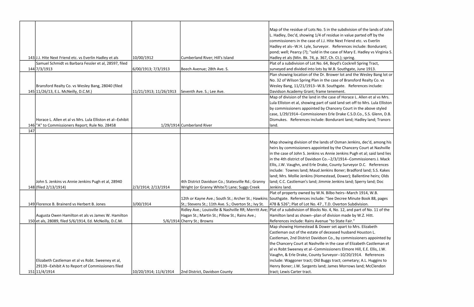
143 J.J. Hite Next Friend etc. vs Everlin Hadley et als 10/00/1912 Cumberland River; Hill's Island
Map of the residue of Lots No. 5 in the subdivision of the lands of John
L. Hadley, Dec'd, showing 1/4 of residue in value parted off by the
commissioners in the case of J.J. Hite Next Friend etc. vs Everlin
Hadley et als--W.H. Lyle, Surveyor. References include: Bondurant;
pond; well; Pearcy (?); "sold in the case of Mary E. Hadley vs Virginia S.
Hadley et als (Min. Bk. 74, p. 367, Ch. Ct.); spring.
144
Samuel Schmidt vs Barbara Fessler et al, 28597, filed
7/3/1913 6/00/1913; 7/3/1913 Beech Avenue; 28th Ave. S.
Plat of a subdivision of Lot No. 64, Boyd's Cockrell Spring Tract,
surveyed and divided into lots by W.B. Southgate, June 1913.
145
Bransford Realty Co. vs Wesley Bang, 28040 (filed
11/26/13, E.L. McNeilly, D.C.M.) 11/21/1913; 11/26/1913 Seventh Ave. S.; Lee Ave.
Plan showing location of the Dr. Brower lot and the Wesley Bang lot or
No. 32 of Wilson Spring Plan in the case of Bransford Realty Co. vs
Wesley Bang, 11/21/1913--W.B. Southgate. References include:
Davidson Academy Grant; frame tenement.
146
Horace L. Allen et al vs Mrs. Lula Elliston et al--Exhibit
"A" to Commissioners Report; Rule No. 28458 1/29/1914 Cumberland River
Map of division of the land in the case of Horace L. Allen et al vs Mrs.
Lula Elliston et al, showing part of said land set off to Mrs. Lula Elliston
by commissioners appointed by Chancery Court in the above styled
case, 1/29/1914--Commissioners Erle Drake C.S.D.Co., S.S. Glenn, D.B.
Dismukes. References include: Bondurant land; Hadley land; Tranors
land.
147
148
John S. Jenkins vs Annie Jenkins Pugh et al, 28940
(filed 2/13/1914) 2/3/1914; 2/13/1914
4th District Davidson Co.; Statesville Rd.; Granny
Wright (or Granny White?) Lane; Suggs Creek
Map showing division of the lands of Osman Jenkins, dec'd, among his
heirs by commissioners appointed by the Chancery Court at Nashville
in the case of John S. Jenkins vs Annie Jenkins Pugh et al; said land lies
in the 4th district of Davidson Co.--2/3/1914--Commissioners J. Mack
Ellis, J.W. Vaughn, and Erle Drake, County Surveyor D.C. References
include: Townes land; Maud Jenkins Boner; Bradford land; S.S. Kakes
land; Mrs. Mollie Jenkins (Homestead, Dower); Ballentine heirs; Olds
land; C.C. Castleman's land; Jimmie Jenkins land; Sperry land; Doc
Jenkins land.
149 Florence B. Brainerd vs Herbert B. Jones 3/00/1914
12th or Kayne Ave.; South St.; Archer St.; Hawkins
St.; Stevens St.; 11th Ave. S.; Overton St.; Ivy St.
Plat of property owned by W.N. Bilbo heirs--March 1914, W.B.
Southgate. References include: "See Decree Minute Book 88, pages
478 & 526"; Plat of Lot No. 47 , T.D. Overton Subdivision.
150
Augusta Owen Hamilton et als vs James W. Hamilton
et als, 28089, filed 5/6/1914, Ed. McNeilly, D.C.M. 5/6/1914
Ridley Ave.; Louisville & Nashville RR; Merritt Ave;
Hagan St.; Martin St.; Pillow St.; Rains Ave.;
Cherry St.; Browns
Plat of a subdivision of Blocks No. 4, No. 12, and part of No. 11 of the
Hamilton land as shown--plan of division made by W.Z. Hitt.
References include: Rains Avenue "to State Fair."
151
Elizabeth Castleman et al vs Robt. Sweeney et al,
29139--Exhibit A to Report of Commissioners filed
11/4/1914 10/20/1914; 11/4/1914 2nd District, Davidson County
Map showing Homestead & Dower set apart to Mrs. Elizabeth
Castleman out of the estate of deceased husband Houston L.
Castleman, 2nd District Davidson Co., by commissioners appointed by
the Chancery Court at Nashville in the case of Elizabeth Castleman et
al vs Robt Sweeney et al--Commissioners Elmore Hill, E.E. Ellis, J.W.
Vaughn, & Erle Drake, County Surveyor--10/20/1914. References
include: Waggoner tract; Old Buggs tract; cemetary; A.L. Huggins to
Henry Boner; J.W. Sargents land; James Morrows land; McClendon
tract; Lewis Carter tract.
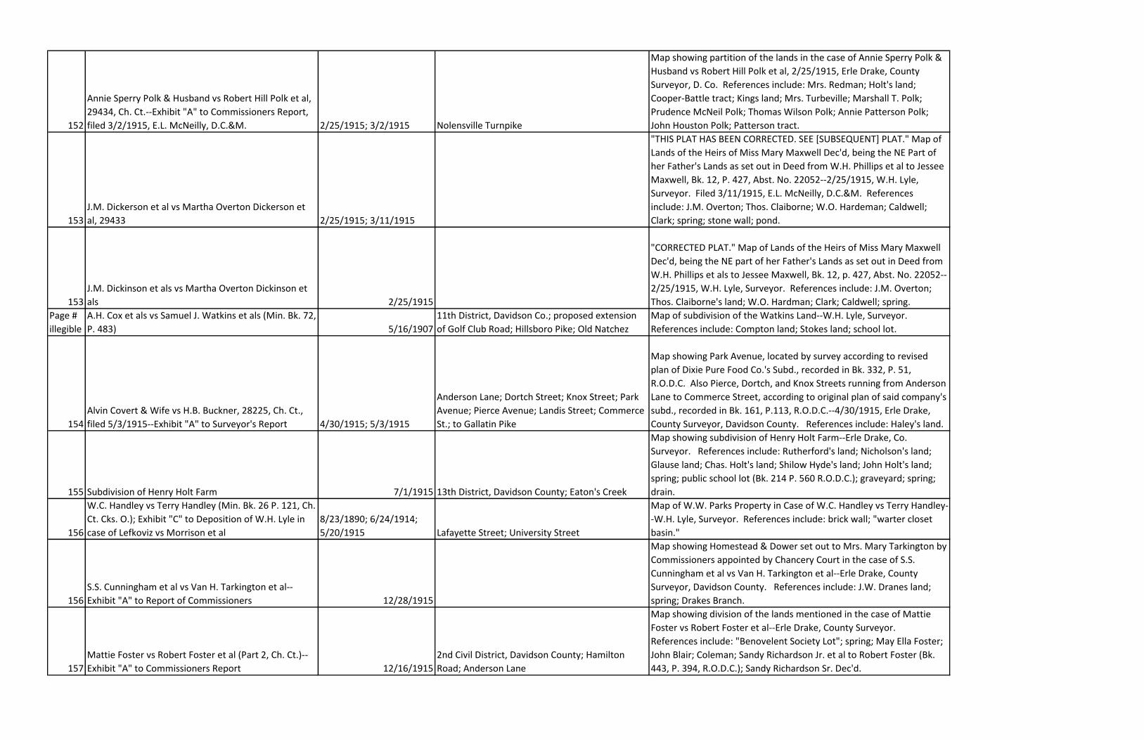
152
Annie Sperry Polk & Husband vs Robert Hill Polk et al,
29434, Ch. Ct.--Exhibit "A" to Commissioners Report,
filed 3/2/1915, E.L. McNeilly, D.C.&M. 2/25/1915; 3/2/1915 Nolensville Turnpike
Map showing partition of the lands in the case of Annie Sperry Polk &
Husband vs Robert Hill Polk et al, 2/25/1915, Erle Drake, County
Surveyor, D. Co. References include: Mrs. Redman; Holt's land;
Cooper-Battle tract; Kings land; Mrs. Turbeville; Marshall T. Polk;
Prudence McNeil Polk; Thomas Wilson Polk; Annie Patterson Polk;
John Houston Polk; Patterson tract.
153
J.M. Dickerson et al vs Martha Overton Dickerson et
al, 29433 2/25/1915; 3/11/1915
"THIS PLAT HAS BEEN CORRECTED. SEE [SUBSEQUENT] PLAT." Map of
Lands of the Heirs of Miss Mary Maxwell Dec'd, being the NE Part of
her Father's Lands as set out in Deed from W.H. Phillips et al to Jessee
Maxwell, Bk. 12, P. 427, Abst. No. 22052--2/25/1915, W.H. Lyle,
Surveyor. Filed 3/11/1915, E.L. McNeilly, D.C.&M. References
include: J.M. Overton; Thos. Claiborne; W.O. Hardeman; Caldwell;
Clark; spring; stone wall; pond.
153
J.M. Dickinson et als vs Martha Overton Dickinson et
als 2/25/1915
"CORRECTED PLAT." Map of Lands of the Heirs of Miss Mary Maxwell
Dec'd, being the NE part of her Father's Lands as set out in Deed from
W.H. Phillips et als to Jessee Maxwell, Bk. 12, p. 427, Abst. No. 22052--
2/25/1915, W.H. Lyle, Surveyor. References include: J.M. Overton;
Thos. Claiborne's land; W.O. Hardman; Clark; Caldwell; spring.
Page #
illegible
A.H. Cox et als vs Samuel J. Watkins et als (Min. Bk. 72,
P. 483) 5/16/1907
11th District, Davidson Co.; proposed extension
of Golf Club Road; Hillsboro Pike; Old Natchez
Map of subdivision of the Watkins Land--W.H. Lyle, Surveyor.
References include: Compton land; Stokes land; school lot.
154
Alvin Covert & Wife vs H.B. Buckner, 28225, Ch. Ct.,
filed 5/3/1915--Exhibit "A" to Surveyor's Report 4/30/1915; 5/3/1915
Anderson Lane; Dortch Street; Knox Street; Park
Avenue; Pierce Avenue; Landis Street; Commerce
St.; to Gallatin Pike
Map showing Park Avenue, located by survey according to revised
plan of Dixie Pure Food Co.'s Subd., recorded in Bk. 332, P. 51,
R.O.D.C. Also Pierce, Dortch, and Knox Streets running from Anderson
Lane to Commerce Street, according to original plan of said company's
subd., recorded in Bk. 161, P.113, R.O.D.C.--4/30/1915, Erle Drake,
County Surveyor, Davidson County. References include: Haley's land.
155 Subdivision of Henry Holt Farm 7/1/1915 13th District, Davidson County; Eaton's Creek
Map showing subdivision of Henry Holt Farm--Erle Drake, Co.
Surveyor. References include: Rutherford's land; Nicholson's land;
Glause land; Chas. Holt's land; Shilow Hyde's land; John Holt's land;
spring; public school lot (Bk. 214 P. 560 R.O.D.C.); graveyard; spring;
drain.
156
W.C. Handley vs Terry Handley (Min. Bk. 26 P. 121, Ch.
Ct. Cks. O.); Exhibit "C" to Deposition of W.H. Lyle in
case of Lefkoviz vs Morrison et al
8/23/1890; 6/24/1914;
5/20/1915 Lafayette Street; University Street
Map of W.W. Parks Property in Case of W.C. Handley vs Terry Handley-
-W.H. Lyle, Surveyor. References include: brick wall; "warter closet
basin."
156
S.S. Cunningham et al vs Van H. Tarkington et al--
Exhibit "A" to Report of Commissioners 12/28/1915
Map showing Homestead & Dower set out to Mrs. Mary Tarkington by
Commissioners appointed by Chancery Court in the case of S.S.
Cunningham et al vs Van H. Tarkington et al--Erle Drake, County
Surveyor, Davidson County. References include: J.W. Dranes land;
spring; Drakes Branch.
157
Mattie Foster vs Robert Foster et al (Part 2, Ch. Ct.)--
Exhibit "A" to Commissioners Report 12/16/1915
2nd Civil District, Davidson County; Hamilton
Road; Anderson Lane
Map showing division of the lands mentioned in the case of Mattie
Foster vs Robert Foster et al--Erle Drake, County Surveyor.
References include: "Benovelent Society Lot"; spring; May Ella Foster;
John Blair; Coleman; Sandy Richardson Jr. et al to Robert Foster (Bk.
443, P. 394, R.O.D.C.); Sandy Richardson Sr. Dec'd.
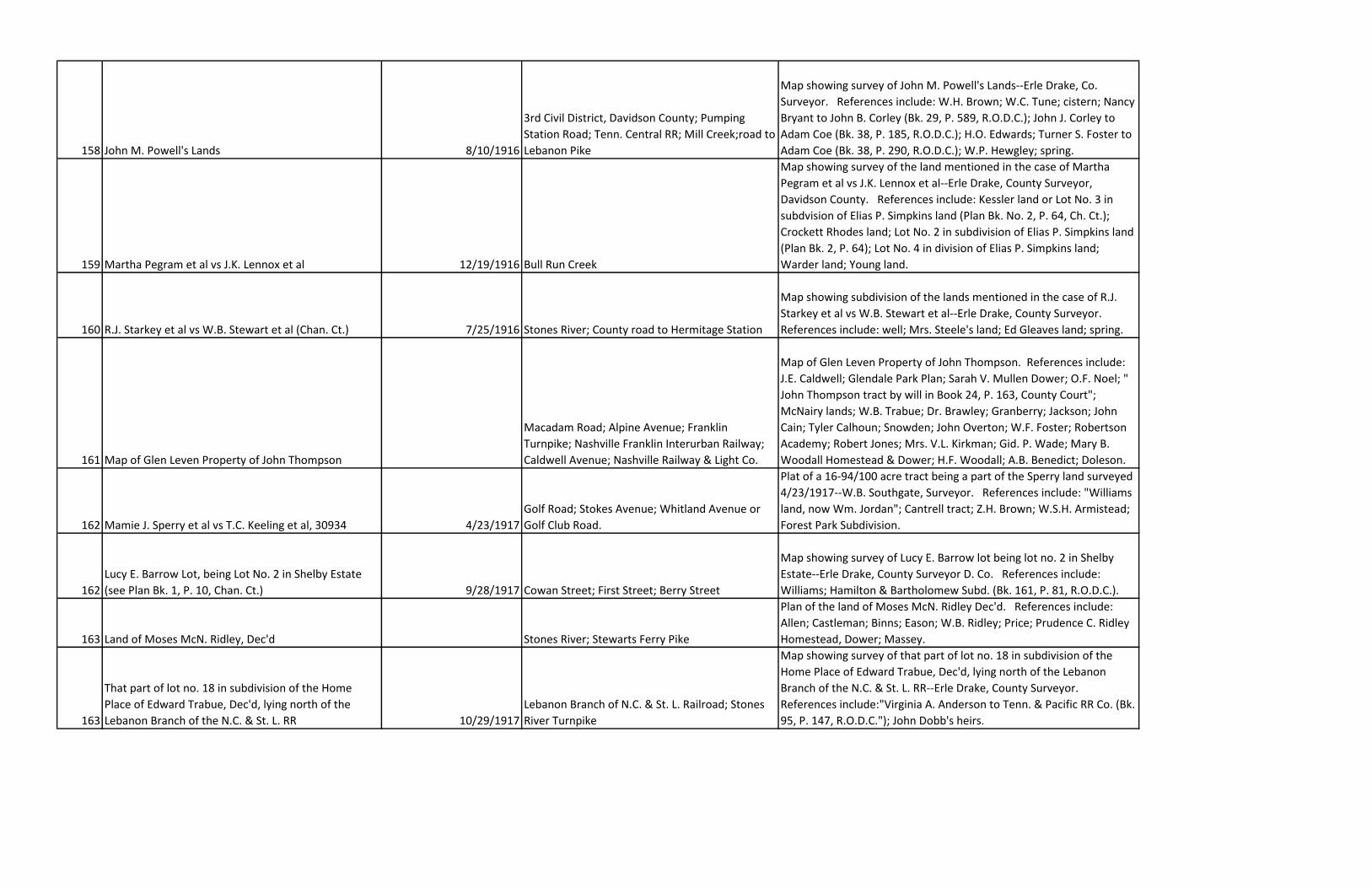
158 John M. Powell's Lands 8/10/1916
3rd Civil District, Davidson County; Pumping
Station Road; Tenn. Central RR; Mill Creek;road to
Lebanon Pike
Map showing survey of John M. Powell's Lands--Erle Drake, Co.
Surveyor. References include: W.H. Brown; W.C. Tune; cistern; Nancy
Bryant to John B. Corley (Bk. 29, P. 589, R.O.D.C.); John J. Corley to
Adam Coe (Bk. 38, P. 185, R.O.D.C.); H.O. Edwards; Turner S. Foster to
Adam Coe (Bk. 38, P. 290, R.O.D.C.); W.P. Hewgley; spring.
159 Martha Pegram et al vs J.K. Lennox et al 12/19/1916 Bull Run Creek
Map showing survey of the land mentioned in the case of Martha
Pegram et al vs J.K. Lennox et al--Erle Drake, County Surveyor,
Davidson County. References include: Kessler land or Lot No. 3 in
subdvision of Elias P. Simpkins land (Plan Bk. No. 2, P. 64, Ch. Ct.);
Crockett Rhodes land; Lot No. 2 in subdivision of Elias P. Simpkins land
(Plan Bk. 2, P. 64); Lot No. 4 in division of Elias P. Simpkins land;
Warder land; Young land.
160 R.J. Starkey et al vs W.B. Stewart et al (Chan. Ct.) 7/25/1916 Stones River; County road to Hermitage Station
Map showing subdivision of the lands mentioned in the case of R.J.
Starkey et al vs W.B. Stewart et al--Erle Drake, County Surveyor.
References include: well; Mrs. Steele's land; Ed Gleaves land; spring.
161 Map of Glen Leven Property of John Thompson
Macadam Road; Alpine Avenue; Franklin
Turnpike; Nashville Franklin Interurban Railway;
Caldwell Avenue; Nashville Railway & Light Co.
Map of Glen Leven Property of John Thompson. References include:
J.E. Caldwell; Glendale Park Plan; Sarah V. Mullen Dower; O.F. Noel; "
John Thompson tract by will in Book 24, P. 163, County Court";
McNairy lands; W.B. Trabue; Dr. Brawley; Granberry; Jackson; John
Cain; Tyler Calhoun; Snowden; John Overton; W.F. Foster; Robertson
Academy; Robert Jones; Mrs. V.L. Kirkman; Gid. P. Wade; Mary B.
Woodall Homestead & Dower; H.F. Woodall; A.B. Benedict; Doleson.
162 Mamie J. Sperry et al vs T.C. Keeling et al, 30934 4/23/1917
Golf Road; Stokes Avenue; Whitland Avenue or
Golf Club Road.
Plat of a 16-94/100 acre tract being a part of the Sperry land surveyed
4/23/1917--W.B. Southgate, Surveyor. References include: "Williams
land, now Wm. Jordan"; Cantrell tract; Z.H. Brown; W.S.H. Armistead;
Forest Park Subdivision.
162
Lucy E. Barrow Lot, being Lot No. 2 in Shelby Estate
(see Plan Bk. 1, P. 10, Chan. Ct.) 9/28/1917 Cowan Street; First Street; Berry Street
Map showing survey of Lucy E. Barrow lot being lot no. 2 in Shelby
Estate--Erle Drake, County Surveyor D. Co. References include:
Williams; Hamilton & Bartholomew Subd. (Bk. 161, P. 81, R.O.D.C.).
163 Land of Moses McN. Ridley, Dec'd Stones River; Stewarts Ferry Pike
Plan of the land of Moses McN. Ridley Dec'd. References include:
Allen; Castleman; Binns; Eason; W.B. Ridley; Price; Prudence C. Ridley
Homestead, Dower; Massey.
163
That part of lot no. 18 in subdivision of the Home
Place of Edward Trabue, Dec'd, lying north of the
Lebanon Branch of the N.C. & St. L. RR 10/29/1917
Lebanon Branch of N.C. & St. L. Railroad; Stones
River Turnpike
Map showing survey of that part of lot no. 18 in subdivision of the
Home Place of Edward Trabue, Dec'd, lying north of the Lebanon
Branch of the N.C. & St. L. RR--Erle Drake, County Surveyor.
References include:"Virginia A. Anderson to Tenn. & Pacific RR Co. (Bk.
95, P. 147, R.O.D.C."); John Dobb's heirs.
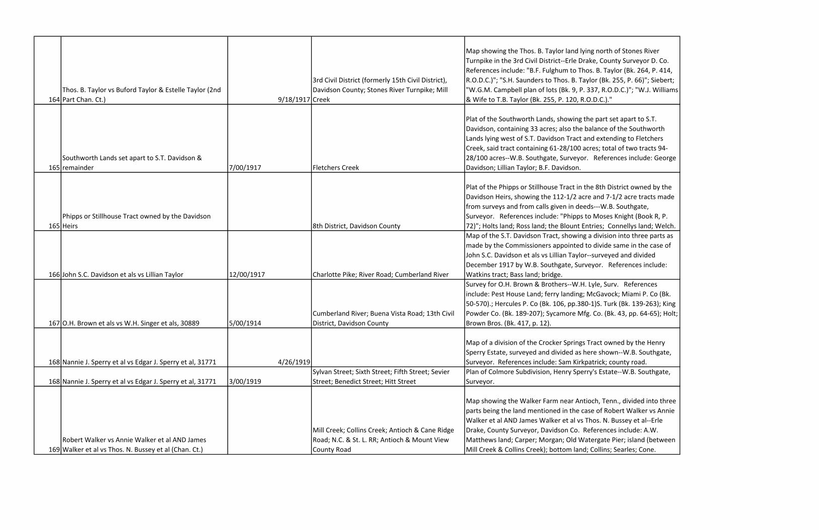
164
Thos. B. Taylor vs Buford Taylor & Estelle Taylor (2nd
Part Chan. Ct.) 9/18/1917
3rd Civil District (formerly 15th Civil District),
Davidson County; Stones River Turnpike; Mill
Creek
Map showing the Thos. B. Taylor land lying north of Stones River
Turnpike in the 3rd Civil District--Erle Drake, County Surveyor D. Co.
References include: "B.F. Fulghum to Thos. B. Taylor (Bk. 264, P. 414,
R.O.D.C.)"; "S.H. Saunders to Thos. B. Taylor (Bk. 255, P. 66)"; Siebert;
"W.G.M. Campbell plan of lots (Bk. 9, P. 337, R.O.D.C.)"; "W.J. Williams
& Wife to T.B. Taylor (Bk. 255, P. 120, R.O.D.C.)."
165
Southworth Lands set apart to S.T. Davidson &
remainder 7/00/1917 Fletchers Creek
Plat of the Southworth Lands, showing the part set apart to S.T.
Davidson, containing 33 acres; also the balance of the Southworth
Lands lying west of S.T. Davidson Tract and extending to Fletchers
Creek, said tract containing 61-28/100 acres; total of two tracts 94-
28/100 acres--W.B. Southgate, Surveyor. References include: George
Davidson; Lillian Taylor; B.F. Davidson.
165
Phipps or Stillhouse Tract owned by the Davidson
Heirs 8th District, Davidson County
Plat of the Phipps or Stillhouse Tract in the 8th District owned by the
Davidson Heirs, showing the 112-1/2 acre and 7-1/2 acre tracts made
from surveys and from calls given in deeds---W.B. Southgate,
Surveyor. References include: "Phipps to Moses Knight (Book R, P.
72)"; Holts land; Ross land; the Blount Entries; Connellys land; Welch.
166 John S.C. Davidson et als vs Lillian Taylor 12/00/1917 Charlotte Pike; River Road; Cumberland River
Map of the S.T. Davidson Tract, showing a division into three parts as
made by the Commissioners appointed to divide same in the case of
John S.C. Davidson et als vs Lillian Taylor--surveyed and divided
December 1917 by W.B. Southgate, Surveyor. References include:
Watkins tract; Bass land; bridge.
167 O.H. Brown et als vs W.H. Singer et als, 30889 5/00/1914
Cumberland River; Buena Vista Road; 13th Civil
District, Davidson County
Survey for O.H. Brown & Brothers--W.H. Lyle, Surv. References
include: Pest House Land; ferry landing; McGavock; Miami P. Co (Bk.
50-570).; Hercules P. Co (Bk. 106, pp.380-1)S. Turk (Bk. 139-263); King
Powder Co. (Bk. 189-207); Sycamore Mfg. Co. (Bk. 43, pp. 64-65); Holt;
Brown Bros. (Bk. 417, p. 12).
168 Nannie J. Sperry et al vs Edgar J. Sperry et al, 31771 4/26/1919
Map of a division of the Crocker Springs Tract owned by the Henry
Sperry Estate, surveyed and divided as here shown--W.B. Southgate,
Surveyor. References include: Sam Kirkpatrick; county road.
168 Nannie J. Sperry et al vs Edgar J. Sperry et al, 31771 3/00/1919
Sylvan Street; Sixth Street; Fifth Street; Sevier
Street; Benedict Street; Hitt Street
Plan of Colmore Subdivision, Henry Sperry's Estate--W.B. Southgate,
Surveyor.
169
Robert Walker vs Annie Walker et al AND James
Walker et al vs Thos. N. Bussey et al (Chan. Ct.)
Mill Creek; Collins Creek; Antioch & Cane Ridge
Road; N.C. & St. L. RR; Antioch & Mount View
County Road
Map showing the Walker Farm near Antioch, Tenn., divided into three
parts being the land mentioned in the case of Robert Walker vs Annie
Walker et al AND James Walker et al vs Thos. N. Bussey et al--Erle
Drake, County Surveyor, Davidson Co. References include: A.W.
Matthews land; Carper; Morgan; Old Watergate Pier; island (between
Mill Creek & Collins Creek); bottom land; Collins; Searles; Cone.
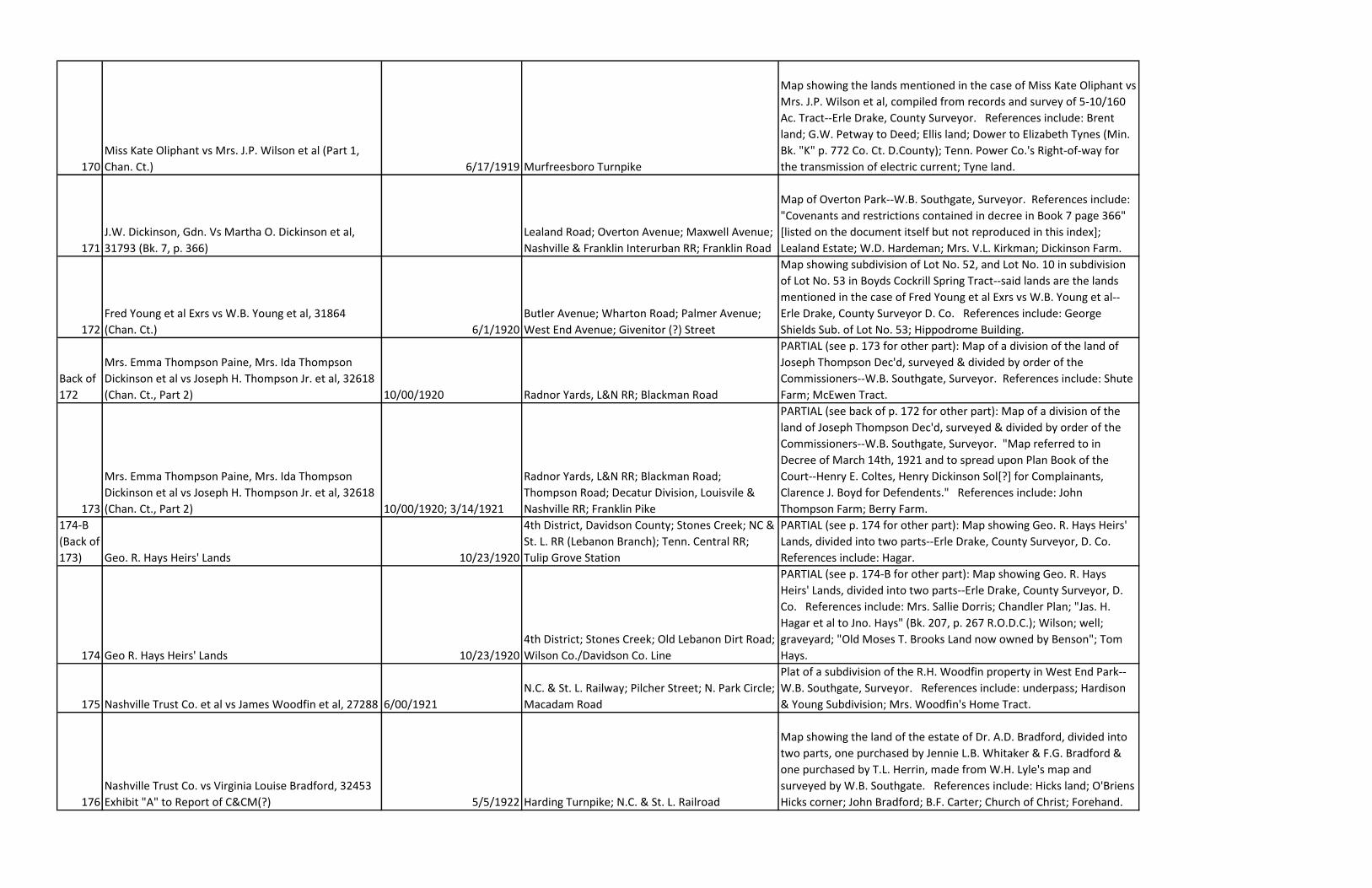
170
Miss Kate Oliphant vs Mrs. J.P. Wilson et al (Part 1,
Chan. Ct.) 6/17/1919 Murfreesboro Turnpike
Map showing the lands mentioned in the case of Miss Kate Oliphant vs
Mrs. J.P. Wilson et al, compiled from records and survey of 5-10/160
Ac. Tract--Erle Drake, County Surveyor. References include: Brent
land; G.W. Petway to Deed; Ellis land; Dower to Elizabeth Tynes (Min.
Bk. "K" p. 772 Co. Ct. D.County); Tenn. Power Co.'s Right-of-way for
the transmission of electric current; Tyne land.
171
J.W. Dickinson, Gdn. Vs Martha O. Dickinson et al,
31793 (Bk. 7, p. 366)
Lealand Road; Overton Avenue; Maxwell Avenue;
Nashville & Franklin Interurban RR; Franklin Road
Map of Overton Park--W.B. Southgate, Surveyor. References include:
"Covenants and restrictions contained in decree in Book 7 page 366"
[listed on the document itself but not reproduced in this index];
Lealand Estate; W.D. Hardeman; Mrs. V.L. Kirkman; Dickinson Farm.
172
Fred Young et al Exrs vs W.B. Young et al, 31864
(Chan. Ct.) 6/1/1920
Butler Avenue; Wharton Road; Palmer Avenue;
West End Avenue; Givenitor (?) Street
Map showing subdivision of Lot No. 52, and Lot No. 10 in subdivision
of Lot No. 53 in Boyds Cockrill Spring Tract--said lands are the lands
mentioned in the case of Fred Young et al Exrs vs W.B. Young et al--
Erle Drake, County Surveyor D. Co. References include: George
Shields Sub. of Lot No. 53; Hippodrome Building.
Back of
172
Mrs. Emma Thompson Paine, Mrs. Ida Thompson
Dickinson et al vs Joseph H. Thompson Jr. et al, 32618
(Chan. Ct., Part 2) 10/00/1920 Radnor Yards, L&N RR; Blackman Road
PARTIAL (see p. 173 for other part): Map of a division of the land of
Joseph Thompson Dec'd, surveyed & divided by order of the
Commissioners--W.B. Southgate, Surveyor. References include: Shute
Farm; McEwen Tract.
173
Mrs. Emma Thompson Paine, Mrs. Ida Thompson
Dickinson et al vs Joseph H. Thompson Jr. et al, 32618
(Chan. Ct., Part 2) 10/00/1920; 3/14/1921
Radnor Yards, L&N RR; Blackman Road;
Thompson Road; Decatur Division, Louisvile &
Nashville RR; Franklin Pike
PARTIAL (see back of p. 172 for other part): Map of a division of the
land of Joseph Thompson Dec'd, surveyed & divided by order of the
Commissioners--W.B. Southgate, Surveyor. "Map referred to in
Decree of March 14th, 1921 and to spread upon Plan Book of the
Court--Henry E. Coltes, Henry Dickinson Sol[?] for Complainants,
Clarence J. Boyd for Defendents." References include: John
Thompson Farm; Berry Farm.
174-B
(Back of
173) Geo. R. Hays Heirs' Lands 10/23/1920
4th District, Davidson County; Stones Creek; NC &
St. L. RR (Lebanon Branch); Tenn. Central RR;
Tulip Grove Station
PARTIAL (see p. 174 for other part): Map showing Geo. R. Hays Heirs'
Lands, divided into two parts--Erle Drake, County Surveyor, D. Co.
References include: Hagar.
174 Geo R. Hays Heirs' Lands 10/23/1920
4th District; Stones Creek; Old Lebanon Dirt Road;
Wilson Co./Davidson Co. Line
PARTIAL (see p. 174-B for other part): Map showing Geo. R. Hays
Heirs' Lands, divided into two parts--Erle Drake, County Surveyor, D.
Co. References include: Mrs. Sallie Dorris; Chandler Plan; "Jas. H.
Hagar et al to Jno. Hays" (Bk. 207, p. 267 R.O.D.C.); Wilson; well;
graveyard; "Old Moses T. Brooks Land now owned by Benson"; Tom
Hays.
175 Nashville Trust Co. et al vs James Woodfin et al, 27288 6/00/1921
N.C. & St. L. Railway; Pilcher Street; N. Park Circle;
Macadam Road
Plat of a subdivision of the R.H. Woodfin property in West End Park--
W.B. Southgate, Surveyor. References include: underpass; Hardison
& Young Subdivision; Mrs. Woodfin's Home Tract.
176
Nashville Trust Co. vs Virginia Louise Bradford, 32453
Exhibit "A" to Report of C&CM(?) 5/5/1922 Harding Turnpike; N.C. & St. L. Railroad
Map showing the land of the estate of Dr. A.D. Bradford, divided into
two parts, one purchased by Jennie L.B. Whitaker & F.G. Bradford &
one purchased by T.L. Herrin, made from W.H. Lyle's map and
surveyed by W.B. Southgate. References include: Hicks land; O'Briens
Hicks corner; John Bradford; B.F. Carter; Church of Christ; Forehand.
177
Nashville Trust Co. vs Virginia Louise Bradford, 32453,
Exhibit "E" to bill filed 9/21/1920, C.H. Swann, D.C.&
M. 2/4-6/1901; 9/21/1920
14th District, Davidson Co.; Harding Turnpike;
N.C. & St. L. RR
Map showing Tract No. 2 of the lands of the heirs of Frederic Bradford
Dec'd, processioned & subdivided Feb. 4-6, 1901--W.H. Lyle, Surveyor.
"This certifies that I surveyed and divided two tracts of this part of the
Bradford lands…done by request of Dr. A.D. Bradford of the Heirs--E.R.
Southgate, Co. Surveyor D. Co." References include: Hicks land;
O'Brien's lans ; Mrs. Lou H. Sneed; John Bradford; B.F. Carter; C.H.
Forehand; Catholic Church.
178
John F. Weakley et al vs Robert Young et al, 31704
(Part 1, Chancery Court) 2/21/1922 Cumberland River
Map showing subdivision of the land involved in the case of John F.
Weakley et al vs Robert Young et al--Erle Drake, County Surveyor.
References include: Dr. Olin; R. Young; "6 Ac. Tract conveyed by H.B.
Chadwell to John Nevin" (Bk. 469, p. 109 R.O.D.C.); Pennington Land
Tract; "Lot No. 4 of Chan. Ct. Plan Bk.1 P. 40"; county road; spring;
island.
179
W.W. Hessey & Richard L. Hessey vs Mary Hessey et
al, Part 1 Ch. Ct., 34506 (Decree Min. Bk. 103 P. 500)--
Exhibit "A" to Report of Commissioners M.C. Wright,
T.M. Dodson, & Erle Drake, Co. Surveyor 3/5/1923 Stones River
Map showing division & allotment to the heirs of L.C. Hessey & Addie
Scott Hessey of the lands involved in the case of W.W. Hessey &
Richard L. Hessey vs Mary Hessey et al. References include: Joe
Gleaves land; W.F. Stevens land; C.C. Hessey; John Hessey; Scott
Hessey; D.M. Hessey; Martha Hessey; Mrs. Evelyn Turner; Mrs. Nina
Steele; Walter W. Hessey.
180
Albert Duling vs Henry Cunningham (Chan. Ct.), 31124-
-Exhibit to Report of Commissioners Goodloe Cockrill,
T.G. McCampbell, & Erle Drake. 3/12/1923 Owen Winstead Pike
Map showing division & allotment of the lands involved in the case of
Albert Duling vs Henry Cunningham--Erle Drake, Co. Surveyor.
References include: Jim Rucker; J.A. Carter; Emily Warren; Joe Rucker;
Jacob Cunningham; Nannie Cunningham; Samella Cunningham; Jim
Rucker.
181
E.C. Scruggs vs Gene Thomas et al, 34801 (Decree
Book 12, page 162) 2/16/1923 Taylor Lane
Map of land sold by E.C. Scruggs as surveyed Feby. 16, 1923--John
Wilkes, C.E. References include: rock wall.
182 G.H. Austin et al vs Robt. Austin et al, 34324 2/22/1923
5th District, Davidson Co.; Hobson Turnpike;
Nolensville Road
Map showing survey of the N.C. Austin Lands--Erle Drake, County
Surveyor. References include: Mike Barnes; J.P. Briley; R.S. Austin;
E.H. Johnson; W.H. Burkett.
183?
(attach
ed to
front of Subdivision of lands of Weaver, Harris et al 5/10/1923
14th Civil District, Davidson Co.; Goodlettsville
Pike; Morgan Road; "(Old Ridge)"; Loggins Spring;
Sulphur Branch; Wilkerson Road
Subdivision of lands of Weaver, Harris et al--M.B. Knight, Surveyor.
References include: C.J. Knight & N.V. Williams, C.C.; Jeff Raymer,
Flagman; W.W. Southgate sur.; Hunter House; Will Jones; Will Cost.
183
Dempsey Weaver et al vs Bettie C. Weaver et al,
35040 5/10/1923
14th Civil District, Davidson County;
Goodlettsville Pike; Loggins Spring; Sulphur
Branch; Morgan Road; Old Ridge
Subdivision of lands of Weaver, Harris et al--M.B. Knight, Surveyor.
References include: C.J. Knight & N.V. Williams, C.C.; Jeff Raymer,
Flagman; W.W. Southgate sur.; Hunter House; Will Jones; Will Cost.
184
F.J. Nolan, Guardian, et al vs Margaret Nolan Johnson
et al, 35468 (Min. Bk. 13, p. 444) 12/1/1923 Acklen Avenue; Eighth Avenue S.
Plat of the north part of Lot No. 100 in Waverly Place--W.B. Southgate,
Surveyor.
185
Revision of Bass & Woolwine Subdivision of the
Hobson Chapel Property (Bk. 57, P. 96 R.O.D.C.) 1/00/1925 Woodland; Lindsley; Tenth Street
Revision of Bass & Woolwine Subdivision of the Hobson Chapel
Property--Boon Denton, Surveyor. References include: grocery;
"REOL"; Tel. Ex. Bldg.


![IN THE CHANCERY COURT FOR DAVIDSON …...12. As currently construed, the Excuse Requirement prevents Ms. from Greenawalt “vot[ing] absentee by mail.” See Tenn. Code Ann. 2-6-201](https://img.pdfslide.net/doc/110x75/5f437bc2f4773264011e6c46/in-the-chancery-court-for-davidson-12-as-currently-construed-the-excuse-requirement.jpg)