Embed Size (px)
Citation preview

RIETKLOOF WIND FARM BA
AGRICULTURAL AND SOIL ASSESSMENT
Prepared for:
Rietkloof Wind Farm (Pty) Ltd.
Prepared by:
EAST LONDON 25 Tecoma street
Berea, East London, 5201 043 726 7809
Also in Cape Town, Johannesburg, Grahamstown, Port Elizabeth and Maputo (Mozambique)
www.cesnet.co.za or www.eoh.co.za
June 2018

Agricultural & Soil Assessment – June 2018
EOH Coastal & Environmental Services i Rietkloof WEF
REVISIONS TRACKING TABLE
EOH Coastal and Environmental Services
Report Title: Rietkloof Wind Farm BA: Agricultural and Soil Assessment Report Version: Final Report Project Number: 299
Name Report version Signature Date
Roy de Kock
Final Report
16 March 2016
Updated report
29 June 2018
Updated report with client comments
30 July 2019
Copyright
This document contains intellectual property and proprietary information that is protected by copyright in favour of Coastal & Environmental Services (Pty) Ltd. (and the specialist
consultants). The document may therefore not be reproduced, used or distributed to any third party without the prior written consent of Coastal & Environmental Services. Although this
document is prepared exclusively for submission to the Department of Environmental Affairs, Coastal & Environmental Services (Pty) Ltd retains ownership of the intellectual property and proprietary information contained herein, which is subject to all confidentiality, copyright and
trade secrets, rules intellectual property law and practices of South Africa.
Agricultural & Soil Assessment – June 2018
EOH Coastal & Environmental Services ii Rietkloof WEF
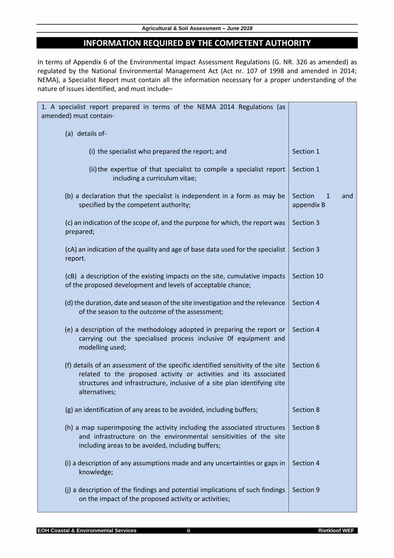
INFORMATION REQUIRED BY THE COMPETENT AUTHORITY In terms of Appendix 6 of the Environmental Impact Assessment Regulations (G. NR. 326 as amended) as regulated by the National Environmental Management Act (Act nr. 107 of 1998 and amended in 2014; NEMA), a Specialist Report must contain all the information necessary for a proper understanding of the nature of issues identified, and must include–
1. A specialist report prepared in terms of the NEMA 2014 Regulations (as amended) must contain-
(a) details of-
(i) the specialist who prepared the report; and (ii) the expertise of that specialist to compile a specialist report
including a curriculum vitae;
(b) a declaration that the specialist is independent in a form as may be specified by the competent authority;
(c) an indication of the scope of, and the purpose for which, the report was prepared; (cA) an indication of the quality and age of base data used for the specialist report. (cB) a description of the existing impacts on the site, cumulative impacts of the proposed development and levels of acceptable chance; (d) the duration, date and season of the site investigation and the relevance
of the season to the outcome of the assessment; (e) a description of the methodology adopted in preparing the report or
carrying out the specialised process inclusive 0f equipment and modelling used;
(f) details of an assessment of the specific identified sensitivity of the site
related to the proposed activity or activities and its associated structures and infrastructure, inclusive of a site plan identifying site alternatives;
(g) an identification of any areas to be avoided, including buffers; (h) a map superimposing the activity including the associated structures
and infrastructure on the environmental sensitivities of the site including areas to be avoided, including buffers;
(i) a description of any assumptions made and any uncertainties or gaps in
knowledge; (j) a description of the findings and potential implications of such findings
on the impact of the proposed activity or activities;
Section 1 Section 1 Section 1 and appendix B Section 3 Section 3 Section 10 Section 4 Section 4 Section 6 Section 8 Section 8 Section 4 Section 9

Agricultural & Soil Assessment – June 2018
EOH Coastal & Environmental Services iii Rietkloof WEF
(k) any mitigation measures for inclusion in the EMPr; (I) any conditions for inclusion in the environmental authorisation; (m) any monitoring requirements for inclusion in the EMPr or environmental authorisation; (n) a reasoned opinion-
(i) whether the proposed activity, activities or portions thereof should be authorised;
(iA) regarding the acceptability of the proposed activity or
activities; and (ii) if the opinion is that the proposed activity or portions thereof
should be authorised, any avoidance, management and mitigation measures that should be included in the EMPr, and where applicable, the closure plan;
(o) a description of any consultation process that was undertaken during
the course of preparing the specialist report; (p) a summary and copies of any comments received during any
consultation process and where applicable all responses thereto; and
(q) any other information requested by the competent authority.
2. Where a government notice gazetted by the Mininster provides for a protocol or minimum information requirement to be applied to a specialist report, the requirements as indicated in such notice will apply.
Section 9 Section 10 Section 10 Section 10 Section 10 Section 10 Section 3 Section 3 Section 3 N/A
Agricultural & Soil Assessment – June 2018
EOH Coastal & Environmental Services 1 Rietkloof WEF
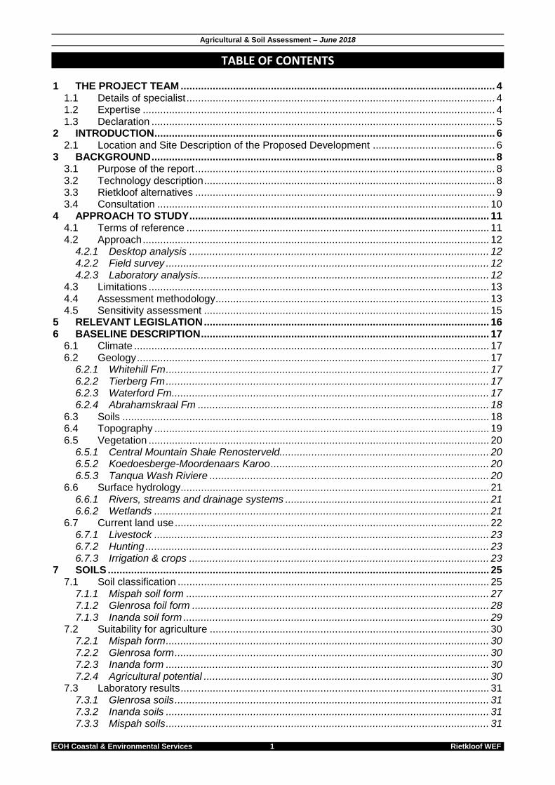
TABLE OF CONTENTS 1 THE PROJECT TEAM ............................................................................................................ 4
1.1 Details of specialist .......................................................................................................... 4 1.2 Expertise ......................................................................................................................... 4 1.3 Declaration ...................................................................................................................... 5
2 INTRODUCTION ..................................................................................................................... 6 2.1 Location and Site Description of the Proposed Development .......................................... 6
3 BACKGROUND ...................................................................................................................... 8 3.1 Purpose of the report ....................................................................................................... 8 3.2 Technology description .................................................................................................... 8 3.3 Rietkloof alternatives ....................................................................................................... 9 3.4 Consultation .................................................................................................................. 10
4 APPROACH TO STUDY ....................................................................................................... 11 4.1 Terms of reference ........................................................................................................ 11 4.2 Approach ....................................................................................................................... 12
4.2.1 Desktop analysis ....................................................................................................... 12 4.2.2 Field survey ............................................................................................................... 12 4.2.3 Laboratory analysis .................................................................................................... 12
4.3 Limitations ..................................................................................................................... 13 4.4 Assessment methodology .............................................................................................. 13 4.5 Sensitivity assessment .................................................................................................. 15
5 RELEVANT LEGISLATION .................................................................................................. 16 6 BASELINE DESCRIPTION ................................................................................................... 17
6.1 Climate .......................................................................................................................... 17 6.2 Geology ......................................................................................................................... 17
6.2.1 Whitehill Fm ............................................................................................................... 17 6.2.2 Tierberg Fm ............................................................................................................... 17 6.2.3 Waterford Fm ............................................................................................................. 17 6.2.4 Abrahamskraal Fm .................................................................................................... 18
6.3 Soils .............................................................................................................................. 18 6.4 Topography ................................................................................................................... 19 6.5 Vegetation ..................................................................................................................... 20
6.5.1 Central Mountain Shale Renosterveld........................................................................ 20 6.5.2 Koedoesberge-Moordenaars Karoo ........................................................................... 20 6.5.3 Tanqua Wash Riviere ................................................................................................ 20
6.6 Surface hydrology .......................................................................................................... 21 6.6.1 Rivers, streams and drainage systems ...................................................................... 21 6.6.2 Wetlands ................................................................................................................... 21
6.7 Current land use ............................................................................................................ 22 6.7.1 Livestock ................................................................................................................... 23 6.7.2 Hunting ...................................................................................................................... 23 6.7.3 Irrigation & crops ....................................................................................................... 23
7 SOILS ................................................................................................................................... 25 7.1 Soil classification ........................................................................................................... 25
7.1.1 Mispah soil form ........................................................................................................ 27 7.1.2 Glenrosa foil form ...................................................................................................... 28 7.1.3 Inanda soil form ......................................................................................................... 29
7.2 Suitability for agriculture ................................................................................................ 30 7.2.1 Mispah form ............................................................................................................... 30 7.2.2 Glenrosa form ............................................................................................................ 30 7.2.3 Inanda form ............................................................................................................... 30 7.2.4 Agricultural potential .................................................................................................. 30
7.3 Laboratory results .......................................................................................................... 31 7.3.1 Glenrosa soils ............................................................................................................ 31 7.3.2 Inanda soils ............................................................................................................... 31 7.3.3 Mispah soils ............................................................................................................... 31

Agricultural & Soil Assessment – June 2018
EOH Coastal & Environmental Services 2 Rietkloof WEF
7.3.4 Conclusion on agricultural suitability .......................................................................... 32 8 SENSITIVITY ASSESSMENT ............................................................................................... 33 9 IMPACT IDENTIFICATION AND ASSESSMENT ................................................................. 34
9.1 Introduction .................................................................................................................... 34 9.2 Impacts on soils and agriculture .................................................................................... 34 9.3 Impact Assessment ....................................................................................................... 36
10 IMPACT STATEMENT, CONCLUSION AND RECOMMENDATIONS.................................. 51 10.1 Environmental management programme ....................................................................... 51 10.2 Cumulative impacts ....................................................................................................... 51
10.2.1 Discussion ............................................................................................................. 51 10.2.2 Impact statement ................................................................................................... 52 10.2.3 Conclusion ............................................................................................................. 53
10.3 Recommendations for the proposed Rietkloof WEF ...................................................... 53 10.3.1 Alternatives ............................................................................................................ 53 10.3.2 Sensitive croplands ................................................................................................ 54 10.3.3 Mitigation measures ............................................................................................... 55
10.4 Conclusions ................................................................................................................... 56 10.5 Agricultural statement and Opinion of the Specialist ...................................................... 57
11 REFERENCES...................................................................................................................... 58 12 APPENDIX A – SOIL LABORATORY RESULTS ................................................................. 59 13 APPENDIX B – SPECIALIST DECLARATION ..................................................................... 60
LIST OF FIGURES Figure 2.1: Proposed Location for the Rietkloof WEF. .......................................................................................... 7 Figure 3.1: Layout map of the proposed Rietkloof WEF ....................................................................................... 9 Figure 6.1: Geology of the Rietkloof WEF ............................................................................................................ 18 Figure 6.2: Topography of the proposed Rietkloof WEF ..................................................................................... 19 Figure 6.5: Vegetation map of the Rietkloof WEF area ....................................................................................... 21 Figure 6.6: Surface water map of the Rietkloof WEF area .................................................................................. 22 Figure 6.7: Infrastructure located close to or within water bodies. ..................................................................... 22 Figure 6.8: Irrigation map of the Rietkloof WEF area .......................................................................................... 24 Figure 7.1: Soil distribution map for the Rietkloof WEF ....................................................................................... 27 Figure 8.1: Agricultural sensitivity map of the Rietkloof Wind farm area ............................................................ 33 Figure 10.1. Renewable projects within 50km of the proposed Rietkloof Wind Farm. ...................................... 52
LIST OF TABLES Table 2.1: Farm Portions on which the Proposed Development is Located. ....................................................... 6 Table 3.1: Various alternatives proposed for the Rietkloof WEF. ......................................................................... 9 Table 7.3: Total Exchange Capacity (TEC) for the different soil types (Moore et al, 1998). ............................ 13 Table 4.1: Ranking of Evaluation Criteria ............................................................................................................. 14 Table 4.2.: Description of Environmental Significance Ratings .......................................................................... 14 Table 4.3: Criteria used for the analysis of the agricultural sensitivity of the area. ........................................... 15 Table 5.1: Legislation and other regulatory instruments considered in the preparation of the Rietkloof WEF Soil
and Agricultural Report. ................................................................................................................................. 16 Table 6.1: Generalised soil status for the Rietkloof WEF (Source: www.agis.agric.za).................................... 19 Table 7.1: Coordinated of the 5 x soil sample sites ............................................................................................. 25 Table 7.2: Visual description of the 5 sites sampled within the Rietkloof WEF ................................................. 25 Table 7.4: Average soil conditions within the Rietkloof WEF site ....................................................................... 31 Table 9.1: Impacts to soil and agriculture associated with different phases of the proposed Rietkloof Wind Farm
......................................................................................................................................................................... 34 Table 9.2: Assessment and mitigation of impacts identified in the Planning & Design Phase. ........................ 37 Table 9.2: Assessment and mitigation of impacts identified in the Construction Phase. .................................. 39 Table 9.3: Assessment and mitigation of impacts identified in the Operational Phase. .................................... 48 Table 9.5: Assessment and mitigation of impacts identified in the Decommissioning Phase. ......................... 50 Table 9.6: Assessment and mitigation of impacts identified in the NO-GO alternative. .................................... 50

Agricultural & Soil Assessment – June 2018
EOH Coastal & Environmental Services 3 Rietkloof WEF
Table 10.1. Assessment of pre- and post-mitigation impact significance. ......................................................... 57
LIST OF PLATES Plate 7.1: Photos of Mispah soil forms found onsite ............................................................................................ 28 Plate 7.2: Photos of Glenrosa soil forms found onsite ......................................................................................... 29
LIST OF ACRONYMS AND GLOSSARY
AGIS Agricultural Geo-Referenced Information System
CARA Conservation of Agricultural Resources Act
DAFF Department of Agriculture, Forestry & Fisheries
DEA Department of Environmental Affairs
DWS Department of Water and Sanitation
EC Eastern Cape
EIA Environmental Impact Assessment
GDP Gross Domestic Product
ha hectare
kV kilovolt
KZN Kwazulu-Natal
Ma Million years
masl Meters above sea level
MW Mega Watt
NEMA National Environmental Management Act
NEMBA National Environmental Management Biodiversity Act
SDF Spatial Development Framework
Agricultural & Soil Assessment – June 2018
EOH Coastal & Environmental Services 4 Rietkloof WEF
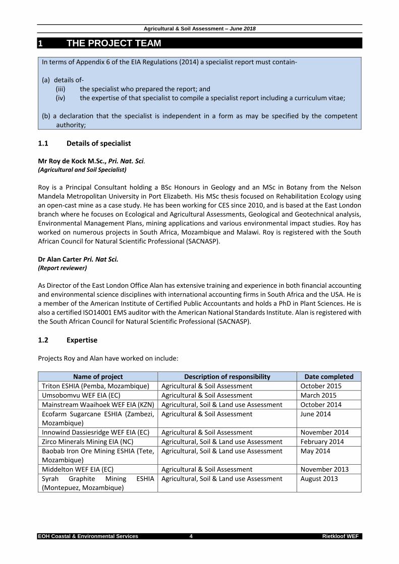
1 THE PROJECT TEAM
In terms of Appendix 6 of the EIA Regulations (2014) a specialist report must contain- (a) details of-
(iii) the specialist who prepared the report; and (iv) the expertise of that specialist to compile a specialist report including a curriculum vitae;
(b) a declaration that the specialist is independent in a form as may be specified by the competent
authority;
1.1 Details of specialist Mr Roy de Kock M.Sc., Pri. Nat. Sci. (Agricultural and Soil Specialist)
Roy is a Principal Consultant holding a BSc Honours in Geology and an MSc in Botany from the Nelson Mandela Metropolitan University in Port Elizabeth. His MSc thesis focused on Rehabilitation Ecology using an open-cast mine as a case study. He has been working for CES since 2010, and is based at the East London branch where he focuses on Ecological and Agricultural Assessments, Geological and Geotechnical analysis, Environmental Management Plans, mining applications and various environmental impact studies. Roy has worked on numerous projects in South Africa, Mozambique and Malawi. Roy is registered with the South African Council for Natural Scientific Professional (SACNASP). Dr Alan Carter Pri. Nat Sci. (Report reviewer)
As Director of the East London Office Alan has extensive training and experience in both financial accounting and environmental science disciplines with international accounting firms in South Africa and the USA. He is a member of the American Institute of Certified Public Accountants and holds a PhD in Plant Sciences. He is also a certified ISO14001 EMS auditor with the American National Standards Institute. Alan is registered with the South African Council for Natural Scientific Professional (SACNASP).
1.2 Expertise Projects Roy and Alan have worked on include:
Name of project Description of responsibility Date completed
Triton ESHIA (Pemba, Mozambique) Agricultural & Soil Assessment October 2015
Umsobomvu WEF EIA (EC) Agricultural & Soil Assessment March 2015
Mainstream Waaihoek WEF EIA (KZN) Agricultural, Soil & Land use Assessment October 2014
Ecofarm Sugarcane ESHIA (Zambezi, Mozambique)
Agricultural & Soil Assessment June 2014
Innowind Dassiesridge WEF EIA (EC) Agricultural & Soil Assessment November 2014
Zirco Minerals Mining EIA (NC) Agricultural, Soil & Land use Assessment February 2014
Baobab Iron Ore Mining ESHIA (Tete, Mozambique)
Agricultural, Soil & Land use Assessment May 2014
Middelton WEF EIA (EC) Agricultural & Soil Assessment November 2013
Syrah Graphite Mining ESHIA (Montepuez, Mozambique)
Agricultural, Soil & Land use Assessment August 2013

Agricultural & Soil Assessment – June 2018
EOH Coastal & Environmental Services 5 Rietkloof WEF
1.3 Declaration I, Roy de Kock, declare that, in terms of the National Environmental Management Act, 1998 (Act No. 107 of 1998), as amended and the Environmental Impact Assessment Regulations, 2014;
I act as the independent specialist in this application;
I will perform the work relating to the application in an objective manner, even if this results in views and findings that are not favourable to the applicant;
I declare that there are no circumstances that may compromise my objectivity in performing such work;
I have expertise in conducting the specialist report relevant to this application, including knowledge of the Act, Regulations and any guidelines that have relevance to the proposed activity;
I will comply with the Act, Regulations and all other applicable legislation;
I have no, and will not engage in, conflicting interests in the undertaking of the activity;
I undertake to disclose to the applicant and the competent authority all material information in my possession that reasonably has or may have the potential of influencing - any decision to be taken with respect to the application by the competent authority; and - the objectivity of any report, plan or document to be prepared by myself for submission to the competent authority;
all the particulars furnished by me in this report are true and correct; and
I realise that a false declaration is an offence in terms of regulation 48 and is punishable in terms of section 24F of the Act.
Refer to Appendix B for a signed DEA declaration of independence.
Agricultural & Soil Assessment – June 2018
EOH Coastal & Environmental Services 6 Rietkloof WEF
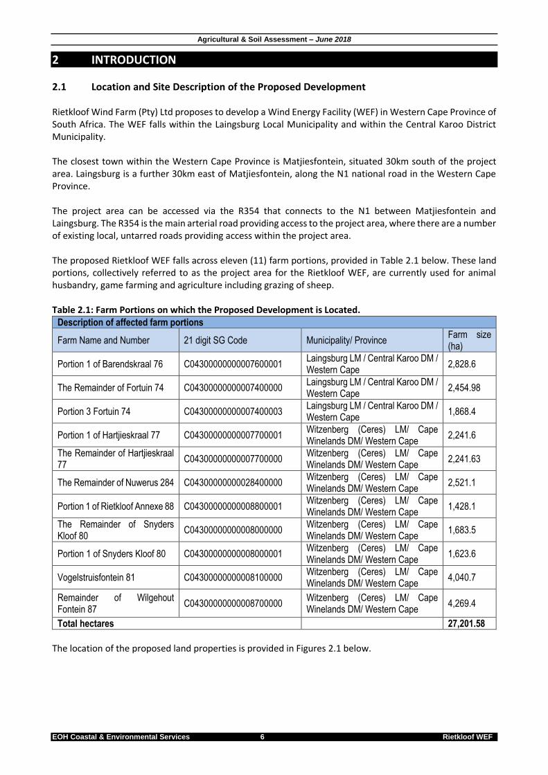
2 INTRODUCTION
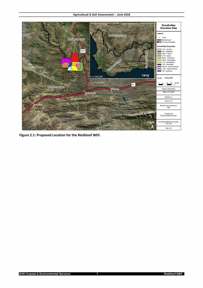
2.1 Location and Site Description of the Proposed Development Rietkloof Wind Farm (Pty) Ltd proposes to develop a Wind Energy Facility (WEF) in Western Cape Province of South Africa. The WEF falls within the Laingsburg Local Municipality and within the Central Karoo District Municipality. The closest town within the Western Cape Province is Matjiesfontein, situated 30km south of the project area. Laingsburg is a further 30km east of Matjiesfontein, along the N1 national road in the Western Cape Province. The project area can be accessed via the R354 that connects to the N1 between Matjiesfontein and Laingsburg. The R354 is the main arterial road providing access to the project area, where there are a number of existing local, untarred roads providing access within the project area. The proposed Rietkloof WEF falls across eleven (11) farm portions, provided in Table 2.1 below. These land portions, collectively referred to as the project area for the Rietkloof WEF, are currently used for animal husbandry, game farming and agriculture including grazing of sheep. Table 2.1: Farm Portions on which the Proposed Development is Located.
Description of affected farm portions
Farm Name and Number 21 digit SG Code Municipality/ Province Farm size (ha)
Portion 1 of Barendskraal 76 C04300000000007600001 Laingsburg LM / Central Karoo DM / Western Cape
2,828.6
The Remainder of Fortuin 74 C04300000000007400000 Laingsburg LM / Central Karoo DM / Western Cape
2,454.98
Portion 3 Fortuin 74 C04300000000007400003 Laingsburg LM / Central Karoo DM / Western Cape
1,868.4
Portion 1 of Hartjieskraal 77 C04300000000007700001 Witzenberg (Ceres) LM/ Cape Winelands DM/ Western Cape
2,241.6
The Remainder of Hartjieskraal 77
C04300000000007700000 Witzenberg (Ceres) LM/ Cape Winelands DM/ Western Cape
2,241.63
The Remainder of Nuwerus 284 C04300000000028400000 Witzenberg (Ceres) LM/ Cape Winelands DM/ Western Cape
2,521.1
Portion 1 of Rietkloof Annexe 88 C04300000000008800001 Witzenberg (Ceres) LM/ Cape Winelands DM/ Western Cape
1,428.1
The Remainder of Snyders Kloof 80
C04300000000008000000 Witzenberg (Ceres) LM/ Cape Winelands DM/ Western Cape
1,683.5
Portion 1 of Snyders Kloof 80 C04300000000008000001 Witzenberg (Ceres) LM/ Cape Winelands DM/ Western Cape
1,623.6
Vogelstruisfontein 81 C04300000000008100000 Witzenberg (Ceres) LM/ Cape Winelands DM/ Western Cape
4,040.7
Remainder of Wilgehout Fontein 87
C04300000000008700000 Witzenberg (Ceres) LM/ Cape Winelands DM/ Western Cape
4,269.4
Total hectares 27,201.58
The location of the proposed land properties is provided in Figures 2.1 below.
Agricultural & Soil Assessment – June 2018
EOH Coastal & Environmental Services 7 Rietkloof WEF
Figure 2.1: Proposed Location for the Rietkloof WEF.

Agricultural & Soil Assessment – June 2018
EOH Coastal & Environmental Services 8 Rietkloof WEF
3 BACKGROUND
In terms of Appendix 6 of the EIA Regulations (2014) a specialist report must contain- (c) an indication of the scope of, and the purpose for which, the report was prepared; (o) a description of any consultation process that was undertaken during the course of preparing the
specialist report; (p) a summary and copies of any comments received during any consultation process and where applicable
all responses thereto; and (q) any other information requested by the competent authority.
3.1 Purpose of the report EOH Coastal & Environmental Services (CES) was approached to conduct an Agricultural and Soil Assessment of all the properties impacted by the proposed Rietkloof Wind Farm in order to determine the impact of the proposed development on the existing agricultural environment.
3.2 Technology description Rietkloof WEF will have an energy generation capacity (at point of grid feed-in) of up to 140 megawatt (MW), and will include the following:
Up to 51 potential wind turbine positions (between 2MW and 5.5MW in capacity each), each with a foundation of 25m in diameter and 4m in depth.
The hub height of each turbine will be up to 125m, and the rotor diameter up to 160m.
Permanent compacted hard-standing laydown areas for each wind turbine (70mx50m, total 21ha) will be required during construction and for on-going maintenance purposes.
Electrical turbine transformers (690V/33kV) adjacent to each turbine (typical footprint of 2m x 2m, but can be up to 10m x 10m at certain locations) would be required to increase the voltage to 33kV.
Underground 33kV cabling between turbines buried along access roads, where feasible.
Internal access roads up to 9m wide, including structures for storm-water control would be required to access each turbine location and turning circles. Where possible, existing roads will be upgraded.
33kV overhead power lines linking groups of wind turbines to onsite 33/132kV substation(s)
A number of potential 33/132kV onsite substation location(s) was assessed in the BA Process undertaken in 2016 for the transmission lines and will BA process previous 2016 BA) will likely be ceded to Eskom. The total footprint of this onsite substation will be approximately 200m x 200m.
Up to 4 x 125m tall wind measuring lattice masts strategically placed within the wind farm development footprint to collect data on wind conditions during the operational phase.
Temporary infrastructure including a large construction camp (~10ha) and an on-site concrete batching plant (~1ha) for use during the construction phase.
Fencing will be limited around the construction camp and the entire facility would not necessarily need to be fenced off. The height of fences around the construction camp is anticipated to be up to 4m.
Temporary infrastructure to obtain water from available local sources/ new or existing boreholes. Water will potentially be stored in temporary water storage tanks. The necessary approvals from the DWS will be applied for separately to this BA process.

Agricultural & Soil Assessment – June 2018
EOH Coastal & Environmental Services 9 Rietkloof WEF
Figure 3.1: Layout map of the proposed Rietkloof WEF
3.3 Rietkloof alternatives Table 3.1 below shows the various alternatives that are assessed in this study. Table 3.1: Various alternatives proposed for the Rietkloof WEF.
Alternative Description
Fundamental alternatives:
Project area location alternatives:
One project location alternative namely Rietkloof WEF are assessed. See Figure 3.1
Access road alternatives: Three access road alternatives namely access road alternative 1, access road alternative 2 and access road alternative 3. A 200m buffer was placed on access roads to allow the road to move within that buffer in areas that may be identified as sensitive in the specialist assessment. All alternatives will access form the R354. At the following GPS coordinates: Alternative 1: 32°57'3.91"S; 20°32'55.86"E (A1 in Figure 3.1) Alternative 2: 32°59'27.32"S; 20°33'59.89"E (A2 in Figure 3.1) Alternative 3: 33° 4'54.16"S; 20°35'32.86"E (A3 in Figure 3.1)
Construction camp alternatives:
Three alternative construction camp sites are assessed namely construction camp 3, 10 and 13 (numbering kept as per BA report). Each camp will be approximately 10ha in size and will be located at the following points onsite: Construction camp 3: 33° 6'14.54"S; 20°32'24.65"E Construction camp 10: 33° 4'2.76"S; 20°29'10.80"E Construction camp 13: 33° 5'42.64"S; 20°33'59.27"E
Onsite substation location alternatives:
Two onsite substation location alternatives namely substation alternative 5 and 6 (numbering kept as per initial BA report):

Agricultural & Soil Assessment – June 2018
EOH Coastal & Environmental Services 10 Rietkloof WEF
Alternative Description
Substation alternative 5: 33° 2'27.16"S; 20°30'13.36"E Substation alternative 6: 33° 3'25.98"S; 20°29'52.77"E
Incremental alternatives:
Turbine layout alternatives The outcome of the specialist assessment will recommend alternative turbine locations.
No-Go alternative:
It is mandatory to consider the no-go (no development) alternative in the BA process. The no development option assumes the site remains in its current state, i.e. agricultural land including nine (9) turbines that has been approved (but not constructed yet) by the DEA. The no-go alternative will be used as a baseline throughout the assessment process against which potential impacts will be compared in an objective manner.
3.4 Consultation No consultation was undertaken during this specialist study. The findings of this study will be presented as as part of the BA Process Public Participation Process (PPP). To date, no issues were raised or additional agricultural information required by the competent authority.

Agricultural & Soil Assessment – June 2018
EOH Coastal & Environmental Services 11 Rietkloof WEF
4 APPROACH TO STUDY
In terms of Appendix 6 of the EIA Regulations (2014) a specialist report must contain- (d) the date and season of the site investigation and the relevance of the season to the outcome of the
assessment; (e) a description of the methodology adopted in preparing the report or carrying out the specialised
process; (i) a description of any assumptions made and any uncertainties or gaps in knowledge;
4.1 Terms of reference The Agricultural Impact Assessment responds to the following Terms of Reference:
The status quo will be investigated to determine the agricultural potential based on: o The extent and quality of arable land (less than 12% slope) within the project area o The extent and quality of existing crops o The extent and quality of commercially unused land o The availability of irrigation water o The condition of the veld and other natural vegetation o Climate conditions o The percentage of usable land that will be utilised during construction o The percentage of usable land that will be utilised after construction.
Status Quo of soils will also be informed by any identified erosion hazards, current and previous land use, surface and ground water resources and the vegetation. Specifically, the following will be investigated:
o Compile a detailed desktop assessment for the proposed WEF and associated infrastructure; o The soil assessment must include the following as per DEAs requirements: o Identification of the soil forms present on site; o The size of the area where a particular soil form is found; o GPS reading of soil survey points; o The depth of the soil at each survey point; o Soil colour; o Limiting factors; o Clay content; and o Slope of the site.
Provide shape files containing the soil forms and relevant attribute data as depicted on the maps.
Undertake field verification which includes a soil survey. During this survey each soil sample point will be described to form and family level according to Soil Classification Working Group’s Soil Classification”
Combine the information in order to provide a spatial classification of the site based on its soil characteristics and associated agricultural potential.
Compile a detailed soil and land use impact assessment based on the predicted impacts.
Investigate direct and indirect impacts as well as the effect of cumulative impacts.
Detailed mitigation measures will be proposed in order to reduce the soil and land use impacts identified.
The report will meet the Department of Agriculture's requirements.

Agricultural & Soil Assessment – June 2018
EOH Coastal & Environmental Services 12 Rietkloof WEF
4.2 Approach A desktop analysis and a field survey were undertaken during 2016. However, the applicant subsequently amended the project description and requested that the agricultural impact assessment be amended to inform the Basic Assessment process as per the above terms of reference. The methodology used is described below. 4.2.1 Desktop analysis The desktop analysis was based on existing published data on soil and agricultural potential for the site. The source of data was the AGIS online database, produced by the Institute of Soil, Climate and Water of the Agricultural Research Council of South Africa (AGIS, 2007). This information was largely compiled from a nationwide survey of land types conducted since the 1970s. Satellite imagery of the site available on Google EarthTM was also used for evaluation. The following specialist reports have been prepared as part of the BA process and should also be read in conjunction with this report:
Ecological Impact Assessment
Socio-economic Impact Assessment Where relevant, summary content sourced from these documents is provided in this report. 4.2.2 Field survey A field survey was conducted from 15th to the 18th of February 2016 in order to assess land-use, current soil conditions and agricultural use onsite. Soil samples were also collected and sent to Brookside Laboratories Inc. in Heidelberg, Mpumalanga for analysis (see Appendix A for results). The Soil Classification Working Group’s Soil Classification: a Taxonomic System for South Africa was used to assess the soils data. 4.2.3 Laboratory analysis See Appendix A for laboratory results. The following correlation between sample numbering in this report and the laboratory results must be taken in consideration:
Laboratory sample # Report sample #
S1 S1
S2 S2
S7 S3
S6 S4
S16 S5
The Total Exchange Capacity (TEC) measured in ME/100g (see Laboratory results) was used to compare soil characteristics of the different soil samples. This was done as TEC is an inherent soil characteristic and is difficult to alter.
Agricultural & Soil Assessment – June 2018
EOH Coastal & Environmental Services 13 Rietkloof WEF
TEC refers to the total capacity of a soil to hold exchangeable cations. It influences the soil’s ability to hold onto essential nutrients and to provide a buffer against soil acidification therefore influencing soil structure stability, nutrient availability and soil pH. Soils with a higher clay and organic material content will have a higher TEC when compared to sandy soils. The following table reflects the TEC for different soil types. Table 7.3: Total Exchange Capacity (TEC) for the different soil types (Moore et al, 1998).
Soil type TEC (ME/100g)
Sand with low organic content 3-5
Sand with high organic content 10-20
Loam 10-15
Silty loam 15-25
Clay & clay loams 20-50
Peat 50-100
4.3 Limitations This report is based on currently available information and, as a result, the following limitations and assumptions are implicit –
The report is based on a project description taken from design specifications for the proposed Rietkloof WEF project that have not yet been finalised, and which are likely to undergo a number of iterations and refinements before they can be regarded as definitive;
Descriptions of the surrounding environment are based on limited fieldwork and available literature;
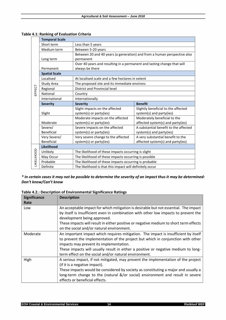
4.4 Assessment methodology To ensure a direct comparison between various specialist studies, a standard rating scale has been defined and will be used to assess and quantify the identified impacts. This is necessary since impacts have a number of parameters that need to be assessed. Five factors need to be considered when assessing the significance of impacts, namely: 1. Relationship of the impact to temporal scales - the temporal scale defines the significance of the impact
at various time scales, as an indication of the duration of the impact. 2. Relationship of the impact to spatial scales - the spatial scale defines the physical extent of the impact. 3. The severity of the impact - the severity/beneficial scale is used in order to scientifically evaluate how
severe negative impacts would be, or how beneficial positive impacts would be on a particular affected system (for ecological impacts) or a particular affected party.
4. The severity of impacts can be evaluated with and without mitigation in order to demonstrate how serious the impact is when nothing is done about it. The word ‘mitigation’ means not just ‘compensation’, but also the ideas of containment and remedy. For beneficial impacts, optimization means anything that can enhance the benefits. However, mitigation or optimization must be practical, technically feasible and economically viable.
5. The likelihood of the impact occurring - the likelihood of impacts taking place as a result of project actions differs between potential impacts. There is no doubt that some impacts would occur (e.g. loss of vegetation), but other impacts are not as likely to occur (e.g. vehicle accident), and may or may not result from the proposed development. Although some impacts may have a severe effect, the likelihood of them occurring may affect their overall significance.
Each criterion is ranked with scores assigned as presented in Table 4.1 to determine the overall significance of an activity. The criterion is then considered in two categories, viz. effect of the activity and the likelihood of the impact. The total scores recorded for the effect and likelihood are then read off the matrix presented in Table 4.1, to determine the overall significance of the impact. The overall significance is either negative or positive.
Agricultural & Soil Assessment – June 2018
EOH Coastal & Environmental Services 14 Rietkloof WEF
Table 4.1: Ranking of Evaluation Criteria
EF
FE
CT
Temporal Scale
Short term Less than 5 years
Medium term Between 5-20 years
Long term Between 20 and 40 years (a generation) and from a human perspective also permanent
Permanent Over 40 years and resulting in a permanent and lasting change that will always be there
Spatial Scale
Localised At localised scale and a few hectares in extent
Study Area The proposed site and its immediate environs
Regional District and Provincial level
National Country
International Internationally
Severity Severity Benefit
Slight Slight impacts on the affected system(s) or party(ies)
Slightly beneficial to the affected system(s) and party(ies)
Moderate Moderate impacts on the affected system(s) or party(ies)
Moderately beneficial to the affected system(s) and party(ies)
Severe/ Beneficial
Severe impacts on the affected system(s) or party(ies)
A substantial benefit to the affected system(s) and party(ies)
Very Severe/ Beneficial
Very severe change to the affected system(s) or party(ies)
A very substantial benefit to the affected system(s) and party(ies)
LIK
ELIH
OO
D Likelihood
Unlikely The likelihood of these impacts occurring is slight
May Occur The likelihood of these impacts occurring is possible
Probable The likelihood of these impacts occurring is probable
Definite The likelihood is that this impact will definitely occur
* In certain cases it may not be possible to determine the severity of an impact thus it may be determined: Don’t know/Can’t know Table 4.2.: Description of Environmental Significance Ratings
Significance Rate
Description
Low An acceptable impact for which mitigation is desirable but not essential. The impact by itself is insufficient even in combination with other low impacts to prevent the development being approved. These impacts will result in either positive or negative medium to short term effects on the social and/or natural environment.
Moderate An important impact which requires mitigation. The impact is insufficient by itself to prevent the implementation of the project but which in conjunction with other impacts may prevent its implementation. These impacts will usually result in either a positive or negative medium to long-term effect on the social and/or natural environment.
High A serious impact, if not mitigated, may prevent the implementation of the project (if it is a negative impact). These impacts would be considered by society as constituting a major and usually a long-term change to the (natural &/or social) environment and result in severe effects or beneficial effects.

Agricultural & Soil Assessment – June 2018
EOH Coastal & Environmental Services 15 Rietkloof WEF
Very High A very serious impact which, if negative, may be sufficient by itself to prevent implementation of the project. The impact may result in permanent change. Very often these impacts are unmitigable and usually result in very severe effects, or very beneficial effects.
The environmental significance scale is an attempt to evaluate the importance of a particular impact. This evaluation needs to be undertaken in the relevant context, as an impact can either be ecological or social, or both. The evaluation of the significance of an impact relies heavily on the values of the person making the judgment. For this reason, impacts of especially a social nature need to reflect the values of the affected society.
4.5 Sensitivity assessment This section of the report explains the approach to determining the agricultural sensitivity of the study area on a broad scale. The approach identifies zones of high, moderate and low sensitivity according to a system developed by EOH and used in numerous agricultural studies. It must be noted that the sensitivity zonings in this study are based solely on agricultural characteristics and social and economic factors have not been taken into consideration. The sensitivity analysis described here is based on 6 criteria which are considered to be of importance in determining agricultural sensitivity. The method predominantly involves identifying agricultural use, topography and land use (Table 4.3). Although very simple, this method of analysis provides a good, yet conservative and precautionary assessment of the agricultural sensitivity. Table 4.3: Criteria used for the analysis of the agricultural sensitivity of the area.
CRITERIA LOW SENSITIVITY MODERATE SENSITIVITY HIGH SENSITIVITY
1 Topography – Lay of the land
Level or even Undulating; fairly steep slopes Complex and uneven with steep slopes
2 Soil – Suitability of soils for crops
Low suitability (shallow soils, low/high pH, etc.)
Moderate suitability (area limited, input required, etc.)
Optimal soils
3 Land use – Current use of the land
Non-agricultural use, Natural veld (no grazing & browsing), urban areas etc.
Minimal agricultural use All farmland
4 Agricultural use - leading to loss of viable land
No agricultural practices
Subsistence and informal farming (occasional farming)
Commercial farming & irrigation
5 Erosion potential or instability of the region
Very stable and an area not subjected to erosion
Some possibility of erosion or change due to episodic events
Large possibility of erosion, change to the site or destruction due to climatic or other factors
6 Water use – Availability of surface water for agricultural use
No surface water onsite
NA Surface water onsite
A sensitivity map was drawn up with the aid of a satellite image so that the sensitive regions and agricultural types could be plotted (see Section 8).

Agricultural & Soil Assessment – June 2018
EOH Coastal & Environmental Services 16 Rietkloof WEF
5 RELEVANT LEGISLATION The following legislation and other regulatory instruments are directly relevant when considering impacts on the existing soil and agricultural uses identified for the Rietkloof WEF project. Table 5.1: Legislation and other regulatory instruments considered in the preparation of the Rietkloof WEF Soil and Agricultural Report.
Title of relevant legislation, policy or
guideline Date Implications for proposed Rietkloof WEF project
The National Environmental Management Act (NEMA) (107 of 1998)
1998 The developer must apply the NEMA principles, the fair decision-making and conflict management procedures that are provided for in NEMA. The developer must apply the principles of Integrated Environmental Management and the consideration, investigation and assessment of the potential impact of existing and planned activities on the environment, socio-economic conditions; and the cultural heritage.
National Environmental Management Biodiversity Act (NEMBA)(No. 10 of 2004); Aliens & Invasive Species (AIS) Regulations
2004 Lists invasive species that are:
Restricted activities and are prohibited in terms of Section 71A(1)
Exempted in terms of Section 71(3)
Require a permit in terms of Section 71(1)
Conservation of Agricultural Resources Act (CARA)(No. 43 of 1983)
1983 The Act deals with the conservation of natural agricultural resources;
Must assess the impacts of the proposed development on the existing agricultural environment;
Must maintain the production potential of the land by:- o Combating and preventing erosion; o Preventing the weakening or destruction of water
sources; o Protecting vegetation; o Combating weeds and invader plants. o Cultivation of virgin soil. o Protection of cultivated land. o Utilisation and protection of the veld. o Control of weed and invader plants. o Prevention and control of veld fires and the
restoration and reclamation of eroded land.
National Water Act (No. 36 of 1998)
1998 Provides details of measures intended to ensure the comprehensive protection of all water resources, including the ecological reserve (quantity and quality) for surface and underground water.
The Subdivision of Agricultural Land Act (No. 70 of 1970)
1970 This Act controls the subdivision of all agricultural land in South Africa and prohibits certain actions relating to agricultural land. In terms of the Act, the owner of agricultural land is required to obtain consent from the Minister of Agriculture in order to subdivide agricultural land. The purpose of the Act is to prevent uneconomic farming units from being created and degradation of prime agricultural land. The Act also regulates leasing and selling of agricultural land as well as registration of servitudes.

Agricultural & Soil Assessment – June 2018
EOH Coastal & Environmental Services 17 Rietkloof WEF
6 BASELINE DESCRIPTION
In terms of Appendix 6 of the EIA Regulations (2014) a specialist report must contain-
(f) the specific identified sensitivity of the site related to the activity and its associated structures and infrastructure;
This section provides a brief of the current state of the natural environment of the proposed Rietkloof WEF project.
6.1 Climate Laingsburg, the closest town to the Rietkloof WEF site, normally receives about 61mm of rain per year, with most rainfall occurring during mid-summer. On average, Laingsburg receives its lowest annual rainfall (0mm) in December and the highest (9mm) in March. The average midday temperatures for Laingsburg ranges from 16.6°C in July to 30.1°C in January. The region is the coldest during July when the temperature drops to 2.9°C on average during the night.
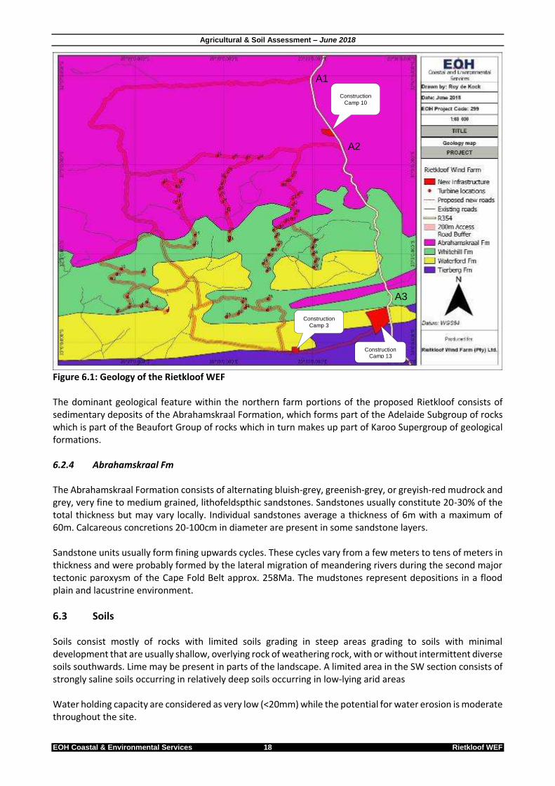
6.2 Geology The entire Rietkloof WEF consists of sedimentary rocks of the Karoo Supergroup. Stratigraphy ranges from older Ecca Group of rocks in the south to more recent Beaufort Group deposits in the northern sections. The Permian-aged Ecca sediments reflect lateral facies changes that characterise this succession. Lithotsratigraphically, Ecca rocks within the study site consists of:
Whitehill Formation (Fm)(Lower Ecca)
Tierberg Fm (Upper Ecca)
Waterford Fm (Upper Ecca) 6.2.1 Whitehill Fm Mudrocks of this Fm weather white on the surface, making it a very useful marker unit. In fresh outcrop and in the subsurface, the predominant facies is black, carboniferous, pyrite-bearing shale. The shale is very thinly laminated and contains up to 14% carboniferous material (du Toit, 1954). The thickness varies from 10 to 80m and contains the fossilised reptile Mesosaurus. 6.2.2 Tierberg Fm The Tierberg Fm is predominantly an argillaceous succession which reaches a maximum thickness of approximately 700m. It rests with a sharp contact on the Whitehill Fm and grades upwards into the arenaceous Waterford Fm. Rocks comprise well-laminated, dark grey to black shale. Calcareous concresions are common with clastic rhythmites occurring at various levels in the sequence. 6.2.3 Waterford Fm The major rock types found are fine-to medium-brained sandstone, siltstone, shale, and rhythmite in a succession with a mean thickness of 130m. The Fm displays an overall coarsening upward pattern, grading from the argillaceous underlying Tierberg Fm through alternating sandstone, siltstone and mudstone into a sandstone-dominated interval at the top.
Agricultural & Soil Assessment – June 2018
EOH Coastal & Environmental Services 18 Rietkloof WEF
Figure 6.1: Geology of the Rietkloof WEF The dominant geological feature within the northern farm portions of the proposed Rietkloof consists of sedimentary deposits of the Abrahamskraal Formation, which forms part of the Adelaide Subgroup of rocks which is part of the Beaufort Group of rocks which in turn makes up part of Karoo Supergroup of geological formations. 6.2.4 Abrahamskraal Fm The Abrahamskraal Formation consists of alternating bluish-grey, greenish-grey, or greyish-red mudrock and grey, very fine to medium grained, lithofeldspthic sandstones. Sandstones usually constitute 20-30% of the total thickness but may vary locally. Individual sandstones average a thickness of 6m with a maximum of 60m. Calcareous concretions 20-100cm in diameter are present in some sandstone layers. Sandstone units usually form fining upwards cycles. These cycles vary from a few meters to tens of meters in thickness and were probably formed by the lateral migration of meandering rivers during the second major tectonic paroxysm of the Cape Fold Belt approx. 258Ma. The mudstones represent depositions in a flood plain and lacustrine environment.
6.3 Soils Soils consist mostly of rocks with limited soils grading in steep areas grading to soils with minimal development that are usually shallow, overlying rock of weathering rock, with or without intermittent diverse soils southwards. Lime may be present in parts of the landscape. A limited area in the SW section consists of strongly saline soils occurring in relatively deep soils occurring in low-lying arid areas Water holding capacity are considered as very low (<20mm) while the potential for water erosion is moderate throughout the site.
Construction
Camp 10
Construction
Camp 3
Construction Camp 13
A1
A2
A3
Agricultural & Soil Assessment – June 2018
EOH Coastal & Environmental Services 19 Rietkloof WEF
Below is a table of generalised soil status for the Rietkloof WEF. This information will be compared to the laboratory analysis of soil samples collected onsite during the site visit (Section 7). Table 6.1: Generalised soil status for the Rietkloof WEF (Source: www.agis.agric.za)
Soil condition Classification
Potential for soil regeneration Very low potential
Natural soil organic carbon content <5 % C
pH 7.5 – 8.4 (alkaline)
Acidification Not susceptible to acidification
Cation exchange capacity 6.1 – 10 cmolc.kg-1 of soil
Soil zinc status 6.1 mg.kg-1
Soil copper status 1 – 2 mg.kg-1
Soil cobalt status 2 – 10 mg.kg-1
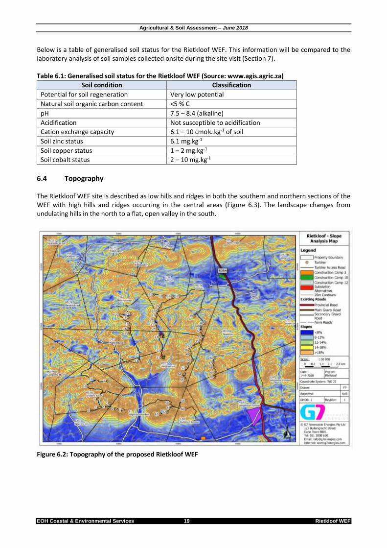
6.4 Topography The Rietkloof WEF site is described as low hills and ridges in both the southern and northern sections of the WEF with high hills and ridges occurring in the central areas (Figure 6.3). The landscape changes from undulating hills in the north to a flat, open valley in the south.
Figure 6.2: Topography of the proposed Rietkloof WEF

Agricultural & Soil Assessment – June 2018
EOH Coastal & Environmental Services 20 Rietkloof WEF
6.5 Vegetation Mucina and Rutherford (2006) define the following vegetation types that occur within the Rietkloof WEF site and associate infrastructure and from which source these descriptions are derived: 6.5.1 Central Mountain Shale Renosterveld This vegetation type forms part of the Fynbos Biome and is found in both the Western and Northern Cape Provinces. Its range extend from the southern and south-eastern slopes of the Klein-Roggeveldberge and Komsberg below the Roggeveld section of the Great Escarpment (facing the Moordenaars Karoo) as well as farther east below Besemgoedberg and Suurkop west of Merweville and in the west in the Karookop area between Losper-se-Berg and high points around Thyshoogte. All wind farm infrastructure will be located on this vegetation type. The site is dominated by renosterbos and large suites of mainly non-succulent Karoo scrubs with a rich geophytic flora in the undergrowth in more open, wetter or rocky habitats. SANBI classified this vegetation type as Least Threatened although none is conserved in statutory or private conservation areas while only about 1% is currently transformed. 6.5.2 Koedoesberge-Moordenaars Karoo This vegetation type forms part of the Succulent Karoo Biome and occurs in the Western and Northern Cape Provinces. Koedoesberge-Moordenaars Karoo occurs in the broader Laingsburg and Merweville area between the Koedoesberge and Pienaar-se-Berg low mountain ranges and the southern Tankwa Karoo. It is separated by the Moordenaars Karoo by the Klein Roggeveld Mountains. The unit also includes the Doesberg region east of Laingsburg as well as the piedmonts of the Elandsberg and beyond the Gamkapoort Dam at Excelsior (west of Prince Albert). This vegetation unit occurs on slightly undulating to hilly landscapes that is covered by low succulent scrub and dotted by scattered tall scrubs. Patched of lighter coloured grasses are visible on the plains with Pteronia, Drosanthemums and Galenia spp. being most dominant. This vegetation unit is classified as Least Threatened although only a small portion is conserved in the Gankapoort Nature Reserve with only a small portion considered as transformed. No wind farm infrastructure will be located on Koedoesberge-Moordenaars Karoo. 6.5.3 Tanqua Wash Riviere This vegetation type is classified by Mucina & Rutherford (2006) as Inland Azonal Saline Vegetation and is associated with “salty areas” (areas containing high salt content in soil and water) not influenced by the sea. The salinity originates either from salt-bearing substrate or from mineral-rich groundwater sources. Tanqua Wash Riviere occurs on deeply incised valleys (sometimes several hundred meters broad) of intermittent rivers supporting a mosaic of succulent shrubland containing Salsola and Lyceum alternating with Acacia karroo gallery thickets. The broad sheet-wash plains support sparse vegetation of various Salsola spp., often building phytogenic hillocks interrupting the monotonous barren face of a sheet wash. Occasional rainfalls in early winter result in localised displays of annuals and early flowering geophytes along these washes. This vegetation unit is classified as Least Threatened, but only 13% is statutory conserved in the Tankwa National Park and other private reserves. Only about 3% are currently transformed for cultivation of dam building. Aliens like Atriplex lindleyi and Prosopis spp. can become frequent in places.

Agricultural & Soil Assessment – June 2018
EOH Coastal & Environmental Services 21 Rietkloof WEF
Figure 6.5: Vegetation map of the Rietkloof WEF area
6.6 Surface hydrology Surface hydrology refers to all surface waters found onsite and includes overland flows, rivers, lakes, wetlands, estuaries and oceans, excluding atmospheric and groundwater. 6.6.1 Rivers, streams and drainage systems Various systems will be impacted by the proposed Rietkloof WEF development (Figure 6.6). Various access roads transect streams and drainage systems at various points within the proposed site. Most of these crossings are existing. This will however be confirmed by the aquatic specialist. 6.6.2 Wetlands No turbine sites will be located within 500m of any priority wetland or artificial farm or irrigation dam. Some access roads however does transect dry Karoo wetland systems as defined by the National Freshwater Ecosystem Priority Area (NFEPA) and will require authorisation from the Department of Water & Sanitation (DWS). Construction camp alternative 10 is located in close proximity to the NFEPA identified wetlands, but aerial imagery shows that these wetlands have been extensively developed for irrigation of agricultural cash crops (Figure 6.7). This will however be confirmed by the aquatic specialist.
Construction
Camp 10
Construction Camp 3
Construction Camp 13
A1
A2
A3

Agricultural & Soil Assessment – June 2018
EOH Coastal & Environmental Services 22 Rietkloof WEF
Figure 6.6: Surface water map of the Rietkloof WEF area
NFEPA overlay shows surface water (rivers & wetlands) in close proximity to the substation site alternative.
Aerial imagery shows a river with irrigation in the floodplain in close proximity to the substation site alternative.
Figure 6.7: Infrastructure located close to or within water bodies.
6.7 Current land use Land uses in the landscape within and adjacent to the proposed Rietkloof WEF include: Agricultural land uses in the landscape within and adjacent to the proposed Rietkloof Wind Farm includes:
Rural agriculture consisting of extensive small stock grazing (Dorper and Dohne Merino)
Hunting
N N
Construction Camp 10
Construction Camp 3
Construction Camp 13
A1
A2
A3
Construction Camp 10 Construction
Camp 10

Agricultural & Soil Assessment – June 2018
EOH Coastal & Environmental Services 23 Rietkloof WEF
Concentrated irrigation for various cash crops is practised along rivers and streams in small areas. Although various farmsteads are located on the site, none will be impacted by the proposed Rietkloof Wind Farm infrastructure. Various existing farm roads exists onsite and are in good condition (good surface with little or no erosion). Some of these roads will be upgraded to accommodate construction vehicles as well as the large trucks transporting turbine components. The natural veld is considered to be in good condition with little or no evidence of erosion and overgrazing. 6.7.1 Livestock Agricultural practices in the area consist mainly of small stock farming (Dorper and Dohne Merino sheep). Small amounts of wool are also produced. No other livestock were observed. Rangeland within the Rietkloof Wind Farm area requires low input costs and are located of large area farms (2000-3000 ha) with low population density, resulting in productive livestock farming, mostly with sheep. Although goats and cattle are also viable options, they were not observed in any of the affected farms. Rotational grazing camps are practised allowing grazed land to “rest” for periods of time. As rangelands are vast with low carrying capacity, developing a Wind Farm in the area will have minimal impact on livestock farming. 6.7.2 Hunting Game is now also considered to be an agricultural product as defined in the Marketing of Agricultural Products Act, 1996 (Act 47 of 1996). Game ranching (and hunting) in South Africa is one of the fastest-growing sectors of the agricultural industry. Since the 1970’s, there has been a huge shift from cattle & sheep farming to game ranching. Provided they observe approved game-fencing rules, registered game ranches have permission to hunt throughout the year. Lange game occurring within all the Rietkloof Wind Farm site includes:
Kudu (not observed)
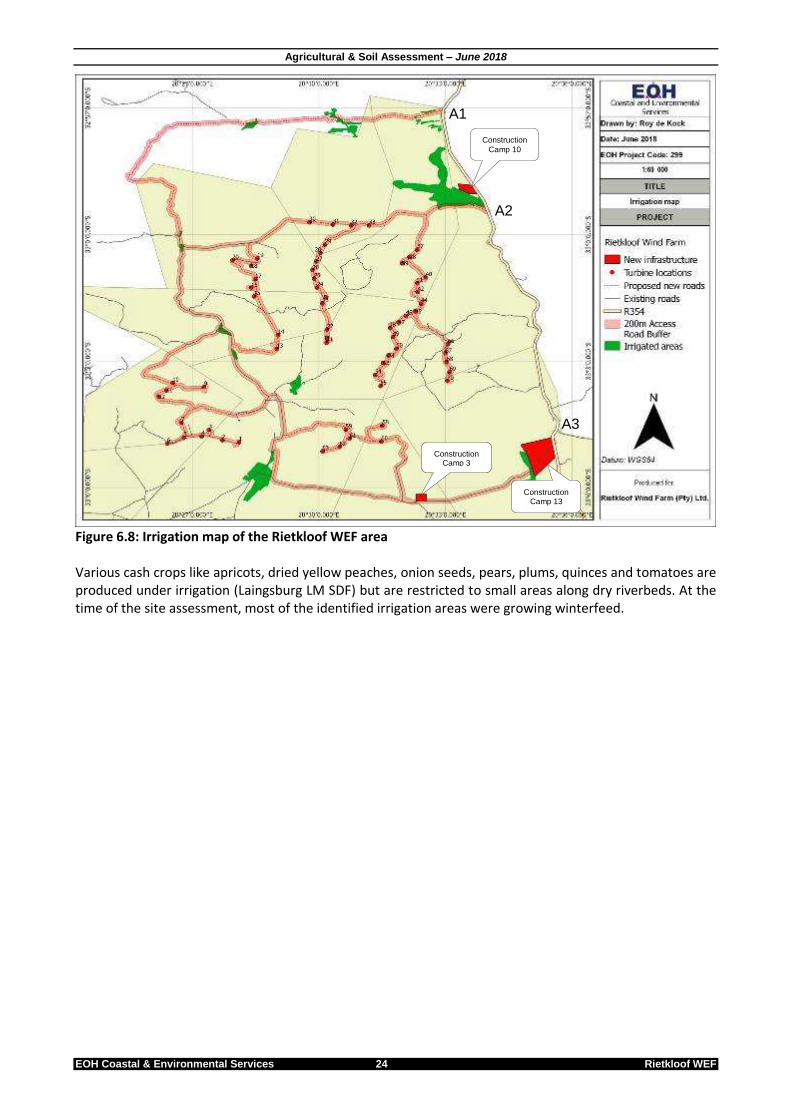
Springbok Recreational hunting occurs on all Rietkloof properties. As game is scattered over large areas, construction and operation of the proposed new Rietkloof Wind Farm will not impact on hunting in the area. 6.7.3 Irrigation & crops As the area only receives about 61mm of rainfall per year, dryland cropping is not viable. Irrigation is intensively practiced in areas along dry riverbeds where irrigation dams can be erected, and soils are suitable (Figure 6.8). Approximately 5% of all the farm areas affected by the proposed Rietkloof Wind Farm is currently under irrigation.
Agricultural & Soil Assessment – June 2018
EOH Coastal & Environmental Services 24 Rietkloof WEF
Figure 6.8: Irrigation map of the Rietkloof WEF area Various cash crops like apricots, dried yellow peaches, onion seeds, pears, plums, quinces and tomatoes are produced under irrigation (Laingsburg LM SDF) but are restricted to small areas along dry riverbeds. At the time of the site assessment, most of the identified irrigation areas were growing winterfeed.
Construction
Camp 10
Construction Camp 3
Construction Camp 13
A1
A2
A3
Agricultural & Soil Assessment – June 2018
EOH Coastal & Environmental Services 25 Rietkloof WEF
7 SOILS This section presents the procedure to describe the different morphological and other characteristics of soils found within the Rietkloof WEF site. Five random points (shown in Figure 7.1 and Table 7.1) were identified within the WEF area. These site selections were based on accessibility to the site. Soil samples were collected from each of these sites for laboratory assessment while the sites were visually assessed. The following procedure was followed during the field assessment: 1. Soil families were identified as per the Soil Classification workbook, 1991. 2. The master horizons present in the profile were demarcated. 3. Diagnostic horizons or materials were identified. 4. The texture class of the A horizons were determined and added to the name or code of the soil family as
per the Soil Classification workbook, 1991. Table 7.1: Coordinated of the 5 x soil sample sites
Site # GPS coordinates
Latitude Longitude
S1 33° 5'31.21"S 20°35'41.20"E
S2 33° 5'43.47"S 20°33'15.27"E
S3 33° 5'59.41"S 20°28'3.48"E
S4 33° 6'36.08"S 20°25'6.63"E
S5 33° 1'19.05"S 20°34'46.01"E
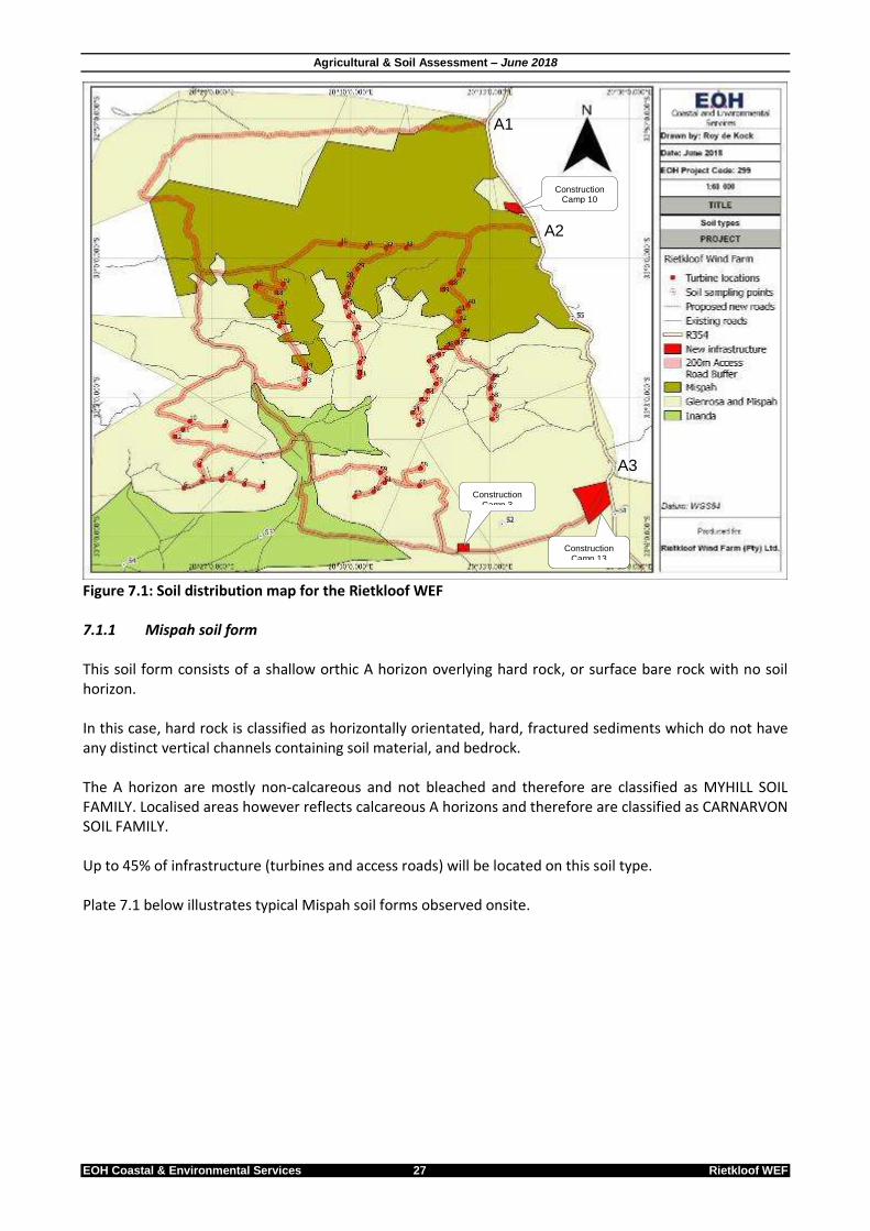
7.1 Soil classification Based on a visual survey conducted during the site visit (Table 7.2) as well as soil samples collected from each area that was visually classified, the dominant soil forms (as per the Soil Classification workbook, 1991) were identified within the Rietkloof WEF site (Figure 7.2) as:
Mispah soil form
Glenrosa soil form
Inanda soil form It has been calculated that the total final permanent footprint for the Rietkloof Wind Farm will be approx. 126ha. The bulk of infrastructure (approx. 90%) will be located on Mispah and Glenrosa soils (half each). The remainder will be located on Inanda soils. Table 7.2: Visual description of the 5 sites sampled within the Rietkloof WEF
Sample # Photo Description
1
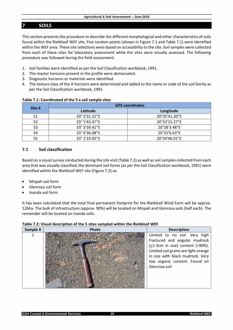
Limited to no soil. Very high fractured and angular mudrock (+1-3cm in size) content (>90%). Limited soil grains are light orange in size with black mudrock. Very low organic content. Found on Glenrosa soil
Agricultural & Soil Assessment – June 2018
EOH Coastal & Environmental Services 26 Rietkloof WEF
Sample # Photo Description
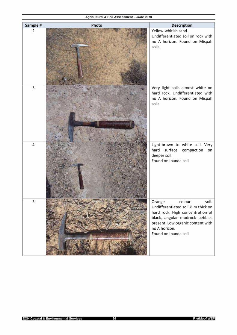
2
Yellow-whitish sand. Undifferentiated soil on rock with no A horizon. Found on Mispah soils
3
Very light soils almost white on hard rock. Undifferentiated with no A horizon. Found on Mispah soils
4
Light-brown to white soil. Very hard surface compaction on deeper soil. Found on Inanda soil
5
Orange colour soil. Undifferentiated soil ½ m thick on hard rock. High concentration of black, angular mudrock pebbles present. Low organic content with no A horizon. Found on Inanda soil
Agricultural & Soil Assessment – June 2018
EOH Coastal & Environmental Services 27 Rietkloof WEF
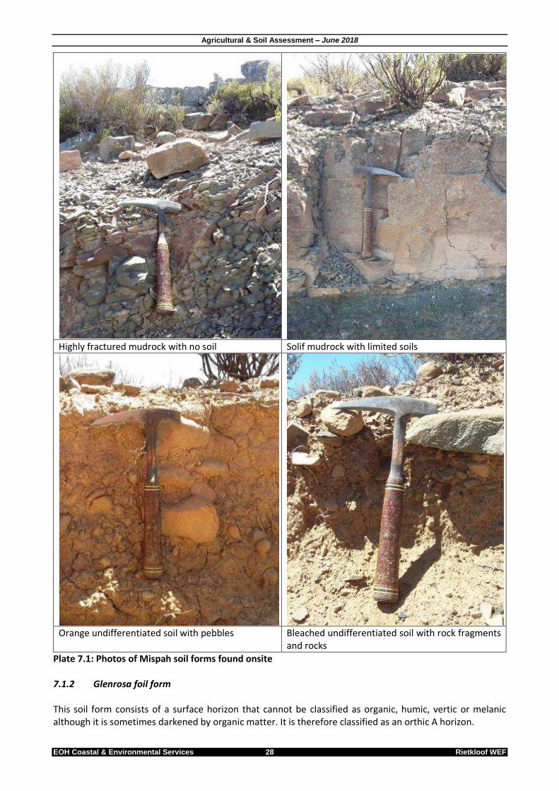
Figure 7.1: Soil distribution map for the Rietkloof WEF 7.1.1 Mispah soil form This soil form consists of a shallow orthic A horizon overlying hard rock, or surface bare rock with no soil horizon. In this case, hard rock is classified as horizontally orientated, hard, fractured sediments which do not have any distinct vertical channels containing soil material, and bedrock. The A horizon are mostly non-calcareous and not bleached and therefore are classified as MYHILL SOIL FAMILY. Localised areas however reflects calcareous A horizons and therefore are classified as CARNARVON SOIL FAMILY. Up to 45% of infrastructure (turbines and access roads) will be located on this soil type. Plate 7.1 below illustrates typical Mispah soil forms observed onsite.
Construction Camp 10
ConstructionCamp 3
Construction Camp 13
A1
A2
A3
Agricultural & Soil Assessment – June 2018
EOH Coastal & Environmental Services 28 Rietkloof WEF
Highly fractured mudrock with no soil Solif mudrock with limited soils
Orange undifferentiated soil with pebbles Bleached undifferentiated soil with rock fragments
and rocks
Plate 7.1: Photos of Mispah soil forms found onsite 7.1.2 Glenrosa foil form This soil form consists of a surface horizon that cannot be classified as organic, humic, vertic or melanic although it is sometimes darkened by organic matter. It is therefore classified as an orthic A horizon.

Agricultural & Soil Assessment – June 2018
EOH Coastal & Environmental Services 29 Rietkloof WEF
Subsoil directly underlies the orthic A horizon and merges into the underlying rock. This layer consists mostly of fresh or weathered parent rock and therefore is classified as a lithocutanic B horizon. The A horizon are bleached most of the time while the B horizon are hard, non-calcareous with no sign of wetness, and therefore are classified as BERGSIG SOIL FAMILY. Up to 45% of infrastructure (turbines and access roads) will be located on this soil type. Plate 7.2 below illustrates typical Glenrosa soil form observed onsite.
Bleached soils with a well-defined plant root layer over a meter thick.
Redish-orange soil up to 90cm thick.
Plate 7.2: Photos of Glenrosa soil forms found onsite 7.1.3 Inanda soil form This soil for has a distinct humic A horizon of various thickness overlying a red apedal B horizon. This soil type has a high salt content and is usually brackish because this. Known as saline soil, it can cause damage to and stall plant growth, impede germination, and cause difficulties in irrigation. The salinity is due to the build-up of soluble salts in the rhizosphere—high salt contents prevent water uptake by plants, leading to drought stress. The humic A horizon is usually thin with a non-luvic B1 horison and therefore are classified as HIMEVILLE SOIL FAMILY. Approximately 10% of Rietkloof WEF infrastructure will be located on this soil type.
Agricultural & Soil Assessment – June 2018
EOH Coastal & Environmental Services 30 Rietkloof WEF
7.2 Suitability for agriculture 7.2.1 Mispah form Cropping: due to limited soil profiles, Mispah soils are not suitable for dryland cropping or irrigation. Natural veld: Mispah soils accommodate a limited variety of vegetation and only range between Karoo scrub and succulent vegetation. Although small stock farming (Dorper and Dohne Merino sheep) are practised, grazing capacity is considered as low (26-30 ha/Animal Unit according to AGIS). Water capacity: Due to the low rainfall soils contribute to hydrology only by overland flow and evapotranspiration. 7.2.2 Glenrosa form Cropping: due to limited water availability, Glenrosa soils are not suitable for dryland cropping. Irrigation of cash crops is only possible along riverbeds, provided that irrigation dams are constructed to aid water availability. Less than 10% of the Rietkloof WEF site is suitable for this. Natural veld: Glenrosa soils accommodate a variety of vegetation ranging from a variety of scrublands, savannah and succulents. Small stock farming (Dorper and Dohne Merino sheep) are practised, grazing capacity is considered as low to moderate (18-25 ha/Animal Unit according to AGIS). Water capacity: Due to the low rainfall soils contribute to hydrology only by overland flow and evapotranspiration. 7.2.3 Inanda form Cropping: Under optimal conditions (e.g. water availability), pH correction etc. this soil type can be used for crops Natural veld: Inanda soils accommodate sparse vegetation consisting predominantly of Salsola and Lyceum spp. interspersed with schrubland in drainage systems and valleys. Although small stock farming (Dorper and Dohne Merino sheep) are practised, grazing capacity is considered as low (26-30 ha/Animal Unit according to AGIS). Water capacity: Due to the low rainfall soils contribute to hydrology only by overland flow and evapotranspiration. 7.2.4 Agricultural potential Agricultural potential in the Rietkloof WEF area is classified according to the land potential classification system of the Department of Agriculture (part of the Department of Agriculture, Forestry and Fisheries). This classification system takes factors such as climate, soil and slope into consideration to determine agricultural potential. Although it provides only a macro perception of the agricultural potential in the region, it is still a fair indication of what the broader agricultural potential of the area is. DAFF (Agriculture) has classified the Rietkloof WEF area into the following agricultural potential classes:
Non-arable land with a low potential for grazing
Land capability classification class 7 and 8 only
Land unsuitable for crops unless under irrigation.

Agricultural & Soil Assessment – June 2018
EOH Coastal & Environmental Services 31 Rietkloof WEF
Based on the agricultural potential onsite, DAFF (Agriculture) has determined the grazing capacity to be between 18-25 hectare per large stock unit (ha/LSU) on low undulating landscapes and 26-30 ha/LSU on steep mountainous areas. Grazing capacity potential was determined in 1995 by DAFF (Agriculture) to be:
Between 41-80 ha/LSU increasing to 26-30 ha/LSU towards the eastern sections. This indicates that, grazing onsite is not utilised to its fullest potential capacity, but this is as a result of water availability. The area is currently also in a drought cycle.
7.3 Laboratory results Soil samples S1 & S2 (See Figure 7.1) were collected on Glenrosa soil form which contains a hard orthic A horizon occurring on a fine lithocutanic B horizon while soil samples S3 & S4 were collected from a deeper humic A horizon overlying a red apedal B horizon of varying depth (called Inanda soil form). Soil sample S5 was collected on soils overlying hard rock (Mispah soil form). All soils within the Rietkloof WEF site occurs on sand with a low organic content (When only considering S1-3). Soils to the west of the site (S4) have higher TEC reflecting clay & clay loams. Table 7.4 summarises average conditions of soils found onsite: Table 7.4: Average soil conditions within the Rietkloof WEF site
Measured condition Glenrosa Soils Inanda Soils Mispah Soils
pH 7.8 8 6.6
Organic content 1.1% 0.97 1.5
Ca 62.77% 59.87 25.74
Mg 27.53% 30.55 25.74
K 3.59% 4.08 4.3
Na 2.49% 2.08 2.05
Soil pH is considered as optimum between 6.5 and 7 for the highest plant nutrient availability for most crops. Mispah soils falls within this range while Glenrosa & Inanda soils are more alkaline, and are not suitable for most crops. 7.3.1 Glenrosa soils Calcium (Ca), Potassium (K) and Sodium (Na) all fall within the optimal rate for fertile soils (60-75% for Ca, 3-5% for K and 0.5-5% for Na), while magnesium (Mg) content is considered to high (10-20%). 7.3.2 Inanda soils Potassium (K) and Sodium (Na) all fall within the optimal rate for fertile soils (3-5% for K and 0.5-5% for Na), while magnesium (Mg) content is considered to high (10-20%) and Calcium (Ca) slightly low (60-75% for Ca). 7.3.3 Mispah soils Potassium (K) and Sodium (Na) all fall within the optimal rate for fertile soils (3-5% for K and 0.5-5% for Na), while magnesium (Mg) content is considered to high (10-20%) and Calcium (Ca) to low (60-75% for Ca).

Agricultural & Soil Assessment – June 2018
EOH Coastal & Environmental Services 32 Rietkloof WEF
7.3.4 Conclusion on agricultural suitability Based on these levels, soils within the Rietkloof WEF may be considered as optimum for a wide variety of crops under some soil management (pH, Mg & Ca corrections). The limiting factor onsite however is water availability (for all soil types) and soil depth (especially for Mispah soils) and as such crops can only be grown under irrigation in deeper alluviums next to river systems. Based on this, soils at the Rietkloof WEF is not considered as optimal for crop based agricultural activities.

Agricultural & Soil Assessment – June 2018
EOH Coastal & Environmental Services 33 Rietkloof WEF
8 SENSITIVITY ASSESSMENT
In terms of Appendix 6 of the EIA Regulations (2014) a specialist report must contain-
(g) an identification of any areas to be avoided, including buffers; (h) a map superimposing the activity including the associated structures and infrastructure on the
environmental sensitivities of the site including areas to be avoided, including buffers;
A sensitivity map was developed based on the allocations made in Section 4.5, for the Rietkloof Wind farm (Figure 8.1). The following sensitive areas were identified:
Area type Sensitivity allocation
Crop areas under irrigation High
Water bodies High
Drainage systems High
Shallow soils on sloped areas Moderate
Figure 8.1: Agricultural sensitivity map of the Rietkloof Wind farm area High sensitive areas are mostly avoided by Rietkloof infrastructure except where existing and new roads within these high sensitive area will be used for the Rietkloof wind farm. These high sensitive area are not considered as fatal flaws and if these roads cannot be moved and provided that the mitigations proposed in this assessment is implemented for these areas, development in these areas are supported. Grazing around the infrastructure can continue and therefore the current layout placed within areas considered to be of low and moderate sensitivity are fully supported.
Construction Camp 10
Construction Camp 3
Construction Camp 13
A1
A2
A3

Agricultural & Soil Assessment – June 2018
EOH Coastal & Environmental Services 34 Rietkloof WEF
9 IMPACT IDENTIFICATION AND ASSESSMENT
In terms of Appendix 6 of the EIA Regulations (2014) a specialist report must contain- (j) a description of the findings and potential implications of such findings on the impact of the
proposed activity, including identified alternatives on the environment; (k) any mitigation measures for inclusion in the EMPr;
9.1 Introduction This chapter details the potential soils and agricultural impacts identified. For each issue identified, details are provided, followed by the mitigation measures required to minimise the negative impacts associated with the issue.
9.2 Impacts on soils and agriculture Impacts on the agricultural potential of the affected land were identified during the Planning & Design, Construction, Operational and Decommissioning Phase of the proposed Rietkloof WEF project and are described below (Table 9.1). These included the consideration of direct, indirect and cumulative impacts that may occur. Table 9.1: Impacts to soil and agriculture associated with different phases of the proposed Rietkloof Wind Farm
Development Phase Issue Nature of
Impact Description of Impact
Planning & Design (for all project
components and all alternatives)
Issue 1: Increase in erosion potential
Direct Indirect Cumulative (Negative impact)
During the planning and design phase inappropriate stormwater design may lead to an increase in surface soil erosion.
Issue 2: Increase in renewable energy development in the local area
Cumulative (Negative impact)
During the planning and design phase the increase in renewable energy development in the local area will result in a gradual reduction of available agricultural land over time.
Issue 3: Loss of agricultural land
Direct (Negative impact)
During the planning and design phase the development of access roads may result in the loss of irrigated agricultural crop land.
Issue 4: Impact on local soil types
Cumulative (Negative impact)
The planning and design of a new wind farm will result in the loss of local soil types.
Construction (for all project components and all alternatives)
Issue 5: Management of hazardous chemicals
Direct (Negative impact)
During the construction phase hazardous chemical spills and leakages could lead to soil contamination and a loss of fertile soils if not managed appropriately.
Issue 6: Increased risk of fires from construction activities
Direct Cumulative (Negative impact)
During construction phase fires originating from the construction site could lead to the loss of grazing and game.
Issue 7: Direct Indirect
During the construction phase incorrect stockpiling of soil could result in a decrease of

Agricultural & Soil Assessment – June 2018
EOH Coastal & Environmental Services 35 Rietkloof WEF
Development Phase Issue Nature of
Impact Description of Impact
Soil stockpiling management
Cumulative (Negative impact)
agricultural viability/potential.
Issue 8: Soil profile disturbance and resultant decrease in soil agricultural capability
Direct Cumulative (Negative impact)
During the construction phase excavations for the construction of the turbines and associated infrastructure will disturb the soil profile. If topsoil becomes buried, or subsoil rock, that is less suitable for root growth, remains at the surface, the agricultural suitability of the soil, that will become available for agriculture again after decommissioning of the WEF, will be reduced
Issue 9: Establishment of renewable energy infrastructure on agricultural land
Direct Cumulative (Negative impact)
During the construction phase the WEF infrastructure (permanent and temporary) will result in the loss of up to 126 ha of low agricultural land
Issue 10: Increase in erosion potential
Direct Indirect Cumulative (Negative impact)
During the construction phase the increase in impacted areas and hard surfaces will increase run-off and potentially lead to soil erosion
Issue 11: Loss of agricultural crop land
Direct (Negative impact)
During the construction phase the construction of access roads may result in the permanent loss of existing croplands
Operation (for all project components and all alternatives)
Issue 12: Increase in erosion potential
Direct Indirect Cumulative (Negative impact)
During the operational phase an increase in hard surfaces (hardstands and roads) will increase run-off and potentially lead to soil erosion.
Issue 13: Establishment of renewable energy infrastructure on agricultural land
Direct Cumulative (Negative impact)
During the operational phase the WEF infrastructure will result in the loss of up to 126 ha of low agricultural land
Issue 14: Establishment of new access roads
Direct Indirect Cumulative (Positive impact)
During the operational phase the new access roads will allow for an easier access to farm areas previously inaccessible or difficult to access.
Decommissioning (for all project components and all alternatives)
Issue 15: Decommissioning and removal of renewable energy infrastructure on agricultural land
Cumulative (Positive impact)
During the decommissioning phase the decrease in renewable energy development in the local area will result in an increase of available agricultural land.
No-Go option
Issue 16: Not constructing the WEF
Direct Cumulative (Positive impact)
Not constructing the WEF will have no impact of agricultural land.

Agricultural & Soil Assessment – June 2018
EOH Coastal & Environmental Services 36 Rietkloof WEF
9.3 Impact Assessment The impacts identified in Section 9.2 are assessed in terms of the criteria described in Section 4.4 and are summarised below.
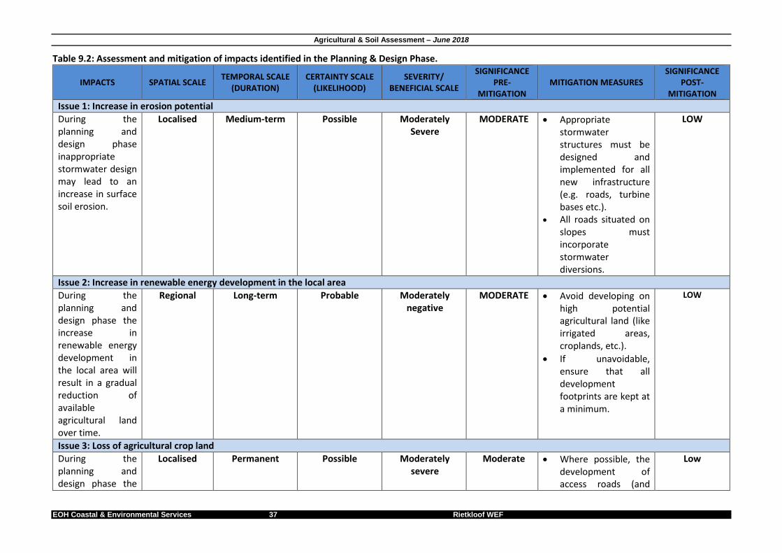
Agricultural & Soil Assessment – June 2018
EOH Coastal & Environmental Services 37 Rietkloof WEF
Table 9.2: Assessment and mitigation of impacts identified in the Planning & Design Phase.
IMPACTS SPATIAL SCALE TEMPORAL SCALE
(DURATION) CERTAINTY SCALE
(LIKELIHOOD) SEVERITY/
BENEFICIAL SCALE
SIGNIFICANCE PRE-
MITIGATION MITIGATION MEASURES
SIGNIFICANCE POST-
MITIGATION
Issue 1: Increase in erosion potential
During the planning and design phase inappropriate stormwater design may lead to an increase in surface soil erosion.
Localised Medium-term Possible Moderately Severe
MODERATE Appropriate stormwater structures must be designed and implemented for all new infrastructure (e.g. roads, turbine bases etc.).
All roads situated on slopes must incorporate stormwater diversions.
LOW
Issue 2: Increase in renewable energy development in the local area
During the planning and design phase the increase in renewable energy development in the local area will result in a gradual reduction of available agricultural land over time.
Regional Long-term Probable Moderately negative
MODERATE Avoid developing on high potential agricultural land (like irrigated areas, croplands, etc.).
If unavoidable, ensure that all development footprints are kept at a minimum.
LOW
Issue 3: Loss of agricultural crop land
During the planning and design phase the
Localised Permanent Possible Moderately severe
Moderate Where possible, the development of access roads (and
Low

Agricultural & Soil Assessment – June 2018
EOH Coastal & Environmental Services 38 Rietkloof WEF
IMPACTS SPATIAL SCALE TEMPORAL SCALE
(DURATION) CERTAINTY SCALE
(LIKELIHOOD) SEVERITY/
BENEFICIAL SCALE
SIGNIFICANCE PRE-
MITIGATION MITIGATION MEASURES
SIGNIFICANCE POST-
MITIGATION
development of access roads could result in the loss of irrigated agricultural crop land.
other infrastructure) must avoid impacting existing croplands.
If not possible, the loss of cropland must be offset by preparing a new cropland in close vicinity to the lost area.
Offset areas must be the same size as lost areas
Offset areas must be located in areas where both the landowner/occupier and the developer has agreed on prior to commencement of construction
Issue 4: Impact on local soil types
The planning and design of a new wind farm will result in the loss of local soil types.
Localised Permanent Definite Severe High Infrastructure must be planned in such a way as to minimise the loss of soil
High
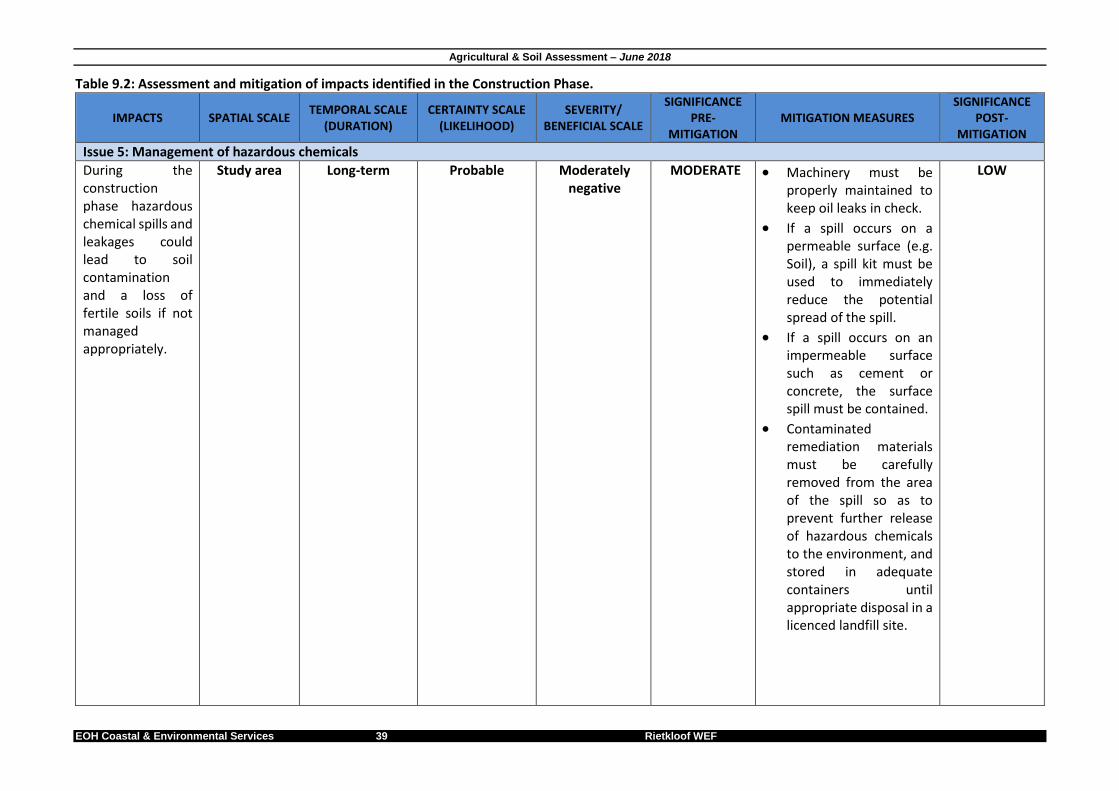
Agricultural & Soil Assessment – June 2018
EOH Coastal & Environmental Services 39 Rietkloof WEF
Table 9.2: Assessment and mitigation of impacts identified in the Construction Phase.
IMPACTS SPATIAL SCALE TEMPORAL SCALE
(DURATION) CERTAINTY SCALE
(LIKELIHOOD) SEVERITY/
BENEFICIAL SCALE
SIGNIFICANCE PRE-
MITIGATION MITIGATION MEASURES
SIGNIFICANCE POST-
MITIGATION
Issue 5: Management of hazardous chemicals
During the construction phase hazardous chemical spills and leakages could lead to soil contamination and a loss of fertile soils if not managed appropriately.
Study area Long-term Probable Moderately negative
MODERATE Machinery must be properly maintained to keep oil leaks in check.
If a spill occurs on a permeable surface (e.g. Soil), a spill kit must be used to immediately reduce the potential spread of the spill.
If a spill occurs on an impermeable surface such as cement or concrete, the surface spill must be contained.
Contaminated remediation materials must be carefully removed from the area of the spill so as to prevent further release of hazardous chemicals to the environment, and stored in adequate containers until appropriate disposal in a licenced landfill site.
LOW
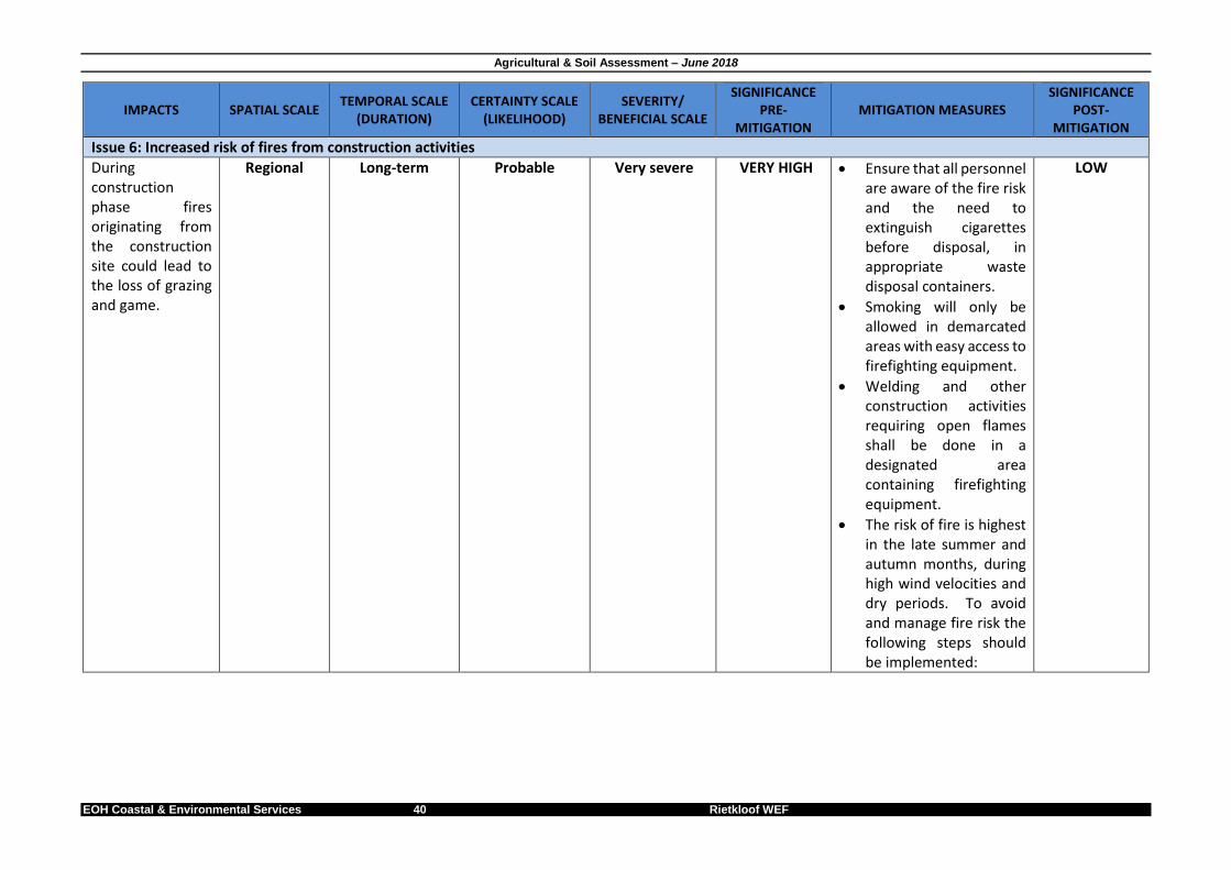
Agricultural & Soil Assessment – June 2018
EOH Coastal & Environmental Services 40 Rietkloof WEF
IMPACTS SPATIAL SCALE TEMPORAL SCALE
(DURATION) CERTAINTY SCALE
(LIKELIHOOD) SEVERITY/
BENEFICIAL SCALE
SIGNIFICANCE PRE-
MITIGATION MITIGATION MEASURES
SIGNIFICANCE POST-
MITIGATION
Issue 6: Increased risk of fires from construction activities
During construction phase fires originating from the construction site could lead to the loss of grazing and game.
Regional Long-term Probable Very severe VERY HIGH Ensure that all personnel are aware of the fire risk and the need to extinguish cigarettes before disposal, in appropriate waste disposal containers.
Smoking will only be allowed in demarcated areas with easy access to firefighting equipment.
Welding and other construction activities requiring open flames shall be done in a designated area containing firefighting equipment.
The risk of fire is highest in the late summer and autumn months, during high wind velocities and dry periods. To avoid and manage fire risk the following steps should be implemented:
LOW

Agricultural & Soil Assessment – June 2018
EOH Coastal & Environmental Services 41 Rietkloof WEF
IMPACTS SPATIAL SCALE TEMPORAL SCALE
(DURATION) CERTAINTY SCALE
(LIKELIHOOD) SEVERITY/
BENEFICIAL SCALE
SIGNIFICANCE PRE-
MITIGATION MITIGATION MEASURES
SIGNIFICANCE POST-
MITIGATION
o Have on site fire-fighting equipment and ensure that all personnel are educated how to use it and procedures to be followed in the event of a fire.
o Identify the relevant authorities and structures responsible for fighting fires in the area and shall liaise with them regarding procedures should a fire commence.
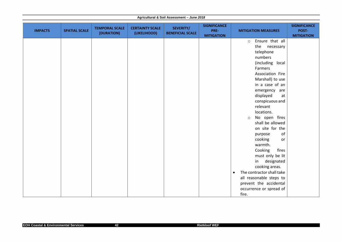
Agricultural & Soil Assessment – June 2018
EOH Coastal & Environmental Services 42 Rietkloof WEF
IMPACTS SPATIAL SCALE TEMPORAL SCALE
(DURATION) CERTAINTY SCALE
(LIKELIHOOD) SEVERITY/
BENEFICIAL SCALE
SIGNIFICANCE PRE-
MITIGATION MITIGATION MEASURES
SIGNIFICANCE POST-
MITIGATION
o Ensure that all the necessary telephone numbers (including local Farmers Association Fire Marshall) to use in a case of an emergency are displayed at conspicuous and relevant locations.
o No open fires shall be allowed on site for the purpose of cooking or warmth. Cooking fires must only be lit in designated cooking areas.
The contractor shall take all reasonable steps to prevent the accidental occurrence or spread of fire.
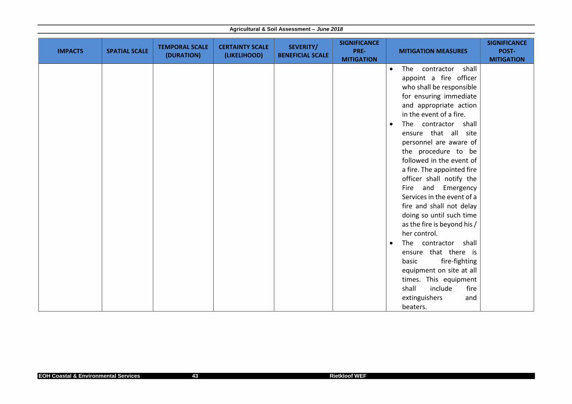
Agricultural & Soil Assessment – June 2018
EOH Coastal & Environmental Services 43 Rietkloof WEF
IMPACTS SPATIAL SCALE TEMPORAL SCALE
(DURATION) CERTAINTY SCALE
(LIKELIHOOD) SEVERITY/
BENEFICIAL SCALE
SIGNIFICANCE PRE-
MITIGATION MITIGATION MEASURES
SIGNIFICANCE POST-
MITIGATION
The contractor shall appoint a fire officer who shall be responsible for ensuring immediate and appropriate action in the event of a fire.
The contractor shall ensure that all site personnel are aware of the procedure to be followed in the event of a fire. The appointed fire officer shall notify the Fire and Emergency Services in the event of a fire and shall not delay doing so until such time as the fire is beyond his / her control.
The contractor shall ensure that there is basic fire-fighting equipment on site at all times. This equipment shall include fire extinguishers and beaters.

Agricultural & Soil Assessment – June 2018
EOH Coastal & Environmental Services 44 Rietkloof WEF
IMPACTS SPATIAL SCALE TEMPORAL SCALE
(DURATION) CERTAINTY SCALE
(LIKELIHOOD) SEVERITY/
BENEFICIAL SCALE
SIGNIFICANCE PRE-
MITIGATION MITIGATION MEASURES
SIGNIFICANCE POST-
MITIGATION
Any work that requires the use of fire may only take place within designated areas. Fire-fighting equipment shall be available in these areas.
Issue 7: Soil stockpiling management
During the construction phase incorrect stockpiling of soil could result in a decrease of agricultural viability/potential.
Localised Medium-term Probable Moderate MODERATE Develop and implement a Rehabilitation and Monitoring Plan to monitor rehabilitated areas.
Ensure that topsoil does not get buried by subsoil during stockpiling. Failure to comply may result in topsoil sterilisation.
Implement measures such as wind-breaks, swales and watering as required aiding the initial grown of primary vegetation.
Fertile topsoil must not be stockpiled for periods exceeding 12 months or exceeding 2m in height to avoid topsoil sterilization. If unavoidable, the
LOW

Agricultural & Soil Assessment – June 2018
EOH Coastal & Environmental Services 45 Rietkloof WEF
IMPACTS SPATIAL SCALE TEMPORAL SCALE
(DURATION) CERTAINTY SCALE
(LIKELIHOOD) SEVERITY/
BENEFICIAL SCALE
SIGNIFICANCE PRE-
MITIGATION MITIGATION MEASURES
SIGNIFICANCE POST-
MITIGATION
appointed ECO must monitor topsoil stockpile fertility to avoid sterility of soils.
Topsoil may be supplemented with an indigenous seed mix.
Issue 8: Soil profile disturbance and resultant decrease in soil agricultural capability
During the construction phase excavations for the construction of the turbines and associated infrastructure will disturb the soil profile. If topsoil becomes buried, or subsoil rock, that is less suitable for root growth, remains at the surface, the agricultural suitability of the soil, that will become available for agriculture again after decommissioning of the WEF, will be
Study area Permanent Definite Very severe VERY HIGH The upper 15-20 cm of top soil must be stripped and stockpiled as topsoil where possible. It should be retained for re-spreading over disturbed surfaces during rehabilitation.
All other soil excavated will be stockpiled separately from topsoil as subsoil.
Ensure that topsoil does not get buried by subsoil during backfilling. Failure to comply may result in topsoil sterilisation.
An ECO must monitor all excavations to ensure backfilling with subsoil first and then topsoil afterwards takes place.
An ECO must monitor
LOW
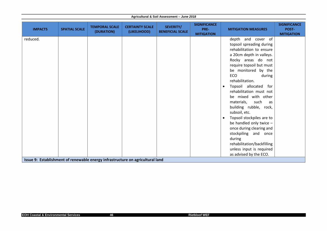
Agricultural & Soil Assessment – June 2018
EOH Coastal & Environmental Services 46 Rietkloof WEF
IMPACTS SPATIAL SCALE TEMPORAL SCALE
(DURATION) CERTAINTY SCALE
(LIKELIHOOD) SEVERITY/
BENEFICIAL SCALE
SIGNIFICANCE PRE-
MITIGATION MITIGATION MEASURES
SIGNIFICANCE POST-
MITIGATION
reduced. depth and cover of topsoil spreading during rehabilitation to ensure a 20cm depth in valleys. Rocky areas do not require topsoil but must be monitored by the ECO during rehabilitation.
Topsoil allocated for rehabilitation must not be mixed with other materials, such as building rubble, rock, subsoil, etc.
Topsoil stockpiles are to be handled only twice – once during clearing and stockpiling and once during rehabilitation/backfilling unless input is required as advised by the ECO.
Issue 9: Establishment of renewable energy infrastructure on agricultural land

Agricultural & Soil Assessment – June 2018
EOH Coastal & Environmental Services 47 Rietkloof WEF
IMPACTS SPATIAL SCALE TEMPORAL SCALE
(DURATION) CERTAINTY SCALE
(LIKELIHOOD) SEVERITY/
BENEFICIAL SCALE
SIGNIFICANCE PRE-
MITIGATION MITIGATION MEASURES
SIGNIFICANCE POST-
MITIGATION
During the construction phase the WEF infrastructure (permanent and temporary)will result in the loss of up to 5 ha of low agricultural land
Study area Medium term Definite Slight MODERATE Construction activities must only occur within the demarcated construction footprint.
LOW
Issue 10: Increase in erosion potential
During the construction phase the increase in impacted areas and hard surfaces will increase run-off and potentially lead to soil erosion
Study area Long term Definite Severe HIGH All run-off water from hard surface areas (e.g. roads, hardstands etc.) and construction impacted areas must be collected, channelled and disposed of in an appropriate manner.
Anti-erosion features must be installed where required.
Ensure that all cleared and impacted land is rehabilitated and re-vegetated.
LOW
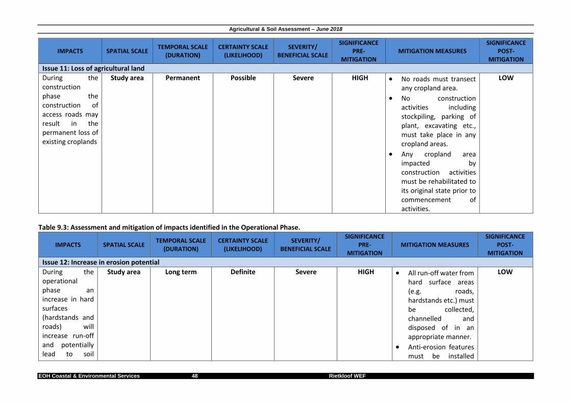
Agricultural & Soil Assessment – June 2018
EOH Coastal & Environmental Services 48 Rietkloof WEF
IMPACTS SPATIAL SCALE TEMPORAL SCALE
(DURATION) CERTAINTY SCALE
(LIKELIHOOD) SEVERITY/
BENEFICIAL SCALE
SIGNIFICANCE PRE-
MITIGATION MITIGATION MEASURES
SIGNIFICANCE POST-
MITIGATION
Issue 11: Loss of agricultural land
During the construction phase the construction of access roads may result in the permanent loss of existing croplands
Study area Permanent Possible Severe HIGH No roads must transect any cropland area.
No construction activities including stockpiling, parking of plant, excavating etc., must take place in any cropland areas.
Any cropland area impacted by construction activities must be rehabilitated to its original state prior to commencement of activities.
LOW
Table 9.3: Assessment and mitigation of impacts identified in the Operational Phase.
IMPACTS SPATIAL SCALE TEMPORAL SCALE
(DURATION) CERTAINTY SCALE
(LIKELIHOOD) SEVERITY/
BENEFICIAL SCALE
SIGNIFICANCE PRE-
MITIGATION MITIGATION MEASURES
SIGNIFICANCE POST-
MITIGATION
Issue 12: Increase in erosion potential
During the operational phase an increase in hard surfaces (hardstands and roads) will increase run-off and potentially lead to soil
Study area Long term Definite Severe HIGH All run-off water from hard surface areas (e.g. roads, hardstands etc.) must be collected, channelled and disposed of in an appropriate manner.
Anti-erosion features must be installed
LOW
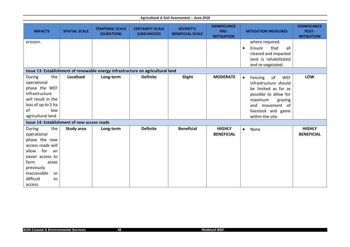
Agricultural & Soil Assessment – June 2018
EOH Coastal & Environmental Services 49 Rietkloof WEF
IMPACTS SPATIAL SCALE TEMPORAL SCALE
(DURATION) CERTAINTY SCALE
(LIKELIHOOD) SEVERITY/
BENEFICIAL SCALE
SIGNIFICANCE PRE-
MITIGATION MITIGATION MEASURES
SIGNIFICANCE POST-
MITIGATION
erosion. where required.
Ensure that all cleared and impacted land is rehabilitated and re-vegetated.
Issue 13: Establishment of renewable energy infrastructure on agricultural land
During the operational phase the WEF infrastructure will result in the loss of up to 5 ha of low agricultural land
Localised Long-term Definite Slight MODERATE Fencing of WEF infrastructure should be limited as far as possible to allow for maximum grazing and movement of livestock and game within the site.
LOW
Issue 14: Establishment of new access roads
During the operational phase the new access roads will allow for an easier access to farm areas previously inaccessible or difficult to access.
Study area Long-term Definite Beneficial HIGHLY BENEFICIAL
None HIGHLY BENEFICIAL

Agricultural & Soil Assessment – June 2018
EOH Coastal & Environmental Services 50 Rietkloof WEF
Table 9.5: Assessment and mitigation of impacts identified in the Decommissioning Phase.
IMPACTS SPATIAL SCALE TEMPORAL SCALE
(DURATION) CERTAINTY SCALE
(LIKELIHOOD) SEVERITY/
BENEFICIAL SCALE
SIGNIFICANCE PRE-
MITIGATION MITIGATION MEASURES
SIGNIFICANCE POST-
MITIGATION
Issue 15: Decommissioning and removal of renewable energy infrastructure on agricultural land
During the decommissioning phase the decrease in renewable energy development in the local area will result in an increase of available agricultural land.
Regional Long term Probable Beneficial HIGHLY BENEFICIAL
All impacted agricultural land should be rehabilitated for future agricultural use.
HIGHLY BENEFICIAL
Table 9.6: Assessment and mitigation of impacts identified in the NO-GO alternative.
IMPACTS SPATIAL SCALE TEMPORAL SCALE
(DURATION) CERTAINTY SCALE
(LIKELIHOOD) SEVERITY/
BENEFICIAL SCALE
SIGNIFICANCE PRE-
MITIGATION MITIGATION MEASURES
SIGNIFICANCE POST-
MITIGATION
Issue 16: Not constructing the WEF
Not constructing the WEF will have no impact of agricultural land.
Study area Permanent Definite N/A
N/A None N/A
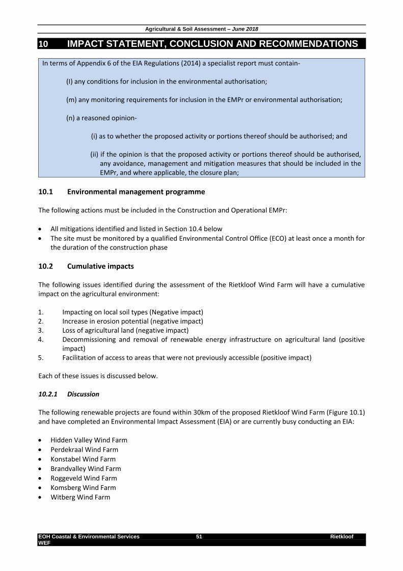
Agricultural & Soil Assessment – June 2018
EOH Coastal & Environmental Services 51 Rietkloof WEF
10 IMPACT STATEMENT, CONCLUSION AND RECOMMENDATIONS
In terms of Appendix 6 of the EIA Regulations (2014) a specialist report must contain- (I) any conditions for inclusion in the environmental authorisation; (m) any monitoring requirements for inclusion in the EMPr or environmental authorisation; (n) a reasoned opinion-
(i) as to whether the proposed activity or portions thereof should be authorised; and (ii) if the opinion is that the proposed activity or portions thereof should be authorised,
any avoidance, management and mitigation measures that should be included in the EMPr, and where applicable, the closure plan;
10.1 Environmental management programme The following actions must be included in the Construction and Operational EMPr:
All mitigations identified and listed in Section 10.4 below
The site must be monitored by a qualified Environmental Control Office (ECO) at least once a month for the duration of the construction phase
10.2 Cumulative impacts The following issues identified during the assessment of the Rietkloof Wind Farm will have a cumulative impact on the agricultural environment: 1. Impacting on local soil types (Negative impact) 2. Increase in erosion potential (negative impact) 3. Loss of agricultural land (negative impact) 4. Decommissioning and removal of renewable energy infrastructure on agricultural land (positive
impact) 5. Facilitation of access to areas that were not previously accessible (positive impact) Each of these issues is discussed below. 10.2.1 Discussion The following renewable projects are found within 30km of the proposed Rietkloof Wind Farm (Figure 10.1) and have completed an Environmental Impact Assessment (EIA) or are currently busy conducting an EIA:
Hidden Valley Wind Farm
Perdekraal Wind Farm
Konstabel Wind Farm
Brandvalley Wind Farm
Roggeveld Wind Farm
Komsberg Wind Farm
Witberg Wind Farm

Agricultural & Soil Assessment – June 2018
EOH Coastal & Environmental Services 52 Rietkloof WEF
All above-mentioned projects locations as shown in Figure 1 below were considered in the cumulative impact statement. It must be noted however that although an Environmental Authorisation (EA) may be received for most of these projects, not all will be constructed. All these projects all still subjected to a Department of Energy (DoE) procurement process which will determine which of these projects may proceed to construction phase. This will have an impact on the overall cumulative impact statement.
Figure 10.1. Renewable projects within 50km of the proposed Rietkloof Wind Farm. During the operational phase the new access roads will allow for an easier access to farm areas previously inaccessible or difficult to access. 10.2.2 Impact statement Each of the cumulative impacts identified in this assessment are discussed below: Issue 1: Increase in erosion potential The increase in impacted areas and hard surfaces (hardstands and roads) will increase run-off and may potentially lead to an overall increase in soil erosion potential for the local area. This may be further enhanced as a result of inappropriate stormwater design for each project. The local area is allocated a low erosion potential by the Department of Agriculture (http://www.agis.agric.za/agisweb/agis.html). A LOW cumulative impact is allocated based on the following:
The current erosion potential is low A study of some of these projects (including Hidden Valley, Konstabel & Gunsfontein wind farms) shows that the development of a stormwater management plan is required prior to commencement of construction for each of these sites. It is therefore emphasised that a stormwater management plan must be implemented for the proposed Rietkloof Wind Farm.
Agricultural & Soil Assessment – June 2018
EOH Coastal & Environmental Services 53 Rietkloof WEF
Issue 3: Loss of agricultural land Design and construction of the proposed Rietkloof Wind Farm will contribute approx. 150ha to the overall potential loss of around 1 800ha (calculated at an average of 150ha per project) of agricultural land. It has been previously mentioned that a low agricultural potential has been allocated to the area. This is due to the unsuitability of the local soil types for agricultural crop purposed as well as the low carrying capacity of the local veld. Although irrigation do occur onsite, almost all projects will avoid these areas resulting in a LOW significance for cropland. The cumulative impact on grazing land is considered as LOW due to the following:
The area has a low carrying capacity
Agricultural potential is low Issue 4: Impacting on local soil types The planning and design of a new wind farm will result in the loss of local soil types. These soil types mostly include Mispah & Glenrosa soil types (shallow and/or rocky soils) for all projects in the 50km radius as this is the dominant soil types. Both these soil types are not suitable for irrigation or dryland cropping but low potential grazing of both livestock (sheep & goats mostly) and game do occur. Some of the younger and deeper soils found in river-valley bottoms are utelised for crop irrigation provided that water is available. Although a high cumulative impact is anticipated due to the number of projects that will impact on these soil types, a LOW cumulative significance is allocated based on the following: • Mispah & Glenrosa soils are commonly found onsite • It has no high value use other that low grazing • Irrigated soils are avoided by the proposed development Issue 14: Establishment of new access roads. Construction of the Rietkloof Wind Farm will result in areas of land that was not previously accessible to the landowner to be accessed. Constructing new roadways as part of the wind farm infrastructure will allow the landowner to use these roadways to access more areas to use for agricultural purposes (rangeland, crops etc.) These areas may not have been accessible before due to topography (mountains, hills, etc.) or was not financially viable to utilise due to long distances. Issue 15: Decommissioning and removal of renewable energy infrastructure on agricultural land The decommissioning and removal of renewable energy infrastructure in 20-25 years’ time will result in a cumulative increase of up to 150ha of available agricultural land for each project that was constructed. 10.2.3 Conclusion Even though there are a large number of renewable energy projects in the area, the overall cumulative impact is considered as LOW. Each Wind Farm is spread over a large geographical area, resulting in limited impact on local soil types as well as agricultural potential for individual farms.
10.3 Recommendations for the proposed Rietkloof WEF 10.3.1 Alternatives
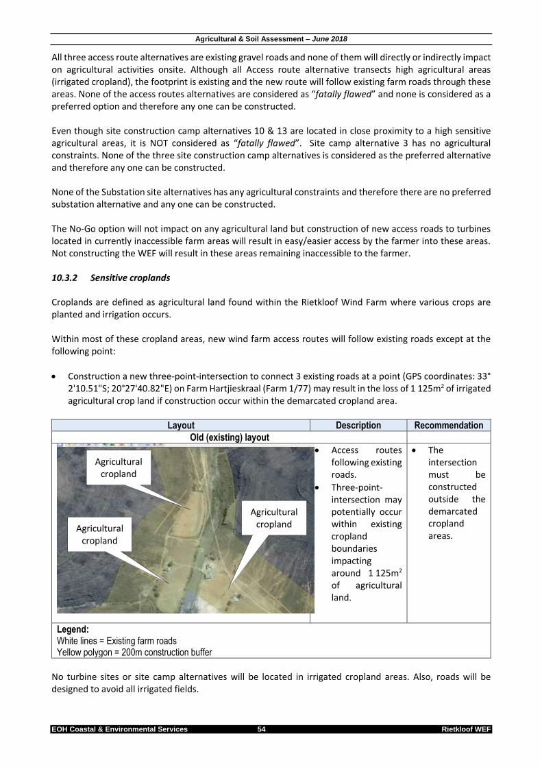
Agricultural & Soil Assessment – June 2018
EOH Coastal & Environmental Services 54 Rietkloof WEF
All three access route alternatives are existing gravel roads and none of them will directly or indirectly impact on agricultural activities onsite. Although all Access route alternative transects high agricultural areas (irrigated cropland), the footprint is existing and the new route will follow existing farm roads through these areas. None of the access routes alternatives are considered as “fatally flawed” and none is considered as a preferred option and therefore any one can be constructed. Even though site construction camp alternatives 10 & 13 are located in close proximity to a high sensitive agricultural areas, it is NOT considered as “fatally flawed”. Site camp alternative 3 has no agricultural constraints. None of the three site construction camp alternatives is considered as the preferred alternative and therefore any one can be constructed. None of the Substation site alternatives has any agricultural constraints and therefore there are no preferred substation alternative and any one can be constructed. The No-Go option will not impact on any agricultural land but construction of new access roads to turbines located in currently inaccessible farm areas will result in easy/easier access by the farmer into these areas. Not constructing the WEF will result in these areas remaining inaccessible to the farmer. 10.3.2 Sensitive croplands Croplands are defined as agricultural land found within the Rietkloof Wind Farm where various crops are planted and irrigation occurs. Within most of these cropland areas, new wind farm access routes will follow existing roads except at the following point:
Construction a new three-point-intersection to connect 3 existing roads at a point (GPS coordinates: 33° 2'10.51"S; 20°27'40.82"E) on Farm Hartjieskraal (Farm 1/77) may result in the loss of 1 125m2 of irrigated agricultural crop land if construction occur within the demarcated cropland area.
Layout Description Recommendation
Old (existing) layout
Access routes following existing roads.
Three-point-intersection may potentially occur within existing cropland boundaries impacting around 1 125m2 of agricultural land.
The intersection must be constructed outside the demarcated cropland areas.
Legend: White lines = Existing farm roads Yellow polygon = 200m construction buffer
No turbine sites or site camp alternatives will be located in irrigated cropland areas. Also, roads will be designed to avoid all irrigated fields.
Agricultural cropland
Agricultural cropland Agricultural
cropland

Agricultural & Soil Assessment – June 2018
EOH Coastal & Environmental Services 55 Rietkloof WEF
10.3.3 Mitigation measures All the mitigation measures provided below are to be implemented in the Planning & Design, Construction and Operation Phases of the proposed Rietkloof WEF. Planning and Design phase
Appropriate stormwater structures must be designed and implemented.
All infrastructure situated on slopes must incorporate stormwater diversions.
Develop a Rehabilitation and Monitoring Plan to monitor stockpiles.
Avoid developing on high potential agricultural land (like irrigated areas, croplands, etc.).
If unavoidable, ensure that all development footprints are kept at a minimum.
Where possible, the development of access roads (and other infrastructure) must avoid impacting existing croplands.
If not possible, the loss of cropland must be offset by preparing a new cropland in close vicinity to the lost area.
Offset areas must be the same size as lost areas.
Offset areas must be located in areas where both the landowner/occupier and the developer has agreed on prior to commencement of construction.
Construction phase
Machinery must be properly maintained to keep oil leaks in check.
If a spill occurs on a permeable surface (e.g. Soil), a spill kit must be used to immediately reduce the potential spread of the spill.
If a spill occurs on an impermeable surface such as cement or concrete, the surface spill must be contained using oil absorbent materials.
Contaminated remediation materials must be carefully removed from the area of the spill so as to prevent further release of hazardous chemicals to the environment, and stored in adequate containers until appropriate disposal in a licenced landfill site.
Ensure that all personnel are aware of the fire risk and the need to extinguish cigarettes before disposal, in appropriate waste disposal containers.
Smoking will only be allowed in demarcated areas with easy access to firefighting equipment.
Welding and other construction activities requiring open flames shall be done in a designated area containing firefighting equipment.
The risk of fire is highest in the late summer and autumn months, during high wind velocities and dry periods. To avoid and manage fire risk the following steps should be implemented:
o Have on site fire-fighting equipment and ensure that all personnel are educated how to use it and procedures to be followed in the event of a fire.
o Identify the relevant authorities and structures responsible for fighting fires in the area and shall liaise with them regarding procedures should a fire commence.
o Ensure that all the necessary telephone numbers (including local Farmers Association Fire Marshall) to use in a case of an emergency are displayed at conspicuous and relevant locations.
o No open fires shall be allowed on site for the purpose of cooking or warmth. Cooking fires must only be lit in designated cooking areas.
The contractor shall take all reasonable steps to prevent the accidental occurrence or spread of fire.
The contractor shall appoint a fire officer who shall be responsible for ensuring immediate and appropriate action in the event of a fire.
The contractor shall ensure that all site personnel are aware of the procedure to be followed in the event of a fire. The appointed fire officer shall notify the Fire and Emergency Services in the event of a fire and shall not delay doing so until such time as the fire is beyond his / her control.
The contractor shall ensure that there is basic fire-fighting equipment on site at all times. This equipment shall include fire extinguishers and beaters.

Agricultural & Soil Assessment – June 2018
EOH Coastal & Environmental Services 56 Rietkloof WEF
Any work that requires the use of fire may only take place within designated areas. Fire-fighting equipment shall be available in these areas.
Develop and implement a Rehabilitation and Monitoring Plan to monitor rehabilitated areas.
Ensure that topsoil does not get buried by subsoil during stockpiling. Failure to comply may result in topsoil sterilisation.
Implement measures such as wind-breaks, swales and watering as required aiding the initial grown of primary vegetation.
Fertile topsoil must not be stockpiled for periods exceeding 12 months or exceeding 2m in height to avoid topsoil sterilization. If unavoidable, the appointed ECO must monitor topsoil stockpile fertility to avoid sterility of soils.
Topsoil may be supplemented with an indigenous seed mix.
The upper 15-20 cm of top soil must be stripped and stockpiled as topsoil where possible. It should be retained for re-spreading over disturbed surfaces during rehabilitation.
All other soil excavated will be stockpiled separately from topsoil as subsoil.
Ensure that topsoil does not get buried by subsoil during backfilling. Failure to comply may result in topsoil sterilisation.
An ECO must monitor all excavations to ensure backfilling with subsoil first and then topsoil afterwards takes place.
An ECO must monitor depth and cover of topsoil spreading during rehabilitation to ensure a 20cm depth in valleys. Rocky areas do not require topsoil but must be monitored by the ECO during rehabilitation.
Topsoil allocated for rehabilitation must not be mixed with other materials, such as building rubble, rock, subsoil, etc.
Topsoil stockpiles are to be handled only twice – once during clearing and stockpiling and once during rehabilitation/backfilling unless input is required as advised by the ECO.
Construction activities must only occur within the demarcated construction footprint.
All run-off water from hard surface areas (e.g. roads, hardstands etc.) and construction impacted areas must be collected, channelled and disposed of in an appropriate manner.
Anti-erosion features must be installed where required.
Ensure that all cleared and impacted land is rehabilitated and re-vegetated.
No roads must transect any cropland area.
No construction activities including stockpiling, parking of plant, excavating etc., must take place in any cropland areas.
Any cropland area impacted by construction activities must be rehabilitated to its original state prior to commencement of activities.
Operational phase
All run-off water from hard surface areas (e.g. roads, hardstands etc.) must be collected, channelled and disposed of in an appropriate manner.
Anti-erosion features must be installed where required.
Ensure that all cleared and impacted land is rehabilitated and re-vegetated.
Fencing of WEF infrastructure should be limited as far as possible to allow for maximum grazing and movement of livestock and game within the site.
Decommissioning phase
All impacted agricultural land should be rehabilitated for future agricultural use.
10.4 Conclusions The following table summarises the change in impacts from pre- to post- mitigation for the Rietkloof Wind Farm.
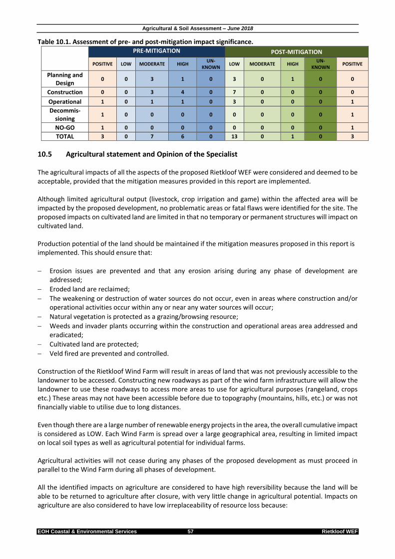
Agricultural & Soil Assessment – June 2018
EOH Coastal & Environmental Services 57 Rietkloof WEF
Table 10.1. Assessment of pre- and post-mitigation impact significance.
PRE-MITIGATION POST-MITIGATION
POSITIVE LOW MODERATE HIGH UN-
KNOWN LOW MODERATE HIGH
UN- KNOWN
POSITIVE
Planning and Design
0 0 3 1 0 3 0 1 0 0
Construction 0 0 3 4 0 7 0 0 0 0
Operational 1 0 1 1 0 3 0 0 0 1
Decommis-sioning
1 0 0 0 0 0 0 0 0 1
NO-GO 1 0 0 0 0 0 0 0 0 1
TOTAL 3 0 7 6 0 13 0 1 0 3
10.5 Agricultural statement and Opinion of the Specialist The agricultural impacts of all the aspects of the proposed Rietkloof WEF were considered and deemed to be acceptable, provided that the mitigation measures provided in this report are implemented. Although limited agricultural output (livestock, crop irrigation and game) within the affected area will be impacted by the proposed development, no problematic areas or fatal flaws were identified for the site. The proposed impacts on cultivated land are limited in that no temporary or permanent structures will impact on cultivated land. Production potential of the land should be maintained if the mitigation measures proposed in this report is implemented. This should ensure that:
Erosion issues are prevented and that any erosion arising during any phase of development are addressed;
Eroded land are reclaimed;
The weakening or destruction of water sources do not occur, even in areas where construction and/or operational activities occur within any or near any water sources will occur;
Natural vegetation is protected as a grazing/browsing resource;
Weeds and invader plants occurring within the construction and operational areas area addressed and eradicated;
Cultivated land are protected;
Veld fired are prevented and controlled. Construction of the Rietkloof Wind Farm will result in areas of land that was not previously accessible to the landowner to be accessed. Constructing new roadways as part of the wind farm infrastructure will allow the landowner to use these roadways to access more areas to use for agricultural purposes (rangeland, crops etc.) These areas may not have been accessible before due to topography (mountains, hills, etc.) or was not financially viable to utilise due to long distances. Even though there are a large number of renewable energy projects in the area, the overall cumulative impact is considered as LOW. Each Wind Farm is spread over a large geographical area, resulting in limited impact on local soil types as well as agricultural potential for individual farms. Agricultural activities will not cease during any phases of the proposed development as must proceed in parallel to the Wind Farm during all phases of development. All the identified impacts on agriculture are considered to have high reversibility because the land will be able to be returned to agriculture after closure, with very little change in agricultural potential. Impacts on agriculture are also considered to have low irreplaceability of resource loss because:
Agricultural & Soil Assessment – June 2018
EOH Coastal & Environmental Services 58 Rietkloof WEF
1. of the small area of land involved; 2. low suitability for crops outside small areas along dry riverbeds that are currently under irrigation; 3. it is highly unlikely to be irreplaceably lost to agriculture; 4. of a low agricultural potential for livestock; 5. agricultural activities will not cease during any phases of development; and 6. the proportion of surface area likely to be affected is minimal and therefore the overall impact on the
carrying capacity/agricultural potential of the site will be minimal.
11 REFERENCES Agricultural Research Council. undated. Available at http://www.agis.agric.za/ (last visited on 11 June 2014).

Agricultural & Soil Assessment – June 2018
EOH Coastal & Environmental Services 59 Rietkloof WEF
Deckers, J., Driessen, P., Nachtergaele, F., and Spaargaren, O. (2006) World Reference Base for Soil Resources (WRB) – in a nutshell. European Soil Bureau – Research Report no. 7 EKZNW (2010) Terrestrial Systematic Conservation Plan: Minimum Selection Surface (MINSET). Unpublished GIS Coverage [tscp_minset_dist_2010_wll.zip], Biodiversity Conservation Planning Division, Ezemvelo KZN Wildlife, P. O. Box 13053, Cascades, Pietermaritzburg, 3202. Moore, G. Dolling, P. Porter, B. and Leonard, L. (1998) Soil Acidity. In Soilguide. A handbook for understanding and managing agricultural soils. (Ed. G Moore) Agriculture Western Australia Bulletin No. 4343. Munica, L, Scott-Shaw CR, Rutherford MC, Camp KGT, Matthews WS, Powrie LW and Hoare DB (2006) Indian Ocean Coastal Belt In: The vegetation of South Africa, Lesotho and Swaziland, Mucina L and Rutherford (eds). South African National Biodiversity Institute, Pretoria. National Environmental Management Act (No 107 of 1998) as amended in 2010 National Water Act (No 36 of 1998) Soil Classification Working Group. (1991) Soil Classification - A Taxonomic System for South Africa Mohamed, Najma. 2000. "Greening Land and Agrarian Reform: A Case for Sustainable Agriculture", in At the Crossroads: Land and Agrarian Reform in South Africa into the 21st century, ed. Cousins, Ben. Bellville, School of Government, University of the Western Cape.
12 APPENDIX A – SOIL LABORATORY RESULTS

Agricultural & Soil Assessment – June 2018
EOH Coastal & Environmental Services 60 Rietkloof WEF
13 APPENDIX B – SPECIALIST DECLARATION

Agricultural & Soil Assessment – June 2018
EOH Coastal & Environmental Services 61 Rietkloof WEF