Embed Size (px)
Citation preview

Agroforestry Systems 61: 35–50, 2004.© 2004 Kluwer Academic Publishers. Printed in the Netherlands.
35
Riparian forest buffers in agroecosystems – lessons learned from the BearCreek Watershed, central Iowa, USA
R.C. Schultz1,∗, T.M. Isenhart 1, W.W. Simpkins2 and J.P. Colletti11Department of Natural Resource Ecology and Management, 253 Bessey, Iowa State University, Ames, IA 50011-1020; 2Department of Geologic and Atmospheric Sciences, Iowa State University; ∗Author for correspondence:e-mail: [email protected]
Key words: Buffer design, Buffer maintenance, Filter strips, Surface runoff, Water quality
Abstract
Intensive agriculture can result in increased runoff of sediment and agricultural chemicals that pollute streams.Consensus is emerging that, despite our best efforts, it is unlikely that significant reductions in nutrient loading tosurface waters will be achieved through traditional, in-field management alone. Riparian forest buffers can playan important role in the movement of water and NPS (non-point source) pollutants to surface water bodies andground water. Riparian buffers are linear in nature and because of their position in the landscape provide effectiveconnections between the upland and aquatic ecosystems. Present designs tend to use one model with a zone ofunmanaged trees nearest the stream followed by a zone of managed trees with a zone of grasses adjacent to thecrop field. Numerous variations of that design using trees, shrubs, native grasses and forbs or nonnative cool-seasongrasses may provide better function for riparian forest buffers in specific settings. Properly designed riparian buffershave been shown to effectively reduce surface NPS pollutant movement to streams and under the right geologicalriparian setting can also remove them from the groundwater. Flexibility in design can also be used to producevarious market and nonmarket goods. Design flexibility should become more widely practiced in the applicationof this agroforestry practice.
Introduction
Intensive agriculture, as practiced in much of thetemperate zone, is not environmentally friendly asevidenced by the major non-point source (NPS) pol-lution problems that have befallen many surface waterbodies. The size of cultivated fields continues to in-crease to accommodate large equipment, and livestockproduction continues to be concentrated into larger fa-cilities producing major amounts of waste that mustbe disposed of safely. In many landscapes of theMidwestern United States, more than 85% of the land-scape is devoted to row crop agriculture or intensivegrazing (Burkart et al. 1994). It is unlikely that thesetrends will slow in the near future as more food needsto be produced efficiently to feed a growing world pop-ulation. Increased surface runoff laden with sedimentand agrochemicals continue to provide higher and
more frequent peak flows that result in more flooding,incision and widening of stream channels, reductionof base flow, and reduction in the quality of aquaticecosystems (Menzel 1983).
Consensus is emerging that, despite our best ef-forts, it is unlikely that significant reductions in nutri-ent loading to surface waters will be achieved throughtraditional, in-field management alone (Dinnes et al.2002). Recognizing the gravity of the problem, pub-lic agencies are looking to augment these traditionalpollution-control efforts by utilizing landscape buf-fers as off-site sinks for contaminants (MississippiRiver/Gulf of Mexico Watershed Nutrient Task Force2001; Mitsch et al. 2001). One such effort in theUnited States is the Conservation Buffer Initiative, apublic-private program with the goal to assist in the es-tablishment of 3.2 million km of conservation buffers,mainly through the use of the continuous United States
36
Department of Agriculture (USDA) Conservation Re-serve Program. A host of different buffers that reducesurface movement of soil and agricultural chemicalsby wind and/or water have been developed. Theseinclude such practices as: alleycropping, constructedwetlands, cross-wind trap strips, field borders, filterstrips, riparian forest buffers, vegetative barriers, andwindbreaks and shelterbelts, to name a few. The ef-fectiveness of most of these practices can be improvedif they are used in combination throughout the land-scape. However, while conservation buffers have greatpotential to assist in meeting our stewardship goals,Lowrance et al. (2002) concluded that key knowledgegaps still exist and that future research results need tobe translated into up-to-date technical standards andguidelines for conservation buffer design, installation,and maintenance.
Infield conservation practices are designed to trapand slow the movement of materials near their source.Filter strips and riparian forest buffers are designed asecotones between upland and aquatic ecosystems andprovide the last conservation practice that slows move-ment and traps materials before they enter surfacewater bodies. These buffers may be the only majorperennial plant conservation practice that is used alongintermittent streams (channels that carry water onlyduring the wet part of the year) and some first orderstreams (with no tributaries). Because of the smallsize of the stream, cultivation can be easily and re-latively safely carried on right down to the channelbank putting the stream in direct contact with thecultivated field source of NPS pollutants. In higherorder streams (streams with one or more tributaries;example: 4th order stream occurs when two 3rd or-der streams join) they should be supplemented withother perennial plant conservation practices to insuremaximum phytoremediation of NPS pollutants beforereaching the buffers.
Riparian forest buffers are a recognized agro-forestry practice that not only provide phytoremedi-ation for NPS pollutants but also increase biodiversityof both the terrestrial and aquatic ecosystems. Theycan also provide stream bank stabilization, moder-ate flooding damage, recharge groundwater, sequestercarbon and provide recreational opportunities andfiber and nonfiber products to landowners.
This chapter will describe the structure, function,design and maintenance of riparian forest buffers andgrass filters based on work that has been conductedin the Bear Creek Watershed in central Iowa, UnitedStates (42◦ 11′ N, 93◦ 30′ W). Because of the extens-
ive research and demonstration activities that havebeen conducted for more than a decade, this water-shed has been designated as a National RestorationDemonstration Watershed by the interagency team im-plementing the Clean Water Action Plan (1999) andas the Bear Creek Riparian Buffer National Researchand Demonstration Area by the USDA (1998). Mostof the discussion will address the establishment ofnew buffers along first to fourth order streams, wherepresent cultivation extends to near the stream edge orriparian grazing is practiced by fencing in the narrowriparian corridor that may be difficult to cultivate withlarge machinery because of the tight meandering ofthe stream. Establishing buffers under these conditionsusually requires complete restoration of a perennialplant community as none has existed for decades orhas been very heavily impacted by grazing pressure.
What is a riparian forest buffer?
A riparian forest buffer is specifically defined as athree zone system consisting of an unmanaged woodyzone adjacent to the water body followed upslope bya managed woody zone and bordered by a zone ofgrasses with or without forbs (Welsch 1991; Isenhartet al. 1997). The major objectives of a riparian bufferare:1. To remove nutrients, sediment, organic matter,pesticides, and other pollutants from surface runoffand groundwater by deposition, absorption, plant up-take, denitrification, and other processes, and therebyreduce pollution and protect surface water and subsur-face water quality while enhancing the ecosystem ofthe water body,2. To create shade to lower water temperature toimprove habitat for aquatic organisms, and3. To provide a source of detritus and large woodydebris for aquatic organisms and habitat for wildlife(USDA-NRCS 2003).
Riparian forest buffers can vary in design in re-sponse to management objectives. The vertical andhorizontal structure of the woody and grass zones maydiffer from one location to the next, depending on:1. Landowner objectives, concerns, experiences andbiases,2. Present condition of the site,3. Major functions of the proposed buffer system, and4. Short and long term management practices to beemployed.

37
Table 1. Typical landowner concerns about riparian forest buffers.
1. How much can buffers reduce the movement of sediment and other pollutants to the stream?
2. Can buffers heal gullies?
3. What happens to water moving rapidly over grass waterways when it intersects a buffer?
4. Can buffers slow stream meandering?
5. What buffer vegetation produces the best wildlife habitat and fishery?
6. Can buffers reduce stream bank erosion?
7. If a riparian forest buffer is planted will trees fall into the stream and back up water into the fields or drain tiles?
8. Is the buffer a source of weed seeds?
9. Are cool-season grass filters just as effective as riparian forest buffers?
10. Will riparian forest buffers bring beavers that build dams that also back up water?
11. Will deer become a problem for crops?
12. How much maintenance is required and who will do it?
13. If fencing is used to keep livestock out of a buffer will it be damaged by floods?
14. How much land will be taken out of crop production or pasture?
15. Can specific products be harvested from the buffers to offset income losses?
16. Are there consultants who can design, plant and maintain the buffers?
17. Are there government programs to help pay for the practice?
They can consist of existing riparian forests or beestablished on previously cultivated or grazed land.While this chapter focuses primarily on riparian forestbuffers in the agricultural landscape, they may also befound in forested, suburban and urban landscapes.
In a forest landscape riparian buffers are often re-ferred to as streamside management zones and usuallyconsist of only a forested zone. Management activitiessuch as thinning, fertilizing and harvesting are usuallydramatically restricted, if allowed at all. In suburbanlandscapes, riparian forest buffers usually consist ofexisting forests that border on residential or commer-cial developments. If these forests are protected andmanaged they can provide the natural functions offiltering and processing of suburban pollutants asso-ciated with runoff from roads, lawns and constructionsites. They can also provide noise control and screen-ing along with their wildlife habitat and aestheticbenefits. In the more urbanized environment, riparianforest buffers are often very narrow and fragmented tothe point that they may not be completely functionalforest ecosystems. However, with proper planning andzoning, these forests can play an important role instorm water management. These forests are often thelargest and most continuous forests in the urban en-vironment and therefore provide significant wildlifehabitat and recreational opportunities. However, as useof these areas increase, their pollutant control abilityis often reduced. Because these buffers often are loc-ated on highly prized land, the goal of suburban and
urban planning is to protect them from developmentand overuse by the public (Palone and Todd 1997).
Riparian forest buffers in the agricultural land-scape can take numerous forms. In the eastern UnitedStates, they may exist as narrow corridors of remnantforests along the stream or as irregular islands alongportions of meandering streams. In many cases theseforests have been grazed in the past. In much of theintensive agricultural belt of the Midwestern UnitedStates, riparian forest buffers have to be reestablishedfrom scratch on land that was cropped or grazed formany decades. In the arid and semiarid west, riparianforest buffers consist of narrow tree and shrub zonesin a vast expanse of grazed dry upland shrubs andgrasses (Elmore 1992). Because riparian forest com-munities evolved in the most fertile and moist positionof the landscape, they can often be easily reestab-lished. However, in many agricultural landscapes landuses have so dramatically changed the hydrology thatthese communities cannot be restored to their originalcondition. Stream channels have been incised andwidened by higher discharge resulting from greatersurface runoff from crop fields and heavily grazed pas-tures. Channelization of meandering streams, tiling ofsome landscapes and urbanization also have contrib-uted to higher storm flow and lower baseflow (Menzel1983). In many cases, water table depths have beenlowered to the point that restored buffers require adifferent community structure to function properly.However, with proper planning and design the func-

38
tions of a healthy riparian forest community can bereestablished.
As an agroforestry practice, riparian forest buf-fers play an important role in the movement of waterthrough the agricultural landscape and in the move-ment of NPS pollutants to surface water bodies andground water. They are linear in nature, and becauseof their position in the landscape, they provide ef-fective connections between the upland and aquaticecosystems in a watershed.
Assessing the need for riparian buffers
The design of a buffer system will strongly influ-ence the expression of each of the buffer functions ona specific site. It is therefore imperative that beforedesigning a riparian buffer an assessment of the site beconducted as well as the landowner’s objectives andconcerns identified. Concerns that landowners typ-ically have about designing and adopting a riparianbuffer are summarized in Table 1.
After landowner objectives have been identifiedand concerns have been satisfied it is time to assessthe present condition of the stream and riparian zone.While a lot of information can be gained from aerialphotos it is imperative that the entire site is walkedand a detailed site map identifying problem areas isdeveloped. Walking the site with the landowner is anexcellent option. Items to look for and questions to an-swer while making the field assessment are indicatedin Table 2.
Once the landowner’s questions have been ad-dressed and the site assessment has been completedthe design process may begin. If the adjacent land-use,including that of the riparian zone is row crop agricul-ture a riparian forest buffer or filter is probably needed(Figure 1). The choice between a riparian forest bufferand a filter strip will depend on landowner preferencesand site conditions. Where steep vertical stream banksof ≥ 2 m exist, some kind of woody vegetation is re-commended to provide strong perennial woody rootsthat strengthen stream bank soils. If the stream bankis gently sloping with a ≥ 3:1 slope (for every 1 unitvertical rise there is a 3 unit horizontal setback), onlya native grass/forb filter may be needed depending onthe desires of the landowner and the long-term man-agement of the buffer. These options will be discussedin detail in the following sections.
If a narrow strip of trees, 3 m to 10 m wideis already present along the stream bank only a fil-
Table 2. Field assessment guidelines for designing a riparianforest buffer.
Questions to address in a site inventory.
1. What is the order of the stream?
2. Is the stream listed as an impaired waterway?
3. Is it a naturally meandering or channelized reach?
4. Is the channel in contact with the flood plain or deeplyincised?
5. What is the stage of channel evolution – is it deepening,widening or beginning to stabilize (Schumm et al. 1984)?
6. How high are the banks above the streambed and are theyvertical or sloping?
7. Is bank erosion naturally slow or accelerated?
8. Are there major slumps or eroded sections and are these as-sociated with gullies or areas of concentrated flow or on theoutside of bends?
9. What is the dominant land use of the riparian zone?
10. What is the land-use immediately adjacent to the channel– does vegetation cover consist of annual row crops, a nar-row strip of weedy vegetation, permanent forest or forageproduction, or grazed pasture?
11. Does the weedy vegetation consist of dense introducedgrasses or annual weeds?
12. What is the condition of any forest vegetation?
13. Is livestock grazed rotationally, providing significant restperiods for re-growth or intensively grazed with completeaccess to the banks and channel?
14. Are there drainage tiles emptying into the stream?
15. Are there upslope areas of concentrated flow that should bein grassed waterways?
16. Is it a cold- or warm-water fishery?
17. Is there evidence of a healthy aquatic invertebrate com-munity?
ter may be needed to effectively intercept upsloperunoff. If stream banks are vertical, and if roads, struc-tures or other valuable property is being threatenedby stream bank erosion, then stream bank bioengin-eering techniques may have to be used in additionto any riparian buffers (Figure 2). In-stream struc-tures such as boulder weirs or riffle structures mayalso be used to help stabilize both the stream banksand the channel bed. If field drainage tiles pass be-low any buffer on their way to dumping into thestream, consider developing a wetland to intercept theflow before it enters the stream. Biological activityin the wetland can effectively remove a number ofthe primary chemical pollutants threatening surfacewaters (Crumpton 2001).

39
Figure 1. Pasture and crop sites that are in need of riparian buffers. Banks in A are gentle enough that native grasses and forbs could be plantedat the edge of the bank. Banks in B are steep enough that their stability would be improved with woody roots.
Designing the buffer
The traditional riparian forest buffer consists of threezones (Figure 3). The first zone is unmanaged forestalong the stream bank, left unmanaged to provideshading and large woody debris to the stream. Thesecond zone consists of forest that is managed as anutrient sink with systematic harvests to remove trees.The third zone consists of a grass and/or grass-forbfilter strip that intercepts and slows the usually concen-trated surface runoff from adjacent fields and spreadsit over a wider front to move more slowly through theriparian buffer.
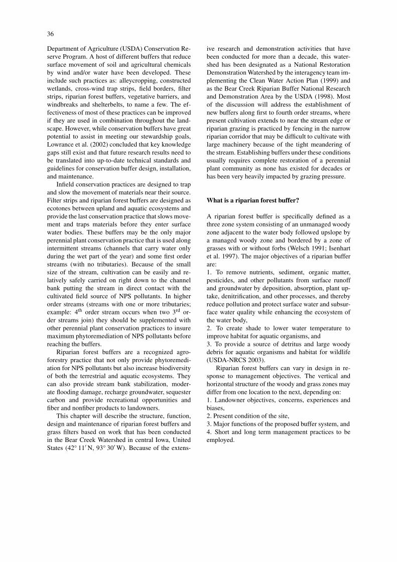
Experience with landowners in some regions sug-gests that zone 1 in the three-zone system is of concernto landowners who do not want trees falling intostreams slowing water that they feel needs to be car-ried rapidly from the landscape. This concern resultedin the development of the two-zone multi-species ri-parian buffer consisting primarily of a woody zoneand a grass or grass-forb filter zone (Figure 4). In thismodel, the whole woody zone is managed but may beplanted to combinations of trees and shrubs.
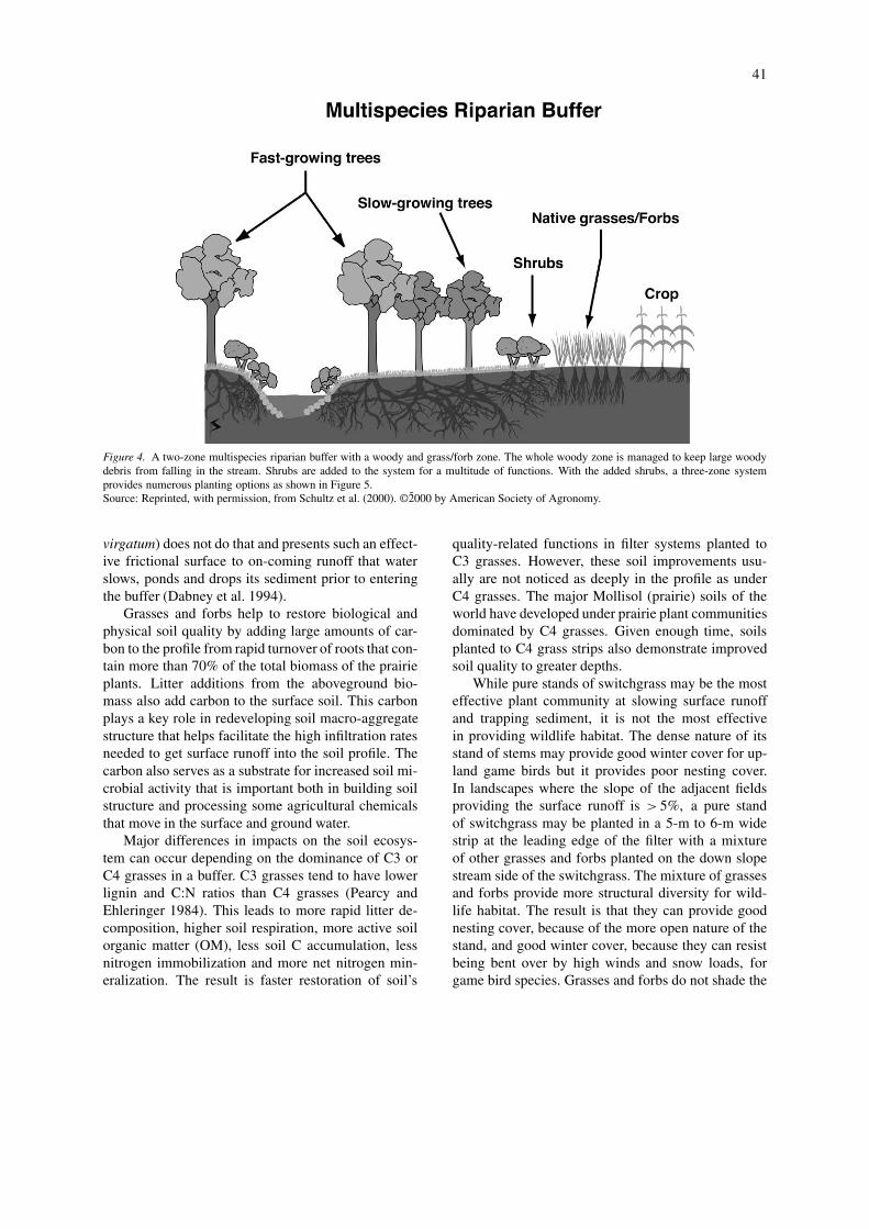
Further experience with this model and landowneracceptance led to the development of a model withmultiple combinations of woody and non-woodyzones as discussed below (Figure 5). In this model thebuffer is divided into three zones that may be occu-pied by trees, shrubs and grasses or grasses and forbs.Within each of these plant communities, a wide varietyof species and zone widths can be used depending ondesign requirements.
Functions of grasses and forbs
Grasses and/or grasses and forbs provide excellentground cover (Table 3). They can be designed toprovide the frictional surface needed to slow surfacerunoff from the adjacent field allowing the sediment inthe runoff to be dropped in the crop field and convert-ing much of the concentrated flow into a wider front ofslower moving water approaching sheet flow. Much ofthis slower moving water can infiltrate into the buf-fered soil where it will have extended contact timewith the ‘living filter’ of the soil-plant system. Sur-face runoff that moves through the buffer continues tomove slowly dropping further sediment and infiltratingmore water and soluble nutrients.
Most non-native forage grasses such as Bromusinermis, Phleum pratense and Poa pratensis do notpresent stiff leaves to the on-coming surface runoff.Rather they are easily laid down, allowing water tomove rapidly over them. This feature is very effect-ive in the grass waterway conservation practice wherethe objective is to carry water rapidly down slopingdepressions within row-crop fields while protectingthe mineral soil surface. When these grasses are usedin zone 3 of a riparian buffer they may be inund-ated with sediment in large runoff events becauseslopes are usually between 0% to 2%, slowing waterenough to drop most of the sediment (Dillaha et al.1989). When this occurs, the filter becomes ineffect-ive in slowing further surface runoff. Even among thenative warm-season grasses, differences exist in thepresentation of a highly frictional surface to incomingrunoff. While most native warm-season grasses arestrong clump-forming types providing corridors formovement between the clumps, switchgrass (Panicum

40
Figure 2. Riparian management system practices including from top right: streambank bioengineering, in-stream boulder weir structures,intensive rotational grazing, constructed wetlands and riparian buffer.Source: Reprinted, with permission, from Schultz et al. (2000). © 2000 by American Society of Agronomy.
Figure 3. The traditional three zone riparian buffer.Source: Reprinted, with permission, from Schultz et al. (2000). ©2̃000 by American Society of Agronomy.
41
Figure 4. A two-zone multispecies riparian buffer with a woody and grass/forb zone. The whole woody zone is managed to keep large woodydebris from falling in the stream. Shrubs are added to the system for a multitude of functions. With the added shrubs, a three-zone systemprovides numerous planting options as shown in Figure 5.Source: Reprinted, with permission, from Schultz et al. (2000). ©2̃000 by American Society of Agronomy.
virgatum) does not do that and presents such an effect-ive frictional surface to on-coming runoff that waterslows, ponds and drops its sediment prior to enteringthe buffer (Dabney et al. 1994).
Grasses and forbs help to restore biological andphysical soil quality by adding large amounts of car-bon to the profile from rapid turnover of roots that con-tain more than 70% of the total biomass of the prairieplants. Litter additions from the aboveground bio-mass also add carbon to the surface soil. This carbonplays a key role in redeveloping soil macro-aggregatestructure that helps facilitate the high infiltration ratesneeded to get surface runoff into the soil profile. Thecarbon also serves as a substrate for increased soil mi-crobial activity that is important both in building soilstructure and processing some agricultural chemicalsthat move in the surface and ground water.
Major differences in impacts on the soil ecosys-tem can occur depending on the dominance of C3 orC4 grasses in a buffer. C3 grasses tend to have lowerlignin and C:N ratios than C4 grasses (Pearcy andEhleringer 1984). This leads to more rapid litter de-composition, higher soil respiration, more active soilorganic matter (OM), less soil C accumulation, lessnitrogen immobilization and more net nitrogen min-eralization. The result is faster restoration of soil’s
quality-related functions in filter systems planted toC3 grasses. However, these soil improvements usu-ally are not noticed as deeply in the profile as underC4 grasses. The major Mollisol (prairie) soils of theworld have developed under prairie plant communitiesdominated by C4 grasses. Given enough time, soilsplanted to C4 grass strips also demonstrate improvedsoil quality to greater depths.
While pure stands of switchgrass may be the mosteffective plant community at slowing surface runoffand trapping sediment, it is not the most effectivein providing wildlife habitat. The dense nature of itsstand of stems may provide good winter cover for up-land game birds but it provides poor nesting cover.In landscapes where the slope of the adjacent fieldsproviding the surface runoff is > 5%, a pure standof switchgrass may be planted in a 5-m to 6-m widestrip at the leading edge of the filter with a mixtureof other grasses and forbs planted on the down slopestream side of the switchgrass. The mixture of grassesand forbs provide more structural diversity for wild-life habitat. The result is that they can provide goodnesting cover, because of the more open nature of thestand, and good winter cover, because they can resistbeing bent over by high winds and snow loads, forgame bird species. Grasses and forbs do not shade the
42
Figure 5. Vegetation combinations in a three-zone buffer system. The crop field is on the left and the stream is on the right. Vegetation zonescan vary in width in addition to species and species of trees, shrubs and grasses can vary within a zone.
stream, which is important in warm water ecosystems,nor do they provide significant detrital inputs for theaquatic ecosystem.
Functions of shrubs
Shrubs add the longevity of a woody root system anda more permanent nutrient sink to the buffer (Table 3).While most shrubs are multi-stemmed they are ableto sequester nutrients in their woody biomass. Thewoody root system provides strength to soil profiles.Annual leaf fall and fine-root turnover provide signi-ficant organic matter (OM) to the O and A horizonsof the soil profile. OM additions are not usually foundas deep in the profile as under C4 grass and forb eco-systems (Tufekcioglu et al. 1999) but C:N ratios ofmany native shrub leaves are conducive to rapid de-composition that helps to rapidly rebuild surface soilquality.
The multiple stem nature of shrub species providesan effective barrier that traps floodwater debris in thebuffer rather than letting it move out into the adja-cent fields. The multiple stem system also providescover for wildlife and wind reductions near the groundproviding thermal cover. Their size and shape providesanother layer of vertical structure that fits between thegrasses and trees. In most regions, a wide variety ofshrub species can be planted in riparian buffer set-tings providing a diverse food source and cover fora wide variety of bird and wildlife species as wellas providing the potential for ornamental woody cutproduction.
Because shrubs are usually limited to < 5 m inheight, they do not provide much shade to the chan-nel but provide perennial woody roots that can addstrength to stream bank soils. While the larger woodyroots of shrubs are not as massive as those on trees theycan still add more effective strength to the stream bankprofile than grasses and forbs. Because of their shorter

43
Table 3. Functions of the grass, shrub and tree components of riparian buffers.
Kind of Plant Functions
Prairie grasses/forbs 1. Slow water entering the buffer
2. Trap sediment and associated chemicals
3. Add organic carbon to a range of soil depth
4. Added carbon improves soil structure
5. Improve infiltration capacity of the surface soil
6. Above ground nutrient sink needs annual harvest
7. Provide diverse wildlife habitat
8. Do not significantly shade the stream channel
9. Provide only fine organic matter input to stream
10. Can provide forage and other products
Shrubs 1. Multiple stems act as a trap for flood debris
2. Provide woody roots for bank stabilization
3. Litter fall helps improve surface soil quality
4. Above ground nutrient sink needs occasional harvest
5. Adds vertical structure for wildlife habitat
6. Do not significantly shade the stream channel
7. Provide only fine organic matter input to stream
8. Can provide ornamental products and berries
Trees 1. Strong, deep woody roots stabilize banks
2. Litter fall helps improve surface soil quality
3. Long-lived, large nutrient sink needs infrequent harvest
4. Adds vertical structure for wildlife habitat
5. Vertical structure may inhibit buffer use by grassland birds
6. Shade stream, lowering temperature and stabilizing dissolved oxygen
7. Provide both fine organic matter and large woody debris to the channel
8. Can provide a wide variety of fiber products
stature, shrubs often are not major sources of in-streamdetritus that can support aquatic invertebrates.
Functions of trees
The aboveground woody biomass of trees provides alarge C and N sink that can be systematically removedto maintain the storage capacity of a buffer (Table 3).The large woody roots that often can be found ex-tending 2 m to 3 m or more into the soil provideadditional strength to stream banks. High transpira-tion rates and deep roots help to dewater moist streambanks improving their stability.
Native riparian species are always a good choiceon most sites but many landowners have concerns withsome of them because they tend to be short-lived andbreak up easily under natural storm events. Most of
the native riparian species are prolific spring seedersand either root- or stump sprout; so, even though theymay be short-lived and may succumb to storm eventsthey rapidly re-establish themselves. Root sproutingspecies are ideal for planting directly adjacent or onstream banks because they can spread rapidly present-ing a highly frictional surface to base and storm flows.Planting these species near the field edge of the buf-fer is not recommended, however, because these sameroot sprouting species often migrate out into portionsof the crop field becoming a nuisance to farmers.
Depending on the depth of the aerated root zone, awide variety of tree species can be planted. If channelsare incised at least 2 m to 3 m in depth, many commonupland species can be included in the design especiallyif care is taken to plant them on the microtopographicrises of the riparian zone. These species are oftenrequested by landowners who see them as providing

44
potential quality fiber products at some future date andhard mast for a variety of wildlife species. While con-ifers are usually not recommended for planting nearthe channel because of the damage that they can in-cur from flooding, they can provide effective wintercover if planted in double or triple rows on rises inthe riparian zone. Species diversity in the tree com-ponent of any buffer is critical to the longevity of thatcomponent. Mixing species within and between rowsis strongly recommended to reduce the potential oflarge holes in the buffer corridor resulting from insector pathogen problems. Native species are also recom-mended over non-native species and hybrids as theyare usually better adapted to the site over the long run.
The size and shape of trees provides yet anotherdimension to the vertical and horizontal structure ofa buffer site. This addition to structure can providehabitat that will attract the largest diversity of wild-life and bird species to the buffer. However, if specificspecies of birds, such as grassland birds, are desiredthe added vertical structure can be detrimental becauseof the abrupt edges that are introduced in the narrowcorridor. In addition, trees provide perches for ma-jor avian predators who can wreak havoc on otherbirds and mammals that are ‘trapped’ in the corridorscreated by the buffers.
Trees are effective in shading streams and provid-ing both fine and large detritus to the channel. Thefine detritus provides a readily available carbon sourcefor many invertebrates while the large woody debrisprovides structure to the channel that can create poolsand riffles that provide stability to channel dischargeand additional habitat within the channel. Shading ofmany streams in agricultural landscapes can help con-trol stream water temperature and reduce the widefluctuations in dissolved oxygen that often degradesthe quality of the fishery. (Wesche et al. 1987)
Questions may be raised about the appropriatenessof planting trees in previously prairie landscapes if res-toration is an issue. While native prairie grasses andforbs may be desirable trees may provide functions,such as stream bank stabilization, that are needed inthe present riparian corridor. This is especially truein dominantly agricultural landscapes where the hy-drology of the landscape has been drastically modifiedand many channels are no longer in contact with theirriparian zone.
Examples of different combinations of plantcommunities in the three zone system
Filter strip
The combination depicted in Figure 5.1 is effectivein narrow buffers along intermittent and first orderstreams in row-crop landscapes where shading of ad-jacent crops is a concern or where warm-water prairiefisheries are being managed. Species options in-clude non-native cool-season forage grasses that couldprovide forage harvests, or, if fenced, could be flash-grazed several times per year. Native warm-seasongrasses and forbs provide another option if prairie res-toration and grassland bird-habitat are desired or ifserious surface runoff problems exist. Pure switch-grass could be planted if there is a biomass market or ifcrop field slopes are ≥ 5%. If the stream bank is gentlysloped (slopes of 6:1) and the channel not deeply in-cised, then either of the grass species options wouldbe effective. As the banks become steeper (slopes 4:1)and the channel more incised, the native prairie specieswould provide more bank-stability control because ofdeeper roots.
Filter strip with bank-side shrubs
The system depicted in Figures 5.2 and 5.3 can alsobe used in a headwaters reach (first order stream)along a warm-water fishery in a prairie or crop-fieldlandscape. The advantage of shrubs over trees is thatthey do not shade the stream and do not provide largewoody debris that some landowners may not want.The shrubs would be introduced primarily to providemore stream bank stability on channels that are incisedwith steep banks (slopes 4:1 to 3:1). While bioengin-eering of stream banks is an option, it is a costly one– and, realistically, not cost-effective in most settings.Depending on the severity of the incision, the shapeof the banks and the dynamics of the channel both thestream-edge zone (zone 1) and the second zone couldbe planted to shrubs recognizing that, over time, someof the first rows of shrubs might not hold the erodingbanks and may drop into the channel. Shrubs couldalso be planted along streams with flashy flood flowresponses where large quantities of debris could betrapped between the shrubs and the channel insteadof extending out over and beyond the whole buffer.This might be an important consideration in suburbanbuffers where trails are a part of the buffer.
45
Classic multi-species riparian forest buffer
Introduction of trees into the buffer is warrantedwhen streams are deeply incised and in the wideningmorphological phase of the channel-evolution model(Schumm et al. 1984), when maximum abovegroundnutrient storage is desired, cooler more stable streamtemperatures are desired, and/or when the land ownerwants maximal structural habitat diversity, a woodyfiber crop, or wind protection. Figures 5.4 and 5.5 de-pict this option. Trees also provide large woody debrisand finer detrital inputs to the channel. Addition ofthe shrubs in zone 2 not only provides more struc-ture to the system but can effectively keep woody andother flood debris within the woody zone of the buffer(Schultz et al. 1995).
This buffer combination can be modified by revers-ing the shrub- and tree zones with the shrubs in zone 1adjacent to the channel. This modification would beconsidered along warm-water prairie streams wherethe landowner wants woody products and other treebenefits but does not want the tree influence on thechannel, including input of large woody debris. Simil-arly, this combination would be effective along deeplyincised channels of prairie streams where woody ve-getation is desired to help stabilize the stream banks.Multiple rows of shrubs and trees would be advised es-pecially on outside bends that move continuously andwhere woody plants would provide effective controluntil they have reached critical sizes. This combin-ation could also be effective in urban settings withwidely spaced rows between which trails could beplaced. The more open wider spacing would providea more expansive visual experience and a safety factorfor trail users.
Classic three-zone riparian forest buffer
The riparian forest buffer depicted in Figure 5.6 wouldbe used in naturally forested landscapes and in cold-water fisheries especially where small streams havesignificant channel slope and can benefit from largewoody debris inputs. In prairie landscapes, this modelis also effective in deeply incised settings with act-ively meandering channels. In these settings makingboth the grass buffer and the woody zones as wide aspossible can provide long-term bank control in lieu ofstream bank bioengineering.
This model also provides the largest abovegroundnutrient sink and can be managed as either a two orthree zone system depending on the need to removenutrients from the site and the desire for in-stream,
large woody debris. By being sensitive to micrositeconditions, a wide variety of species can be plantedto provide a variety of fiber product options to thelandowner.
All three zones can be planted to trees in riparianpastures. In this setting surface runoff laden with sed-iment is not a major concern but limiting access oflivestock to the stream channel providing bank stabil-ity is. With the proper spacing, such a planting couldbe managed as a silvopastoral system with rotationalgrazing to control the time livestock spend on streambanks and in the channel.
Additional general design considerations
When working in agricultural landscapes, buffer edgesshould be as straight or gently curving as possible toaccommodate farming practices (Figure 6). Bufferswill be maintained and supported by farmers if they donot see them as hindering their farming operation. Thisoften means spending time on site with the landownerto discuss his or her field layout. Differences in bufferwidth to accommodate field borders can be absorbedby either the woody or the grass-forb zone, dependingon the site. In those landscapes where surface runoffis more problematic than stream bank stability, main-taining a wider grass-forb zone would be favored overa wider tree-shrub zone.
In tightly meandering reaches, the buffer should beplaced outside of the channel meander belt. The areaswithin the meanders as well as other small odd-sizedareas provide ideal opportunities for developing primewildlife habitat. Along channelized streams, buffersshould be as wide as possible to accommodate thefuture re-meandering of the channelized reach. Thelandowner is more likely to allow the re-meanderingif the adjacent riparian area is no longer being usedfor crop production. If the channelized reach is part ofan organized drainage district, only grasses or grassesand forbs should be planted across all three zones toallow access for channel maintenance.
The potential also exists in any buffer planting toinclude even more agroforestry options. These mightinclude planting horticultural varieties of shrubs formaking jams, selling nuts, or providing ornamentalwoody material for home decorating. Fruit or nut treescould also be planted. These options may provideunique opportunities for small-truck farmers or hobbyfarmers but may not suit grain and livestock farm-ers who often do not have the time to invest in suchplantings. The potential also exists that these more ex-

46
Figure 6. Examples of buffers placed outside the meander belt of the stream and smooth buffer borders to accommodate efficient farming ofthe upland crop fields. Areas within the meander belt are also planted to a variety of species to provide diverse wildlife habitat.
pensive plants could be severely damaged during floodevents and a substantial investment in time and moneycould be lost.
Establishing buffers
Establishing buffers is best accomplished by work-ing with local natural resource professionals who un-derstand the unique requirements of each site. Theunderlying assumption for most of the chapter hasbeen that recommended buffers and filters would berestored on sites that previously were intensively man-aged for livestock grazing or row-crop agriculture.Some general establishment considerations follow.
One of the major differences between planting buf-fers and planting forest plantations to maximize timberproduction is that woody buffer plants must competewith ground vegetation that is designed to provide thefrictional surface required to slow surface runoff. Asa result, when planting a riparian forest buffer intoprevious row-crop field soils, it is advisable to planta cover of grasses and/or forbs that provide minimalcompetition of young trees and shrubs. Density of thetrees and shrub planting should be such that the surfacecover community remains viable during the life of thebuffer or at least until a major organic (O) horizon hasbeen developed above the mineral soil.
Site preparation before planting is imperative ifgood establishment is to occur and should begin thefall prior to spring planting. Previously row-croppedsites may be shallow-disked several times, followedby broadcast or drilled seeding of undercover grasses.
If planting into an abandoned pasture, using herbi-cide to create narrow strips or individual circles intowhich to plant the trees and shrubs is recommended.Herbicides can be used but great care must be takenbecause of the neighboring stream channel. Herbi-cide recommendations are best obtained from localnatural resource professionals. Other weed-control op-tions such as shade cloth or plastic or organic mulchescan be effective in some circumstances but may bemore costly to apply to the large plantings.
If planting native prairie grasses and forbs, diskingshould be followed by packing to allow proper depthcontrol for the drilled small seeds of many prairie spe-cies. Broadcasting of prairie seeds followed by rollingcan also be successful. Once again, it is important tocontact local professionals for the best method of es-tablishment. Planting of woody material can be donein rows or in a random broadcast manner. Rows allowseedlings to be planted more rapidly with machinesand allow easier mechanical maintenance for the firstfew years. If using seedlings, select individuals withlarge root systems that include five or more large lat-eral roots to assure rapid establishment and growth.Replanting holes of missing woody plants during thefirst two to three years should be done to establish acontinuous buffer barrier. Broadcast planting of treeseeds can also be done rapidly; but then there is noinitial control of density and less control of speciesdiversity. However, broadcast seeded plantings mayrequire less early maintenance because germinationproduces very dense stands of seedlings that control

47
competing vegetation. The dense sapling stands alsothin themselves effectively over time.
Maintenance of planted riparian buffers
Mowing of both the woody and grass zones can bebeneficial during the first few years of establishment.Native grasses and forbs often germinate and growmore slowly than local weeds or non-native grasses.Local weeds can pose a problem for the farmer. Mow-ing at 40 cm to 60 cm heights, twice a season, beforemajor annual weed seeds mature, can minimize thoseproblems. Using a flail chopper mower instead of abrush-hog will scatter the cut debris rather than win-drowing it. Windrows of debris can choke some smallyoung prairie plants. The last mowing may be plannedfor late summer or fall to allow enough regrowth tooccur to provide fuel for prescribed spring burns.
Mowing between woody plant rows reduces shad-ing of young seedlings and helps identify rows. How-ever, during very hot dry windy weather shading bytaller weeds may benefit young seedlings. Mowingbetween woody plant rows late in the season may con-centrate rodents in the seedling rows where they maygirdle plants, unless herbicides have kept the seed-ling rows clear of weeds. Careful use of pre-emergentherbicides in the woody plant rows may help rapidestablishment of seedlings.
Prescribed fire is a useful tool to help establishprairie communities. Annual spring burns during thefirst three or four years can produce good stands ofdesired grasses and forbs. Burning regimes of three tofive year frequency should be used once the desiredspecies are established. Alternating fall burns may beused to stimulate forb species over grasses that arestimulated by spring burns. Care is required to conductthese prescribed burns in the narrow zones that can liebetween woody species and extensive row crops. Withgood planning and careful attention to weather andsite conditions, these burns can be successful. As withother planting and maintenance recommendations, itis always good to check with local professionals aboutthe best burning regime to establish and maintain thefilter zone planting.
Trees can be pruned to improve form if trees willbe harvested for timber products in the future. This isespecially true for the higher quality hardwood speciesthat are planted on the higher microtopographic loca-tions of the buffer. Systematic thinning and harvestingare required to maintain an active woody plant nutrient
sink. Once a given number of stems in a buffer havereached the natural production limit of the buffer, nonew nutrient storage biomass is added to the trees. In-stead, the trees naturally thin themselves allowing thesurviving trees to continue to expand. The trees thatdie naturally will add their nutrients back to the buffersoil making it available for transport to the stream. Amanagement plan should be developed with the help ofa local natural resource professional to schedule theseremovals and to assure regeneration of the next stand.
One of the major fallacies with buffers is that theycan be planted and then left on their own. For themto remain effective buffers, extensive management isrequired. While not intensive during each year, annualsite evaluation and long-term maintenance is a must.For example, if sediment berms are found to be build-ing up along the filter edge between the crop field andthe buffer, corrective disking and replanting may berequired to reduce the chance that concentrated flowpathways do not develop through the buffer.
How well do buffers carry out their prescribedfunctions?
Extensive studies in the Bear Creek Watershed overthe past decade have demonstrated the efficacy of buf-fers to remove non-point source pollution from surfaceand ground water as well as improve the biologicalintegrity of both the terrestrial buffer and the adja-cent aquatic stream ecosystem. However, these studieshave also demonstrated that there is wide variabil-ity of functions related to the variability of alluviallandscapes and that buffers may not be effective atcontrolling pollution in some settings.
Process-oriented studies that have been completedas part of the Bear Creek Watershed Project include:soil carbon and aggregate dynamic studies (Marquezet al. 1999; Marquez 2000), denitrification and soilmicrobiological studies (D.M. Haake 2003. Land useeffects on soil microbial carbon and nitrogen in ri-parian zones in Northeast Missouri. M.S. Thesis. IowaState University. 56 pp.; J.L. Nelson. 2003. Denitrific-ation in riparian soils in three NE Missouri watersheds.

48
M.S. Thesis. Iowa State University. 44 pp.; J.E. Pickle1999. Microbial biomass and nitrate immobilizationin a multi-species riparian buffer. M.S. Thesis. IowaState University. 86 pp.); surface runoff and infilt-ration studies (Bharati et al. 2002; Lee et al. 1999,2000, 2003); above- and below-ground biomass, car-bon, nitrogen and soil respiration studies (Tufekciogluet al. 1999; Tufekcioglu et al. 2000; Tufekciogluet al. in press); fine root decay rates (M.E. Dorn-bush. 2001. Fine root decay: a comparison amongthree species. M.S. Thesis. Iowa State University.109 pp.); streambank erosion studies (G.N. Zaimes1999. Streambank erosion adjacent to riparian land-use practices and stream patterns along Bear Creek,in north central Iowa. M.S. Thesis. Iowa State Uni-versity. 58 pp.; Zaimes et al. 2004); and surface flowpath and spatio-temporal modeling studies (Hameed1999; D. Webber. 2000. Comparing estimated surfaceflowpaths and sub-basins derived from digital eleva-tion models of Bear Creek Watershed in central Iowa.M.S. Thesis. Iowa State University. 82 pp.). A seriesof studies have been conducted on stream substrateand fish diversity, small mammal diversity in nativegrass and forb vs. cool-season grass filter portions ofthe riparian forest buffer and bird species composition(unpublished data).
Hydrogeological studies have also been conduc-ted to establish the connection between surface andgroundwater processes. These studies have included:geology and hydrogeology of the 1990 planting site,groundwater interaction with Bear Creek, hydrogeo-logy and groundwater quality below a cool-seasongrass buffer and two multi-species buffers, assess-ing groundwater velocity and denitrification potentialbeneath a multi-species buffer using natural-gradienttracer tests and application of geophysics and innov-ative groundwater sampling to optimize placement offuture buffers in the watershed (Simpkins et al. 2002).Several socioeconomic analyses have also been con-ducted in the Bear Creek Watershed and in the MarkTwain Watershed in Missouri where companion stud-ies have been conducted (Brewer 2002; Colletti et al.1993). Major conclusions from these studies includethose listed below.1. A 7-m wide native-grass filter can reduce sedimentloss by more than 95% and total nitrogen and phos-phorus and nitrate and phosphate in the surface runoffby more than 60%. Adding a 9-m wide woody-bufferresults in removal of 97% of the sediment and 80%of the nutrients. There also is a 20% increase in theremoval of soluble nutrients with the added width.
2. Water can infiltrate up to five times faster in re-stored six-year old buffers than in row cropped fieldsor heavily grazed pastures.3. Soils in riparian buffers contain up to 66%more total organic carbon in the top 50 cm thancrop field soils. Poplar hybrids (Populus spp.) andswitchgrass living and dead biomass sequester 3000and 800 kg C ha−1 yr−1 and immobilize 37 and16 kg N ha−1 yr−1, respectively. Riparian buffers havemore than eight times more below ground biomassthan adjacent crop fields.4. Buffers show a 2.5 fold increase in soil microbialbiomass and a four-fold increase in denitrification inthe surface 50 cm of soil when compared to crop fieldsoils of the same mapping unit.5. Tracer tests and isotope evidence shows that de-nitrification is the major groundwater nitrate removalmechanism in the buffers.6. Stratigraphy below buffers can determine the effect-iveness of nutrient removal from shallow groundwater.With a shallow confining layer of till below a loamyroot zone buffers can remove up to 90% of the ni-trate in groundwater. When the confining layer isfound well below the rooting zone and porous sandand gravel are found between the till and the loam,residence time and contact with roots is dramatic-ally reduced and buffers are unable to remove muchnitrate from the groundwater. The difficulty in describ-ing the stratigraphy below buffers makes it difficultto quantify the role that specific buffers might play inremediating agricultural chemicals in groundwater.7. Buffered stream banks lose up to 80% less soil thanrow cropped or heavily grazed stream banks.8. Riparian buffers can reach maximum efficiency forsediment removal in as little as 5 years and nutrientremoval in as little as 10–15 years.9. Streamside buffers cannot remove materials fromfield drainage tiles. But an acre of tile–interceptingwetland can remove 20–40 tons of N over a period of60 years.10. Stream segments with extended buffers exhibitgreater stream substrate and fish species diversity. Voleand mouse species common to the region stronglyprefer riparian forest buffers with prairie grass andforb zones instead of introduced cool-season grasszones. Riparian forest buffers support five times asmany bird species as row-cropped or heavily grazedriparian areas.11. To have a significant effect on stream water qualitycontinuous riparian buffers should be placed high up inthe watershed.
49
12. Eighty percent of farmers and town’s people agreethat buffers are an effective tool for improving streamwater quality. These same persons believe that waterquality in streams should be improved by 40%.13. Ninety percent of financial agents who appraiseagricultural land and lend money to farmers believebuffers are a net asset when considering market (fin-ancial) and nonmarket (conservation, aesthetic, envir-onmental, etc.) benefits and government assistance.When market benefits exclusively are considered, only46% think that buffers are ‘a net asset.’14. Buffers enhance recreational opportunities. Fish-ing, hunting and watching wildlife are popular uses.
Conclusion
Based on the studies that have been conducted in theBear Creek watershed, riparian buffers are effective atreducing the impact of non-point source pollutants onstream and ground water in a small order watershed.These studies have also demonstrated, however, thatthere is great variability in rates of the important bio-logical and physical processes that are responsible forthese improved conditions. Statements about generalbuffer effectiveness over a wide range of landscapesmust be made carefully and further research must beconducted to establish the range of process rates inother ecoregions around the country and the world.
It has been difficult to demonstrate the impact ofover 6 km of buffer on the water quality in Bear Creek,itself, because about a third of the watershed lies abovethe buffered portion of the creek and that part of thewatershed contains about twice as many kilometers ofchannel as the buffered reach. Yet at the field scale buf-fer efficacy has been demonstrated. This points to theneed for buffering watersheds in a systematic mannerbeginning in the headwaters and moving down stream.
While this chapter has only dealt with the designand role of riparian buffers in improving stream wa-ter and ground water quality, it must be realized thatthey are just one of a number of conservation practicesthat may be needed to make up a riparian manage-ment system. Stream bank bioengineering, in-streamflow control structures, constructed wetlands and in-tensively managed grazing systems along with a hostof upland conservation practices may all be needed toround out an effective pollution control system withina watershed.
References
Bharati L., Lee K-H., Isenhart T.M. and Schultz R.C. 2002. Riparianzone soil-water infiltration under crops, pasture and establishedbuffers. Agroforest Syst 56: 249–257.
Brewer M.T. 2002. Financial agents, water quality and riparianforest buffers. M.S. Thesis. Iowa State University, 98 pp.
Burkhart M.R., Oberle S.L., Hewitt M.J. and Picklus J. 1994. Aframework for regional agroecosystems characterization usingthe national resources inventory. J Environ Quality 23: 866–874.
Colletti J., Ball C., Premachandra W., Mize C., Schultz R., Rule L.and Gan J. 1993. A socio-economic assessment of the Bear CreekWatershed. pp. 295–302. In: Schultz R.C. and Colletti J.P. (eds),Opportunities for Agroforestry in the Temperate Zone World-wide: Proceedings of the Third North American AgroforestryConference. Ames, IA, USA.
Crumpton W.G. 2001. Using wetlands for water quality improve-ment in agricultural watersheds: The importance of a watershedscale approach. Water Sci Technol 44: 559–564.
Dabney S.M., McGregor K.C., Meyer L.D., Grissinger E.H. andFoster G.R. 1994. Vegetative barriers for runoff and sedimentcontrol. pp. 60–70. In: Mitchell J.K. (ed.), Integrated Re-source Management and Landscape Modifications for Environ-mental Protection. American Society Agricultural Engineering,St. Joseph, MI. USA.
Dillaha T.A., Reneau R.B., Mostaghimi S. and Lee D. 1989. Veget-ative filter strips for agricultural nonpoint source pollution con-trol. Transactions American Society of Agricultural Engineers32: 513–519.
Dinnes D.L., Karlen D.L., Jaynes D.B., Kaspar T.C., Hatfield J.L.,Colvin T.S. and Cambardella C.A. 2002. Nitrogen managementstrategies to reduce nitrate leaching in tile-drained Midwesternsoils. Agron J 94: 153–171.
Elmore W. 1992. Riparian responses to grazing practices. pp. 442–457. In: Naiman R.J. (ed.), Watershed Management. Springer-Verlag, New York, NY, USA.
Hameed S. 1999. Spatio-temporal Modeling in an Agricultural Wa-tershed. Ph.D. Dissertation. Iowa State University, Ames, IA.237 pp.
Isenhart T.M., Schultz R.C. and Colletti J.P. 1997. Watershed res-toration and agricultural practices in the midwest: Bear Creek inIowa. Chapter 15. In: Williams J.E., Dombeck M.P. and WoodsC.A. (eds), Watershed Restoration: Principles and Practices.American Fisheries Society.
Lee K-H., Isenhart, T.M., Schultz R.C. and Mickelson S.K. 1999.Sediment and nutrient trapping abilities of switchgrass andbromegrass buffer strips. Agroforest Syst 44: 121–132.
Lee K-H., Isenhart, T.M., Schultz R.C. and Mickelson S.K. 2000.Multispecies riparian buffers trap sediment and nutrients duringrainfall simulations. J Environ Quality 29: 1200–1205.
Lee K-H., Isenhart T.M. and Schultz R.C. 2003. Sediment and nutri-ent removal in an established multi-species riparian buffer. J SoilWater Conserv 58: 1–8.
Lowrance R., Dabney S. and Schultz R. 2002. Improving water andsoil quality with conservation buffers. J Soil Water Conserv 57:36A–43A.
Marquez C.O., Cambardella C.A., Isenhart T.M. and Schultz R.C.1999. Assessing soil quality in a riparian buffer strip system bytesting organic matter fractions. Agroforest Syst 44: 133–140.
Marquez C.O. 2000. Soil Aggregate Dynamics and Aggregate-associated Carbon under Different Vegetation Types in RiparianSoils. Ph.D. Dissertation. Iowa State University, Ames, IA.214 pp.
50
Menzel B.W. 1983. Agricultural management practices and the in-tegrity of instream biological habitat. pp. 305–329. In: SchallerF.W. and Bailey G.W. (eds), Agricultural Management and WaterQuality. Iowa State University Press, Ames, IA.
Mississippi River/Gulf of Mexico Watershed Nutrient Task Force.2001. Action Plan for Reducing, Mitigating, and ControllingHypoxia in the Northern Gulf of Mexico. Washington, DC, USA.
Mitsch W.J., Day J.W., Gilliam J.W., Groffman P.M., Hey D.L.,Randall G.L. and Wang N. 2001. Reducing nitrogen loading tothe Gulf of Mexico from the Mississippi River Basin: Strategiesto counter a persistent ecological problem. BioScience 51: 373–388.
Pearcy R.W. and Ehleringer J. 1984. Comparative ecophysiology ofC3 and C4 plants. Plant Cell Environ. 7: 1–13.
Palone R.S. and Todd A.H. (eds) 1997. Chesapeake Bay riparianhandbook: A Guide for Establishing and Maintaining RiparianForest Buffers. USDA For. Serv. NA-TP-02-97. USDA-FS, Rad-nor, PA.
Schultz R.C., Colletti J.P., Isenhart T.M., Simpkins W.W., MizeC.W. and Thompson M.L. 1995. Design and placement of amulti-species riparian buffer strip system. Agroforest Syst 31:117–132.
Schumm S.A., Harvey M.D. and Watson C.C. 1984. Incised chan-nel morphology, dynamics and control. Water Resour. Publ.,Littleton, CO.
Simpkins W.W., Wineland T.R., Andress R.J., Johnston D.A., CaronG.C., Isenhart T.M. and Schultz R.C. 2002. Hydrogeological
constraints on riparian buffers for reduction of diffuse pollution:examples from the Bear Creek Watershed in Iowa, USA. WaterSci Technol 45: 61–68.
Tufekcioglu A., Raich J. W., Isenhart T.M. and Schultz R. C. 1999.Root biomass, soil respiration, and root distribution in crop fieldsand riparian buffer zones. Agroforest Syst 44: 163–174.
Tufekcioglu A., Raich J.W., Isenhart T.M. and Schultz R.C. 2000.Soil respiration in riparian buffers and adjacent croplands. PlantSoil. 229: 117–124.
Tufekcioglu A., Raich J.W., Isenhart T.M. and Schultz R.C. In press.Biomass, carbon and nitrogen dynamics of multi-species riparianbuffer zones within an agricultural watershed in Iowa, USA.Agroforest Syst.
USDA-NRCS. 2003. National Handbook of Conservation Practices.United States Department of Agriculture, Washington, D.C.
Welsch D. J. 1991. Riparian Forest Buffers: Function and Design forProtection and Enhancement of Water Resources. NA-PR-07-91.USDA Forest Service, Radnor, Pennsylvania.
Wesche T.A., Goertler C.M. and Frye C.B. 1987. Contribution ofriparian vegetation to trout cover in small streams. North Am JFish Manage 7: 151–153.
Zaimes G.N., Schultz R.C. and Isenhart T.M. 2004. Stream bankerosion adjacent to riparian forest buffers, row-cropped fields andcontinuously-grazed pastures along Bear Creek in Central Iowa.J Soil Water Conserv 59: 19–27.