Embed Size (px)
Citation preview
RISCURI ŞI CATASTROFE, NR. XVII, VOL. 23, NR.2/2018
71
TRANSFORMATIONS OF SOMEŞ RIVER BED IN THE URBAN AREA OF SATU MARE
C-O. MAREȘ
Abstract. Transformations of Someş River bed in the urban area of Satu
Mare. The study captures the spatial-temporal evolution of the Someș river bed
and the anthropic interference over it in the metropolitan area of Satu Mare. Over
time the inhabitants of these lands led a permanent struggle with Someș waters,
which flooded frequently. Due to the low drainage slope and the intense
meandering in the urban sector, over time a series of hydro-technical works for
rectifying the river bed and embankments to reduce the effects of the floods were
needed. Before 1777 there were 39 meanders on the territory of the urban area,
which through extensive works have now been suppressed. The works performed
took place in three main stages. Through these works were converted into
agricultural land and later in built surfaces about 800 ha of swamps and arms. Due
to the hydro technical works the length of the course in the urban area decreased
from 36.5 km to 13 km. The cross-sections made at the Satu Mare hydrometric
station revealed a deepening of the river valley in its own alluviums due to the
influence of several factors.
Keywords: meanders, slope, rectification, profile, rehabilitation, instability,
ecosystem, Satu Mare.
1. INTRODUCTION
Satu Mare municipality is located in the north-western extremity of
Romania, at the intersection of the parallel 47°47'30'' N latitude with the meridian
of 22°52'30'' E longitude, the intersection of the two coordinates junctioning in the
proximity of the Decebal bridge. It has developed in the central sector of Someș'
low plain, at an average altitude of 126 m (NMN). From a geomorphological point
of view, the studied area falls to the Micula Plain to the north of Someş and Someș
Plain - Homorod to the South. Hydrographic, the municipality is located in the
lower part of Someş, at a distance of about 15 km upstream of the river's exit from
Romania and about 40 km upstream of the confluence of Someş with Tisa. The
Someş River basin is extended on an area of 15740 km2 of which 15217 km
2 in the
territory of Romania. The total length of Someș is 427 km, out of which 376 km in
Romania and 51 km in Hungary. On the territory of Satu Mare County it is about
60 km, out of which about 13 km are in Satu Mare metropolitan area, which
crosses the east - west direction.
C-O. MAREȘ
72
The emergence and subsequent evolution of the urban core is determined by
the cooperation of natural factors with favourable historical and socio-economic
ones. The presence of the numerous meanders of Someș constituted a natural
fortification, causing the emergence of the primary urban nucleus in this sector of
intense divagation. The urban area presented at its beginnings two urban nuclei
Sătmar (Zotmar) and Mintiu (Németi). Around the centre - the Villa Zotmar,
inhabited by the natives, the Teutonic settled around the year 1000 and later the
German colonists arrived on these lands. Documentary attestation as a well-defined
locality appears as Castrum Zathmar (1213) or Castrum Zhotmar (1239). The
name Sătmar would derive from the Salzmarkt toponym, a salt merchant (salt
brought to Someş from Ocna Dej), but a derivation from the Latin satum is not
excluded.
In the same period, on the opposite shore of Someș is built another locality
called Mintiu (Németi) by German settlers brought by Queen Gizela, the wife of
King Stephan I of Hungary, the very toponym of the city then supporting this fact,
(Nemes meaning German in Hungarian).
It is supposed that Mintiu existed at the beginning of the 11th century. Satu
Mare (Zhotmar) was located south of a Someș River and Mintiu (Németi), north of
Someș. The two settlements were distinct localities and were connected by a
wooden bridge, their defence against the floods of the Someș being made through
palisade-type dams. The existence of the two settlements took place in a permanent
battle with Someș' waters and its floods.
2. DATA AND METHODS
The maps were developed using GIS methods, methods for re-establishing
the route of the old Someș' bed and the meandering system. The database was
represented by the raster and sketch representations provided by the Satu Mare
County Council, Satu Mare County Museum, Satu Mare SGA and Satu Mare
National Archives. Also, the consultations of the various bibliographic sources
have added a lot of information used in the elaboration of the present material. The
approached research methods consisted from direct observation in the field,
analysis and interpretation of the cartographic and written materials. The editing
and processing of cartographic elements was done through the Arcmap program.
Editing cross-sections was done through Office Excel.
3. RESULTS AND DISCTIONS
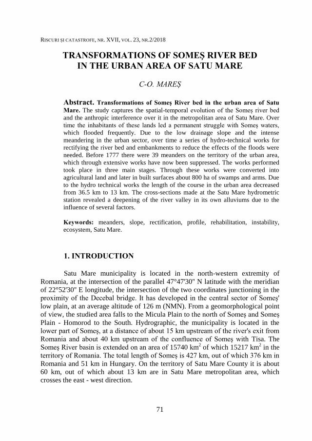
Due to a low drainage slope of 0.2 - 0.5%, the Someș River presents a
strong meandering in the lower section. Prior to 1777, in the urban area there were
about 25 meanders downstream and 14 upstream, revealing the drowning of the
TRANSFORMATIONS OF SOMEŞ RIVER BED IN THE URBAN AREA OF SATU MARE
73
river in its own alluvial deposits. After the regularizations made in the year
mentioned, 5 meanders upstream and 9 downstream are quoted. Thus, the course
length in the urban perimeter was very large measuring about 36.5 km.
Fig. 1. Perimeter of the urban centre and the river bed of Someș, XIIIth
century (Source:
Reconstruction after Satu Mare County Council data)
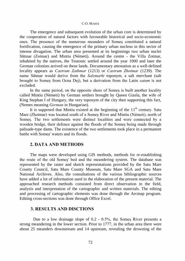
After 1543, a series of corrections were made to the Someș River bed in
order to defend the fortress. Through these works the fortification remains isolated
on an island and is connected to the main roads by three bridges. The Sătmar
(Szatmar) urban core was formed along a central street forming a square, which
followed the curved trajectory of the Someș meander. Since 1691 there have been
processes for the rectification of Someș River bed, dams and swamps. The
processes of backfilling and rectification of Someș' meanders were particularly
high in the years 1712-1715. Much of the embankment and sanitation work was
carried out by the farmers 'association, especially in the Someș' urban sector.
In 1760 it was decided to remove the arm that separated the towns of
Mintiu (Nemeti) and Sătmar (Szatmar) through a shuttle.
C-O. MAREȘ
74
Fig. 2. Rectification stapes of Someș River bed in the urban area of Satu Mare.
Reconstruction after Satu Mare County Museum data.
Due to the bed rectification, Someș' old meander formed a jog, gradually
sanitized, and its place was occupied by gardens and green areas.
Filling the ditch's fortress and the old meander was a gradual process over
the years. The reconstruction from 1780 still retains the route of the old meander.
The hydro-technical rectification works included three main stages:
- 1760 especially in the south and the centre of the urban area;
-1814 predominantly in the western sector;
-1831 in the eastern sector of the urban area.
TRANSFORMATIONS OF SOMEŞ RIVER BED IN THE URBAN AREA OF SATU MARE
75
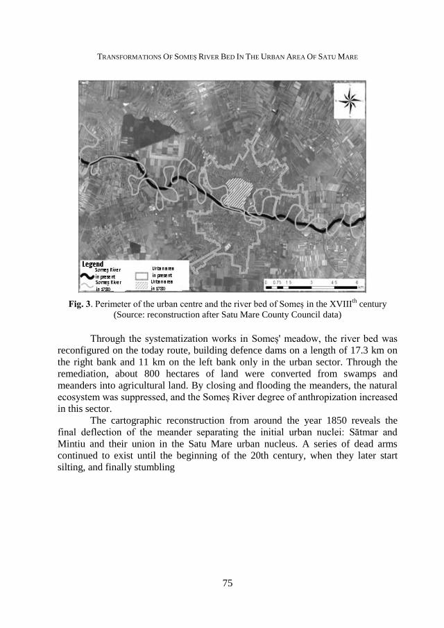
Fig. 3. Perimeter of the urban centre and the river bed of Someș in the XVIIIth
century (Source: reconstruction after Satu Mare County Council data)
Through the systematization works in Someș' meadow, the river bed was
reconfigured on the today route, building defence dams on a length of 17.3 km on
the right bank and 11 km on the left bank only in the urban sector. Through the
remediation, about 800 hectares of land were converted from swamps and
meanders into agricultural land. By closing and flooding the meanders, the natural
ecosystem was suppressed, and the Someș River degree of anthropization increased
in this sector.
The cartographic reconstruction from around the year 1850 reveals the
final deflection of the meander separating the initial urban nuclei: Sătmar and
Mintiu and their union in the Satu Mare urban nucleus. A series of dead arms
continued to exist until the beginning of the 20th century, when they later start
silting, and finally stumbling

C-O. MAREȘ
76
Fig. 4. Perimeter of the urban centre and the river bed of Someș around 1850
(Source: reconstruction after Satu Mare County Council data)
Fig. 5. Perimeter of the urban centre and the river bed of Someș at present
(Source: reconstruction after Satu Mare County Council data)
At present, the Someș River has an almost straight track along the urban
route, with 90% of the river bed being anthropically rectified in the urban area. The
length of the river bed of the urban sector is about 13 km.
TRANSFORMATIONS OF SOMEŞ RIVER BED IN THE URBAN AREA OF SATU MARE
77
4. CONCLUSIONS
Anthropic actions have had a great impact on the geographic space of the
studied area.
The impact is manifested by:
• Deformations of the observable topographic surface and currently in the
old meander sector;
• Instability of the foundation ground requiring careful design of the
foundation structure;
• Infiltrations in the buildings basements on the route of old meanders
known that the modification of the river bed does not imply implicitly the final
change of the underground course;
• Suppression of the natural ecosystem in the studied territory, specific to
wetlands ecosystem;
• Significant change of the elements of the geographical space in the Satu
Mare urban area;
• The profound change of landscape elements with the high level of
urbanization
from the studied area;
• corroborated with the construction of the current dams, the flood risk has
been significantly reduced;
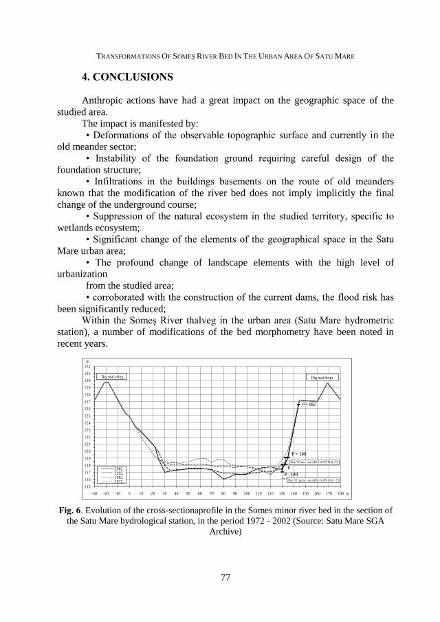
Within the Someș River thalveg in the urban area (Satu Mare hydrometric
station), a number of modifications of the bed morphometry have been noted in
recent years.
Fig. 6. Evolution of the cross-sectionaprofile in the Somes minor river bed in the section of
the Satu Mare hydrological station, in the period 1972 - 2002 (Source: Satu Mare SGA
Archive)
P - 100
0
P + 100
P + 850
Plan "O"mira cota ABS.118.070 M.N.-75
Plan "O" grafic cota ABS.116.070 M.N.- 75
115
116
117
118
119
120
121
122
123
124
125
126
127
128
129
130
131
132
-30 -20 -10 0 10 20 30 40 50 60 70 80 90 100 110 120 130 140 150 160 170 180
2002199219821972
Dig mal dreptDig mal stâng
m
m
C-O. MAREȘ
78
Someș' thalweg shows morphometric changes of the river bed, the
intensity and depth of the changes being surprised by the transverse profiles made
in the backyard's plane for 30 years.
Changes may have as cause:
• a subsidence process influenced by the descening area of Bodrog
(Hungary);
• a rinsing cycle of Someş;
• the influence of upstream storage lakes that retain a segment of
alluviums and change the natural drainage regime;
• the influence of upstream and downstream ballasts that cause slope
changes;
• river bed rectifications that have modified the average flow rate of river
water in the sector;
• the presence in the river bed of riprap and debris of former
decommissioned hydro-technical works that cause changes in the flowing stream
from the bed.
• the deepening of the thalweg may endanger the stability of hydro-
technical constructions (bridges, dikes).
It can be concluded that due to the action of the mentioned factors there are
morphological changes in the Someș River thalweg, the river, in the urban sector,
deepening its thalweg in its own alluvial deposits.
REFERENCES
1. Dancu, P, (2008), Apa Sătmarului - Un secol de istorie tehnologică, Edit. Dacia, Cluj
Napoca
2. Kovacs, M. C., (2005), Geografia agriculturii din Câmpia Someșului, Edit. Napoca
Star, Cluj Napoca
3. Radosav, D, Porumbăcean, C, (2016), Monografia Județului Satu Mare, Edit.,
Argonaut, Cluj Napoca
4. *** (1992), Geografia României IV, Edit. Academiei Române, București,
5. *** (2017), Arhiva SGA Satu Mare-ABAST, Cluj Napoca
6. *** (2009), Arhiva Consiliului Județean Satu Mare
7. *** (2018), Arhiva Muzeului Județean Satu Mare
8. *** (2017), Arhivele Naționale Satu Mare