Embed Size (px)
Citation preview

RISCURII CATASTROFE
Vol. VIII, Nr. 6/ 2009
Fenomene i procese climatice de risc
61
THE ABUNDANT PRECIPITATIONS IN THE PERIOD 22ND – 27TH OF JULY, 2008, FROM SUCEAVA COUNTY
AND THE SURROUNDING AREAS. CAUSES AND CONSEQUENCES
Diana BOSTAN, D. MIH IL , I. T NAS
ABSTRACT. - The abundant precipitations in the period 22nd – 27th of july, 2008, from Suceava county and the surrounding areas. Causes and consequences. Between 23-27.07.2008, on the territory of Suceava county and the neighbouring areas were registered prominent quantities of precipitations which produced exceptional flash floods in the interval 24.07 – 5.08.2008. The synoptic context which determined the abundant precipitations consisted in the presence of a coupling between a nucleus come from the Arabic Depression and a cold nucleus of altitude which persisted for a few days and had a retrograde evolution, from the north of the Black Sea to the north of Moldavia and Bucovina.The synoptic and orographic conditions from the specified areas led to large quantities of precipitations which fell in a short time in different stages. In a first stage, in the western side of Suceava county (in the hydrographic basin of the river Moldavia) fell abundant precipitations. After about 24 hours, this time in the east of the county, another wave of precipitations, even more abundant quantitatively, affected especially the hydrographic basins of Suceava and the superior Siret. The very large quantities of precipitations from the interval analysed (which culminated the value of 431,9l/m2 in Vicovu de Jos), broke out the apparition in the field of at least two exceptional flash floods, with a historical character. The evolution of the hydrometeorological events from these habitats, the production, in only 2-3 days, of two successive, extremely violent flash floods determined uncommon material losses.
Key words: torrential precipitations, flash floods, material losses.
1. General considerations
Suceava county is set in the north-east side of Romania and extends itself on a surface of 8553,5km2 (3,6% from the country surface). This overlaps itself to the East Carpathians (55%) and the Plateau of Suceava (47%), being characterized by a large variety of the physical-geographical (dense hydrographic system) and socio-economic cadre.
Num r dedicat conferin ei AERUL I APA COMPONENTE ALE MEDIULUI
20 -21 Martie 2009 CLUJ - NAPOCA

RISCURII CATASTROFE
Vol. VIII, Nr. 6/ 2009
Riscuri i catastrofe Victor Sorocovschi
62
2. The pluviometry, specific features and influences
The spatial-temporal variability of the dynamic nature factors, the altitude and the big fragmentation of the relief etc., often determine (V. Dornei-1912,
Cârlibaba-1938, Suceava-2005, Arbore-2006 etc.), in Suceava county, extreme pluviometric manifestations (large quantities of precipitations – over 200mm/24h).
3. The synoptic situation in the interval 22nd – 27th of July 2008
Starting from the day of July 22, 2008, at the ground, on a thalweg of the Arabic
Depression shows up a depressionary nucleus of 1005hPa in the basin of the Aegean Sea. During the following days (fig. 2 a), the pressure continued to decrease, the nucleus of 1005hPa extended itself all over the basin of the Black Sea, then, from July 27, 2008, this moved slowly over the Sea of Azov to Russia, our country territory getting out from under its influence (fig. 2 b).
In altitude, at 500hPa, showed up, from July 23, a closed nucleus with a centre on the south of Hungary, which evolved gradually over Serbia, the south of Romania, finally reaching the west of the Black Sea.
The nucleus formed in the thalweg of the Arabic Depression - with the afflux of moisture and warmth – correlated with the cold nucleus of altitude which manifested their presence during the 5 days from the last decade of the month of July,
determined the abundant precipitations that led to the record debits registered on the rivers Moldavia, Suceava, Siret and Prut.
Fig. 2 a. The synoptic situation from 24-25.07. 08
Fig. 2 b. The allotment of the air pressure at the ground and at the level of the 500hPa isobaric
surface above the east of Europe on the days of 26-27.VII.08 – after www.wetterzentrale.de
Num r dedicat conferin ei AERUL I APA COMPONENTE ALE MEDIULUI
20 -21 Martie 2009 CLUJ - NAPOCA
RISCURII CATASTROFE
Vol. VIII, Nr. 6/ 2009
Fenomene i procese climatice de risc
63
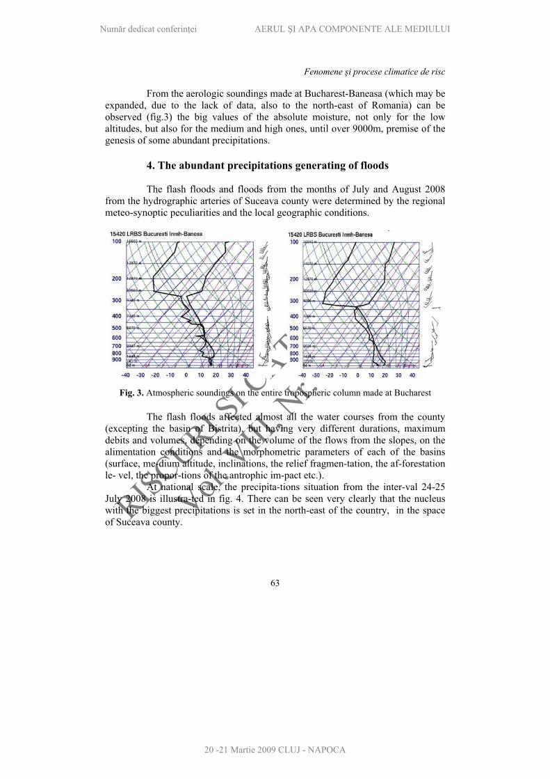
From the aerologic soundings made at Bucharest-Baneasa (which may be expanded, due to the lack of data, also to the north-east of Romania) can be observed (fig.3) the big values of the absolute moisture, not only for the low altitudes, but also for the medium and high ones, until over 9000m, premise of the genesis of some abundant precipitations.
4. The abundant precipitations generating of floods
The flash floods and floods from the months of July and August 2008 from the hydrographic arteries of Suceava county were determined by the regional meteo-synoptic peculiarities and the local geographic conditions.
Fig. 3. Atmospheric soundings on the entire tropospheric column made at Bucharest
The flash floods affected almost all the water courses from the county (excepting the basin of Bistrita), but having very different durations, maximum debits and volumes, depending on the volume of the flows from the slopes, on the alimentation conditions and the morphometric parameters of each of the basins (surface, me-dium altitude, inclinations, the relief fragmen-tation, the af-forestation le- vel, the propor-tions of the antrophic im-pact etc.).
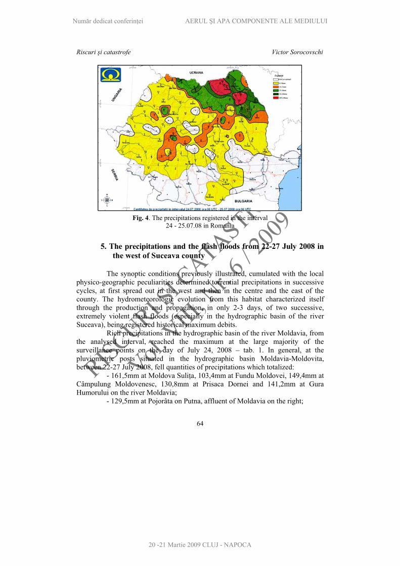
At national scale, the precipita-tions situation from the inter-val 24-25 July 2008 is illustra-ted in fig. 4. There can be seen very clearly that the nucleus with the biggest precipitations is set in the north-east of the country, in the space of Suceava county.
Num r dedicat conferin ei AERUL I APA COMPONENTE ALE MEDIULUI
20 -21 Martie 2009 CLUJ - NAPOCA
RISCURII CATASTROFE
Vol. VIII, Nr. 6/ 2009
Riscuri i catastrofe Victor Sorocovschi
64
Fig. 4. The precipitations registered in the interval 24 - 25.07.08 in Romania
5. The precipitations and the flash floods from 22-27 July 2008 in the west of Suceava county
The synoptic conditions previously illustrated, cumulated with the local physico-geographic peculiarities determined torrential precipitations in successive cycles, at first spread out in the west and then in the centre and the east of the county. The hydrometeorologic evolution from this habitat characterized itself through the production and propagation, in only 2-3 days, of two successive, extremely violent flash floods (especially in the hydrographic basin of the river Suceava), being registered historical maximum debits.
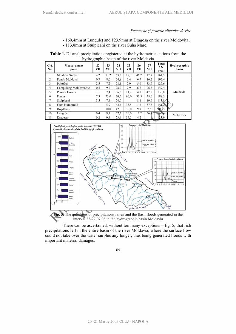
Rich precipitations in the hydrographic basin of the river Moldavia, from the analysed interval, reached the maximum at the large majority of the surveillance points on the day of July 24, 2008 – tab. 1. In general, at the pluviometric posts situated in the hydrographic basin Moldavia-Moldovita, between 22-27 July 2008, fell quantities of precipitations which totalized:
- 161,5mm at Moldova Suli a, 103,4mm at Fundu Moldovei, 149,4mm at Câmpulung Moldovenesc, 130,8mm at Prisaca Dornei and 141,2mm at Gura Humorului on the river Moldavia;
- 129,5mm at Pojorâta on Putna, affluent of Moldavia on the right;
Num r dedicat conferin ei AERUL I APA COMPONENTE ALE MEDIULUI
20 -21 Martie 2009 CLUJ - NAPOCA
RISCURII CATASTROFE
Vol. VIII, Nr. 6/ 2009
Fenomene i procese climatice de risc
65
- 169,4mm at Lungule and 123,9mm at Drago a on the river Moldovi a;- 113,8mm at Stulpicani on the river Suha Mare.
Table 1. Diurnal precipitations registered at the hydrometric stations from the hydrographic basin of the river Moldavia
Crt. No.
Measurement point
22VII
23VII
24VII
25VII
26VII
27VII
Total22-
27iul
Hydrographicbasin
1 Moldova Suli a 4,2 11,2 63,3 18,7 46,2 17,9 161,5 2 Fundu Moldovei 0,7 8,6 64,8 6,4 6,7 16,2 103,4 3 Pojorâta 2,5 7,2 78,1 2,9 5,0 33,9 129,6 4 Câmpulung Moldovenesc 0,5 9,7 98,2 7,9 6,8 26,3 149,4 5 Prisaca Dornei 1,1 7,4 56,3 14,2 4,0 47,8 130,8 6 Frasin 7,3 23,0 30,5 60,0 32,5 35,0 188,3 7 Stulpicani 3,5 7,4 74,9 8,1 19,9 113,8 8 Gura Humorului 5,9 62,4 33,5 1,6 37,8 141,2 9 Bogd ne ti 10,0 42,0 36,0 9,8 2,5 100,3
Moldavia
10 Lungule 0,4 9,1 57,3 30,0 16,2 56,4 169,4 11 Drago a 0,2 9,4 73,6 36,5 4,2 123,9
Moldovi a
Fig. 5. The quantities of precipitations fallen and the flash floods generated in the interval 22-27.07.08 in the hydrographic basin Moldavia
There can be ascertained, without too many exceptions – fig. 5, that rich precipitations fell in the entire basin of the river Moldavia, where the surface flow could not take over the water surplus any longer, thus being generated floods with important material damages.
Num r dedicat conferin ei AERUL I APA COMPONENTE ALE MEDIULUI
20 -21 Martie 2009 CLUJ - NAPOCA

RISCURII CATASTROFE
Vol. VIII, Nr. 6/ 2009
Riscuri i catastrofe Victor Sorocovschi
66
Also, in the superior hydrographic basin of the river Bistrita were registered significant local precipitations which exceeded the attention marks, but without uncommon effects.
6. The evolution of the precipitations registered in the eastern side of Suceava county in the period 22-27 July 2008
The wave with the biggest precipitations which affected the eastern side of the county (the hydrographic basins Suceava, omuz and Siret) in the analysed interval generated itself with a temporal postponement of 12-24 hours in comparison with the western and central sides of the administrative unit under investigation.
Table 2. Precipitations registered in the period 22-27 July 2008 at the pluviometric posts from the hydrographic basins of the rivers Suceava, omuz and Siret
TotalCrt. No.
Measurement point 22 23 24 25 26 27
22-27Hydrographic
basin1 Brodina 3,2 23,8 52,7 102,3 107,7 10,2 299,9 2 Vicovu de Jos 6,0 32,7 56,2 145,5 99,5 92,0 431,9 3 ibeni 8,9 58,1 55,6 23,2 27,6 173,4 4 I cani 0,1 8,6 51,1 74,4 19,8 154,0 5 Suceava 7,1 1,6 58,1 77,8 5,2 19,2 169,0
Suceava
6 Horodnic 8,3 73,4 85,0 24,1 1,2 192,0 Pozen 7 R d u i 5,2 7,4 65,0 75,4 45,4 3,8 202,2 Sucevi a8 Cacica 3,5 15,8 50,8 80,0 7,5 13,0 170,6 9 P rh u i 10,8 51,3 85,5 13,0 16,8 177,4
Solone
10 F lticeni 5,8 14,1 47,6 50,0 17,4 28,6 163,5 11 Dolhesti 0,2 10,5 28,2 73,6 27,5 3,8 143,8 12 Dolhasca 5,0 9,0 44,2 64,6 13,0 26,3 162,1
omuzulMare
13 Siret 13,5 36,6 37,9 16,3 71,6 175,9 14 Zvori tea 3,4 7,8 33,0 34,3 18,6 9,2 106,3 15 Hu ani 11,9 42,3 15,6 22,7 3,5 96,0 16 Adâncata 3,0 8,0 50,0 70,0 34,7 27,5 193,2 17 Fântânele 6,0 49,0 78,0 18,2 28,7 179,9
Siret
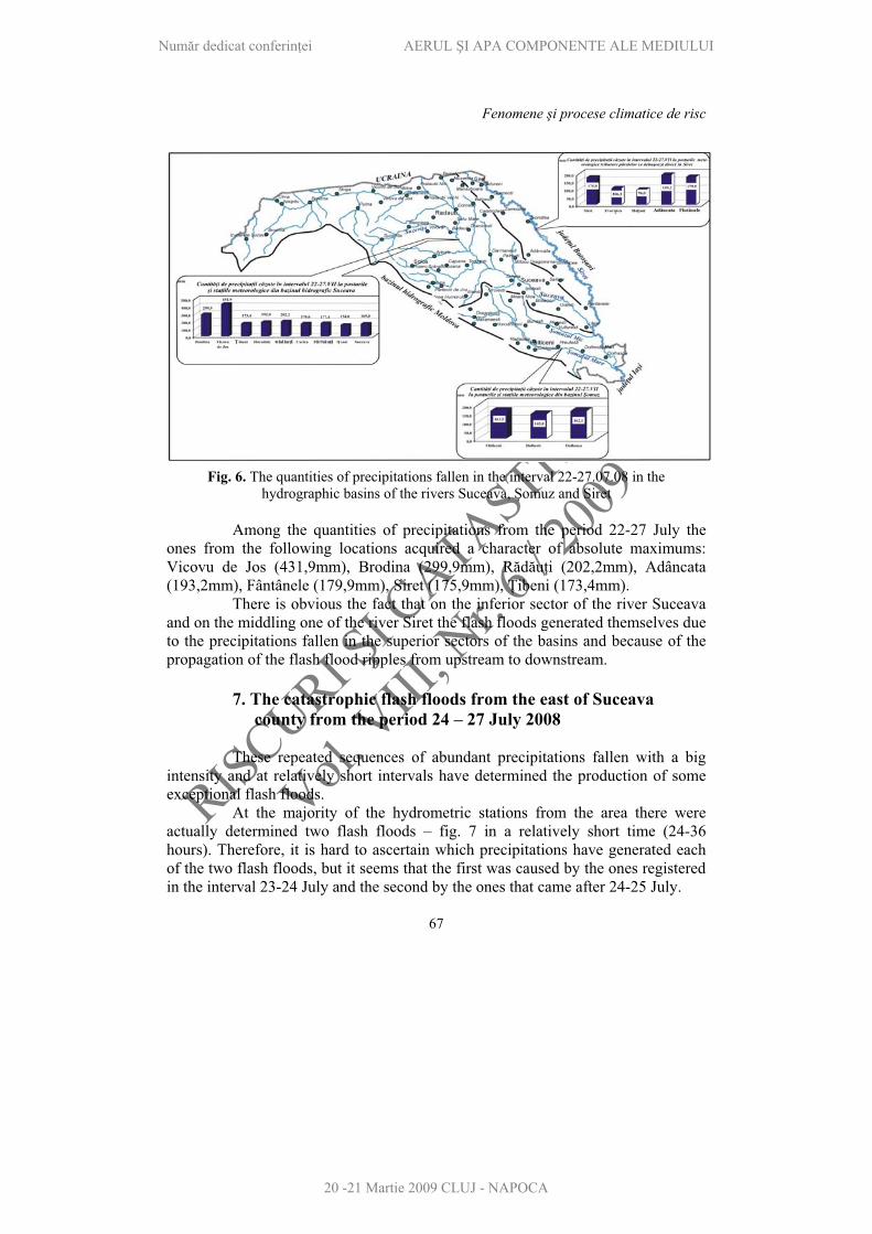
The pluviometric maximums generated themselves in the large majority of the pluviometric posts, from where we benefited of information on the date of 25th of July 2008. Cumulatively, in the 6 days rich in precipitations fell large quantities of water in all the observations points – tab. 2. From the pluviometric casuistry we are pointing out: - the 299,9 mm fallen at Brodina – on Suceava; - 431,9 mm at Vicovu de Jos – on Suceava; - 202,2 mm at R d u i – on Sucevi a; - 163,5 mm at F lticeni on omuzul Mare; 193,2 mm at Adâncata – in the basin of the Siret (table 2 and fig. 6).
Num r dedicat conferin ei AERUL I APA COMPONENTE ALE MEDIULUI
20 -21 Martie 2009 CLUJ - NAPOCA
RISCURII CATASTROFE
Vol. VIII, Nr. 6/ 2009
Fenomene i procese climatice de risc
67
Fig. 6. The quantities of precipitations fallen in the interval 22-27.07.08 in the hydrographic basins of the rivers Suceava, omuz and Siret
Among the quantities of precipitations from the period 22-27 July the ones from the following locations acquired a character of absolute maximums: Vicovu de Jos (431,9mm), Brodina (299,9mm), R d u i (202,2mm), Adâncata (193,2mm), Fântânele (179,9mm), Siret (175,9mm), ibeni (173,4mm).
There is obvious the fact that on the inferior sector of the river Suceava and on the middling one of the river Siret the flash floods generated themselves due to the precipitations fallen in the superior sectors of the basins and because of the propagation of the flash flood ripples from upstream to downstream.
7. The catastrophic flash floods from the east of Suceava county from the period 24 – 27 July 2008
These repeated sequences of abundant precipitations fallen with a big intensity and at relatively short intervals have determined the production of some exceptional flash floods.
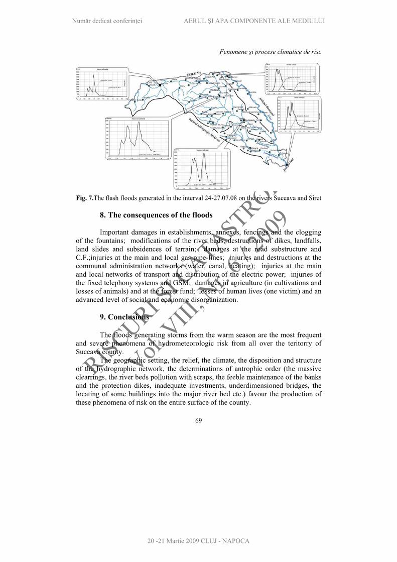
At the majority of the hydrometric stations from the area there were actually determined two flash floods – fig. 7 in a relatively short time (24-36 hours). Therefore, it is hard to ascertain which precipitations have generated each of the two flash floods, but it seems that the first was caused by the ones registered in the interval 23-24 July and the second by the ones that came after 24-25 July.
Num r dedicat conferin ei AERUL I APA COMPONENTE ALE MEDIULUI
20 -21 Martie 2009 CLUJ - NAPOCA

RISCURII CATASTROFE
Vol. VIII, Nr. 6/ 2009
Riscuri i catastrofe Victor Sorocovschi
68
Table 3. The maximum debits registered at the hydrometric stations from the superior hydrographic basin of the river Moldavia
Q. max. untill 2008 Q. max. 2008 The river The hydrometric station m3/s day/month/year m3/s Day/hour
Prisaca Dornei 304 VI 1972 274 24.07 / 5.00 MoldaviaGura Humorului 694 17.08.2002 664 26.VII / 20
Lungule 186 VII-1969 254 26.VII / 13.30 Moldovi aDrago a 463 VIII.2002 539 26.VII / 15-16
The precipitations fallen after the date of 27.07 2008 no longer have important hydrologic consequences. In the hydrographic basin Moldavia, on its affluent Moldovi a, at the hydrometric stations Lungule and Drago a were exceeded the maximum debits registered previously to the year 2008 – table 3.
Table 4. The maximum debits registered at the hydrometric stations from the hydrographic basins Suceava and Siret
The river The
hydrometric station
Q max. untill2008
(cm/s)
month/year Q max.
2008(cm/s)
day/hour
Brodina 325 VI 1969 465 26.07 / 16
ibeni 520 VI.1995 858966
25.07 / 1000
26.07 / 21- 27.07 / 1 Suceava
I cani 1354 VI.1969 16401946
25.07 / 16 27.07 / 4
Pozen Horodnic 108 VI.1975 104 26.07 / 16 Solone P rh u i 309 VII 2006 360 25. 07 / 600
Siret 1193 VII.1969 920 26.07 / 1-2 Siret Hu ani 866 VII.1969 672 27.07 / 8-10
The historical debits registered during a long observation (over 30 years) at some hydrometric stations from the hydrographic basin Suceava, as on the Siret too (middling and superior sectors), are illustrated in table 4. From table 4 we can observe that the maximum debits registered at the flash flood from 22-27 July 2008 (flash flood which continued in an attenuated form for a few days) exceeded, on Suceava and Solone , the maximum historical values registered in the previous interval. The hydrographs from the few hydrometric posts illustrated in fig. 7 (Brodina, Tibeni, Itcani – on Suceava; Siret and Lespezi – Ia i county – on Siret) are suggestive in reflecting the amplitude of the flash floods on these hydrographic arteries.
Num r dedicat conferin ei AERUL I APA COMPONENTE ALE MEDIULUI
20 -21 Martie 2009 CLUJ - NAPOCA
RISCURII CATASTROFE
Vol. VIII, Nr. 6/ 2009
Fenomene i procese climatice de risc
69
Fig. 7.The flash floods generated in the interval 24-27.07.08 on the rivers Suceava and Siret
8. The consequences of the floods
Important damages in establishments, annexes, fencings and the clogging of the fountains; modifications of the river beds, destructions of dikes, landfalls, land slides and subsidences of terrain; damages at the road substructure and C.F.;injuries at the main and local gas pipe-lines; injuries and destructions at the communal administration networks (water, canal, heating); injuries at the main and local networks of transport and distribution of the electric power; injuries of the fixed telephony systems and GSM; damages in agriculture (in cultivations and losses of animals) and at the forest fund; losses of human lives (one victim) and an advanced level of social and economic disorganization.
9. Conclusions
The floods generating storms from the warm season are the most frequent and severe phenomena of hydrometeorologic risk from all over the teritorry of Suceava county.
The geographic setting, the relief, the climate, the disposition and structure of the hydrographic network, the determinations of antrophic order (the massive clearrings, the river beds pollution with scraps, the feeble maintenance of the banks and the protection dikes, inadequate investments, underdimensioned bridges, the locating of some buildings into the major river bed etc.) favour the production of these phenomena of risk on the entire surface of the county.
Num r dedicat conferin ei AERUL I APA COMPONENTE ALE MEDIULUI
20 -21 Martie 2009 CLUJ - NAPOCA
RISCURII CATASTROFE
Vol. VIII, Nr. 6/ 2009
Riscuri i catastrofe Victor Sorocovschi
70
In the mountain sector fast floods are generated by the massive flows from the slopes and the reduced capacity of collecting the affluents.
The statistics of the last 15 years discloses the fact that, practically, each locality has been frequently affected by these phenomena which generate important damages, both to the citizens and to the economic operators from the forest sector and the sector of the wood primary processing, favouring, with the wind intensification, a large volume of fellings and the destruction of many forest roads.
There are also generated obstructions in the zone of the bridges and little bridges, cloggings and deviations of the river beds. Practically, there have been affected all the economic and social domains of the investigated territory. The measures regarding the control of these phenomena must be taken at once, without expecting the production of another similar phenomena, which, according to the statistics, will be more and more frequent.
REFERENCES
1. Mih il D., T nas I., Bostan Diana (2007), Precipita iile din seara de 30 iunie 2006 de la Arbore; cauze i consecin e, Lucr rile Seminarului Geografic Dimitrie Cantemir, Univ. ,,Al. I. Cuza”, Iasi,
2. Romanescu, Gh. (2003), Inunda iile-între natural i accidental, în volumul ,,Riscuri iCatastrofe”, Editor V. Sorocovschi, Edit. Casa C r ii de tiin , Cluj-Napoca.
* * * Date meteorologice i hidrologice preluate din fondul de date al S.G.A Suceava iD.A. Siret din Bac u,
* * *www.wetterzendrale.de
Num r dedicat conferin ei AERUL I APA COMPONENTE ALE MEDIULUI
20 -21 Martie 2009 CLUJ - NAPOCA