Embed Size (px)
Citation preview
ROAD SAFETY AUDIT
I-195 WESTPORT
MAJOR HIGHWAY MEDIAN
CROSS-OVER CRASHES
Prepared for
Prepared by MS Transportation Systems, Inc.
Framingham, Massachusetts
September 2008
ROAD SAFETY AUDIT
I-195 WESTPORT
MAJOR HIGHWAY MEDIAN CROSS-OVER CRASHES
September 2008
Prepared for
Massachusetts Highway Department
Prepared by
MS Transportation Systems, Inc. 300 Howard Street P.O. Box 967
Framingham, Massachusetts 01701 508-620-2832 508-620-6897 (fax)
www.mstransportationsystemsinc.com
I-195 Westport Median Cross-Over RSA
MS Transportation Systems, Inc. Page i
TABLE OF CONTENTS Page INTRODUCTION 1 RSA PROCESS 3 ANALYSIS 8 SUMMARY OF RSA FINDINGS/POTENTIAL ACTIONS 13 RECOMMENDATIONS 17 APPENDIX 20
I-195 Westport Road Safety Audit
MS Transportation Systems, Inc. Page 1
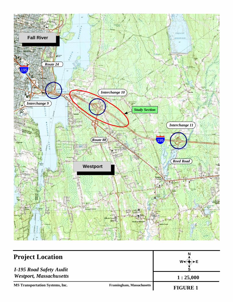
Introduction Lane departure crashes are one of the primary fatal crash types in Massachusetts. The Commonwealth exceeds the national average for the proportion of fatal lane departure crashes and was designated a lead state in lane departure crashes by the American Association of State Highway and Transportation Officials (AASHTO). The Massachusetts Highway Department (MassHighway) conducted a study of the problem and found that during 2002-2004, lane departure crashes accounted for 25 percent of all injury crashes and nearly half, 46 percent, of all fatal crashes. As part of the effort in implementing the safety plan and specifically reducing lane departure crashes, the MassHighway is completing a Road Safety Audit (RSA) Review Project specifically focused on median crossing (or median cross-over) crashes on its major highways. Road safety audits are a formal safety performance examination on existing or future roadways by an independent audit team. These specific audits are being conducted in locations where cross-over experience has been or has the potential to be of concern and where the RSA team has judged that factors exist that could affect the safety risk. During the audit, the RSA team works to identify opportunities for enhancing safety and to recommend specific enhancements intended to reduce median cross-over crashes and improve the overall safety along the highway. A RSA was conducted as part of this overall program for a 1.4 mile of I-195 in Westport (near Interchange No. 10 (Route 88)). Figure 1 shows the corridor section under study. The purpose of this I-195 Westport RSA is to identify current safety conditions on the highway section under study and to recommend a set of actions to address the identified issues. Recommendations contained in this report reflect the overall consent of the RSA team and do not necessarily reflect the official views of MassHighway.
Westport
195
195
Reed Road
Route 88
Project Location
I-195 Road Safety AuditWestport, MassachusettsMS Transportation Systems, Inc. Framingham, Massachusetts FIGURE 1
1 : 25,000
N
S
EW
Interchange 9
Interchange 11
Study Section
Route 24
Interchange 10
Fall River
I-195 Westport Road Safety Audit
MS Transportation Systems, Inc. Page 3
RSA Process The general process outlined in the guideline1 was essentially followed although with some minor variations to account for the project location being a high speed, high volume access controlled highway. The RSA team could not stop and gather as a group along the section without compromising traffic flow or the safety of the project. Thus, the RSA team members visited the site prior to the team meeting either individually or in smaller groups. A video recording of a drive-thru in both directions was collected by the RSA consultant and used at the meeting to review conditions as a group. Background material and plans were transmitted to the RSA consultant to compile and review prior to the initial RSA team meeting. Crash and traffic volume data were transmitted to RSA team members prior to the meeting as well. After the RSA team meeting was conducted, the RSA consultant gathered the input completed the analysis and prepared a draft document for team members to review. Data including summary crash records for the 2004-2007 period, two (2) detailed crash descriptions of cross-over crashes, and available record highway plans were obtained and reviewed by the RSA consultant. • RSA Team The following individuals participated in the I-195 Road Safety Audit:
Bill Travers, MassHighway District Maint. Lisa Schletzbaum, MassHighway, Safety Timothy White, FHWA Management Unit Jim Hadfield, SRPEDD Lt. Daniel Mulkern, MSP Paul Mission, SRPEDD Bonnie Polin, MassHighway, Safety Robert Gregory, MassHighway District Traffic Management Unit Alolade Campbell, MassHighway, District One Hwang, MassHighway Boston Project Development Highway Design William J. Scully, MS Transportation Systems (RSA Consultant)
Team members represented various agencies, disciplines and expertise. • RSA Meeting The RSA team met on May 8, 2008 at the MassHighway District 5 Office. The RSA team members listed above were present at the meeting. At the meeting, the RSA consultant provided a brief overview of the RSA process, a summary of the roadway section’s characteristics and the results of the descriptions of geometry, volume and
1 MS Transportation Systems, Inc., Road Safety Audits, Median Cross-Over Crashes, Audit Guidelines,
Prepared for MassHighway, October 2007.
I-195 Westport Road Safety Audit
MS Transportation Systems, Inc. Page 4
crash data and the field visit observations. The video record of the I-195, taken while driving the corridor was viewed by the team. During and following the video, additional discussions related to the possible factors related to the cross-median crashes and possible solutions to prevent or alleviate similar characteristics in the future. The RSA team provided input on the background, supporting data and the key items observed in the field and those items that were listed on the RSA Median Cross-Over Prompt List. Key items noted at the meeting included the following:
High travel speeds were noticeable. The Route 24 southbound to I-195 eastbound occurs in the left lane (or fast)
leaving little or no notice given to Route 24 southbound motorists. The median section (about ¾ mile in length) east of the Route 88 interchange
is flatter and more prone to crossing. Speeding and driver behavior continues to be a major issue. The condition of the paved “official” cross-overs (3) were noted in poor
condition – the question of signing the cross-over encourage inappropriate usage.
Crash data suggests most crashes are not cross-median related – other issues appear to contribute to crash characteristics.
Following the RSA meeting, the RSA consultant compiled the information, completed the analysis and circulated the draft report to team members. • Analysis Procedures The RSA analysis generally followed the procedure described in the previously referenced Guideline with some variations and also took into consideration the methods published by the Federal Highway Administration2 and those included in training materials3. The basic tasks included:
• Obtaining and reviewing crash and other traffic characteristic data and available record plans.
• Conducting site reconnaissance and collecting a current record of condition via photos and video,
• Identifying potentially hazardous issues, and • Identifying and evaluating potential actions to address the noted issues.
2 Federal Highway Administration, FHWA Road Safety Audit Guidelines, Publication No. FHWA SA-06-06,
Washington, D.C., 2006. 3 Federal Highway Administration, Resource Center, Road Safety Audits Mini-Workshop, Jeffrey Shaw, PE,
PTOE, presented to New England ITE Section, September 19, 2006.
I-195 Westport Road Safety Audit
MS Transportation Systems, Inc. Page 5
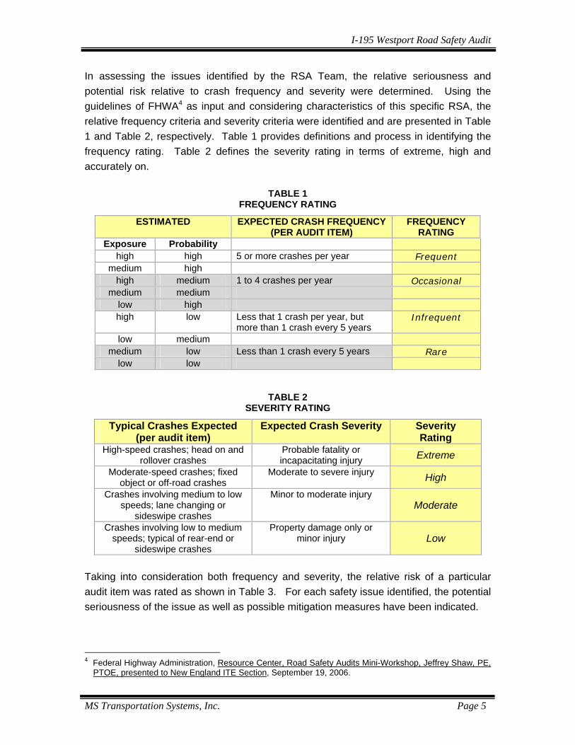
In assessing the issues identified by the RSA Team, the relative seriousness and potential risk relative to crash frequency and severity were determined. Using the guidelines of FHWA4 as input and considering characteristics of this specific RSA, the relative frequency criteria and severity criteria were identified and are presented in Table 1 and Table 2, respectively. Table 1 provides definitions and process in identifying the frequency rating. Table 2 defines the severity rating in terms of extreme, high and accurately on.
TABLE 1 FREQUENCY RATING
ESTIMATED EXPECTED CRASH FREQUENCY (PER AUDIT ITEM)
FREQUENCY RATING
Exposure Probability high high 5 or more crashes per year Frequent
medium high high medium 1 to 4 crashes per year Occasional
medium medium low high high low Less that 1 crash per year, but
more than 1 crash every 5 years Infrequent
low medium medium low Less than 1 crash every 5 years Rare
low low
TABLE 2 SEVERITY RATING
Typical Crashes Expected (per audit item)
Expected Crash Severity Severity Rating
High-speed crashes; head on and rollover crashes
Probable fatality or incapacitating injury Extreme
Moderate-speed crashes; fixed object or off-road crashes
Moderate to severe injury High
Crashes involving medium to low speeds; lane changing or
sideswipe crashes
Minor to moderate injury Moderate
Crashes involving low to medium speeds; typical of rear-end or
sideswipe crashes
Property damage only or minor injury Low
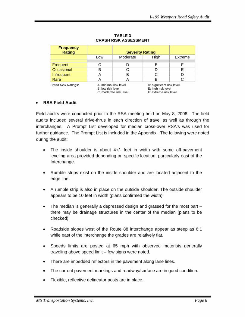
Taking into consideration both frequency and severity, the relative risk of a particular audit item was rated as shown in Table 3. For each safety issue identified, the potential seriousness of the issue as well as possible mitigation measures have been indicated.
4 Federal Highway Administration, Resource Center, Road Safety Audits Mini-Workshop, Jeffrey Shaw, PE,
PTOE, presented to New England ITE Section, September 19, 2006.
I-195 Westport Road Safety Audit
MS Transportation Systems, Inc. Page 6
TABLE 3
CRASH RISK ASSESSMENT Frequency
Rating
Severity Rating
Low Moderate High Extreme Frequent C D E F Occasional B C D E Infrequent A B C D Rare A A B C
Crash Risk Ratings: A: minimal risk level D: significant risk level B: low risk level E: high risk level C: moderate risk level F: extreme risk level
• RSA Field Audit Field audits were conducted prior to the RSA meeting held on May 8, 2008. The field audits included several drive-thrus in each direction of travel as well as through the interchanges. A Prompt List developed for median cross-over RSA’s was used for further guidance. The Prompt List is included in the Appendix. The following were noted during the audit:
• The inside shoulder is about 4+/- feet in width with some off-pavement leveling area provided depending on specific location, particularly east of the Interchange.
• Rumble strips exist on the inside shoulder and are located adjacent to the edge line.
• A rumble strip is also in place on the outside shoulder. The outside shoulder appears to be 10 feet in width (plans confirmed the width).
• The median is generally a depressed design and grassed for the most part – there may be drainage structures in the center of the median (plans to be checked).
• Roadside slopes west of the Route 88 interchange appear as steep as 6:1
while east of the interchange the grades are relatively flat.
• Speeds limits are posted at 65 mph with observed motorists generally traveling above speed limit – few signs were noted.
• There are imbedded reflectors in the pavement along lane lines.
• The current pavement markings and roadway/surface are in good condition.
• Flexible, reflective delineator posts are in place.
I-195 Westport Road Safety Audit
MS Transportation Systems, Inc. Page 7
• Advance notice to motorists of the Route 88 interchange via signage is provided approximately one mile prior to the interchange.
• There is no lighting in the vicinity of the interchange.
• The two lane Route 88 northbound ramp to I-195 westbound has a long
straight section prior to a relatively sharp curve at I-195 without any substantive guidance. This was noted as a high volume movement, particularly during the summer, as Route 88 provides access to the ocean and state park.
• The two lane ramp begins its transition to a single lane near the curve and
then into a merge area on I-195.
I-195 Westport Road Safety Audit
MS Transportation Systems, Inc. Page 8
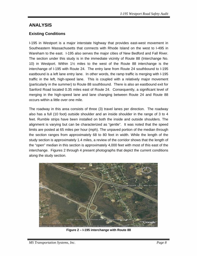
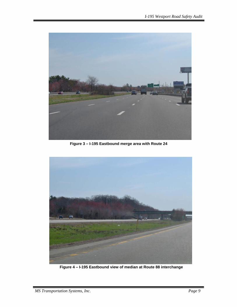
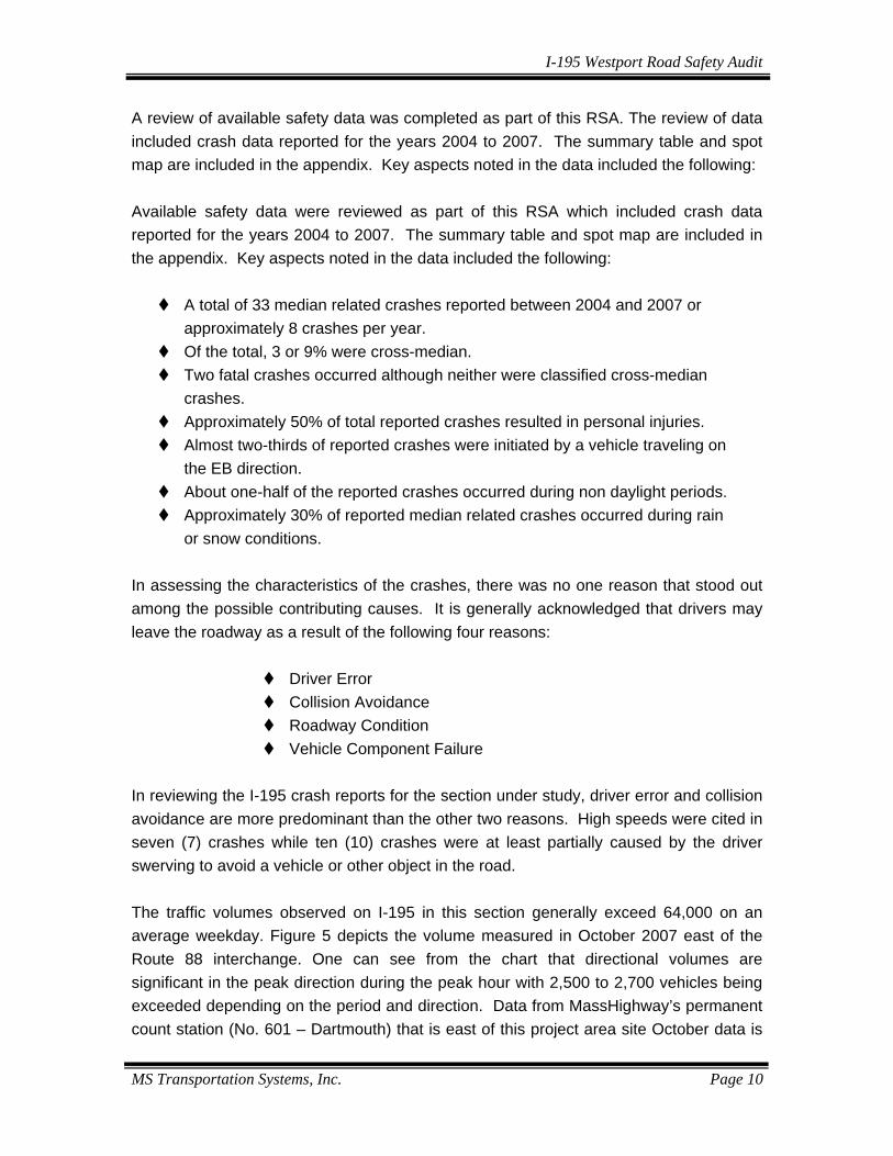
ANALYSIS Existing Conditions I-195 in Westport is a major interstate highway that provides east-west movement in Southeastern Massachusetts that connects with Rhode Island on the west to I-495 in Wareham to the east. I-195 also serves the major cities of New Bedford and Fall River. The section under this study is in the immediate vicinity of Route 88 (Interchange No. 10) in Westport. Within 1½ miles to the west of the Route 88 interchange is the interchange of I-195 with Route 24. The entry lane from Route 24 southbound to I-195 eastbound is a left lane entry lane. In other words, the ramp traffic is merging with I-195 traffic in the left, high-speed lane. This is coupled with a relatively major movement (particularly in the summer) to Route 88 southbound. There is also an eastbound exit for Sanford Road located 0.35 miles east of Route 24. Consequently, a significant level of merging in the high-speed lane and lane changing between Route 24 and Route 88 occurs within a little over one mile. The roadway in this area consists of three (3) travel lanes per direction. The roadway also has a full (10 foot) outside shoulder and an inside shoulder in the range of 3 to 4 feet. Rumble strips have been installed on both the inside and outside shoulders. The alignment is varying but can be characterized as “gentle”. It was noted that the speed limits are posted at 65 miles per hour (mph). The unpaved portion of the median through the section ranges from approximately 68 to 80 feet in width. While the length of the study section is approximately 1.4 miles, a review of the corridor shows that the length of the “open” median in this section is approximately 4,000 feet with most of this east of the interchange. Figures 2 through 4 present photographs that depict the current conditions along the study section.
Figure 2 – I-195 interchange with Route 88
I-195 Westport Road Safety Audit
MS Transportation Systems, Inc. Page 9
Figure 3 – I-195 Eastbound merge area with Route 24
Figure 4 – I-195 Eastbound view of median at Route 88 interchange
I-195 Westport Road Safety Audit
MS Transportation Systems, Inc. Page 10
A review of available safety data was completed as part of this RSA. The review of data included crash data reported for the years 2004 to 2007. The summary table and spot map are included in the appendix. Key aspects noted in the data included the following: Available safety data were reviewed as part of this RSA which included crash data reported for the years 2004 to 2007. The summary table and spot map are included in the appendix. Key aspects noted in the data included the following:
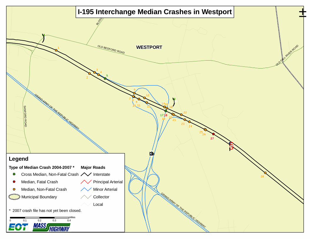
A total of 33 median related crashes reported between 2004 and 2007 or approximately 8 crashes per year.
Of the total, 3 or 9% were cross-median. Two fatal crashes occurred although neither were classified cross-median
crashes. Approximately 50% of total reported crashes resulted in personal injuries. Almost two-thirds of reported crashes were initiated by a vehicle traveling on
the EB direction. About one-half of the reported crashes occurred during non daylight periods. Approximately 30% of reported median related crashes occurred during rain
or snow conditions. In assessing the characteristics of the crashes, there was no one reason that stood out among the possible contributing causes. It is generally acknowledged that drivers may leave the roadway as a result of the following four reasons:
Driver Error Collision Avoidance Roadway Condition Vehicle Component Failure
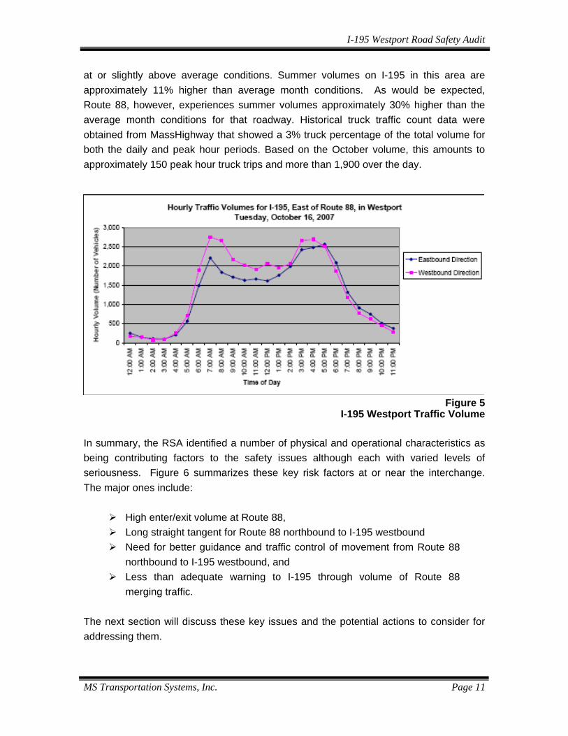
In reviewing the I-195 crash reports for the section under study, driver error and collision avoidance are more predominant than the other two reasons. High speeds were cited in seven (7) crashes while ten (10) crashes were at least partially caused by the driver swerving to avoid a vehicle or other object in the road. The traffic volumes observed on I-195 in this section generally exceed 64,000 on an average weekday. Figure 5 depicts the volume measured in October 2007 east of the Route 88 interchange. One can see from the chart that directional volumes are significant in the peak direction during the peak hour with 2,500 to 2,700 vehicles being exceeded depending on the period and direction. Data from MassHighway’s permanent count station (No. 601 – Dartmouth) that is east of this project area site October data is
I-195 Westport Road Safety Audit
MS Transportation Systems, Inc. Page 11
at or slightly above average conditions. Summer volumes on I-195 in this area are approximately 11% higher than average month conditions. As would be expected, Route 88, however, experiences summer volumes approximately 30% higher than the average month conditions for that roadway. Historical truck traffic count data were obtained from MassHighway that showed a 3% truck percentage of the total volume for both the daily and peak hour periods. Based on the October volume, this amounts to approximately 150 peak hour truck trips and more than 1,900 over the day.
Figure 5 I-195 Westport Traffic Volume
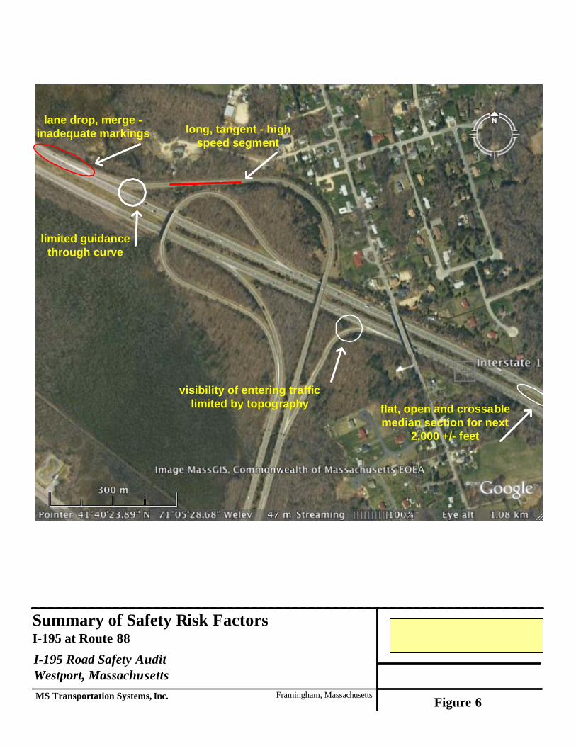
In summary, the RSA identified a number of physical and operational characteristics as being contributing factors to the safety issues although each with varied levels of seriousness. Figure 6 summarizes these key risk factors at or near the interchange. The major ones include:
High enter/exit volume at Route 88, Long straight tangent for Route 88 northbound to I-195 westbound Need for better guidance and traffic control of movement from Route 88
northbound to I-195 westbound, and Less than adequate warning to I-195 through volume of Route 88
merging traffic. The next section will discuss these key issues and the potential actions to consider for addressing them.
long, tangent - highspeed segment
lane drop, merge -inadequate markings
Summary of Safety Risk FactorsI-195 at Route 88I-195 Road Safety AuditWestport, MassachusettsMS Transportation Systems, Inc. Framingham, Massachusetts
Figure 6
limited guidancethrough curve
visibility of entering trafficlimited by topography flat, open and crossable
median section for next2,000 +/- feet
I-195 Westport Road Safety Audit
MS Transportation Systems, Inc. Page 13
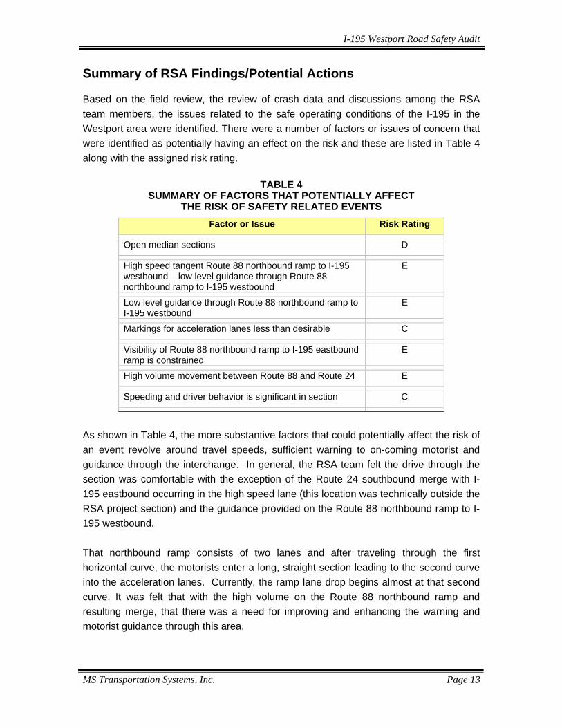
Summary of RSA Findings/Potential Actions Based on the field review, the review of crash data and discussions among the RSA team members, the issues related to the safe operating conditions of the I-195 in the Westport area were identified. There were a number of factors or issues of concern that were identified as potentially having an effect on the risk and these are listed in Table 4 along with the assigned risk rating.
TABLE 4 SUMMARY OF FACTORS THAT POTENTIALLY AFFECT
THE RISK OF SAFETY RELATED EVENTS
Factor or Issue Risk Rating
Open median sections D
High speed tangent Route 88 northbound ramp to I-195 westbound – low level guidance through Route 88 northbound ramp to I-195 westbound
E
Low level guidance through Route 88 northbound ramp to I-195 westbound
E
Markings for acceleration lanes less than desirable C
Visibility of Route 88 northbound ramp to I-195 eastbound ramp is constrained
E
High volume movement between Route 88 and Route 24 E
Speeding and driver behavior is significant in section C
As shown in Table 4, the more substantive factors that could potentially affect the risk of an event revolve around travel speeds, sufficient warning to on-coming motorist and guidance through the interchange. In general, the RSA team felt the drive through the section was comfortable with the exception of the Route 24 southbound merge with I-195 eastbound occurring in the high speed lane (this location was technically outside the RSA project section) and the guidance provided on the Route 88 northbound ramp to I-195 westbound. That northbound ramp consists of two lanes and after traveling through the first horizontal curve, the motorists enter a long, straight section leading to the second curve into the acceleration lanes. Currently, the ramp lane drop begins almost at that second curve. It was felt that with the high volume on the Route 88 northbound ramp and resulting merge, that there was a need for improving and enhancing the warning and motorist guidance through this area.
I-195 Westport Road Safety Audit
MS Transportation Systems, Inc. Page 14
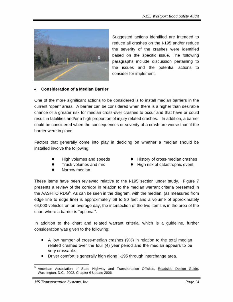
Suggested actions identified are intended to reduce all crashes on the I-195 and/or reduce the severity of the crashes were identified based on the specific issue. The following paragraphs include discussion pertaining to the issues and the potential actions to consider for implement.
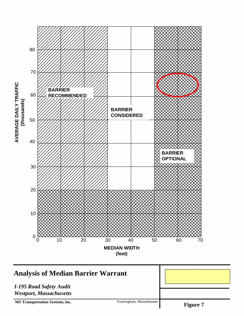
• Consideration of a Median Barrier One of the more significant actions to be considered is to install median barriers in the current “open” areas. A barrier can be considered when there is a higher than desirable chance or a greater risk for median cross-over crashes to occur and that have or could result in fatalities and/or a high proportion of injury related crashes. In addition, a barrier could be considered when the consequences or severity of a crash are worse than if the barrier were in place. Factors that generally come into play in deciding on whether a median should be installed involve the following:
High volumes and speeds Truck volumes and mix Narrow median
History of cross-median crashes High risk of catastrophic event
These items have been reviewed relative to the I-195 section under study. Figure 7 presents a review of the corridor in relation to the median warrant criteria presented in the AASHTO RDG5. As can be seen in the diagram, with the median (as measured from edge line to edge line) is approximately 68 to 80 feet and a volume of approximately 64,000 vehicles on an average day, the intersection of the two items is in the area of the chart where a barrier is “optional”. In addition to the chart and related warrant criteria, which is a guideline, further consideration was given to the following:
A low number of cross-median crashes (9%) in relation to the total median related crashes over the four (4) year period and the median appears to be very crossable.
Driver comfort is generally high along I-195 through interchange area.
5 American Association of State Highway and Transportation Officials, Roadside Design Guide,
Washington, D.C., 2002, Chapter 6 Update 2006.
Analysis of Median Barrier Warrant
I-195 Road Safety AuditWestport, MassachusettsMS Transportation Systems, Inc. Framingham, Massachusetts
BARRIERRECOMMENDED
BARRIERCONSIDERED
BARRIEROPTIONAL
MEDIAN WIDTH(feet)
AVE
RA
GE
DA
ILY
TRA
FFIC
(thou
sand
s)
80
70
60
50
40
30
20
10
00 10 20 30 40 50 60 70
Figure 7

I-195 Westport Road Safety Audit
MS Transportation Systems, Inc. Page 16
Consequently, based on the analysis of the data, the field drive-thru and discussion of the conditions by the RSA team members, it was concluded by the RSA team that at this time, the median itself did not require barrier treatment at this time but could be delineated better. As discussed in the AASHTO guide, where median widths exceed 50 feet, a “barrier is not normally considered except in special circumstances such as a location with a significant history of cross-median crashes”. Although this study section has experienced three (3) cross-median crashes over the study period, there have been frequent occurrences of median entries with two of the median entries resulting in fatalities. While the evaluation showed a barrier to be “optional”, the median is 80 feet or less and considered crossable in both east and west of the interchange. Consequently, the study section is recommended for monitoring and if the frequency cross-median crashes increase a barrier could be reconsidered. Other actions should be considered to address the noted risk factors. These are outlined in the next section.
I-195 Westport Road Safety Audit
MS Transportation Systems, Inc. Page 17
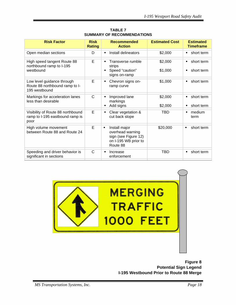
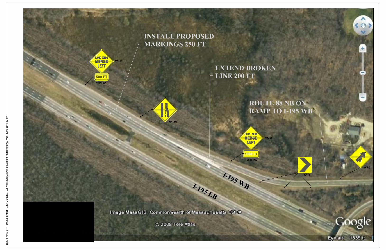
Recommendations As a result of the RSA analysis and team input, a set of recommendations have been identified and are summarized in Table 5. These actions are intended to reduce the chance of cross-median crashes, reduce the severity of all crashes and improve the overall safety condition of this section of I-195 in Westport. Identified in the table in addition to the risk factor and recommended action are the estimated costs and potential timeframe (i.e. short (0-1 year), medium (1-3 years) and long (>3 years)). The major suggestions for improvement for the I-195 Westport section of road under study focused on the definition and guidance of the Route 88 on-ramps to both the eastbound and westbound directions of flow. The recommended actions are also intended to provide improved advance warning to motorists of merging traffic and improved guidance for the Route 88 northbound to I-195 westbound movement. Visibility of the Route 88 northbound on-ramp to I-195 eastbound can be improved by cutting back the slope and vegetation at the inside end of the ramp. There are several risk factors in relation to the Route 88 northbound ramp to I-195 westbound movement that can be addressed through markings and signage. It is recommended that a new overhead caution sign be placed on I-195 westbound approximately ½ mile prior to the interchange. Figure 8 illustrates a potential legend for the sign. At the end of the on-ramp, chevron signs should be placed along the curve. If signage proves inadequate in the future, a fixed barrier may be the long term solution to prevent any motorists from “missing” the curve and entering the I-195 mainline at a 90° angle and potentially crossing the median. Speed “caution” reminders should also be placed on the straight section of the on-ramp. Finally, improved markings for the acceleration lanes/lane drop section of the on-ramp should be provided. An example of the markings and signage are illustrated in Figure 9. Flexible delineator posts can be installed to improve the visibility of the roadway and median. The final suggestion includes increased enforcement of speeds and inappropriate lane changing in this “zone” between Route 88 and Route 24.
I-195 Westport Road Safety Audit
MS Transportation Systems, Inc. Page 18
TABLE 7 SUMMARY OF RECOMMENDATIONS
Risk Factor Risk
Rating Recommended
Action Estimated Cost Estimated
Timeframe Open median sections D Install delineators $2,000 short term
High speed tangent Route 88 northbound ramp to I-195 westbound
E Transverse rumble strips
Speed “caution” signs on-ramp
$2,000
$1,000
short term short term
Low level guidance through Route 88 northbound ramp to I-195 westbound
E Chevron signs on-ramp curve
$1,000 short term
Markings for acceleration lanes less than desirable
C Improved lane markings
Add signs
$2,000
$2,000
short term short term
Visibility of Route 88 northbound ramp to I-195 eastbound ramp is poor
E Clear vegetation & cut back slope
TBD medium term
High volume movement between Route 88 and Route 24
E Install major overhead warning sign (see Figure 12) on I-195 WB prior to Route 88
$20,000 short term
Speeding and driver behavior is significant in sections
C Increase enforcement
TBD short term
Figure 8 Potential Sign Legend
I-195 Westbound Prior to Route 88 Merge
I-195 Westport Road Safety Audit
MS Transportation Systems, Inc. Page 20
Appendix
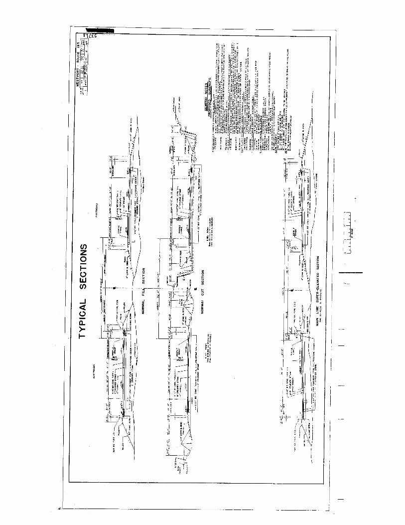
• RSA Meeting Agenda • RSA Team Contact List • Median Crash Diagram • Crash Data • Traffic Volume Data • Typical Cross-Section
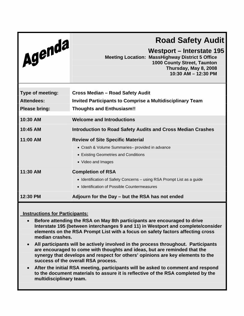
Road Safety Audit Westport – Interstate 195
Meeting Location: MassHighway District 5 Office 1000 County Street, Taunton
Thursday, May 8, 2008 10:30 AM – 12:30 PM
Type of meeting: Cross Median – Road Safety Audit Attendees: Invited Participants to Comprise a Multidisciplinary Team Please bring: Thoughts and Enthusiasm!!
10:30 AM Welcome and Introductions
10:45 AM Introduction to Road Safety Audits and Cross Median Crashes
11:00 AM Review of Site Specific Material • Crash & Volume Summaries– provided in advance
• Existing Geometries and Conditions
• Video and Images
11:30 AM Completion of RSA • Identification of Safety Concerns – using RSA Prompt List as a guide
• Identification of Possible Countermeasures
12:30 PM Adjourn for the Day – but the RSA has not ended
Instructions for Participants:
• Before attending the RSA on May 8th participants are encouraged to drive Interstate 195 (between interchanges 9 and 11) in Westport and complete/consider elements on the RSA Prompt List with a focus on safety factors affecting cross median crashes.
• All participants will be actively involved in the process throughout. Participants are encouraged to come with thoughts and ideas, but are reminded that the synergy that develops and respect for others’ opinions are key elements to the success of the overall RSA process.
• After the initial RSA meeting, participants will be asked to comment and respond to the document materials to assure it is reflective of the RSA completed by the multidisciplinary team.
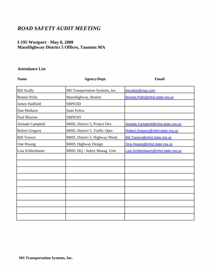
Name Agency/Dept. Email
Bill Scully MS Transportation Systems, Inc. [email protected]
Bonnie Polin MassHighway, Boston [email protected]
James Hadfield SRPEDD
Dan Mulkern State Police
Paul Mission SRPEDD
Alolade Campbell MHD, District 5, Project Dev. [email protected]
Robert Gregory MHD, District 5, Traffic Oper. [email protected]
Bill Travers MHD, District 5, Highway Maint. [email protected]
One Hwang MHD, Highway Design [email protected]
Lisa Schletzbaum MHD, HQ - Safety Manag. Unit [email protected]
ROAD SAFETY AUDIT MEETING
Attendance List
MassHighway District 5 Offices, Taunton MAI-195 Westport - May 8, 2008
MS Transportation Systems, Inc.
")
")
")
")
")
")
")
")
")
")
")
")
")
")
")
")
")
")
")
")
")
")
")
")
")
")
")
")
")
")
")
")
")
")
")
")
")
")
")
§̈¦195
£¤88
16
WESTPORT
GRAND ARMY OF THE REPUBLIC HIGHWAY
GRAND ARMY OF THE REPUBLIC HIGHWAY
OLD BEDFORD ROAD
SAN
FOR
D R
OAD
BLOSS
OM R
OAD
OLD FALL RIVER R
OAD
5
1718
27
1
7 8
4
9
6
2
3
19
2423
10 141513
22
2625
21
12
11
28
20
9
10
±I-195 Interchange Median Crashes in Westport
LegendType of Median Crash 2004-2007 *
Cross Median, Non-Fatal Crash
Median, Fatal Crash
Median, Non-Fatal Crash
Municipal Boundary
Major RoadsInterstate
Principal Arterial
Minor Arterial
Collector
Local
0 0.1 0.2 0.3 0.4Miles
* 2007 crash file has not yet been closed.
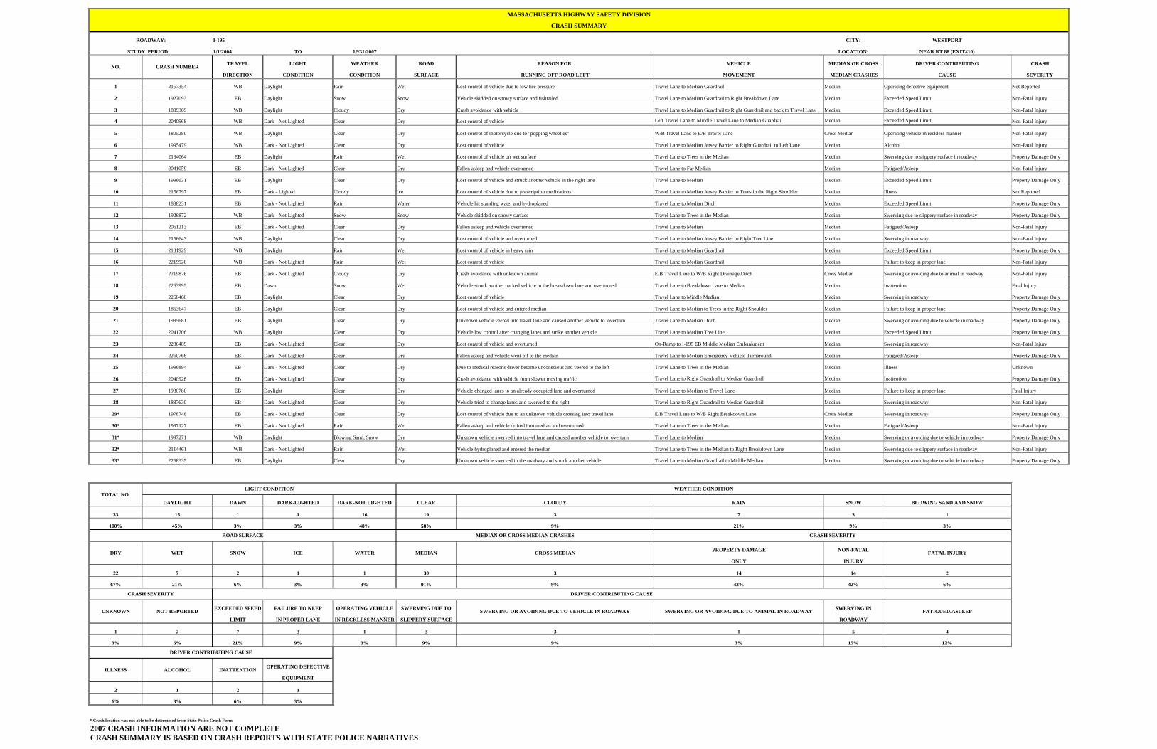
I-195 CITY: WESTPORT
1/1/2004 TO 12/31/2007 LOCATION: NEAR RT 88 (EXIT#10)
TRAVEL LIGHT WEATHER ROAD REASON FOR VEHICLE MEDIAN OR CROSS DRIVER CONTRIBUTING CRASH
DIRECTION CONDITION CONDITION SURFACE RUNNING OFF ROAD LEFT MOVEMENT MEDIAN CRASHES CAUSE SEVERITY
1 2157354 WB Daylight Rain Wet Lost control of vehicle due to low tire pressure Travel Lane to Median Guardrail Median Operating defective equipment Not Reported
2 1927093 EB Daylight Snow Snow Vehicle skidded on snowy surface and fishtailed Travel Lane to Median Guardrail to Right Breakdown Lane Median Exceeded Speed Limit Non-Fatal Injury
3 1899369 WB Daylight Cloudy Dry Crash avoidance with vehicle Travel Lane to Median Guardrail to Right Guardrail and back to Travel Lane Median Exceeded Speed Limit Non-Fatal Injury
4 2040968 WB Dark - Not Lighted Clear Dry Lost control of vehicle Left Travel Lane to Middle Travel Lane to Median Guardrail Median Exceeded Speed Limit Non-Fatal Injury
5 1805280 WB Daylight Clear Dry Lost control of motorcycle due to "popping wheelies" W/B Travel Lane to E/B Travel Lane Cross Median Operating vehicle in reckless manner Non-Fatal Injury
6 1995479 WB Dark - Not Lighted Clear Dry Lost control of vehicle Travel Lane to Median Jersey Barrier to Right Guardrail to Left Lane Median Alcohol Non-Fatal Injury
7 2134064 EB Daylight Rain Wet Lost control of vehicle on wet surface Travel Lane to Trees in the Median Median Swerving due to slippery surface in roadway Property Damage Only
8 2041059 EB Dark - Not Lighted Clear Dry Fallen asleep and vehicle overturned Travel Lane to Far Median Median Fatigued/Asleep Non-Fatal Injury
9 1996631 EB Daylight Clear Dry Lost control of vehicle and struck another vehicle in the right lane Travel Lane to Median Median Exceeded Speed Limit Property Damage Only
10 2156797 EB Dark - Lighted Cloudy Ice Lost control of vehicle due to prescription medications Travel Lane to Median Jersey Barrier to Trees in the Right Shoulder Median Illness Not Reported
11 1888231 EB Dark - Not Lighted Rain Water Vehicle hit standing water and hydroplaned Travel Lane to Median Ditch Median Exceeded Speed Limit Property Damage Only
12 1926872 WB Dark - Not Lighted Snow Snow Vehicle skidded on snowy surface Travel Lane to Trees in the Median Median Swerving due to slippery surface in roadway Property Damage Only
13 2051213 EB Dark - Not Lighted Clear Dry Fallen asleep and vehicle overturned Travel Lane to Median Median Fatigued/Asleep Non-Fatal Injury
14 2156643 WB Daylight Clear Dry Lost control of vehicle and overturned Travel Lane to Median Jersey Barrier to Right Tree Line Median Swerving in roadway Non-Fatal Injury
15 2131929 WB Daylight Rain Wet Lost control of vehicle in heavy rain Travel Lane to Median Guardrail Median Exceeded Speed Limit Property Damage Only
16 2219928 WB Dark - Not Lighted Rain Wet Lost control of vehicle Travel Lane to Median Guardrail Median Failure to keep in proper lane Non-Fatal Injury
17 2219876 EB Dark - Not Lighted Cloudy Dry Crash avoidance with unknown animal E/B Travel Lane to W/B Right Drainage Ditch Cross Median Swerving or avoiding due to animal in roadway Non-Fatal Injury
18 2263995 EB Dawn Snow Wet Vehicle struck another parked vehicle in the breakdown lane and overturned Travel Lane to Breakdown Lane to Median Median Inattention Fatal Injury
19 2268468 EB Daylight Clear Dry Lost control of vehicle Travel Lane to Middle Median Median Swerving in roadway Property Damage Only
20 1863647 EB Daylight Clear Dry Lost control of vehicle and entered median Travel Lane to Median to Trees in the Right Shoulder Median Failure to keep in proper lane Property Damage Only
21 1995681 EB Daylight Clear Dry Unknown vehicle veered into travel lane and caused another vehicle to overturn Travel Lane to Median Ditch Median Swerving or avoiding due to vehicle in roadway Property Damage Only
22 2041706 WB Daylight Clear Dry Vehicle lost control after changing lanes and strike another vehicle Travel Lane to Median Tree Line Median Exceeded Speed Limit Property Damage Only
23 2236489 EB Dark - Not Lighted Clear Dry Lost control of vehicle and overturned On-Ramp to I-195 EB Middle Median Embankment Median Swerving in roadway Non-Fatal Injury
24 2260766 EB Dark - Not Lighted Clear Dry Fallen asleep and vehicle went off to the median Travel Lane to Median Emergency Vehicle Turnaround Median Fatigued/Asleep Property Damage Only
25 1996894 EB Dark - Not Lighted Clear Dry Due to medical reasons driver became unconscious and veered to the left Travel Lane to Trees in the Median Median Illness Unknown
26 2040928 EB Dark - Not Lighted Clear Dry Crash avoidance with vehicle from slower moving traffic Travel Lane to Right Guardrail to Median Guardrail Median Inattention Property Damage Only
27 1930780 EB Daylight Clear Dry Vehicle changed lanes to an already occupied lane and overturned Travel Lane to Median to Travel Lane Median Failure to keep in proper lane Fatal Injury
28 1887630 EB Dark - Not Lighted Clear Dry Vehicle tried to change lanes and swerved to the right Travel Lane to Right Guardrail to Median Guardrail Median Swerving in roadway Non-Fatal Injury
29* 1978748 EB Dark - Not Lighted Clear Dry Lost control of vehicle due to an unknown vehicle crossing into travel lane E/B Travel Lane to W/B Right Breakdown Lane Cross Median Swerving in roadway Property Damage Only
30* 1997127 EB Dark - Not Lighted Rain Wet Fallen asleep and vehicle drifted into median and overturned Travel Lane to Trees in the Median Median Fatigued/Asleep Non-Fatal Injury
31* 1997271 WB Daylight Blowing Sand, Snow Dry Unknown vehicle swerved into travel lane and caused another vehicle to overturn Travel Lane to Median Median Swerving or avoiding due to vehicle in roadway Property Damage Only
32* 2114461 WB Dark - Not Lighted Rain Wet Vehicle hydroplaned and entered the median Travel Lane to Trees in the Median to Right Breakdown Lane Median Swerving due to slippery surface in roadway Non-Fatal Injury
33* 2268335 EB Daylight Clear Dry Unknown vehicle swerved in the roadway and struck another vehicle Travel Lane to Median Guardrail to Middle Median Median Swerving or avoiding due to vehicle in roadway Property Damage Only
DAYLIGHT DAWN DARK-LIGHTED DARK-NOT LIGHTED CLEAR CLOUDY RAIN SNOW BLOWING SAND AND SNOW
33 15 1 1 16 19 3 7 3 1
100% 45% 3% 3% 48% 58% 9% 21% 9% 3%
PROPERTY DAMAGE NON-FATAL
ONLY INJURY
22 7 2 1 1 30 3 14 14 2
67% 21% 6% 3% 3% 91% 9% 42% 42% 6%
EXCEEDED SPEED FAILURE TO KEEP OPERATING VEHICLE SWERVING DUE TO SWERVING IN
LIMIT IN PROPER LANE IN RECKLESS MANNER SLIPPERY SURFACE ROADWAY
1 2 7 3 1 3 3 1 5 4
3% 6% 21% 9% 3% 9% 9% 3% 15% 12%
OPERATING DEFECTIVE
EQUIPMENT
2 1 2 1
6% 3% 6% 3%
* Crash location was not able to be determined from State Police Crash Form
2007 CRASH INFORMATION ARE NOT COMPLETECRASH SUMMARY IS BASED ON CRASH REPORTS WITH STATE POLICE NARRATIVES
CRASH NUMBER
ROADWAY:
SWERVING OR AVOIDING DUE TO VEHICLE IN ROADWAY SWERVING OR AVOIDING DUE TO ANIMAL IN ROADWAY
STUDY PERIOD:
TOTAL NO.LIGHT CONDITION WEATHER CONDITION
FATAL INJURY
CRASH SEVERITY
NOT REPORTED
MASSACHUSETTS HIGHWAY SAFETY DIVISION
CRASH SUMMARY
WET ICE WATER MEDIAN CROSS MEDIAN
NO.
DRY SNOW
ROAD SURFACE MEDIAN OR CROSS MEDIAN CRASHES
UNKNOWN
CRASH SEVERITY DRIVER CONTRIBUTING CAUSE
ALCOHOL INATTENTION
FATIGUED/ASLEEP
ILLNESS
DRIVER CONTRIBUTING CAUSE

Traffic Volume Data for I-195 in Westport
Start timeEastbound Direction
Westbound Direction TOTAL
12:00 AM 252 168 4201:00 AM 142 144 2862:00 AM 112 76 1883:00 AM 96 91 1874:00 AM 205 250 4555:00 AM 565 705 1,2706:00 AM 1,489 1,899 3,3887:00 AM 2,210 2,753 4,9638:00 AM 1,834 2,655 4,4899:00 AM 1,710 2,166 3,876
10:00 AM 1,627 2,025 3,65211:00 AM 1,662 1,914 3,57612:00 PM 1,612 2,056 3,6681:00 PM 1,757 1,961 3,7182:00 PM 1,990 2,058 4,0483:00 PM 2,426 2,665 5,0914:00 PM 2,481 2,695 5,1765:00 PM 2,568 2,508 5,0766:00 PM 2,084 1,863 3,9477:00 PM 1,316 1,174 2,4908:00 PM 910 764 1,6749:00 PM 744 612 1,356
10:00 PM 504 444 94811:00 PM 372 287 659
Daily Total 30,668 33,933 64,601
I-195 East of Route 88, October 16, 2007
Hourly Traffic Volumes for I-195, East of Route 88, in WestportTuesday, October 16, 2007
0
500
1,000
1,500
2,000
2,500
3,000
12:0
0 A
M
1:00
AM
2:00
AM
3:00
AM
4:00
AM
5:00
AM
6:00
AM
7:00
AM
8:00
AM
9:00
AM
10:0
0 A
M
11:0
0 A
M
12:0
0 P
M
1:00
PM
2:00
PM
3:00
PM
4:00
PM
5:00
PM
6:00
PM
7:00
PM
8:00
PM
9:00
PM
10:0
0 P
M
11:0
0 P
M
Time of Day
Hou
rly V
olum
e (N
umbe
r of V
ehic
les)
Eastbound Direction
Westbound Direction