Embed Size (px)
Citation preview
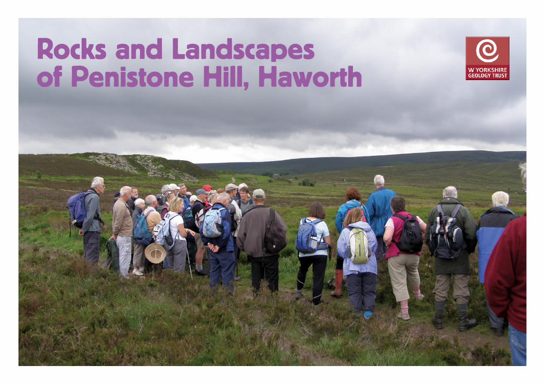
Rocks and Landscapes of Penistone Hill, Haworth
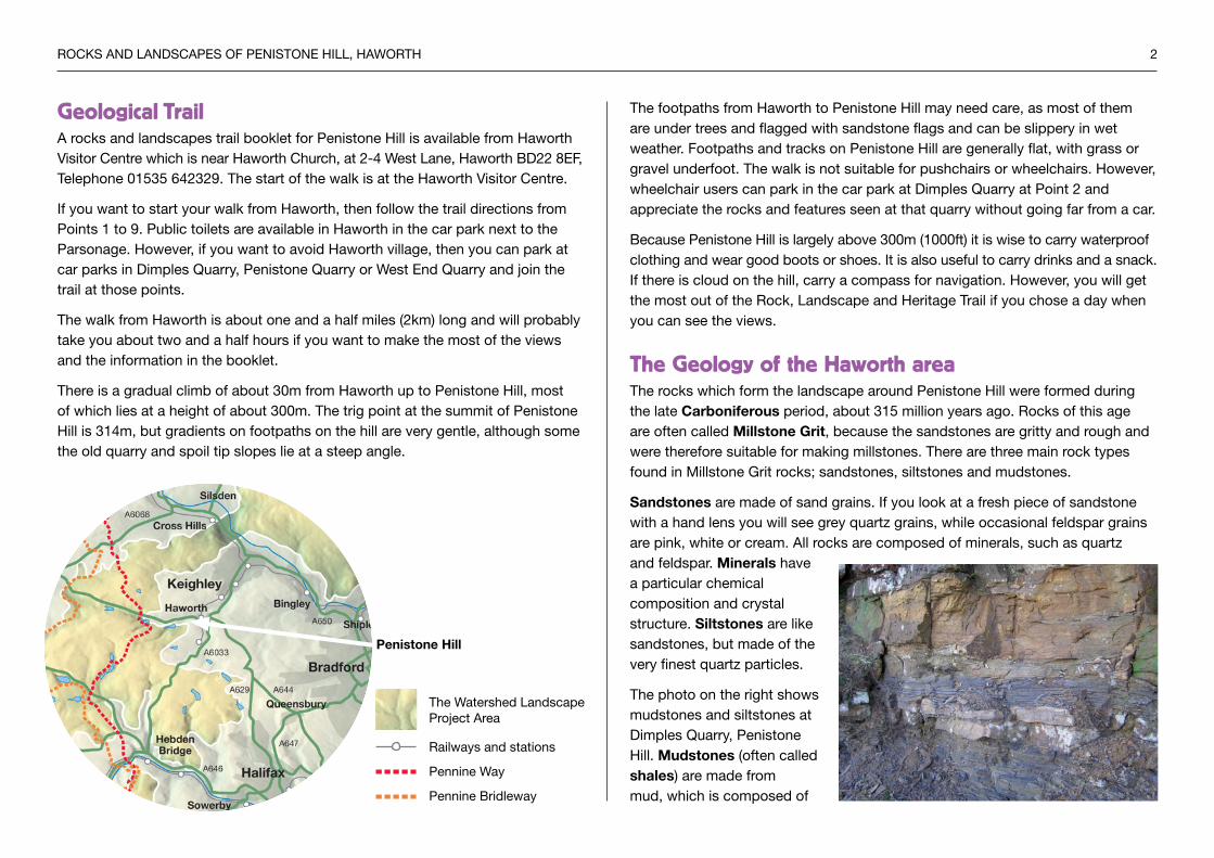
Geological TrailA rocks and landscapes trail booklet for Penistone Hill is available from Haworth Visitor Centre which is near Haworth Church, at 2-4 West Lane, Haworth BD22 8EF, Telephone 01535 642329. The start of the walk is at the Haworth Visitor Centre.
If you want to start your walk from Haworth, then follow the trail directions from Points 1 to 9. Public toilets are available in Haworth in the car park next to the Parsonage. However, if you want to avoid Haworth village, then you can park at car parks in Dimples Quarry, Penistone Quarry or West End Quarry and join the trail at those points.
The walk from Haworth is about one and a half miles (2km) long and will probably take you about two and a half hours if you want to make the most of the views and the information in the booklet.
There is a gradual climb of about 30m from Haworth up to Penistone Hill, most of which lies at a height of about 300m. The trig point at the summit of Penistone Hill is 314m, but gradients on footpaths on the hill are very gentle, although some the old quarry and spoil tip slopes lie at a steep angle.
The Watershed Landscape Project Area
Railways and stations
Pennine Way
Pennine Bridleway
RoCks AnD LAnDsCAPEs oF PEnIsTonE HILL, HAWoRTH 2
The footpaths from Haworth to Penistone Hill may need care, as most of them are under trees and flagged with sandstone flags and can be slippery in wet weather. Footpaths and tracks on Penistone Hill are generally flat, with grass or gravel underfoot. The walk is not suitable for pushchairs or wheelchairs. However, wheelchair users can park in the car park at Dimples Quarry at Point 2 and appreciate the rocks and features seen at that quarry without going far from a car.
Because Penistone Hill is largely above 300m (1000ft) it is wise to carry waterproof clothing and wear good boots or shoes. It is also useful to carry drinks and a snack. If there is cloud on the hill, carry a compass for navigation. However, you will get the most out of the Rock, Landscape and Heritage Trail if you chose a day when you can see the views.
The Geology of the Haworth areaThe rocks which form the landscape around Penistone Hill were formed during the late Carboniferous period, about 315 million years ago. Rocks of this age are often called Millstone Grit, because the sandstones are gritty and rough and were therefore suitable for making millstones. There are three main rock types found in Millstone Grit rocks; sandstones, siltstones and mudstones.
Sandstones are made of sand grains. If you look at a fresh piece of sandstone with a hand lens you will see grey quartz grains, while occasional feldspar grains are pink, white or cream. All rocks are composed of minerals, such as quartz and feldspar. Minerals have a particular chemical composition and crystal structure. Siltstones are like sandstones, but made of the very finest quartz particles.
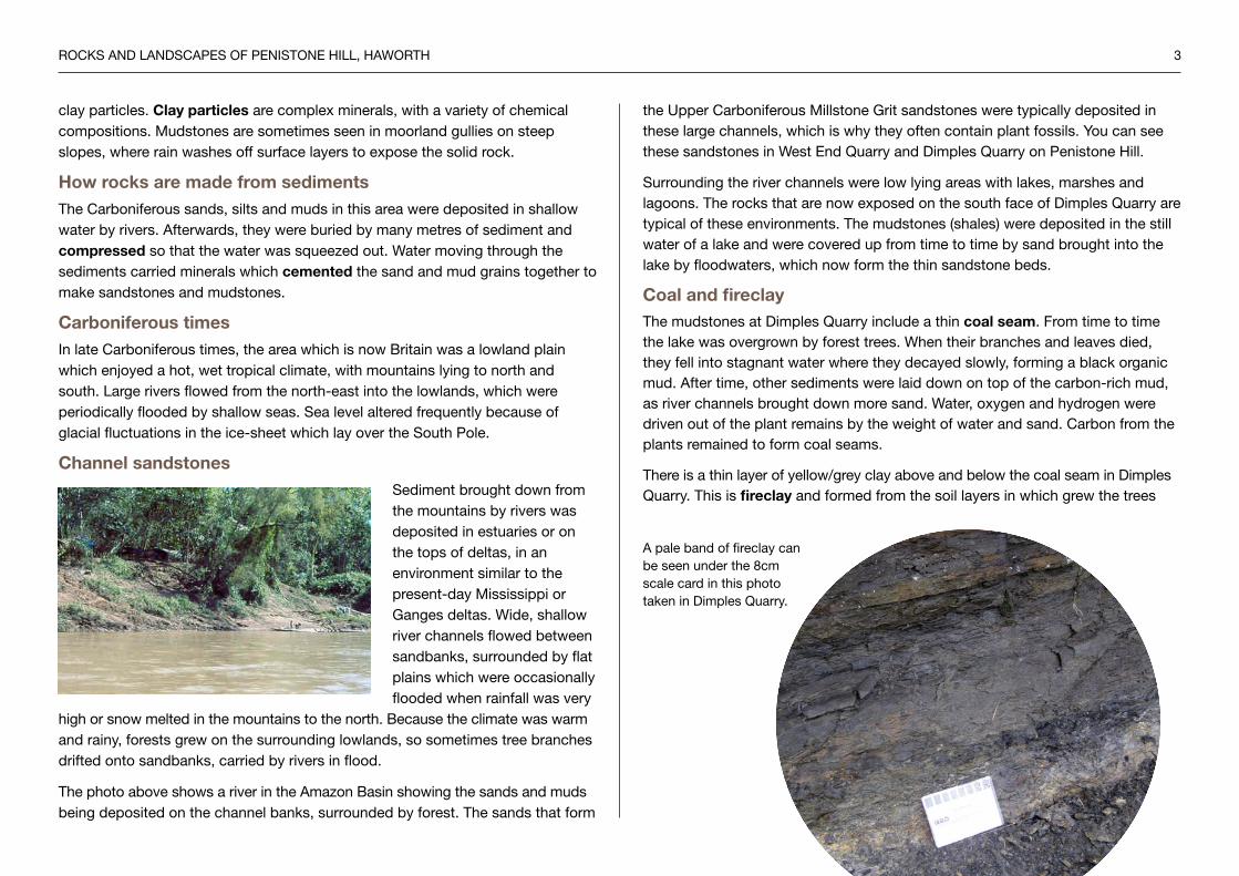
The photo on the right shows mudstones and siltstones at Dimples Quarry, Penistone Hill. Mudstones (often called shales) are made from mud, which is composed of
Penistone Hill
RoCks AnD LAnDsCAPEs oF PEnIsTonE HILL, HAWoRTH 3
clay particles. Clay particles are complex minerals, with a variety of chemical compositions. Mudstones are sometimes seen in moorland gullies on steep slopes, where rain washes off surface layers to expose the solid rock.
How rocks are made from sedimentsThe Carboniferous sands, silts and muds in this area were deposited in shallow water by rivers. Afterwards, they were buried by many metres of sediment and compressed so that the water was squeezed out. Water moving through the sediments carried minerals which cemented the sand and mud grains together to make sandstones and mudstones.
Carboniferous timesIn late Carboniferous times, the area which is now Britain was a lowland plain which enjoyed a hot, wet tropical climate, with mountains lying to north and south. Large rivers flowed from the north-east into the lowlands, which were periodically flooded by shallow seas. sea level altered frequently because of glacial fluctuations in the ice-sheet which lay over the south Pole.
Channel sandstonessediment brought down from the mountains by rivers was deposited in estuaries or on the tops of deltas, in an environment similar to the present-day Mississippi or Ganges deltas. Wide, shallow river channels flowed between sandbanks, surrounded by flat plains which were occasionally flooded when rainfall was very
high or snow melted in the mountains to the north. Because the climate was warm and rainy, forests grew on the surrounding lowlands, so sometimes tree branches drifted onto sandbanks, carried by rivers in flood.
The photo above shows a river in the Amazon Basin showing the sands and muds being deposited on the channel banks, surrounded by forest. The sands that form
the Upper Carboniferous Millstone Grit sandstones were typically deposited in these large channels, which is why they often contain plant fossils. You can see these sandstones in West End Quarry and Dimples Quarry on Penistone Hill.
surrounding the river channels were low lying areas with lakes, marshes and lagoons. The rocks that are now exposed on the south face of Dimples Quarry are typical of these environments. The mudstones (shales) were deposited in the still water of a lake and were covered up from time to time by sand brought into the lake by floodwaters, which now form the thin sandstone beds.
Coal and fireclayThe mudstones at Dimples Quarry include a thin coal seam. From time to time the lake was overgrown by forest trees. When their branches and leaves died, they fell into stagnant water where they decayed slowly, forming a black organic mud. After time, other sediments were laid down on top of the carbon-rich mud, as river channels brought down more sand. Water, oxygen and hydrogen were driven out of the plant remains by the weight of water and sand. Carbon from the plants remained to form coal seams.
There is a thin layer of yellow/grey clay above and below the coal seam in Dimples Quarry. This is fireclay and formed from the soil layers in which grew the trees
A pale band of fireclay can be seen under the 8cm scale card in this photo taken in Dimples Quarry.

RoCks AnD LAnDsCAPEs oF PEnIsTonE HILL, HAWoRTH 4
and ground vegetation that formed the coal. In other parts of West Yorkshire there are thick layers of fireclay below coal seams and these have been exploited to make refractory bricks for furnaces.
Dimples Quarry SE 0256 3701
In front of the car park at Dimples Quarry is a gently dipping section of
sandstones, siltstones and mudstones in a 5m high disused quarry face shown
in the photo. These rocks would not have been very valuable for the quarrymen,
so would have been removed to expose the good quality sandstone below. The
waste rock was tipped into spoil tips around the quarry, most of which have been
landscaped since.
The rocks quarried here are called the High Moor sandstone and the Doubler
stones sandstone. When it was working, the quarry was at least 25-30 metres
deep with the best stone being found in the deepest sections, beneath stone
of poorer quality. The quarry was infilled in 1973 and landscaped during the
following few years.
Carefully walk up the ramp from the car park to inspect the mudstones and
siltstones more closely. You may be able to see a very dark layer which has
shiny faces. This is a small coal seam and shows that the mudstones formed
in a swamp into which trees, branches and leaves would have fallen and been
buried by mud. Therefore the plants could not decompose and the carbon was
preserved as a thin layer of coal.
There is a carving of a Carboniferous tree trunk, carved by stevan Tica of
Baildon, on one side of the quarry, next to a rock face. The carving shows a
Lepidodendron which is from a family of plants called lycopsids. note the leaf
scales on the tree trunk and the small rootlet indentations on the roots. on the
other side of the trunk is carved a large dragonfly which would have lived in the
Carboniferous forests.
To the right of the car park there is a low sandstone cliff behind some trees. Have
a close look at the sandstone, preferably with a hand-lens. This stone is good
quality and is typical of the rocks that were exploited in Dimples Quarry. You
should be able to find some fossils of plant branches on the rocks. stevan Tica’s carving of a Lepidodendron.
Countryside volunteers find out about sedimentary rocks in Dimples Quarry.

RoCks AnD LAnDsCAPEs oF PEnIsTonE HILL, HAWoRTH 5
Viewpoint over the Worth Valley from SE 0245 3713The whole length of the Worth Valley can be seen, from its source near the flat topped Wycoller Ark on the left, to keighley on the right.
This valley once had many textile mills which were powered by the stream. The only visible sign of these mills now is the chimney of Providence Mill which stands alone on the opposite side of the valley.
From this viewpoint you can see across the Worth Valley to Hare Hill Edge on the horizon above the hamlet of oldfield. Above a whitewashed farm (Milking Hill), there is an area of quarried ground now overgrown with heather. This is Blue stone Delph (delph is an old word meaning a quarry or diggings), where an unusual blue/grey sandstone called the keighley Blue stone was quarried.
The Keighley Blue Stone is a very thin sandstone and does not outcrop on
The photo shows the view down the Upper Worth valley towards Haworth and keighley.
Penistone Hill. However, it has been extensively quarried on Hare Hill Edge
as roadstone, as it is very resistant to wear from heavy vehicles, being better
cemented than the other local sandstones.
Coal mine site on Penistone Slack SE 0202 3653
There is a disused coal shaft in the heathery ground just in front of a stone
carving. The carving shows the headstock above the mine shaft, connected to
a horse-powered gin which lowered men and equipment into the mine and lifted
tubs of coal out.
The mine shaft’s position is shown on the photo. The shaft has been capped with
concrete and nothing can be seen of it now. Census records show that there were
miners living in Haworth in 1841, but not in 1851, so probably the mining here
ended during the 1840s, although the mine was reopened briefly in the 1870s.
Coal mine site showing the postion of the mine shaft.

RoCks AnD LAnDsCAPEs oF PEnIsTonE HILL, HAWoRTH 6
Cross-bedding in the Woodhouse Flags at West End Quarry. West End Quarry was in operation from the 1840s to the 1960s.
West End Quarry SE 0207 3641From the car park near West End Quarry, you can walk down to see the quarry face and the huge tips of waste sandstone. West End Quarry and Penistone Quarry nearby exploited a sandstone called the Woodhouse Flags. It was very good quality for construction purposes. Another carving by stevan Tica, which lies at the foot of the rock face, shows a river channel flowing through layers of sand.
The rocks you can see on the cliff face in front of you are made of sandy sediments deposited in a tropical river delta when the Haworth area was located near the equator on a large continent. Layers of sediments were laid upon one another and then compressed over a long period to create solid rock.
The lines on the rock face run in two directions. The horizontal lines are called bedding planes and show that there were times when the river flow slackened
and sand deposition temporarily ceased. Between some of the bedding planes are other lines which slope at a gentle angle and these represent sand banks in the river channel. This feature is called cross-bedding.
Cross-bedding is commonly formed in a river channel in which sand grains are being rolled along the bottom by fast flowing water. The grains avalanche down the front face of sand banks and settle at an angle of about 15º-20º. Each cross-bedded set has been eroded by another flood of water, washing away the top of each sand bank and truncating the cross-bedding.
After the river sands were turned into a rock by being deeply buried, compressed and cemented, earth movements fractured the brittle rock and caused the vertical cracks, called joints. The rusty red colour comes from iron which has been washed through the rock later.
West End Quarry.
Cross-bedding
Joint
Bedding plane
RoCks AnD LAnDsCAPEs oF PEnIsTonE HILL, HAWoRTH 7
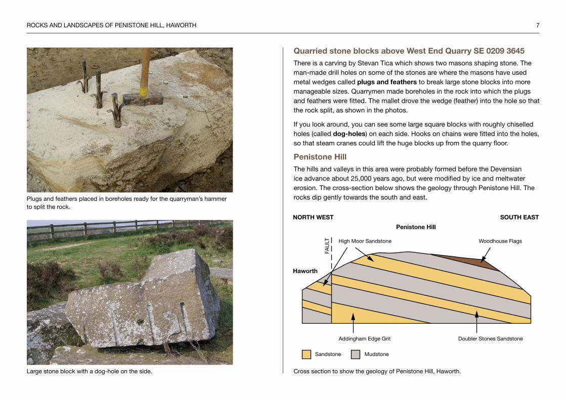
Quarried stone blocks above West End Quarry SE 0209 3645There is a carving by stevan Tica which shows two masons shaping stone. The man-made drill holes on some of the stones are where the masons have used metal wedges called plugs and feathers to break large stone blocks into more manageable sizes. Quarrymen made boreholes in the rock into which the plugs and feathers were fitted. The mallet drove the wedge (feather) into the hole so that the rock split, as shown in the photos.
If you look around, you can see some large square blocks with roughly chiselled holes (called dog-holes) on each side. Hooks on chains were fitted into the holes, so that steam cranes could lift the huge blocks up from the quarry floor.
Penistone HillThe hills and valleys in this area were probably formed before the Devensian ice advance about 25,000 years ago, but were modified by ice and meltwater erosion. The cross-section below shows the geology through Penistone Hill. The rocks dip gently towards the south and east.Plugs and feathers placed in boreholes ready for the quarryman’s hammer
to split the rock.
Large stone block with a dog-hole on the side.
Sandstone Mudstone
Woodhouse FlagsHigh Moor Sandstone
FAU
LT
Doubler Stones SandstoneAddingham Edge Grit
NORTH WEST SOUTH EAST
Penistone Hill
Haworth
Cross section to show the geology of Penistone Hill, Haworth.

RoCks AnD LAnDsCAPEs oF PEnIsTonE HILL, HAWoRTH 8
Building stones in HaworthThe church and other old buildings in Haworth show how local sandstones have been used for building. They contain beds of rock which are strong, well-cemented and load-bearing and can be cut in all directions without weaknesses. Longer pieces of stone have been used for door and window lintels and mullions in cottages, as well as in larger buildings.
It is noticeable that the church does not have elaborate carving, as the local sandstones usually have large sand grains, which do not carve well. However, many quarries also contained beds with fine grained sandstones which could be carved. The gravestones in the churchyard show fine lettering and carving which has lasted well for several hundred years.
some local tracks and lanes are made of rough setts of sandstone, probably to cope with cart wheels, while pedestrians could use the raised flagged path to one side of the track.

RoCks AnD LAnDsCAPEs oF PEnIsTonE HILL, HAWoRTH 9
Acknowledgementssteven Wood for providing the historical information
Colin Waters of the British Geological survey for geological information
Photos © Alison Tymon and Hugh Quarterman
ReferencesTymon, A M, and Wood, s, 2012, Rocks and Landscapes of Penistone Hill, Haworth, West Yorkshire Geology Trust
Waters, C n, Aitkenhead, n, Jones, n s, and Chisholm, J I, 1996, Late Carboniferous stratigraphy and sedimentology of the Bradford area and its implications for the regional geology of Northern England, Proceedings of the Yorkshire Geological society, Vol 51, Pt 2, pp 87-101
stephens, J V, Mitchell, G H, and Edwards, W, 1953, Geology of the country between Bradford and Skipton, Geological survey Memoir
http://www.haworth-village.org.uk/history/places/geology/geology.asp
http://www.wyorksgeologytrust.org/
Useful mapsos sHEET 1:50,000 Landranger 104 Leeds and Bradford
os sHEET: 1:25,000 Explorer oL21 south Pennines
British Geological survey 1:50,000 Geological sheet 69 Bradford
Written by Alison Tymon © West Yorkshire Geology Trust 2013
www.wyorksgeologytrust.org
West Yorkshire Geology Trust (WYGT) is part of a national network of groups which are actively conserving important geological features. These sites include rocky crags, active or disused quarries, railway cuttings and stream beds. Important sites are called Local Geological sites (LGs) and there are about 80 in the county. West Yorkshire Geology Trust aims to encourage public enjoyment of rocks, fossils and landscapes and link geological features with the local industrial heritage. WYGT also maintains a database of Local Geological sites and encourages landowners and managers to participate in good site practice and management.
This leaflet has been produced with support from the Watershed Landscape Project, a three year Heritage Lottery Funded project managed by Pennine Prospects to enhance and conserve the south Pennine upland landscape and its heritage, whilst improving access for all.
The aims of the project are to protect the internationally important natural and historic features of this special landscape and to encourage greater understanding and enjoyment of the area so that it is further valued and protected. The project has been telling the fascinating stories of the moors by offering opportunities to get involved in local heritage projects, delivering moorland conservation initiatives, developing resources to help people explore the landscape, hosting exciting events and activities, and working with artists and writers on an original creative arts programme.
For more information about the Watershed Landscape Project please visit www.watershedlandscape.co.uk