Embed Size (px)
Citation preview
Route Weather Resilience and Climate Change Adaptation Plans
South East

South East Route: WRCCA plan
Network Rail 1
Contents
Director Route Asset Management statement 2
Executive Summary 3
Introduction 4
South East Route WRCCA strategy 7
South East Route vulnerability assessment 8
South East Route impact assessment 15
South East Route WRCCA actions 23
Management and review 25
Purpose of this document
This document sets out a Weather Resilience and Climate Change Adaptation (WRCCA) plan
for South East Route supported by an evaluation of the resilience of rail infrastructure to
historical weather events and an awareness of potential impacts from regional climate change
projections. The resilience of rolling stock operating within the Route is not specifically
assessed.
The approach taken is consistent across all Network Rail’s Routes, and describes our current
planned mitigations, how we intend to develop the plans further, and how we are improving the
embedment of WRCCA across the business to deliver a railway fit for the future.
South East Route: WRCCA plan
Network Rail 2
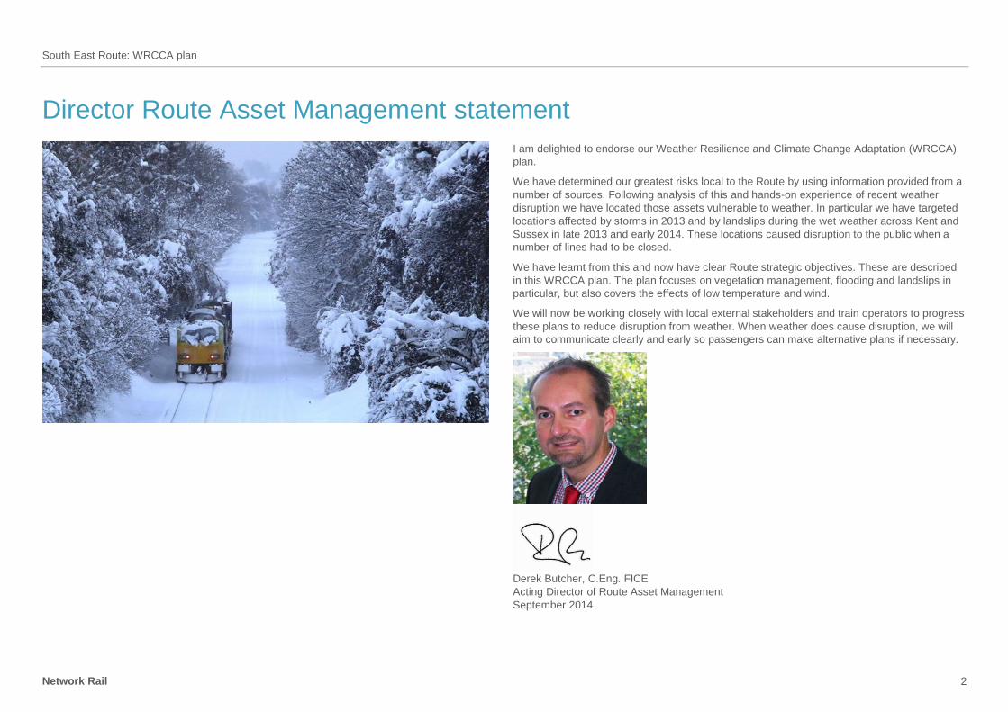
Director Route Asset Management statement
I am delighted to endorse our Weather Resilience and Climate Change Adaptation (WRCCA)
plan.
We have determined our greatest risks local to the Route by using information provided from a
number of sources. Following analysis of this and hands-on experience of recent weather
disruption we have located those assets vulnerable to weather. In particular we have targeted
locations affected by storms in 2013 and by landslips during the wet weather across Kent and
Sussex in late 2013 and early 2014. These locations caused disruption to the public when a
number of lines had to be closed.
We have learnt from this and now have clear Route strategic objectives. These are described
in this WRCCA plan. The plan focuses on vegetation management, flooding and landslips in
particular, but also covers the effects of low temperature and wind.
We will now be working closely with local external stakeholders and train operators to progress
these plans to reduce disruption from weather. When weather does cause disruption, we will
aim to communicate clearly and early so passengers can make alternative plans if necessary.
Derek Butcher, C.Eng. FICE
Acting Director of Route Asset Management
September 2014
South East Route: WRCCA plan
Network Rail 3
Executive Summary
Weather events can cause significant disruption to the operation of train services and damage
to rail infrastructure. A move to a warmer climate and a variance in the pattern of precipitation
across the year, generally projected by the UK Climate Change Projections (UKCP09), could
result in changes in the frequency and intensity of extreme weather events and seasonal
patterns. A detailed understanding of the vulnerability of rail assets to weather events, and
potential impacts from climate change, are therefore needed to maintain a resilient railway.
South East Route, established in 2014 following the merging of Sussex and Kent Routes, has
developed a Weather Resilience and Climate Change Adaptation (WRCCA) plan based on
assessments of weather-related vulnerabilities, identification of root causes of historical
performance impacts and an understanding of potential future impacts from regional climate
change projections. Using this information, South East Route has determined whether previous
investments have mitigated weather impact risks, if actions planned during Control Period 5
(CP5) (2014 to 2019) are addressing these vulnerabilities, and where additional actions could
further enhance weather and climate change resilience.
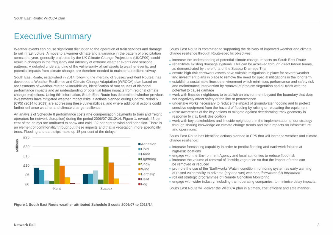
An analysis of Schedule 8 performance costs (the compensation payments to train and freight
operators for network disruption) during the period 2006/07-2013/14, Figure 1, reveals 48 per
cent of the delays are attributed to snow and cold, 32 per cent to wind and adhesion. There is
an element of commonality throughout these impacts and that is vegetation, more specifically,
trees. Flooding and earthslips make up 15 per cent of the delays.
£0
£5
£10
£15
£20
£25
Kent Sussex
Millio
ns
Adhesion
Cold
Flood
Lightning
Snow
Wind
Earthslip
Heat
Fog
Figure 1 South East Route weather attributed Schedule 8 costs 2006/07 to 2013/14
South East Route is committed to supporting the delivery of improved weather and climate
change resilience through Route-specific objectives:
increase the understanding of potential climate change impacts on South East Route
rehabilitate existing drainage systems. This can be achieved through direct labour teams,
as demonstrated by the efforts of the Sussex Drainage Trial
ensure high-risk earthwork assets have suitable mitigations in place for severe weather
and investment plans in place to remove the need for special mitigations in the long term
establish a sustainable lineside environment which minimises performance and safety risk
and maintenance intervention by removal of problem vegetation and all trees with the
potential to cause damage
work with lineside neighbours to establish an environment beyond the boundary that does
not negatively affect safety of the line or performance
undertake works necessary to reduce the impact of groundwater flooding and to protect
sensitive equipment from the hazard of flooding by raising or relocating the equipment
raise awareness of the key actions to mitigate against deteriorating track geometry in
response to clay bank desiccation
work with key stakeholders and lineside neighbours in the implementation of our strategy
through sharing knowledge on climate change trends and their impacts on infrastructure
and operations.
South East Route has identified actions planned in CP5 that will increase weather and climate
change resilience:
increase forecasting capability in order to predict flooding and earthwork failures at
high-risk locations
engage with the Environment Agency and local authorities to reduce flood risk
increase the volume of removal of lineside vegetation so that the impact of trees can
be removed or reduced
promote the use of the ‘Earthworks Watch’ condition monitoring system as early warning
of raised vulnerability to adverse (dry and wet) weather, ‘forewarned is forearmed’
roll out strategic programmes of Remote Condition Monitoring
engage with wider industry, including train operating companies, to minimise delay impacts.
South East Route will deliver the WRCCA plan in a timely, cost efficient and safe manner.
South East Route: WRCCA plan
Network Rail 4
Introduction
Weather events can be a cause of significant disruption to the railway network. Recent
prolonged periods of rainfall and extreme storm events demonstrated much of the network
is resilient. However, asset failures in the South East Route, established in 2014 following the
merging of Sussex and Kent Routes, such as earthslips at Ockley and Stonegate, and the
widespread tree fall during the St. Jude storm in December 2013, reveal the vulnerability of
the rail network and the severe impact these weaknesses in resilience have on train services
and our resources.
The impact of weather on the rail network is monitored using performance data. Schedule 8
costs; the compensation payments to train and freight operators for network disruption, are
used as a proxy for weather impacts due to greater granularity of root cause reporting.
Weather-related costs can also be captured within Schedule 4 payments; compensation to
train and freight operators for Network Rail’s possession of the network, and capital
expenditure required to reinstate the asset.
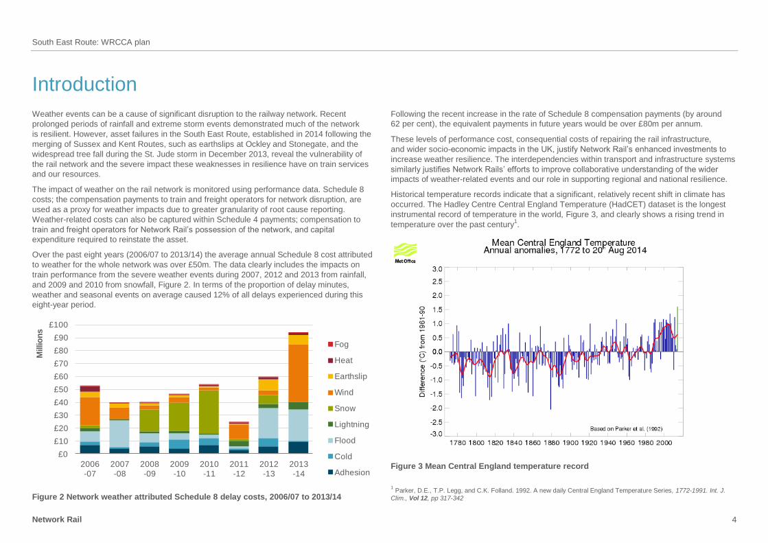
Over the past eight years (2006/07 to 2013/14) the average annual Schedule 8 cost attributed
to weather for the whole network was over £50m. The data clearly includes the impacts on
train performance from the severe weather events during 2007, 2012 and 2013 from rainfall,
and 2009 and 2010 from snowfall, Figure 2. In terms of the proportion of delay minutes,
weather and seasonal events on average caused 12% of all delays experienced during this
eight-year period.
£0
£10
£20
£30
£40
£50
£60
£70
£80
£90
£100
2006-07
2007-08
2008-09
2009-10
2010-11
2011-12
2012-13
2013-14
Millio
ns
Fog
Heat
Earthslip
Wind
Snow
Lightning
Flood
Cold
Adhesion
Figure 2 Network weather attributed Schedule 8 delay costs, 2006/07 to 2013/14
Following the recent increase in the rate of Schedule 8 compensation payments (by around
62 per cent), the equivalent payments in future years would be over £80m per annum.
These levels of performance cost, consequential costs of repairing the rail infrastructure,
and wider socio-economic impacts in the UK, justify Network Rail’s enhanced investments to
increase weather resilience. The interdependencies within transport and infrastructure systems
similarly justifies Network Rails’ efforts to improve collaborative understanding of the wider
impacts of weather-related events and our role in supporting regional and national resilience.
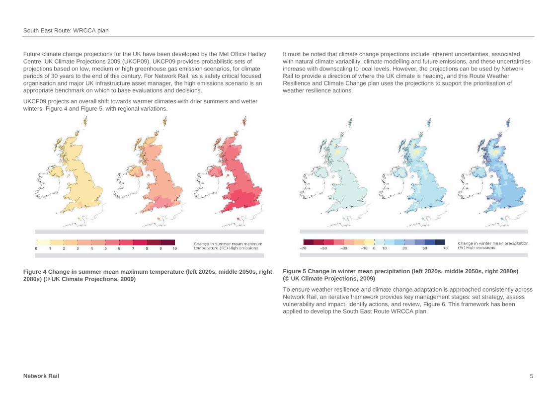
Historical temperature records indicate that a significant, relatively recent shift in climate has
occurred. The Hadley Centre Central England Temperature (HadCET) dataset is the longest
instrumental record of temperature in the world, Figure 3, and clearly shows a rising trend in
temperature over the past century1.
Figure 3 Mean Central England temperature record
1 Parker, D.E., T.P. Legg, and C.K. Folland. 1992. A new daily Central England Temperature Series, 1772-1991. Int. J.
Clim., Vol 12, pp 317-342
South East Route: WRCCA plan
Network Rail 5
Future climate change projections for the UK have been developed by the Met Office Hadley
Centre, UK Climate Projections 2009 (UKCP09). UKCP09 provides probabilistic sets of
projections based on low, medium or high greenhouse gas emission scenarios, for climate
periods of 30 years to the end of this century. For Network Rail, as a safety critical focused
organisation and major UK infrastructure asset manager, the high emissions scenario is an
appropriate benchmark on which to base evaluations and decisions.
UKCP09 projects an overall shift towards warmer climates with drier summers and wetter
winters, Figure 4 and Figure 5, with regional variations.
Figure 4 Change in summer mean maximum temperature (left 2020s, middle 2050s, right
2080s) (© UK Climate Projections, 2009)
It must be noted that climate change projections include inherent uncertainties, associated
with natural climate variability, climate modelling and future emissions, and these uncertainties
increase with downscaling to local levels. However, the projections can be used by Network
Rail to provide a direction of where the UK climate is heading, and this Route Weather
Resilience and Climate Change plan uses the projections to support the prioritisation of
weather resilience actions.
Figure 5 Change in winter mean precipitation (left 2020s, middle 2050s, right 2080s)
(© UK Climate Projections, 2009)
To ensure weather resilience and climate change adaptation is approached consistently across
Network Rail, an iterative framework provides key management stages: set strategy, assess
vulnerability and impact, identify actions, and review, Figure 6. This framework has been
applied to develop the South East Route WRCCA plan.
South East Route: WRCCA plan
Network Rail 6
Strategy
and policy
Vulnerability
assessment
Adaptation
actions
Impact
assessment
Management
and review
Figure 6 Weather resilience and climate change adaptation framework
Network Rail weather resilience and climate change adaptation actions will include a range
of measures appropriate to the strength of evidence and level of risk:
soft – changes to processes, standards and specifications, increasing knowledge and
skill base
hard – engineered solutions to increase resilience e.g. raising of sea walls, repairs to weak
earthworks and increasing drainage capacity
‘do nothing/minimum’ – the option to ‘do nothing’ or ‘do minimum’ should be evaluated
‘no regrets’ – measures that increase the resilience of the assets to current and
future impacts
precautionary – investment into adaptation measures today in anticipation of risk in the future
managed adaptive – a staged approach incorporating uncertainties in future risk and current
investment funds, allowing assets to be retro-fitted cost-effectively in the future.
The following sections provide findings from the South East Route vulnerability and impact
assessments, and details of the WRCCA actions; both completed and planned in CP5, and
potential additional actions, that aim to increase weather and climate change resilience.
Figure 7 River Arun occupies the full flood plain traversed by the TBH at Amberley,
February 2014
South East Route: WRCCA plan
Network Rail 7
South East Route WRCCA strategy
The Network Rail Sustainable Development Strategy outlines corporate weather resilience
and climate change adaptation objectives, and commits the business to:
understand our current weather resilience, and seek to optimise resilience and enhance
adaptation capability
develop a thorough understanding of the potential impacts of climate change in terms
of infrastructure performance, safety risks and costs
embed climate change adaptation within our asset policies and investment decisions
communicate the role that the rail network plays in supporting weather and climate
resilience across Great Britain, and support efforts to increase national resilience.
These objectives will support the long-term management of a weather resilient railway and
are fundamental steps towards achieving Network Rail’s sustainable development vision
of a railway fit for the future.
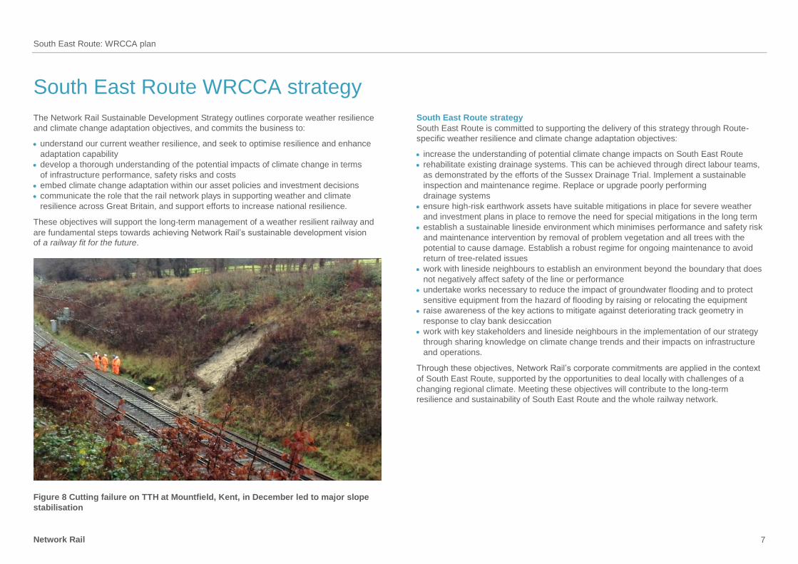
Figure 8 Cutting failure on TTH at Mountfield, Kent, in December led to major slope
stabilisation
South East Route strategy
South East Route is committed to supporting the delivery of this strategy through Route-
specific weather resilience and climate change adaptation objectives:
increase the understanding of potential climate change impacts on South East Route
rehabilitate existing drainage systems. This can be achieved through direct labour teams,
as demonstrated by the efforts of the Sussex Drainage Trial. Implement a sustainable
inspection and maintenance regime. Replace or upgrade poorly performing
drainage systems
ensure high-risk earthwork assets have suitable mitigations in place for severe weather
and investment plans in place to remove the need for special mitigations in the long term
establish a sustainable lineside environment which minimises performance and safety risk
and maintenance intervention by removal of problem vegetation and all trees with the
potential to cause damage. Establish a robust regime for ongoing maintenance to avoid
return of tree-related issues
work with lineside neighbours to establish an environment beyond the boundary that does
not negatively affect safety of the line or performance
undertake works necessary to reduce the impact of groundwater flooding and to protect
sensitive equipment from the hazard of flooding by raising or relocating the equipment
raise awareness of the key actions to mitigate against deteriorating track geometry in
response to clay bank desiccation
work with key stakeholders and lineside neighbours in the implementation of our strategy
through sharing knowledge on climate change trends and their impacts on infrastructure
and operations.
Through these objectives, Network Rail’s corporate commitments are applied in the context
of South East Route, supported by the opportunities to deal locally with challenges of a
changing regional climate. Meeting these objectives will contribute to the long-term
resilience and sustainability of South East Route and the whole railway network.
South East Route: WRCCA plan
Network Rail 8
South East Route vulnerability assessment
This section provides the details of the general vulnerability of the rail network in Great Britain
and South East Route’s specific vulnerabilities to weather impacts, and regional climate
change projections.
Network-wide weather vulnerability
The challenge for Network Rail is to manage a complex and extensive portfolio of assets, with
variations in geographic location, age, deterioration rates and vulnerability to weather impacts.
Continual analysis of the vulnerability of rail assets to weather, and identification of trends and
characteristics of weather-triggered failures, improves our knowledge of the resilience of the
rail network. An understanding of current weather impacts is an essential platform to implement
cost-effective investments to adapt the network to future changes in climate.
The whole rail network is sensitive and exposed in some way to many primary climate drivers
and secondary impacts, including:
temperature
rainfall
wind gusts
flooding
landslips
soil moisture
sea level rise
coastal erosion.
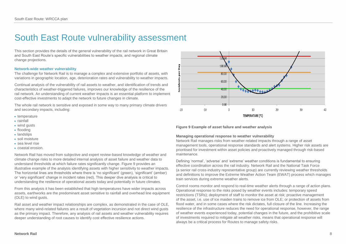
Network Rail has moved from subjective and expert review-based knowledge of weather and
climate change risks to more detailed internal analysis of asset failure and weather data to
understand thresholds at which failure rates significantly change. Figure 9 provides an
illustrative example of the analysis identifying assets with higher sensitivity to weather impacts.
The horizontal lines are thresholds where there is ‘no significant’ (green), ‘significant’ (amber)
or ‘very significant’ change in incident rates (red). This deeper dive analysis is critical to
understanding the resilience of operational assets today and potentially in future climates.
From this analysis it has been established that high temperatures have wider impacts across
assets, earthworks are the predominant asset sensitive to rainfall and overhead line equipment
(OLE) to wind gusts.
Rail asset and weather impact relationships are complex, as demonstrated in the case of OLE,
where many wind-related failures are a result of vegetation incursion and not direct wind gusts
as the primary impact. Therefore, any analysis of rail assets and weather vulnerability requires
deeper understanding of root causes to identify cost effective resilience actions.
Figure 9 Example of asset failure and weather analysis
Managing operational response to weather vulnerability
Network Rail manages risks from weather-related impacts through a range of asset
management tools, operational response standards and alert systems. Higher risk assets are
prioritised for investment within asset policies and proactively managed through risk-based
maintenance.
Defining ‘normal’, ‘adverse’ and ‘extreme’ weather conditions is fundamental to ensuring
effective coordination across the rail industry. Network Rail and the National Task Force
(a senior rail cross-industry representative group) are currently reviewing weather thresholds
and definitions to improve the Extreme Weather Action Team (EWAT) process which manages
train services during extreme weather alerts.
Control rooms monitor and respond to real-time weather alerts through a range of action plans.
Operational response to the risks posed by weather events includes: temporary speed
restrictions (TSRs); deployment of staff to monitor the asset at risk; proactive management
of the asset, i.e. use of ice maiden trains to remove ice from OLE; or protection of assets from
flood water, and in some cases where the risk dictates, full closure of the line. Increasing the
resilience of the infrastructure reduces the need for operational response, however, the range
of weather events experienced today, potential changes in the future, and the prohibitive scale
of investments required to mitigate all weather risks, means that operational response will
always be a critical process for Routes to manage safety risks.
South East Route: WRCCA plan
Network Rail 9
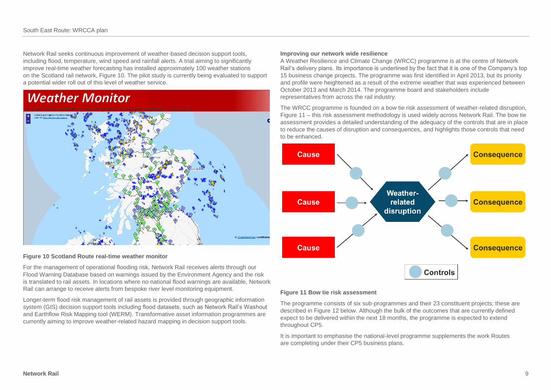
Network Rail seeks continuous improvement of weather-based decision support tools,
including flood, temperature, wind speed and rainfall alerts. A trial aiming to significantly
improve real-time weather forecasting has installed approximately 100 weather stations
on the Scotland rail network, Figure 10. The pilot study is currently being evaluated to support
a potential wider roll out of this level of weather service.
Figure 10 Scotland Route real-time weather monitor
For the management of operational flooding risk, Network Rail receives alerts through our
Flood Warning Database based on warnings issued by the Environment Agency and the risk
is translated to rail assets. In locations where no national flood warnings are available, Network
Rail can arrange to receive alerts from bespoke river level monitoring equipment.
Longer-term flood risk management of rail assets is provided through geographic information
system (GIS) decision support tools including flood datasets, such as Network Rail’s Washout
and Earthflow Risk Mapping tool (WERM). Transformative asset information programmes are
currently aiming to improve weather-related hazard mapping in decision support tools.
Improving our network wide resilience
A Weather Resilience and Climate Change (WRCC) programme is at the centre of Network
Rail’s delivery plans. Its importance is underlined by the fact that it is one of the Company’s top
15 business change projects. The programme was first identified in April 2013, but its priority
and profile were heightened as a result of the extreme weather that was experienced between
October 2013 and March 2014. The programme board and stakeholders include
representatives from across the rail industry.
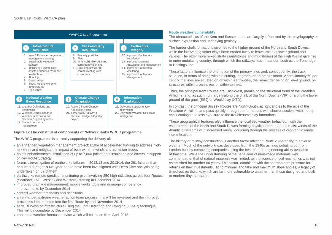
The WRCC programme is founded on a bow tie risk assessment of weather-related disruption,
Figure 11 – this risk assessment methodology is used widely across Network Rail. The bow tie
assessment provides a detailed understanding of the adequacy of the controls that are in place
to reduce the causes of disruption and consequences, and highlights those controls that need
to be enhanced.
Figure 11 Bow tie risk assessment
The programme consists of six sub-programmes and their 23 constituent projects; these are
described in Figure 12 below. Although the bulk of the outcomes that are currently defined
expect to be delivered within the next 18 months, the programme is expected to extend
throughout CP5.
It is important to emphasise the national-level programme supplements the work Routes
are completing under their CP5 business plans.
South East Route: WRCCA plan
Network Rail 10
WWRCC Sub-Programmes
Infrastructure
Resilience
Cross-industry
Resilience
Earthworks
Integrity
National Weather
Event Response
Climate Change
Adaptation
Information
Exploitation
1 2 3
4 5 6
1. Year 1 Enhanced vegetation management strategy
2. Sustainable vegetation strategy
3. Identifying Highest Risk assets Enhanced resilience to effects of:
4. Flooding5. Costal surge6. Snow, Ice and extreme
temperatures7. High winds
8. Property portfolio9. Fleet10. Timetabling-flexibility and
contingency planning11. Providing advice and
communicating with customers
12. Improved Earthworks Knowledge
13. Improved Drainage Knowledge and Management
14. Improved Earthworks Monitoring
15. Improved Earthworks Management
16. Weather Definitions and Thresholds
17. Weather Event Response 18. Weather Information and
Decision Support systems19. Strategic resource
management
20. Route Climate Change Adaptation Plans
21. Tomorrow’s Railway & Climate Change Adaptation project
22. Delivering supplementary information
23. Delivering Weather Resilience Intelligence
Figure 12 The constituent components of Network Rail’s WRCC programme
The WRCC programme is currently supporting the delivery of:
an enhanced vegetation management project: £10m of accelerated funding to address high-
risk trees and mitigate the impact of both extreme winds and adhesion issues
points enhancements: installation of up to 7,000 points heat insulation and covers in support
of Key Route Strategy
forensic investigation of earthworks failures in 2012/13 and 2013/14: the 261 failures that
occurred during this two-year period have been investigated with Deep Dive analysis being
undertaken on 89 of them
earthworks remote condition monitoring pilot: involving 250 high-risk sites across four Routes
(Scotland, LNE, Wessex and Western) starting in December 2014
improved drainage management: mobile works tools and drainage competency
improvements by December 2014
agreed weather thresholds and definitions
an enhanced extreme weather action team process: this will be reviewed and the improved
processes implemented into the first Route by end November 2014
aerial surveys of infrastructure using the Light Detecting and Ranging (LIDAR) technique;
This will be complete by December 2014
enhanced weather forecast service which will be in use from April 2015.
Route weather vulnerability
The characteristics of the Kent and Sussex areas are largely influenced by the physiography or
surface expression and underlying geology.
The harder chalk formations give rise to the higher ground of the North and South Downs,
while the intervening softer clays have eroded away to leave tracts of lower ground and
valleys. The older more mixed strata (sandstones and mudstones) of the High Weald give rise
to more undulating country, through which the railways must meander, such as the Tonbridge
to Hastings line.
These factors influence the orientation of the primary lines and, consequently, the track
situation, in terms of being within a cutting, ‘at grade’ or on embankment. Approximately 60 per
cent of the lines are situated on or within earthworks, the remainder being on level ground, on
structures within urban areas or within tunnels.
Thus, the principal Kent Routes are East-West, parallel to the structural trend of the Wealden
Anticline, and, as such, run largely along the chalk of the North Downs (VIR) or along the lower
ground of the gault (SBJ) or Weald clay (XTD).
In contrast, the principal Sussex Routes are North-South, at right angles to the axis of the
Wealden Anticline, and pass quickly through the formations with shorter sections within deep
chalk cuttings and less exposure to the troublesome clay formations.
These geographical features also influence the localised weather behaviour, with the
escarpments of the North and South Downs forming physical barriers to the moist winds of the
Atlantic airstreams with increased rainfall occurring through the process of orographic rainfall
intensification.
The history of railway construction is another factor affecting Route vulnerability to adverse
weather. Much of the network was developed from the 1840s as lines radiating out from
London built by competing companies using the best of their engineering ability available
at that time. While the understanding of the behaviour of man-made materials was
commendable, that of natural materials was limited, as the science of soil mechanics was not
established for another 60 years. This factor, combined with the shareholders pressure for
returns on their investments, led to minimal land take and maximum slope angles, a legacy of
timed-out earthworks which are far more vulnerable to weather than those designed and built
to modern day standards.
South East Route: WRCCA plan
Network Rail 11
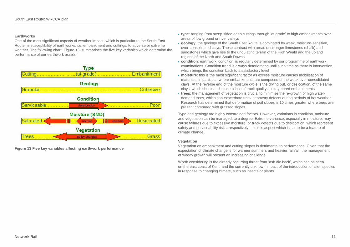
Earthworks
One of the most significant aspects of weather impact, which is particular to the South East
Route, is susceptibility of earthworks, i.e. embankment and cuttings, to adverse or extreme
weather. The following chart, Figure 13, summarises the five key variables which determine the
performance of our earthwork assets:
Figure 13 Five key variables affecting earthwork performance
type: ranging from steep-sided deep cuttings through ‘at grade’ to high embankments over
areas of low ground or river valleys
geology: the geology of the South East Route is dominated by weak, moisture-sensitive,
over-consolidated clays. These contrast with areas of stronger limestones (chalk) and
sandstones which give rise to the undulating terrain of the High Weald and the upland
regions of the North and South Downs
condition: earthwork ‘condition’ is regularly determined by our programme of earthwork
examinations. Condition trend is always deteriorating until such time as there is intervention,
which brings the condition back to a satisfactory level
moisture: this is the most significant factor as excess moisture causes mobilisation of
materials, in particular where embankments are composed of the weak over-consolidated
clays. At the reverse end of the moisture cycle is the drying out, or desiccation, of the same
clays, which shrink and cause a loss of track quality on clay-cored embankments
trees: the management of vegetation is crucial to minimise the re-growth of high water-
demand trees, which can exacerbate track geometry defects during periods of hot weather.
Research has determined that deformation of soil slopes is 10 times greater where trees are
present compared with grassed slopes.
Type and geology are highly constrained factors. However, variations in condition, moisture
and vegetation can be managed, to a degree. Extreme variance, especially in moisture, may
cause failures due to excessive moisture, or track defects due to desiccation, which represent
safety and serviceability risks, respectively. It is this aspect which is set to be a feature of
climate change.
Vegetation
Vegetation on embankment and cutting slopes is detrimental to performance. Given that the
expectation of climate change is for warmer summers and heavier rainfall, the management
of woody growth will present an increasing challenge.
Worth considering is the already occurring threat from ‘ash die back’, which can be seen
on the east coast of Kent, and the currently unknown impact of the introduction of alien species
in response to changing climate, such as insects or plants.
South East Route: WRCCA plan
Network Rail 12
Flooding
The geological fabric also controls the propensity for flooding. The softer clay bedrocks give
rise to tracts of low-lying, poorly drained landscape where fluvial flooding occurs through the
limited ability of the natural watercourses to cope with heavy rainfall. Gatwick is situated within
such an area.
River and estuarine flooding occurs in main river valleys where outfall is impeded by natural
or man-made constrictions, such as in the Arun Valley south of Pulborough.
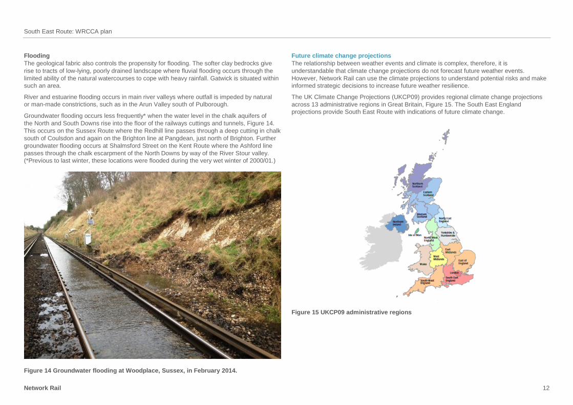
Groundwater flooding occurs less frequently* when the water level in the chalk aquifers of
the North and South Downs rise into the floor of the railways cuttings and tunnels, Figure 14.
This occurs on the Sussex Route where the Redhill line passes through a deep cutting in chalk
south of Coulsdon and again on the Brighton line at Pangdean, just north of Brighton. Further
groundwater flooding occurs at Shalmsford Street on the Kent Route where the Ashford line
passes through the chalk escarpment of the North Downs by way of the River Stour valley.
(*Previous to last winter, these locations were flooded during the very wet winter of 2000/01.)
Figure 14 Groundwater flooding at Woodplace, Sussex, in February 2014.
Future climate change projections
The relationship between weather events and climate is complex, therefore, it is
understandable that climate change projections do not forecast future weather events.
However, Network Rail can use the climate projections to understand potential risks and make
informed strategic decisions to increase future weather resilience.
The UK Climate Change Projections (UKCP09) provides regional climate change projections
across 13 administrative regions in Great Britain, Figure 15. The South East England
projections provide South East Route with indications of future climate change.
Figure 15 UKCP09 administrative regions
South East Route: WRCCA plan
Network Rail 13
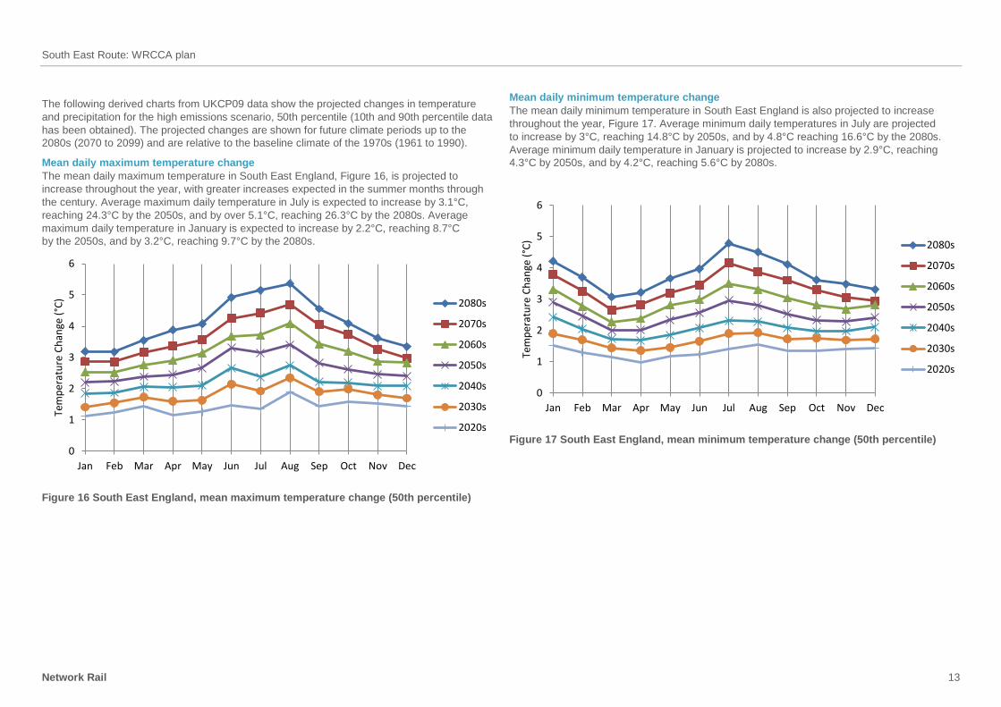
The following derived charts from UKCP09 data show the projected changes in temperature
and precipitation for the high emissions scenario, 50th percentile (10th and 90th percentile data
has been obtained). The projected changes are shown for future climate periods up to the
2080s (2070 to 2099) and are relative to the baseline climate of the 1970s (1961 to 1990).
Mean daily maximum temperature change
The mean daily maximum temperature in South East England, Figure 16, is projected to
increase throughout the year, with greater increases expected in the summer months through
the century. Average maximum daily temperature in July is expected to increase by 3.1°C,
reaching 24.3°C by the 2050s, and by over 5.1°C, reaching 26.3°C by the 2080s. Average
maximum daily temperature in January is expected to increase by 2.2°C, reaching 8.7°C
by the 2050s, and by 3.2°C, reaching 9.7°C by the 2080s.
0
1
2
3
4
5
6
Jan Feb Mar Apr May Jun Jul Aug Sep Oct Nov Dec
Tem
per
atu
re C
han
ge (
°C) 2080s
2070s
2060s
2050s
2040s
2030s
2020s
Figure 16 South East England, mean maximum temperature change (50th percentile)
Mean daily minimum temperature change
The mean daily minimum temperature in South East England is also projected to increase
throughout the year, Figure 17. Average minimum daily temperatures in July are projected
to increase by 3°C, reaching 14.8°C by 2050s, and by 4.8°C reaching 16.6°C by the 2080s.
Average minimum daily temperature in January is projected to increase by 2.9°C, reaching
4.3°C by 2050s, and by 4.2°C, reaching 5.6°C by 2080s.
0
1
2
3
4
5
6
Jan Feb Mar Apr May Jun Jul Aug Sep Oct Nov Dec
Tem
per
atu
re C
han
ge (
°C) 2080s
2070s
2060s
2050s
2040s
2030s
2020s
Figure 17 South East England, mean minimum temperature change (50th percentile)
South East Route: WRCCA plan
Network Rail 14
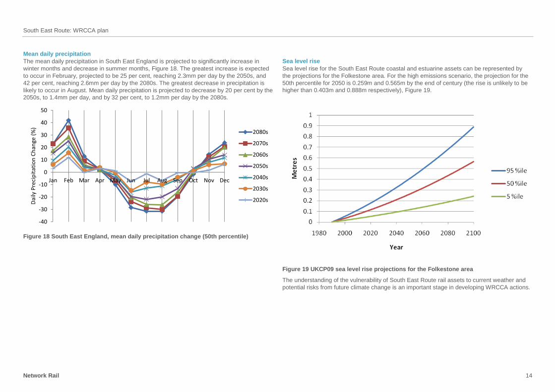
Mean daily precipitation
The mean daily precipitation in South East England is projected to significantly increase in
winter months and decrease in summer months, Figure 18. The greatest increase is expected
to occur in February, projected to be 25 per cent, reaching 2.3mm per day by the 2050s, and
42 per cent, reaching 2.6mm per day by the 2080s. The greatest decrease in precipitation is
likely to occur in August. Mean daily precipitation is projected to decrease by 20 per cent by the
2050s, to 1.4mm per day, and by 32 per cent, to 1.2mm per day by the 2080s.
-40
-30
-20
-10
0
10
20
30
40
50
Jan Feb Mar Apr May Jun Jul Aug Sep Oct Nov Dec
Dai
ly P
reci
pit
atio
n C
han
ge (
%)
2080s
2070s
2060s
2050s
2040s
2030s
2020s
Figure 18 South East England, mean daily precipitation change (50th percentile)
Sea level rise
Sea level rise for the South East Route coastal and estuarine assets can be represented by
the projections for the Folkestone area. For the high emissions scenario, the projection for the
50th percentile for 2050 is 0.259m and 0.565m by the end of century (the rise is unlikely to be
higher than 0.403m and 0.888m respectively), Figure 19.
Figure 19 UKCP09 sea level rise projections for the Folkestone area
The understanding of the vulnerability of South East Route rail assets to current weather and
potential risks from future climate change is an important stage in developing WRCCA actions.
South East Route: WRCCA plan
Network Rail 15
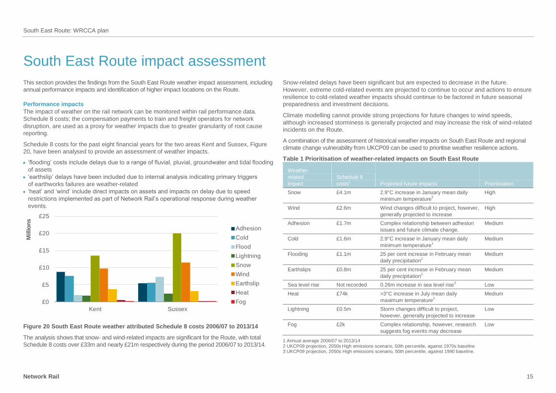
South East Route impact assessment
This section provides the findings from the South East Route weather impact assessment, including
annual performance impacts and identification of higher impact locations on the Route.
Performance impacts
The impact of weather on the rail network can be monitored within rail performance data.
Schedule 8 costs; the compensation payments to train and freight operators for network
disruption, are used as a proxy for weather impacts due to greater granularity of root cause
reporting.
Schedule 8 costs for the past eight financial years for the two areas Kent and Sussex, Figure
20, have been analysed to provide an assessment of weather impacts.
‘flooding’ costs include delays due to a range of fluvial, pluvial, groundwater and tidal flooding
of assets
‘earthslip’ delays have been included due to internal analysis indicating primary triggers
of earthworks failures are weather-related
‘heat’ and ‘wind’ include direct impacts on assets and impacts on delay due to speed
restrictions implemented as part of Network Rail’s operational response during weather
events.
£0
£5
£10
£15
£20
£25
Kent Sussex
Millio
ns
Adhesion
Cold
Flood
Lightning
Snow
Wind
Earthslip
Heat
Fog
Figure 20 South East Route weather attributed Schedule 8 costs 2006/07 to 2013/14
The analysis shows that snow- and wind-related impacts are significant for the Route, with total
Schedule 8 costs over £33m and nearly £21m respectively during the period 2006/07 to 2013/14.
Snow-related delays have been significant but are expected to decrease in the future.
However, extreme cold-related events are projected to continue to occur and actions to ensure
resilience to cold-related weather impacts should continue to be factored in future seasonal
preparedness and investment decisions.
Climate modelling cannot provide strong projections for future changes to wind speeds,
although increased storminess is generally projected and may increase the risk of wind-related
incidents on the Route.
A combination of the assessment of historical weather impacts on South East Route and regional
climate change vulnerability from UKCP09 can be used to prioritise weather resilience actions.
Table 1 Prioritisation of weather-related impacts on South East Route
Weather-
related
impact
Schedule 8
costs1 Projected future impacts Prioritisation
Snow £4.1m 2.9°C increase in January mean daily
minimum temperature2
High
Wind £2.6m Wind changes difficult to project, however,
generally projected to increase
High
Adhesion £1.7m Complex relationship between adhesion
issues and future climate change.
Medium
Cold £1.6m 2.9°C increase in January mean daily
minimum temperature1
Medium
Flooding £1.1m 25 per cent increase in February mean
daily precipitation2
Medium
Earthslips £0.8m 25 per cent increase in February mean
daily precipitation2
Medium
Sea level rise Not recorded 0.26m increase in sea level rise3 Low
Heat £74k >3°C increase in July mean daily
maximum temperature2
Medium
Lightning £0.5m Storm changes difficult to project,
however, generally projected to increase
Low
Fog £2k Complex relationship, however, research
suggests fog events may decrease
Low
1 Annual average 2006/07 to 2013/14
2 UKCP09 projection, 2050s High emissions scenario, 50th percentile, against 1970s baseline
3 UKCP09 projection, 2050s High emissions scenario, 50th percentile, against 1990 baseline.
South East Route: WRCCA plan
Network Rail 16
The above data shows clearly the prevalence of snow, cold, wind and adhesion as the primary
causes of lost minutes, totalling 80 per cent of all delays across the South East Route.
It is also worth noting the Schedule 8 cost per delay minute in CP5 will be on average
60 per cent higher, further reinforcing the importance of effective WRCCA actions.
Identification of higher risk locations
A geographic information system (GIS) based decision support tool, METEX, has been
developed to analyse gridded observed weather data and rail data, including the past eight
years of delays attributed to weather.
Over recent years, our network has experienced some of the most extreme weather on record
and weaknesses in existing assets will be captured in performance impacts. Climate change is
projected to impact the UK with more intense and frequent extreme weather events, so taking
actions on our current weaknesses, and proactively managing future risks are important steps
to increasing our future resilience.
Higher-risk locations have been identified by assessing METEX outputs for high-frequency/
high-cost sites across the whole Route, and detailed assessment of key sections of the rail
network. These locations have been assessed to determine:
validity of the delay attribution to a weather impact
root cause of the delay
resilience actions that have been undertaken
resilience actions that are currently planned
identification and prioritisation of additional resilience actions.
In addition, Routes have identified potential future risks and resilience actions based on climate
change projections and Route knowledge.
Snow and cold impact assessment
Based on the 2006/07 to 2013/14 data, the combined impact of cold and snow was £67m,
representing 48 per cent of the total Schedule 8 costs for Kent and Sussex combined. In recent
years, Ashford and Brighton have incurred the most delays for this impact on the Route,
amounting to almost £10m. Measures taken to mitigate the effects of snow and cold at these
locations include installing more conductor rail heating, no splitting of trains in cold conditions
and staff on the ground to react to incidents. While this is not sufficient to completely mitigate
the risk, there has been an improvement in delays in the last few years, as the figures show.
While the climate change projections would suggest an improving situation for frequency of
cold days, the fact is, that even the shortest periods of cold and/or snow have a debilitating
impact on the network. We have increased the amount of conductor rail heating in both Kent
and Sussex, we run anti-ice MPVs and we have a Key Route Strategy (KRS) to mitigate the
risk, which involves the use of Snow Ice Treatment Trains (SITTs). However, cold weather had
little operational impact last winter, and if the weather continues this way, it may become of
reduced concern in the longer term.
Most assets are impacted by the effects of snow and cold, and measures are taken to reduce
these impacts on all fronts. A concern for structures and buildings is the risk of shrinkage and
fracture of metal components, leaks from accumulating snow on and around buildings, slippery
conditions around buildings and on walkways, and snow and wind blowing platform copers out
of alignment. Ice formation in tunnels also poses a risk to the running of trains, as sheets of ice
can form icicles in front of the path of the train and cause damage, or break off without
warning; this is also a potential hazard. To mitigate this, tunnel checks are carried out by track
patrollers, who have equipment to remove ice sheets if found.
While conductor rail heating holds many benefits which can be seen through the positive
effects of its installation, there is the drawback that it increases the power consumption
required by the line. For example, con-rail heating on the partly fitted out Tonbridge to Hastings
line already draws 1MW from the system. This means there is an increasing draw on the power
supply during cold weather, as it is required not only to run the trains and power them, but also
for points heaters and conductor rail heating, and this is a risk within itself.
Cold weather poses perhaps the biggest risk to track; ice formation on the third rail prevents
trains from accessing the power supply via the shoe gear and often results in arcing and
sparking which damages the train and the track, points can become frozen which prevents
paths from being set by signallers, and a build-up of snow on the track simply means that trains
cannot run until cleared by the SITT, much as roads need to be cleared by a snowplough
before cars can drive through them.
While conductor rail heating and points heating go some way towards mitigating the effects of
ice, a large amount of snow does render these ineffective, and often further costs are incurred
in repairing the equipment. There was also an incident where disruption of services was
exacerbated in the Kent snow of December 2010 because trains could not pass the trees,
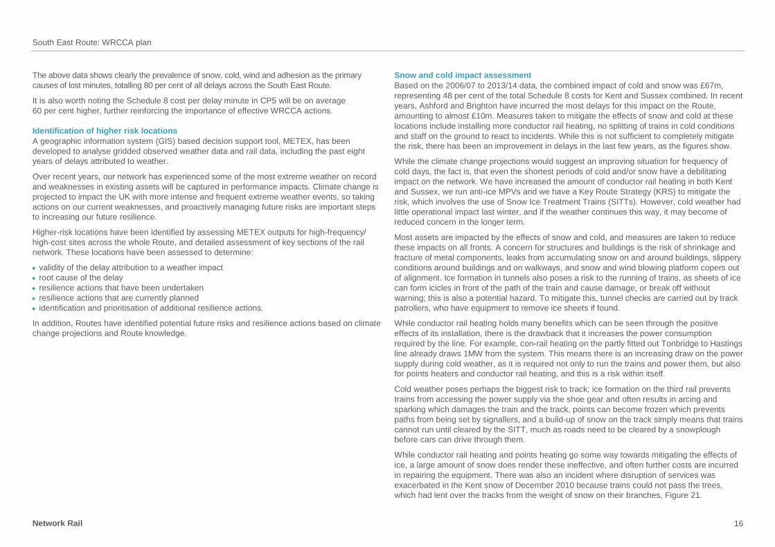
which had lent over the tracks from the weight of snow on their branches, Figure 21.
South East Route: WRCCA plan
Network Rail 17
Figure 21 Wet snow in April 2006 brought the trees down over the tracks on TTH
at Tunbridge Wells
Apart from snow melt, snow and cold has limited impact on earthwork stability. The more
significant impact is from the freeze – thaw process which damages rock and, in particular
chalk, cuttings. The lines through the Hooley cuttings were closed for several days in 1947
when a long period of freezing weather ended with a rapid thaw, which caused the vegetal
debris and weathered chalk to slough off the cutting faces and block the lines.
The following mitigation will reduce the impact from snow and cold:
better forecasting of snow conditions so that emergency timetables can be instigated
in good time
removal of lineside trees to prevent line blockage
expand the programme for con-rail heating and points heating
ensure adequate de-icing arrangements and material supplies in conjunction with train
operating companies etc.
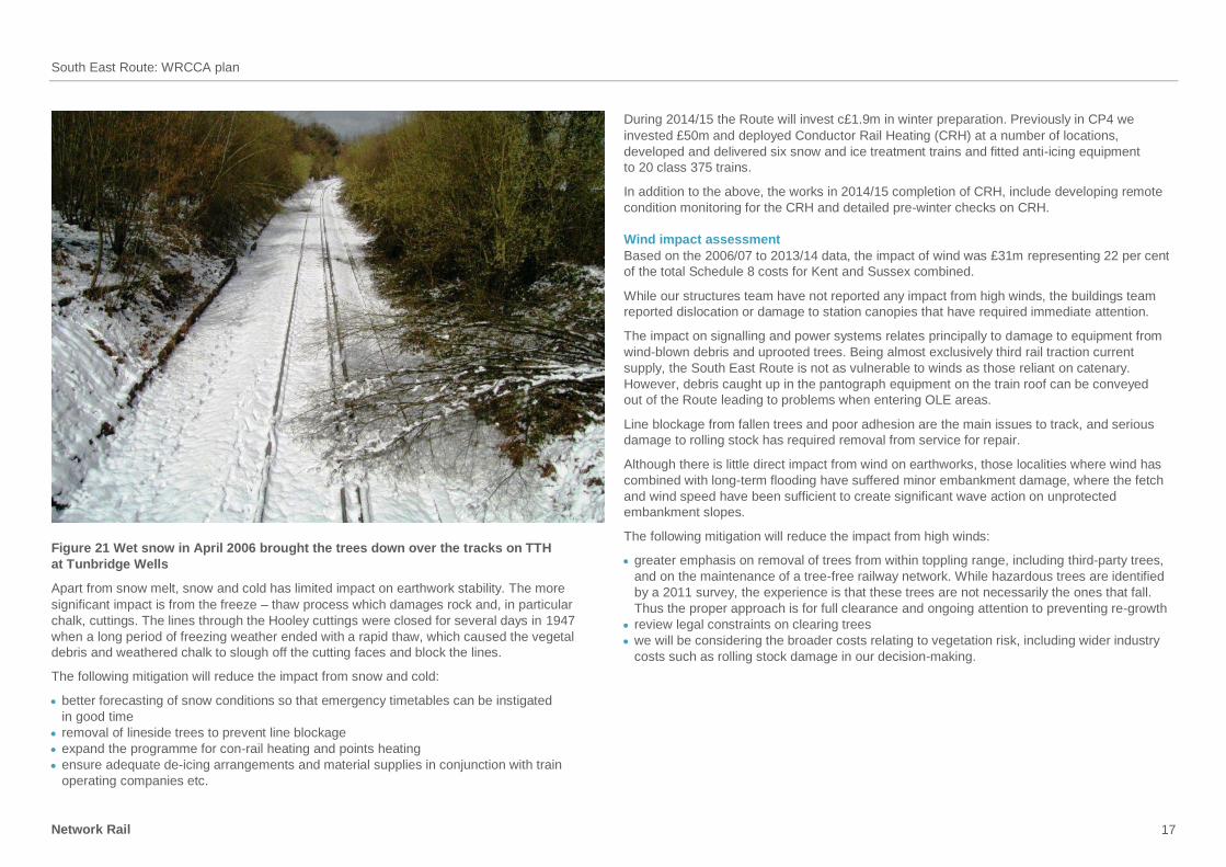
During 2014/15 the Route will invest c£1.9m in winter preparation. Previously in CP4 we
invested £50m and deployed Conductor Rail Heating (CRH) at a number of locations,
developed and delivered six snow and ice treatment trains and fitted anti-icing equipment
to 20 class 375 trains.
In addition to the above, the works in 2014/15 completion of CRH, include developing remote
condition monitoring for the CRH and detailed pre-winter checks on CRH.
Wind impact assessment
Based on the 2006/07 to 2013/14 data, the impact of wind was £31m representing 22 per cent
of the total Schedule 8 costs for Kent and Sussex combined.
While our structures team have not reported any impact from high winds, the buildings team
reported dislocation or damage to station canopies that have required immediate attention.
The impact on signalling and power systems relates principally to damage to equipment from
wind-blown debris and uprooted trees. Being almost exclusively third rail traction current
supply, the South East Route is not as vulnerable to winds as those reliant on catenary.
However, debris caught up in the pantograph equipment on the train roof can be conveyed
out of the Route leading to problems when entering OLE areas.
Line blockage from fallen trees and poor adhesion are the main issues to track, and serious
damage to rolling stock has required removal from service for repair.
Although there is little direct impact from wind on earthworks, those localities where wind has
combined with long-term flooding have suffered minor embankment damage, where the fetch
and wind speed have been sufficient to create significant wave action on unprotected
embankment slopes.
The following mitigation will reduce the impact from high winds:
greater emphasis on removal of trees from within toppling range, including third-party trees,
and on the maintenance of a tree-free railway network. While hazardous trees are identified
by a 2011 survey, the experience is that these trees are not necessarily the ones that fall.
Thus the proper approach is for full clearance and ongoing attention to preventing re-growth
review legal constraints on clearing trees
we will be considering the broader costs relating to vegetation risk, including wider industry
costs such as rolling stock damage in our decision-making.
South East Route: WRCCA plan
Network Rail 18
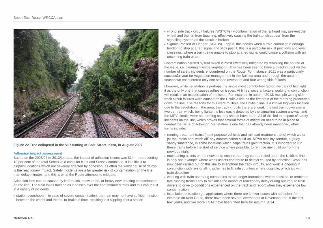
Figure 22 Tree collapsed in the VIR cutting at Sole Street, Kent, in August 2007.
Adhesion impact assessment
Based on the 2006/07 to 2013/14 data, the impact of adhesion issues was £14m, representing
10 per cent of the total Schedule 8 costs for Kent and Sussex combined. It is difficult to
pinpoint locations which are severely affected by adhesion, as often the worst cause of delays
is the reactionary impact. Safety incidents are a far greater risk of contamination on the line
than delay minutes, and this is what the Route attempts to mitigate.
Adhesion loss can be caused by leaf mulch, snow or ice, or heavy dew creating contamination
on the line. The train loses traction as it passes over the contaminated track and this can result
in a variety of incidents:
station overshoots – in case of severe contamination, the train may not have sufficient friction
between the wheel and the rail to brake in time, resulting in it slipping past a station
wrong side track circuit failures (WSTCFs) – contamination of the railhead may prevent the
wheel and the rail from touching, effectively causing the train to ‘disappear’ from the
signalling system as the circuit is broken
Signals Passed At Danger (SPADs) – again, this occurs when a train cannot gain enough
traction to stop at a red signal and slips past it; this is a particular risk at junctions and level
crossings, where a train being unable to stop at a red signal could cause a collision with an
oncoming train or car.
Contamination caused by leaf mulch is most effectively mitigated by removing the source of
the issue, i.e. clearing lineside vegetation. This has been seen to have a direct impact on the
number of safety incidents encountered on the Route. For instance, 2011 was a particularly
successful year for vegetation management in the Sussex area and through the autumn
season we encountered only one station overshoot and four wrong side failures.
However, while vegetation is perhaps the single most contributory factor, we cannot highlight
it as the only one that causes adhesion issues. At times, several factors working in conjunction
will result in an exacerbation of the issue. For instance, in autumn 2013, multiple wrong side
track circuit failures were caused on the Uckfield line as the first train of the morning proceeded
down the line. The reasons for this were multiple: the Uckfield line is a known high-risk location
due to the vegetation in the area; the track circuits there are weak; the first train down was a
two car train which, being lighter, is less easily detected by the signalling system anyway; and
the MPV circuits were not running as they should have been. All of this led to a spate of safety
incidents on the line, which proves that several forms of mitigation need to be in place to
combat the issue of adhesion. Vegetation is one that has already been mentioned, other
forms include:
running treatment trains (multi-purpose vehicles and railhead treatment trains) which water
jet the tracks and ‘wash off’ any contamination build up. MPVs also lay sandite, a gluey
sandy substance, in some locations which helps trains gain traction. It is important to run
these trains before the start of service where possible, to remove any build up from the
previous night
maintaining assets on the network to ensure that they can be relied upon; the Uckfield line
is only one example where weak assets contribute to delays caused by adhesion. Work has
now been carried out on this line to strengthen the track circuits, and work is ongoing in
conjunction with re-signalling schemes to fit axle counters where possible, which aid with
train detection
working with train operating companies to run longer formations where possible, to terminate
late running trains early to minimise the impact of reactionary delay during autumn, to train
drivers to drive to conditions experienced on the track and report when they experience low
contamination
installation of traction gel applicators where there are known issues with adhesion; for
example on Kent Route, there have been several overshoots at Ravensbourne in the last
few years, and two more TGAs have been fitted here for autumn 2014.
South East Route: WRCCA plan
Network Rail 19
Vegetation clearance has been carried out at approximately 90 per cent of high-risk sites
identified from the autumn 2013 review on the South East Route, but the most important part
of vegetation clearance is maintenance: once clear, maintain clear. Therefore, a
comprehensive strategy is being pulled together for CP5 to ensure that once sites are cleared,
they do not become an issue again.
Previously, the South East Route only used multi-purpose vehicles (MPVs) to treat the tracks
but this year, six rail head treatment trains (RHTTs) are being brought down to the Route for
use in autumn 2014. Not only does this greatly enhance the resources available to us, but it is
also believed that RHTTs are more effective than MPVs in clearing contamination off the track
due to the higher pressure water jetting sprays and their larger water capacity, meaning they
can run for longer. We therefore expect to see adhesion having a greatly reduced impact on
the Route this year. Train operating companies also make minor changes to their timetables
during autumn to allow for treatment trains to run on the network, and also to reduce the impact
of reactionary delays.
New weather systems are also going to be used to forecast low adhesion, taking into account
factors such as vegetation, microclimates, and dew or the ‘wet rail syndrome’. These will help
to understand where our resources and efforts to mitigate adhesion should be focused.
Flooding and earthslip impact assessment
Based on the 2006/07 to 2013/14, the combined impact of flooding and earthslips was £21m
representing 15 per cent of the total Schedule 8 costs for Kent and Sussex combined.
Most of the earthslip issues in Sussex and Kent have been remediated by the completion of
both planned works and reactive remedial works. Those locations where emergency response
was limited to removal of debris, additional works are being carried out through minor works to
reinstate earthworks back to their pre-failure condition with additional protection and mitigation
measures included, as necessary.
The Route has developed adverse weather plans as a part of the EWAT process for the
management of adverse or extreme weather events. In terms of earthwork stability, the plan
makes use of the ‘Earthworks Watch’ system, which provides forewarning of conditions which
could facilitate earthslips during extreme weather events. This helps with the management of
resources required for checks on sensitive earthworks which have been subjected to intensive
rainfall, so that the safety of the line is not compromised.
Remote condition monitoring has been trialled successfully on one of our most vulnerable
cuttings on the Redhill line at Hooley. The cutting has now been completely overhauled
releasing the monitoring equipment for deployment on the adjacent Brighton line cutting where
a number of failures were experienced over last winter. The success of this monitoring
methodology allows its usage to be confidently applied wherever the same conditions and
processes exist.
Flooding remains an increasing challenge as frequency and severity is projected to increase
with climate change.
Flooding can generally be divided into river (fluvial), surface water (pluvial), tidal and
groundwater. Pluvial flooding is a secondary impact of prolonged heavy rain or cloudbursts
which can overwhelm rail drainage systems. Groundwater is where the geology is porous and
acts as a sponge, or aquifer, which fills up in response to prolonged heavy rainfall, such as the
chalk of the North and South Downs escarpments.
River and surface water flooding is the more common, while groundwater flooding only affects
those locations where the railway has been constructed in the floor of river valleys within chalk
bedrock, such as at Shalmsford Street on the Ashford line or been placed in deep cuttings or
tunnels within chalk bedrock, such as at Pangdean, Woodplace on the Brighton line and
Higham-Strood Tunnel on HDR.
Flooding can cause minor damage to station and lineside buildings through entering the
building and leakage of flat roofs, while the impact on structures can be more severe where
increased scour occurs around bridge abutments. Except for those tunnels passing through
the permeable chalk of the North and South Downs, water ingress and disposal is becoming
an increasing challenge requiring costly seepage interception systems and renewal of six foot
drainage systems where their functionality has become compromised by track lowering
schemes causing repeated track flooding and service interruption.
South East Route: WRCCA plan
Network Rail 20
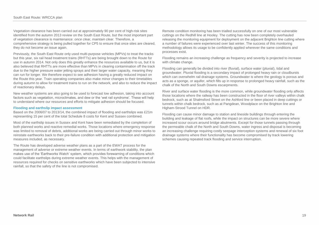
Figure 23 Groundwater flooding closed the ACR line at Shelmsford Street, Kent,
in February 2014.
Both signalling (S&T) and power (E&P) are vulnerable to damage to equipment from surface
or groundwater flooding and measures are being taken to enhance the protection of sensitive
equipment and, where possible, relocate equipment away from locations prone to groundwater
flooding, such as in Pangdean cutting.
The propensity for earthwork failure is raised during periods of wet weather and flooding
through the raising of inter-granular pore water pressure, and mobilisation of material and
through the physical removal of materials, as is the case with scour. A further process
experienced over the last winter was the re-activation of sinkholes, both natural solution
features and man-made chalk mines or ‘dene holes’. The impact was not great, but our
experiences were mirrored across southern Britain, which experienced a four-fold increase
in reported collapses.
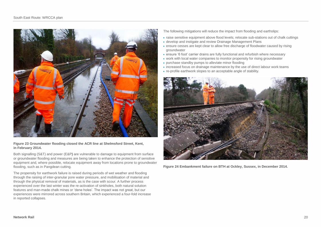
The following mitigations will reduce the impact from flooding and earthslips:
raise sensitive equipment above flood levels; relocate sub-stations out of chalk cuttings
develop and instigate and review Drainage Management Plans
ensure cesses are kept clear to allow free discharge of floodwater caused by rising
groundwater
ensure ‘6 foot’ carrier drains are fully functional and refurbish where necessary
work with local water companies to monitor propensity for rising groundwater
purchase standby pumps to alleviate minor flooding
increased focus on drainage maintenance by the use of direct labour work teams
re-profile earthwork slopes to an acceptable angle of stability.
Figure 24 Embankment failure on BTH at Ockley, Sussex, in December 2014.
South East Route: WRCCA plan
Network Rail 21
Sea level rise impact assessment
The impact of rising sea levels alone is not identified in terms of train delays. However, the
Route has a number of coastal and estuarine sections which could become increasingly
exposed to storm events as sea levels undergo a gradual rise:
Seasalter/Whitstable
Folkestone to Dover
Glynde Gap
Cooden Beach
Arun Valley.
All of these locations benefit from various forms of coastal protection installed at the time of
railway construction. However, in most cases these defences have been incorporated into
ongoing coastal protection schemes carried out and maintained by the Environment Agency.
The main exception to this is the coastal section between Folkestone and Dover where the
railway was built at the foot of the sea cliff or within tunnels just behind the sea cliff. However,
the railway is at an elevation such that it is not affected directly by storm conditions affording
a delay between any damage to the sea defences and any impact on the safety of the line.
A further location at risk from coastal/estuarine flooding is the Newhaven Port, where a recent
storm surge caused seawater inundation with long-term issues over component corrosion.
Storms on the south coast have caused recent overtopping of coastal defences at Bulverhythe,
where shingle was washed on to the tracks causing minor delays to train operations.
There has been little direct impact from sea level rise on earthworks apart from the Folkestone
Warren landslide, which falls within the coastal section between Folkestone and Dover. The
impact here will be from accelerated ground movements caused by a combination of inability
to maintain ground water lowering within the slipped mass and increased ground water
entering the slip surfaces from the Folkestone – Dover chalk block behind.
The following mitigation will reduce the impact from sea level rise:
raising or strengthening of coastal defences
construction of secondary defences where the relevant Shoreline Management Plan (SMP)
has determined a strategy of ‘managed retreat’
maintain liaison with the Environment Agency and relevant coastal groups regarding Coastal,
Estuarine and River Defence (CERD) plans
further coastal defence works to extend the life of the Folkestone Warren protective apron
increased efforts to lower groundwater in the Folkestone Warren landslip complex
the route intends to invest in CP5 in the resilience of the section of coastline between
Folkestone and Dover.
Heat impact assessment
Based on the 2006/07 to 2013/14 data, the impact of heat was £1m representing 1 per cent
of the total Schedule 8 costs for Kent and Sussex combined.
Several, if not all, assets on the railway are affected by heat, and if the trend recently identified
of increasingly hot summers continues, it is something we need to mitigate against. Buildings
and structures are perhaps the least affected; the main concern is overheating of station
buildings, which requires more cooling equipment and increases electricity demand.
Signalling suffers from overheating of equipment cabinets/buildings, and they therefore require
better insulation and more cooling equipment, which also increases electricity demand.
Electronic equipment, such as printed circuit boards, may need to be more robustly
manufactured to maintain functionality at higher temperatures.
From an electrical and power point of view, as mentioned already, increasing temperatures
lead to a reduction in equipment rating and thus available power, with potential for having to
reduce the number of trains drawing on the power. There are also increasing power demands
as old train sets are replaced by those fitted with air conditioning, which draw extra current.
While very limited on the South East Route, OLE equipment may need extra attention to
counter increased loadings from overhead line expansion. The traditional third rail system will
also need extra attention to reduce damage from con-rail buckling or flailing ramp ends, with
associated risk of rolling stock damage.
Rail buckling is one of the main issues for track and requires increased vigilance and resources
to manage it safely through heat speeds and extra tamping. Increased risk of lineside fires will
require increased efforts to minimise litter and clear vegetation. There were several instances
of this in the hot summer experienced this year; several initiatives have now been put in place
to mitigate this in future.
It is estimated that over 65 per cent of embankments in the South East Route are composed
of moisture sensitive clays. (The remainder of the embankments are made of less sensitive
granular rock types with varying susceptibility to shrink-swell or chalk, which is insensitive to
moisture change.) These ‘clay banks’ tend to be constantly shifting as shrink-swell processes
occur in response to seasonal moisture changes. Embankments lose their shape by creeping
away sideways and the losses have been made up in the past by the addition of boiler ash,
which gives rise to the term ‘ash bank’. Now, the tracks are kept up by the addition of ballast.
However, the tracks tend to move apart (become splayed) as the ‘six foot’ widens, such that
safe cess ceases to exist. The rate at which the clay moves is proportional to the seasonal
variations from wetting to drying, and climate change will increase the range causing
acceleration in the demise of clay banks. This desiccation effect, which causes deteriorating
track geometry, is exacerbated in the presence of trees which draw extra water to keep alive,
especially late summer to autumn.
South East Route: WRCCA plan
Network Rail 22
The following mitigation will reduce the impact from high temperatures:
building in of system redundancy where equipment is prone to failure
consideration to raising the Stress Free Temperature (SFT) with research abroad into what
impacts this may have on track maintenance during both hot and cooler weather
correction of settled and splayed banks by bringing tracks back together
optimise opportunities for failure warning through increased Remote Condition Monitoring
(RCM), utilising spare capacity of building monitoring systems
use of the “Earthworks Watch” system for advanced warning of clay bank desiccation such
that proactive tamping can be carried out rather than reactive.
Lightning impact assessment
Based on the 2006/07 to 2013/14 data, the impact of lightning was £6m representing
4 per cent of the total Schedule 8 costs for Kent and Sussex combined.
Lightning protection systems for buildings are generally adequate. However, one must be
mindful of local changes, such as at Ashford depot, where the removal of lightning towers
reduced the protection to the surrounding facilities.
Power systems can be tripped out by lightning surges, but this is currently managed by
adequate supply protection arrangements. The main issue is in the cost of recovery, the capital
cost of restoring Continental Junction after a recent lightning strike was around £0.8m.
The following mitigation will reduce the impact from lightning:
improved earthing arrangements
rapid response to reinstate damaged signalling or power equipment
explore the application Dissipation Array Systems.
Fog impact assessment
Based on the 2006/07 to 2013/14 data, the impact of fog was £0.02m, representing <1 per cent
of the total Schedule 8 costs for Kent and Sussex combined.
Fog is not expected to become an increasing problem with climate change as temperatures are
projected to rise and current controls are considered adequate for now and the future.
South East Route: WRCCA plan
Network Rail 23
South East Route WRCCA actions
Network-wide weather and climate change resilience will be driven predominately by
Network Rail’s Central functions through revision to asset policies and design standards,
technology adoption and root cause analysis. The location specific nature of weather
impacts will require analysis and response at Route level.
This section is a concise summary of South East Route actions planned in CP5, Table 2,
beyond Business as Usual (BAU), and potential additional actions, Table 3, for
consideration in CP5 and future control periods to increase weather and climate change
resilience.
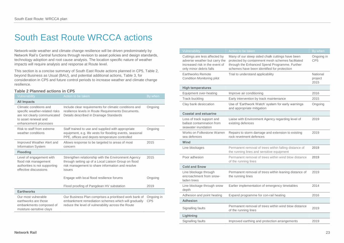
Table 2 Planned actions in CP5
Vulnerability Action to be taken By when
All Impacts
Climatic conditions and
specific weather-related risks
are not clearly communicated
to asset renewal and
enhancement processes
Include clear requirements for climatic conditions and
resilience levels in Route Requirements Documents.
Details described in Drainage Standards
Ongoing
Risk to staff from extreme
weather conditions
Staff trained to use and supplied with appropriate
equipment, e.g. life vests for flooding events, seasonal
PPE, offices and depots temperature controlled
Ongoing
Improved Weather Alert and
Information System
Allows response to be targeted to areas of most
concern
2015
Flooding
Level of engagement with
flood risk management
authorities is not supporting
effective discussions
Strengthen relationship with the Environment Agency
through setting up of a Local Liaison Group on flood
risk management to share information and resolve
issues
Engage with local flood resilience forums
Flood proofing of Pangdean HV substation
2015
Ongoing
2019
Earthworks
Our most vulnerable
earthworks are those
embankments composed of
moisture-sensitive clays
Our Business Plan comprises a prioritised work bank of
embankment remediation schemes which will gradually
reduce the level of vulnerability across the Route
Ongoing in
CP5
Vulnerability Action to be taken By when
Cuttings are less affected by
adverse weather but carry the
increased risk in the event of
only minor debris falls
Many of our steep sided chalk cuttings have been
protected by containment mesh schemes facilitated
through the Enhanced Spend Programme. Further
schemes have been identified for protection
Ongoing in
CP5
Earthworks Remote
Condition Monitoring pilot
Trial to understand applicability National
project
2015
High temperatures
Equipment over-heating Improve air conditioning 2016
Track buckling Early intervention by track maintenance 2015
Clay bank desiccation Use of ‘Earthwork Watch’ system for early warnings
and appropriate mitigation
Ongoing
Coastal and estuarine
Loss of track support and
ballast contamination from
seawater inundation
Liaise with Environment Agency regarding level of
existing defences
2019
Works on Folkestone Warren
sea defences
Repairs to storm damage and extension to existing
rock revetment defences
2019
Wind
Line blockages Permanent removal of trees within falling distance of
the running lines and sensitive equipment
2019
Poor adhesion Permanent removal of trees within wind blow distance
of the running lines
2019
Cold and Snow
Line blockage through
encroachment from snow-
laden trees
Permanent removal of trees within leaning distance of
the running lines
2019
Line blockage through snow
depth
Earlier implementation of emergency timetables 2014
Adhesion and point heating Expand programme for con-rail heating 2016
Adhesion
Signalling faults Permanent removal of trees within wind blow distance
of the running lines 2019
Lightning
Signalling faults Improved earthing and protection arrangements 2019
South East Route: WRCCA plan
Network Rail 24
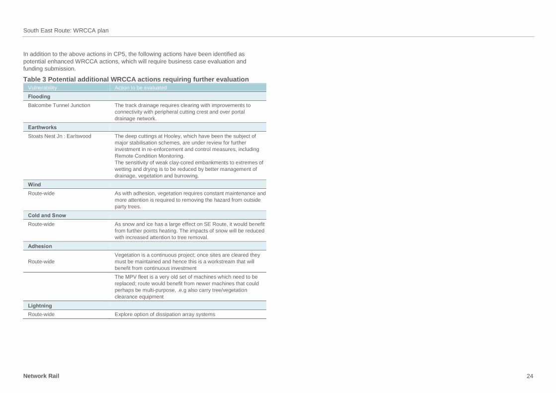
In addition to the above actions in CP5, the following actions have been identified as
potential enhanced WRCCA actions, which will require business case evaluation and
funding submission.
Table 3 Potential additional WRCCA actions requiring further evaluation
Vulnerability Action to be evaluated
Flooding
Balcombe Tunnel Junction The track drainage requires clearing with improvements to
connectivity with peripheral cutting crest and over portal
drainage network.
Earthworks
Stoats Nest Jn : Earlswood The deep cuttings at Hooley, which have been the subject of
major stabilisation schemes, are under review for further
investment in re-enforcement and control measures, including
Remote Condition Monitoring.
The sensitivity of weak clay-cored embankments to extremes of
wetting and drying is to be reduced by better management of
drainage, vegetation and burrowing.
Wind
Route-wide As with adhesion, vegetation requires constant maintenance and
more attention is required to removing the hazard from outside
party trees.
Cold and Snow
Route-wide As snow and ice has a large effect on SE Route, it would benefit
from further points heating. The impacts of snow will be reduced
with increased attention to tree removal.
Adhesion
Route-wide
Vegetation is a continuous project; once sites are cleared they
must be maintained and hence this is a workstream that will
benefit from continuous investment
The MPV fleet is a very old set of machines which need to be
replaced; route would benefit from newer machines that could
perhaps be multi-purpose, .e.g also carry tree/vegetation
clearance equipment
Lightning
Route-wide Explore option of dissipation array systems
South East Route: WRCCA plan
Network Rail 25
Management and review
Corporate management and review
Weather resilience and climate change adaptation will require long-term commitment to
regular review and management across the business. The challenge for the industry, and for
all organisations managing assets vulnerable to weather events, is to develop cost-effective
strategies to accommodate climate change and implement these strategies in a timely
manner to avoid an unacceptable increase in safety risk, reduction in system reliability or
undeliverable downstream risk mitigation strategies.
Key actions being taken within corporate functions include:
Safety, Technical and Engineering – Review of weather and climate change within
asset policies and standards, and monitoring of WRCCA actions through the S&SD
Integrated Plan
Network Operations – Review of the Extreme Weather Action Team process and definition
of ‘normal’, ‘adverse’ and ‘extreme’ weather
Group Strategy – Delivery of future weather resilience in the Long-Term Planning Process
(LTPP)
Infrastructure Projects – Review of weather and climate change within the Governance
for Railway Investment Projects (GRIP).
The progress on WRCCA actions is reported through Network Rail’s governance process to
the Executive Committee as part of regular Strategic Theme business management
updates.
South East Route management and review
The Route management is committed to maintaining engagement with the climate change
reviews and to adjust, where necessary, the resilience actions set out in this document. The
effectiveness of actions implemented, and identification of new risks requiring actions, will
be a key component of this review.
Review of Route WRCCA plan actions
The actions within all eight Route WRCCA plans will be monitored through internal Network
Rail governance processes.
Route WRCCA plan progress will be reported every six months through the S&SD
Integrated Plan. The plan monitors the actions being taken across Network Rail delivering
safety and sustainable development objectives. The whole plan is monitored monthly by the
cross-functional S&SD Integration Group.
Enhancement of assets will be included in Network Rail workbanks and monitored through
our asset management processes.
Network Rail will also look to engage with the wider rail industry, specifically Train Operating
Companies and Freight Operating Companies, to discuss the Route WRCCA actions to
identify opportunities for collaboration to facilitate effective increase of rail system resilience.
We will also update the Office of Rail Regulation (ORR) on progress through regular
bilateral meetings.

Network Rail Cottons Centre Tooley Streeet London SE1 2QG
networkrail.co.uk