Embed Size (px)
Citation preview

KAT PROJECTATTAWAPISKAT, ON
(Porcupine Mining Division)
REPORT ON EXPLORATION ACTIVITIES
(INCLUDING DIAMOND DRILLING)
Mineral Claim1243706
BMA Area527833
NTS Sheet 43B/13 26859
Navigator Exploration Corp. Canabrava Diamond Corp.
K. Armstrong December 2003
43B13SE2005 2.26859 BMA 527 833 010
RECEiVtDEC 1 7 7DG3
GEOSCIENCE___OFF! C E

Summary
Mineral claim 1243706 is located in the Porcupine Mining Division of Ontario, about 100 km west of the First Nation community of Attawapiskat in the James Bay Lowlands. The claim is part of the Kat project Joint Venture between Canabrava Diamond Corp. and Navigator Exploration Corp. and was staked to cover a geophysical target identified from results of an airborne magnetic survey. During the winter of 2001 a ground geophysical survey was conducted over the target and a single vertical drill hole was completed. Results of the ground geophysical survey were previously reported. This report presents the results of the accompanying drill hole.

Table of Contents
Summary
Table of Contents
List of Figures
List of Appendices
LO INTRODUCTION
2. 0 DESCRIPTION OF LANDHOLDINGS
2.1 Location and Mineral Claims
2.2 Access
2.3 Physiography, Flora and Fauna
2.4 Property History
3.0 GEOLOGY
3.1 Regional Geology
3.2 Property Geology
4. 0 DRILL HOLE 01 -F 801-01
4.1 Introduction
4.2 DDH 01-F801-01
5.0 CONCLUSIONS AND RECOMMENDA TIONS
REFERENCES CITED
DECLARATION
APPENDICES
aHi
iv
IV
1
1
1
1
4
4
5
5
5
8
8
g
9
10
12
IB
111

List of Figures
Figure l Kat Project Location page 2Figure 2 Mineral Claims page 3Figure 3 Property Geology page 7
List of Appendices
Appendix I Project Cost ScheduleAppendix II List of Contractors and Project PersonnelAppendix III Drill log, plan, and section - DDK 01-F801-01
IV

1.0 INTRODUCTION
In early 2000, Navigator Exploration Corp. (Navigator) and Canabrava Diamond Corp. (Canabrava) entered into an agreement to explore for diamonds in prospective regions of Northern Ontario. Reports at that time indicated De Beers Canada Exploration was in the advanced exploration stages of investigating their Victor kimberlite discovery within the James Bay Lowlands, approximately 100km west of the community of Attawapiskat. Navigator and Canabrava initiated a staking program, acquiring 15,526ha of mineral claims in the immediate vicinity of the Victor kimberlite. The companies then began an aggressive exploration program, including airborne geophysics, line cutting, ground geophysics and diamond drilling. Additional staking increased the total land package to just over 20,000ha. Ground geophysical surveys and diamond drilling were conducted during the winter of 2000-2001, the results of which included the discovery kimberlite AT-56 (Armstrong, 2001, 2002).
Target F801 was one of the targets tested by a ground geophysical survey in 2001. The results of this survey were reported earlier (Armstrong, 2001). A single drill hole testing this target was also completed during the 2001 drilling program. The results of this drill hole are presented herein.
2.0 DESCRIPTION OF LANDHOLDINGS
2.1 Location and Mineral Claims
The mineral claims of the Kat Project lie within the Porcupine Mining Division of Ontario, centred approximately 100km west of the First Nation community of Attawapiskat (Figure 1). The properties consist of several irregular, contiguous claim blocks and isolated claims in the general area of the kimberlite cluster discovered by De Beers in the late 1980's. Drill hole 01-F801-01 was located on claim 1243706, which is located within BMA Area 527833 (Figure 2). National Topographic System (NTS) map sheet (1:50,000 scale) 43B/13 encompasses the claim block. Claim 1243706 is recorded in the name of Canabrava Diamond Corporation of 1650-701 West Georgia Street, Vancouver, British Columbia. *
2.2 Access
Direct access to the claim area during the summer months is restricted to the use of a helicopter from Attawapiskat. The general area could be reached by float equipped fixed wing aircraft from southern communities such as Nakina or Hearst, however bodies of water sufficiently large for landing such aircraft are few. The nearest improved landing strip available to wheeled aircraft is located at Attawapiskat. During recent winters access to the property was improved by the presence of a winter road, constructed by De Beers Canada Exploration, connecting the Victor Project site with Attawapiskat.

56*
92'
Manitoba
94'
sRed.take"
J*.
Lato
S4-
90*
86'Hudson Bay
84'
Supan
ae-86'
USA
46 1 -
^ ^H
64-
Figure 1
Kat Project Location
Salt l (00000*
NAVIGATOREXPLORATION CORP.
82'
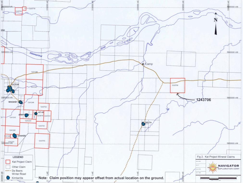
Fig 2. Kat Project Mineral Claims
•r. NAVIGATOREXPLORATION CORP
lg.
LEGEND
[~] Kat Project Claim
l j Other Claim—-- De Beers
Winter RoadV Kimberlite —Note: Claim position may appear offset from actual location on the ground
The nearest permanent accommodations to the project area are available at the motel in Attawapiskat. Freeze-up and break-up in the Project area is variable, generally occurring in November and early May, respectively. Ice-free seasons average about 7 months in duration.
2.3 Physiography, Flora and Fauna
The Kat Project area lies within the James Bay Lowlands, approximately 110km west of the shore of James Bay at roughly 54 degrees north latitude. The area is generally flat and poorly drained with 90Vo of the area covered by peat and string bogs/muskeg (Martini, 1989). Primary drainage in the area is provided by the Attawapiskat River, which drains eastward to James Bay. Elevation in the immediate vicinity of the Kat Project claims is approximately 85m above sea level. Tree growth is generally sparse with common alders and black spruce and lessor stands of poplar and jack pine. Average high and low temperatures for January are -17.80C and - 28.7 C, respectively (Martini, 1989). Summer temperatures reach in excess of 200C. Wildlife is common in the region and includes woodland caribou, moose, fox and migratory birds including waterfowl are common during the summer months. In addition, pickerel, trout and northern pike are common in many of the lakes and rivers.
2.4 Property History
The James Bay Lowlands of Ontario have been considered prospective for the presence of primary diamond deposits since the discovery of kimberlitic indicator minerals by the Ontario Department of Mines in the 1960's (Brown et al., 1967). Exploration by Selco Mining Corporation and Esso Minerals in the early 1980's led to the discovery of 45 alnoite and carbonatite intrusions within the southern portion of the James Bay Lowlands (Reed and Sinclair, 1991). The first bonafide kimberlites discovered within the James Bay Lowlands were found by Monopros Ltd. (recently renamed De Beers Canada Exploration) near the Attawapiskat River, approximately 110km west of the shoreline of James Bay (Kong et al., 1999). The discovery of 16 kimberlites by Monopros represented the culmination of an exploration program initiated in 1984. Further exploration in 1994 and 1995 by KWG/Spider Resources resulted in the identification of two additional kimberlites in the Attawapiskat cluster, as well as five older kimberlitic bodies (Kyle Lake cluster) 50 to 60km to the west (Janse et al., 1995; Novak, 2000). In February 2001 kimberlite AT-56 was discovered approximately 4km southeast of De Beers Victor pipe, bringing the total number of kimberlites discovered in the Attawapiskat cluster to nineteen (Armstrong, 2001). Government work in the area has included the release of heavy mineral sampling data along the Attawapiskat River (Morris et al., 1995) and a recent compilation/review of the kimberlites and related bodies of the Attawapiskat area (Sage, 2000).

3.0 GEOLOGY
3.1 Regional Geology
The Kat Project area lies within the 1.2 million km2 Hudson Platform of Northern Ontario (Johnston et al,, 1992). The Hudson Platform is comprised of the flat lying Paleozoic rocks of the Moose River and Hudson Bay basins, separated by the northeast trending uplands of the Cape Hentrietta Maria Arch (Figure 3). The basins consist of shallow water sedimentary sequences that unconformably overlie the Precambrian plutonic and supracrustal assemblages of the Superior Province (Moose River and southern Hudson Bay basins) and the Proterozoic rocks of the Churchill Province (northern Hudson Bay basin). The maximum depth to the Precambrian basement is approximately 800m in the central part of the Moose River basin and in excess of 1000m in the Hudson Bay basin (Johnston et al, 1992).
The Superior Province, the largest Archean craton in the world, is comprised of a series of east-west fault bounded terranes that accreted during the late Archean. Superior Province rocks underlying the Hudson Platform are interpreted to represent the granite- greenstone terranes of the Sachigo and Barrens River subprovinces. These subprovinces are comprised of linear to arcuate greenstone belts within larger felsic plutonic and gneiss domains (Thurston et al., 1992). The 2.7 to 3.0Ga rocks of both subprovinces have under gone multiple deformation events, particularly within the greenstone domains (Thurston et al., 1992). Diabase dykes related to the 2171Ma Marathon, 1888Ma Molson, and 1267Ma Mackenzie swarms are known to cut the rocks of the northwestern Superior Province (Thurston et al., 1992).
The Proterozoic rocks of the Sutton Inlier are exposed in the northern portion of the Hudson Platform. These rocks include undeformed clastic and carbonate sedimentary sequences intruded by gabbroic bodies. The rocks of the Sutton Inlier have been correlated with the Belcher fold belt of eastern Hudson Bay and the Fox River Belt in Manitoba, which are interpreted as part of the Trans-Hudson Orogen (Osmani, 1992).
3.2 Property Geologyt
The bedrock underlying much of the Kat Project area is dominated by the stromatoporoid-coral-algal reefs and interreef carbonate sediments of the Silurian Attawapiskat Formation (Suchy and Steam, 1993) (Figure 3). Outcrops of the Attawapiskat Formation rocks are best exposed in cliffs along the banks of the Attawapiskat River. The Attawapiskat Formation has an estimated maximum thickness of approximately 60m, however the underlying Ekwan River Formation limestones are exposed in some cliffs along the Attawapiskat river due to locally significant faulting (Suchy and Steam, 1993). A major episode of fault movement is interpreted to have occurred at or near the end of Attawapiskat Formation deposition and prior to deposition of the overlying Kenogami River Formation. The thick, red bed clastic carbonate and evaporite sediments of the Kenogami River Formation are extremely erosive and therefore very uncommon in outcrop in the Hudson Platform (Suchy and Steam, 1993).

However, the 2001 drilling program confirmed the local presence of Kenogami River Formation red mudstones within the Project area (Armstrong, 2001). Xenoliths of Kenogami River Formation rocks have been identified in some Attawapiskat cluster kimberlites (Kong et al., 1999).
Kimberlite volcanism represents the most recent major geological event in the Project area. High precision U-Pb perovskite ages for three of the Attawapiskat kimberlites indicate an age to 176-180Ma for these kimberlites (Heaman and Kjarsgaard, 2000). In contrast, the Kyle Lake bodies, which do not penetrate the Paleozoic cover sequences, are estimated to be approximately l lOOMa (Sage, 2000).

GEOLOGY ANDPRINCIPAL MINERALS
OF ONTARIO
Ontario
NAVIGATOREXPLORATION CORP Kat Project
Area
Major Mineral DepositsPast sr-a Prsseil
LEOEND"PHAMEROZOtC
MESOZOIC CRETACEOUS
Sadimentary racht
SOPTR/On ̂ WD SOUTHERN PflOVJ WCES NEQ-TD MESOPflOTfcHOZO)CH Felsic rnlfusivc WC*S
SILURIANSeffimernaiy raws
CAMBRIANSKSrnantar)- rocks
PRECAMBRIANARCHEAN
HEP- TO MESOARCH6ANPROTEROZOICNEO TOMESOI'flOtEROZOlC
tflmglitic (Ocks anrt g
Marie If) ultramafic ptu^ rocks
ulonic rock*, derived gn&sses ard mi o m ames
Figure 3
C 1565 Queen's Primer fat Oniorxj PrlnttO hi Onltfto.

4.0 DRILL HOLE 01-F801-01
4.1 Introduction
Drill hole 01-F801-01 was drilled from March 16, 2001 through March 19, 2001, as part of a larger exploration program conducted that winter (Armstrong, 2001). Boart Longyear Inc of North Bay, Ontario was contracted to provide drilling services for the program. An LF-70 helicopter portable hydraulic drill was used to test ten targets with 2,111m of HQ core drilling in 19 drill holes. The drill was mobilized from De Beers Canada Exploration's advanced exploration site 15km west of the Kat Project exploration camp, and was returned to that location upon completion of the program.
The Kat Project camp, constructed along the winter road linking De Beers' Victor Project with Attawapiskat, was located next to the Nayshkootayoaw River at approximately 5859000N l 320500E (NTS NAD27 coordinates, Zone 17) (Figure 2). The camp was constructed under the authority of Ontario Ministry of Natural Resources Work Permit MO-00-11. The camp was supplied by the drilling contractor and shipped to site via the winter road from Moosonee. Clearing of the camp site area was conducted by members of the Attawapiskat First Nation through Attawapiskat Technical Services. The camp was constructed by the drilling contractor, with the assistance of Attawapiskat Technical Services. All food and related provisions for the camp were purchased at the Northern Store in Attawapiskat and trucked to site via the De Beers winter road. Fuel requirements for the program were purchased through Greg's Fuels of Attawapiskat and Paytahpun Fuels of Moosonee. Shipment of fuel and other materials from Moosonee to site was provided by Moosonee Transportation Limited of Moosonee, Ontario. Helicopter support was provided by Canadian Helicopters of Les Cedres, Quebec. Helicopter support included the use of a Bell 206 Longranger as well as an Astar 350BA.
Details relating to allowable assessment work expenditures associated with this work are provided in Appendix I. As this work was conducted more than 24 prior to this assessment filing, expenditures being applied consist ofSO'Yo of the original allowable exploration costs. A listing of project personnel is provided in Appendix II.
4.2 DDH 01-F801-01
Drill hole 01-F801-01 was spotted at the centre of the magnetic anomaly outlined by the ground geophysical survey at grid coordinates 0+OON and 5+OOE (UTM 5856534N/324340E) (Appendix III). Drilling commenced on March 16 and was completed March 19. The vertical drill hole was intended to test the deep seated magnetic feature defined by the ground magnetic survey. The magnetic body was explained by the presence of strongly magnetic sulphide iron formation in the Precambrian basement,

288m below the present surface. Drilling was terminated at 317.5m in oxide/sulphide iron formation. A detailed drill log for 01-F801-01 is provided in Appendix III.
5.0 CONCLUSIONS AND RECOMMENDATIONS
Drill hole 01-F801-01 explained the source of a deep seated magnetic anomaly as sulphide-rich iron formation. The drill core is stored and the drill site, with the exception of the section from 286.15m to 317.5m wihin is stored at the site of the Kat Project exploration camp.
Costs relating to this work should be filed for assessment credit.
Kenneth A. Armstrong December 12,2003

REFERENCES CITED
Armstrong, K.A., 2001. Kat Project, Attawapiskat, ON (Porcupine Mining Division)Report on exploration activities. Ontario Ministry of Northern Development and Mines Assessment Work Report 2.22569 by Navigator Exploration Corp l Canabrava Diamond Corp.
Armstrong, K.A., 2002. Kat Project, Attawapiskat, ON (Porcupine Mining Division)Report on exploration activities. Ontario Ministry of Northern Development and Mines Assessment Work Report 2.23906 by Navigator Exploration Corp l Canabrava Diamond Corp.
Brown, D.D., Bennett, G., and George, P.T., 1967. The source of alluvial kimberlite indicator minerals in the James Bay Lowland. Ontario Department of Mines, Miscellaneous Paper MP.7, 35p.
Heaman, L.M. and Kjarsgaard, B.A., 2000. Timing of eastern North American kimberlite magmatism: continental extension of the Great Meteor hotspot track? Earth and Planetary Science Letters, 178:253-268.
Janse, A.J.A., Novak, N.A., and Macfadyen, D.A., 1995. Discovery of a new type of highly diamondiferous rock in the James Bay Lowlands, northern Ontario, Canada. Sixth International Kimberlite Conference Extended Abstracts, pp260-262.
Johnston, M.D., Armstrong, D.K., Sanford, B.V., Telford, P.G., and Rutka, M.A., 1992. Palaeozoic and Mesozoic geology of Ontario; in Geology of Ontario, Ontario Geological Survey, Special Volume 4, Part 2, pp.907-1010.
Kong, J.M., Boucher, D.R., and Scott Smith, B.H., 1999. Exploration and geology of the Attawapiskat kimberlites, James Bay Lowlands, Northern Ontario, Canada; in The J.B. Dawson Volume: Proceedings of the Vllth International Kimberlite Conference (Vol.1), pp.452-468.
Martini, I.P., 1989. The Hudson Bay Lowland: major geologic features and assets. Geologic en Mijnbouw 68:25-34.
Morris, T.F., Bajc, A.F., Bernier, C.A., Kaszycki, R.I., Murray, C., and Stone, D., 1995. Kimberlite heavy mineral indicator data release. Ontario Geological Survey, Open File Report 5934, 91p.
Novak, N.D., 2000. Kyle Lake #1, case study, a multi-phased diamond carrier? InAbstracts for diamonds in Eastern Canada, Toronto Geological Discussion Group, pp.TDGD12-TDGD15.
10
Osmani, LA., 1992. Proterozoic mafic dike swarms in the Superior Province of Ontario; in Geology of Ontario, Ontario Geological Survey, Special Volume 4, Part l, pp.660-681.
Reed, L.E. and Sinclair, I.G.L., 1991. The search for kimberlite in the James Bay Lowlands of Ontario. CIM Bulletin 84:132-139.
Sage, R.P., 2000. Kimberlite of the Attawapiskat area, James Bay Lowlands, northern Ontario. Ontario Geological Survey, Open File Report 6019, 314p.
Suchy, D.R. and Steam, C. W., 1993. Evidence of a continent-wide fault system on theAttawapiskat River, Hudson Bay Platform, northern Ontario. Canadian Journal of Earth Sciences 30:1668-1673.
Thurston, P.C., Osmani, LA., and Stone, D., 1992. Northwestern Superior Province:review and terrane analysis. In: Geology of Ontario, Ontario Geological Survey, Special Volume 4, Part I, pp.81-144.
li

DECLARATION
I, Kenneth A. Armstrong, certify that:
1. I am a practicing member of the Association of Professional Geoscientists of Ontario (#0651).
2. I have been conferred with the academic degrees of Honours Bachelor of Science - Geology (The University of Western Ontario, 1992) and of Master of Science - Geology (Queen's University, 1995).
3. I am currently employed with Navigator Exploration Corporation of 1300-409 Granvillf Stfe^t, Vancouver BC, V6C 1T2, and have been since 2000.
'" " ' " "
Kenneth-^.. ArrH December, 2003""
12

APPENDICES
Appendix I Project Cost ScheduleAppendix II List of Contractors and Project PersonnelAppendix III Drill log, plan, and section - DDK 01-F801-01
13

Appendix I
Project Cost Schedule
Statement of Expenditures (2 pages)
The following statement of expenditures covers allowable assessment costs incurred on the Kat Project between January 01, 2002, and November 30,2002. The statement is the same as was filed in Armstrong (2001) when reporting other work conducted during this program. Several of the Schedules included with the original submission are not included here. Total expenditures relating to the completion of DDK 01-F801-01 are 564,823. However, as more than 24 months have passed since the completion of this work the total allowable expenditures that can be applied are S32,411. None of these expenditures have been applied in previous assessment filings.
Total expenditures are 532,411. This figure has been applied on the Form's 0241 and 0212 submitted with this report.

KAT PROJECT
Statement of Eligible Expenditures Incurred on the Kat Project between January 1, 2001 and May 24, 2001
Description Reference Amount
2001 Winter Program
Helicopter; Astar BA Helicopter; 206L
Diesel FuelGasolinePropaneCamp RentalCamp CookCommunicationsCamp mob/construction*
Canadian Helicopters; 370.6 hours*Canadian Helicopters; 48.1 hours*"includes charter rate plus S318.357hour fuel, see shedule BPaytahpun Fuels; 106 drums x S243.58Paytahpun Fuels; 4 drums x S280.25Paytahpun Fuels; 20 x 100lb bottles x S204.50Boart LongyearBoart LongyearGlobalstar TelephoneLongyear/Attawapiskat T.S., Moosonee Transport
'includes site preparation/clearing, shipping from Hailybury, labourAttawapiskat accom.FoodDrilling; ContractorDrilling; ShippingPersonnel mob/demobProject GeologistProject Manager/SupervisorLine CuttingGeophysicsSupplies/Expediting
Okimaw's Motel Northern Store Boart Longyear Moosonee Transportation Ltd Calculated in Armstrong (2001) Calculated in Armstrong (2001) Calculated in Armstrong (2001) Calculated in Armstrong (2001) Calculated in Armstrong (2001) Calculated in Armstrong (2001)
382,959.5152,830.64
25,819.481,121.004,090.00
37,200.0012,000.0010,501.9245,295.07
10,010.0018,360.56
238,481.431,689.15
15,599.2624,997.9225,900.0023,850.0013,189.68
__3,836.26Total $ 947,731.88 947,731.88
Total Regional Expenditures: 947,731.88

KAT PROJECT
Schedule E - Drilling Costs
Description Reference Amount
Direct Drilling Expenses:
Drilling; Contractor Drilling; Shipping Drilling; Site Preparation Diesel Fuel Propane
Boart LongyearMoosonee Transportation Ltd.Silverspruce; 3 mandays45 drums x S243.5810 x 100lb bottles x 3204.50
"Direct drilling expenditures per metre (2,111 total metres):
Support Related expenditures:
Helicopter; Astar BA Helicopter; 206L Room and Board Mob/Demob Geologist Project Manager
313.1hrsxSH35.66 3.6hrs x S1200.66 286 man days x S261.50 5 men x S1,418.11 K. Armstrong B. Mosher 50 07o
•Drilling support expenditures per drill hole (19 total):
238,481.431,689.15
600.0010,961.102,045.00
Subtotal S 253,776.68
120.22
355,574.184,322.36
74,788.797,090.57
41,321.4923,334.53
Subtotal S 506,431.93
26,654.31
253,776.68
506,431.93
Total Drilling related allowable expenditures: S 760,208.61
Expenditures related to drilling targets reported herein:
Target F801(DDH 01-F801 -01; 317.5m)
Direct drilling expenditures (317.5m x S120.22) = 38,168.69Drilling support expenditures (1 drill hole) =____26,654.31
F801 total drilling expenditures = S 64,823.00
Total allowable expenditures for 2003 filing (500Xo) s S 32,411.50
____Total Drilling related allowable expenditures applied herein = S 32,411.50
'These are the same values applied to previously reported drilling relating to this program (Armstrong, 2001)

Appendix II
List of Contractors and Project Personnel
List of Contractors
Contractor
Boart Longyear
TVDC of Work
Drilling Contractor
Address
P.O. Box 33
Attawapiskat Technical Services
Silver Spruce Exploration
R.J. Meikle SL Associates
Johnston Geophysics
Canadian Helicopters
Paytahpun Petroleum
Camp Construction l Line Cutting
Line Cutting l Grid Construction
Geophysical Operator
Geophysical Processing
Helicopter Charter
Fuel Purchases
Moosonee Transportation Ltd. Shipping/Receiving
Okimaw's Motel
North West Company
Commercial Aviation
Air Creebec
Additional Contacts:
Navigator Exploration Corp.
Canabrava Diamond Corp.
Accommodation
Food Purchases
Air Transportation
Transportation/Shipping
North Bay, ON PI B 8H6
P.O. Box 248 Attawapiskat, ON POL l AO
R.R.#1 Fielding Station Connaught, ON PON l AO
707 Ski Club Road North Bay, ON PI B 7R5
1226 Gatineau Blvd. Timmins, ON P4R l E3
1215MonteePilon LesCedres,QCJ7TlGl
P.O. Box 27 Moosonee, ON POL 1YO
P.O. Box 156 Moosonee, ON POL l YO
P.O. Box 135 Attawapiskat, ON POL l AO
77 Main St.Winnipeg, MB R3C 2R1
P.O. Box 460 Hearst, ON POL l NO
R.RJ2Timmins, ON P4N 7C3
1300-409 Granville St, Vancouver, BC, V6C 1T2
P.O. Box 10102, 1650-701 W. Georgia St., Vancouver, BC, V7Y 1C6

List of Personnel
NameK. ArmstrongB. MosherE. Korba
S. Poulsen
L. GagnonG.Fireman
R. MeikleL. BlanchardB. DucetteS. LarocqueD. WainmanJ. HillCookHelicopter PilotHelicopter Pilot
Helicopter Engineer
Mandays577437
31
3115
3235959555555526723
74
PositionProject GeologistProject ManagerLine Cutter 1 StakerLine Cutter 1 Mag OperatorLine CutterLine Cutter
Mag OperatorDrill ForemanRunnerHelperRunnerHelperCookAstar Pilot206L Pilot
Engineer
CompanyNavigatorNavigatorSilver Spruce
Silver Spruce
Silver SpruceAttawap. Tech. ServicesMeikle SL Assoc.LongyearLongyearLongyearLongyearLongyearLongyearCanadian Heli.Canadian Heli.
Canadian Heli.
Dates of Work*Feb. 1 - Mar. 30Jan. 15 -Mar 30Jan. 15- Feb21
Jan. 15- Feb. 15
Jan. 15 -Feb. 15Jan. 15 -Jan. 30
Jan. 30 -Feb. 21Jan. 30 - Mar. 30Jan. 30 -Mar. 30Feb. 2 - Mar. 29Feb. 2 - Mar. 29Feb. 2 - Mar. 29Feb 5 - Mar. 29Jan. 22 -Mar. 30Jan. 15 -Jan. 21 Feb. 6 - Feb. 22Jan. 15 -Mar. 30
*Dates of work cover the entire program including time spent performing work not reported for assessment credit.
Appendix III
Drill Log, Plan, and Section - DDK 01-F801-01
Drill Log (2 pages)Drill Plan (l page)
Drill Section (l page)

KAT PROJECT DRILL LOG : 01-F801-01
Drill Hole: 01-F801-01 Date Started: Mar 16, 2001
Dip: -900 Date Completed: Mar 19, 2001
Azimuth: N/A Core Size: HQ
Max. Depth: 317.5m Logged By: K. Armstrong
Position - Date Logged: Mar 19/01
Datum: NAD 27 Drill Contractor: Boart Longyear Inc.UTMN: 5856534N Drill Type: LF-70UTM E: 324340E Core storage: to 286.15m at Drill SiteZone: 17 286.15 to 317.5m at Camp
Grid Name: F801 Target Name: F8-01Grid N: BLGrid E: 5+OOE Date Log Completed: Nov 1,2001
Claim #: 1243706

0.0 - 3.0m Overburden
3.0 - 288.3m Paleozoic Limestone (Undifferentiated)
288.3 - 317.5m Oxide/sulphide Iron Formation
EOH
Target Explanation: Strongly magnetic iron formation explains the deep magnetic response of the target
Casing was retrieved
01-F801-01 Detailed Log
0.0 - 3.0m Overburden
3.0 - 288.3m Paleozoic Limestone (Undifferentiated)
The Paleozoic stratigraphy was not logged in detail above 286.15 metres.
288.3 - 317.5m Graphitic Oxide/Sulphide Iron Formation
This unit is highly altered down to ~297m, with most sulphides and magnetite altered to bright yellow and red clays with significant graphite. Most of the magnetism and original rock fabric is gone from the rock. It is most likely that this upper portion of the unit was altered by penetration of overlying sea waters, as suggested by the presence of carbonate stringer-like veinlets in this part of the section. This is a very pretty rock.
297 - 306m: The rock displays a decrease in the alteration of sulphides and magnetite to bright yellow and red clays and a significant increase in graphite content (locally exceeding 50*5-0 of the rock). The rock is black in colour, more dense, contains unaltered sulphides (py + po), and becomes more magnetic with depth.
306 - 317.5m: The rock over this interval is prominently banded, with the banding made more pronounced by pyrite/pyhrrotite bands. The bands are oriented at 200 to the core axis. The sulphide bands actually occur more as stretched out rods or pencils, elongated in the direction of the banding and locally boudinaged. Pyhrrotite content increases down section, often occurring at the centre of the sulphide rods with an outer white quartz rim. This latter feature is not always well developed. Sulphides compose up to 25 07o of the rock near the base of the section, with the remainder composed of graphite, magnetite and quartz. Significant fine grained amphibole may also be present. Fractures at the bottom of the section show slickensides parallel to the core axis.
EOH
Casing was retrieved

01-F801-01
Kat Project Claim
Other Claims
Collar Location
Kat Project 01-F801-01 Drill Hole Location
Angle: 90 deg Azimuth: N/A Core Size: HQ Easting: 324,340 Northing: 5,856.534
NAVIGATOREXPLORATION CORP

Ill6
t
J
mAngleAzimi
-----.-. - CoreEastir North
UIE
,
Overburden
Paleozoic Limesto (undifferentiated)Oxide/Sulphide Iro Formation
: 90 deg jth: N/A Size: HQ ig: 324,340 ng: 5,856,534
......................... .......... .^
lil i ui ui
m K S **•* c\ ^ ^IN \J Oil (Mm k ^ w rt
0V
ne
n
Kat Project Section 01-F801-01
Data. DBC 2003 .
W-Author M -^r^S
——————————— Tff
Or. 01-F801-01 ~7W
Scale l 1500 '
^NAVIGATORJ^TEXPLORATION CORP. ~""" 'r^ k***J*
0 30 60m
***n ww.**,
—
C3
^
1-F801-0117.5m
^..............,...-............™.......,......
...............................I.OPm.^s!....
80m asl
.............. ....................Pjs.aal...
. ... -40masJ
.............................IfiQnx^L....
-16pm as)
..............................JfiteaajiL...

ONTARIO MINISTRY OF NORTHERN DEVELOPMENT AND MINES
Transaction No: W0360.01985
Recording Date: 2003-DEC-17
Approval Date: 2003-DEC-19
Work Report Summary
Status: APPROVED
Work Done from: 2001-MAR-16
to: 2001-MAR-19
Client(s):
302368
Survey Type(s):
CANABRAVA DIAMOND CORPORATION
PDRILL
Work Report Details:Perform Applied Assign Reserve
Perform Approve Applied Approve Assign Approve Reserve Approve
P 1243706 332,411 532,411 532,411 532,411 SO O SO SO
Claim*
532,411 532,411 532,411 532,411
50
SO SO
SO
SO
Due Date
SO 2008-DEC-27
SO
External Credits:
Reserve:
50
50 Reserve of Work Report#: W0360.01985
SO Total Remaining
Status of claim is based on information currently on record.
43B13SE2005 2.26859 BMA 527 833 900
2003-Dec-30 15:07 Armstrong-d Page 1 of 1

Ministry ofNorthern Developmentand Mines
Date: 2003-DEC-22
Ministere du Developpement du Nord et des Mines Ontario
GEOSCIENCE ASSESSMENT OFFICE 933 RAMSEY LAKE ROAD, 6th FLOOR SUDBURY, ONTARIO P3E 6B5
CANABRAVA DIAMOND CORPORATION STE. 1650. 701 WEST GEORGIA STREET VANCOUVER, BRITISH COLUMBIA V7Y1C6 CANADA
Tel: (888) 415-9845 Fax:(877)670-1555
Dear Sir or Madam
Submission Number: 2.26859 Transaction Number(s): W0360.01985
Subject: Approval of Assessment Work
We have approved your Assessment Work Submission with the above noted Transaction Number(s). The attached Work Report Summary indicates the results of the approval.
At the discretion of the Ministry, the assessment work performed on the mining lands noted in this work report may be subject to inspection and/or investigation at any time.
If you have any question regarding this correspondence, please contact STEVEN BENETEAU by email at [email protected] or by phone at (705) 670-5855.
Yours Sincerely,
Ron C. GashinskiSenior Manager, Mining Lands Section
Cc: Resident Geologist
Canabrava Diamond Corporation (Claim Holder)
Assessment File Library
Canabrava Diamond Corporation (Assessment Office)
Navigator Exploration Corp. (Agent)
Visit our website at http://www.gov.on.ca/MNDM/LANDS/mlsmnpge.htm Page: 1 Correspondence 10:18984

43B13SE2005 2.26859 BMA 527 833 200ONTMIIOCANADA
MINI8TBV OF NORTHERN DEVELOPMENT AND MINES
PROVINCIAL MIMING KECORDEH'S OFFICE
Mining Land Tenure Map
3200006;'"~M'|...-- jfr, ,' •-"30Hte4'..',r, **'K 1 " - l , -L-j ',. L,1 , - ™ -" . i .,"..'.t] v "-
325000E•*w- . Alt— •.-•itfe-—- -wf ...-.. ":ite- -- -^y.;.---"" 'S*' ...-.- -NsJ//. ••••- -Site " - -s*;- ...... - sUfe- — -^^ife—- -SK- ...-. -tr^iip'̂.T.^Jfe "-'-'-'Tr -.'-'•'-. "•'"^ 1-:—.''\7,^: •.:. i:-.:"',7 ..-•-i "T "*fe ^.'":,:'*J,SAfc •...-.•..-".y —.v. ".5" "ife '.::*v'7ivi?:;" .:.v;:'7j- ...'.y. -.'r •'• : T;;|" Afe: '"••-" 4"H ** "'* -"fe;.'.".^: '--"" ^ •;!' - -" ";'*' '-"f''"* "•'•'•"" :'*'. ; * - "?fe '"'!v"^'- '" ;" ; " *': '
SMOOOON
-3004021
*"'""'"Cixite^'^f^^lliii?•-:.----;i;?^: ••™rur "^^™ii "';*' ;.:.c-.i''^:•::":-;i fi:"r*•'••ivTi.;^-^;i"' '^','::*'l:^if :::^a,
^SSSs^S-
fi'aoiBS^^:
1)807(^1" ':.:. ; .
" jm
" MI: v;/^
"" ^i,1 "" ^i , "t s*":,",, '""" i.l.'r'v^ t/ -.r--.. ';sWf .. .;:;- ..j,,^,.. 'j.-.-":'
B ""V",,.,u'}(. s d- B:'" i "^Lr'Ur ..... 'VW- ". '"V-.. ^J;'' ..-i
V):;vk' T,'"'":-:";!"',^;"^^!- SSJ/' " V:'v7.r.,,;~". , jji!;^;""":. - ^
' 30)6217- v :,;""""',jqTCi8a"1- -: ."". i;" 1 ::;'.'; v'^" r|';^'-"-';-''^J ;:; 'i.v;"-^ -^
L'""^-"'.,;J,.,' ,".\.:" vjt ^":!;:' i ";*;; il 1 ;;.:, "-If,;";.^ '.T:'.V *}i"'-^.^"sfc: "^'"':^: }~~:" '"'l:v'" •^'•.y^ji: '.7:'i ; ' "\:-,k- '.''''-.- ""^ ' -w." siifc '^i; ',"":v!.k; '™" -4? '. •^•"sSk-. ""•''-.""sJ.fe "'^.v" sfc 1 -...•.,, - ,.-. ,i, 'V.. ; ;.-m •-•. ,..;.-..; —\ ... ,|., •..-....'.:;,. j r. ..::.. 'r: - .;-- .i. -- :.;.-. """ -...'-. "" -" t.-.:-.—-.. -:::, ,"--~- "T". ,--' .i. :..-.':-~ 't:, f-:-, "r:, ..-. ii, -!:i*fr.-r""L,-..^Js'. '"-'""' •'-••;:~"l;."J'?'Jfe;T'i;.:.S;fe "'"" -v--~" I:,;,,Ate:;~""L:,:.,;'ifc' "'Tl '" •'.'•~::"' '^...M;'.""!:.,1 ,- ; fe;: : ^"T" "•;; "::"!L,'.,.'*fe;:7"!L:., :Wft'' "'-'" -;': "i"" "I,:,Vl4::r"",-:.. :W '- r '"vJ'; '*:i "'""l v4Lv' '™' : 7"",;" r~ ; ' .•L -AV!r i . : l! ';. - *5,*;""i'::: "-Y.";.:'"t. ; AJ.6-"1'":1 . -. ^.w-' '.•"'•/"'-V'/""'". ' ;y!;: f"'""'!.,, 1 . ~V:'' : ' :"';""^"::" i ";',.';?!fe:i"l.; ^••"^•"••^";:?' iv.;..'ViJfe :iJ "k:.^f'-"l'''r'-"''-
- ' ••: i i/.' "~" '.' :"~:::'\:\t.' ••••••vllfr -" '.', 'r";;: xik' ;.r- viy ,:;,1 — " ';.v.S.'-' -- - ' v,i,v •••-••.'. ,!~"":;:'sjy/ ::::;. - 'Ab:/: -:::,,: -,'..,-"":.: riux ,:r '. - '- :Jk' ,":~. ;" .,i"';-.,:: vii" 'r:.^^".--. M!.V ;:'~; ^ 1::: ?^*: .'-'.-- ^ .7-^ :*!# :7'" ; ''-*' -" ••• : - *j:'; ' 'v--. ^s' "•'; W' . ; :::: *k ..:v::;; ^ .;:::. ^ :." ,::; sk :^:i ^ .r,., 4s'
''""' ' J " * ' ''i i "'' ' ' '•" i ' '''w'' '' Vi11" " ' 'u i -\' ' ''•'"'•' "* !* ".i lv,1 '"•*"" NXw'r - ' '"'" * 'v"1 1/*1 ".t," i-" * ,,\l f. ; ,'*'." , ,x,ifCi;' ,. '' ( ' ™ ,', l h , ' ',*'.' ""''' ,, 'i: ,\. ","" ^ ''\!J,t|i;' ** '*" " \\ f i' ( f "v""*' n '"'" *a 'ii c/ "~^,, ,'\VM'i ' ' * ' * '•'i \f~' '"'" '"" " \\! ''" "**"*, . i'jMO;' i '.j"" ^^'Vw- '",. ! ."•s-v ^ ..., , vry..,, ,. \,"" j iKW;;, ,^, ii- ... \f" t"-' .?,WiS i , ^. ,i n "" - .Six*- . :;.... . "v ' , ( ';'" * ^v^ i ^. ,* ",,' v..v,':'v:, , -. ,. ' ^-' ( -.,,., .^yv/, ,; ..,;;,™w" . Wfe. ,; .^., '^" "" i( * .~j^*.fc. i J..-J'" ' '&VX4' r;,..,, ""''
{ , ' "~ "''" :-* "- ""' ' '' , p , l "-" ' '' , J , K "B" ™"" .1 " 'f ' — l- ' . J , *'"*t " , l . '"""l "' ' "" " * "' ' "' , t . ——, ,,. . '" , . ", '"- 1 " ' '' " " W |'V",. ', .( ( ,. , ""ft ' ^ m ;'n K i , t ""l"" ,.^'j'" "" * '™';,' n , ', 1} j J. , "'"" " ,,,,/, . j f. , '' K "' ,,, TO ™** '"" * '
MSOOtlEUTM Zona 17 5000m arid
Thoae wishing to stake mining duima should consult with the Provincial Mlnins RecorrJera' Office oi the Ministry of Northern Development and Mines for additional General information and Limitations information on the status of the landu shown hereon. Thismnp Is not intended for navigational, survey, or land title determination purposes as the information Contact Information: shown on this map fs complied from various source*. Completeness and accuracy are not guaranteed. Additional information may also be obtained through the Provincial Mining Recorders' Office local Land Titles or Registry Office, or the Ministry of Nature! Resources.
Toll Free Map Datum: NAD 83 Tel: 1 (888)415-6846 ext S7tajjection: UTM (6 deoree)
Willet Green Miller Centre 933 Ramaey lake Road fax: 1 (677) 670-1444 Topographic Data Source: Land Information Ontario Sudbury ON P3E 6B5 Mining Land Tenure Source: Provincial Mining Recorder^ Office
The Information shown la derived from digital data available in the Provincial Mining Recorders' Office at the time of downloading from the Ministry of Northern Home Page: www.mndm.9av.Qn.ca/MNDM/MINES/LANDS/mlsmnpge.htm DffyslopmenS and Mines web site,
This map may not show unregistered land tenure and interests in land Including certain patents, leases, easements, right of ways, flooding rights, licences, or other forms of disposition of rights and Interest irom the Crown. Also certain lend tenure and land uses that restrict or prohibit frea entry to stake mining claims may not be Illustrated.
Date; Time of Issue: Mon Dec 22 09:10:44 E8T 2003
TOWNSHIP l AREA PLAN BMA 527 833 AREA G-3842
ADMINISTRATIVE DISTRICTS l DIVISIONSMining DivisionLand Titles/Registry DivisionMinistry of Natural Resources District
Porcupine KENORA COCHRANE
TOPOGRAPHIC
: Adrflinistrafive Boundaries
i" " ; Township
; Concession, Lot
l!
K
A
Indian Reserve
Ctiff, PH * PJte
Contour
Mine S^fte
Railway
FUUKl
Tmil
Nalursl Gas Plpalfm
UMta
Tower
Land Tenure
Freshold Patent
fi'"! Surface And Mining Rigrtte
A SurlaM Rl4)Mt Only
f i"] Mining Riahts Only
Surfnt* *nd Mlnlnj RJgtitt
Fin Mtntng Rights Oily
licence of Ocaipoton
riv""l Uses Mot SpecifiiKJi v '
Surface And Mining Rigrtts
Surtec* Rights onty
Miorng RiflihlK Only
Land UM Permit
Dfder In Councf) (Not open cor staking)
Wfrtw Poww Lease Agre*mant
Mining Claim
Filed Only Mining Claims
UNO TENURE WITHDRAWALS
4 : ; i *ma* W*h*awti Irnro DisnrWIInnk,,,j Mwn^ ^^ Withdrawal TypetWsm Kurtace And Mining Rights WithdrawnWs SurtKeWjMsOBlyWltlidtmnWm Mining KtQMs OHy mhdtmvi'
CWw In Council wiiMrww) TypmWorn tKtoot And Mnlng Rial* WUhHtownWDft Sunace Rianls Only VfflhdnawflW"m Mininy ffiHhls Only Withdrawn
IMPORTANT NOTICES