Embed Size (px)
Citation preview

FEMA 311WB May 2003
RSDE FIELD WORKBOOK
National Flood Insurance Program
PREPARING STRUCTURE INVENTORIES USING RESIDENTIAL SUBSTANTIAL DAMAGE ESTIMATOR SOFTWARE PROGRAM
RSDE 2.0
Issued by the
Federal Insurance and Mitigation Administration Federal Emergency Management Agency
RSDE Field Workbook
TABLE OF CONTENTS
SECTION Page
ABBREVIATIONS AND DEFINITIONS.............................................................iv
1.0 INTRODUCTION ...................................................................................................11.1 Workbook Purpose and Contents.................................................................11.2 Important Assumptions ................................................................................2
2.0 BACKGROUND INFORMATION: SUBSTANTIAL DAMAGE AND RSDE SOFTWARE .......................................................................................32.1 Review of NFIP Regulations And Substantial Damage Requirements .......3
2.1.1 Review of the NFIP Requirements for Substantial Damage ...........32.1.2 What Does Substantial Damage Mean?...........................................32.1.3 Substantial Improvement .................................................................42.1.4 Implications of Substantial Damage and
Substantial Improvements................................................................42.2 Review of The RSDE Software ...................................................................5
2.2.1 Advantages of the RSDE Software ..................................................62.2.2 Review of the RSDE Software and Guidance Manual ....................72.2.3 Significant Construction Components .............................................8
3.0 PRE-DISASTER PLANNING ..............................................................................103.1 Prepare Community Policy and Action Plan .............................................10
3.1.1 Select RSDE Coordinator ..............................................................103.1.2 Community RSDE Policy..............................................................113.1.3 Develop an Action Plan .................................................................13
3.2 Identify Available Resources.....................................................................133.3 Review FIRMs and Other Community Maps ............................................153.4 Tax Data .....................................................................................................153.5 Review the Housing Stock .........................................................................173.6 Pre-enter Available Data into RSDE Software ..........................................17
4.0 AFTER THE DISASTER – WHAT NEXT? .........................................................184.1 Homeowners Can Begin Structure Clean-up .............................................184.2 Five Steps to Planning the Substantial Damage Inventory........................19
4.2.1 Step A: Select RSDE Coordinator .................................................194.2.2 Step B: Identify General Limits of Impacted Area(s)....................204.2.3 Step C: Perform a Curbside Review of Houses
to be Included in Inventory............................................................204.2.4 Step D: Define the Scope of the Inventory....................................234.2.5 Step E: Final Planning ...................................................................23
i
RSDE Field Workbook
5.0 FIELD PREPARATIONS .....................................................................................255.1 Inspection Teams .......................................................................................255.2 Pilot RSDE Inspections ..............................................................................26
5.2.1 Field Training.................................................................................265.3 Addresses ...................................................................................................265.4 Photographs ................................................................................................275.5 Resident Interaction ...................................................................................285.6 Preparing for Data Entry into RSDE Software ..........................................29
6.0 RSDE FIELD INSPECTION AND DATA COLLECTION.................................316.1 Rate of Inspections.....................................................................................316.2 Record General Data ..................................................................................316.3 Exterior Inspections ...................................................................................32
6.3.1 Measuring Building Dimensions ...................................................326.3.2 Exterior Damage to Look For ........................................................32
6.4 Interior Inspections ....................................................................................346.4.1 General Inspection Guidelines.......................................................346.4.2 Upgrades or Custom-Designed Items ............................................356.4.3 Interior Damage to Look For .........................................................35
6.5 Completing RSDE Data Entry...................................................................356.5.1 File Folders for RSDE Inventory Data ..........................................386.5.2 Processing and Storing Photographs..............................................38
7.0 POST-DETERMINATION ACTIVITIES ............................................................407.1 Substantial Damage Determination Letters ...............................................407.2 Revising RSDE Determinations Based on Homeowner Data ...................41
LIST OF TABLES
Table 2-1 Benefits and Limitations of RSDE Software..........................................6
Table 3-1 Data Resources to Assist in Substantial Damage Determinations .......14
Table 3-2 Tax Data Used in the RSDE Software .................................................16
Table 4-1 RSDE Coordinator Responsibilities .....................................................19
Table 4-2 Inspection Rates for Damaged Structures ............................................23
Table 6-1 Specific Features to Evaluate During Exterior Inspections..................33
Table 6-2 Specific Features to Evaluate During Interior Inspections .............36, 37
ii
RSDE Field Workbook
LIST OF APPENDICES
Appendix A FORMS and CHECKLISTS
Blank RSDE Damage Inspection Worksheets – Single/Multi-FamilyBlank RSDE Damage Inspection Worksheets – Manufactured HomesChecklist 1 – Pre-Disaster PlanningChecklist 2 – Field PreparationsPhoto Log
Appendix B SAMPLE DOCUMENTS
Photo Page with CaptionsLetter of Introduction (LOI)Determination Letter – No Substantial Damage (NSD)Determination Letter – Substantial Damage (SD)Recommended Guidelines for Contact with Residents
iii
RSDE Field Workbook
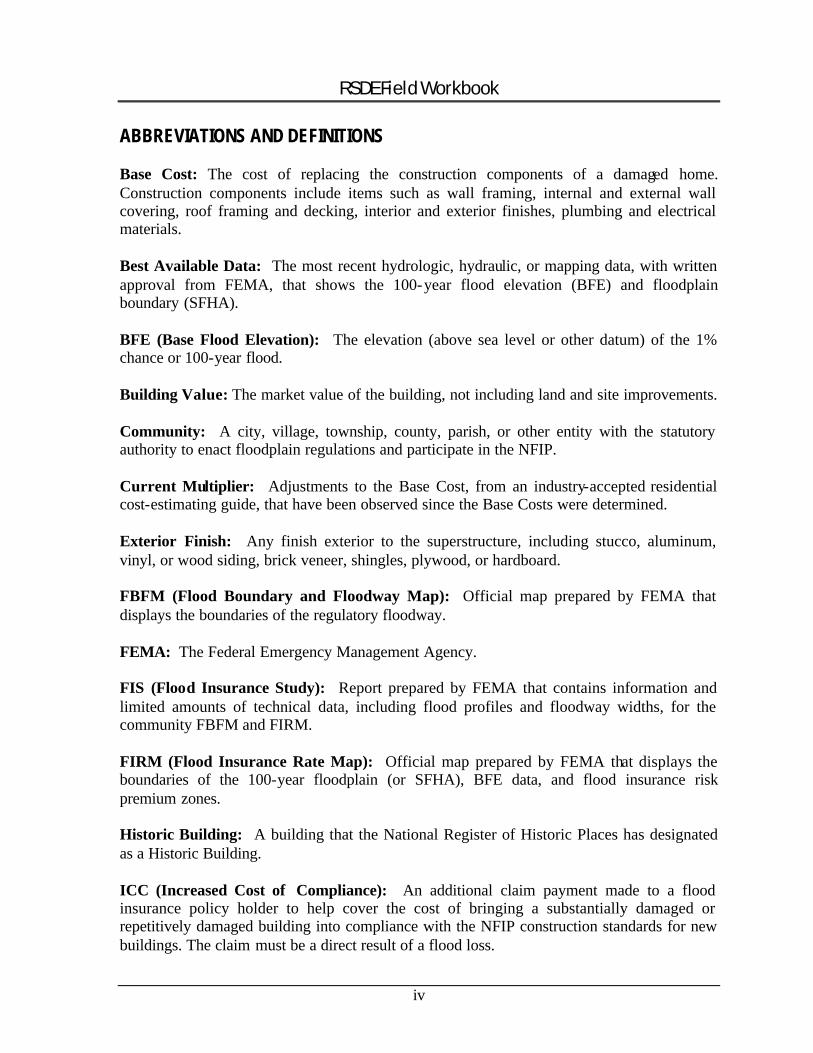
ABBREVIATIONS AND DEFINITIONS
Base Cost: The cost of replacing the construction components of a damaged home. Construction components include items such as wall framing, internal and external wall covering, roof framing and decking, interior and exterior finishes, plumbing and electrical materials.
Best Available Data: The most recent hydrologic, hydraulic, or mapping data, with written approval from FEMA, that shows the 100-year flood elevation (BFE) and floodplain boundary (SFHA).
BFE (Base Flood Elevation): The elevation (above sea level or other datum) of the 1% chance or 100-year flood.
Building Value: The market value of the building, not including land and site improvements.
Community: A city, village, township, county, parish, or other entity with the statutory authority to enact floodplain regulations and participate in the NFIP.
Current Multiplier: Adjustments to the Base Cost, from an industry-accepted residential cost-estimating guide, that have been observed since the Base Costs were determined.
Exterior Finish: Any finish exterior to the superstructure, including stucco, aluminum, vinyl, or wood siding, brick veneer, shingles, plywood, or hardboard.
FBFM (Flood Boundary and Floodway Map): Official map prepared by FEMA that displays the boundaries of the regulatory floodway.
FEMA: The Federal Emergency Management Agency.
FIS (Flood Insurance Study): Report prepared by FEMA that contains information and limited amounts of technical data, including flood profiles and floodway widths, for the community FBFM and FIRM.
FIRM (Flood Insurance Rate Map): Official map prepared by FEMA that displays the boundaries of the 100-year floodplain (or SFHA), BFE data, and flood insurance risk premium zones.
Historic Building: A building that the National Register of Historic Places has designated as a Historic Building.
ICC (Increased Cost of Compliance): An additional claim payment made to a flood insurance policy holder to help cover the cost of bringing a substantially damaged or repetitively damaged building into compliance with the NFIP construction standards for new buildings. The claim must be a direct result of a flood loss.
iv
RSDE Field Workbook
Local Multiplier: Adjustments to the Base Cost, from an industry-accepted residential cost-estimating guide, which recognize regional differences in construction costs.
Manufactured Home: A structure that is transportable in one or more sections, built on a permanent chassis, and designed for use with or without a permanent foundation when attached to utilities. The term includes mobile homes and doublewide manufactured homes.
NFIP: The National Flood Insurance Program.
Quality: Quality of the original construction of a building. Quality is defined within an industry-accepted residential cost-estimating guide.
Reconstruction: Building or repairing a new structure on the old foundation or slab of a structure that was destroyed, damaged, purposefully demolished, or razed. The term also applies when an existing structure is moved to a new site.
Refinements: Adjustments to the Base Cost that include additional building features (fireplaces, upgraded flooring, etc.) that are not part of the basic building as defined by the unit costs, including physical improvements to the main building that either protect the building or significantly enhance its habitable functions. Relative to refinements, “Roofing” implies the final surface application (i.e., shingles, tiles, metal decking, etc.). Refer to an industry-accepted cost-estimating guide for further information.
SFHA (Special Flood Hazard Area): The 100-year or base floodplain displayed on FEMA maps.
Square Footage: Square footage equals the area of the building’s footprint multiplied by the number of stories above ground. Area can simply be defined as the total living space, excluding basement or garage areas.
Substantial Damage: Damage of any origin sustained by a structure whereby the cost of restoring the structure to its pre-damaged condition would equal or exceed 50 percent of the market value of the structure before the damage occurred.
Substantial Improvement: Any reconstruction, rehabilitation, addition, or other improvement of a structure, the cost of which equals or exceeds 50 percent of the market value of the structure before the “start of construction” of the improvement. For the purposes of this definition, “substantial improvement” is considered to occur when the first alteration of any wall, ceiling, floor, or other structural part of the building commences, whether or not that alteration affects the external dimensions of the structure. This term includes structures that have incurred “substantial damage,” regardless of the value of or actual cost of repair work performed.
v
RSDE Field Workbook
The above term does not, however, include: (1) any project for improvement of a structure to correct existing violations of state or local health, sanitary, or safety code specifications that have been identified by the local code enforcement official and which are the minimum necessary to assure safe living conditions; or (2) any alteration of a structure listed on the National Register of Historic Places or a State Inventory of Historic Places, provided that the alteration will not preclude the structure’s continued designation as a “historic structure.”
Superstructure: The portion of the building above the foundation that provides the habitable area, including masonry block or wood frame walls, floor joists, and main roofing structure.
Units: A unit refers to one unit of measurement. Appropriate units are used to describe the type of measurement to be utilized. For example, one square foot is one unit of surface area measurement.
vi
RSDE Field Workbook
1.0 INTRODUCTION
This workbook provides guidance and recommended procedures for collecting data for substantially damaged residential structures. The workbook is a companion document for the FEMA training video, "RSDE And Your Community" (FEMA, 2001) and should be used in conjunction with the following:
• Federal Emergency Management Agency (FEMA) Residential Substantial Damage Estimator (RSDE) Version 2.0 software.
The RSDE software was developed to assist state and local officials in determining substantial damage in accordance with a local floodplain management ordinance meeting the requirements of the National Flood Insurance Program (NFIP). The RSDE software Version 2.0 is an update of the previous Version 1.1 software (FEMA, December, 1998). Data collected during the evaluation process and entered into the RSDE software provides an inventory of substantially damaged homes.
• FEMA’s RSDE Guidance Manual (FEMA 311 / August 2001).
The RSDE Guidance Manual discusses the use and capabilities of the RSDE Version 2.0 software.
1.1 WORKBOOK PURPOSE AND CONTENTS
The procedures discussed in this workbook expand on procedures discussed in the RSDE Guidance Manual (FEMA 311) and outlined in the RSDE video ("RSDE And Your Community"). This workbook provides guidance for developing a post-disaster inventory of substantially damaged homes. It is intended that local officials will use this guidance before and after the RSDE software is used to make substantial damage determinations.
The workbook covers the activities required before, during, and after the RSDE software is used. These activities include:
• Pre-disaster planning and Preparation for an RSDE-based inventory. • Guidelines for training inspection teams and how to conduct field inspections of
damaged structures. • Assistance in effectively using community resources to increase the efficiency of the
field inspectors and reduce their workload by using existing data that is relevant for substantial damage determinations.
• Community department and outside agency coordination. • Resident coordination. • Post-disaster RSDE data collection (refer also to RSDE Video). • Use of the RSDE software (refer also to Guidance Manual). • Post-RSDE determination follow-up with residents.
1
RSDE Field Workbook
Additional information regarding substantial damage may be found in FEMA Publication No. 213, Answers to Questions about Substantially Damaged Buildings (FEMA, 1991). This publication is a guidance document on NFIP regulations and policy governing substantially damaged buildings. For copies of FEMA Publications, call 1-800-480-2520 or download the publications directly from the FEMA Internet Address at: http: //www.fema.gov /home/library/lib06.htm (under “Flood / Flood Insurance”).
1.2 IMPORTANT ASSUMPTIONS
It is assumed that users of this workbook are familiar with the RSDE software. Therefore, specific information regarding the use and capabilities of the software are not included here and users should refer to the RSDE Guidance Manual (hereafter referred to as FEMA 311). Copies of the RSDE software, FEMA 311, and the video can also be obtained through the above FEMA Publications telephone number.
2
RSDE Field Workbook
2.0 BACKGROUND INFORMATION: SUBSTANTIAL DAMAGE AND RSDE SOFTWARE
2.1 REVIEW OF NFIP REGULATIONS AND SUBSTANTIAL DAMAGE REQUIREMENTS
After a disaster (flood, wind, fire, mudslide, or earthquake), communities participating in the NFIP are required under their floodplain management ordinance to determine whether the damages to structures meet the ordinance definition of substantial damage. This requirement applies to all structures within the Special Flood Hazard Area (SFHA) or 100-year floodplain. The enforcement of the substantial improvement/damage requirement is defined in the NFIP regulations (44 Code of Federal Regulations, 59.1).
2.1.1 Review of the NFIP Requirements for Substantial Damage
Local officials should review Part 59.1 of the NFIP regulations and their own floodplain management ordinance to understand the substantial damage requirements for their community. Another excellent guidance document is the FEMA publication "Answers to Questions About Substantially Damaged Buildings (FEMA -213/May 1991)." The construction of any new residential or nonresidential structure in a SFHA that replaces a destroyed or demolished structure must meet the local floodplain ordinance requirements for new construction.
Substantial damage determinations are only required for structures located within a SFHA designated on a Flood Insurance Rate Map (FIRM) or other FEMA approved map with 100-year floodplain boundary delineations. (A FEMA approved map refers to a map prepared by the community, county, regional planning authority, state or other federal agency that FEMA has reviewed and accepted through a FEMA issued Best Available Data letter.)
� NOTE: Local building codes may have additional provisions for substantial damage determinations after a disaster.
2.1.2 What does Substantial Damage Mean?
Substantial damage is defined in the NFIP regulations as:
"Damage of any origin sustained by a structure whereby the cost of restoring the structure to its pre-damaged condition would equal or exceed 50 percent of the market value of the structure before the damage occurred."
This means that the cost of rebuilding a structure to its pre-damage condition must be less than 50% of the pre-damage market value. If it would cost 50% or more of the pre-damage market value to return the house to its original condition, the house is considered
3
RSDE Field Workbook
substantially damaged. Substantial Damage is the ratio of the cost of repairs for a building to the market value of the building:
Percent Damaged = Cost of Repairs Market Value of Building
Note that local building codes may have a threshold less than 50% and may also require substantial damage determinations and other evalua tions in a post-disaster situation.
� NOTE: One of the keys for determining substantial damage and separating damage from poor maintenance (i.e., peeling paint, rotted eaves) is to consider the repairs necessary to get the house up to local building code requirements and to make it marketable. Therefore, while old paint may affect the selling price, it will not be the deciding factor in whether or not the house sells.
Uninhabitable vs. Substantially Damaged BuildingsIt is important to understand the difference between uninhabitable and substantially damaged structures. A structure may be declared temporarily uninhabitable due to a lack of water or electricity, while overall damages are significantly less than 50% of the structure value. While an uninhabitable structure may not be substantially damaged, a substantially damaged structure will most likely be uninhabitable.
2.1.3 Substantial Improvement
The term "substantial" can also apply to improvements made to an undamaged building. Improvements that exceed 50% of the pre- improvement building value are considered to be substantial improvements.
Under circumstances where two types of improvements (i.e., repairs and new construction) are made to a structure, and the combined total of these improvements is equal to or greater than 50%, the structure is considered to be substantially improved.
2.1.4 Implications of Substantial Damage and Substantial Improvements
Buildings within the SFHA or 100-year floodplain that are either substantially damaged or substant ially improved must be brought into compliance with the minimum requirements of the community’s floodplain management ordinance. If a structure is rebuilt in violation of the community's floodplain management ordinance and not elevated to or above the base flood elevation (BFE) or 100-year flood elevation (or flood-proofed if non-residential), the flood insurance premiums for that structure will be significantly higher than those for a compliant structure.
Requirements for Residential StructuresAll residential structures that are substantially damaged must be elevated to or above the BFE, and meet other applicable local floodplain ordinance requirements. Other options
4
RSDE Field Workbook
available to homeowners are the relocation of the damaged structure (prior to the start of reconstruction) to an area outside the SFHA or the demolition of the structure on the site.
Non-Residential Structures Owners of non-residential structure that are substantially damaged have the option to either floodproof all areas below the BFE or elevate the structure to or above the BFE.
Increased Cost of Compliance (ICC)In certain instances, compliance with the NFIP regulations may require that a house be elevated or moved. The additional repair/reconstruction costs for elevating a structure or moving it outside the SFHA may be covered under the NFIP’s Increased Cost of Compliance (ICC) coverage. Homeowners can only receive an ICC claim if the local floodplainadministrator has determined that their structure has been substantially damaged due to flooding. Information on the ICC can be found in FEMA Publication No. 301, Interim Guidance for State and Local Officials, Increased Cost of Compliance Coverage. The RSDE report generated by the RSDE software is sufficient documentation for the ICC grantapplication.
2.2 REVIEW OF THE RSDE SOFTWARE
The RSDE software is based on regulatory requirements of the NFIP and is provided free of charge as a tool for those responsible for preparing substantial damage determinations. Use of the software is not mandatory. The software can only be used for residential structures due to a wider variance in costs for commercial, industrial, and public structures. The RSDE software is intended for use in conjunction with an industry-accepted residential cost-estimating guide.1 It is anticipated that local building officials or other persons knowledgeable with residential construction costs and practices will use the approach outlined in the software and accompanying Guidance Manual.
Although the RSDE software can be used to evaluate damages by any source (flood, tornado, earthquake, etc.), flooding is the most common threat for damages on a national basis. Therefore, while this workbook can be used for substantial damage determinations occurring by any means, the primary focus here is on developing inventories of flood damaged structures.
The data used in the RSDE software is collected in the field and recorded manually on the RSDE Damage Inspection Worksheets (blank RSDE Damage Inspection Worksheets can be found in Appendix A of this workbook or Appendices A.2 and A.3 of the RSDE Guidance Manual). After entering the field data into the RSDE software, users will have developed an inventory of structures within the SFHA that have been evaluated for substantial damage. This inventory can be used in future disasters to identify areas of repetitive damage within the community.
1 Industry-accepted residential cost-estimating guides include publications such as the Marshall & Swift Residential Cost Handbook ©.
5
RSDE Field Workbook
2.2.1 Advantages of the RSDE Software
The RSDE software provides a formalized approach to obtain reasonable estimates of substantial damage for residential buildings. This tool assists state and local officials in using FEMA-accepted approaches to estimate the value of a building and determine costs to repair/reconstruct a building. From this information, a Percent Damaged/Improvement value can be calculated to establish a substantial damage/improvement determination for each residence. The program is a valuable tool since the “... enforcement of the substantial improvement requirement as defined in the NFIP regulations (44 CFR 59.1) frequently becomes a major concern for local officials after a community has experienced serious damages as a result of a flood or other disaster” (FEMA, 1991).
Use the RSDE for:
• Single-family residences and manufactured homes. • To meet the data requirements in support of ICC claims. The individual structure
reports generated from the RSDE software can be used as the basis for receiving an ICC claim payment.
• Exception: Buildings designated by state or federal entities as historical buildings and appearing on the National Register of Historic Structures are exempt from the substantial damage requirements of the NFIP.
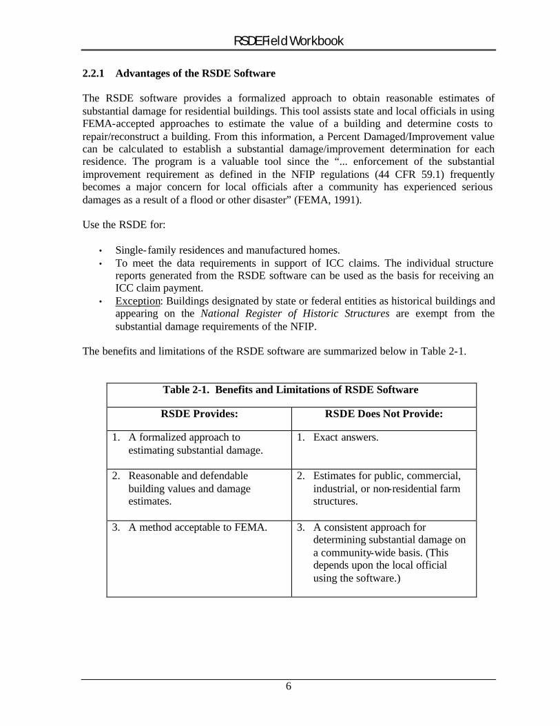
The benefits and limitations of the RSDE software are summarized below in Table 2-1.
Table 2-1. Benefits and Limitations of RSDE Software
RSDE Provides: RSDE Does Not Provide:
1. A formalized approach to estimating substantial damage.
1. Exact answers.
2. Reasonable and defendable building values and damage estimates.
2. Estimates for public, commercial, industrial, or non-residential farm structures.
3. A method acceptable to FEMA. 3. A consistent approach for determining substantial damage on a community-wide basis. (This depends upon the local official using the software.)
6
RSDE Field Workbook
2.2.2 Review of the RSDE Software and Guidance Manual
Obtain a copy of the RSDE software and Guidance Manual and review the requirements for data collection and entry. Key elements to review and understand are:
1. Housing quality. 2. Unit costs appropriate for your area. 3. Those construction components (out of the 16 evaluated for substantial damage) that
will have the largest impact on the determinations.
Housing QualityThere are six housing quality levels to consider during the substantial damage determination process. These are defined in an industry-accepted residential cost-estimating guide as:
1. Low 4. Good
2. Fair 5. Very Good
3. Average 6. Excellent
� NOTE: Without looking at sources of information on housing quality, most residents would guess that they live in either a Very Good or an Excellent quality home. Although possible, this is usually not the case.
"Quality" refers to the quality of the original construction as defined in an industry-accepted residential cost-estimating guide. The quality level only effects the unit costs used indetermining the base cost for a house and has no effect on the percent breakdown. Standard housing involves homes that generally range between the Fair and Good quality level. The best reference for determining housing quality is to refer to the example photographs for various qualities that are contained within a residential cost-estimating guide. Compare these to the structure being evaluated and determine which category, based on the photographs and the accompanying descriptions of the quality of the construction components, fits the home.
Unit CostsUnit costs (i.e., costs per square foot) for estimating the base cost of a house can either be obtained from an industry-accepted residential cost-estimating guide or derived by localofficials. Officials may obtain unit costs from a variety of sources such as listed below, provided that the data are reasonable and appropriate for the area, consistently applied throughout the community, and include true labor and material costs.
� NOTE: Donated or discounted labor and materials must be evaluated at their true costs.
7
RSDE Field Workbook
Some potential sources of cost information are:
1. Industry-accepted residential cost-estimating guides. 2. Residential building permit data. 3. Discussions with local contractors or realtors. 4. Adjusted tax data. 5. Insurance claims data. 6. Professional appraisals. 7. Guidance or data from adjacent communities with similar housing stock. 8. Personal experience with residential cost estimating.
Industry-Accepted Residential Cost-Estimating GuidesResidential cost-estimating guides contain similar information and use similar methods for estimating base costs for the three types of residences within the RSDE software. Their contents include:
1. Instructions on using the publication. 2. Descriptions (including the quality level) of the building components used in the
RSDE software (e.g., Foundation, Roofing etc.) 3. Photographs showing varieties of houses within the six housing qualities. 4. Base cost tables, on a square footage basis, for various housing types and styles 5. Refinement cost tables, on both a square footage and lump sum basis, for items not
specifically contained in the base costs (e.g., fireplaces, ceiling fans, a second hot water tank, etc.).
6. Tables of Current Multipliers for updating base and refinement costs. 7. Tables of Local Multipliers to adjust base and refinement costs on a geographical
basis.
Industry-accepted residential cost-estimating guides generally cost approximately $125 and are updated on either a quarterly or annual basis. These can be purchased from, among other companies, Dodge, Means, or Marsha ll & Swift. The RSDE software can be used with any of these publications or other sources of base cost data. FEMA does not endorse any publisher or data source.
� REMEMBER: Both the Value of Building and Cost of Repairs/Improvements must be determined using reasonable judgment and industry-accepted methodologies that can withstand regulatory, administrative, and judicial review.
2.2.3 Significant Construction Components
Of the 16 construction components that are included in the Damage Inspection Worksheet, five construction components have the most impact on a damage determination. This is important because if these components are not damaged beyond 45%, the structure will not be substantially damaged even if all the other components are 50% damaged. Alternatively,
8
RSDE Field Workbook
if the structure has foundation, superstructure, interior finish, and plumbing damage at 100%, the house is substantially damaged even if all the other components are 0% damaged.
� REMEMBER: Because of their relative weight in the percentage calculation, if the foundation, superstructure, interior finish, plumbing, or exterior finish are not significantly damaged, the structure will most likely not be substantially damaged.
The percent breakdowns for different housing types and styles appear in parentheses:
• Foundation (6.9% or 16.9%)• Superstructure (18.5%, 20.7%, or 20.8%)• Interior finish (plaster/drywall) (8.7%, 9.7%, or 9.8%)• Plumbing (8.0%, 8.9%, or 9.0%)• Exterior finish (6.2% or 6.9%)
9
RSDE Field Workbook
3.0 PRE-DISASTER PLANNING
After a disaster, local officials are faced with an overwhelming amount of critical work needed to help their community get back to normal. Local officials should have a working knowledge of the NFIP requirements for substantially damaged houses and be familiar with the RSDE software (including the data requirements and the use of the Damage Inspection Worksheets); these items are summarized here.
There are several important actions that community officials can perform before a disaster occurs to facilitate substantial damage evaluations after the event. These include:
1. Preparing community policy and action plan (Section 3.1). 2. Identifying available data resources needed to make substantial damage
determinations (Section 3.2). 3. Reviewing and organizing community maps of floodprone or repetitive loss areas
(Section 3.3). 4. Compile and review relevant tax data (Section 3.4). 5. Identifying the residential structure types and qualities within the floodprone areas of
the community (Section 3.5). 6. Entering any available data into the RSDE software before the disaster (Section 3.6).
The suggested actions are described in detail below and will assist the community in completing their substantial damage evaluations faster and more efficiently, thereby helping their residents through faster completion of the determinations.
A checklist of the recommended pre-disaster planning activities discussed below is contained in Appendix A.
3.1 PREPARE COMMUNITY POLICY AND ACTION PLAN
After a disaster, community officials will be handling a multitude of urgent tasks. Any pre-planning that can be accomplished will greatly facilitate response time.
3.1.1 Select RSDE Coordinator
If possible, select an RSDE Coordinator each year. This person should optimally be an official familiar with the community and familiar (or tasked with becoming familiar) with the NFIP, the local floodplain ordinance and the RSDE requirements and software. Ideally this person would also have, or gain, experience performing substantial damage structure inspections. If a single person is not available to take on this responsibility, several individuals could comprise an RSDE Team.
10

RSDE Field Workbook
The RSDE Coordinator responsibilities can include:
1. Being the local NFIP / RSDE expert. The RSDE Coordinator should become familiar with the NFIP regulations, the local floodplain ordinance, the RSDE software, and the reference materials available.
2. Staff training. The RSDE Coordinator should understand the RSDE requirements sufficiently to be able to train office staff and field inspection teams.
3. Organizing a RSDE data collection and data entry program. The RSDE Coordinator can assist the community in making the decisions outlined below in Section 3.1.2 (Community Policy), including:
� Determining what type of RSDE inventory the community wants to keep (i.e., only substantially damaged homes or all homes located in SFHA).
� Deciding whether photographs of each structure are to be taken. � Deciding how staffing will be handled after a disaster. � Determining what kind of filing system would best meet the needs of the
community. � Defining the policy on resident interaction to be used by inspector teams
during field inspections.
4. Planning and implementing the substantial damage field inspections. The RSDE Coordinator can plan and implement the field inspection program after a disaster (refer to Section 4.2, Step A for more detail of RSDE Coordinator responsibilities related to this topic)
5. Ensuring proper follow-up and filing of collected data. The RSDE Coordinator should make sure the RSDE inventory and follow-up is conducted in a proper and thorough manner, is adequately documented, and that the filing system is working well.
The RSDE Coordinator does not necessarily need to be the field coordinator (refer to Section 4.2), although this workbook assumes that they will be the same person. If two people staff the position, the overall coordinator could be responsible for training, NFIP compliance, resident coordination, data entry, and signing of the RSDE reports and determination letters. The field coordinator could be responsible for field preparations, route planning, data collection, data quality and consistency, and completion of all field activities.
3.1.2 Community RSDE Policy
There are many decisions that will need to be made prior to sending inspection teams into the field after a disaster. Many of these decisions can be made in advance and recorded for implementation after a disaster. The following section describes some of the decisions that
11
RSDE Field Workbook
can be made in advance – in certain instances the reader will be referenced to another section in this workbook that presents additional or more complete information on the topic.
Organization of the RSDE InventoryEach community must decide whether they want to keep files on every structure within the SFHA or only those structures that have been damaged to a degree that requires substantial damage inspection (generally, those over 25% damaged, as described in Section 4.2, Step C)
Decide whether Photographs will be takenThe community officials should decide whether to take photographs of damaged structures inspected as part of the RSDE field inspection program. As described in Section 5.4, taking photographs will slow the rate of the inspections and will necessitate additional record keeping.
Determining a Filing System It is recommended that a file be kept for each structure within the SFHA inspected as part of the RSDE field inspection program. A standard list of materials to be added to the file should be identified. Refer to Section 6.5 for more information.
Staffing After a DisasterAfter a disaster, staff will be needed to perform the field inspections (Section 5.1) and staff will be needed to perform the data entry (Section 6.5). Some guidelines for where these staff will be drawn from should be decided upon.
A policy should be decided as to who would enter the data into the RSDE software. It is generally most efficient to use office staff to enter the data into the RSDE software (instead of having the field inspection teams enter their own data), but some communities do not have sufficient staff to do this.
Define Policy on Entry Procedures for Inspecting StructuresDetermine the procedures that substantial damage inspectors will use for entering houses and other structures. These procedures should be decided on in advance of a disaster. In cases of significant damage, many structures will be unoccupied immediately after the event and should therefore be available for inspection. The Letter of Introduction should be left at the home as a record of the visit. For instances of minor damage, the structures may still be occupied or in the case of commercial and industrial structures, the structures may be in use. Most local codes allow health and safety inspections by community representatives.
Inspections should be:
� Performed during normal business hours� By appointment, for structures that are occupied or in use� Based on a reasonable cause – potential health, safety, or substantial damage
concerns
12
RSDE Field Workbook
� Conducted in a professional manner, using as few invasive measures as possib le (i.e., removal of walls, ceilings or flooring to check for damage or health issues, such as mold growth.)
Inspectors should carry identification. As a minimum, inspectors should carry both a Letter of Introduction from the community and a photo identification badge. The Letter of Introduction should be issued on community letterhead and explain the purpose of the inspection and list the name and telephone number of a community contact to further discuss the inspection. A sample Letter of Introduction is included in Appendix B. Communities may want to include a list of permit requirements with the Letter of Introduction.
Alert relevant emergency response departments. Prior to the start of the inspections, the local and county police, fire and emergency services departments should be contacted to inform these agencies of the purpose and proposed dates of the inspections.
Ask permission. If present during the inspection, owners should be asked for permission before the inspectors enter a structure. Inspectors should not enter locked structures or structures where the owner has refused permission. The location of such structures should be reported to the proper community officials for further action.
3.1.3 Develop an Action Plan
A brief post-disaster action plan, listing key activities and responsible parties, can be prepared, reviewed, and finalized ahead of time. This plan does not need to be elaborate and may consist only of a bulleted list of basic activities, in order of their performance, and the names and telephone numbers of community staff that will be responsible for the activities. The contacts and telephone numbers for fire, police, and emergency management at the local, county, and state level should be included in this list. If neighboring counties or communities will be providing assistance, a copy of the mutual aid agreement, specifying the level of effort and responsibilities of all parties, can be included with the action plan.
3.2 IDENTIFY AVAILABLE RESOURCES
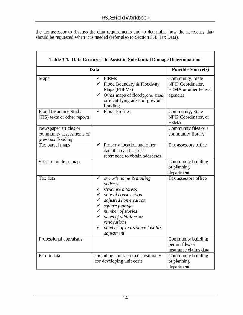
After reviewing the RSDE software and Guidance Manual to understand the data needs (refer to Section 2.2), community officials should identify the local resources necessary to prepare substantial damage determinations and know where to find this data when needed. Possible available resources are shown in Table 3-1.
Some of the data below may not be readily available when it is needed after a disaster. In those cases, determine in advance who has the data and the quickest way to obtain it.
Advance planning can effectively shorten response time after a disaster. For instance, the adjusted tax data may be within a larger database that contains information beyond what is needed for RSDE data entry. In this situation, it will be worthwhile to meet beforehand with
13
RSDE Field Workbook
the tax assessor to discuss the data requirements and to determine how the necessary data should be requested when it is needed (refer also to Section 3.4, Tax Data).
Table 3-1. Data Resources to Assist in Substantial Damage Determinations
Data Possible Source(s)
Maps � FIRMs � Flood Boundary & Floodway
Maps (FBFMs) � Other maps of floodprone areas
or identifying areas of previous flooding
Community, State NFIP Coordinator, FEMA or other federal agencies
Flood Insurance Study (FIS) texts or other reports.
� Flood Profiles Community, State NFIP Coordinator, or FEMA
Newspaper articles or community assessments of previous flooding
Community files or a community library
Tax parcel maps � Property location and other data that can be cross-referenced to obtain addresses
Tax assessors office
Street or address maps Community building or planning department
Tax data � owner's name & mailing address
� structure address � date of construction � adjusted home values � square footage � number of stories � dates of additions or
renovations � number of years since last tax
adjustment
Tax assessors office
Professional appraisals Community building permit files or insurance claims data
Permit data Including contractor cost estimates for developing unit costs
Community building or planning department
14
RSDE Field Workbook
3.3 REVIEW FIRMS AND OTHER COMMUNITY MAPS
Local officials should be familiar with areas of their community that are either floodprone or repetitive loss areas. "Floodprone" refers to all areas within the SFHA on the community's FIRM or other flood inundation maps prepared by federal, state, or local agencies. "Repetitive loss areas" are those areas of the community, either inside or outside of the SFHA that have previously flooded.
It is important to note that flooding can and does occur outside of the SFHAs shown on the community's FIRM. This is due to several reasons. The FIRM may be outdated and not reflect increases in stream flow due to rainfall runoff from new development. There may be structural changes to the channel such as new or replaced bridges, channelization, or flood control projects (levees, floodwalls, detention basins, etc.). Development may have also occurred in areas not previously mapped by FEMA. Lastly, a monumental flood (i.e., >100-year flood) will likely exceed the mapped boundaries of the SFHA.
� REMEMBER: The NFIP requirements for substantial damage determinations only involve the SFHA. Communities are not required to evaluate floodprone or repetitive loss structures located outside the SFHA
Prepare Up-to-Date Community Maps Showing Floodplain and Street DataBecause the primary intent of the FIRM is to show the limits of the 100-year floodplain, street data (i.e., names and locations) may not be current or accurate. Therefore, it is recommended that the 100-year floodplain delineations from the FIRM be carefullytransferred onto another community map with current street or property information. Maps with structure locations (derived from aerial orthophotos), addresses, or tax parcel boundaries are the most useful for verifying structure locations during the field data collection phase. It will also be beneficial to highlight any known areas of past flooding on this map to identify the repetitive loss areas. Carefully and thoroughly prepared community maps will save staff crucial time after a disaster.
3.4 TAX DATA
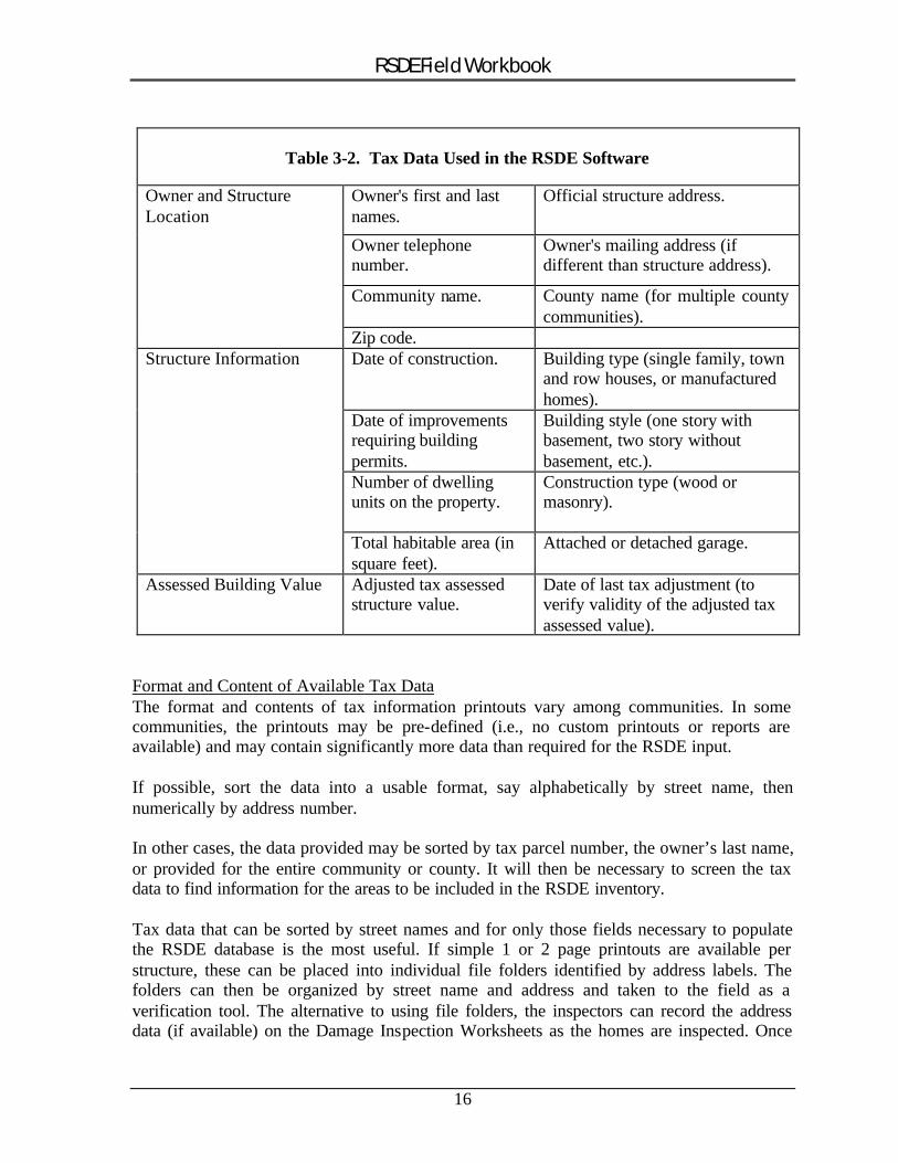
When available, tax information can be useful for providing much of the data required for the Address Information (Tab 1) and the Site, Damage, & FIS Information (Tab 2) sections of the RSDE software (refer also to Section 2.2). A review of any compiled tax data prior to field deployment can save time in the field while increasing the accuracy and consistency of the data collected. When possible, the tax data should be sorted alphabetically by street name and then numerically by address to facilitate field use. The tax data used in the RSDE software is shown in Table 3-2.
Some tax printouts may contain a simple diagram of the structure’s footprint that can be used during the field inspection to verify building size, orientation, and location.
15
RSDE Field Workbook
Table 3-2. Tax Data Used in the RSDE Software
Owner and Structure Location
Owner's first and last names.
Official structure address.
Owner telephone number.
Owner's mailing address (if different than structure address).
Community name. County name (for multiple county communities).
Zip code. Structure Information Date of construction. Building type (single family, town
and row houses, or manufactured homes).
Date of improvements requiring building permits.
Building style (one story with basement, two story without basement, etc.).
Number of dwelling units on the property.
Construction type (wood or masonry).
Total habitable area (in square feet).
Attached or detached garage.
Assessed Building Value Adjusted tax assessed structure value.
Date of last tax adjustment (to verify validity of the adjusted tax assessed value).
Format and Content of Available Tax DataThe format and contents of tax information printouts vary among communities. In some communities, the printouts may be pre-defined (i.e., no custom printouts or reports are available) and may contain significantly more data than required for the RSDE input.
If possible, sort the data into a usable format, say alphabetically by street name, then numerically by address number.
In other cases, the data provided may be sorted by tax parcel number, the owner’s last name, or provided for the entire community or county. It will then be necessary to screen the tax data to find information for the areas to be included in the RSDE inventory.
Tax data that can be sorted by street names and for only those fields necessary to populate the RSDE database is the most useful. If simple 1 or 2 page printouts are available per structure, these can be placed into individual file folders identified by address labels. The folders can then be organized by street name and address and taken to the field as a verification tool. The alternative to using file folders, the inspectors can record the address data (if available) on the Damage Inspection Worksheets as the homes are inspected. Once
16
RSDE Field Workbook
the data entry is complete, the RSDE summary printout and copies of community and resident correspondence can be added to the structure’s folder (Section 6.5).
3.5 REVIEW THE HOUSING STOCK
Using a map with SFHA delineations (FIRM or other community map), walk or drive through the floodplain to identify and record the housing stock for various subdivisions and neighborhoods. Structure type, size, value, and housing quality tend to be similar within a neighborhood. For example, although possible, it is unlikely that an excellent quality house would be adjacent to a low or fair quality house. For a given neighborhood (excluding vacation areas), houses tend to be either in the same quality category or one category above or below each other (i.e., fair and low or fair and average). Similarly, housing types (single family, town and row, and manufactured) tend to be consistent within a subdivision. While house values and sizes may vary due to a mixture of one- and two-story homes, these usually are within given ranges for total square footage, unit costs, and market values.
For known areas of flooding, it is recommended that the community record the general housing quality information. This is a good idea because the severity of the disaster may make it difficult to assess the quality later on. Housing quality can be collected by manually recording the data on RSDE Damage Inspection Worksheets or by either photographing or videotaping the homes of the area on a home-by-home and block-by-block basis. Curbside views, without stepping onto the property or entering the home, are normally sufficient for this data.
3.6 PRE-ENTER AVAILABLE DATE INTO RSDE SOFTWARE
Any available information regarding the structures located within the SFHA can be entered into the RSDE software in the planning phase. Information may include data derived from tax information (refer to Section 3.4), building permits, contractor estimates, or internal inspections of houses. Any data pre-entered into the RSDE will facilitate determinations once a flood or other disaster occurs.
Data can be pre-entered into the data fields on the first three tabs of the RSDE software -Address Information; Site, Damage, and FIS Information; and Base Cost. The Substantial Damage determination cannot be computed until after the disaster occurs and the damages are recorded. Refer to Section 2.2 (or the RSDE Guidance Manual) for more information.
17
RSDE Field Workbook
4.0 AFTER THE DISASTER – WHAT NEXT?
This section addresses actions that can be taken by homeowners after a disaster and actions that should be undertaken by an individual or small group to prepare for the RSDE field inspections. Sections 5.0 and 6.0 address the actual field preparations and RSDE field inspections.
Speed is of the Essence for Substantial Damage Determinations.Local officials should initiate substantial damage determinations as soon as possible after the disaster, but definitely within two weeks. After recovering from the initial shock of the disaster, homeowners will be anxious to begin salvaging and reconstructing their homes. If reconstruction begins without local review and approval, several problems can occur:
• Substantially damaged structures may be reconstructed in violation of the local floodplain ordinance.
• Homeowners may have repaired a structure in violation of other local building code requirements.
• Reconstruction of structures that were less than substantially damaged may involve a mixture of new construction and repairs that combine to equal or exceed the 50% threshold for substantial damage or substantial improvement.
• It may be difficult for local officials to separate repairs or new construction from undamaged portions of the structure.
4.1 HOMEOWNERS CAN BEGIN STRUCTURE CLEAN-UP
Residents and businesses will look to community officials for guidance on the clean-up and reconstruction after a major disaster. While almost all disasters involve debris removal of natural materials like trees and mud, some will also involve removal of manufacturedmaterials. These materials may include construction materials (flooring, drywall, roofing, etc.), vehicles, or personal items like furniture and clothing.
Hazardous MaterialsIt will be necessary to determine whether hazardous (or potentially hazardous) materials are present and if so, what procedures are needed to remove and dispose of these items properly. The local or county environmental planning department or waste management company can supply a list of common household hazardous materials and instructions for proper disposal. A list of possible hazardous materials includes:
• household cleaners • paints • waste oil • gasoline • asbestos • appliances
18
RSDE Field Workbook
Dry the StructureWhen a structure is flooded, the owners should determine whether items such as flooring, interior finishes, or appliances can be salvaged or if these items should be removed for disposal. It is important to remove wet items as soon as possible after floodwaters have receded in order to reduce mold growth and possible “wicking” where initially dry but porous materials continue to absorb moisture. These items may include clothing, furniture, drywall, insulation, and carpeting. Mold growth and wicking will lead to additional damages if not addressed quickly and completely.
After damaged materials are removed, the interior structure surfaces should be cleaned with anti-mold disinfectants and should be aired out (via windows or electric fans) to promote odor removal and drying of interior structural components such as framing, walls, and roof truss systems that have not been damaged.
4.2 FIVE STEPS TO PLANNING THE SUBSTANTIAL DAMAGE INVENTORY
The following five steps need to be taken to plan an effective substantial damage inspection for a community. These steps can be accomplished by a single individual or by a small team. Careful attention to each of these steps will result in an efficient and well-planned field inspection. Each step provides Background information and Action items, as appropriate.
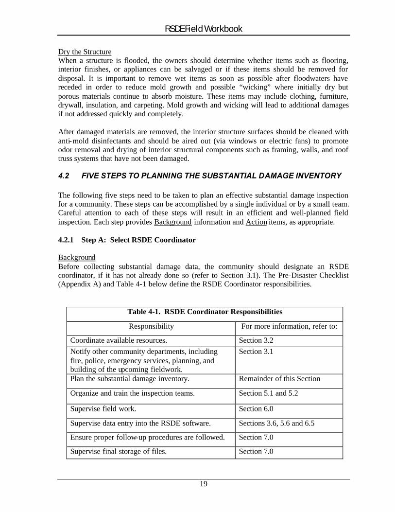
4.2.1 Step A: Select RSDE Coordinator
BackgroundBefore collecting substantial damage data, the community should designate an RSDEcoordinator, if it has not already done so (refer to Section 3.1). The Pre-Disaster Checklist (Appendix A) and Table 4-1 below define the RSDE Coordinator responsibilities.
Table 4-1. RSDE Coordinator Responsibilities
Responsibility For more information, refer to:
Coordinate available resources. Section 3.2 Notify other community departments, including fire, police, emergency services, planning, and building of the upcoming fieldwork.
Section 3.1
Plan the substantial damage inventory. Remainder of this Section
Organize and train the inspection teams. Section 5.1 and 5.2
Supervise field work. Section 6.0
Supervise data entry into the RSDE software. Sections 3.6, 5.6 and 6.5
Ensure proper follow-up procedures are followed. Section 7.0
Supervise final storage of files. Section 7.0
19
RSDE Field Workbook
ActionSelect a coordinator familiar with the community. The coordinator may be a local floodplain management official, the chief building inspector, the head of the permitting department, or a staff member. The RSDE Coordinator should be involved in the following Steps.
4.2.2 Step B: Identify General Limits of Impacted Area(s)
BackgroundIt is important to understand that not all structures damaged during a disaster will require substantial damage evaluations. Structures that lie outside the SFHA or received only limited damage will not require evaluations.
ActionThe general area of damage should be delineated on a community map – one showing tax parcel or property boundaries – on which the SFHA boundaries have been transferred from a FIRM (see Section 3.3). Only those portions of the community located within the SFHA boundaries will be considered for inspection.
4.2.3 Step C: Perform a Curbside Review of Houses to be Included in Inventory
BackgroundThe workload can often be significant for local officials after a disaster. It is important to remember the following facts about the RSDE requirements:
• Only structures located within the SFHA require evaluation for substantial damage.
• A home that is damaged to 55% of its building value is not treated differently than a home that is damaged to 90% of its building value; they are both considered substantially damaged in terms of the RSDE requirements.
• Similarly, a home that is damaged to 45% of its building value is not treated differently than a home damaged to only 10% of its value; neither of these structures is considered substantially damaged.
Based on the above facts, it is recommended that the field inspection be tailored as follows in order to use the community resources most effectively:
• Only damaged structures within the SFHA should be inspected • Only structures that appear to be within the range of 25% to 75% damaged should
have a complete field inspection.
� NOTE: All damaged homes should be included in the inventory for documentation purposes. However, those homes with apparent damages below 25% or above 75% can be documented through a partial, or less detailed inspection. A partial inspection involves data that adequately supports a determination of either substantial or non-
20
RSDE Field Workbook
substantial damage. The documentation for a partial inspection can involve a photograph, RSDE data entry, or both.
Adequate preparation will result in an efficient and effective field inspection process. The data collected in Step C will help define the scope of the field inspection and the amount of time (in days) necessary to complete the RSDE inventory.
ActionThe following information should be gathered fo r the area(s) of the community identified in Step B. Each action item is described in more detail below.
1. Collect Information
� Duration of flooding (if applicable).
2. Perform Curbside Field Screening
� Count the total number of damaged structures. � Estimate the degree of damage to structures, including depth of flooding
above the lowest floor (if applicable). � Refine the boundaries of area(s) needing field inspection.
[1] Collect Information:
The duration of flooding and the depth of flooding above the lowest floor affect the amount of damage. A structure with a flood depth of five feet and duration of a half-day may have less damage than a structure that had only one foot of water for four days. Before performing the curbside field screening, if possible, note the average depth and duration of flood waters in the damaged area(s).
[2] Perform Curbside Field Screening:
� Count Structures: Count the total number of structures that have been damaged. Include only those structures that are damaged 25% or more of their pre-disaster cost, as described below. The structure count need not be exact and can be obtained by driving through the damaged areas.
In order to have complete information after a disaster, local officials may want to include every house within the SFHA in their RSDE inventory, regardless of the extent of damage. For this situation, basic information for the houses with less than 25% damage can be entered in the RSDE software. These houses should generally NOT be field inspected (beyond a curbside inspection to gather the basic data – refer to Section 6.2)
21
RSDE Field Workbook
� Estimate Damage to Structures: As described in the Background above, structures that are less than 25% damaged or are greater than 75% damaged do not require a full field inspection.
To determine the approximate degree of damage, the RSDE Coordinator (or team) will need to walk or drive by the damaged area(s) (using community / FIRM map prepared in Step B). It may be necessary to perform a preliminary evaluation of several sample homes in order to get an idea of the interior flood depth and damage for the area.
Use the following criteria to aid in determining the estimated damage determination:
� To determine 25% or less damage If the interior flood height only reached a level of 1 foot or less above the first floor in a given neighborhood, and the duration was less than one day, it can generally be assumed that the damage to the homes in that neighborhood will be less than 25%. Estimating the flood depth can often be accomplished from curbside examination of neighborhoods. If needed, perform a few preliminary structure inspections and use the RSDE to verify and document the percent damage.
� To determine 75% or more damage If there is obvious exterior damage to the structure, such as a missing roof or wall or a wall with a large hole in it, it can generally be assumed that the structure is substantially damaged and no further inspection need occur.
� For damage to manufactured homes For manufactured homes, interior flood depths of 6 inches or more can result in a total loss of the structure.
� NOTE: The screening range of 25% to 75% for full inspections is only a recommendation. Experienced local officials may feel comfortable using a smaller range of 40% to 60%, for instance. A screening range less than this is not recommended. All homes, with either partial or full inspections, should be included in the inventory.
� Refine Delineation of Field Inspection Area(s): Based on the curbside screening described above, delineate the area(s) to be included in the field inspection using the map prepared in Step B. The area over which the damaged structures are spread will affect the time spent collecting the field data. For example, it may require more time to inventory 25 structures spread among three subdivisions than it will to inspect 50 structures in a single area.
If local officials want to include all damaged structures in the field inspection, then the field inspection map should differentiate those areas with structures damaged 25% or more in order allow the most time for the inspection of these structures.
22
RSDE Field Workbook
� REMEMBER: Effectively identifying and performing full inspections for only those structures damaged between 25% and 75% of the building value will save the community a significant amount of time and money.
4.2.4 Step D: Define the Scope of the Inventory
BackgroundAfter performing the initial screening, as described in Step C, the scope (size and duration in days) of the inventory can be determined.
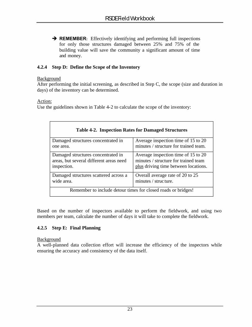
Action:Use the guidelines shown in Table 4-2 to calculate the scope of the inventory:
Table 4-2. Inspection Rates for Damaged Structures
Damaged structures concentrated in one area.
Average inspection time of 15 to 20 minutes / structure for trained team.
Damaged structures concentrated in areas, but several different areas need inspection.
Average inspection time of 15 to 20 minutes / structure for trained team plus driving time between locations.
Damaged structures scattered across a wide area.
Overall average rate of 20 to 25 minutes / struc ture.
Remember to include detour times for closed roads or bridges!
Based on the number of inspectors available to perform the fieldwork, and using two members per team, calculate the number of days it will take to complete the fieldwork.
4.2.5 Step E: Final Planning
BackgroundA well-planned data collection effort will increase the efficiency of the inspectors while ensuring the accuracy and consistency of the data itself.
23
RSDE Field Workbook
ActionUsing all the information gathered, the RSDE Coordinator should perform the following tasks:
Task 1. Subdivide the identified damage areas into team areas and plan the approximate sequence of inspections using the best available community map with the transferred SFHA boundaries. The route and team assignments can be assigned on a block-by-block, neighborhood, or subdivision basis. When laying out a data collection route, it is important to ensure that:
� Assignments include all areas within the SFHA with potential substantial damage (those structures identified as having damage of 25% or greater - refer to Section 4.2.3).
� There are no gaps in data collection (particularly at the end of a block where houses face a cross street).
� There are no overlaps in data collection (different inspection teams inspect the same house).
The route is determined in a logical sequence to reduce travel time and facilitate data collection and entry.
Task 2. Prepare guidance and any training materials (including an adequate supply of Damage Inspection Worksheets) for the inspectors. Training should include the following:
� Group pilot inspections for up to three homes to familiarize the inspectors with RSDE Damage Inspection Worksheets and the required data.
� Full inspection efforts should be focused on homes with damages between 25% and 75%.
� Inspections should take a maximum of 20 minutes each after the first two days. � Guidance for resident interaction (Appendix B). � Use copies of Tables 6-1 and 6-2 as guidance for completing the exterior and interior
inspections.
Task 3. Identify resources (flood maps, street maps, tax data, etc.) that will be needed and, if possible, begin assembling. Ideally, the RSDE Coordinator will already have this data collected, as described in Sections 3.2 through 3.5.
Final Field PlanThe RSDE Coordinator should have a final field plan containing the following elements:
• Number and location of houses to be inspected • Delineation of areas to be inspected • Sequence of inspections • Guidance materials for inspectors • Identify whether photos will be required
24
RSDE Field Workbook
5.0 FIELD PREPARATIONS
Before assembling inspection teams and performing field training, the scope of the inventory should already have been defined as described in Section 4.2. Before beginning ANY field inspections, notify the local fire, police, and emergency management agencies of the purpose and proposed dates of inspections. It is also recommended that the community issue a press release providing the reasons for the inspections, the inspection process, hours of operation, and a community contact. The RSDE Coordinator should either do these tasks or ensure that they have been completed.
5.1 INSPECTION TEAMS
It is recommended that individual inspection teams consist of two individuals for the following three reasons:
1. Two people will be needed if structure dimensions are to be field-verified using a 100-foot tape measure.
2. Two-member teams are also useful for ensuring that information for all 16-construction components required for an RSDE determination has been evaluated and recorded on the Damage Inspection Worksheets.
3. Lastly, it is better to have two staff evaluate the “percent damaged” for each of the 16 construction components since each person evaluating damage will tend to look at things from a slightly different perspective based on their past experience. An estimate of the percent damaged based on a team consensus will be more reasonable and defendable than an estimate from a single person.
For multiple teams, designations should be assigned by number (1, 2, 3, etc.), alpha character (A, B, C, etc.), or color (Red, Green, Blue, etc.). The team designation will help to distinguish between the field supplies, photographs (if required), and data collection areas (checked off on a map).
Materials and Field EquipmentEach team should be provided with the following items:
• Guidance materials and handouts prepared by the RSDE Coordinator. • Copy of FIRM / community map with inspection areas identified. • Any collected tax information that can be included on the RSDE Damage
Inspection Worksheets. • Each team should be given a copy of the Checklist #2 (field supplies and
procedures) located in Appendix A. Team members should be responsible for gathering and maintaining the required field supplies.
25
RSDE Field Workbook
5.2 PILOT RSDE INSPECTIONS
In preparation for the inspections, the RSDE Coordinator should take all the inspectors to the field and conduct from one to three pilot inspections of houses with various levels of damage. These houses can be the first entries in the RSDE inventory. The purpose of the pilot inspections is to familiarize the inspectors with the inspection procedures and the data required for completing the Damage Inspection Worksheets. For those with limited home inspection experience, the inspections will provide a first-hand view of the 16 components listed on the Worksheet. Through on-site discussions, the inspection teams will also get a feel for how to estimate the percent damage for each component. In addition, the inspection teams will learn how to evaluate damage on a consistent basis. Each pilot inspection will require between 45 to 90 minutes.
5.2.1 Field Training
During the Pilot Inspections, the RSDE Coordinator should be sure to include the following:
Guidelines for estimating damage to 16 structural components Refer to Sections 6.3 and 6.4, and Tables 6-1 and 6-2
Guidelines for how long each house should take Refer to Section 4.2.4. Stress importance of taking the most time and attention to those houses in the 25% - 75% damage range (see below).
Review the guidelines for significant construction components (Section 2.2.3)
It is important to remind inspectors that houses that are either clearly NOT substantially damaged and houses that ARE clearly substantially damaged need not be inventoried unless the community wants the basic information for each house in the SFHA included in their RSDE inventory.
Accuracy issue Those houses with damages in the 25% to 75% range will require the most accuracy since a mistake here may incorrectly put the house above or below the 50% damage threshold. It is recommended that officials consider a second or independent evaluation for structures where the initial determination is between 45% and 55% damaged. Appeals of substantial damage determinations tend to occur more frequently for homes in this range than any others.
5.3 ADDRESSES
Inspectors should be aware that not every house will have an address posted on the structure or mailbox. Although this is more common in rural areas, it can also occur in urban areas. The lack of address may be due to the age of a structure, local custom, lack of a 9-1-1 emergency call system, or the lack of a local requirement for posting addresses. In these
26
RSDE Field Workbook
situations, it will be necessary to use either a community address map or tax parcel number map to identify and distinguish specific structures in the inventory.
If Needed, Use Tax Parcel Identification NumbersSometimes it is necessary to cross reference tax data that contains an official address with a map containing tax parcel identification numbers. This process can be confusing and time consuming. Therefore, it is recommended that the address numbers be transferred to the field copy of the tax map prior to field deployment. This will save the effort of constantly referring to the tax printouts for the addresses.
Use Addresses Whenever PossibleAddresses are important because it is the simplest and most common method for identifying and distinguishing a structure. While unique, tax parcel numbers can involve many digits and be difficult for manual tracking or sorting of the data. As the volume of data collected increases, it may become easy for inspectors and data entry staff to become confused regarding specific structures or data. The use of addresses is a familiar and easy way to sort structures and track data.
Note Address For All Recorded Data ItemsDue to its importance, addresses should be used for all recorded data items associated with the inventory. This includes the Damage Inspection Worksheet, photographs (if used) and photo logs, and the RSDE data entry.
If Photos Are Taken, Use An “Address Board”One method to verify the structure location is to include an “address board” in thephotograph of the structure. To do this, one of the inspectors holds a hand-written address (number and street name) on a dry-erase board (or on an 8-1/2- inch by 11-inch paper tablet) in a lower corner of the photograph. Using a dry-erase board can save time by writing the street name at the beginning of a street and then just changing the address number for each successive house. Whichever method is used (paper or dry-erase board), a black marker should be used on a white background to ensure that the data stands out against the house in the photograph.
Be sure that:
� the address number is large enough to be visible in the printed photograph � the “address board” does not block out too much of the background to make the
house indistinguishable from other houses on the block
5.4 PHOTOGRAPHS
Decide Whether to Use PhotographsPrior to deploying the inspection teams, it should be decided if photographs will be obtained for each structure included in the inventory. Obtaining and recording photographs will require additional time and therefore slow the rate of inspections. Additionally, the RSDE
27
RSDE Field Workbook
Version 2.0 software does not have provisions for including photographs with the substantial damage data. Therefore, the photographs will need to be collected and stored separately from the other data requiring additional time for processing and cataloging the printed photographs.
If photographs are required, decide:
� quantity (number per structure)� format (standard 35 mm film, disposable camera with 35 mm film, instant, or digital)� type (curbside view vs. close-ups of damage)
When photographs are required, it is recommended that only one photograph, from acurbside view of the front or side of the structure, be obtained. Multiple photographs for each structure can be very time consuming to obtain, record, and process.
Recording the Photographs in the FieldAs the photographs are taken in the field, they should be recorded on a photo log to ensure that the inspectors are able to match an individual photograph to a specific structure. A sample photo log is included in Appendix A. A new photo log should be started for each day, roll, or disk. At a minimum, a photo log should include the following data:
1. Team designation. 2. Date. 3. Community name (only if multiple communities are involved). 4. Roll or diskette of film. 5. Photo number. 6. Address or location.
Processing and Storing PhotographsFor guidelines on processing and storing the photographs, refer to Section 6.5.2.
5.5 RESIDENT INTERACTION
Contact between inspectors and residents will be almost impossible to avoid while the data collection occurs. Residents will naturally be curious or even suspicious of the objectives of the inspections. Therefore, the RSDE field coordinator should set guidelines for any interactions with residents. A list of Recommended Guidelines for Contact with Residents is contained in Appendix B.
• When an inspector encounters a locked house or is refused entry by a homeowner, he or she should record the address, a telephone number for the owner (if available), the problem encountered and move on to the next inspection.
• Lengthy conversations with residents should be avoided since these will slow the inspection rate and quickly become repetitive. Instead, the inspectors should provide
28
RSDE Field Workbook
a brief, pre-determined response stating that the post-disaster inspections are required by the community’s ordinance.
• Comments or additional questions should be directed to the point of contact identified in the Letter of Introduction discussed in Section 3.1.2 and Appendix B.
• Under no circumstances should an inspector discuss the potential impact of substantial damage determinations, various types of disaster aid, or a potential buyout program. However, the inspectors can and should explain local permit requirements for rebuilding, particularly if repairs are underway.
5.6 PREPARING FOR DATA ENTRY INTO RSDE SOFTWARE
Decide Who Will Enter Data Into RSDE SoftwareIf possib le, office support should enter data into the RSDE software (though field inspectors can do this if staff is unavailable). When multiple inspection teams are used, the data entry staff will be able to maintain data consistency and can flag incomplete or questionable data for further explanation or review by the inspectors.
Field data entry into a portable computer is strongly discouraged. In addition to slowing the inspection rate, it distracts the inspectors and can lead to inconsistent data entries. There is also a significant risk of damaging a computer used in the field.
Decide When Data Will Be EnteredData entry can be completed at the end of each day, the day following the data collection, or after all data has been collected. The recommended procedure for data entry is for support staff to enter the data the day following the data collection. This will allow the inspectors to proceed without interruptions and therefore finish their inspections faster.
To Maximize EfficiencyTo speed up the data entry process, the RSDE data can be entered into two or more computers simultaneously and then merged into a single community file after the data collection process. This procedure is discussed in the Import/Export section of the RSDE Guidance Manual.
A data entry person with even moderate typing skills should be able to keep pace with up to three inspection teams on a day after basis. Until all houses are entered into the RSDE software, the Damage Inspection Worksheets should be grouped together by team and date and retained to facilitate questions or editing.
Decide Data FormatFor large inventories (in excess of 30 structures) and when multiple inspection teams are used, it is necessary to set guidelines for data formats. The following types of information will needed to be standardized:
29

RSDE Field Workbook
• Will the word "Street" be included in the Address Street field and if so, will it be used as "Street,” "St.," or "St"?
• For small communities, with either one or a limited number of zip codes, will this data be recorded in the field or entered by the data entry staff?
• Will flood durations be entered in hours or days and will flood depths above the lowest floor be entered in inches or feet?
30
RSDE Field Workbook
6.0 RSDE FIELD INSPECTION AND DATA COLLECTION
After reviewing the RSDE data requirements (Section 2.2) and preparing an inspection plan and finishing the pilot inspections (Section 5.2), the RSDE data collection effort is ready to begin.
Using the community street map with the SFHA boundaries and the planned route for data collection, the teams can start their inspections and manual recording of the data. A designated inspection sequence (exterior inspection followed by an interior inspection) will minimize data errors and omissions.
It is important for the RSDE Coordinator to know the general location of the inspectors on a daily basis in case he or she needs to meet them in the field or if a homeowner calls to complain. At the end of the day, the inspectors can either highlight or check off streets or areas where data collection has been completed.
6.1 RATE OF INSPECTIONS
Although the first inspections may take between 30 and 60 minutes, the teams will increase their rate as they become more familiar with the data collection procedures. Also, neighborhoods and subdivisions tend to have similar housing stock (type and quality, see Section 3.5). The familiarity with the houses will facilitate data collection. Flat areas damaged by flooding will generally have similar flood depths and may have similar types of damage.
Once the inventory is underway, inspection teams should be taking between 15 and 20 minutes per house (exclusive of travel time) to evaluate and record data. If, after the first three days, a team is taking longer than 20 minutes per house, the RSDE Coordinator should accompany the team in the field. The Coordinator can verify that the team is following the inspection procedures correctly and applying the proper level of detail to their evaluations, and can assist the team in increasing their efficiency.
6.2 RECORD GENERAL DATA
After arriving at a house, the inspectors should take and log a photograph (if required) and then record the basic data for the home on the Damage Inspection Worksheets. The basic data is standard for every home. Refer to Items #1 through #20 on the RSDE Damage Inspection Worksheets (Appendix A).
Curbside InformationItems #3, #6, #7, #10, #11, #12A, #12B, #12C, #12E(1) - #12E(4), #12F, #12L, and #13 to #16 can be completed at the curbside using visual observation and maps distributed to field teams. If available, Items #1, #5, #8, and #9 can also be completed curbside.
31
RSDE Field Workbook
Exterior InspectionsA more detailed description of how measure the building dimensions (Item #12D) and what to look for during the exterior inspection is included in Section 6.3 and Table 6-1. Items #12D, #12K, #12N, 17A, and parts of #18 to #20 will be completed during the exterior inspection.
Interior InspectionA more detailed description of what to look for during the interior inspection is included in Section 6.4 and Table 6-2. Items # 12E(5), #12G, #12H, #12I, #12J, 12M, 17B, parts of #18, #19 and #20 will completed during the interior inspection.
6.3 EXTERIOR INSPECTIONS
After recording the basic data, the inspectors can estimate the structure area and perform an exterior inspection by walking around the entire outside of the structure.
6.3.1 Measuring Building Dimensions
Before beginning the inspection, measure the building dimensions using a 100-ft tape (see item #12(D) on Damage Inspection Worksheet). Exact dimensions are not required and whenever possible, house shapes should be considered as a rectangle. Small changes in shape, such as bay windows, extended entrances, or fireplace pads, can be ignored.
For houses that do not conform to a single rectangular shape such as an "L" or "U" shape, measure the house as a group of rectangles and sum the results. Because the RSDE software contains data fields for only one set of dimensions, calculate the total square footage outside the software and then enter length and width dimensions that yield an equivalent total square footage.
When recording building dimensions, it may not be necessary to measure each side of a house. Inspectors that feel comfortable with the approach can eyeball the general building length and width dimensions.
6.3.2 Exterior Damage to Look For
Table 6-1 presents the damage items to look for while completing the exterior inspection and can be photocopied for use by the inspectors.
The inspection team should evaluate the 6 exterior construction components from the RSDE percent breakdown section (Item #18 on the Damage Inspection Worksheet). The percent damage estimate should be based a visual inspection of each component. When more than one inspector present, a consensus percent breakdown should be mutually agreed upon by the team.
32
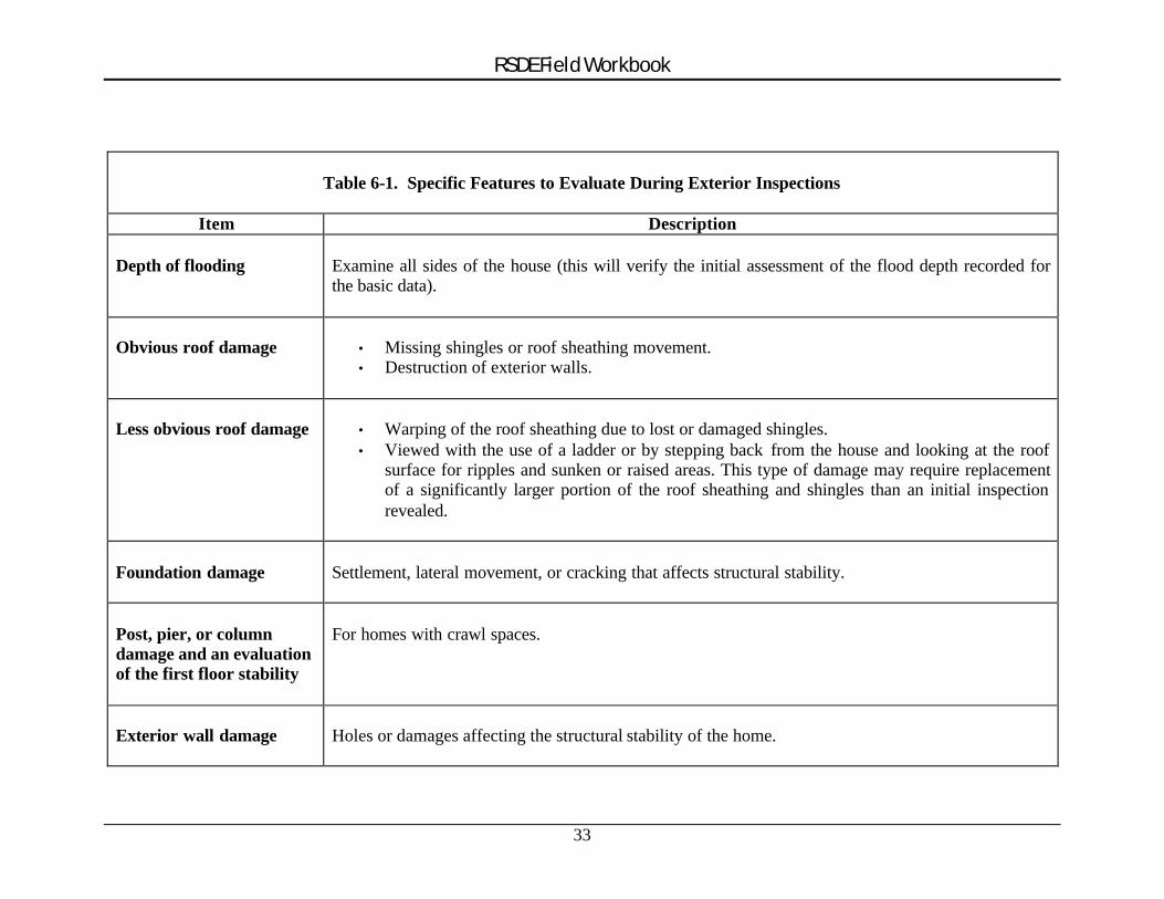
RSDE Field Workbook
Table 6-1. Specific Features to Evaluate During Exterior Inspections
Item Description
Depth of flooding Examine all sides of the house (this will verify the initial assessment of the flood depth recorded for the basic data).
Obvious roof damage • Missing shingles or roof sheathing movement. • Destruction of exterior walls.
Less obvious roof damage • Warping of the roof sheathing due to lost or damaged shingles. • Viewed with the use of a ladder or by stepping back from the house and looking at the roof
surface for ripples and sunken or raised areas. This type of damage may require replacement of a significantly larger portion of the roof sheathing and shingles than an initial inspection revealed.
Foundation damage Settlement, lateral movement, or cracking that affects structural stability.
Post, pier, or column damage and an evaluation of the first floor stability
For homes with crawl spaces.
Exterior wall damage Holes or damages affecting the structural stability of the home.
33
RSDE Field Workbook
One of the keys for determining substantial damage and separating damage from poor maintenance (i.e., peeling paint, rotted eaves) is to consider the repairs necessary to get the house up to local building code requirements and to make it marketable. Therefore, while old paint may affect the selling price, it will not be the deciding factor in whether or not the house sells.
� REMEMBER: Because of their relative weight in the percentage calculation, if the foundation, superstructure, interior finish, plumbing, or exterior finish are not significantly damaged, the structure will most likely not be substantially damaged.
� REMEMBER: Homes that are within the 45% - 55% damage range should be more carefully inspected than those that are clearly either less or more damaged.
6.4 INTERIOR INSPECTIONS
It is important that inspectors remember at ALL TIMES that they are inside someone else’s home. Appropriate care and respect should be demonstrated during the inspections.
Verify StabilityDue to possible structural deficiencies, extreme caution should be exercised when entering damaged buildings. The inspectors must first verify that the floor of the house is stable enough to support their combined weight. Foundation settlement, high flood depths, and damage to floor joists can significantly weaken a floor. For homes built on crawl spaces, this can be checked during the exterior inspection phase.
Use Set Inspection RoutineIt is recommended that a set procedure also be used for the interior inspection to avoid missing any rooms or damages. Inspectors may want to start on the first floor with either the utility rooms (hot water tank, washer or dryer, furnace) or the kitchen and then work their way through the structure on a room-by-room basis.
6.4.1 General Inspection Guidelines
Not all components that get wet are 100% damaged. As an example, drywall and insulation in a house that was flooded for short duration to a depth of two feet above the first floor will only need the area removed below a height of three feet or so (flood depth plus wicking). Similarly, unless broken or permanently contaminated, plumbing pipes and fixtures can be flushed out with disinfectant, cleaned on the outside, and used again. Depending on the depth of flooding, some built- in appliances may only require minor repairs.
34
RSDE Field Workbook
An important aspect of inspecting a structure is determining the damage to its support framework. If possible, the studs and foundation should be inspected for damage. Invasive procedures, such as tearing back wallpaper or drywall, should be kept to a minimum. Inspectors should try to locate areas that are already exposed.
� NOTE: For short duration floods, the interior depth of flooding above the first floor (and therefore, the damages) may be less than the exterior flood depth.
6.4.2 Upgrades or Custom-Designed Items
Any significant upgrades in flooring, interior finishes, kitchen cabinets and countertops, appliances, or custom-designed interiors should be noted on the Damage Inspection Worksheets and evaluated under the Refinements section of the software.
6.4.3 Interior Damage to Look For
The inspection team can evaluate the 13 interior construction components from the RSDE percent breakdown section (Item #18 of the Damage Inspection Worksheet,). The estimate of the percent damage should be based a visual inspection of each component. When more than one inspector present, a consensus percent breakdown should be mutually agreed upon by the team.
Table 6-2 summarizes the type of interior damage to look for, and how to evaluate it, for the 13 interior construction components.
6.5 COMPLETING RSDE DATA ENTRY
After the Damage Inspection Worksheets are completed, either the RSDE software or the RSDE Manual Computation Worksheets can be used to determine substantial damage. Descriptions and clarifications of terms used in the Damage Inspection Worksheets, the Manual Computation Worksheet, and the software can be found in FEMA 311 and industry-accepted residential cost-estimating guides.
� REMEMBER: Refer to the RSDE Guidance Manual and the RSDE Video for assistance in completing the data entry.
RSDE ReportAfter the data has been entered and the methods for determining structure value (computed actual cash value, adjusted tax assessed value, or professional appraisal) and the cost of repairs (computed damages, contractor estimate, or community estimate) have been selected, a summary report for the structure can be printed. Users can choose to print either a one-page summary or a four-page detailed report for each individual structure. The RSDE Coordinator should review the printed copy and then sign and date the last page. This printout is often the official determination for the house, and should be kept on file for future use.
35
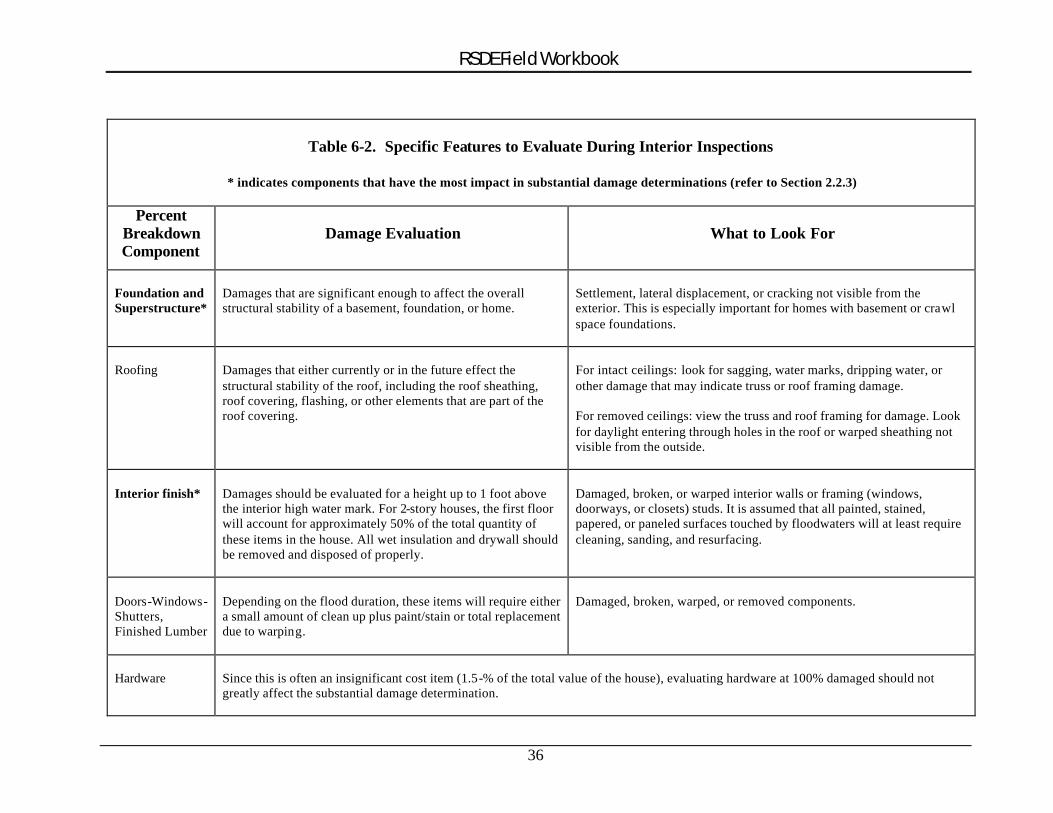
RSDE Field Workbook
Table 6-2. Specific Features to Evaluate During Interior Inspections
* indicates components that have the most impact in substantial damage determinations (refer to Section 2.2.3)
Percent Breakdown Component
Damage Evaluation What to Look For
Foundation and Superstructure*
Damages that are significant enough to affect the overall structural stability of a basement, foundation, or home.
Settlement, lateral displacement, or cracking not visible from the exterior. This is especially important for homes with basement or cra wl space foundations.
Roofing Damages that either currently or in the future effect the structural stability of the roof, including the roof sheathing, roof covering, flashing, or other elements that are part of the roof covering.
For intact ceilings: look for sagging, water marks, dripping water, or other damage that may indicate truss or roof framing damage.
For removed ceilings: view the truss and roof framing for damage. Look for daylight entering through holes in the roof or warped sheathing not visible from the outside.
Interior finish* Damages should be evaluated for a height up to 1 foot above the interior high water mark. For 2-story houses, the first floor will account for approximately 50% of the total quantity of these items in the house. All wet insulation and drywall should be removed and disposed of properly.
Damaged, broken, or warped interior walls or framing (windows, doorways, or closets) studs. It is assumed that all painted, stained, papered, or paneled surfaces touched by floodwaters will at least require cleaning, sanding, and resurfacing.
Doors-Windows -Shutters, Finished Lumber
Depending on the flood duration, these items will require either a small amount of clean up plus paint/stain or total replacement due to warpin g.
Damaged, broken, warped, or removed components.
Hardware Since this is often an insignificant cost item (1.5 -% of the total value of the house), evaluating hardware at 100% damaged should not greatly affect the substantial damage determination.
36
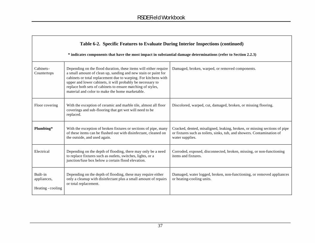
RSDE Field Workbook
Table 6-2. Specific Features to Evaluate During Interior Inspections (continued)
* indicates components that have the most impact in substantial damage determinations (refer to Section 2.2.3)
Cabinets-Countertops
Depending on the flood duration, these items will either require a small amount of clean up, sanding and new stain or paint for cabinets or total replacement due to warping. For kitchens with upper and lower cabinets, it will probably be necessary to replace both sets of cabinets to ensure matching of styles, material and color to make the home marketable.
Damaged, broken, warped, or removed components.
Floor covering With the exception of ceramic and marble tile, almost all floor coverings and sub -flooring that get wet will need to be replaced.
Discolored, warped, cut, damaged, broken, or missing flooring.
Plumbing* With the exception of broken fixtures or sections of pipe, many of these items can be flushed out with disinfectant, cleaned on the outside, and used again.
Cracked, dented, misaligned, leaking, broken, or missing sections of pipe or fixtures such as toilets, sinks, tub, and showers. Contamination of water supplies.
Electrical Depending on the depth of flooding, there may only be a need to replace fixtures such as outlets, switches, lights, or a junction/fuse box below a certain flood elevation.
Corroded, exposed, disconnected, broken, missing, or non-functioning items and fixtures.
Built-in appliances,
Heating - cooling
Depending on the depth of flooding, these may require either only a cleanup with disinfectant plus a small amount of repairs or total replacement.
Damaged, water logged, broken, non-functioning, or removed appliances or heating-cooling units.
37
RSDE Field Workbook
6.5.1 File Folders for RSDE Inventory Data
If file folders are used, the contents for each structure inventoried should include the following:
1. A signed and dated copy of the RSDE individual structure report (1-page summary or 4-page detailed report).
2. Photographs including captions with address or location, date, team name, and film roll (or disk) and photo number.
3. Tax data used to determine the location, address, habitable square footage, or structure value.
4. Letter of Determination. 5. Submittals and correspondence from homeowners. 6. Insurance claims data (if available). 7. Professional appraisal (if available). 8. Contractor's estimate of repairs (if available). 9. Community's estimate of repairs (if available).
The contents of the file folder will be used to support determinations appealed by residents or that become involved in a formal judicial review.
General File Folder.In addition, a general file folder for the disaster can be prepared to include the following:
1. Community Floodplain Ordinance. 2. Sections of the applicable building code relevant to substantial damage. 3. Newspaper articles. 4. Community press releases. 5. Post-disaster photographs. 6. Rainfall and stream gage data. 7. Official estimates of the flood frequency. 8. Copy of the Letter of Introduction used during the inspections. 9. List or inventory of damaged structures. 10. Community assessments of the disaster. 11. Maps showing flooded and inventoried areas.
6.5.2 Processing and Storing Photographs
If data for individual structures are stored in file folders, printed photographs can be added to the folder. Pertine nt information should be included on each photograph as described below.
Analog (35 mm or Instant) Prints
� Write on back: team name, date, roll and photo number, and location � Indicate the high water mark from flooding, if visible, using a pen or highlighter
38
RSDE Field Workbook
Digital Photographs
� Use word processing software to insert the digital photograph (as a picture or object) onto a page that includes a caption with basic information (team name, date, disk and photo number, and location). The advantage in using word processing software is that a standard caption can be prepared with only the photo number and location needing revision between photographs.
� Indicate the high water mark from flooding, if visible, using a pen or highlighter. � A sample of a digital photograph and a caption from an RSDE inventory are
included in Appendix B.
39
RSDE Field Workbook
7.0 POST-DETERMINATION ACTIVITIES
After all the data is collected, recorded, and finalized, the community must initiate follow-up activities to distribute and enforce the results of the substantial damage determinations. The community should consider the following activities:
1. Finalize and store the RSDE data.
2. Inform other community officials about the determinations and the NFIP requirements for reconstructing substantially damaged homes.
3. Prepare a press release to explain the determination process and the implications of the determinations.
4. Prepare and distribute a “substantial damage determination letter” with the name and telephone number of a community contact (sample determination letters are presented in Appendix B). The letter should indicate that the determination was required under the community's floodplain management ordinance and should specify that all rebuilding or new construction will require a community permit.
5. Post notices of either substantial damage or unsafe conditions on homes.
6. Identify publications from FEMA, the Red Cross, and state or local agencies that provide guidance on rebuilding after a disaster.
7. Identify potential mitigation measures for both the community and individual residents.
8. Identify and activate appeal procedures.
9. Notify the State NFIP Coordinator's office of the results of the substantial damage determinations and determine what, if any, additional activities are required.
� NOTE: At a minimum, the community should perform activities 1, 2, 4, and 5 above.
7.1 SUBSTANTIAL DAMAGE DETERMINATION LETTERS
The substantial damage determination letters should involve a consistent format and be mailed to all residents within the inventory, including those without substantial damage. Sample letters for both substantial damage (SD) and no substantial damage (NSD) determinations are provided in Appendix B. These samples are provided as guidance and their use is encouraged but not required.
The mailings should occur after all data is collected and the individual determinations have been signed and dated by the community official. The community should determine enforcement procedures for handling letters that return unopened. It may be necessary to visit these homes to verify that reconstruction has not started without the proper permits.
40
RSDE Field Workbook
Non-Substantially Damaged StructuresFor homes that are not substantially damaged, the owners should be notified that building permits will be required for rebuilding activities. The community should include a copy of the necessary permits and a list of permit fees as well as the appropriate communitydepartment to contact for questions.
Substantially Damaged StructuresIf a home is substantially damaged, the letter should state this and the community should offer a meeting to explain the options for rebuilding.
7.2 REVISING RSDE DETERMINATIONS BASED ON HOMEOWNER DATA
Upon receipt of the notification letter, some homeowners may submit additional or more detailed information than was used by the community during the determination process. The community must evaluate this data and determine if it is appropriate to revise the data in the existing determination. If the determination changes as a result of the new data, the enforcement of the substantial damage requirements will be based on the new determination. While all homeowners should be allowed the option to submit new data and request a revised determination, the community is not required to revise all determinations based on the results of one re-evaluation. Nor is the community required to pay for professional appraisals for all homeowners if an existing determination is reversed based on a homeowner-paid appraisal.
41