Embed Size (px)
DESCRIPTION
Hazard Risk Management in Europe and Central Asia Workshop Agenda June 28-30, 2004 Istanbul, Turkey. Natural Disasters Risk Assessment and Management in Russia Original presentation is modified for Internet use. Russian Academy of Sciences Institute of Environmental Geosciences - PowerPoint PPT Presentation
Citation preview
Hazard Risk Management in Europe and Central Asia
Workshop Agenda June 28-30 2004Istanbul Turkey
Russian Academy of Sciences
Institute of Environmental Geosciences
Dr Alexei L Ragozin
Deputy Director on Science
Natural Disasters Risk Assessment and Management
in Russia
Original presentation is modified for Internet use
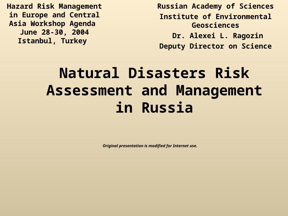
NATURAL HAZARDS ANALYSIS - GENERAL FLOW CHART
Hazard identification
Hazard forecasting
Risk management
Risk assessment
Vulnerability assessment
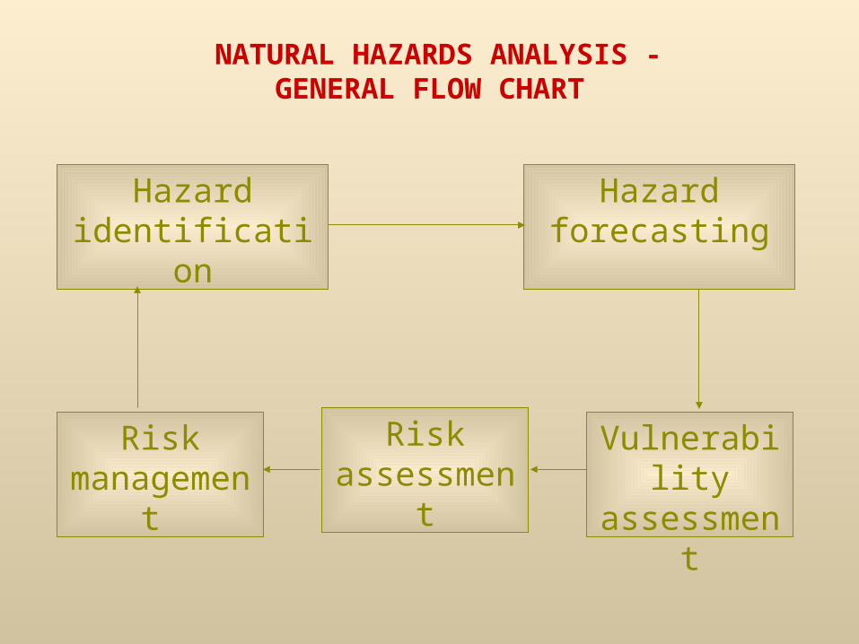
IDENTIFICATION OF NATURAL
HAZARDS
bull What kinds of natural hazards ndash in terms of their genesis development mechanism and intensity ndash have affected the area under assessment where and when
bull Which natural or technogenic conditions and trigger factors have brought about or intensified those hazards
bull What is annual probability (frequency) and intensity of different genetic types and forms of natural hazards in certain parts of the area under assessment (volume velocity affected area duration and other measures of destructive capacity of respective hazards)
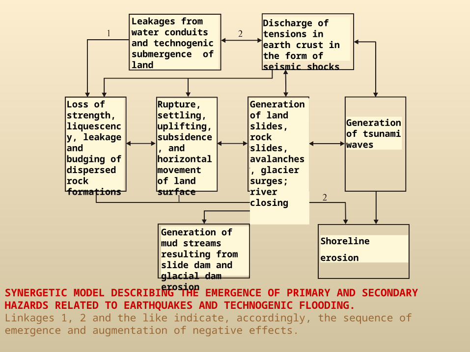
SYNERGETIC MODEL DESCRIBING THE EMERGENCE OF PRIMARY AND SECONDARY HAZARDS RELATED TO EARTHQUAKES AND TECHNOGENIC FLOODING Linkages 1 2 and the like indicate accordingly the sequence of emergence and augmentation of negative effects
Generation of tsunami waves
Shoreline
erosion
Generation of mud streams resulting from slide dam and glacial dam erosion
Generation of land slides rock slides avalanches glacier surges river closing
Discharge of tensions in earth crust in the form of seismic shocks
Loss of strength liquescency leakage and budging of dispersed rock formations
Rupture settling uplifting subsidence and horizontal movement of land surface
Leakages from water conduits and technogenic submergence of land
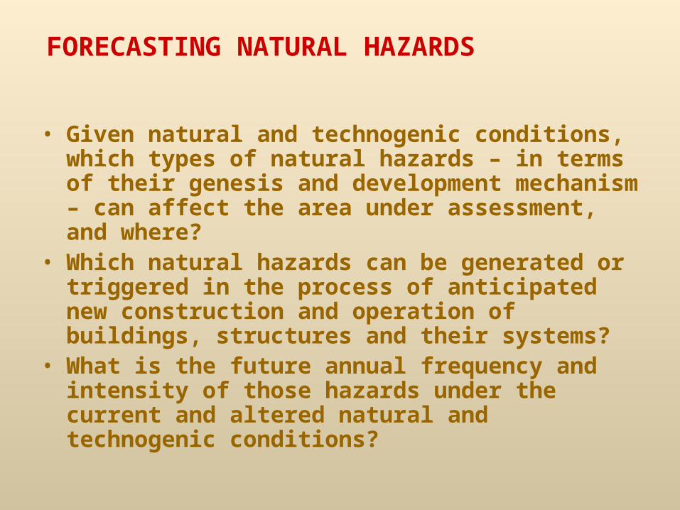
FORECASTING NATURAL HAZARDS
bull Given natural and technogenic conditions which types of natural hazards ndash in terms of their genesis and development mechanism ndash can affect the area under assessment and where
bull Which natural hazards can be generated or triggered in the process of anticipated new construction and operation of buildings structures and their systems
bull What is the future annual frequency and intensity of those hazards under the current and altered natural and technogenic conditions
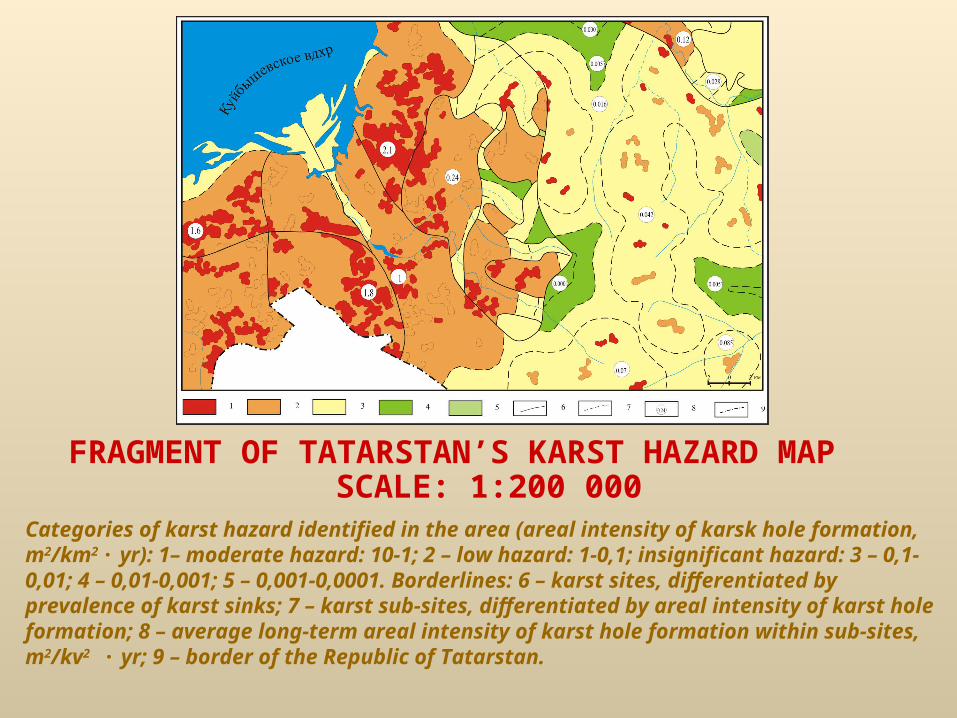
FRAGMENT OF TATARSTANrsquoS KARST HAZARD MAP SCALE 1200 000
Categories of karst hazard identified in the area (areal intensity of karsk hole formation m2km2 middot yr) 1ndash moderate hazard 10-1 2 ndash low hazard 1-01 insignificant hazard 3 ndash 01-001 4 ndash 001-0001 5 ndash 0001-00001 Borderlines 6 ndash karst sites differentiated by prevalence of karst sinks 7 ndash karst sub-sites differentiated by areal intensity of karst hole formation 8 ndash average long-term areal intensity of karst hole formation within sub-sites m2kv2 middot yr 9 ndash border of the Republic of Tatarstan
NATURAL HAZARD VULNERABILITY ASSESSMENT OF TERRITORIES CONSTRUCTION PROJECTS AND
POPULATION
bull What is the current andor future use of the particular territory
bull Which kinds of objects ndash in terms of purpose and structural units - are located andor will be located within the particular territory
bull What is the number distribution and mobility of population within the particular territory and in objects
bull How vulnerable are specific segments of the territory objects systems and population to anticipated natural hazards of particular type and intensity
bull What is the expected vulnerability of future protective engineering structures and protected territories future construction projects and their inhabitants to natural hazards
ASSESSMENT OF VULNERABILITY OF ELEMENTS-AT-RISK TO NATURAL HAZARDS
Types of Vulnerability
bull Physical - Vf(H) = nin
bull Economic - Ve(H) = DiD = Vf(H)Ki
bull Social - Vs(H) = pip
bull Environmental - Vec(H) = xix
Vec(H) = SiS
Vec(H) = DiD=Vec(H) Ki
COMPARATIVE AVERAGE VALUES OF ECONOMIC VULNERABILITY OF BUILDINGS TO VARIOUS NATURAL AND
TECHNOGENIC PROCESSES
Type of Building Hazardous Processes
Construction Type and MaterialEarthquakes (scale points)
Strip
Seiche-wind driven tide
Foundation type (seismic resistance index
according to MMSK-86)
Slab
Pile pier
Strip
SlabPile pier
Slab
Pile pier
Pile pier
Pile pier
Pile pier
Pile pier
Slab
Slab
Slab
Slab
Strip
Strip
Strip
Strip
Land submergence
Low rise buildings of rubble stone adobe puddle wall
Standard buildings of flame brick M-10 mortar
Standard buildings with RC or steel frame without seismic protection features
Brick and sawn stone buildings with design seismic resistance up to 8 points
Frame and large panel buildings with design seismic resistance up to 8 points
Frame and large panel buildings with design seismic resistance up to 8 points
Brick and sawn stone buildings with design seismic resistance up to 7 points
Vulnerability of buildings and
structures
Vulnerability of population in buildings and structures of different height (1
1-4 storey buildings 5-10 storey buildings Over 10 storey buildings
0005 0000006 - 00001 0000006 - 00001 0000006 - 00001
005 000006 - 0001 000006 - 0001 000006 - 0001
01 00003 - 007 00003 - 008 000030 - 009
02 00006 - 015 00006 - 016 00007 - 017
03 0003 - 025 0003 - 027 0004 - 028
04 00052 - 035 00052 - 038 00061 - 039
05 0015 - 045 0015 - 048 0018 - 049
06 0031 - 055 0031 - 058 0038 - 059
07 0047 - 065 005 - 068 0059 - 069
08 0064 - 075 007 - 78 008 - 079
09 042 - 085 05 - 88 054 - 089
10 07 - 091 08 - 096 09 - 099
CORRELATION BETWEEN ECONOMIC VULNERABILITY OF RAPIDLY DEGRADING BUILDINGSSTRUCTURES TO GEOLOGIC AND OTHER
NATURALTECHNOLOGICAL HAZARDS AND VULNERABILITY OF THEIR INHABITANTS
Note 1 Average and average maximum figures
NATURAL HAZARDS ASSESSMENT
middot What are the possible scenarios and consequences of natural hazards
middot What is the probability of those scenarios being triggered
middot What will be the losses from individual episodes and from all of the natural hazards
middot What will be the differential and integrated loss risks from individual episodes and from all of the natural hazards
middot How will the scenarios probabilities losses and differential and integrated risks modify after preventive measures are taken
KEY ELEMENTS OF GEOLOGICAL RISK
Hazard Р(Н)
Risk
P(H)P(FH)
Object (vulnerability)
P(FH)
Geological hazard (H) ndash a process quality or condition of certain lithospheric masses that pose can endanger human life economic facilities or the environment
Vulnerability P(F|H) ndash extent to which the object can lose capacity to perform its natural or assigned functions as a result of adverse external andor internal effects
Risk geological R(H) ndash a measure of probability of geological hazard estimated for a particular object (entity) in terms of possible losses during a certain period
1 Rf (H) = P(H)middotP(F|H) ndash Risk ndash probability of an adverse event (failure)
2 Rd(H) = P(F|H)middotD ndash Risk ndash possible loss
3 Ro (H) = P(H)middotP(S|H)middotP(T|H)middotP(O|H)middotD ndash Combined (integrated) risk
P(H) ndash frequency of hazard (H) numerically equal to its statistical probability
P(F|H) ndash probability of failure (damage destruction death etc) of object when affected by hazard (H) (general vulnerability of object)
D ndash conditional total loss from hazard (H)
P(S|H) ndash probability of being affected by hazard in space (H) (spatial vulnerability)
P(T|H) ndash probability of being affected by hazard (H) in time (temporal vulnerability)
P(O|H) ndash probability of being destroyed (damaged etc) by hazard (H) (physical vulnerability)
NATURAL HAZARD RISK ASSESSMENT
Types of risk by type of effect
bull one-time (subdivided into single and multiple) ndash
- Re(H) = P(H) middot Ve(H) middot Dе
bull permanent ndash R(H) = Vn middot P(Vn ) middot dе
Types of risk by nature of losses
bull natural physical (annual number of objects affected with differential outcomes buildingsyear bridgesyear kmyear etc)
bull natural economic (rublesyear)
bull specific natural economic (rubleshectaremiddotyear rublekm2middotyear)
bull natural social (persyear)
bull natural individual (perspersmiddotyear)
FRAGMENT OF KARST-RELATED ECONOMIC RISK MAP OF REPUBLIC OF TATARSTAN SCALE 1200 000 (SCHEMATIZED (А) AND COMPLETE (Б) VERSIONS)Karst-related economic risk (currency unitsyrmiddotkm2)1 ndash (1 - 01) 2 ndash (01 - 001) 3 ndash (001 - 0001) 4 ndash (0001 - 00001) 5 ndash (00001 - 000001) Borderlines 6 ndash Natural-Technogenic Spheres (NTS) of 2nd order as numbered differentiated by areal intensity of karst hole formation 7 ndash NTS groups of 2nd order differentiated by categories of specific karst-related economic risk 8 ndash automobile roads
FRAGMENT OF KARST-RELATED INDIVIDUAL RISK MAP OF REPUBLIC OF TATARSTAN SCALE 1200 000 (SCHEMATIZED (А) AND COMPLETE (Б) VERSIONS)Individual risk (perspersmiddotyear) medium 1 ndash (10 -7 - 10 -6) small 2 ndash (1middot10 -8 - 1middot10 -9)3 ndash (1middot10 -9 - 1middot10 -12) 4 ndash (lt1middot10 -12) Borderlines 5 ndash NTS of 2nd order as numbered differentiated by areal intensity of karst hole formation 6 ndash NTS groups of 2nd order differentiated by categories of karts-related individual social risk
FRAGMENTS OF FORECAST MAPS INUNDATION ABRASION SEICHE AND SEISMIC CHANGE (1) TYPIFICATION OF ECONOMIC ENTITIES (2) AND ENVIRONMENTAL RISKS RESULTING FROM HAZARDOUS SYNERGETIC PROCESSES ASSOCIATED WITH RAISING CASPIAN SEA LEVEL (3) CITY OF MAKHACHKALA UP TO 2005 Territories of possible exposure to various sets of synergetic processes 1 inundation abrasion submergence (groundwater depth up to 2 m) seismic forces 2 seiche and submergence (up to 2 m) seismic forces 3 submergence ((groundwater depth 2 to 4 m) seismic forces 4 seismic forces Borderlines 5 main zoning taxons on maps A B and C sub-taxons with differentiated 6 seismic activity 7 inundation probability () 8 intensity of seismic forces (scale points) Land use categories 9 utilitystorage 10 industrial 11 transport 12 residential 13 administrativepublic 14 density of national wealth (thous rublesha) Specific economic risk (thous rublesha middotyear) 15 over 400 16 400200 17 200100 18 10030 19 303 20 303 21 03001 22 less than 001
(A) (B) (C)
Integrated Natural Hazard Economic Risk Map of Russia
Integrated Natural Hazard Economic Risk (thous Rubkm3yr)
Small
Moderate
Medium
Substantial
Large
Enormous
Comparative Analysis of Social and Economic Losses from Natural Hazards in Russia
Estimated for specific population groups and economic entities (settlements land property etc) located within areas subject to the respective process Integrated totals of social individual and economic loss risks from natural hazards are estimated for the whole of Russia Figures in parentheses correspond to numbers of cities susceptible to the process
Processes usually resulting in major loss of human life
Processes that usually claim a few human lives
Processes usually resulting in major loss of human life
SusceptibilityAverage long-term risk Probable One-time Loss
Social (thou People)
Social (thou persyear)
Economic ($bn)
Killed
Wounded
Processes Individual (perspers
year) Economic ($bn)year
territories by area
settlements by number
population
Earthquake Tsunami Flood
Landslide rock slide
Avalanche Wildfire Mudflow Karst Suffosion
Marginal erosion of seas and reservoirs
Severe frost snowstorm Hurricane tornado
Water logging
Sheet and gully erosion Riverbed erosion Geocryological rebound thermokarst thermoerosion solifluction
Loess Subsidence
Drought
Total (averages)
Natural Hazard Risk Management
bull Which measures are anticipated to reduce and prevent risk
bull What levels of risk should be considered as acceptable bull What methods arewill be used to monitor natural
hazards facilities status losses and risks bull How do the inhabitants and governments perceive
identified hazards risks and preventioncontrol measures
bull Which additional measures are needed to reduce and control the remaining risks
Principal Levels of Natural Hazard Risk Assessment and Management
Levels of Assessment and Management
Typical Elements-at-Risk
Key Documentation
Level of detail (scale) of assessment and relevant
maps
Local
Local
by object
Individual buildings structures and their parts
Feasibility studies for construction investment
Construction designs and facilities protection schemes
150 ndash 1500
Local by area (municipal)
Settlements urban districts and neighborhoods industrial complexes
General and detailed housing layouts city and neighborhood development plans
Feasibility studies for investment in industrial complexes Protection plans and projects for
such facilities
11000 ndash 110000
Regional
Sub-regional (city district)
Cities urban conglomerates administrative areas within RF
constituent regions local reservoirs and lakes product pipelines roads
and other line structures
Master plans and maps of cities and administrative areas their protection
schemes Feasibility studies for major construction projects construction designs
and protection schemes
110000 - 150000
Regional (sub-federal)
RF constituent regions and their parts major reservoirs lakes and
seas main product pipelines roads and other line structures
Programs to ensure safety and development of production capacities and industries All-inclusive master plans for land management and protection from natural and technological
hazards Feasibility studies for major construction projects construction designs
1100000 - 11000000
Global
Sub-global (Federal District federal national)
Russia as a whole administrative districts and other major territorial
subdivisions
Programs to ensure safety and development of production capacities and industries
General settlement and production layouts naturaltechnological hazards protection
plans
11000000 - 110000000
Global
Earth as a whole individual continents and their major parts
areas spanning several countries
Declarations concepts programs agreements on cooperation and measures to reduce losses from natural and technological
hazards
110000000 and smaller
NATURAL HAZARDS ANALYSIS - GENERAL FLOW CHART
Hazard identification
Hazard forecasting
Risk management
Risk assessment
Vulnerability assessment
IDENTIFICATION OF NATURAL
HAZARDS
bull What kinds of natural hazards ndash in terms of their genesis development mechanism and intensity ndash have affected the area under assessment where and when
bull Which natural or technogenic conditions and trigger factors have brought about or intensified those hazards
bull What is annual probability (frequency) and intensity of different genetic types and forms of natural hazards in certain parts of the area under assessment (volume velocity affected area duration and other measures of destructive capacity of respective hazards)
SYNERGETIC MODEL DESCRIBING THE EMERGENCE OF PRIMARY AND SECONDARY HAZARDS RELATED TO EARTHQUAKES AND TECHNOGENIC FLOODING Linkages 1 2 and the like indicate accordingly the sequence of emergence and augmentation of negative effects
Generation of tsunami waves
Shoreline
erosion
Generation of mud streams resulting from slide dam and glacial dam erosion
Generation of land slides rock slides avalanches glacier surges river closing
Discharge of tensions in earth crust in the form of seismic shocks
Loss of strength liquescency leakage and budging of dispersed rock formations
Rupture settling uplifting subsidence and horizontal movement of land surface
Leakages from water conduits and technogenic submergence of land
FORECASTING NATURAL HAZARDS
bull Given natural and technogenic conditions which types of natural hazards ndash in terms of their genesis and development mechanism ndash can affect the area under assessment and where
bull Which natural hazards can be generated or triggered in the process of anticipated new construction and operation of buildings structures and their systems
bull What is the future annual frequency and intensity of those hazards under the current and altered natural and technogenic conditions
FRAGMENT OF TATARSTANrsquoS KARST HAZARD MAP SCALE 1200 000
Categories of karst hazard identified in the area (areal intensity of karsk hole formation m2km2 middot yr) 1ndash moderate hazard 10-1 2 ndash low hazard 1-01 insignificant hazard 3 ndash 01-001 4 ndash 001-0001 5 ndash 0001-00001 Borderlines 6 ndash karst sites differentiated by prevalence of karst sinks 7 ndash karst sub-sites differentiated by areal intensity of karst hole formation 8 ndash average long-term areal intensity of karst hole formation within sub-sites m2kv2 middot yr 9 ndash border of the Republic of Tatarstan
NATURAL HAZARD VULNERABILITY ASSESSMENT OF TERRITORIES CONSTRUCTION PROJECTS AND
POPULATION
bull What is the current andor future use of the particular territory
bull Which kinds of objects ndash in terms of purpose and structural units - are located andor will be located within the particular territory
bull What is the number distribution and mobility of population within the particular territory and in objects
bull How vulnerable are specific segments of the territory objects systems and population to anticipated natural hazards of particular type and intensity
bull What is the expected vulnerability of future protective engineering structures and protected territories future construction projects and their inhabitants to natural hazards
ASSESSMENT OF VULNERABILITY OF ELEMENTS-AT-RISK TO NATURAL HAZARDS
Types of Vulnerability
bull Physical - Vf(H) = nin
bull Economic - Ve(H) = DiD = Vf(H)Ki
bull Social - Vs(H) = pip
bull Environmental - Vec(H) = xix
Vec(H) = SiS
Vec(H) = DiD=Vec(H) Ki
COMPARATIVE AVERAGE VALUES OF ECONOMIC VULNERABILITY OF BUILDINGS TO VARIOUS NATURAL AND
TECHNOGENIC PROCESSES
Type of Building Hazardous Processes
Construction Type and MaterialEarthquakes (scale points)
Strip
Seiche-wind driven tide
Foundation type (seismic resistance index
according to MMSK-86)
Slab
Pile pier
Strip
SlabPile pier
Slab
Pile pier
Pile pier
Pile pier
Pile pier
Pile pier
Slab
Slab
Slab
Slab
Strip
Strip
Strip
Strip
Land submergence
Low rise buildings of rubble stone adobe puddle wall
Standard buildings of flame brick M-10 mortar
Standard buildings with RC or steel frame without seismic protection features
Brick and sawn stone buildings with design seismic resistance up to 8 points
Frame and large panel buildings with design seismic resistance up to 8 points
Frame and large panel buildings with design seismic resistance up to 8 points
Brick and sawn stone buildings with design seismic resistance up to 7 points
Vulnerability of buildings and
structures
Vulnerability of population in buildings and structures of different height (1
1-4 storey buildings 5-10 storey buildings Over 10 storey buildings
0005 0000006 - 00001 0000006 - 00001 0000006 - 00001
005 000006 - 0001 000006 - 0001 000006 - 0001
01 00003 - 007 00003 - 008 000030 - 009
02 00006 - 015 00006 - 016 00007 - 017
03 0003 - 025 0003 - 027 0004 - 028
04 00052 - 035 00052 - 038 00061 - 039
05 0015 - 045 0015 - 048 0018 - 049
06 0031 - 055 0031 - 058 0038 - 059
07 0047 - 065 005 - 068 0059 - 069
08 0064 - 075 007 - 78 008 - 079
09 042 - 085 05 - 88 054 - 089
10 07 - 091 08 - 096 09 - 099
CORRELATION BETWEEN ECONOMIC VULNERABILITY OF RAPIDLY DEGRADING BUILDINGSSTRUCTURES TO GEOLOGIC AND OTHER
NATURALTECHNOLOGICAL HAZARDS AND VULNERABILITY OF THEIR INHABITANTS
Note 1 Average and average maximum figures
NATURAL HAZARDS ASSESSMENT
middot What are the possible scenarios and consequences of natural hazards
middot What is the probability of those scenarios being triggered
middot What will be the losses from individual episodes and from all of the natural hazards
middot What will be the differential and integrated loss risks from individual episodes and from all of the natural hazards
middot How will the scenarios probabilities losses and differential and integrated risks modify after preventive measures are taken
KEY ELEMENTS OF GEOLOGICAL RISK
Hazard Р(Н)
Risk
P(H)P(FH)
Object (vulnerability)
P(FH)
Geological hazard (H) ndash a process quality or condition of certain lithospheric masses that pose can endanger human life economic facilities or the environment
Vulnerability P(F|H) ndash extent to which the object can lose capacity to perform its natural or assigned functions as a result of adverse external andor internal effects
Risk geological R(H) ndash a measure of probability of geological hazard estimated for a particular object (entity) in terms of possible losses during a certain period
1 Rf (H) = P(H)middotP(F|H) ndash Risk ndash probability of an adverse event (failure)
2 Rd(H) = P(F|H)middotD ndash Risk ndash possible loss
3 Ro (H) = P(H)middotP(S|H)middotP(T|H)middotP(O|H)middotD ndash Combined (integrated) risk
P(H) ndash frequency of hazard (H) numerically equal to its statistical probability
P(F|H) ndash probability of failure (damage destruction death etc) of object when affected by hazard (H) (general vulnerability of object)
D ndash conditional total loss from hazard (H)
P(S|H) ndash probability of being affected by hazard in space (H) (spatial vulnerability)
P(T|H) ndash probability of being affected by hazard (H) in time (temporal vulnerability)
P(O|H) ndash probability of being destroyed (damaged etc) by hazard (H) (physical vulnerability)
NATURAL HAZARD RISK ASSESSMENT
Types of risk by type of effect
bull one-time (subdivided into single and multiple) ndash
- Re(H) = P(H) middot Ve(H) middot Dе
bull permanent ndash R(H) = Vn middot P(Vn ) middot dе
Types of risk by nature of losses
bull natural physical (annual number of objects affected with differential outcomes buildingsyear bridgesyear kmyear etc)
bull natural economic (rublesyear)
bull specific natural economic (rubleshectaremiddotyear rublekm2middotyear)
bull natural social (persyear)
bull natural individual (perspersmiddotyear)
FRAGMENT OF KARST-RELATED ECONOMIC RISK MAP OF REPUBLIC OF TATARSTAN SCALE 1200 000 (SCHEMATIZED (А) AND COMPLETE (Б) VERSIONS)Karst-related economic risk (currency unitsyrmiddotkm2)1 ndash (1 - 01) 2 ndash (01 - 001) 3 ndash (001 - 0001) 4 ndash (0001 - 00001) 5 ndash (00001 - 000001) Borderlines 6 ndash Natural-Technogenic Spheres (NTS) of 2nd order as numbered differentiated by areal intensity of karst hole formation 7 ndash NTS groups of 2nd order differentiated by categories of specific karst-related economic risk 8 ndash automobile roads
FRAGMENT OF KARST-RELATED INDIVIDUAL RISK MAP OF REPUBLIC OF TATARSTAN SCALE 1200 000 (SCHEMATIZED (А) AND COMPLETE (Б) VERSIONS)Individual risk (perspersmiddotyear) medium 1 ndash (10 -7 - 10 -6) small 2 ndash (1middot10 -8 - 1middot10 -9)3 ndash (1middot10 -9 - 1middot10 -12) 4 ndash (lt1middot10 -12) Borderlines 5 ndash NTS of 2nd order as numbered differentiated by areal intensity of karst hole formation 6 ndash NTS groups of 2nd order differentiated by categories of karts-related individual social risk
FRAGMENTS OF FORECAST MAPS INUNDATION ABRASION SEICHE AND SEISMIC CHANGE (1) TYPIFICATION OF ECONOMIC ENTITIES (2) AND ENVIRONMENTAL RISKS RESULTING FROM HAZARDOUS SYNERGETIC PROCESSES ASSOCIATED WITH RAISING CASPIAN SEA LEVEL (3) CITY OF MAKHACHKALA UP TO 2005 Territories of possible exposure to various sets of synergetic processes 1 inundation abrasion submergence (groundwater depth up to 2 m) seismic forces 2 seiche and submergence (up to 2 m) seismic forces 3 submergence ((groundwater depth 2 to 4 m) seismic forces 4 seismic forces Borderlines 5 main zoning taxons on maps A B and C sub-taxons with differentiated 6 seismic activity 7 inundation probability () 8 intensity of seismic forces (scale points) Land use categories 9 utilitystorage 10 industrial 11 transport 12 residential 13 administrativepublic 14 density of national wealth (thous rublesha) Specific economic risk (thous rublesha middotyear) 15 over 400 16 400200 17 200100 18 10030 19 303 20 303 21 03001 22 less than 001
(A) (B) (C)
Integrated Natural Hazard Economic Risk Map of Russia
Integrated Natural Hazard Economic Risk (thous Rubkm3yr)
Small
Moderate
Medium
Substantial
Large
Enormous
Comparative Analysis of Social and Economic Losses from Natural Hazards in Russia
Estimated for specific population groups and economic entities (settlements land property etc) located within areas subject to the respective process Integrated totals of social individual and economic loss risks from natural hazards are estimated for the whole of Russia Figures in parentheses correspond to numbers of cities susceptible to the process
Processes usually resulting in major loss of human life
Processes that usually claim a few human lives
Processes usually resulting in major loss of human life
SusceptibilityAverage long-term risk Probable One-time Loss
Social (thou People)
Social (thou persyear)
Economic ($bn)
Killed
Wounded
Processes Individual (perspers
year) Economic ($bn)year
territories by area
settlements by number
population
Earthquake Tsunami Flood
Landslide rock slide
Avalanche Wildfire Mudflow Karst Suffosion
Marginal erosion of seas and reservoirs
Severe frost snowstorm Hurricane tornado
Water logging
Sheet and gully erosion Riverbed erosion Geocryological rebound thermokarst thermoerosion solifluction
Loess Subsidence
Drought
Total (averages)
Natural Hazard Risk Management
bull Which measures are anticipated to reduce and prevent risk
bull What levels of risk should be considered as acceptable bull What methods arewill be used to monitor natural
hazards facilities status losses and risks bull How do the inhabitants and governments perceive
identified hazards risks and preventioncontrol measures
bull Which additional measures are needed to reduce and control the remaining risks
Principal Levels of Natural Hazard Risk Assessment and Management
Levels of Assessment and Management
Typical Elements-at-Risk
Key Documentation
Level of detail (scale) of assessment and relevant
maps
Local
Local
by object
Individual buildings structures and their parts
Feasibility studies for construction investment
Construction designs and facilities protection schemes
150 ndash 1500
Local by area (municipal)
Settlements urban districts and neighborhoods industrial complexes
General and detailed housing layouts city and neighborhood development plans
Feasibility studies for investment in industrial complexes Protection plans and projects for
such facilities
11000 ndash 110000
Regional
Sub-regional (city district)
Cities urban conglomerates administrative areas within RF
constituent regions local reservoirs and lakes product pipelines roads
and other line structures
Master plans and maps of cities and administrative areas their protection
schemes Feasibility studies for major construction projects construction designs
and protection schemes
110000 - 150000
Regional (sub-federal)
RF constituent regions and their parts major reservoirs lakes and
seas main product pipelines roads and other line structures
Programs to ensure safety and development of production capacities and industries All-inclusive master plans for land management and protection from natural and technological
hazards Feasibility studies for major construction projects construction designs
1100000 - 11000000
Global
Sub-global (Federal District federal national)
Russia as a whole administrative districts and other major territorial
subdivisions
Programs to ensure safety and development of production capacities and industries
General settlement and production layouts naturaltechnological hazards protection
plans
11000000 - 110000000
Global
Earth as a whole individual continents and their major parts
areas spanning several countries
Declarations concepts programs agreements on cooperation and measures to reduce losses from natural and technological
hazards
110000000 and smaller
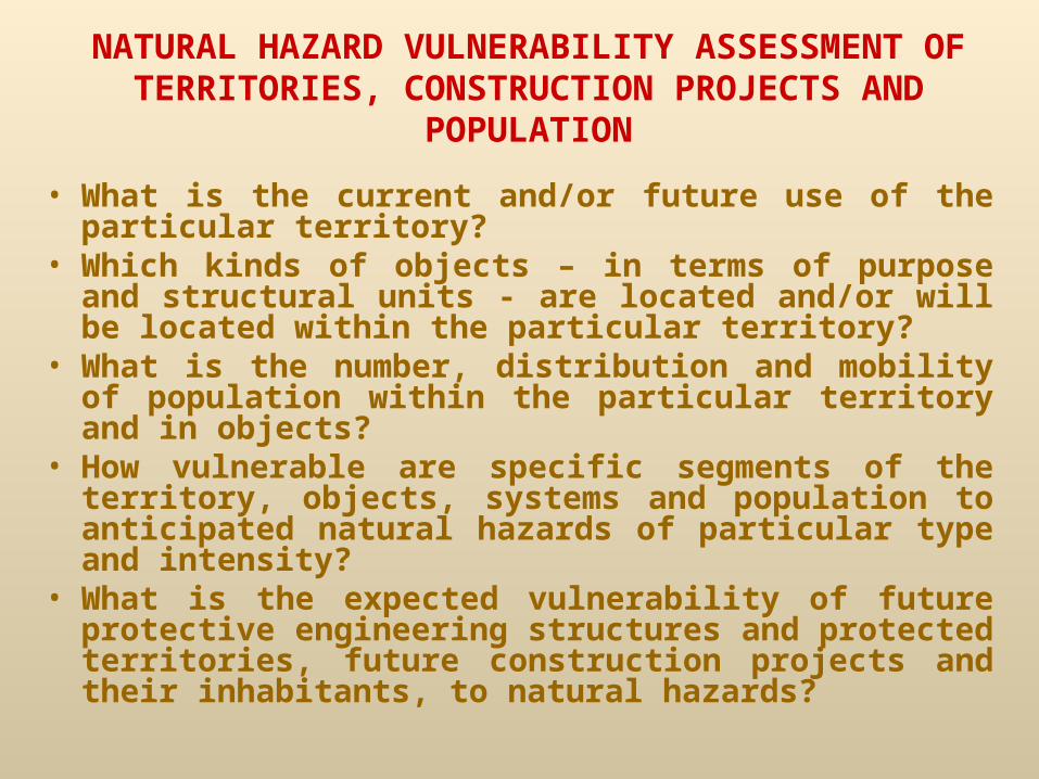
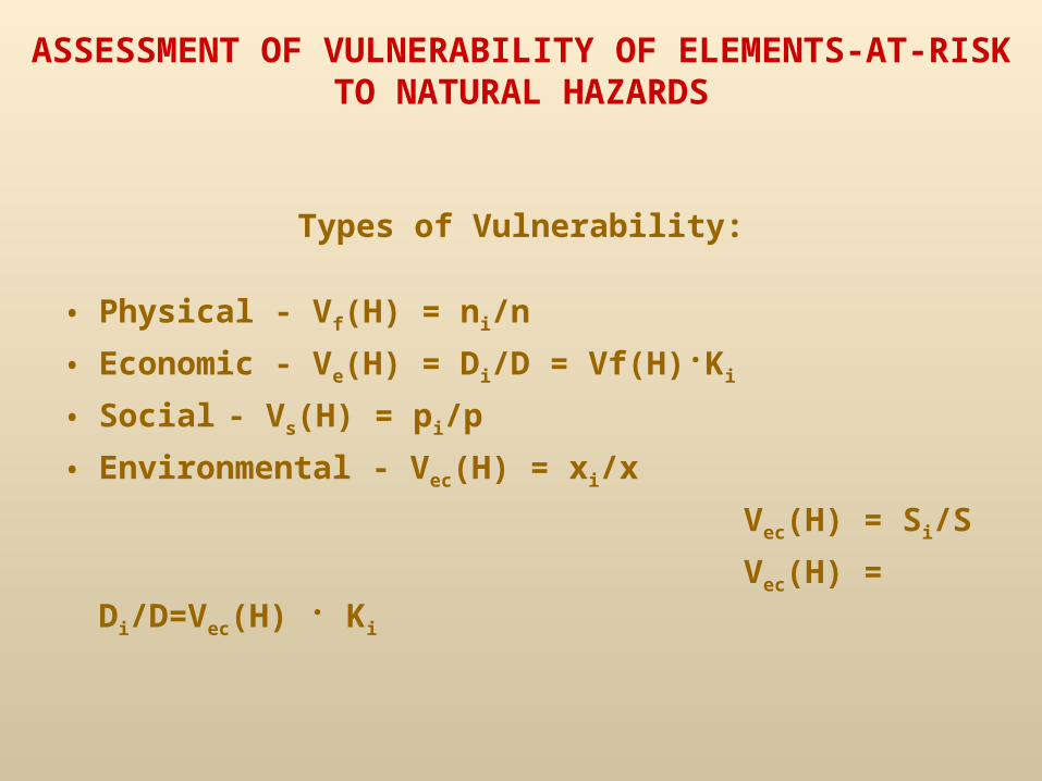
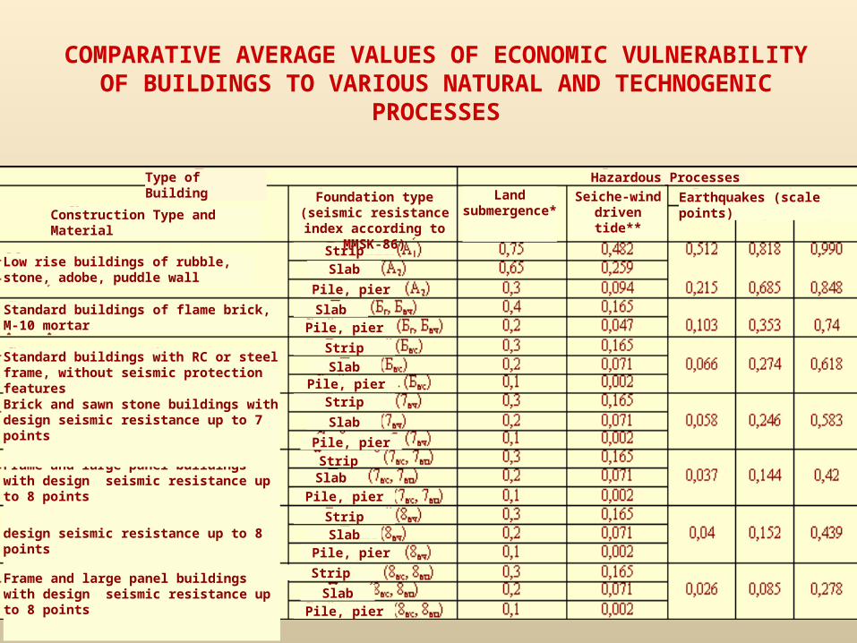
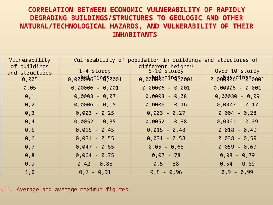
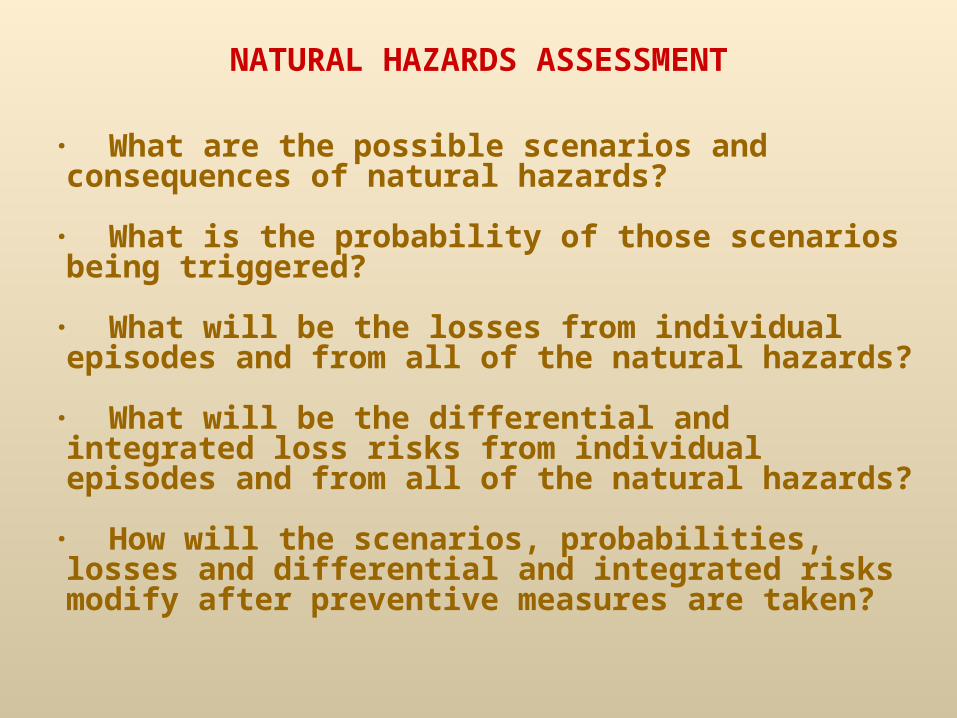
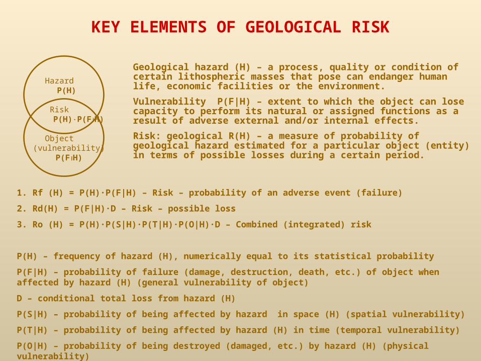
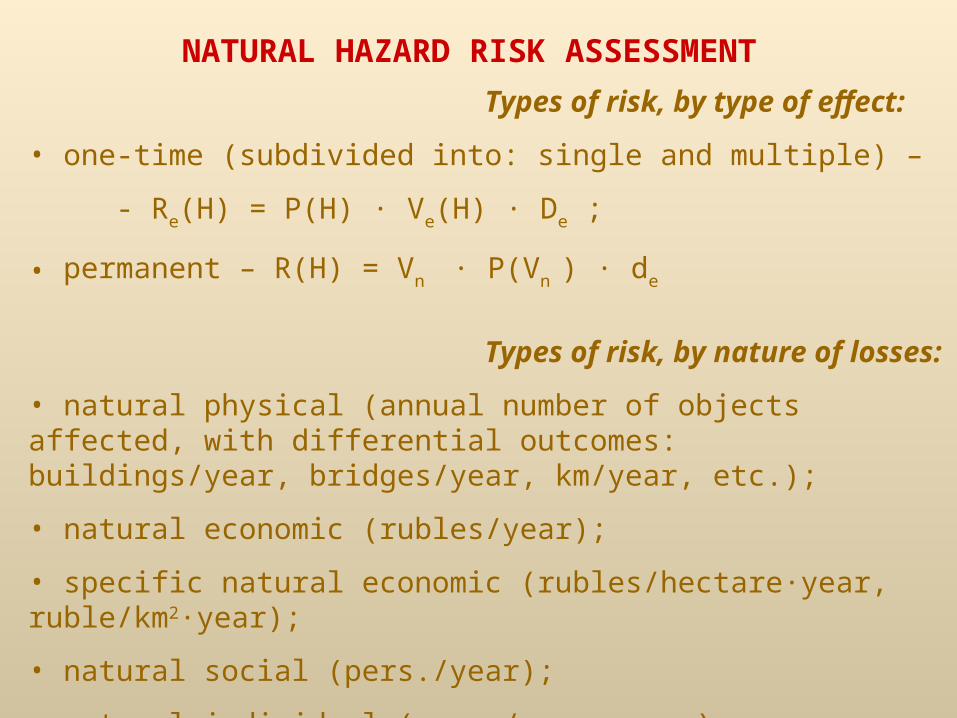
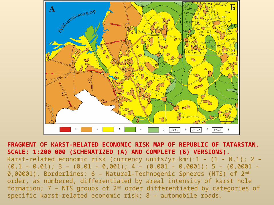
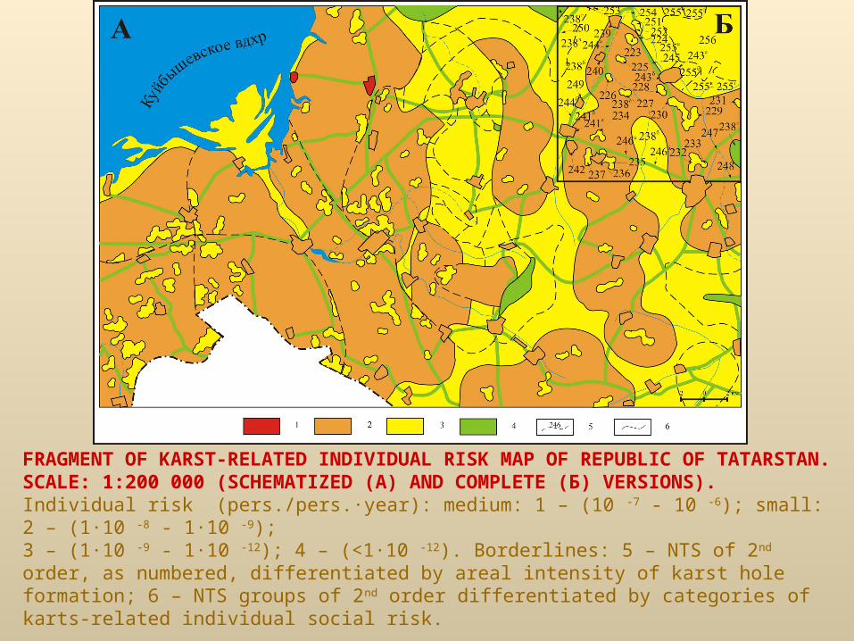
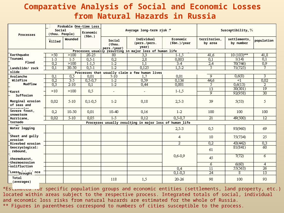
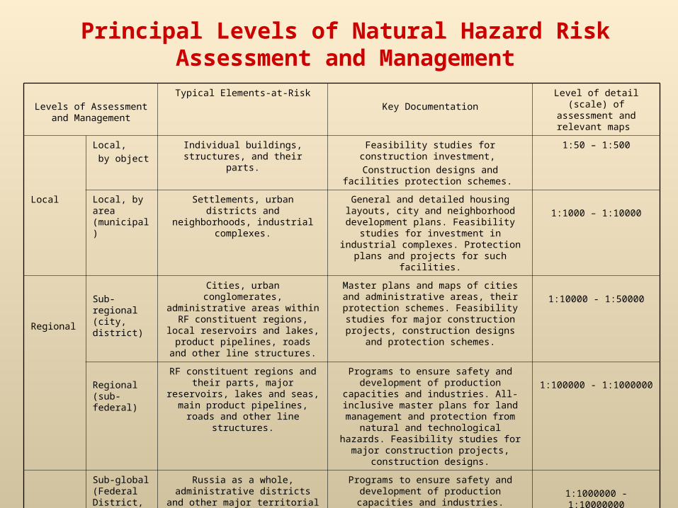