Embed Size (px)
Citation preview
ARIZONA'S PREHISTORIC CANALS, FROM THE AIR
BY
NEIL M. JUDDCurator, Division of Archeology, U. S. National Museum
(From "Explorations and Field-Work of theSmithsonian Institution in 1930")
WASHINGTON
1931
ARIZONA'S PREHISTORIC CANALS, FROM THE AIR 1
By NEIL M. JUDD,Curator, Division of Archeology, U. S. National Museum
Out in central Arizona, where cotton fields, citrus groves and datepalms reach out across endless miles to caress jagged igneous andsandstone buttes, prehistoric peoples once erected a noteworthy civili-zation upon an agricultural foundation. That ancient civilization isgone now—lost with the desert acres on which it flourished—andfew traces remain of the gigantic canals that made its primitive agri-culture possible.
But those few traces merit careful preservation. They are all wehave left to remind us of that unnamed, aboriginal folk whose engi-neering achievements .rightfully arrest the attention of our mechanicalage. For those prehistoric canals—it has been estimated that half acentury ago there were no less than 300 miles of them in the SaltRiver valley alone—were so accurately and efficiently constructed thatportions of them, taken over by white settlers of 1870 and thereabouts,are actually in use at the present time. And here is another point weare apt to overlook : Every mile of those ancient channels was lit-erally dug by hand, since the Arizona Indians knew nothing eitherof beasts of burden or metal tools until well on in the seventeenthcentury.
Following the old canal banks, one occasionally happens upon thefragment of a stone "hoe "—a thin blade of igneous rock, chipped onone side to a cutting edge. With such rude tools, with fractured cob-blestones and sharpened sticks, the canal builders hacked and proddedat the hard desert soil. In baskets and blankets, we may safely con-jecture, women and children carried the loosened earth out from theexcavation. Thus, mile after weary mile, an entire community laboredto construct the canals that watered their communal fields.
Nowhere else in the New World has evidence been found of pre-historic irrigation systems comparable to those of central Arizona.They may even have surpassed, both in size and in the number ofacres served, those famous systems of the Tigris and Euphrates val-leys—irrigation works that watered the seed of native ability and
1 In December, 193 0, Mr. Odd S. Halseth, of Phoenix, was continuing. ber-tain studies connected with this aerial survey, in behalf of the Bureau of Ameri-can Ethnology.
157
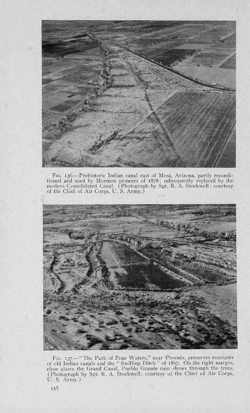
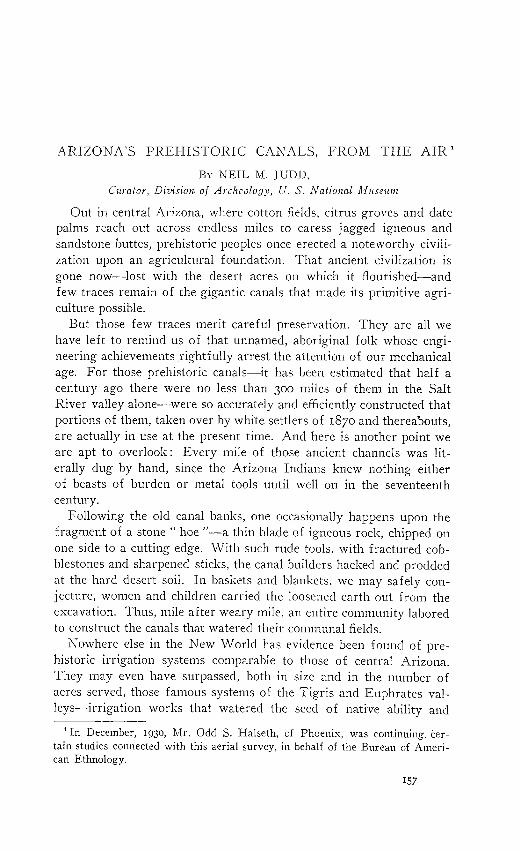
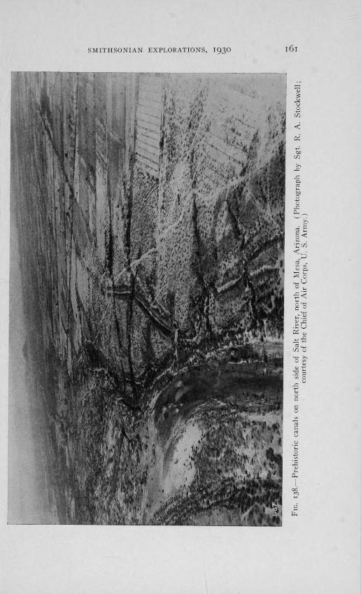
FIG. 136.—Prehistoric Indian canal east of Mesa, Arizona, partly recondi-tioned and used by Mormon pioneers of 1878 ; subsequently replaced by themodern Consolidated Canal. (Photograph by Sgt. R. A. Stockwell ; courtesyof the Chief of Air Corps, U. S. Army.)
FIG. 137.-" The Park of Four Waters," near Phoenix, preserves remnantsof old Indian canals and the " Swilling Ditch " of 5867. On the right margin,close above the Grand Canal, Pueblo Grande ruin shows through the trees.(Photograph by Sgt. R. A. Stockwell ; courtesy of the Chief of Air Corps,U. S. Army.)
153
SMITHSONIAN EXPLORATIONS, 1930 159
brought forth into full bloom high civilizations that made Mesopo-tamia known throughout the ancient world.
With prodigious labor, the Peruvians of pre-Spanish times led ir-rigation ditches along craggy heights of the Andes to their terracedgardens. Among the highlands of Mexico and again in various sec-tions of the southwestern United States, Indian farmers had learnedthat irrigation was necessary to the successful cultivation of foodcrops. In November, 1694, Padre Eusebio Kino stood before the drabwalls of Casa Grande ruin and speculated upon the feasibility ofrestoring its abandoned, overgrown canals. Five hundred years beforeKino was born the inhabitants of Pueblo Bonito, in Chaco Canyon,New Mexico, were capturing the mid-summer rains, taming and guid-ing them onto thirsty fields. But none of these efforts matched thecolossal, prehistoric irrigation systems of the Gila and Salt rivervalleys.
We wanted maps of these latter, hand-made Indian canals. Wewanted to know their extent, their position relative to each other, theapproximate acreage they once watered. Similar desires on the partof other observers had prompted surveys which were not altogethersuccessful for the very simple reason that so little is now visible of theancient ditches. Modern agriculture has been too destructive ; it hasplowed and planted until the aboriginal farming communities and theirworks were pretty thoroughly obliterated. From the ground, one'srange of vision is too limited ; from the air it might be possible torecover data for the maps we had in mind. At least this seemed themost promising, expeditious method when I made a preliminary studyof the situation in the autumn of I929.'
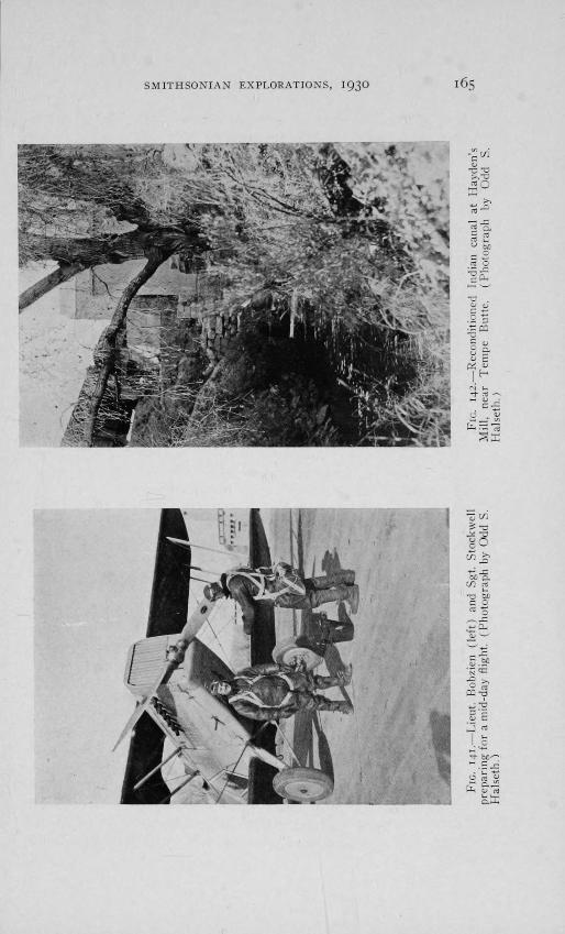
So, at the solicitation of United States Senator Carl Hayden, theSmithsonian Institution and the War Department cooperated in anaerial survey of the Salt and Gila river valleys, beginning late inJanuary, 1930. Lieutenant Edwin Bobzien and Sergeant R. A. Stock-well, pilot and photographer, respectively, were detailed from theAir Corps unit at Crissy Field, San Francisco, and I was designatedSmithsonian representative, to advise with the aviators.
Our small party assembled at Phoenix, blocked out the areas to bephotographed and speedily set to work. Smoke and ground haze drewan impenetrable blanket over Salt River valley each morning andevening, thus restricting flying time to a brief two hours at middaywhen shadows are at a minimum. The longer shadows of early morn-
Explorations and Field-work of the Smithsonian Institution in 1929, pp.177-182. Washington, 1930.
160 SMITHSONIAN INSTITUTION
ing and late afternoon would naturally have thrown into greater reliefthose slight elevations which mark ancient house sites and irrigationditches.
But, despite handicaps of various sorts, our air survey proceededabout as we had planned it. First of all there was the Gila River val-ley, from its union with the Rio Salado to the northwestern slopes ofthe Tortilla Mountains—a far-reaching plain whereon Pima andPapago farmers tilled favored patches of irrigable land long beforethe advent of missionaries, trappers, Pony Express riders, and otherpioneers of a period now all but forgotten.
American settlers trailed into the upper Gila valley during the thirdquarter of the nineteenth century and drew so heavily upon the avail-able water supply that the Indian farmers below were finally broughtto a state of destitution. Government promises of relief were madeand remade but a half century passed before the Coolidge Dam wascompleted and provision thus made to meet the needs of whites andIndians alike. The great reservoir is slowly filling and, 70 miles away,farm lands wait thirstily for the life-giving waters.
With huge, snorting machines that make an Indian's home-madetools seem, by comparison, as nothing at all, 56,000 acres of desertland are being cleared, leveled, and otherwise prepared for irrigationat the rate of 20 acres a day. But the mechanical monsters of themodern engineer are no respecters of prehistoric canals ! The latterwere being destroyed along with other heritages from the past. Ourswas the task of discerning and recording some vestige of those ancientirrigation systems while fleeting opportunity permitted.
Up one side of the Gila and down the other, Lieutenant Bobzien
held his blue Douglas observation plane on a fixed course at 10,000feet elevation while Sergeant Stockwell pointed his camera through ahole in the floor and snapped the shutter with clock-like precision topicture a square mile on each successive negative. Over famed CasaGrande ruins the ship sailed lower in search of those ancient canalsseen by Kino and which new cotton fields seem to have erased abso-lutely. And then back to the Indian gardens that border the meander-ing Gila from Sacaton to Pima Butte and beyond.
Like strips of Grandmother's quilt those gardens are ! Queer, -mis-shapen patches with thin ribbons of dark green running this way andthat where lesser irrigation ditches crazy-stitched the variegated scrapstogether. Yet, hopelessly confused and insignificant as these minia-ture farms appear from a height of nearly two miles, they played anot unimportant part in the conquest of southern Arizona.
SMITHSONIAN EXPLORATIONS, 1930
161
162 SMITHSONIAN INSTITUTION
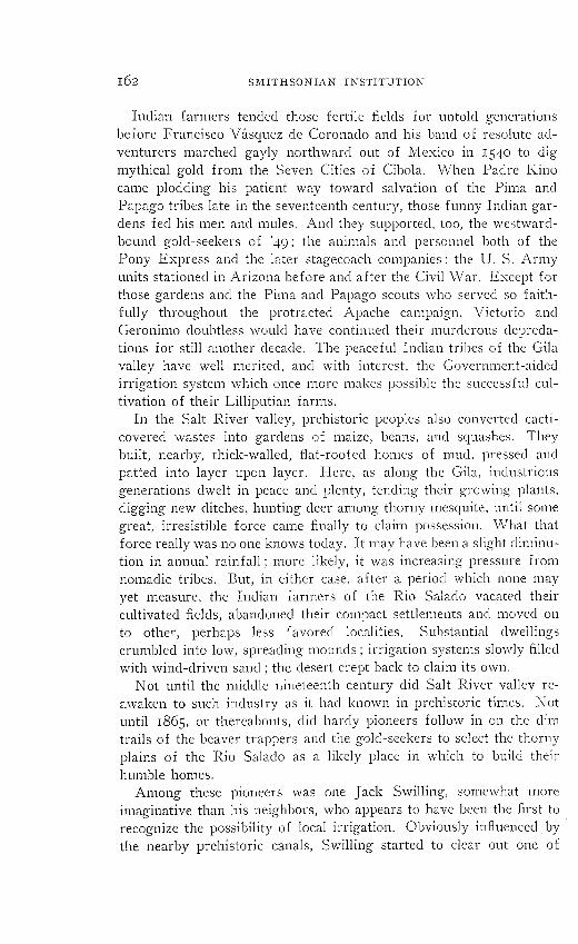
Indian farmers tended those fertile fields for untold generationsbefore Francisco Va.squez de Coronado and his band of resolute ad-venturers marched gayly northward out of Mexico in 1540 to digmythical gold from the Seven Cities of Cibola. When Padre Kinocame plodding his patient way toward salvation of the Pirna andPapago tribes late in the seventeenth century, those funny Indian gar-dens fed his men and mules. And they supported, too, the westward-bound gold-seekers of l49 ; the animals and personnel both of thePony Express and the later stagecoach companies ; the U. S. Armyunits stationed in Arizona before and after the Civil War. Except forthose gardens and the Pima and Papago scouts who served so faith-fully throughout the protracted Apache campaign, Victoria andGeronimo doubtless would have continued their murderous depreda-tions for still another decade. The peaceful Indian tribes of the Gilavalley have well merited, and with interest, the Government-aidedirrigation system which once more makes possible the successful cul-tivation of their Lilliputian farms.
In the Salt River valley, prehistoric peoples also converted cacti-covered wastes into gardens of maize, beans, and squashes. Theybuilt, nearby, thick-walled, flat-roofed homes of mud, pressed andpatted into layer upon layer. Here, as along the Gila, industriousgenerations dwelt in peace and plenty, tending their growing plants,digging new ditches, hunting deer among thorny mesquite, until somegreat, irresistible force came finally to claim possession. What thatforce really was no one knows today. It may have been a slight diminu-tion in annual rainfall ; more likely, it was increasing pressure fromnomadic tribes. But, in either case, after a period which none mayyet measure, the Indian farmers of the Rio Salado vacated theircultivated fields, abandoned their compact settlements and moved onto other, perhaps less favored localities. Substantial dwellingscrumbled into low, spreading mounds ; irrigation systems slowly filledwith wind-driven sand ; the desert crept back to claim its own.
Not until the middle nineteenth century did Salt River valley re-awaken to such industry as it had known in prehistoric times: Notuntil 1865, or thereabouts, did hardy pioneers follow in on the dimtrails of the beaver trappers and the gold-seekers to select the thornyplains of the Rio Salado as a likely place in which to build theirhumble homes.
Among these pioneers was one Jack Swilling, somewhat moreimaginative than his neighbors, who appears to have been the first torecognize the possibility of local irrigation. Obviously infiuenced bythe nearby prehistoric canals, Swilling started to clear out one of
SMITHSONIAN EXPLORATIONS, 1930 163
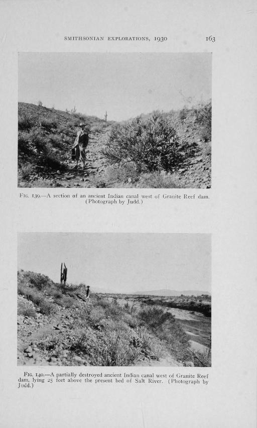
FIG. 139.—A section of all ancient Indian canal west of Granite Reef darn.(Photograph by Judd.)
140.—A partially destroyed ancient Indian canal west of Granite Reefdarn, lying 25 feet above the present bed of Salt River. (Photograph byJudd.)
164
SMITHSONIAN INSTITUTION
these as a ready means of watering his own fields. And then, in1867, he organized the company which constructed the first moderncanal in Salt River valley.
Remnants of this old " Swilling ditch " and sections of three ancientIndian canals are still visible in " The Park of Four Waters," wiselypreserved by the city of Phoenix. Close by stands the ruin of PuebloGrande, a huge pile of crumbling walls and pale yellow clay, excava-tion of which was initiated in 1929 by City Archeologist Odd A.Halseth.
Largest surviving example of the communal dwellings which dottedSalt River valley in prehistoric times, Pueblo Grande marks a formercenter of population from which industrious Indian farmers trudgedforth to their daily toil. From the flat roofs of their earth-walledhomes those same farmers saluted the rising and setting- sun as thefather of all living things. For in olden times, no less than today, thesun meant life to dwellers in Salt River valley.
Over on the south side, Pioneer Charles T. Hayden camped oneday at the foot of Tempe Butte and watched the swollen river racepast. Then he constructed a rude ferry to float his wagons across;remained to transport other early settlers, to build the first local store,walled with mud-plastered willows. More than this, he cleaned outan old Indian canal and drew into it, from the Rio Salado, water withwhich to turn the wheels of his primitive mill. The new Hayden mill,erected on the same site, is no longer powered by an irrigation ditchbut it served, nonetheless, as one of our principal landmarks in therecent aerial survey of Salt River valley.
Mormon settlers came, in 1878, to found the contented village ofMesa; to recondition other abandoned Indian canals and thus savetheir pioneer community an estimated $20,000 in labor alone. Part ofone such rebuilt ditch is still in use but, as elsewhere in the valley,increase in population has brought about larger, more serviceablecanals with their far-flung network of laterals.
Inquiry elicits the information that there are no fewer than 1,200
miles of these modern watercourses. Most of them measure from18 to 90 feet wide at the top and average about five feet in depth; sec-tions of them have cost as much as $22,000 a mile to construct. Butthe prehistoric canal builders, with barefooted helpers instead ofcaterpillar tractors, with stone hoes as precursors of the steam shovel,unhesitatingly set about the completion of comparable works. I pho-tographed one aboriginal canal north of Mesa that stands today 66 feetwide and 8 feet deep. It led from the Rio Salado far across the valley ;
as the river cut its channel below the canal floor, the useless ditch
SMITHSONIAN EXPLORATIONS, 1930 165

I66 SMITHSONIAN INSTITUTION
was replaced by another which connected with a new intake, fartherup stream. Such substitutions were necessitated by altered conditionsin prehistoric times no less than today.
Modern irrigation canals and the industry they symbolize have donemost to erase from central Arizona former vestiges of that nativecivilization which once prospered there. The sad ruins of aboriginalhomes have been leveled with their neighboring fields ; the ditcheswhich once watered those fields have been filled or scraped away.Where Indian farmers eight or ten hundred years ago cultivated gar-dens of beans, maize and squashes, vast acres of cotton, lettuce andmelons are now harvested. Neat orchards of dates and grapefruitflourish where catclaw and mesquite stretched their spiny branchesonly a generation ago. The diabolical Apache has been tamed if notconquered. Bow-legged cowboys, garbed according to the latest fash-ion notes from Hollywood, ride herd on eastern " dudes." Attractivedwellings and sumptuous winter resorts, with green lawns and flower-bordered walks have replaced the mud-walled habitations of theancient folk.
As One looks down from the air upon this Paradise that is SaltRiver valley today, one is impressed first of all by the orderly habitsof mankind. At least there is a semblance of order, from a height of2,000 feet or more. Long, straight roads on which autos slither awaylike headless roaches ; brown and yellow fields all nicely squared ;orange trees that seem as tiny pellets of dark green, patiently arranged,row upon row ; little cubed houses, fringed with flat green things.
Reaching across these fields and under these houses, light or darkstreaks mark former prehistoric Indian canals which only the avia-tor may readily detect. Silt deposited in those old ditches showsdark brown against the drab desert soil ; pale yellow lines remainwhere embankments have been smoothed away. Slight differences invegetation, imperceptible when close at hand, take on color variationsthat enable one at a considerable height to retrace works which other-wise have been wholly effaced.
The blue Army plane glides down from the clouds and back to portwith numbed crew and empty cameras. Camel Back Mountain squatscomplacently at one side and looks out across the valley where suchmomentous changes have taken place within memory of men stillliving. Squaw Peak lifts her unkempt bulk to frown upon this newcivilization, as she did upon the old. A setting sun momentarily gildsthe giant sahuaro whose long, fingered shadows point eastwardly torugged mountain ranges whence flow the life-giving waters of the Gilaand the Rio Salado.