Embed Size (px)
Citation preview
Submitted for publication in the Proceedings: US Hydro 2007, Norfolk, VA, 14-17 May 2007-04-02
Sailing Directions in Digital Formats:
The Real-World in Video
LCDR Andres Millan, Royal Spanish Navy University of New Brunswick
Fredericton, New Brunswick, CANADA Abstract: Most Hydrographic Offices are making an effort to provide traditional nautical publications in digital formats. While useful, most of them are just digital scans of printed publications. In regard to one of the most important publications for the navigator, Sailing Directions, a real improvement can be performed by means of digital multimedia features. It is proposed that digital video film clips embedded in a GIS environment, become a supplemental means to provide additional information to the mariner about coastal descriptions and harbour facilities. A 20-second video clip could easily be equivalent to a hundred pictures and several paragraphs of text. In addition, a video clip can provide on-the-fly verbal narration and superimposed figures. This not only makes the navigator acquire the information more comfortably, it also depicts the real-world situation. The major benefit of video film clips is that they complement – not replace – the use of digital nautical charts and published Sailing Directions. In addition, the incorporation of digital Sailing Directions into GIS software can provide further decision-support capability for Navigators. _________________________________ From some time, the International Hydrographic Organization (IHO) has devoted efforts to convert all traditional paper nautical publications to digital formats. Based on this process, a strategy to implement a digital version of Sailing Directions is suggested. The goal must be to provide the Navigator, when reaching a harbour or a coast, a feeling of familiarity. The Navigator should have a sense that: “I have been here before, and I can identify at a glance all the marine and land features that I have in front of me”. This goal will lead to improve safety at sea by giving the Navigator as much information as possible, and in the most efficient way. Concept of Sailing Directions Sailing Directions are publications that provide important information of interest to navigation which may not necessarily be found on charts or in other marine publications. They are intended
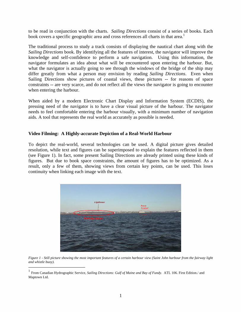
to be read in conjunction with the charts. Sailing Directions consist of a series of books. Each book covers a specific geographic area and cross references all charts in that area.1 The traditional process to study a track consists of displaying the nautical chart along with the Sailing Directions book. By identifying all the features of interest, the navigator will improve the knowledge and self-confidence to perform a safe navigation. Using this information, the navigator formulates an idea about what will be encountered upon entering the harbour. But, what the navigator is actually going to see through the windows of the bridge of the ship may differ greatly from what a person may envision by reading Sailing Directions. Even when Sailing Directions show pictures of coastal views, these pictures -- for reasons of space constraints -- are very scarce, and do not reflect all the views the navigator is going to encounter when entering the harbour. When aided by a modern Electronic Chart Display and Information System (ECDIS), the pressing need of the navigator is to have a clear visual picture of the harbour. The navigator needs to feel comfortable entering the harbour visually, with a minimum number of navigation aids. A tool that represents the real world as accurately as possible is needed. Video Filming: A Highly-accurate Depiction of a Real-World Harbour To depict the real-world, several technologies can be used. A digital picture gives detailed resolution, while text and figures can be superimposed to explain the features reflected in them (see Figure 1). In fact, some present Sailing Directions are already printed using these kinds of figures. But due to book space constraints, the amount of figures has to be optimized. As a result, only a few of them, showing views from certain key points, can be used. This loses continuity when linking each image with the text. Figure 1 - Still picture showing the most important features of a certain harbour view (Saint John harbour from the fairway light and whistle buoy). 1 From Canadian Hydrographic Service, Sailing Directions: Gulf of Maine and Bay of Fundy. ATL 106. First Edition./ and Maptown Ltd.
1
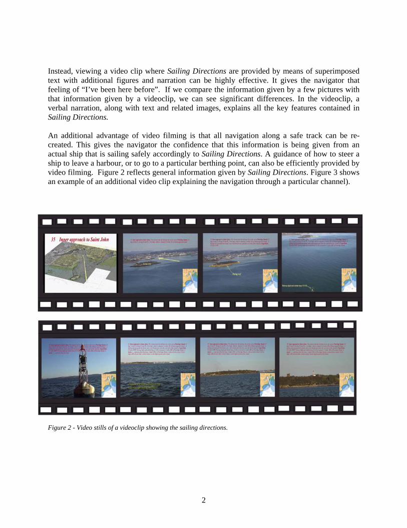
Instead, viewing a video clip where Sailing Directions are provided by means of superimposed text with additional figures and narration can be highly effective. It gives the navigator that feeling of “I’ve been here before”. If we compare the information given by a few pictures with that information given by a videoclip, we can see significant differences. In the videoclip, a verbal narration, along with text and related images, explains all the key features contained in Sailing Directions. An additional advantage of video filming is that all navigation along a safe track can be re-created. This gives the navigator the confidence that this information is being given from an actual ship that is sailing safely accordingly to Sailing Directions. A guidance of how to steer a ship to leave a harbour, or to go to a particular berthing point, can also be efficiently provided by video filming. Figure 2 reflects general information given by Sailing Directions. Figure 3 shows an example of an additional video clip explaining the navigation through a particular channel). Figure 2 - Video stills of a videoclip showing the sailing directions.
2
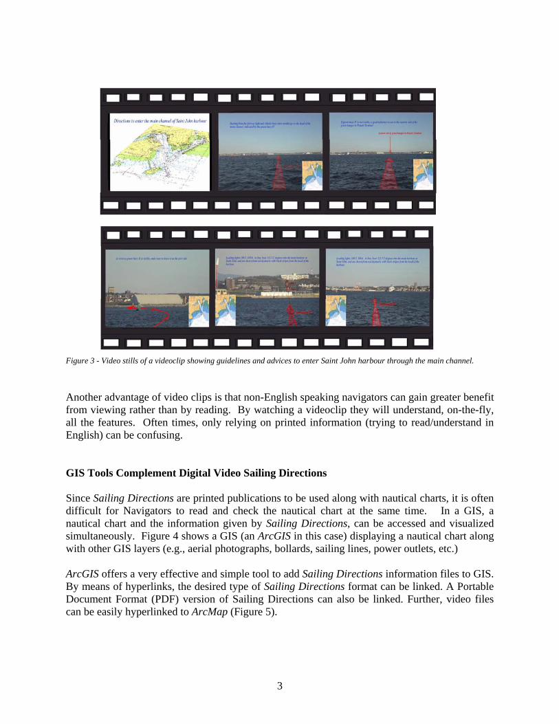
Figure 3 - Video stills of a videoclip showing guidelines and advices to enter Saint John harbour through the main channel. Another advantage of video clips is that non-English speaking navigators can gain greater benefit from viewing rather than by reading. By watching a videoclip they will understand, on-the-fly, all the features. Often times, only relying on printed information (trying to read/understand in English) can be confusing. GIS Tools Complement Digital Video Sailing Directions Since Sailing Directions are printed publications to be used along with nautical charts, it is often difficult for Navigators to read and check the nautical chart at the same time. In a GIS, a nautical chart and the information given by Sailing Directions, can be accessed and visualized simultaneously. Figure 4 shows a GIS (an ArcGIS in this case) displaying a nautical chart along with other GIS layers (e.g., aerial photographs, bollards, sailing lines, power outlets, etc.) ArcGIS offers a very effective and simple tool to add Sailing Directions information files to GIS. By means of hyperlinks, the desired type of Sailing Directions format can be linked. A Portable Document Format (PDF) version of Sailing Directions can also be linked. Further, video files can be easily hyperlinked to ArcMap (Figure 5).
3
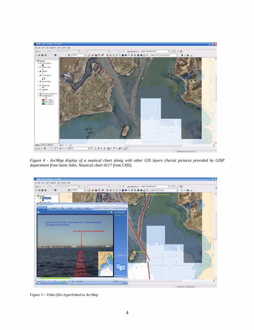
Figure 4 - ArcMap display of a nautical chart along with other GIS layers (Aerial pictures provided by GISP department from Saint John. Nautical chart 4117 from CHS). Figure 5 – Video files hyperlinked to ArcMap
4
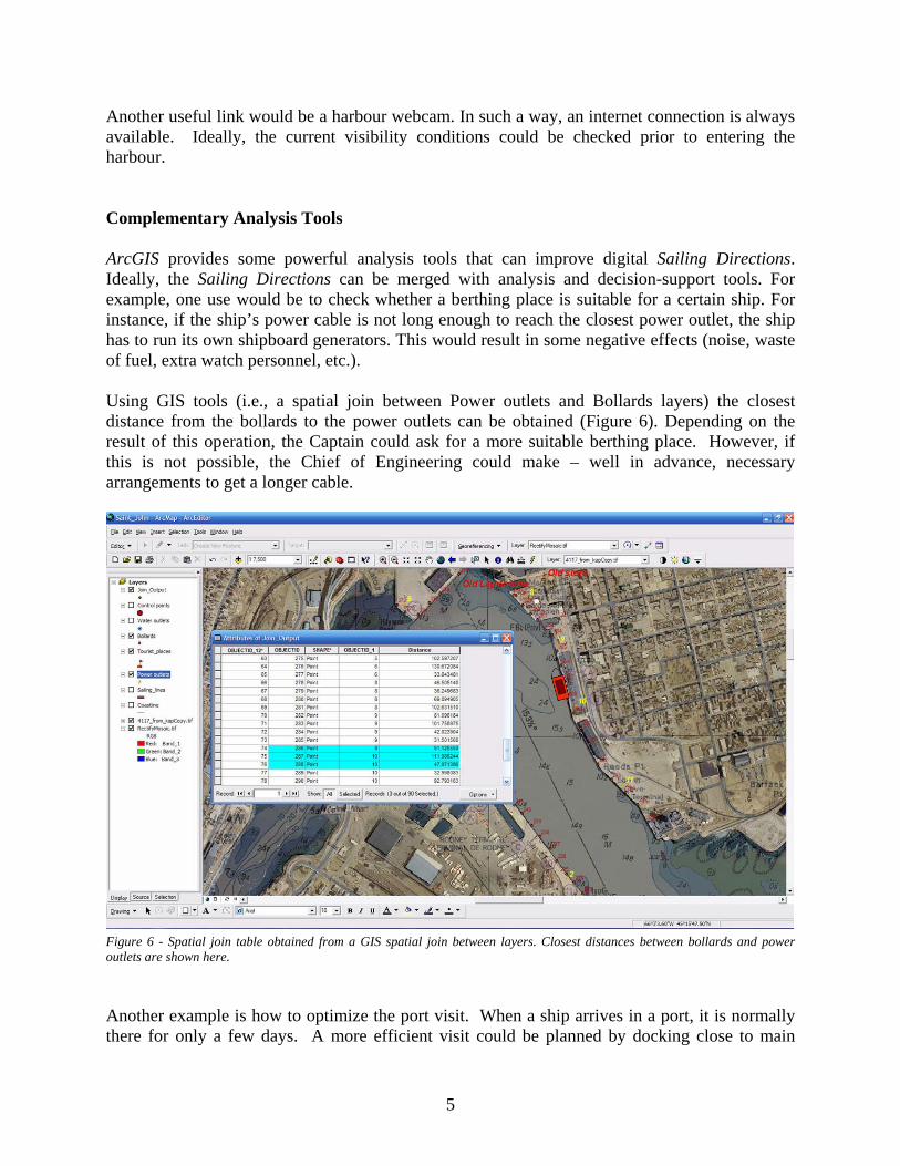
Another useful link would be a harbour webcam. In such a way, an internet connection is always available. Ideally, the current visibility conditions could be checked prior to entering the harbour. Complementary Analysis Tools ArcGIS provides some powerful analysis tools that can improve digital Sailing Directions. Ideally, the Sailing Directions can be merged with analysis and decision-support tools. For example, one use would be to check whether a berthing place is suitable for a certain ship. For instance, if the ship’s power cable is not long enough to reach the closest power outlet, the ship has to run its own shipboard generators. This would result in some negative effects (noise, waste of fuel, extra watch personnel, etc.). Using GIS tools (i.e., a spatial join between Power outlets and Bollards layers) the closest distance from the bollards to the power outlets can be obtained (Figure 6). Depending on the result of this operation, the Captain could ask for a more suitable berthing place. However, if this is not possible, the Chief of Engineering could make – well in advance, necessary arrangements to get a longer cable. Figure 6 - Spatial join table obtained from a GIS spatial join between layers. Closest distances between bollards and power outlets are shown here. Another example is how to optimize the port visit. When a ship arrives in a port, it is normally there for only a few days. A more efficient visit could be planned by docking close to main
5
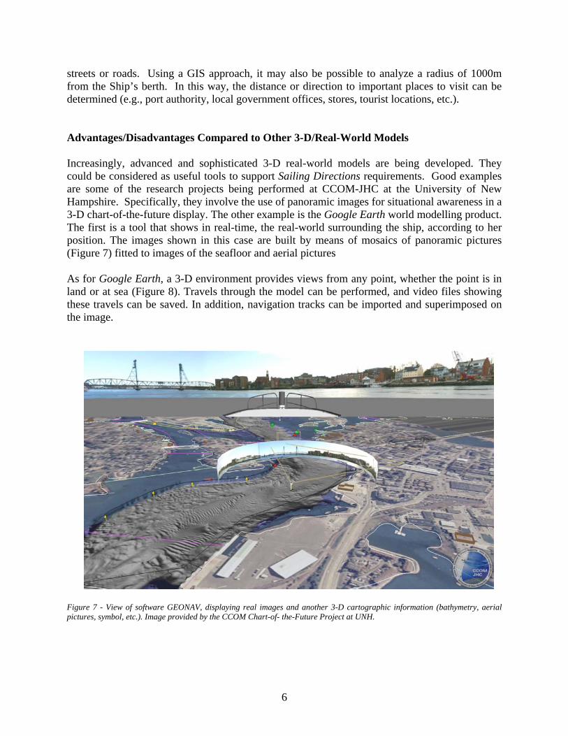
streets or roads. Using a GIS approach, it may also be possible to analyze a radius of 1000m from the Ship’s berth. In this way, the distance or direction to important places to visit can be determined (e.g., port authority, local government offices, stores, tourist locations, etc.). Advantages/Disadvantages Compared to Other 3-D/Real-World Models Increasingly, advanced and sophisticated 3-D real-world models are being developed. They could be considered as useful tools to support Sailing Directions requirements. Good examples are some of the research projects being performed at CCOM-JHC at the University of New Hampshire. Specifically, they involve the use of panoramic images for situational awareness in a 3-D chart-of-the-future display. The other example is the Google Earth world modelling product. The first is a tool that shows in real-time, the real-world surrounding the ship, according to her position. The images shown in this case are built by means of mosaics of panoramic pictures (Figure 7) fitted to images of the seafloor and aerial pictures As for Google Earth, a 3-D environment provides views from any point, whether the point is in land or at sea (Figure 8). Travels through the model can be performed, and video files showing these travels can be saved. In addition, navigation tracks can be imported and superimposed on the image. Figure 7 - View of software GEONAV, displaying real images and another 3-D cartographic information (bathymetry, aerial pictures, symbol, etc.). Image provided by the CCOM Chart-of- the-Future Project at UNH.
6
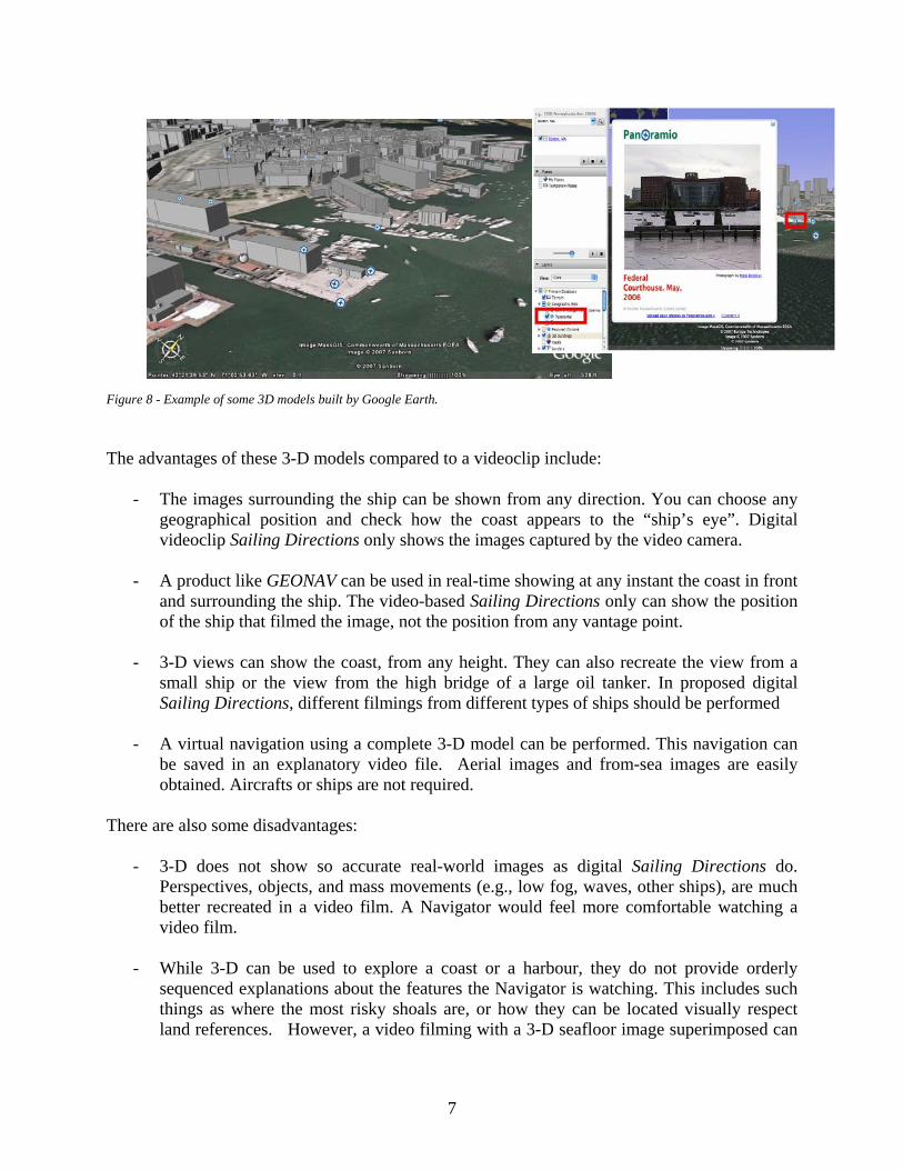
Figure 8 - Example of some 3D models built by Google Earth. The advantages of these 3-D models compared to a videoclip include:
- The images surrounding the ship can be shown from any direction. You can choose any geographical position and check how the coast appears to the “ship’s eye”. Digital videoclip Sailing Directions only shows the images captured by the video camera.
- A product like GEONAV can be used in real-time showing at any instant the coast in front
and surrounding the ship. The video-based Sailing Directions only can show the position of the ship that filmed the image, not the position from any vantage point.
- 3-D views can show the coast, from any height. They can also recreate the view from a
small ship or the view from the high bridge of a large oil tanker. In proposed digital Sailing Directions, different filmings from different types of ships should be performed
- A virtual navigation using a complete 3-D model can be performed. This navigation can
be saved in an explanatory video file. Aerial images and from-sea images are easily obtained. Aircrafts or ships are not required.
There are also some disadvantages:
- 3-D does not show so accurate real-world images as digital Sailing Directions do. Perspectives, objects, and mass movements (e.g., low fog, waves, other ships), are much better recreated in a video film. A Navigator would feel more comfortable watching a video film.
- While 3-D can be used to explore a coast or a harbour, they do not provide orderly
sequenced explanations about the features the Navigator is watching. This includes such things as where the most risky shoals are, or how they can be located visually respect land references. However, a video filming with a 3-D seafloor image superimposed can
7
explain in few seconds the location of a risky shoal, and how to reference it with respect to known land features.
- 3-D images cannot provide detailed views and explanations of features like a crane
working, or a power outlet cable coupling use. Video Sailing Directions can be highly-detailed and at close range (i.e., on the pier).
- Updates would be harder to perform. For example, modelling a building that has been
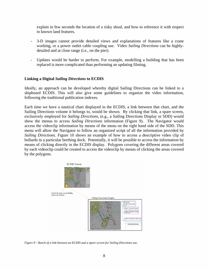
replaced is more complicated than performing an updating filming. Linking a Digital Sailing Directions to ECDIS Ideally, an approach can be developed whereby digital Sailing Directions can be linked to a shipboard ECDIS. This will also give some guidelines to organize the video information, following the traditional publication indexes. Each time we have a nautical chart displayed in the ECDIS, a link between that chart, and the Sailing Directions volume it belongs to, would be shown. By clicking that link, a spare screen, exclusively employed for Sailing Directions, (e.g., a Sailing Directions Display or SDD) would show the menus to access Sailing Directions information (Figure 9). The Navigator would access the videoclip information by means of the menu on the right hand side of the SDD. This menu will allow the Navigator to follow an organized script of all the information provided by Sailing Directions. Figure 10 shows an example of how to access a descriptive video clip of bollards in a particular berthing dock. Potentially, it will be possible to access the information by means of clicking directly in the ECDIS display. Polygons covering the different areas covered by each videoclip could be created to access the videoclip by means of clicking the areas covered by the polygons.
Figure 9 - Sketch of a link between an ECDIS and a spare screen for Sailing Directions use.
8
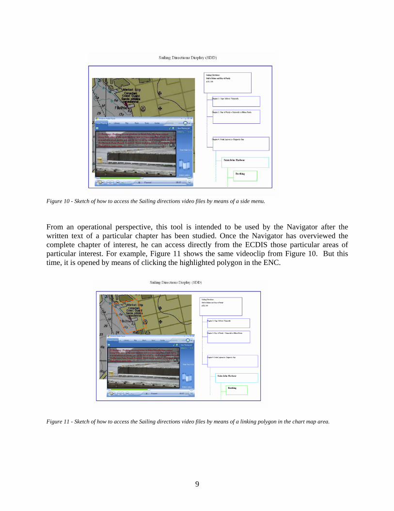
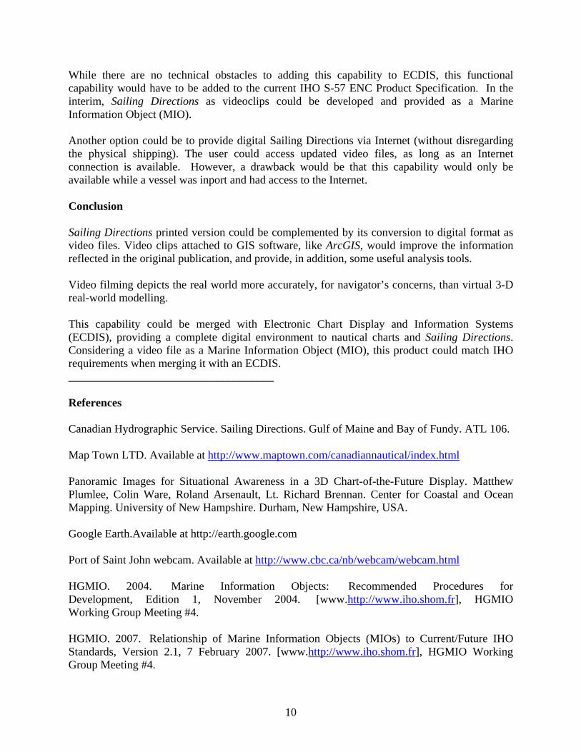
Figure 10 - Sketch of how to access the Sailing directions video files by means of a side menu. From an operational perspective, this tool is intended to be used by the Navigator after the written text of a particular chapter has been studied. Once the Navigator has overviewed the complete chapter of interest, he can access directly from the ECDIS those particular areas of particular interest. For example, Figure 11 shows the same videoclip from Figure 10. But this time, it is opened by means of clicking the highlighted polygon in the ENC. Figure 11 - Sketch of how to access the Sailing directions video files by means of a linking polygon in the chart map area.
9
While there are no technical obstacles to adding this capability to ECDIS, this functional capability would have to be added to the current IHO S-57 ENC Product Specification. In the interim, Sailing Directions as videoclips could be developed and provided as a Marine Information Object (MIO). Another option could be to provide digital Sailing Directions via Internet (without disregarding the physical shipping). The user could access updated video files, as long as an Internet connection is available. However, a drawback would be that this capability would only be available while a vessel was inport and had access to the Internet. Conclusion Sailing Directions printed version could be complemented by its conversion to digital format as video files. Video clips attached to GIS software, like ArcGIS, would improve the information reflected in the original publication, and provide, in addition, some useful analysis tools. Video filming depicts the real world more accurately, for navigator’s concerns, than virtual 3-D real-world modelling. This capability could be merged with Electronic Chart Display and Information Systems (ECDIS), providing a complete digital environment to nautical charts and Sailing Directions. Considering a video file as a Marine Information Object (MIO), this product could match IHO requirements when merging it with an ECDIS. ____________________________________ References Canadian Hydrographic Service. Sailing Directions. Gulf of Maine and Bay of Fundy. ATL 106. Map Town LTD. Available at http://www.maptown.com/canadiannautical/index.html Panoramic Images for Situational Awareness in a 3D Chart-of-the-Future Display. Matthew Plumlee, Colin Ware, Roland Arsenault, Lt. Richard Brennan. Center for Coastal and Ocean Mapping. University of New Hampshire. Durham, New Hampshire, USA. Google Earth.Available at http://earth.google.com Port of Saint John webcam. Available at http://www.cbc.ca/nb/webcam/webcam.html HGMIO. 2004. Marine Information Objects: Recommended Procedures for Development, Edition 1, November 2004. [www.http://www.iho.shom.fr], HGMIO Working Group Meeting #4. HGMIO. 2007. Relationship of Marine Information Objects (MIOs) to Current/Future IHO Standards, Version 2.1, 7 February 2007. [www.http://www.iho.shom.fr], HGMIO Working Group Meeting #4.
10


![[45/15] UPDATES TO ADMIRALTY SAILING DIRECTIONS](https://img.pdfslide.net/doc/110x75/6204f032d1e77e7ed0289469/4515-updates-to-admiralty-sailing-directions.jpg)