Embed Size (px)
Citation preview

Satellite Based ADS-BNAV CANADADecember 2013

Outline• Aireon Global ADS-B via LEO
satellites• Why the initial focus
on the North Atlantic?• Benefits Assessment• Work Underway and Moving
Forward

GoalTo reduce aircraft separation minima through ADS-B (out) via global Low Earth Orbiting (LEO) satellites

Aireon ADS-B via Low Earth Orbiting (LEO) Satellites


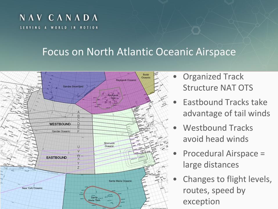
• Organized Track Structure NAT OTS
• Eastbound Tracks take advantage of tail winds
• Westbound Tracks avoid head winds
• Procedural Airspace = large distances
• Changes to flight levels, routes, speed by exception
Focus on North Atlantic Oceanic Airspace

Gander/Shanwick Airspace Today• 1,000 flights per day
(1,300 peak summer day)
• 350,000 commercial flights per year
• +23,000 military & GA flights per year
• 88% of the flights are already ADS-B equipped
• 74% of flights are Data Link (FANS 1/A) equipped
• 75% are capable and use Controller Pilot Data Link Communications (CPDLC)

Current NAT OperationsWithout ADS-B
Current NAT OperationsWith Ground Based ADS-B

Benefits Assessment

Aireon ADS-B System BenefitsSafety• ADS-B provides real time aircraft surveillance• Improves situational awareness, conflict detection and
reaction/resolution • Aircraft would have more flexibility in emergency situations• Provides surveillance source separate from the
communications (CPDLC) network sources • More complete and accurate reporting of aviation
occurrences, allowing better management of safety risk and better support of the Safety Management System
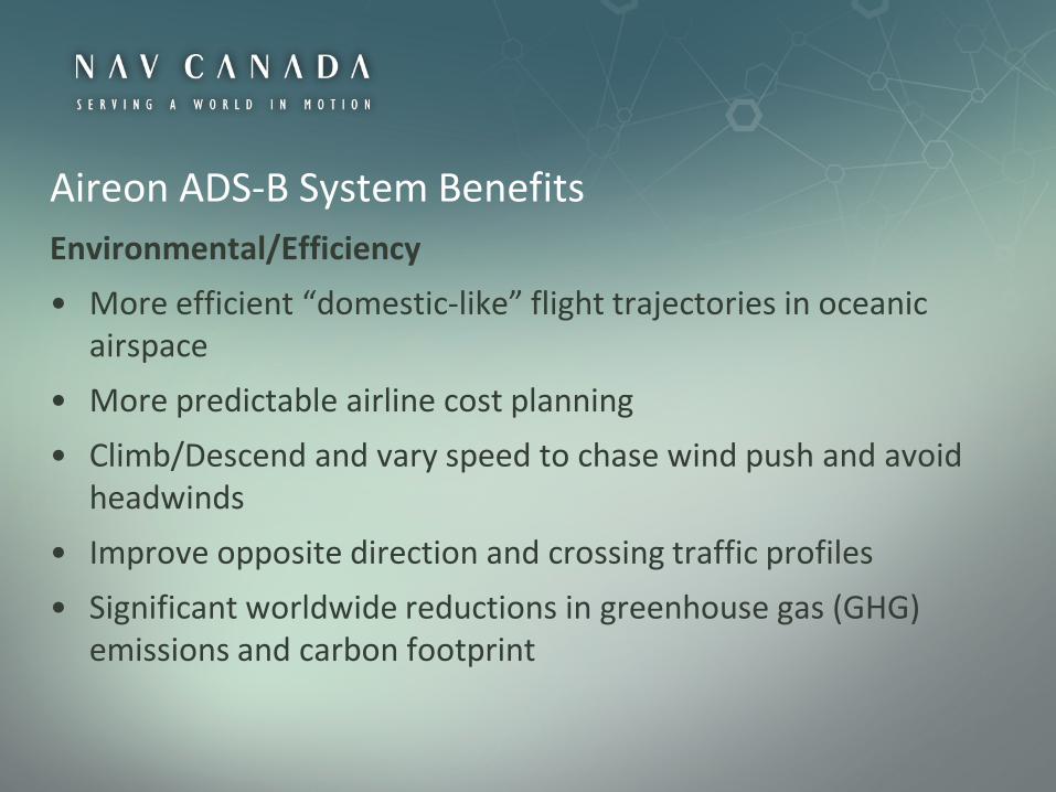
Aireon ADS-B System BenefitsEnvironmental/Efficiency• More efficient “domestic-like” flight trajectories in oceanic
airspace• More predictable airline cost planning• Climb/Descend and vary speed to chase wind push and avoid
headwinds• Improve opposite direction and crossing traffic profiles• Significant worldwide reductions in greenhouse gas (GHG)
emissions and carbon footprint
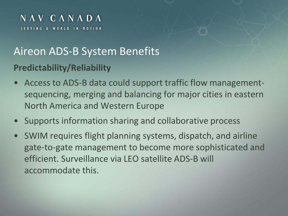
Aireon ADS-B System BenefitsPredictability/Reliability• Access to ADS-B data could support traffic flow management-
sequencing, merging and balancing for major cities in eastern North America and Western Europe
• Supports information sharing and collaborative process• SWIM requires flight planning systems, dispatch, and airline
gate-to-gate management to become more sophisticated and efficient. Surveillance via LEO satellite ADS-B will accommodate this.

Traffic to/from NAT Tracks within Europe

Overview of Traffic on Tracks and No Tracks

LEO ADS-B Benefits Assessment
Determine the 2018 (1st year) fuel burn:• Base Case with RLongSM &
RLatSM. • ADS-B Case: 15nm longitudinal
and 30 nm lateral separation.• Compare the Base Case
and ADS-B fuel results.• Determine the net
fuel savings per flight.

LEOS ADS-B Benefits AssessmentApproach and Assumptions• The Total Airspace and Airport Modeller (TAAM)–fast time
simulation tool was used to calculate fuel based on– June 2012 NAT traffic – Wind forecasts from the National Oceanic and Atmospheric
Administration (NOAA)
• 2018: all aircraft Data Link capable and 90% ADS-B• 2018: aircraft mix adjusted to retire B747-400s, replace some B767s
with 787s• Fuel computed for Oceanic airspace only, although benefits could
accrue beyond

Annual Gander/Shanwick Benefits
• A conservative estimate of fuel savings of 450 litres per NAT flight. Over 600 flights were simulated.
• Consistent with IATA members’ savings from the variable speed/Flight Level ENGAGE project
• Represents less than 2% of the ocean portion of fuel per flight (450/26,000 litres)
• Year one benefits estimated at $127 m for 2018

Global Oceanic ADS-B Benefits

Initial Oceanic Assessment• High level assessment of 7
additional areas• Based on 1,000’ climb fuel savings • Up to 3 climbs per flight
• Vetted with IATA airline member familiar with oceanic operations
• Considered conservative and achievable

Oceanic Assessment BenefitsEstimated $439 million in 2018
Major Oceanic FIRsCommercial
IFR Flights (000s)Total Fuel Climb Savings (000s)
GHGs (000s Tonnes CO2
Equiv)
Pacific 131 $169,776 446.4
Shanwick / Gander 390 $127,000 332.8
New York-Santa Maria 138 $64,584 169.8
US Coastal 109 $7,358 19.3
Tasman Sea 48 $3,240 8.5
Mumbai 22 $1,337 3.5
North Atlantic above 65º 46 $21,528 56.6
South Pacific 20 $43,920 115.5
904 $438,742 1,152.4

Work Underway and Moving Forward

Payload being developed by Harris Corporation• Harris selected to build 81 space-qualified ADS-B receivers in June 2012• 50+ years designing and manufacturing space hardware and major FAA contractor
• Design phase complete; production starting; first unit delivery Feb 2014
Hosted Payload Operations Center be supported by Iridium• Developed by an Iridium/Boeing team in Virginia
and Arizona
Systems engineering and ground data processing system by Exelis• Exelis has significant expertise and existing infrastructure
supporting the FAA ADS-B terrestrial system deployment• Successful Preliminary Design Review completed in Sep 2013
On-track to meet first launch in early 2015 Initial Operations Capability 2018

Harris ADS-B Payload Development On Target • Harris ADS-B Payload Development On Target • Harris ADS-B Payload CDR successfully completed in May, 2013 • Payload also completed the Test Readiness and Production
Readiness reviews in October 2013 • Payload Qualification Unit is being tested in a dedicated
production facility at Harris • Testing is expected to be complete by Feb 2014 when it will be
shipped to Thales Alenia Space in France for further integration and testing with the satellite

Hosted Payload
Inverted Hosted Payload

Global Coverage – 250 W
Global Coverage – 250 W
• Nominal coverage for 250 W aircraft
• North-South footprint spacing approx. 1970 NM or 9 minutes
• Cone of silence is smaller– not depicted
in video(Video @ 60x actual speed)

Global Coverage – 125 W
• Nominal coverage for 125 W aircraft
• North-South footprint spacing approx. 1970 NM or 9 minutes
(Video @ 300x actual speed)

Coverage• Avionics standards identify classes of
airborne transmitters with power outputs of 125 Watts, 250 Watts and 500 Watts
• Modelled coverage limitations are primarily associated with 125 Watt aircraft transmitters
• Gaps in predicted coverage are associated with:– Cone of Silence – caused by aircraft
antenna– Imperfect overlap of adjacent satellite
coverage patterns– FRUIT – Interference from other
ground-based and airborne transmitters

Cone of Silence
• Analysis of gaps caused by cone of silence andother sources was performed for a 125Wtransponder, and a TLAT aircraft antenna patternas shown below
• Gaps are relatively short, maximum of 35 seconds,for a 125W aircraft.
• Currently such gaps caused by Cone of Silenceresults in the temporary loss of 1 or 2 updates at15 sec update rate comparable to radar coasting
• For oceanic flights, percentage of time Aireonwould meet 15 sec update is well over 95% evenwith Cone of Silence Cone of Silence moving through
Gander FIR

IATA • Engagement with IATA OPC Committee commenced in 2012
and continue by-annually• Regular briefings/collaboration with regional coordination
group ongoing• First Space Based ADS-B Advisory Committee (SAAC) meeting
held October 14 in Singapore.
“Safety is aviation’s top priority. The advancement of a global, space-based surveillance system is a new industry work area with the potential to enhance safety and efficiency for service providers and airspace users in many areas of the world,” Guenther Matschnigg, IATA Senior Vice President, Safety and Flight Operations

ICAO• Air Navigation Conference Recommendation 1/9• NAT SPG presentation• ICAO 38th Assembly• EANPG presentation• Working with International Telecommunications Union WG for
World Radio communications Conference (WRC-15) amendment to ITU Radio Regulations to ensure frequency spectrum protection
• Demonstration activities commencing from 2015 onward

North Atlantic Systems Planning GroupNAT SPG
NAT SOG NAT EFG NAT IMG
NAT ATMG NAT CNSG NAT SARSIG
NAM EANPG
MIDCAR

Actions Going Forward
• Continue to collaborate with ANSPs, IATA/industry and ICAO/regulator to demonstrate and validate incremental improvements.
• Leverage existing technology and continue to improve service, e.g., RLongSM and RLatSM.
• Operational trials involving airlines/ANSPs will be used to demonstrate capabilities and support the safety case

In Advance of Satellite Based ADS-B• RlongSM implemented in Gander and Shanwick OCAs March
21, 2011• Prepping for RLatSM - Phase 1 2015, Phases 2 and 3 TBD• Publishing Gander Oceanic Transition Area (GOTA) April 2014
and expanding use of ground-based ADS-B in Oceanic airspace• Ground based ADS-B corridor Scotland to Greenland 2014-
2015• Mid-Late 2016: implementation of conformance monitoring
using available space-based ADS-B data

Application in the NAT: Principles
• Initially, no change to the Organized Track System (OTS) or Oceanic Clearances
• Initial application on core tracks in same direction only
• Use a phased approach - similar to DATALINK
• Apply priority handling (best equipped best served)

Operational Validation
• data collection on ADS-B and communications
• collaboration with NATS and FAA on final CONOPS
• GAATS+ deployment in Prestwick

Initial Application in the NAT
• Late 2017: application of 15 NM longitudinal separation (with RLatSM) between surveillance-identified aircraft operating on the NAT OTS.
• Early 2018: 15 NM longitudinal separation expanded to aircraft operating off the NAT OTS.

Future Procedure Changes in the NAT
• Mid 2018: allowing surveillance identified aircraft to operate on all tracks which do not intersect (still RLatSM).
• Late 2018: use of ATS surveillance to maintain 15 NM lateral separation between the tracks of surveillance-identified aircraft operating on non-intersecting tracks;
• Early 2019: application of 15 NM separation between surveillance-identified aircraft

In summary• Global ADS-B Surveillance is a “Game Changer” for aviation• Fits with NEXT GEN / SESAR• Significant fuel & GHG savings • Avoids ADS-B ground based replacement or some initial
installation costs • Benefits to domestic traffic can be realized in remote areas or
through improved air traffic flow management to and from oceanic
• Public will benefit from safer + more expeditious flights in remote, polar and oceanic airspace worldwide
• Opportunity to boost aviation innovation & the environment globally

Questions?