Embed Size (px)
Citation preview
New Precipitation products (GPM, GCOM-W)
and more
Misako KACHI Earth Observation Research Center (EORC) Japan Aerospace Exploration Agency (JAXA)
19 Nov. 2014, IPWG Training Course
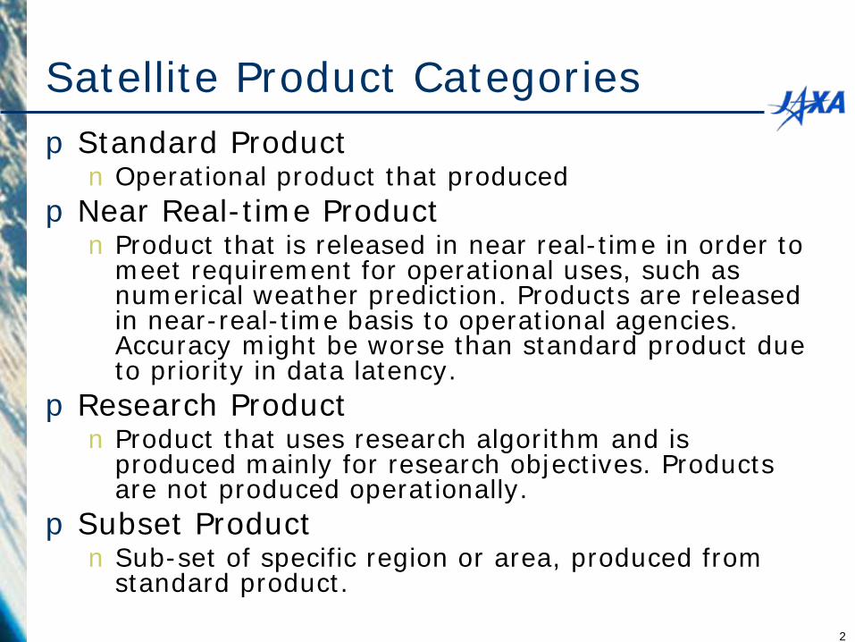
Satellite Product Categories pStandard Product n Operational product that produced
pNear Real-time Product n Product that is released in near real-time in order to
meet requirement for operational uses, such as numerical weather prediction. Products are released in near-real-time basis to operational agencies. Accuracy might be worse than standard product due to priority in data latency.
pResearch Product n Product that uses research algorithm and is
produced mainly for research objectives. Products are not produced operationally.
pSubset Product n Sub-set of specific region or area, produced from
standard product.
2
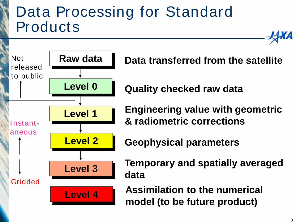
Data transferred from the satellite
Quality checked raw data
Temporary and spatially averaged data
Geophysical parameters
Raw data
Level 0
Level 1
Level 2
Level 3
Data Processing for Standard Products
Instant- aneous
Gridded
Level 4
Engineering value with geometric & radiometric corrections
Assimilation to the numerical model (to be future product)
Not released to public
3
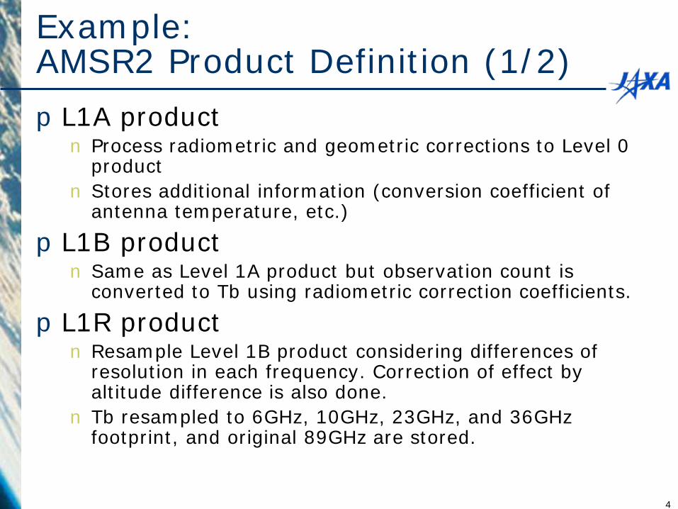
Example: AMSR2 Product Definition (1/2) pL1A product n Process radiometric and geometric corrections to Level 0
product n Stores additional information (conversion coefficient of
antenna temperature, etc.)
pL1B product n Same as Level 1A product but observation count is
converted to Tb using radiometric correction coefficients.
pL1R product n Resample Level 1B product considering differences of
resolution in each frequency. Correction of effect by altitude difference is also done.
n Tb resampled to 6GHz, 10GHz, 23GHz, and 36GHz footprint, and original 89GHz are stored.
4
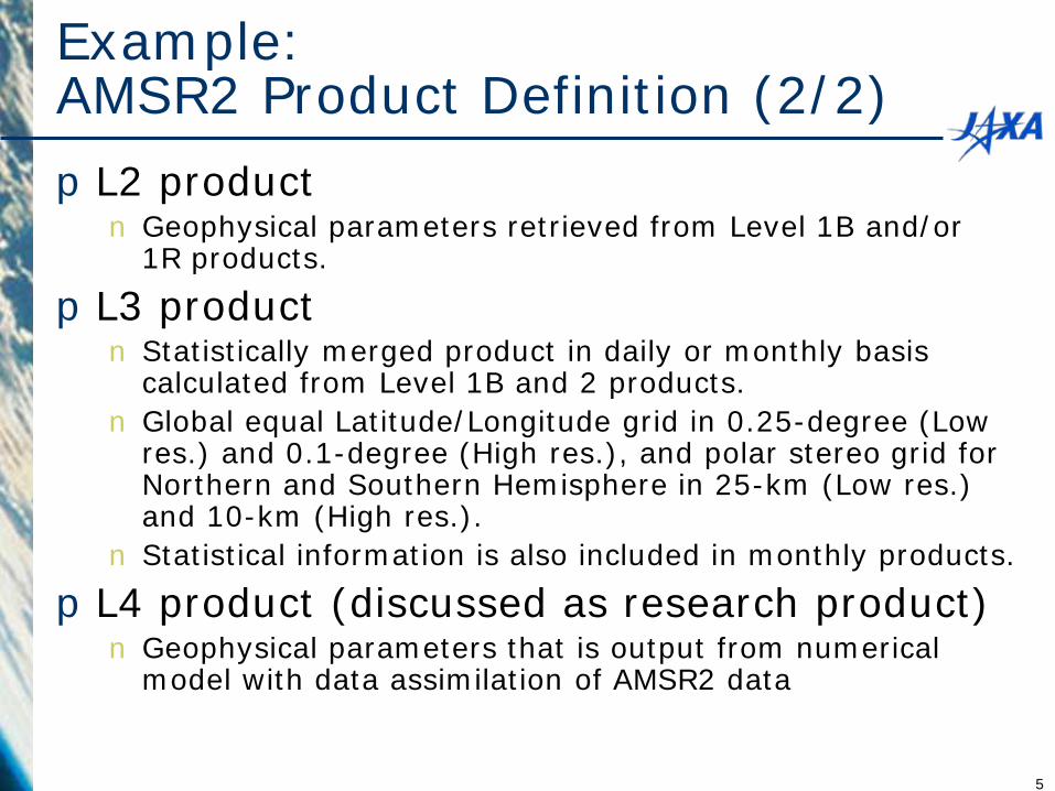
Example: AMSR2 Product Definition (2/2) pL2 product n Geophysical parameters retrieved from Level 1B and/or
1R products.
pL3 product n Statistically merged product in daily or monthly basis
calculated from Level 1B and 2 products. n Global equal Latitude/Longitude grid in 0.25-degree (Low
res.) and 0.1-degree (High res.), and polar stereo grid for Northern and Southern Hemisphere in 25-km (Low res.) and 10-km (High res.).
n Statistical information is also included in monthly products.
pL4 product (discussed as research product) n Geophysical parameters that is output from numerical
model with data assimilation of AMSR2 data
5
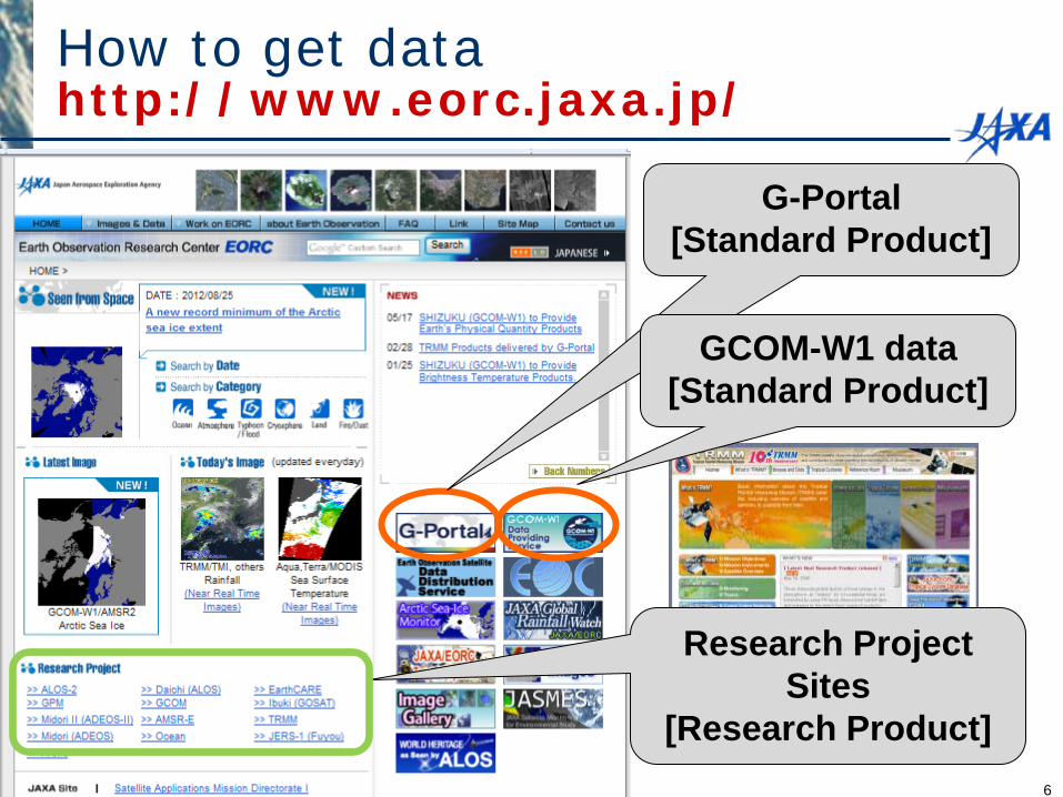
How to get data http://www.eorc.jaxa.jp/
G-Portal [Standard Product]
Research Project Sites
[Research Product]
GCOM-W1 data [Standard Product]
6
TRMM/GPM/AMSR-E/AMSR2 data/image access -
Images, Research Products
7
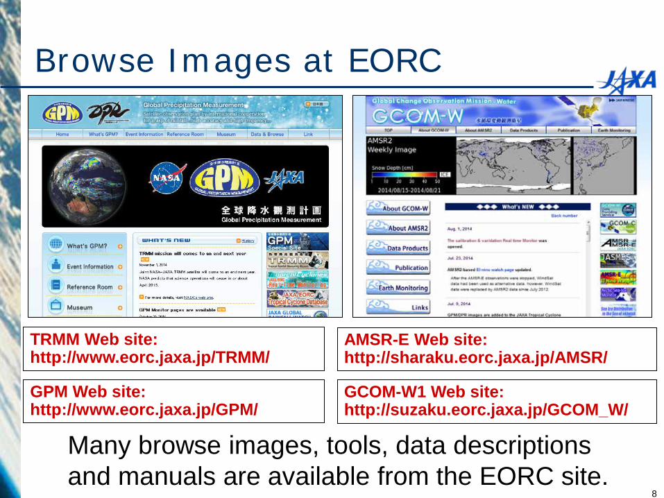
Browse Images at EORC
TRMM Web site: http://www.eorc.jaxa.jp/TRMM/
AMSR-E Web site: http://sharaku.eorc.jaxa.jp/AMSR/
Many browse images, tools, data descriptions and manuals are available from the EORC site.
GCOM-W1 Web site: http://suzaku.eorc.jaxa.jp/GCOM_W/
GPM Web site: http://www.eorc.jaxa.jp/GPM/
8
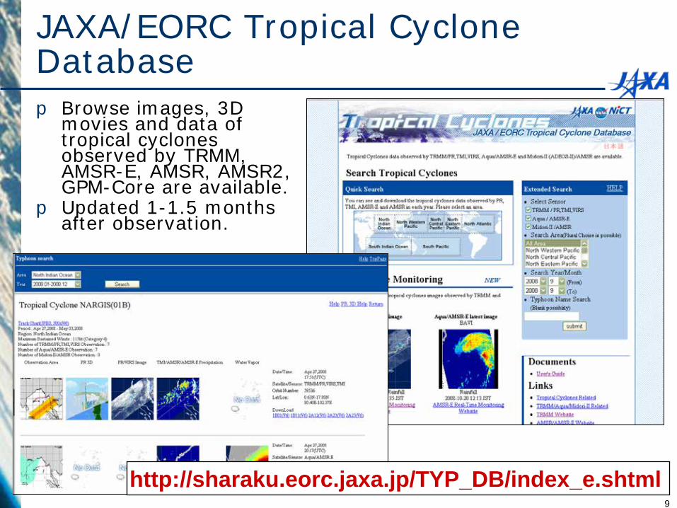
JAXA/EORC Tropical Cyclone Database p Browse images, 3D
movies and data of tropical cyclones observed by TRMM, AMSR-E, AMSR, AMSR2, GPM-Core are available.
p Updated 1-1.5 months after observation.
http://sharaku.eorc.jaxa.jp/TYP_DB/index_e.shtml 9
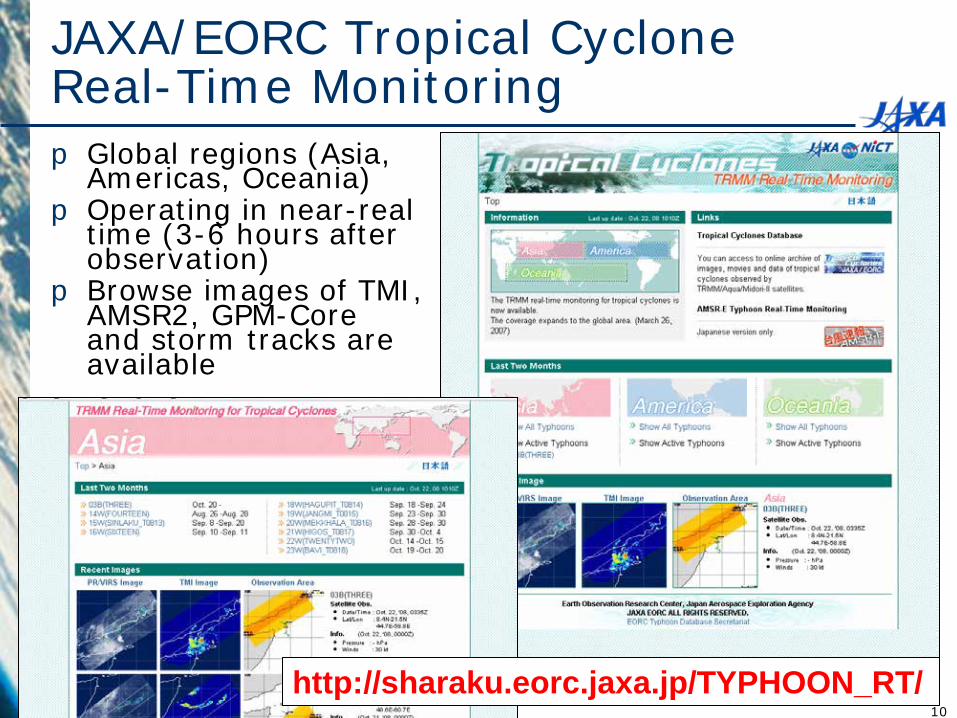
JAXA/EORC Tropical Cyclone Real-Time Monitoring p Global regions (Asia,
Americas, Oceania) p Operating in near-real
time (3-6 hours after observation)
p Browse images of TMI, AMSR2, GPM-Core and storm tracks are available
http://sharaku.eorc.jaxa.jp/TYPHOON_RT/ 10
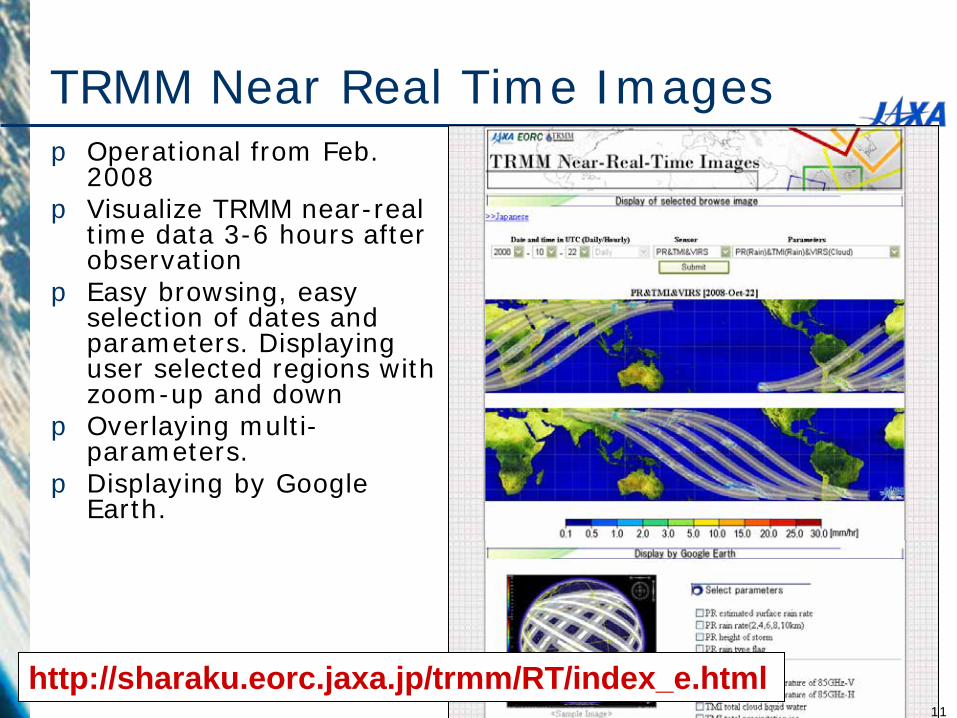
TRMM Near Real Time Images p Operational from Feb.
2008 p Visualize TRMM near-real
time data 3-6 hours after observation
p Easy browsing, easy selection of dates and parameters. Displaying user selected regions with zoom-up and down
p Overlaying multi-parameters.
p Displaying by Google Earth.
http://sharaku.eorc.jaxa.jp/trmm/RT/index_e.html 11
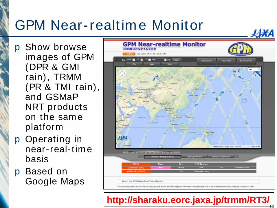
GPM Near-realtime Monitor p Show browse
images of GPM (DPR & GMI rain), TRMM (PR & TMI rain), and GSMaP NRT products on the same platform
pOperating in near-real-time basis
p Based on Google Maps http://sharaku.eorc.jaxa.jp/trmm/RT3/
12
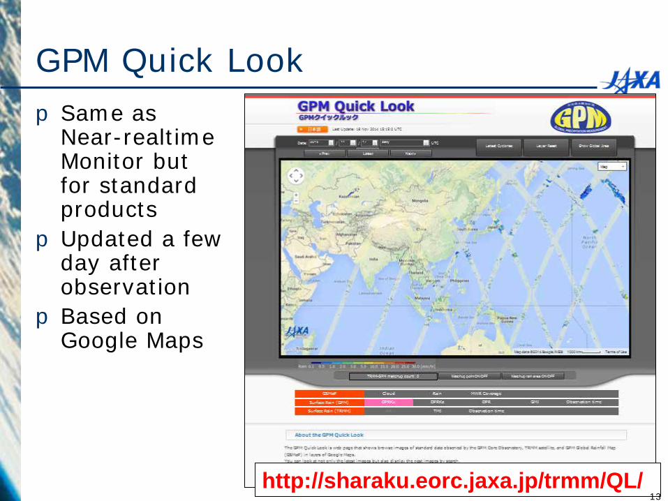
GPM Quick Look p Same as
Near-realtime Monitor but for standard products
p Updated a few day after observation
p Based on Google Maps
http://sharaku.eorc.jaxa.jp/trmm/QL/ 13
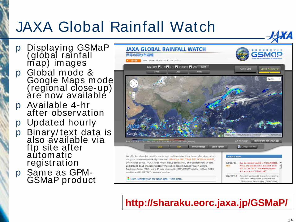
JAXA Global Rainfall Watch p Displaying GSMaP
(global rainfall map) images
p Global mode & Google Maps mode (regional close-up) are now available
p Available 4-hr after observation
p Updated hourly p Binary/text data is
also available via ftp site after automatic registration
p Same as GPM-GSMaP product
http://sharaku.eorc.jaxa.jp/GSMaP/ 14
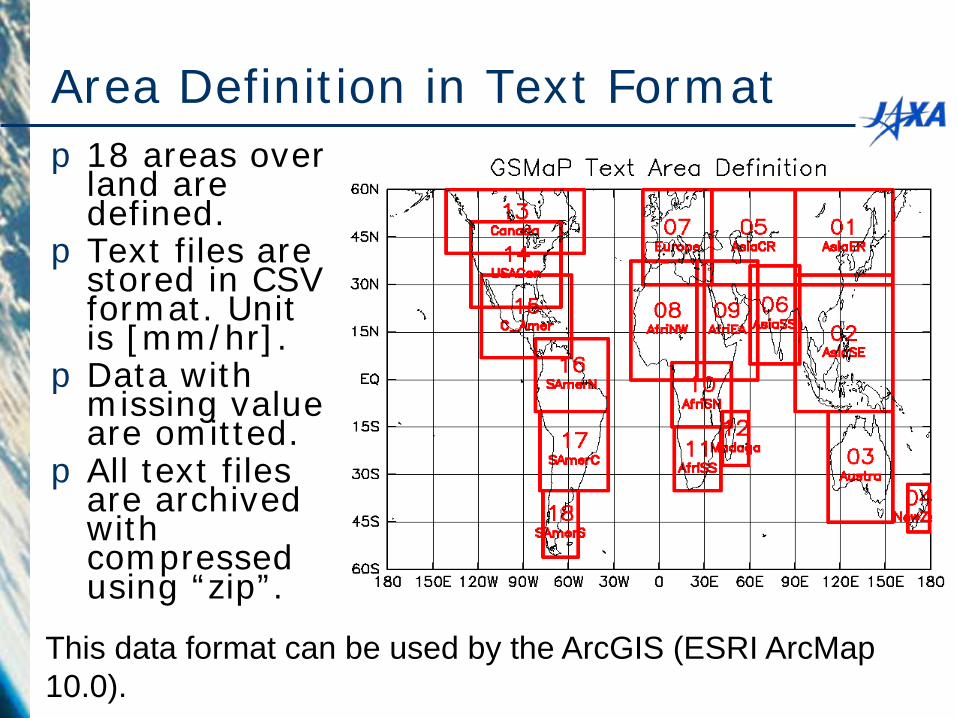
Area Definition in Text Format p18 areas over
land are defined.
pText files are stored in CSV format. Unit is [mm/hr].
pData with missing value are omitted.
pAll text files are archived with compressed using “zip”.
This data format can be used by the ArcGIS (ESRI ArcMap 10.0).
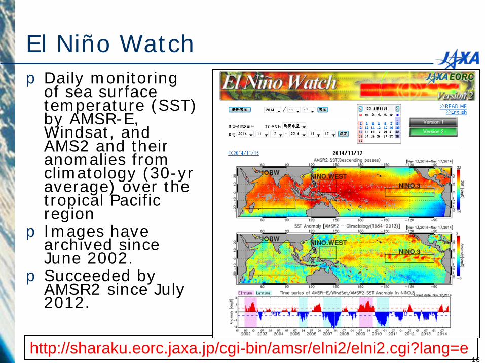
El Niño Watch p Daily monitoring
of sea surface temperature (SST) by AMSR-E, Windsat, and AMS2 and their anomalies from climatology (30-yr average) over the tropical Pacific region
p Images have archived since June 2002.
p Succeeded by AMSR2 since July 2012.
http://sharaku.eorc.jaxa.jp/cgi-bin/amsr/elni2/elni2.cgi?lang=e 16
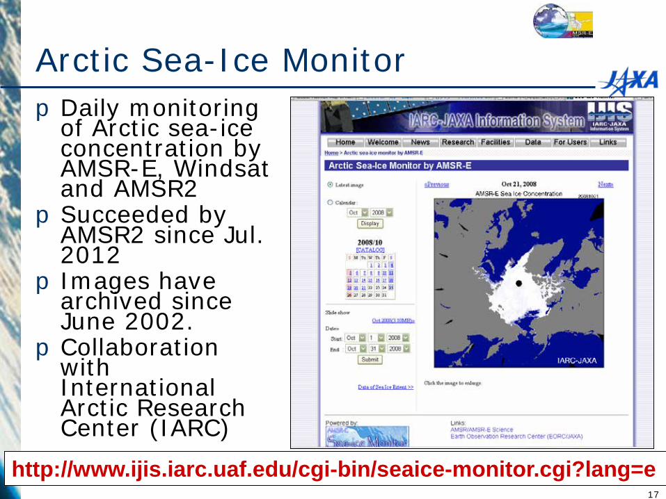
Arctic Sea-Ice Monitor pDaily monitoring
of Arctic sea-ice concentration by AMSR-E, Windsat and AMSR2
pSucceeded by AMSR2 since Jul. 2012
p Images have archived since June 2002.
pCollaboration with International Arctic Research Center (IARC)
http://www.ijis.iarc.uaf.edu/cgi-bin/seaice-monitor.cgi?lang=e 17
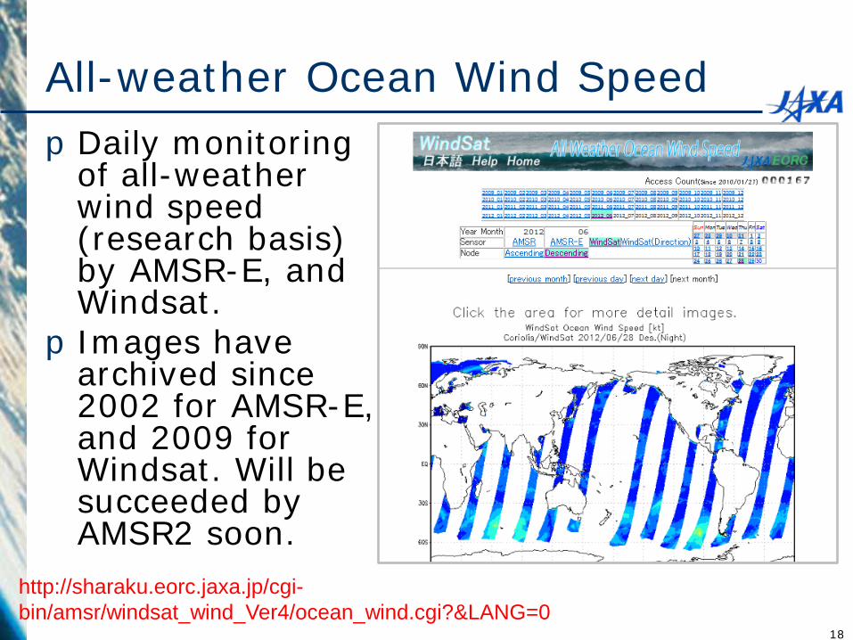
All-weather Ocean Wind Speed pDaily monitoring
of all-weather wind speed (research basis) by AMSR-E, and Windsat. pImages have
archived since 2002 for AMSR-E, and 2009 for Windsat. Will be succeeded by AMSR2 soon.
http://sharaku.eorc.jaxa.jp/cgi-bin/amsr/windsat_wind_Ver4/ocean_wind.cgi?&LANG=0
18
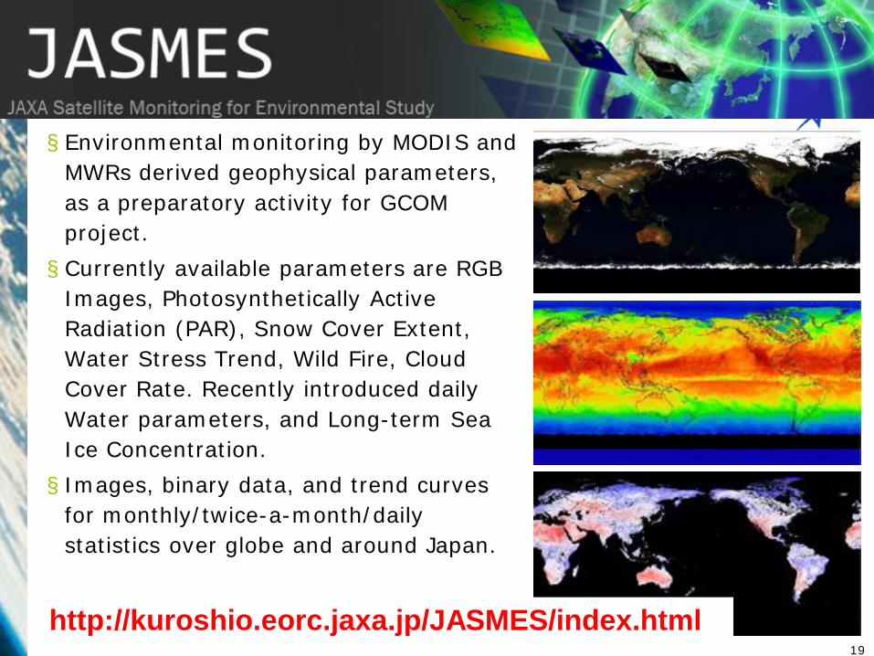
§ Environmental monitoring by MODIS and MWRs derived geophysical parameters, as a preparatory activity for GCOM project. § Currently available parameters are RGB
Images, Photosynthetically Active Radiation (PAR), Snow Cover Extent, Water Stress Trend, Wild Fire, Cloud Cover Rate. Recently introduced daily Water parameters, and Long-term Sea Ice Concentration. § Images, binary data, and trend curves
for monthly/twice-a-month/daily statistics over globe and around Japan.
http://kuroshio.eorc.jaxa.jp/JASMES/index.html 19
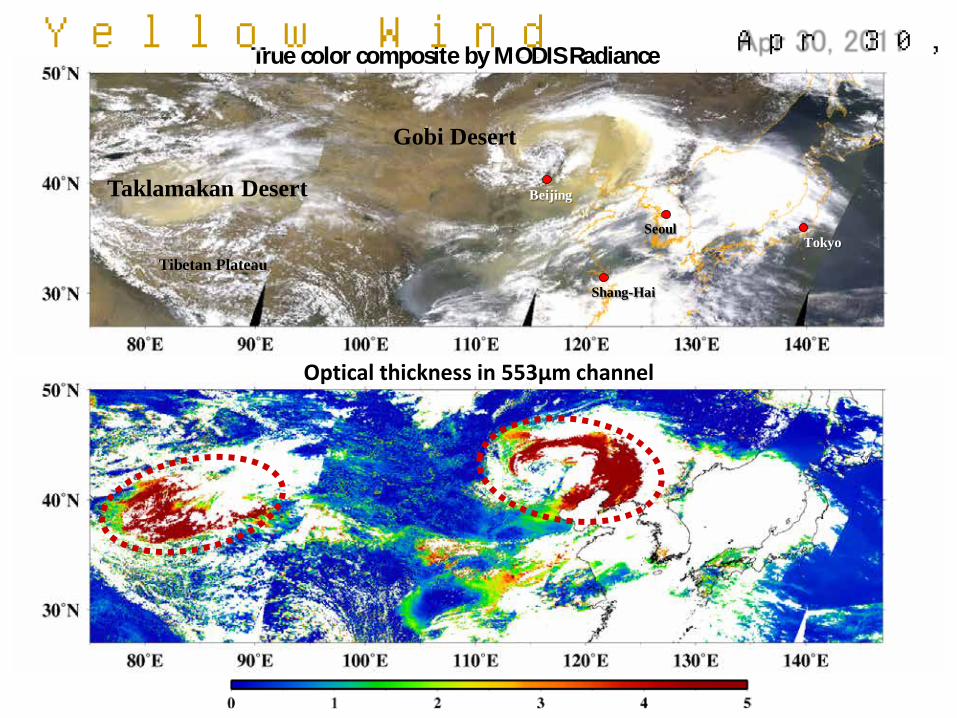
True color composite by MODIS Radiance
Taklamakan Desert
Gobi Desert
Tokyo
Beijing
Tibetan Plateau
Shang-Hai
Seoul
Apr 30, 2011
Optical thickness in 553μm channel
Yellow Wind
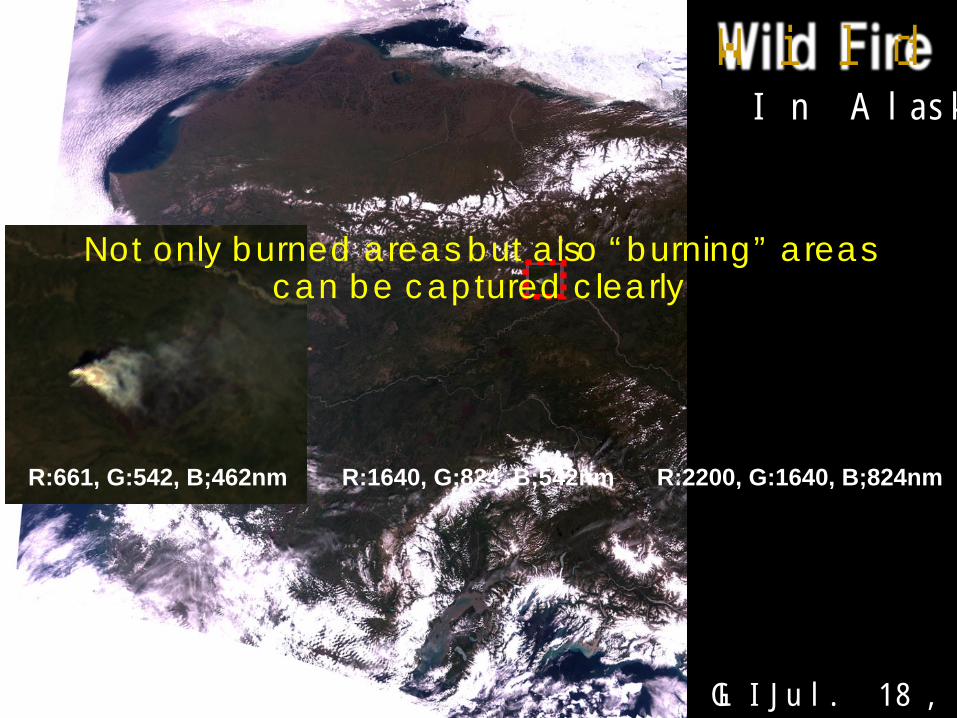
Wild Fire In Alaska
GLI Jul. 18, 2003
R:661, G:542, B;462nm R:1640, G:824, B;542nm R:2200, G:1640, B;824nm
Not only burned areas but also “burning” areas can be captured clearly
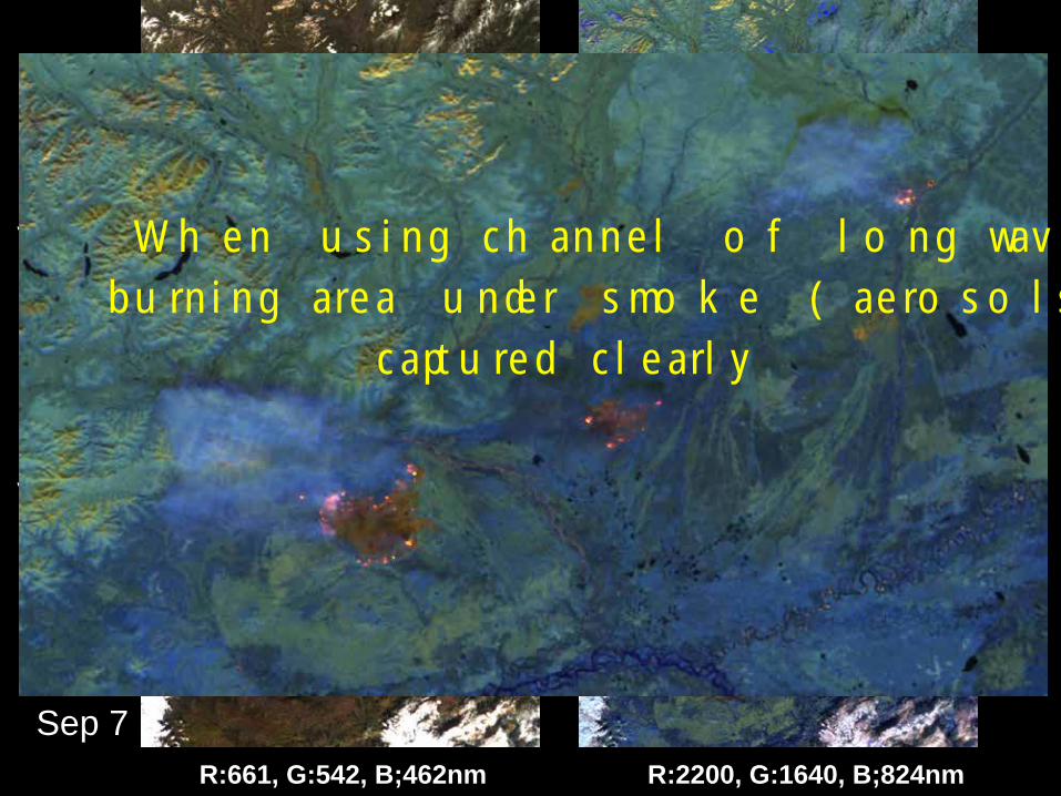
July 18
R:661, G:542, B;462nm R:2200, G:1640, B;824nm
Sep 7
July 20
When using channel of long wavelength, burning area under smoke (aerosols) can be
captured clearly
AMSR2 Browse Web Site (JASMES for water cycle) pMonitoring daily browse images of AMSR2
standard products (TB and GEO) pUpdating near-real-time basis (using NRT
swath data) and daily (using L3 standard products) pOperating as daily version of JASMES web site pScaling up/down, select region, comparison of
parameters and/or instruments pBrowse images of test products, which applies
AMSR2 algorithm to other MWR instruments (AMSR-E, TMI, Windsat, SSM/I etc.,) are also available.
http://kuroshio.eorc.jaxa.jp/JASMES/WC.html 23
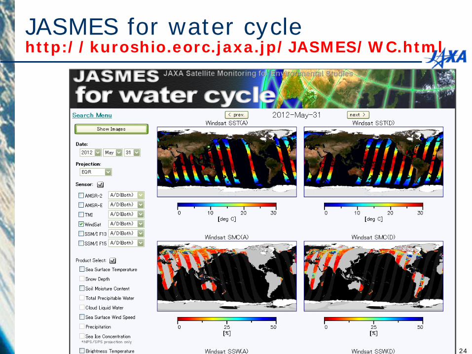
JASMES for water cycle http://kuroshio.eorc.jaxa.jp/JASMES/WC.html
24
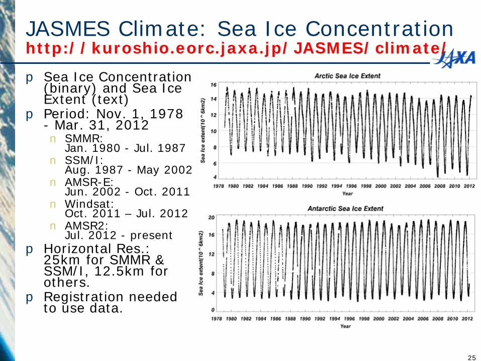
JASMES Climate: Sea Ice Concentration http://kuroshio.eorc.jaxa.jp/JASMES/climate/
p Sea Ice Concentration (binary) and Sea Ice Extent (text)
p Period: Nov. 1, 1978 - Mar. 31, 2012 n SMMR:
Jan. 1980 - Jul. 1987 n SSM/I:
Aug. 1987 - May 2002 n AMSR-E:
Jun. 2002 - Oct. 2011 n Windsat:
Oct. 2011 – Jul. 2012 n AMSR2:
Jul. 2012 - present p Horizontal Res.:
25km for SMMR & SSM/I, 12.5km for others.
p Registration needed to use data.
25
TRMM/GPM/AMSR-E/AMSR2 data/image access -
Standard products
26
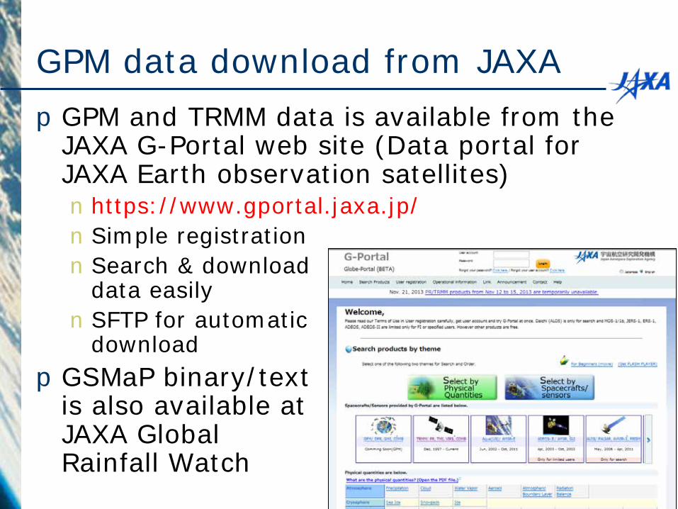
GPM data download from JAXA pGPM and TRMM data is available from the
JAXA G-Portal web site (Data portal for JAXA Earth observation satellites) n https://www.gportal.jaxa.jp/ nSimple registration nSearch & download
data easily nSFTP for automatic
download pGSMaP binary/text
is also available at JAXA Global Rainfall Watch
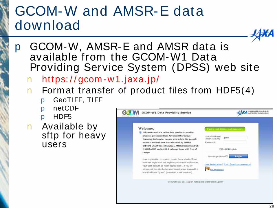
GCOM-W and AMSR-E data download p GCOM-W, AMSR-E and AMSR data is
available from the GCOM-W1 Data Providing Service System (DPSS) web site n https://gcom-w1.jaxa.jp/ n Format transfer of product files from HDF5(4) p GeoTIFF, TIFF p netCDF p HDF5
n Available by sftp for heavy users
28
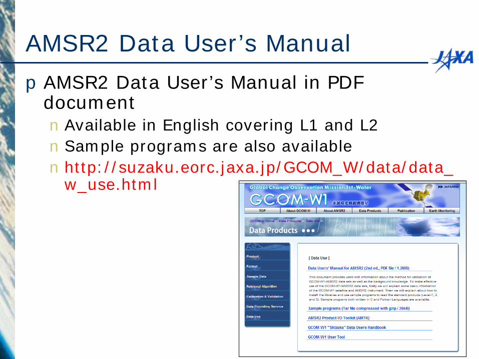
AMSR2 Data User’s Manual pAMSR2 Data User’s Manual in PDF
document nAvailable in English covering L1 and L2 nSample programs are also available n http://suzaku.eorc.jaxa.jp/GCOM_W/data/data_
w_use.html
30
How to read GPM data
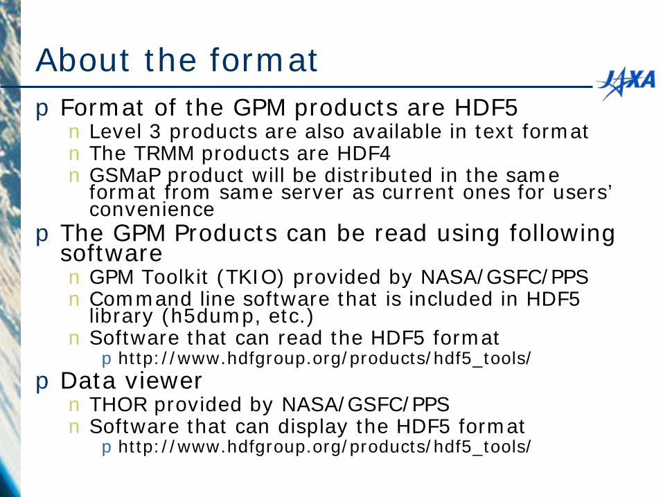
About the format pFormat of the GPM products are HDF5 n Level 3 products are also available in text format n The TRMM products are HDF4 n GSMaP product will be distributed in the same
format from same server as current ones for users’ convenience
pThe GPM Products can be read using following software n GPM Toolkit (TKIO) provided by NASA/GSFC/PPS n Command line software that is included in HDF5
library (h5dump, etc.) n Software that can read the HDF5 format phttp://www.hdfgroup.org/products/hdf5_tools/
pData viewer n THOR provided by NASA/GSFC/PPS n Software that can display the HDF5 format phttp://www.hdfgroup.org/products/hdf5_tools/
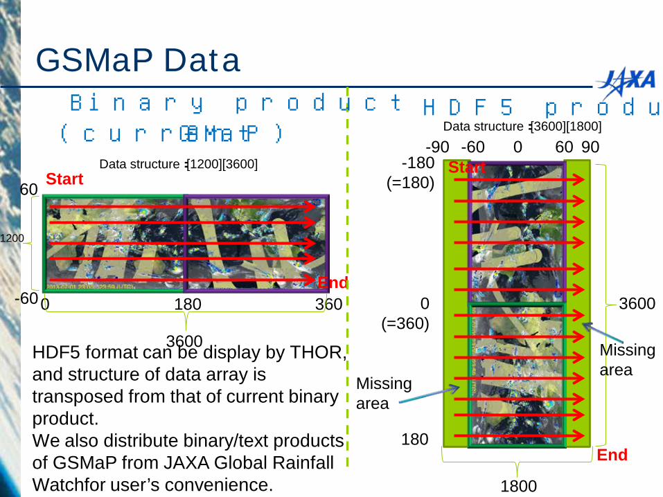
GSMaP Data
0 180 360
60
-60
60 -60 -180
(=180)
0 (=360)
180
90 -90 0 Start
End
Start
End
1800
1200
3600
3600
HDF5 product Binary product (current GSMaP)
HDF5 format can be display by THOR, and structure of data array is transposed from that of current binary product. We also distribute binary/text products of GSMaP from JAXA Global Rainfall Watchfor user’s convenience.
Data structure:[1200][3600]
Data structure:[3600][1800]
Missing area
Missing area
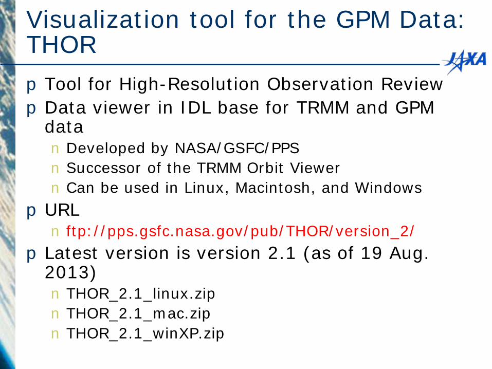
Visualization tool for the GPM Data: THOR pTool for High-Resolution Observation Review pData viewer in IDL base for TRMM and GPM
data n Developed by NASA/GSFC/PPS n Successor of the TRMM Orbit Viewer n Can be used in Linux, Macintosh, and Windows
pURL n ftp://pps.gsfc.nasa.gov/pub/THOR/version_2/
pLatest version is version 2.1 (as of 19 Aug. 2013) n THOR_2.1_linux.zip n THOR_2.1_mac.zip n THOR_2.1_winXP.zip
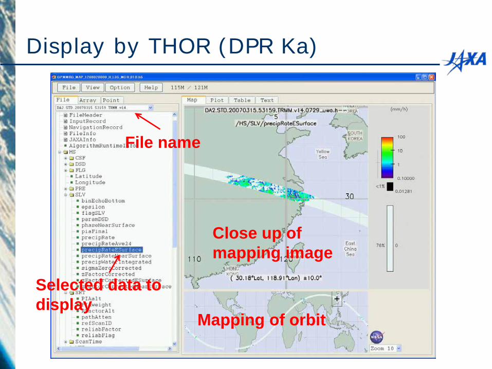
Display by THOR (DPR Ka)
Selected data to display
Mapping of orbit
Close up of mapping image
File name
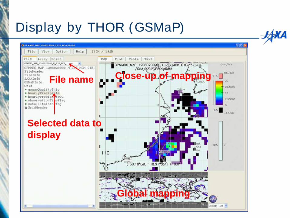
Display by THOR (GSMaP)
Selected data to display
Global mapping
Close-up of mapping File name
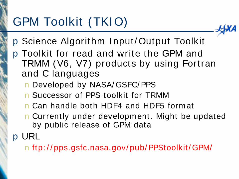
GPM Toolkit (TKIO) pScience Algorithm Input/Output Toolkit pToolkit for read and write the GPM and
TRMM (V6, V7) products by using Fortran and C languages nDeveloped by NASA/GSFC/PPS nSuccessor of PPS toolkit for TRMM nCan handle both HDF4 and HDF5 format nCurrently under development. Might be updated
by public release of GPM data pURL n ftp://pps.gsfc.nasa.gov/pub/PPStoolkit/GPM/
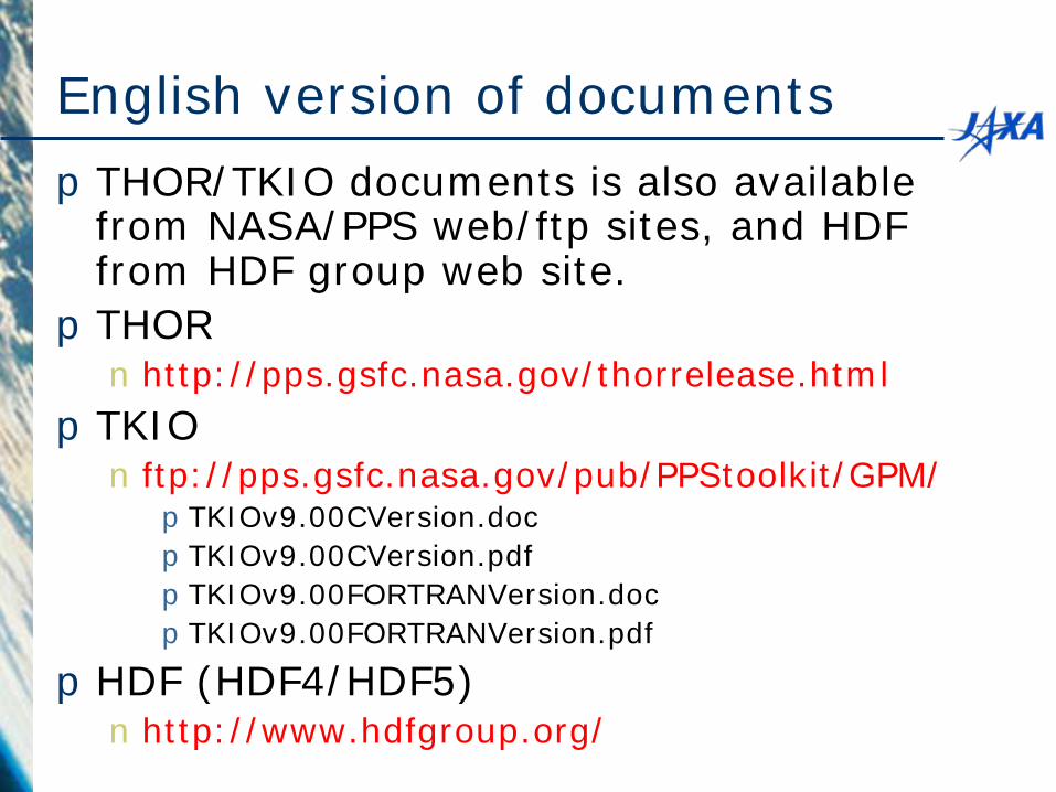
English version of documents pTHOR/TKIO documents is also available
from NASA/PPS web/ftp sites, and HDF from HDF group web site. pTHOR n http://pps.gsfc.nasa.gov/thorrelease.html
pTKIO n ftp://pps.gsfc.nasa.gov/pub/PPStoolkit/GPM/ pTKIOv9.00CVersion.doc pTKIOv9.00CVersion.pdf pTKIOv9.00FORTRANVersion.doc pTKIOv9.00FORTRANVersion.pdf
pHDF (HDF4/HDF5) n http://www.hdfgroup.org/
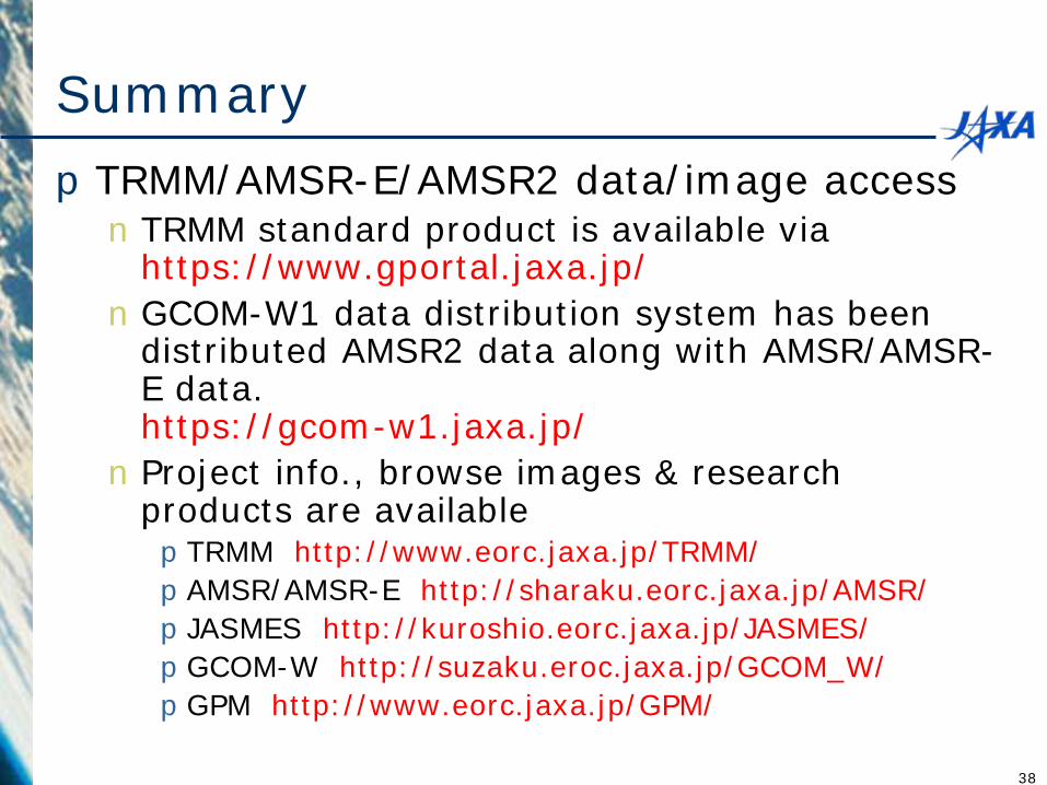
Summary pTRMM/AMSR-E/AMSR2 data/image access n TRMM standard product is available via
https://www.gportal.jaxa.jp/ nGCOM-W1 data distribution system has been
distributed AMSR2 data along with AMSR/AMSR-E data. https://gcom-w1.jaxa.jp/ n Project info., browse images & research
products are available pTRMM http://www.eorc.jaxa.jp/TRMM/ pAMSR/AMSR-E http://sharaku.eorc.jaxa.jp/AMSR/ pJASMES http://kuroshio.eorc.jaxa.jp/JASMES/ pGCOM-W http://suzaku.eroc.jaxa.jp/GCOM_W/ pGPM http://www.eorc.jaxa.jp/GPM/
38