Embed Size (px)
Citation preview
Grade 7 Program: The Earth’s Crust
“Our Lessons Really Rock!”
Scenic Caves Nature Adventures
Scenic Caves Nature Adventures Education Program 2002
Scenic Caves Nature Adventures
Teaching Strategies and Learning Activities
Lesson #1
Introduce the composition of the Earth’s crust.
Complete worksheet on the Earth’s crust.
Assign Classifying Rocks worksheet.
Lesson #2
Collect the Classifying Rocks worksheet.
“Simulating Plasticity” experiment.
Record the results of the experiment
Lesson #3
Introduce how earthquakes happen.
Introduce the Richter scale.
Assign earthquake questions.
Lesson #4
Correct the earthquake questions.
Visit the library and do the Earthquake research activity.
Lesson #5
Correct the Earthquake research activity.
Introduce the concept of Natural Disasters.
Choose one of the Natural Disaster activities to assign.
The Earth’s Crust - Gr. 7.........2
Scenic Caves Nature Adventures
Lesson #6
Collect the Natural Disaster activity.
Divide the class into small work groups. Divide the vocabulary words among
these groups.
Students search for the meanings of the words to present to the class.
Present the information found.
Hang the information around the room.
Assign the vocabulary worksheet.
Lesson #7
Correct vocabulary worksheet.
Assign first set of research questions from the introductory package from
Collingwood Scenic Caves (Day 1).
Lesson #8
Correct Day 1 Caves’ questions.
Work on Internet Scavenger Hunt activity for Collingwood Scenic Caves.
Assign Day 2 Caves’ questions.
Lesson #9
Correct Day 2 Caves’ questions.
Continue work on Internet Scavenger Hunt.
Work on True/False worksheet.
Assign Day 3 Caves’ questions.
The Earth’s Crust - Gr. 7.........3
Scenic Caves Nature Adventures
Lesson #10
Collect Internet Scavenger Hunt and True/False worksheet.
Correct Day 3 Caves’ questions.
Work on Day 4 Caves’ questions.
Lesson #11
Collect Day 4 Caves’ questions.
Field Trips to Collingwood Scenic Caves. Please remind students to bring
field-trip kit with them.

Scenic Caves Nature Adventures
The Earth’s Crust
Introduction
It’s hard to believe that while we rest comfortably on one of the world’s most
stable areas, people dodge the dangers brought about by earth-shattering
earthquakes and sudden-impact volcanoes. Even with the development of more
sophisticated detection equipment, natural disasters continue to take their toll on
the world. So, why do we remain so apparently unaffected by these “earthly”
events? Has there ever been a volcano in Canada? What in fact caused the
formation of the Niagara Escarpment? Has there ever been a time when the
Canadian Shield (so solid that scientists investigated burying radio-active
materials in this rock) was not so solid? This unit will allow students to review
rocks and minerals and then take them one step further - to investigate how
earthquakes, volcanoes and landslides continue to have an impact on our changing
world.
Student Demonstration
Students will use the computer to help update themselves about current
geographic events related to volcanoes and earthquakes. They will trace the
behaviour of one active volcano from the news and define what measures have
been taken by authorities in order to moderate the devastating effects of the
volcano. This information is available through either
www.bconnex/~lepages/educate or www.discovery.earthalert.com. Students will
then ask the question. What economic impact has this event left on the area?
How has this event hurt the community, and how has it helped the community?
Both long term and short term effects will be considered. Further investigations
about the Niagara Escarpment itself will lead students to discover the economic
benefits that are being harvested by aggregate companies in the area. Students
must take sides on the issue of “aggregate harvesting” along the Niagara
Escarpment and have the option of presenting their report to the Niagara
Escarpment Commission or to the Ministry of Natural Resources.
Earth & Space Systems - Gr. 7.........2
Scenic Caves Nature Adventures
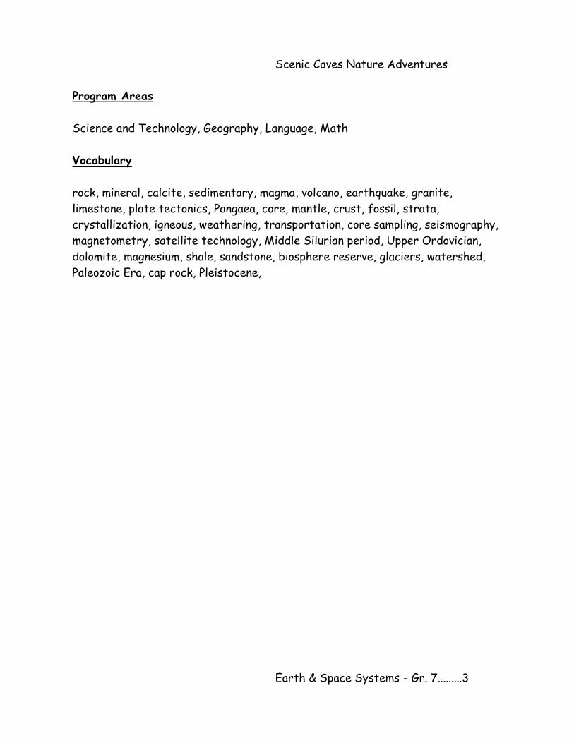
Program Areas
Science and Technology, Geography, Language, Math
Vocabulary
rock, mineral, calcite, sedimentary, magma, volcano, earthquake, granite,
limestone, plate tectonics, Pangaea, core, mantle, crust, fossil, strata,
crystallization, igneous, weathering, transportation, core sampling, seismography,
magnetometry, satellite technology, Middle Silurian period, Upper Ordovician,
dolomite, magnesium, shale, sandstone, biosphere reserve, glaciers, watershed,
Paleozoic Era, cap rock, Pleistocene,
Earth & Space Systems - Gr. 7.........3
Scenic Caves Nature Adventures
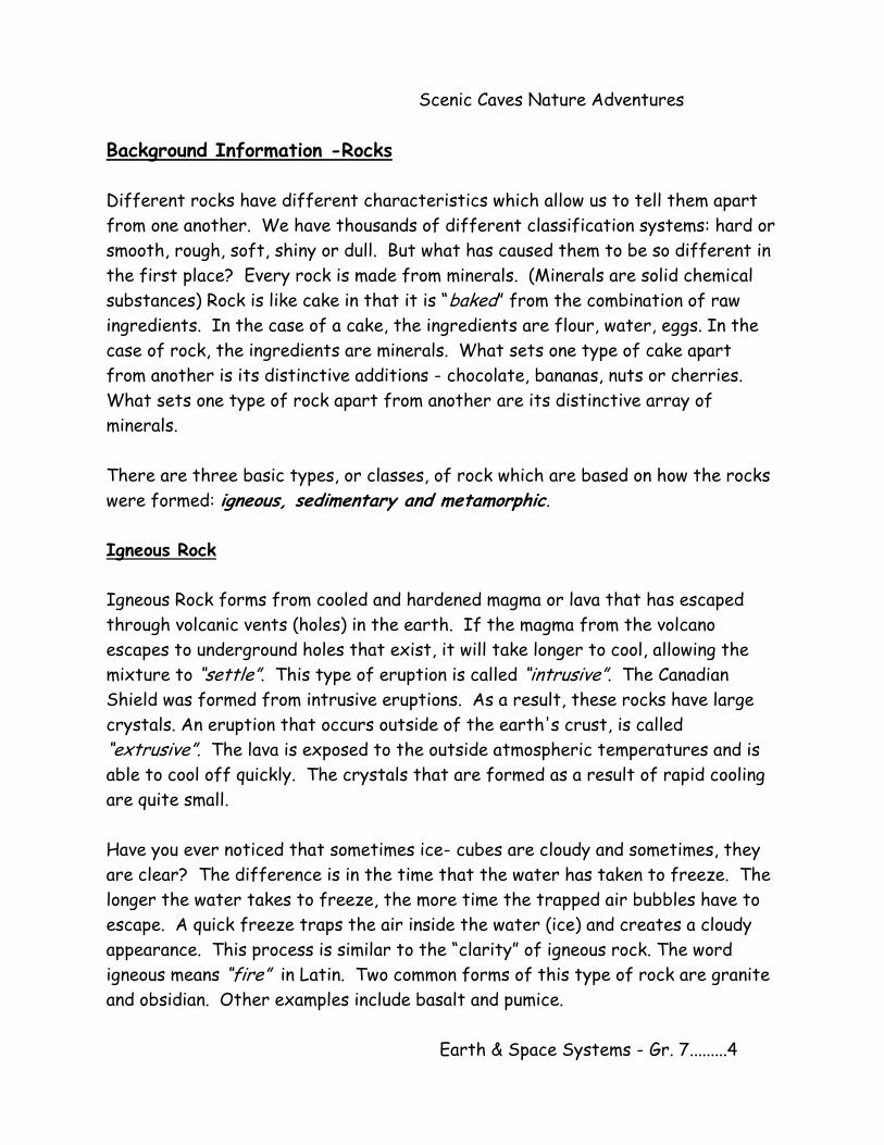
Background Information -Rocks
Different rocks have different characteristics which allow us to tell them apart
from one another. We have thousands of different classification systems: hard or
smooth, rough, soft, shiny or dull. But what has caused them to be so different in
the first place? Every rock is made from minerals. (Minerals are solid chemical
substances) Rock is like cake in that it is “baked” from the combination of raw
ingredients. In the case of a cake, the ingredients are flour, water, eggs. In the
case of rock, the ingredients are minerals. What sets one type of cake apart
from another is its distinctive additions - chocolate, bananas, nuts or cherries.
What sets one type of rock apart from another are its distinctive array of
minerals.
There are three basic types, or classes, of rock which are based on how the rocks
were formed: igneous, sedimentary and metamorphic.
Igneous Rock
Igneous Rock forms from cooled and hardened magma or lava that has escaped
through volcanic vents (holes) in the earth. If the magma from the volcano
escapes to underground holes that exist, it will take longer to cool, allowing the
mixture to “settle”. This type of eruption is called “intrusive”. The Canadian
Shield was formed from intrusive eruptions. As a result, these rocks have large
crystals. An eruption that occurs outside of the earth's crust, is called
“extrusive”. The lava is exposed to the outside atmospheric temperatures and is
able to cool off quickly. The crystals that are formed as a result of rapid cooling
are quite small.
Have you ever noticed that sometimes ice- cubes are cloudy and sometimes, they
are clear? The difference is in the time that the water has taken to freeze. The
longer the water takes to freeze, the more time the trapped air bubbles have to
escape. A quick freeze traps the air inside the water (ice) and creates a cloudy
appearance. This process is similar to the “clarity” of igneous rock. The word
igneous means “fire” in Latin. Two common forms of this type of rock are granite
and obsidian. Other examples include basalt and pumice.
Earth & Space Systems - Gr. 7.........4
Scenic Caves Nature Adventures
Rocks are being continually worn down by wind and rain. Tiny grains of dirt, sand,
mud and clay are worn off the rock and washed into streams, rivers, lakes and
oceans where they settle to the bottom of the water. This is known as
“sediment”. Minerals in the water mix with tiny sea animals and plants as they die
and sink to the bottom of the water. These, then also become part of the
sediment. Thus, sediment is composed of bones, leaves, teeth and other things
that drop to the bottom of a lake or an ocean. The sediment builds up over years
and finally after thousands and millions of years we end up with a really deep pile
of sediment - to form the second type of rock: sedimentary rock.
Sedimentary Rock
This type of rock is usually found near rivers. Sandstone is sedimentary rock.
Other examples include Limestone, Jasper, Gypsum, and Conglomerate.
The third type of rock is metamorphic.
Metamorphic Rock
Metamorphic means “changed in form”. These rocks were once a different kind of
rock. Examples include Quartz, Amethyst, Marble, Slate, Gneiss, Graphite and
Coal. The rock was somehow buried beneath the surface of the earth where it
was then exposed to heat and pressure for millions of years. Limestone
(sedimentary rock) can be changed to marble and sandstone (sedimentary) can be
changed into quartzite, also shale can be changed to slate. One type of rock
“metamorphoses” into another type of rock.
Background Information - Minerals
Minerals are inorganic (non-living) substances that are made from the same
chemicals and have the same crystal shape. The colour of a particular mineral is
determined by what is mixed in with the mineral. Some are mixed with a metal
that has a luster - this causes the mineral to shine. Minerals that do not contain
metals look dull. More than four thousand minerals have been discovered including
gold, silver, platinum, copper and diamond.
Earth & Space Systems - Gr. 7.........5
Scenic Caves Nature Adventures
Geologists use the physical properties of a mineral to identify it in the field.
These properties include colour, streak, luster, cleavage, specific gravity, and
hardness.
A scratch test developed by a German mineralogist named Fredriech Mohs in 1822
is used to determine hardness. Hardness is measured on a scale of 1-10 by how
easily a mineral can be scratched. Soft minerals which are more easily scratched
are given low numbers. Hard minerals are given higher numbers.
Another way minerals are classified is by doing a streak test. The streak of a
mineral is the colour of its fine powder.
Background Information - Fossils
Fossils are the remains of plants and animals that are found in rock. Some fossils
are the actual plant or animal remains that have been mineralized. This process
occurs when the original materials in an organism are replaced by minerals. Other
fossils are impressions made in soft sediment by organisms, such as the tracks of
animals left in mud.
Fossils are found most often in sedimentary rocks. The processes that create
igneous rock and metamorphic rock usually destroy any pre-existing fossils.
Coal, oil, and natural gas are fossil fuels that are the remains of prehistoric plants
and animals. These organisms died and were trapped beneath layers of
sedimentary rock and lost most of the minerals they contained, leaving mostly
carbon. The remaining carbon was heated to form fossil fuels. We use fossil fuels
for fuel, heat, and in the production of synthetic materials such as plastics and
fibers such as nylon, orlon, and dacron.
Earth & Space Systems - Gr. 7.........6
Scenic Caves Nature Adventures
The Earth’s Crust - in the beginning
The Earth was probably born from clouds of gas and dust thrown out by the Sun.
The dust and gas began to spin around its own axis and formed a ball. At the
centre of the ball was molten (melted) iron. The surface emitted superheated
gasses: carbon dioxide, nitrogen and water vapour. As the heat escaped, the
planet began to form and the molten rock developed a crust - similar to the crust
that is formed on baked bread. Volcanoes released the molten rock that was
trapped below the crust. Meteorites that stuck to the surface also punched holes
in the crust where molten rock could escape. The lightest materials floated to
the surface: gasses and water vapour escaped with the molten rock and then
condensed to form clouds. These clouds existed for thousands of years - and with
them came global rain storms. Thus the formation of the world’s oceans. As the
world cooled and the crust thickened, continents were formed from the lightest
materials. The heaviest materials remained in the middle - iron remains at the
core. Today, the world is still evolving. Cracks in the crust continue to grow and
change. It is through these cracks that magma is released in the form of
volcanoes.
Structure Of The Earth
The earth is made up of three layers. Covering the outside of the earth is a thin,
solid layer called the “crust”. The thickness of the crust differs from place to
place. The parts of the crust that make up the sea floor are from 4-7 km thick.
Under the continents, the crust is about 35 km thick and beneath some mountains,
the crust is as much as 70 km thick. We know more about the crust than any
other layer because we can see rock and soil. However, the crust makes up only
one percent of the earth's volume.
Beneath the crust is a very thick layer called the “mantle”. The mantle reaches to
a depth of about 2,900 km beneath the crust. It makes up about 80 percent of
the earth's volume and represents almost two-thirds of the earth's mass.
Earth & Space Systems - Gr. 7.........7
Scenic Caves Nature Adventures
Deep in the earth's centre is a very dense core. It is made up of a solid inner core
surrounded by a liquid outer core. The core makes up 19 percent of the earth's
volume and nearly one-third of its mass. Of all the substances commonly found in
the earth, only a mixture of iron and nickel is dense enough to account for the
denseness of the core.
The crust is broken into distinct pieces, called “plates”. These plates float on the
molten material below. Since the molten material is a liquid, it moves. As a result,
the hard crust floating on top is also subject to movement. The shifting of the
plates is called “plate tectonics”.
There are about ten plates that make up the crust of the earth. The plates lie
very close together, but they can move in response to the pressure from built-up
heat and gasses in the interior. The crust’s plates sometimes push against each
other, move apart, or slide past each other. This motion causes the earth to
literally shake. The shake is called an “earthquake”. This same pressure can also
cause volcanoes.
Volcanoes are located above a pool of magma. The magma generates heat and
gasses which become so great, that they must find a way to escape. The pressure
can cause the land to swell.
Shield volcanoes form wide gently sloping mountains and islands. They have mild
eruptions where thin runny lava oozes out of vents or cracks. They look like huge
overturned shields. Sometimes shield volcanoes erupt under the ocean, and then
they are built higher and higher until they form islands.
Cinder cones look like lamp shades. During their fiery outbursts, lava and ash go
miles into the sky through a crater, a bowl-shaped crack.
The third kind of volcanoes are called “volcanic domes”. They are a combination of
a shield volcano and a cinder cone. First they erupt quietly with thin runny lava,
then they erupt violently with lava, cinder and dust. Volcanic domes form towering
mountains like upside down ice cream cones.
Earth & Space Systems - Gr. 7.........8
Scenic Caves Nature Adventures
Continental Drift
At one point in earth’s history, all the continents were attached as one super-
continent known as “Pangaea”. Over a very long period of time, the pressures
inside the earth that caused earthquakes and volcanoes cracked the crust of
Pangaea, dividing it into several plates. The motion of the mantle and build up of
gasses and heat caused the plates to continue to move apart and finally caused
Pangaea to break into smaller pieces. These pieces are today’s continents. This
motion is called continental drift - which continues to change the location of the
plates even today.
There are several interesting things that have been discovered that support this
theory of the existence of Pangaea. The same fossils, for example, that are
found in Africa are also found in South America. Since these animals could not
have crossed the Atlantic Ocean, the two continents must have been joined at one
time. Further, the shape of the east coast of South America fits like a piece of a
puzzle into the west coast of Africa.
Technology
As the world's population grows, more and more people are being forced to live in
potentially dangerous volcanic areas. Volcanic eruptions continue regardless of
human habitation. This inhospitable co-existence poses ever-greater threats to
life and property.
Mt. Rainier looms over the Seattle/Tacoma area, endangering a population of more
than three million people. South of Mexico City, Popocatépetl has come to life
again, putting a million nearby residents at risk. Another million people living in
the Naples area are threatened by Mt. Vesuvius's continued unrest.
It is possible that these volcanoes will erupt once again - will people be able to
flee before being harmed or killed by the volcano? Past eruptions can sometimes
provide clues as to future behaviour. Thus, scientists look to find clues about past
eruptions by studying the deposits left behind. Areas affected by lava flows,
debris flows, tephra, or pyroclastic flows can be mapped, making disaster planning
more effective. Further, scientists are becoming more and more skilled at
spotting the warning signs of an eruption.
Earth & Space Systems - Gr. 7.........9
Scenic Caves Nature Adventures
Before an eruption, magma moves into the area beneath the volcano and collects in
a magma chamber, or reservoir. As it comes closer to the surface, as previously
mentioned, the magma releases gasses. These particular events offer clues about
the likelihood of an eruption. For example, the movement of magma produces small
earthquakes and vibrations (seismicity). Magma gathering in a chamber causes
slight swelling of the volcano's slopes. Gases released near the volcano can be
measured for changes in quantity and makeup.
Erosion
Our landscape appears stable, but in fact, is subject to massive changes. Rocks
are slowly crumbling. Winds grind down rocks. Fields are losing their soil. Water
carries away sediment and deposits it somewhere else. The earth's surface is
changing all the time. Water, wind, and ice are constantly at work, wearing away
and building up the land.
Some changes take place in a very short time. Floods can change the course of a
river in a few days. Dust storms can carry huge amounts of soil away very rapidly.
However, most of the big changes in the earth's surface take thousands of years.
At various times, the earth is exposed to along periods of extreme cold followed
by periods of intense heat. Parts of the land we see now, were once under water.
The Niagara Escarpment, for example, was once the shore of a shallow salt-water
lake. The area to the west of the Escarpment was covered with water.
Some of these erosive changes are chemical, while others are physical. Chemical
weathering (acid rain) causes chemical changes in the minerals of a rock. It
usually proceeds more rapidly in warm, moist climates. Physical weathering occurs
when rocks are reduced to smaller fragments without being changed chemically
and it is more likely to occur in cooler, more dry climates. Among the physical
processes of weathering are ice, water, wind, and changes in temperature.
Collingwood Scenic Caves demonstrates excellent evidence of physical weathering.
Cracks in the rocks let air and water in. Weathering then goes on inside the rocks
as well as on the outside. Water begins its eroding and dissolving action. When
freezing occurs, the expansion of the water exerts tremendous pressure. This
causes the rock mass to break into smaller pieces. This is the rock that is found
at the bottom of the rock face.
Earth & Space Systems - Gr. 7.........10
Scenic Caves Nature Adventures
Wind is a powerful erosive agent. Grains of blown sand can act like tiny chisels,
scratching and scraping whatever surface they strike. In a sandstorm, cars can
have their paint worn off in minutes.
Ice is another kind of erosive element. The glaciers moved incredible amounts of
rock and soil. Over much of the southern part of our country is a layer of soil and
rock that was not formed there. In some places this layer is 500 feet deep. This
soil came from somewhere else. Huge glaciers, moved down from the north and
then melted. They brought with them many cubic miles of rock, sand, and clay. As
these glaciers moved along, they picked up rocks and ground them into fragments
against one another. Rock particles embedded in the lower levels and sides of the
glaciers scoured rock powder from the bedrock of the glacier's path. When the
ice melted, the rock fragments and powder were either immediately deposited or
carried away many miles by water flowing from the glacier. As the glaciers moved
they also smoothed off hilltops and filled in valleys. Niagara Falls has its present
form because of them. They also formed the Great Lakes and countless smaller
lakes.
Erosion can also be caused by non-natural forces. Agriculture, construction and
logging remove ground cover, which speeds the process of soil erosion. This causes
two types of problems. First, the loss of soil impacts the land's ability to support
plant life. Without plants, animals will not move into the area, and those already
in the area will starve. Second, the soil that is eroded away ends up in the water.
Millions of tons of sediment are added to bodies of water each year, as are the
fertilizers, pesticides and other pollutants the sediment carries with it. This
additional sediment changes the aquatic ecosystem, affecting the plants and
animals in the water.
Landslides and mudslides are yet another form of disaster that has increased in
frequency as a result of erosion due to the logging industry. Without trees to
slow the flow of water down a hillside, the soil has nothing to hold it in place. In
Bangladesh, a large amount of soil is lost to the ocean on a regular basis.
Earth & Space Systems - Gr. 7.........11
Scenic Caves Nature Adventures
Soil
Soil is the result of the process of the gradual breakdown of rock - the solid
geology that makes up the earth. As rock becomes broken down through a variety
of processes, such as weathering and erosion, the particles become ground smaller
and smaller. There are considered to be three main parts to soil; ‘sand’, ‘silt’ and
‘clay’. These parts give the soil its mineral texture. In addition, as leaves and
other organic material fall to the ground and decompose - there forms an ‘organic’
layer.
Soil, like freshwater, is vital to many of Earth’s ecosystems. Scientists estimate
that each year the world loses about 11 million hectares of arable land (land that
could be used for growing plants). Non-agricultural use of farmland, contaminant
entering the soil, desertification and erosion are some of the causes. In the
Western Province, erosion affects 12 percent of farmland. Loss of farmland in
the United States may drastically reduce grain exports by the middle of the next
century.
Nearly 90 percent of all trees harvested in Canada is done by clear-cutting, which
exposes the soil to wind and water erosion.
Urban development replaces over one million hectares of farmland a year in North
America. Today we need to learn how to reverse the damage that erosion has
caused in many countries as a result of human interferences.
A number of tools can be used to record these warning signs. Seismographs can
detect small earthquakes while tiltmeters and geodimeters can measure any slight
swelling of a volcano. Correlation spectrometers (COSPECS) can measure amounts
of sulfur dioxide--a gas that is released in increasing quantities before an
eruption. Using these and other tools, it's possible to closely monitor activity at
an awakening volcano.
Volcanologists are becoming more skilled at predicting the likelihood of an
eruption. It remains, however, very difficult to pinpoint exactly when an eruption
will occur. Often, moving magma doesn't result in an eruption, but instead cools
below the surface (intrusive eruption).
Earth & Space Systems - Gr. 7.........12
Scenic Caves Nature Adventures
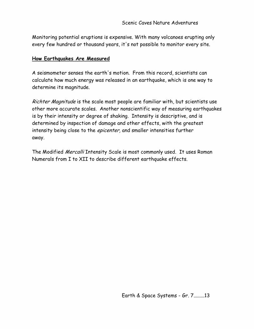
Monitoring potential eruptions is expensive. With many volcanoes erupting only
every few hundred or thousand years, it's not possible to monitor every site.
How Earthquakes Are Measured
A seismometer senses the earth's motion. From this record, scientists can
calculate how much energy was released in an earthquake, which is one way to
determine its magnitude.
Richter Magnitude is the scale most people are familiar with, but scientists use
other more accurate scales. Another nonscientific way of measuring earthquakes
is by their intensity or degree of shaking. Intensity is descriptive, and is
determined by inspection of damage and other effects, with the greatest
intensity being close to the epicenter, and smaller intensities further
away.
The Modified Mercalli Intensity Scale is most commonly used. It uses Roman
Numerals from I to XII to describe different earthquake effects.
Earth & Space Systems - Gr. 7.........13
Scenic Caves Nature Adventures
Name: __________________
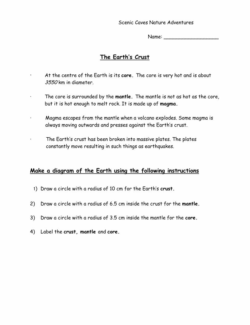
The Earth’s Crust · At the centre of the Earth is its core. The core is very hot and is about
3550 km in diameter.
· The core is surrounded by the mantle. The mantle is not as hot as the core,
but it is hot enough to melt rock. It is made up of magma.
· Magma escapes from the mantle when a volcano explodes. Some magma is
always moving outwards and presses against the Earth’s crust.
· The Earth’s crust has been broken into massive plates. The plates
constantly move resulting in such things as earthquakes.
Make a diagram of the Earth using the following instructions
1) Draw a circle with a radius of 10 cm for the Earth’s crust.
2) Draw a circle with a radius of 6.5 cm inside the crust for the mantle.
3) Draw a circle with a radius of 3.5 cm inside the mantle for the core.
4) Label the crust, mantle and core.
Earth & Space Systems - Gr. 7.........14
Scenic Caves Nature Adventures
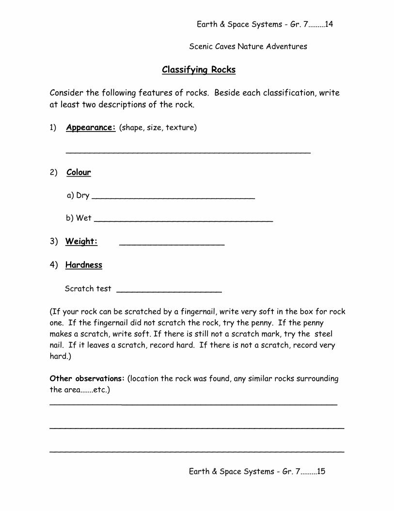
Classifying Rocks
Consider the following features of rocks. Beside each classification, write
at least two descriptions of the rock.
1) Appearance: (shape, size, texture)
___________________________________________________
2) Colour
a) Dry __________________________________
b) Wet __________________________________
3) Weight: ____________________
4) Hardness
Scratch test ____________________
(If your rock can be scratched by a fingernail, write very soft in the box for rock
one. If the fingernail did not scratch the rock, try the penny. If the penny
makes a scratch, write soft. If there is still not a scratch mark, try the steel
nail. If it leaves a scratch, record hard. If there is not a scratch, record very
hard.)
Other observations: (location the rock was found, any similar rocks surrounding
the area.......etc.)
________________________________________________________
________________________________________________________
________________________________________________________
Earth & Space Systems - Gr. 7.........15
Scenic Caves Nature Adventures
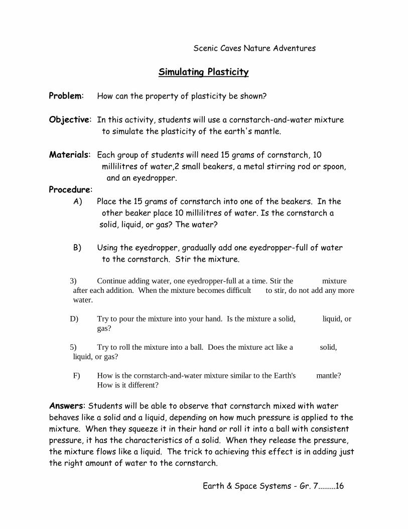
Simulating Plasticity
Problem: How can the property of plasticity be shown?
Objective: In this activity, students will use a cornstarch-and-water mixture
to simulate the plasticity of the earth's mantle.
Materials: Each group of students will need 15 grams of cornstarch, 10
millilitres of water,2 small beakers, a metal stirring rod or spoon,
and an eyedropper.
Procedure: A) Place the 15 grams of cornstarch into one of the beakers. In the
other beaker place 10 millilitres of water. Is the cornstarch a
solid, liquid, or gas? The water?
B) Using the eyedropper, gradually add one eyedropper-full of water
to the cornstarch. Stir the mixture.
3) Continue adding water, one eyedropper-full at a time. Stir the mixture
after each addition. When the mixture becomes difficult to stir, do not add any more
water.
D) Try to pour the mixture into your hand. Is the mixture a solid, liquid, or
gas?
5) Try to roll the mixture into a ball. Does the mixture act like a solid,
liquid, or gas?
F) How is the cornstarch-and-water mixture similar to the Earth's mantle?
How is it different?
Answers: Students will be able to observe that cornstarch mixed with water
behaves like a solid and a liquid, depending on how much pressure is applied to the
mixture. When they squeeze it in their hand or roll it into a ball with consistent
pressure, it has the characteristics of a solid. When they release the pressure,
the mixture flows like a liquid. The trick to achieving this effect is in adding just
the right amount of water to the cornstarch.
Earth & Space Systems - Gr. 7.........16
Scenic Caves Nature Adventures
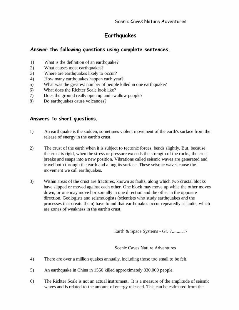
Earthquakes
Answer the following questions using complete sentences.
1) What is the definition of an earthquake?
2) What causes most earthquakes?
3) Where are earthquakes likely to occur?
4) How many earthquakes happen each year?
5) What was the greatest number of people killed in one earthquake?
6) What does the Richter Scale look like?
7) Does the ground really open up and swallow people?
8) Do earthquakes cause volcanoes?
Answers to short questions. 1) An earthquake is the sudden, sometimes violent movement of the earth's surface from the
release of energy in the earth's crust.
2) The crust of the earth when it is subject to tectonic forces, bends slightly. But, because
the crust is rigid, when the stress or pressure exceeds the strength of the rocks, the crust
breaks and snaps into a new position. Vibrations called seismic waves are generated and
travel both through the earth and along its surface. These seismic waves cause the
movement we call earthquakes.
3) Within areas of the crust are fractures, known as faults, along which two crustal blocks
have slipped or moved against each other. One block may move up while the other moves
down, or one may move horizontally in one direction and the other in the opposite
direction. Geologists and seismologists (scientists who study earthquakes and the
processes that create them) have found that earthquakes occur repeatedly at faults, which
are zones of weakness in the earth's crust.
Earth & Space Systems - Gr. 7.........17
Scenic Caves Nature Adventures
4) There are over a million quakes annually, including those too small to be felt.
5) An earthquake in China in 1556 killed approximately 830,000 people.
6) The Richter Scale is not an actual instrument. It is a measure of the amplitude of seismic
waves and is related to the amount of energy released. This can be estimated from the
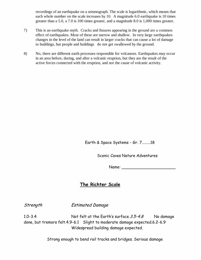
recordings of an earthquake on a seismograph. The scale is logarithmic, which means that
each whole number on the scale increases by 10. A magnitude 6.0 earthquake is 10 times
greater than a 5.0, a 7.0 is 100 times greater, and a magnitude 8.0 is 1,000 times greater.
7) This is an earthquake myth. Cracks and fissures appearing in the ground are a common
effect of earthquakes. Most of these are narrow and shallow. In very large earthquakes
changes in the level of the land can result in larger cracks that can cause a lot of damage
to buildings, but people and buildings do not get swallowed by the ground.
8) No, there are different earth processes responsible for volcanoes. Earthquakes may occur
in an area before, during, and after a volcanic eruption, but they are the result of the
active forces connected with the eruption, and not the cause of volcanic activity.
Earth & Space Systems - Gr. 7.........18
Scenic Caves Nature Adventures
Name: ______________________
The Richter Scale
Strength Estimated Damage
1.0-3.4 Not felt at the Earth’s surface.3.5-4.8 No damage
done, but tremors felt.4.9-6.1 Slight to moderate damage expected.6.2-6.9
Widespread building damage expected.
7.0-7.9 Strong enough to bend rail tracks and bridges. Serious damage
expected.
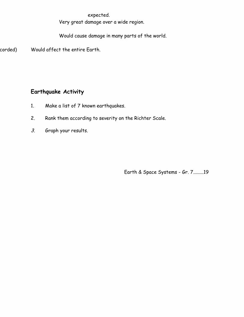
8.0-8.6 Very great damage over a wide region.
8.7-9.0 Would cause damage in many parts of the world.
10 (never recorded) Would affect the entire Earth.
Earthquake Activity 1. Make a list of 7 known earthquakes.
2. Rank them according to severity on the Richter Scale.
3. Graph your results.
Earth & Space Systems - Gr. 7.........19
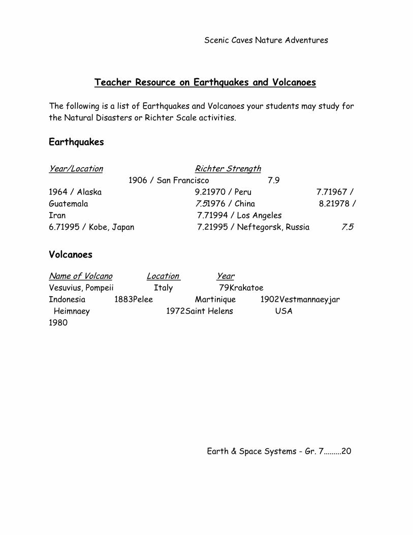
Scenic Caves Nature Adventures
Teacher Resource on Earthquakes and Volcanoes The following is a list of Earthquakes and Volcanoes your students may study for
the Natural Disasters or Richter Scale activities.
Earthquakes Year/Location Richter Strength 1906 / San Francisco 7.9
1964 / Alaska 9.21970 / Peru 7.71967 /
Guatemala 7.51976 / China 8.21978 /
Iran 7.71994 / Los Angeles
6.71995 / Kobe, Japan 7.21995 / Neftegorsk, Russia 7.5
Volcanoes
Name of Volcano Location Year
Vesuvius, Pompeii Italy 79Krakatoe
Indonesia 1883Pelee Martinique 1902Vestmannaeyjar
Heimnaey 1972Saint Helens USA
1980
Earth & Space Systems - Gr. 7.........20
Scenic Caves Nature Adventures
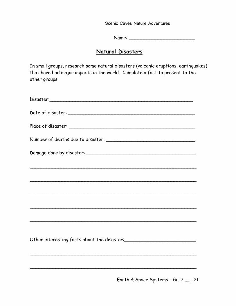
Name: _______________________
Natural Disasters
In small groups, research some natural disasters (volcanic eruptions, earthquakes)
that have had major impacts in the world. Complete a fact to present to the
other groups.
Disaster:__________________________________________________
Date of disaster: ____________________________________________
Place of disaster: ____________________________________________
Number of deaths due to disaster: _______________________________
Damage done by disaster: ______________________________________
__________________________________________________________
__________________________________________________________
__________________________________________________________
__________________________________________________________
__________________________________________________________
Other interesting facts about the disaster:_________________________
__________________________________________________________
__________________________________________________________
Earth & Space Systems - Gr. 7.........21
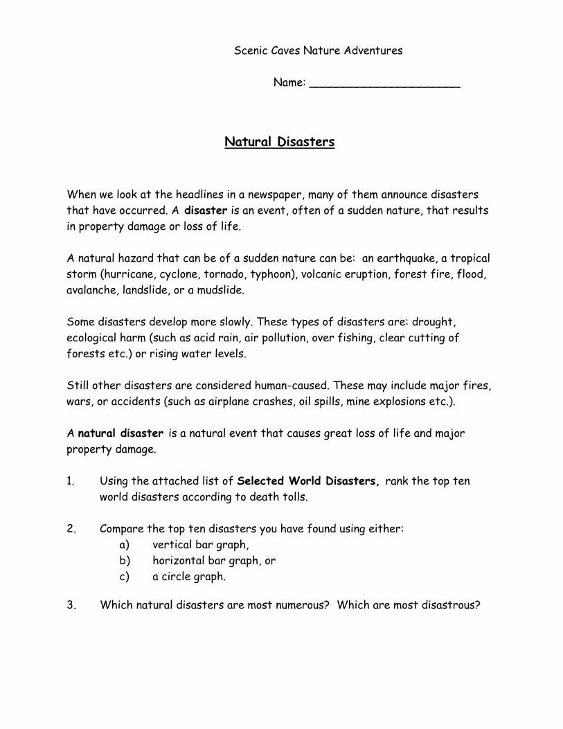
Scenic Caves Nature Adventures
Name: ______________________
Natural Disasters When we look at the headlines in a newspaper, many of them announce disasters
that have occurred. A disaster is an event, often of a sudden nature, that results
in property damage or loss of life.
A natural hazard that can be of a sudden nature can be: an earthquake, a tropical
storm (hurricane, cyclone, tornado, typhoon), volcanic eruption, forest fire, flood,
avalanche, landslide, or a mudslide.
Some disasters develop more slowly. These types of disasters are: drought,
ecological harm (such as acid rain, air pollution, over fishing, clear cutting of
forests etc.) or rising water levels.
Still other disasters are considered human-caused. These may include major fires,
wars, or accidents (such as airplane crashes, oil spills, mine explosions etc.).
A natural disaster is a natural event that causes great loss of life and major
property damage.
1. Using the attached list of Selected World Disasters, rank the top ten
world disasters according to death tolls.
2. Compare the top ten disasters you have found using either:
a) vertical bar graph,
b) horizontal bar graph, or
c) a circle graph.
3. Which natural disasters are most numerous? Which are most disastrous?
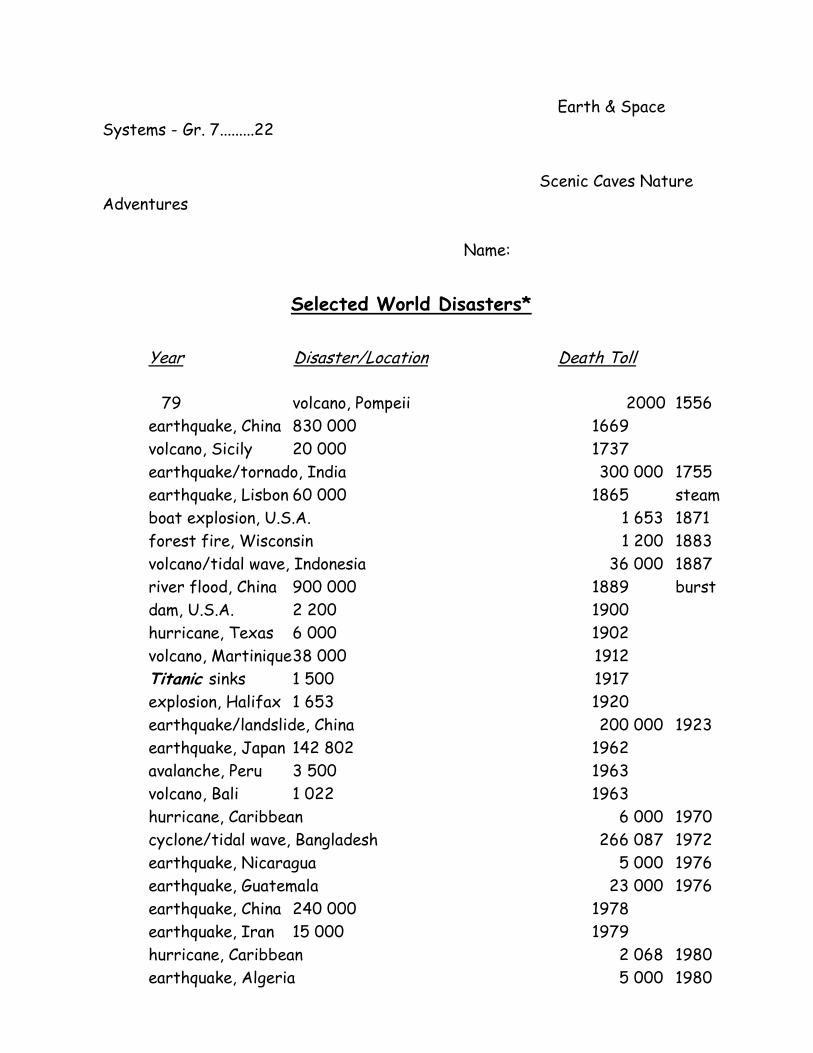
Earth & Space
Systems - Gr. 7.........22 Scenic Caves Nature
Adventures
Name:
Selected World Disasters*
Year Disaster/Location Death Toll
79 volcano, Pompeii 2000 1556
earthquake, China 830 000 1669
volcano, Sicily 20 000 1737
earthquake/tornado, India 300 000 1755
earthquake, Lisbon 60 000 1865 steam
boat explosion, U.S.A. 1 653 1871
forest fire, Wisconsin 1 200 1883
volcano/tidal wave, Indonesia 36 000 1887
river flood, China 900 000 1889 burst
dam, U.S.A. 2 200 1900
hurricane, Texas 6 000 1902
volcano, Martinique 38 000 1912
Titanic sinks 1 500 1917
explosion, Halifax 1 653 1920
earthquake/landslide, China 200 000 1923
earthquake, Japan 142 802 1962
avalanche, Peru 3 500 1963
volcano, Bali 1 022 1963
hurricane, Caribbean 6 000 1970
cyclone/tidal wave, Bangladesh 266 087 1972
earthquake, Nicaragua 5 000 1976
earthquake, Guatemala 23 000 1976
earthquake, China 240 000 1978
earthquake, Iran 15 000 1979
hurricane, Caribbean 2 068 1980
earthquake, Algeria 5 000 1980
earthquake, Italy 3 150 1981 river
floods, China 1 517 1981
earthquakes, Iran 2 500
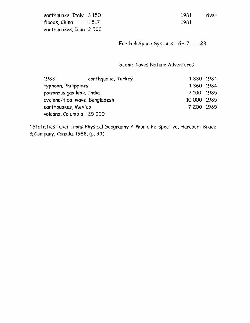
Earth & Space Systems - Gr. 7.........23
Scenic Caves Nature Adventures
1983 earthquake, Turkey 1 330 1984
typhoon, Philippines 1 360 1984
poisonous gas leak, India 2 100 1985
cyclone/tidal wave, Bangladesh 10 000 1985
earthquakes, Mexico 7 200 1985
volcano, Columbia 25 000
*Statistics taken from: Physical Geography A World Perspective, Harcourt Brace
& Company, Canada. 1988. (p. 93).
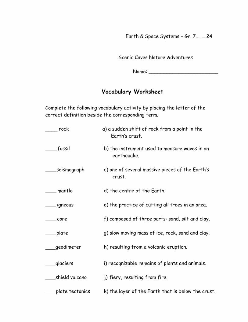
Earth & Space Systems - Gr. 7.........24
Scenic Caves Nature Adventures
Name: _______________________
Vocabulary Worksheet Complete the following vocabulary activity by placing the letter of the
correct definition beside the corresponding term.
____ rock a) a sudden shift of rock from a point in the
Earth’s crust.
fossil b) the instrument used to measure waves in an
earthquake.
seismograph c) one of several massive pieces of the Earth’s
crust.
mantle d) the centre of the Earth.
igneous e) the practice of cutting all trees in an area.
core f) composed of three parts: sand, silt and clay.
plate g) slow moving mass of ice, rock, sand and clay.
geodimeter h) resulting from a volcanic eruption.
glaciers i) recognizable remains of plants and animals.
shield volcano j) fiery, resulting from fire.
plate tectonics k) the layer of the Earth that is below the crust.
earthquake l) the weathering down of the physical
environment.
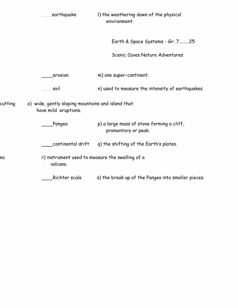
Earth & Space Systems - Gr. 7.........25
Scenic Caves Nature Adventures
erosion m) one super-continent.
soil n) used to measure the intensity of earthquakes.
____________ clear cutting o) wide, gently sloping mountains and island that
have mild eruptions.
Pangea p) a large mass of stone forming a cliff,
promontory or peak.
continental drift q) the shifting of the Earth’s plates.
magma r) instrument used to measure the swelling of a
volcano.
Richter scale s) the break up of the Pangea into smaller pieces.
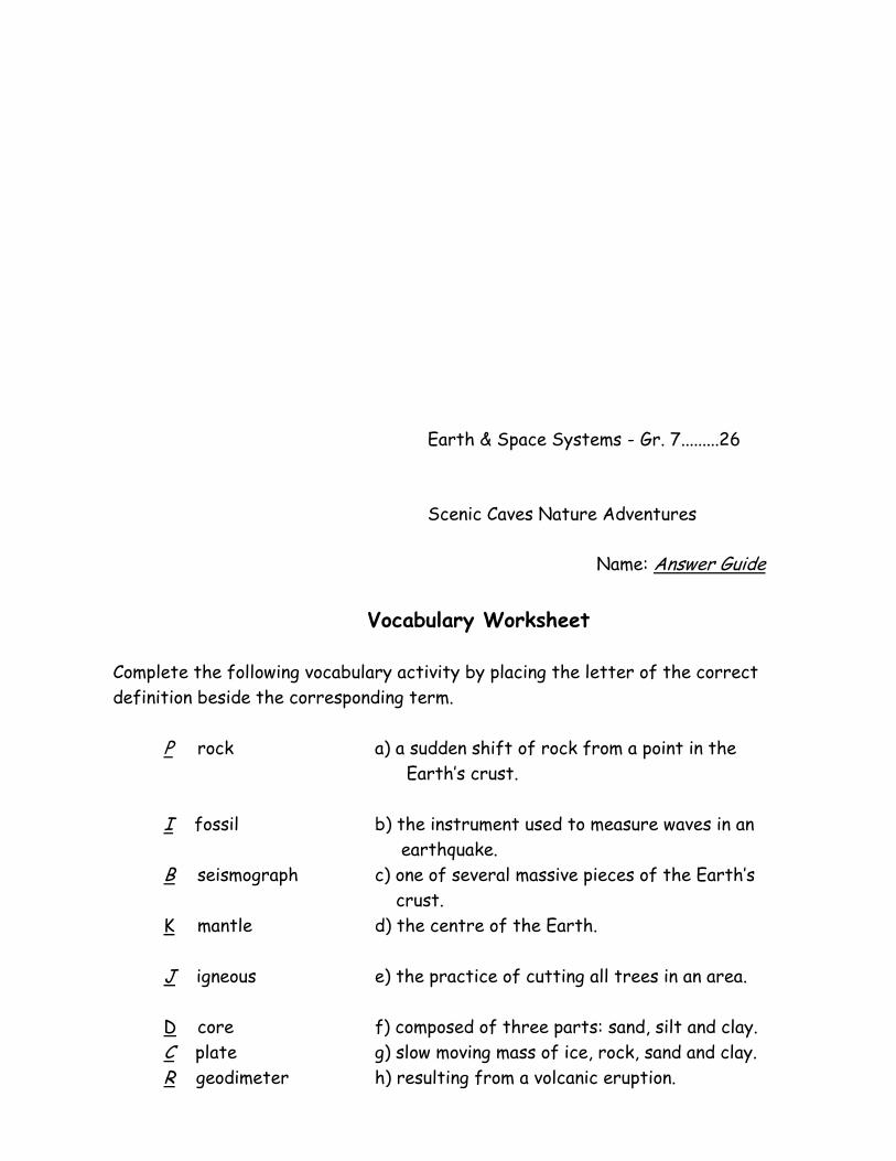
Earth & Space Systems - Gr. 7.........26
Scenic Caves Nature Adventures
Name: Answer Guide
Vocabulary Worksheet
Complete the following vocabulary activity by placing the letter of the correct
definition beside the corresponding term.
P rock a) a sudden shift of rock from a point in the
Earth’s crust.
I fossil b) the instrument used to measure waves in an
earthquake.
B seismograph c) one of several massive pieces of the Earth’s
crust.
K mantle d) the centre of the Earth.
J igneous e) the practice of cutting all trees in an area.
D core f) composed of three parts: sand, silt and clay.
C plate g) slow moving mass of ice, rock, sand and clay.
R geodimeter h) resulting from a volcanic eruption.
G glaciers i) recognizable remains of plants and animals.
O shield volcano j) fiery, resulting from fire.
Q plate tectonics k) the layer of the Earth that is below the crust.
A earthquake l) the weathering down of the physical
environment.
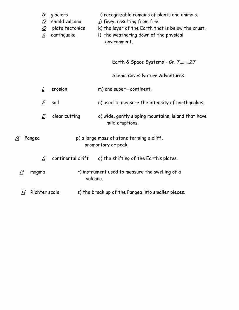
Earth & Space Systems - Gr. 7.........27
Scenic Caves Nature Adventures
L erosion m) one super—continent.
F soil n) used to measure the intensity of earthquakes.
E clear cutting o) wide, gently sloping mountains, island that have
mild eruptions.
M Pangea p) a large mass of stone forming a cliff,
promontory or peak.
S continental drift q) the shifting of the Earth’s plates.
H magma r) instrument used to measure the swelling of a
volcano.
H Richter scale s) the break up of the Pangea into smaller pieces.
Earth & Space Systems - Gr. 7.........28
Scenic Caves Nature Adventures
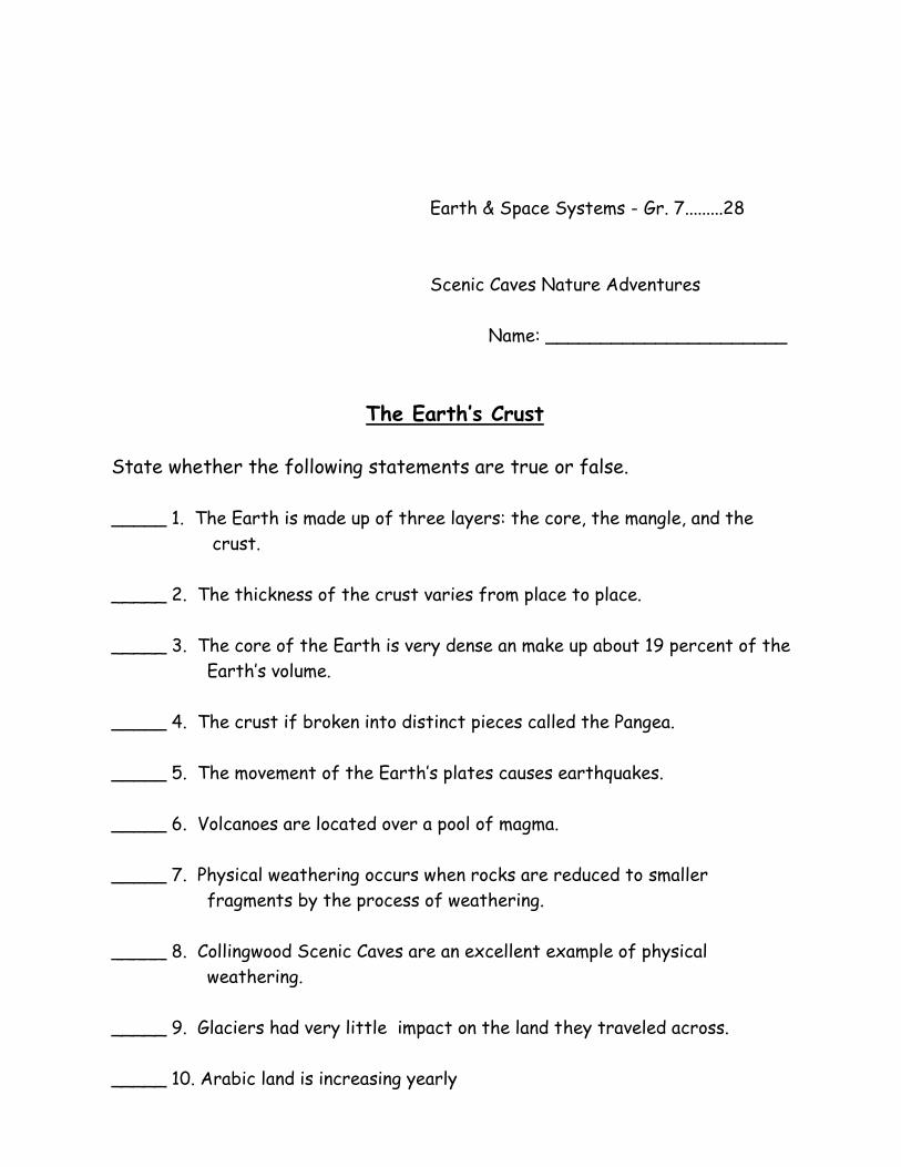
Name: ______________________
The Earth’s Crust
State whether the following statements are true or false.
_____ 1. The Earth is made up of three layers: the core, the mangle, and the
crust.
_____ 2. The thickness of the crust varies from place to place.
_____ 3. The core of the Earth is very dense an make up about 19 percent of the
Earth’s volume.
_____ 4. The crust if broken into distinct pieces called the Pangea.
_____ 5. The movement of the Earth’s plates causes earthquakes.
_____ 6. Volcanoes are located over a pool of magma.
_____ 7. Physical weathering occurs when rocks are reduced to smaller
fragments by the process of weathering.
_____ 8. Collingwood Scenic Caves are an excellent example of physical
weathering.
_____ 9. Glaciers had very little impact on the land they traveled across.
_____ 10. Arabic land is increasing yearly
_____ 11. Trees harvested in Canada are largely done by clear cutting.
_____ 12. Urban development replaces 100 000 hectares of farmland a year in
North America.
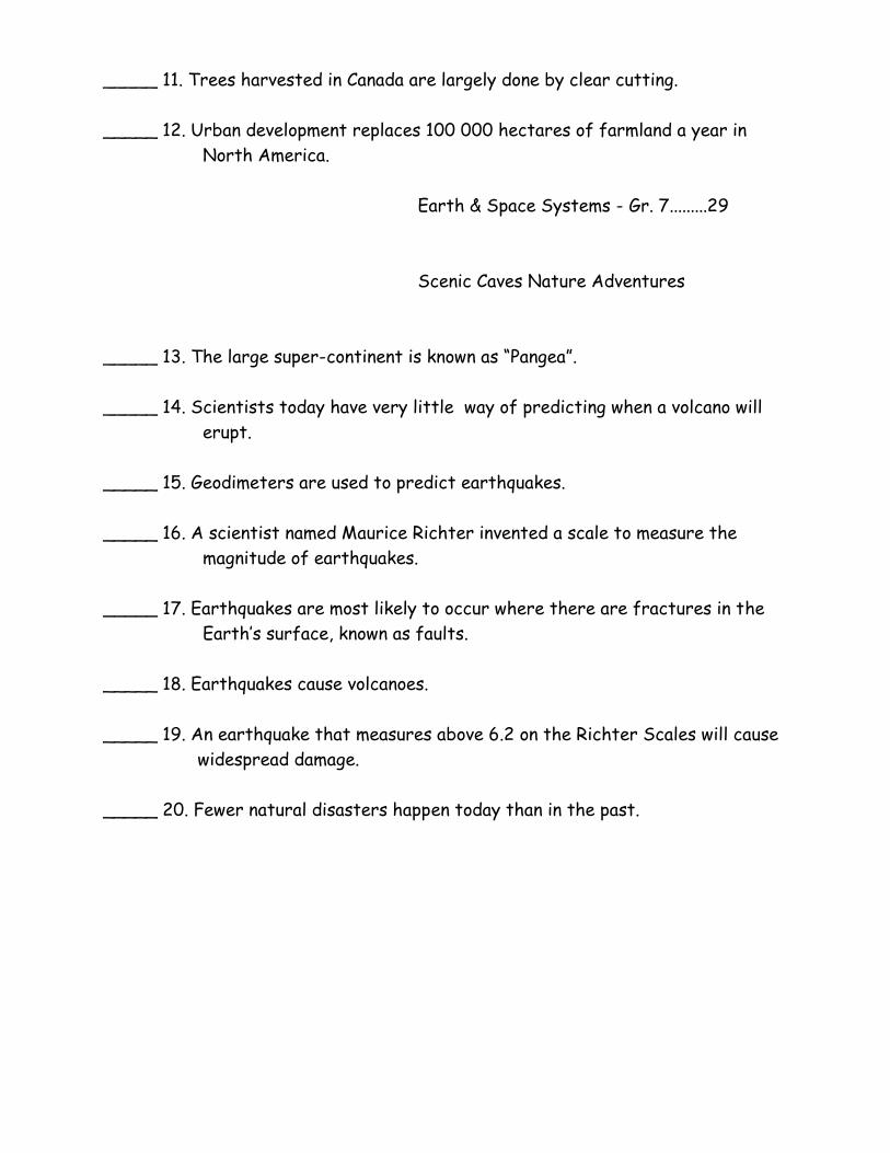
Earth & Space Systems - Gr. 7.........29
Scenic Caves Nature Adventures
_____ 13. The large super-continent is known as “Pangea”.
_____ 14. Scientists today have very little way of predicting when a volcano will
erupt.
_____ 15. Geodimeters are used to predict earthquakes.
_____ 16. A scientist named Maurice Richter invented a scale to measure the
magnitude of earthquakes.
_____ 17. Earthquakes are most likely to occur where there are fractures in the
Earth’s surface, known as faults.
_____ 18. Earthquakes cause volcanoes.
_____ 19. An earthquake that measures above 6.2 on the Richter Scales will cause
widespread damage.
_____ 20. Fewer natural disasters happen today than in the past.
Earth & Space Systems - Gr. 7.........30
Scenic Caves Nature Adventures
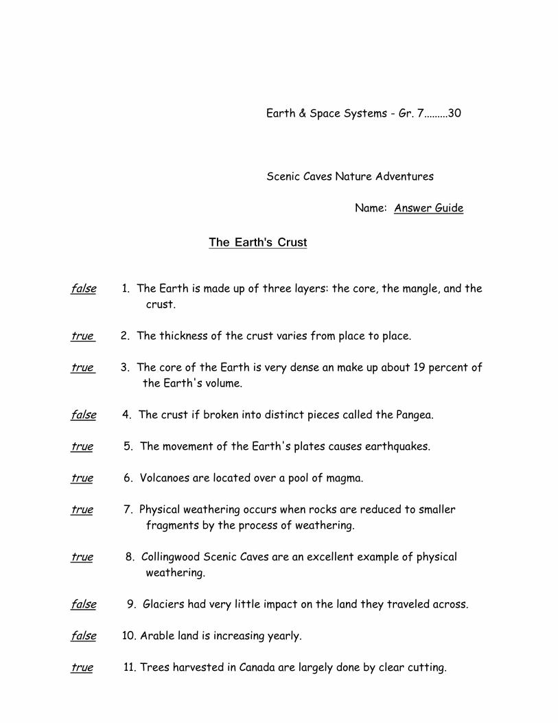
Name: Answer Guide
The Earth's Crust
false 1. The Earth is made up of three layers: the core, the mangle, and the
crust.
true 2. The thickness of the crust varies from place to place.
true 3. The core of the Earth is very dense an make up about 19 percent of
the Earth's volume.
false 4. The crust if broken into distinct pieces called the Pangea.
true 5. The movement of the Earth's plates causes earthquakes.
true 6. Volcanoes are located over a pool of magma.
true 7. Physical weathering occurs when rocks are reduced to smaller
fragments by the process of weathering.
true 8. Collingwood Scenic Caves are an excellent example of physical
weathering.
false 9. Glaciers had very little impact on the land they traveled across.
false 10. Arable land is increasing yearly.
true 11. Trees harvested in Canada are largely done by clear cutting.
false 12. Urban development replaces 100 000 hectares of farmland a year in
North America.
true 13. The large super-continent is known as "Pangea".
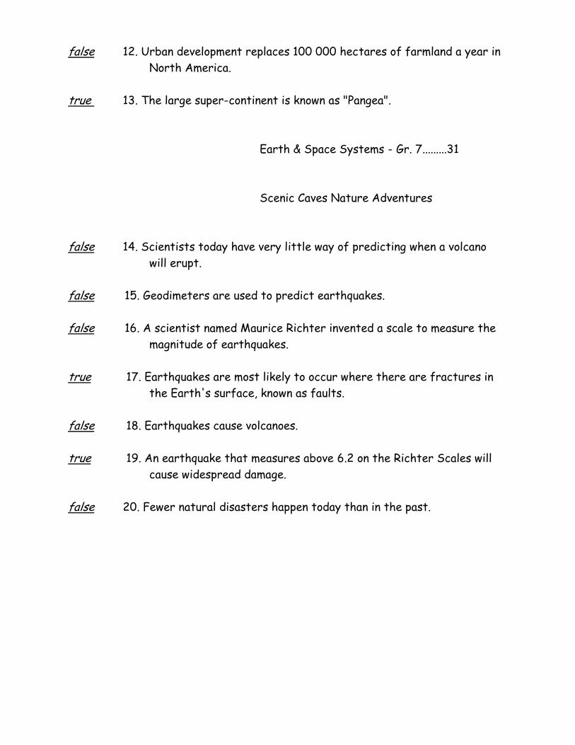
Earth & Space Systems - Gr. 7.........31
Scenic Caves Nature Adventures
false 14. Scientists today have very little way of predicting when a volcano
will erupt.
false 15. Geodimeters are used to predict earthquakes.
false 16. A scientist named Maurice Richter invented a scale to measure the
magnitude of earthquakes.
true 17. Earthquakes are most likely to occur where there are fractures in
the Earth's surface, known as faults.
false 18. Earthquakes cause volcanoes.
true 19. An earthquake that measures above 6.2 on the Richter Scales will
cause widespread damage.
false 20. Fewer natural disasters happen today than in the past.