Embed Size (px)
Citation preview
SDSC ProjectsSDSC Projects
• Part 1: BUILDING PRESERVATION ENVIRONMENTS (Reagan Moore, [email protected])• Storage Resource Broker (SRB) and collection migration
technologies:• Name space management for resources, users, files, metadata,
constraints• Bulk import of metadata and registration of files directly from file systems• Bulk registration of SRB collections into the DSpace technology
• Goals: understanding mechanisms used to support federation/migration for geodata; understanding collection description sufficient for migration onto supporting infrastructure
• Part 2: SOME GIS DATA ARCHIVING PROJECTS (Ilya Zaslavsky, [email protected])• Archiving spatial data /NARA projects• A few recent NHPRC or InterPARES supported projects: Maine
GeoArchives, VanMap
PreservationPreservation
• Archival processes through which a digital entity is extracted from its creation environment and migrated to a preservation environment, while maintaining authenticity and integrity information.
• Extraction process requires insertion of support infrastructure underneath the digital material, characterization of the authenticity and integrity, characterization of the digital encoding format, and characterization of the display operations
• Goal is infrastructure independence, the ability to use any commercial storage system, database, or access mechanism
Preservation CommunitiesPreservation Communities
• InterPARES - diplomatics• Preservation of records• Focus: provenance, authenticity, integrity
• NARA• Preservation of records from federal agencies• Focus: infrastructure independence, scalability
• State archives• Preservation of submitted “collections”• Focus: automation of archival processes
Preservation StrategiesPreservation Strategies
• Emulation• Migrate the display application onto new operating
systems• Equivalent to forcing use of candlelight to look at 16th
century documents
• Transformative migration• Migrate the encoding format to the new standard• Migration period is expected to be 5-10 years
• Persistent object• Characterize the encoding format• Migrate the characterization forward in time
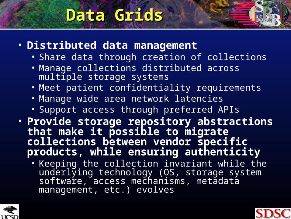
Data GridsData Grids
• Distributed data management• Share data through creation of collections• Manage collections distributed across multiple storage
systems• Meet patient confidentiality requirements• Manage wide area network latencies• Support access through preferred APIs
• Provide storage repository abstractions that make it possible to migrate collections between vendor specific products, while ensuring authenticity• Keeping the collection invariant while the underlying
technology (OS, storage system software, access mechanisms, metadata management, etc.) evolves
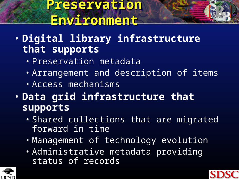
Preservation EnvironmentPreservation Environment
• Digital library infrastructure that supports• Preservation metadata• Arrangement and description of items• Access mechanisms
• Data grid infrastructure that supports• Shared collections that are migrated forward in
time• Management of technology evolution• Administrative metadata providing status of
records
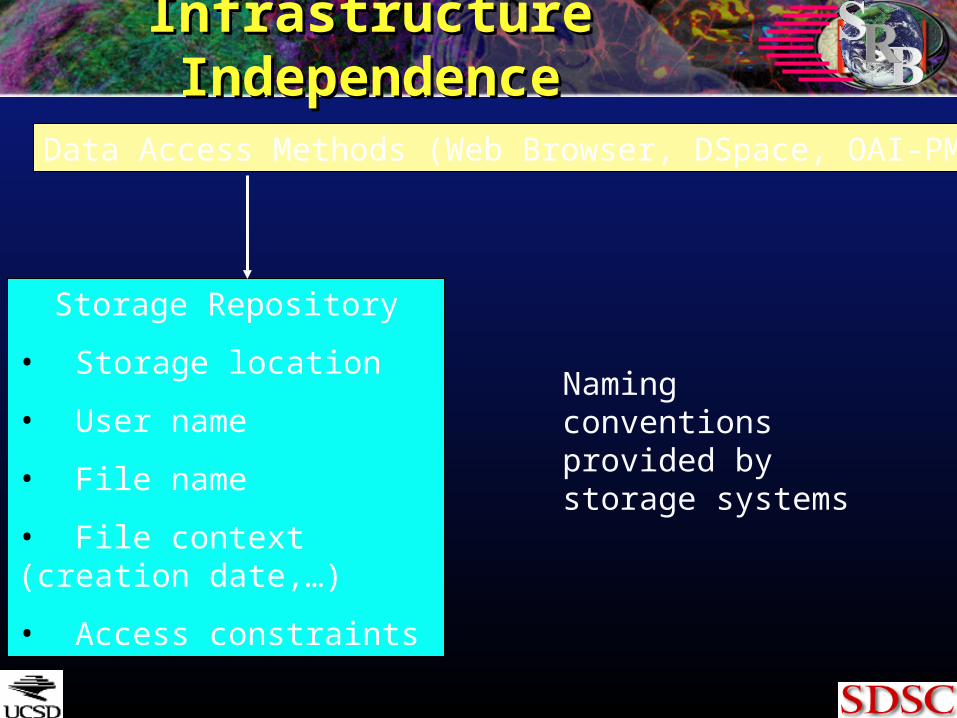
Infrastructure IndependenceInfrastructure Independence
Storage Repository
• Storage location
• User name
• File name
• File context (creation date,…)
• Access constraints
Data Access Methods (Web Browser, DSpace, OAI-PMH)
Naming conventions provided by storage systems
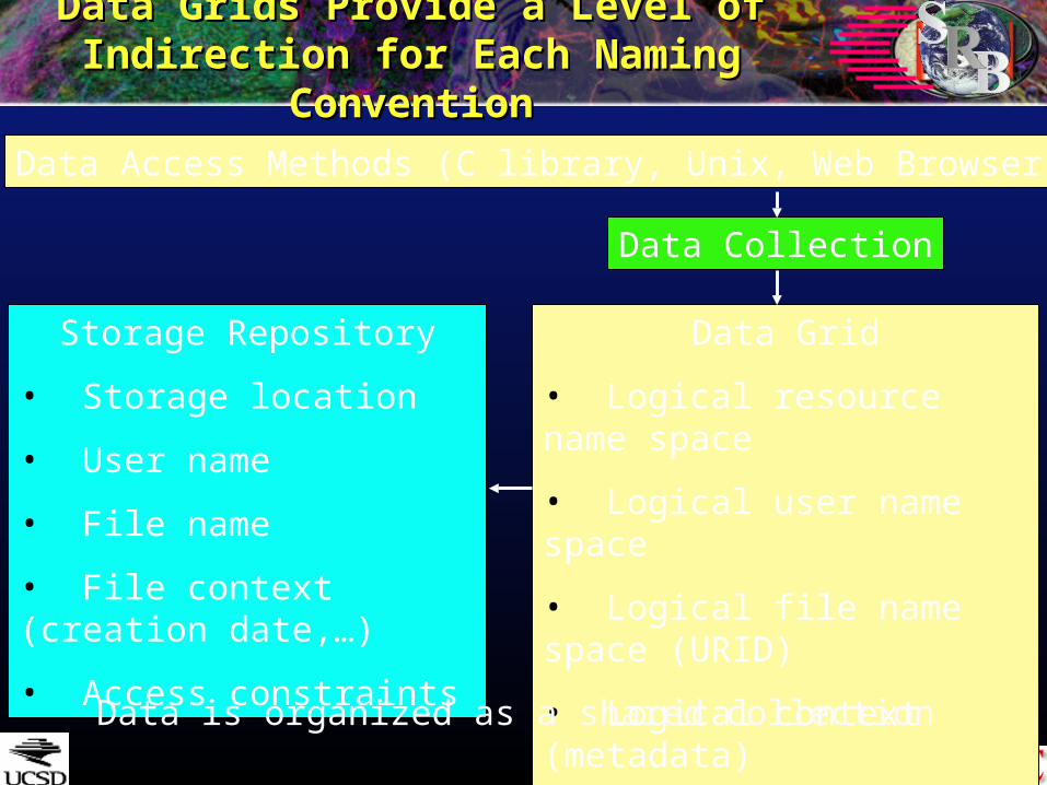
Data Grids Provide a Level of Indirection Data Grids Provide a Level of Indirection for Each Naming Conventionfor Each Naming Convention
Storage Repository
• Storage location
• User name
• File name
• File context (creation date,…)
• Access constraints
Data Grid
• Logical resource name space
• Logical user name space
• Logical file name space (URID)
• Logical context (metadata)
• Control/consistency constraints
Data Collection
Data Access Methods (C library, Unix, Web Browser)
Data is organized as a shared collection
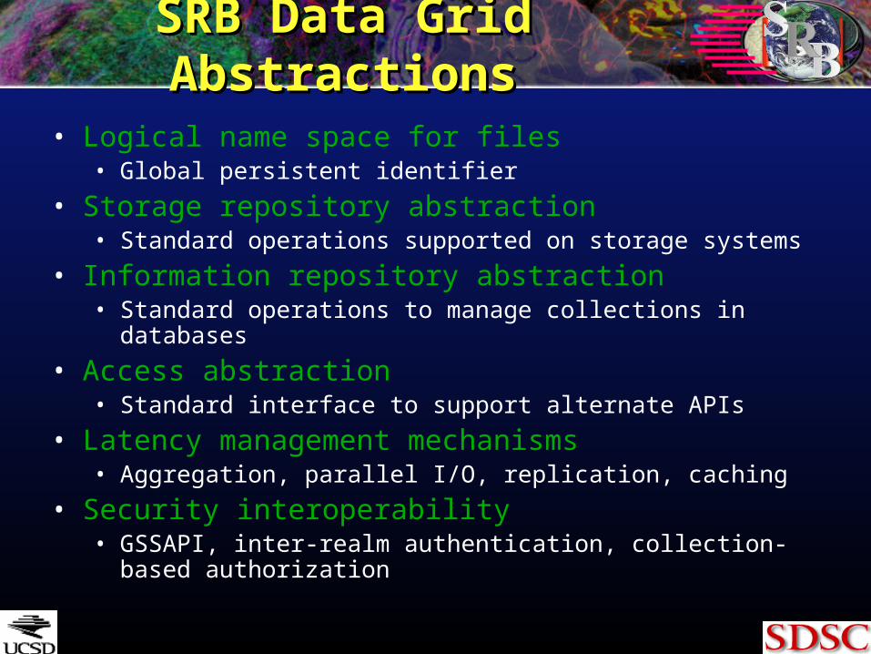
SRB Data Grid AbstractionsSRB Data Grid Abstractions
• Logical name space for files• Global persistent identifier
• Storage repository abstraction• Standard operations supported on storage systems
• Information repository abstraction• Standard operations to manage collections in databases
• Access abstraction• Standard interface to support alternate APIs
• Latency management mechanisms• Aggregation, parallel I/O, replication, caching
• Security interoperability• GSSAPI, inter-realm authentication, collection-based
authorization
Unix Shell
NT Browser,Kepler Actors
OAI,WSDL,(WSRF)
HTTP,DSpace,
OpenDAP,GridFTP
Archives - Tape,Sam-QFS, DMF,
HPSS, ADSM,UniTree, ADS
Databases -DB2, Oracle,
Sybase, Postgres, mySQL, Informix
File SystemsUnix, NT,Mac OSX
Application
ORB
Storage Repository AbstractionDatabase Abstraction
Databases -DB2, Oracle, Sybase,
Postgres, mySQL,Informix
CLibrary,
Java
Logical Name Space
LatencyManagement
DataTransport
MetadataTransport
Consistency & Metadata Management / Authorization, Authentication, Audit
Linux I/OC++
DLL /Python,
Perl, Windows
Federation Management
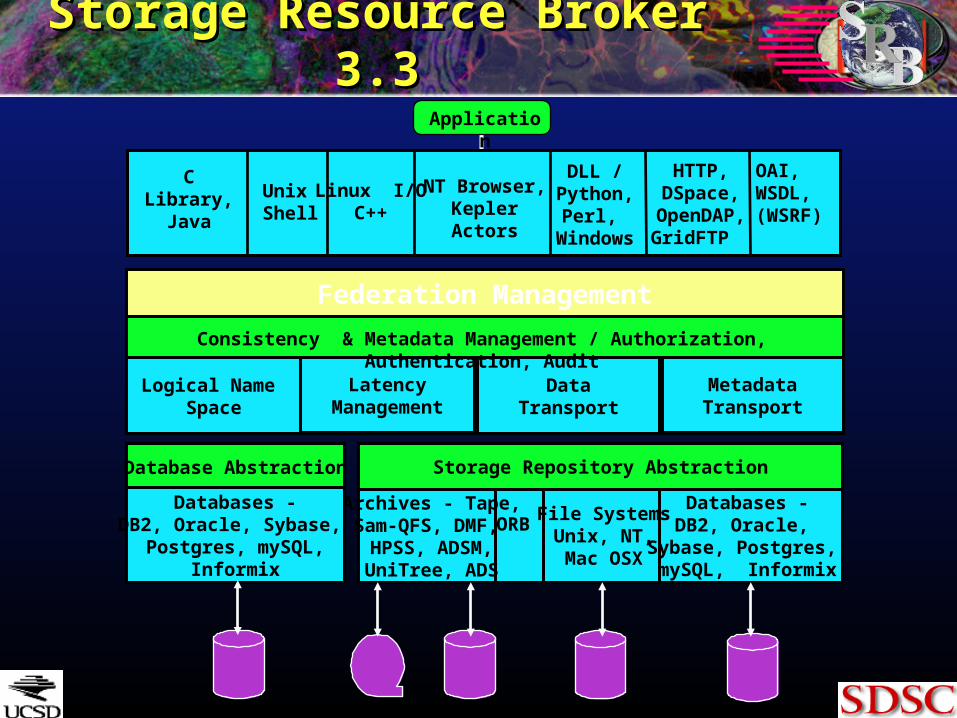
Storage Resource Broker 3.3Storage Resource Broker 3.3
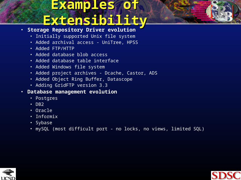
Examples of ExtensibilityExamples of Extensibility• Storage Repository Driver evolution
• Initially supported Unix file system• Added archival access - UniTree, HPSS• Added FTP/HTTP• Added database blob access• Added database table interface• Added Windows file system• Added project archives - Dcache, Castor, ADS• Added Object Ring Buffer, Datascope• Adding GridFTP version 3.3
• Database management evolution• Postgres• DB2• Oracle• Informix• Sybase• mySQL (most difficult port - no locks, no views, limited SQL)
Examples of ExtensibilityExamples of Extensibility
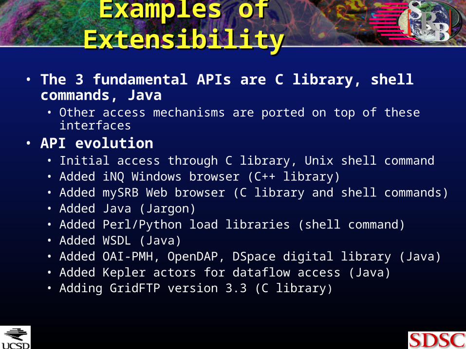
• The 3 fundamental APIs are C library, shell commands, Java• Other access mechanisms are ported on top of these interfaces
• API evolution• Initial access through C library, Unix shell command• Added iNQ Windows browser (C++ library)• Added mySRB Web browser (C library and shell commands)• Added Java (Jargon)• Added Perl/Python load libraries (shell command)• Added WSDL (Java)• Added OAI-PMH, OpenDAP, DSpace digital library (Java)• Added Kepler actors for dataflow access (Java)• Adding GridFTP version 3.3 (C library)
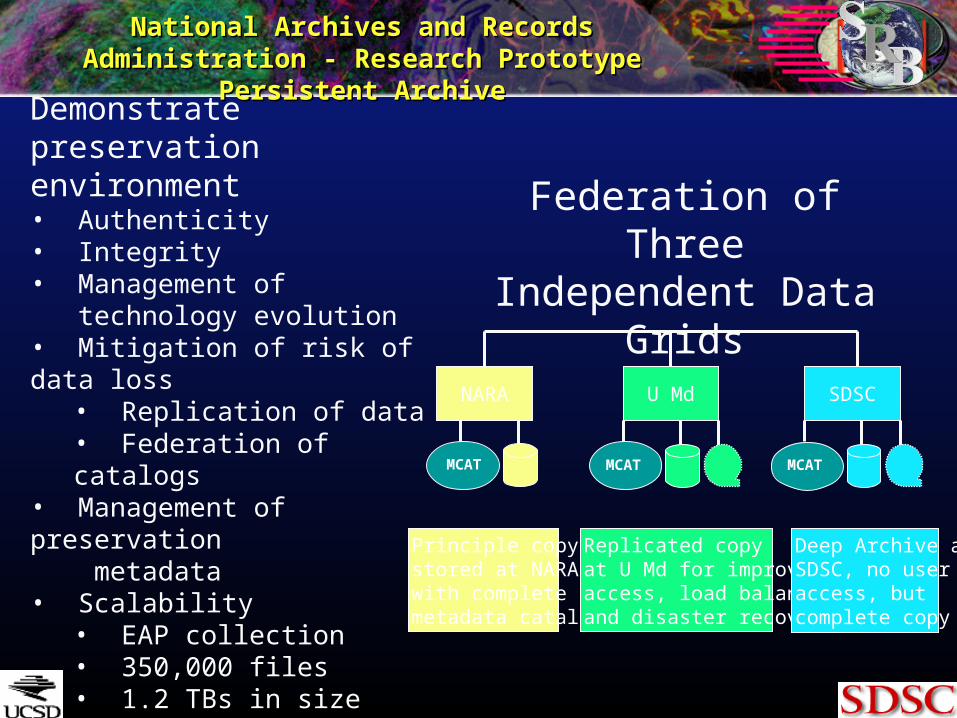
National Archives and Records Administration - National Archives and Records Administration - Research Prototype Persistent ArchiveResearch Prototype Persistent Archive
NARA U Md SDSC
MCAT MCAT MCAT
Principle copystored at NARAwith completemetadata catalog
Replicated copyat U Md for improvedaccess, load balancingand disaster recovery
Deep Archive atSDSC, no useraccess, but complete copy
Demonstrate preservation environment • Authenticity• Integrity• Management of technology evolution• Mitigation of risk of data loss
• Replication of data• Federation of catalogs
• Management of preservation metadata• Scalability
• EAP collection• 350,000 files• 1.2 TBs in size
Federation of Three Independent Data Grids
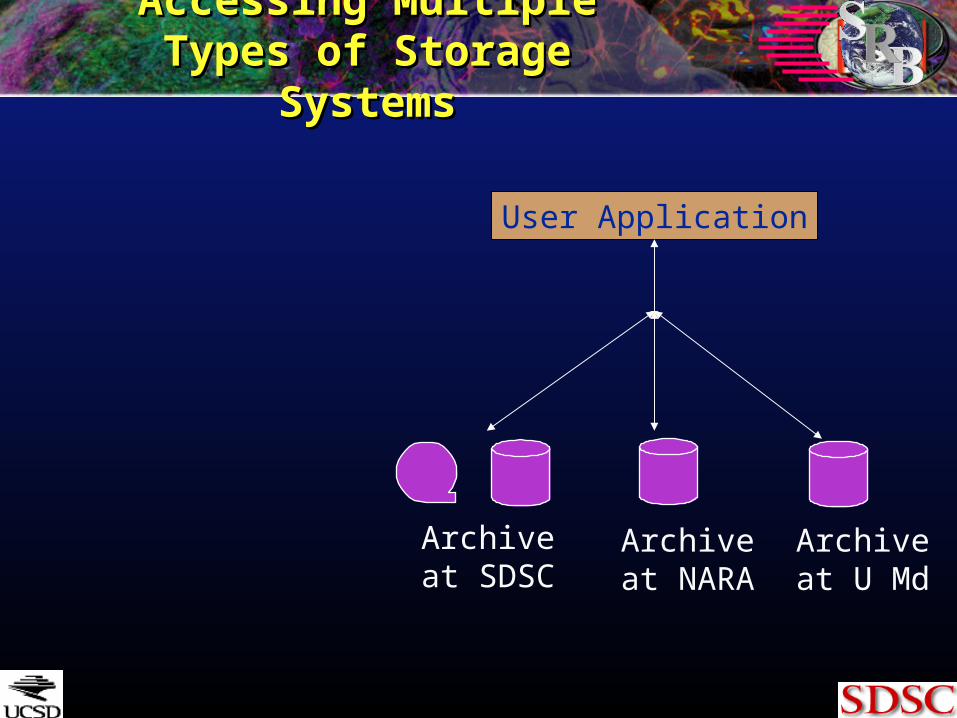
Accessing Multiple Types of Accessing Multiple Types of Storage SystemsStorage Systems
User Application
Archiveat SDSC
Archiveat NARA
Archiveat U Md
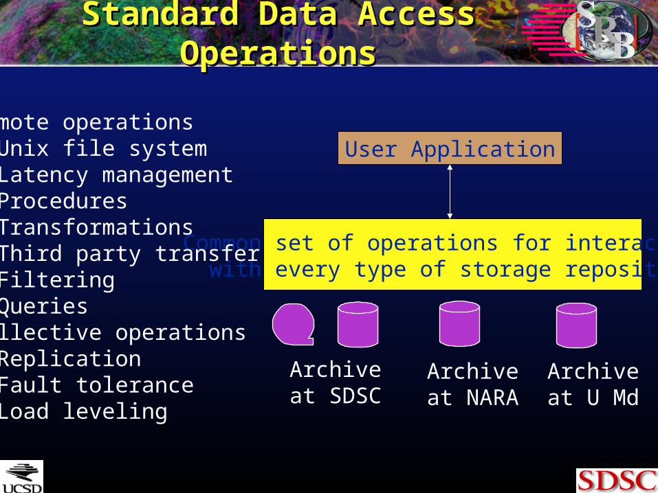
Standard Data Access OperationsStandard Data Access Operations
Common set of operations for interacting with every type of storage repository
User ApplicationRemote operations Unix file system Latency management Procedures Transformations Third party transfer Filtering QueriesCollective operations Replication Fault tolerance Load leveling
Archiveat SDSC
Archiveat NARA
Archiveat U Md
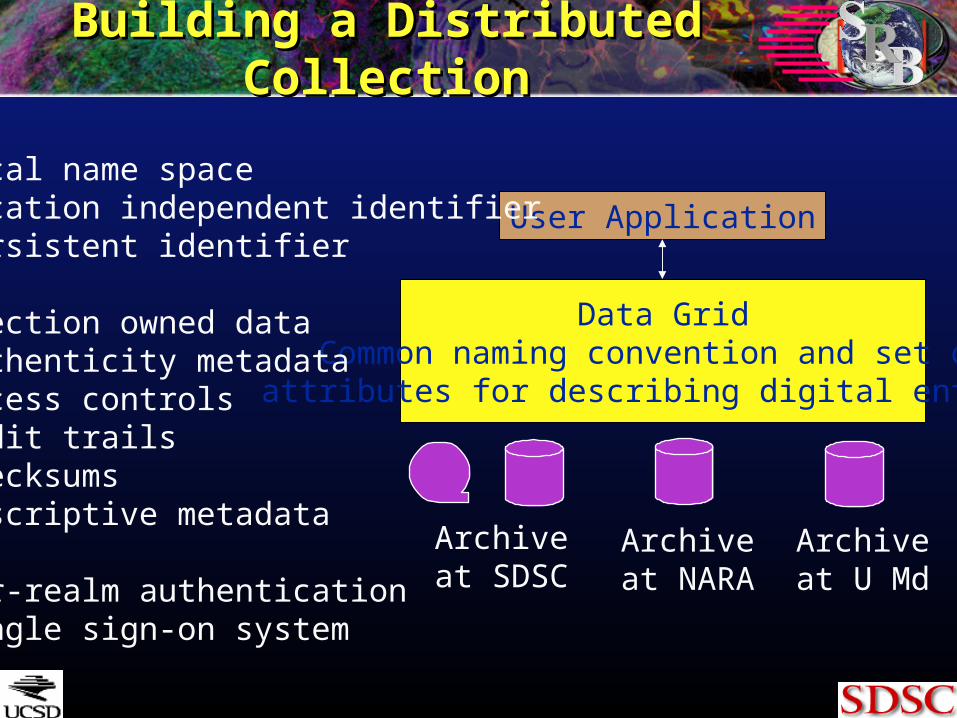
Building a Distributed CollectionBuilding a Distributed Collection
Archiveat SDSC
Data GridCommon naming convention and set of attributes for describing digital entities
User Application
Logical name space Location independent identifier Persistent identifier Collection owned data Authenticity metadata Access controls Audit trails Checksums Descriptive metadata
Inter-realm authentication Single sign-on system
Archiveat NARA
Archiveat U Md
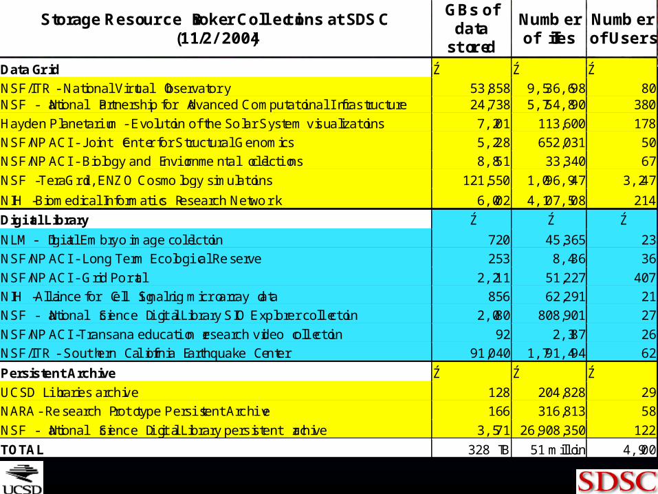
Storage Resource Broker Collections at SDSC(11/2/2004)
GBs ofdata
stored
Numberof files
Numberof Users
Data Grid Ź Ź Ź
NSF/ITR - National Virtual Observatory 53,858 9,536,698 80NSF - National Partnership for Advanced Computational Infrastructure 24,738 5,754,890 380
Hayden Planetarium - Evolution of the Solar System visualizations 7,201 113,600 178
NSF/NPACI - Joint Center for Structural Genomics 5,228 652,031 50
NSF/NPACI - Biology and Environmental collections 8,851 33,340 67
NSF - TeraGrid, ENZO Cosmology simulations 121,550 1,096,947 3,247
NIH - Biomedical Informatics Research Network 6,002 4,107,508 214
Digital Library Ź Ź Ź
NLM - Digital Embryo image collection 720 45,365 23
NSF/NPACI - Long Term Ecological Reserve 253 8,436 36
NSF/NPACI - Grid Portal 2,211 51,227 407
NIH - Alliance for Cell Signaling microarray data 856 62,291 21
NSF - National Science Digital Library SIO Explorer collection 2,080 808,901 27
NSF/NPACI -Transana education research video collection 92 2,387 26
NSF/ITR - Southern California Earthquake Center 91,040 1,791,494 62
Persistent Archive Ź Ź Ź
UCSD Libraries archive 128 204,828 29
NARA- Research Prototype Persistent Archive 166 316,813 58
NSF - National Science Digital Library persistent archive 3,571 26,908,350 122
TOTAL 328 TB 51 million 4,900
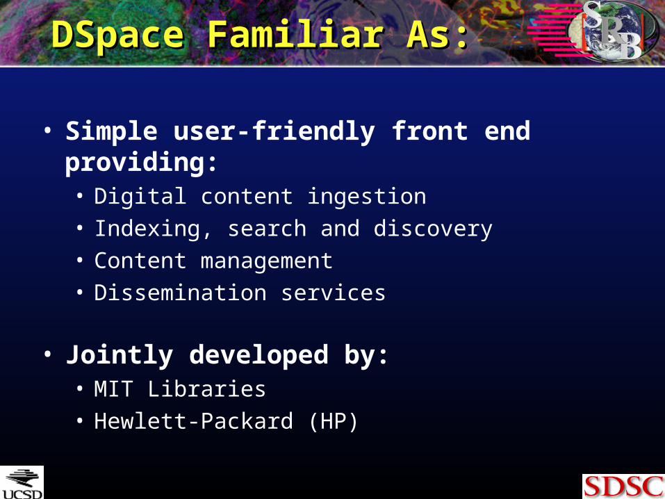
DSpace Familiar As:DSpace Familiar As:
• Simple user-friendly front end providing:• Digital content ingestion• Indexing, search and discovery• Content management• Dissemination services
• Jointly developed by:• MIT Libraries• Hewlett-Packard (HP)
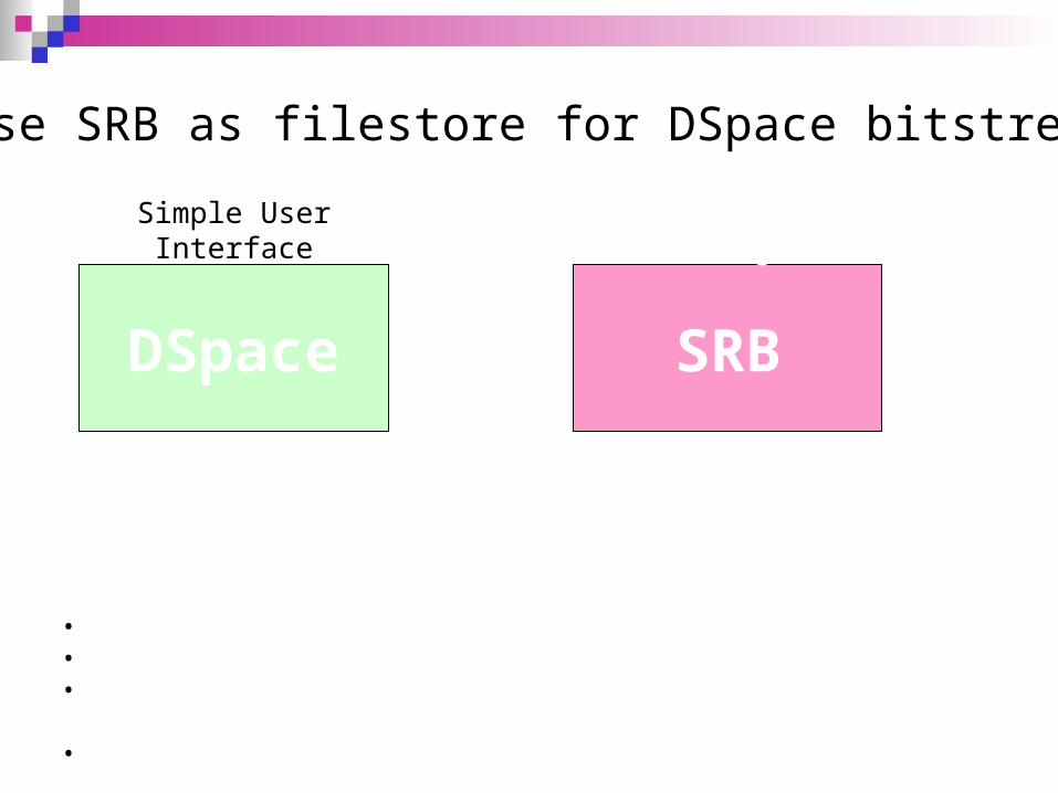
Simple User Interface
DSpace SRB+
“Unlimited” Storage
Uniform interface to storage Distributed Heterogeneous
Content Ingestion Discovery Dissemination
Use SRB as filestore for DSpace bitstreams
STEPS:•Replace DSpace file system calls with SRB access calls•Employ METS based Archival Information Package (AIP)•Enable exchange of data and metadata between independent DSpace and SRB systems•Validate authenticity of exchanged content
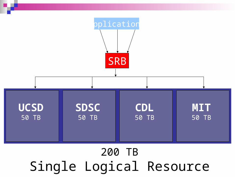
200 TB
Single Logical Resource
UCSD50 TB
SDSC50 TB
CDL50 TB
MIT50 TB
SRB
Applications
San Diego Supercomputer Center
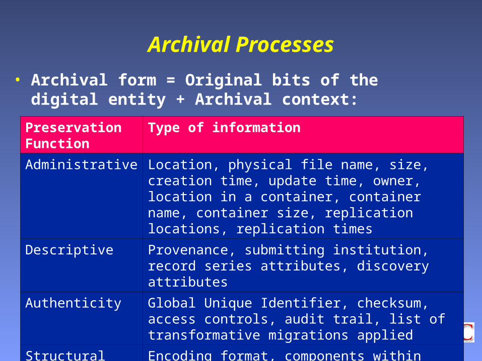
Archival Processes
• Archival form = Original bits of the digital entity + Archival context:
Preservation Function
Type of information
Administrative Location, physical file name, size, creation time, update time, owner, location in a container, container name, container size, replication locations, replication times
Descriptive Provenance, submitting institution, record series attributes, discovery attributes
Authenticity Global Unique Identifier, checksum, access controls, audit trail, list of transformative migrations applied
Structural Encoding format, components within digital entity
Behavioral Viewing mechanisms, manipulation mechanisms
San Diego Supercomputer Center
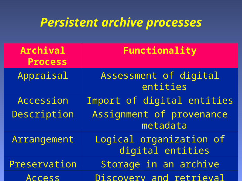
Persistent archive processes
Archival Process Functionality
Appraisal Assessment of digital entities
Accession Import of digital entities
Description Assignment of provenance metadata
Arrangement Logical organization of digital entities
Preservation Storage in an archive
Access Discovery and retrieval
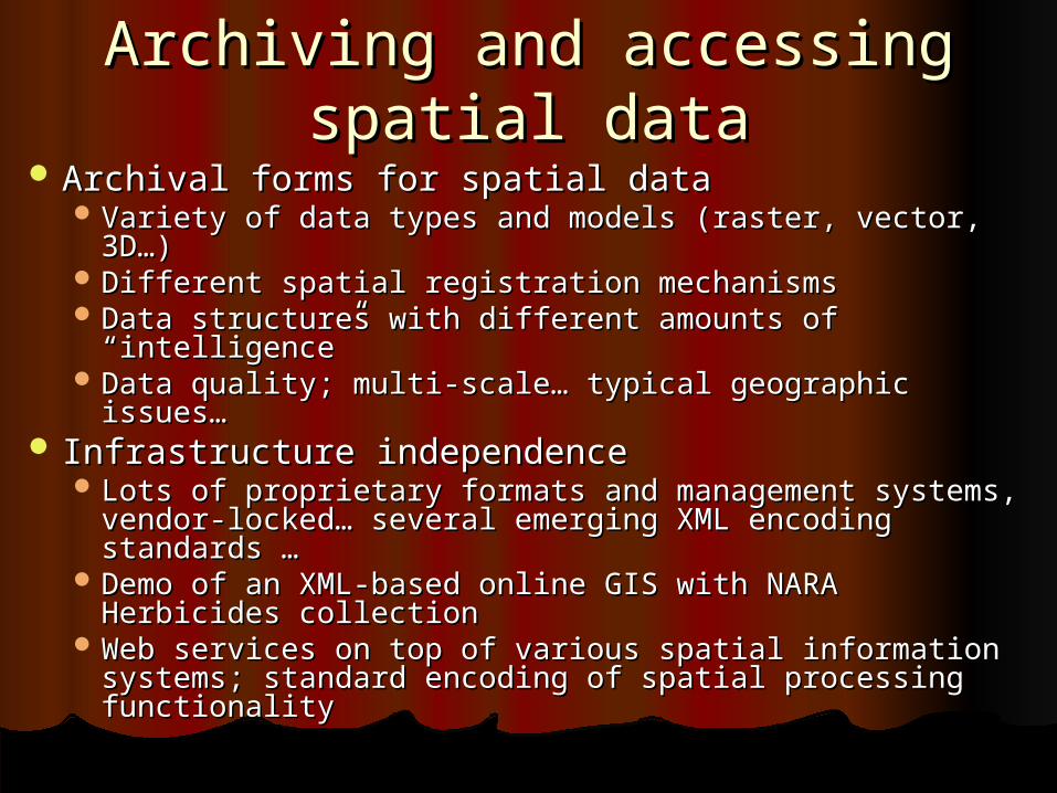
Archiving and accessing spatial Archiving and accessing spatial datadata
Archival forms for spatial dataArchival forms for spatial data Variety of data types and models (raster, vector, 3D…)Variety of data types and models (raster, vector, 3D…) Different spatial registration mechanismsDifferent spatial registration mechanisms Data structures with different amounts of “intelligence”Data structures with different amounts of “intelligence” Data quality; multi-scale… typical geographic issues…Data quality; multi-scale… typical geographic issues…
Infrastructure independenceInfrastructure independence Lots of proprietary formats and management systems, Lots of proprietary formats and management systems,
vendor-locked… several emerging XML encoding vendor-locked… several emerging XML encoding standards …standards …
Demo of an XML-based online GIS with NARA Herbicides Demo of an XML-based online GIS with NARA Herbicides collectioncollection
Web services on top of various spatial information Web services on top of various spatial information systems; standard encoding of spatial processing systems; standard encoding of spatial processing functionalityfunctionality
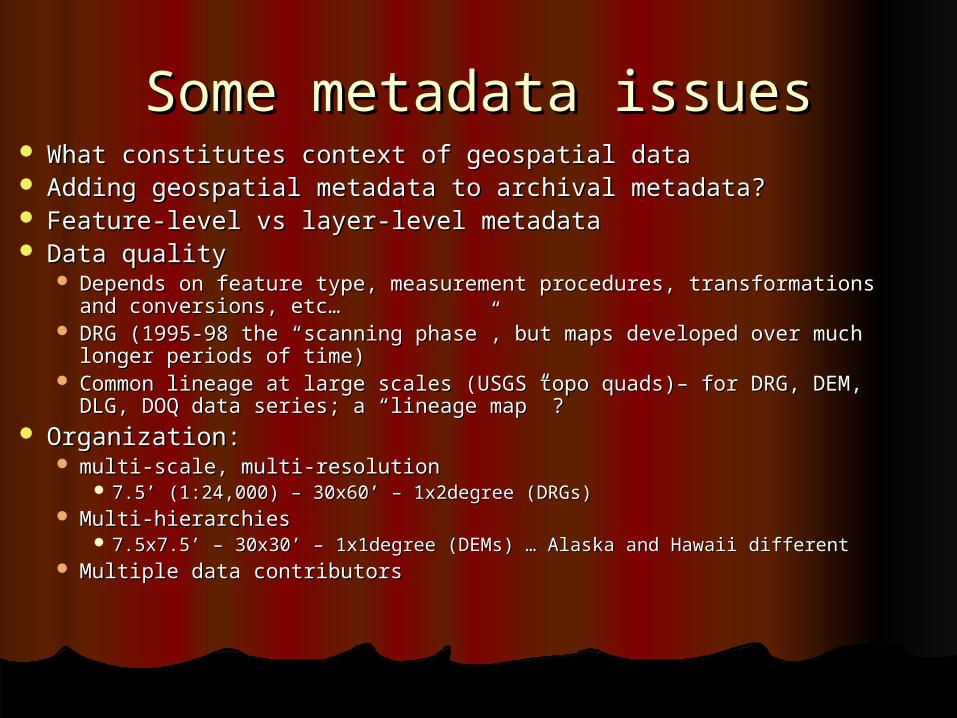
Some metadata issuesSome metadata issues What constitutes context of geospatial dataWhat constitutes context of geospatial data Adding geospatial metadata to archival metadata?Adding geospatial metadata to archival metadata? Feature-level vs layer-level metadataFeature-level vs layer-level metadata Data qualityData quality
Depends on feature type, measurement procedures, transformations and Depends on feature type, measurement procedures, transformations and conversions, etc…conversions, etc…
DRG (1995-98 the “scanning phase”, but maps developed over much longer DRG (1995-98 the “scanning phase”, but maps developed over much longer periods of time)periods of time)
Common lineage at large scales (USGS topo quads)– for DRG, DEM, DLG, DOQ Common lineage at large scales (USGS topo quads)– for DRG, DEM, DLG, DOQ data series; a “lineage map” ?data series; a “lineage map” ?
Organization: Organization: multi-scale, multi-resolutionmulti-scale, multi-resolution
7.5’ (1:24,000) – 30x60’ – 1x2degree (DRGs)7.5’ (1:24,000) – 30x60’ – 1x2degree (DRGs) Multi-hierarchiesMulti-hierarchies
7.5x7.5’ – 30x30’ – 1x1degree (DEMs) … Alaska and Hawaii different7.5x7.5’ – 30x30’ – 1x1degree (DEMs) … Alaska and Hawaii different Multiple data contributorsMultiple data contributors
25
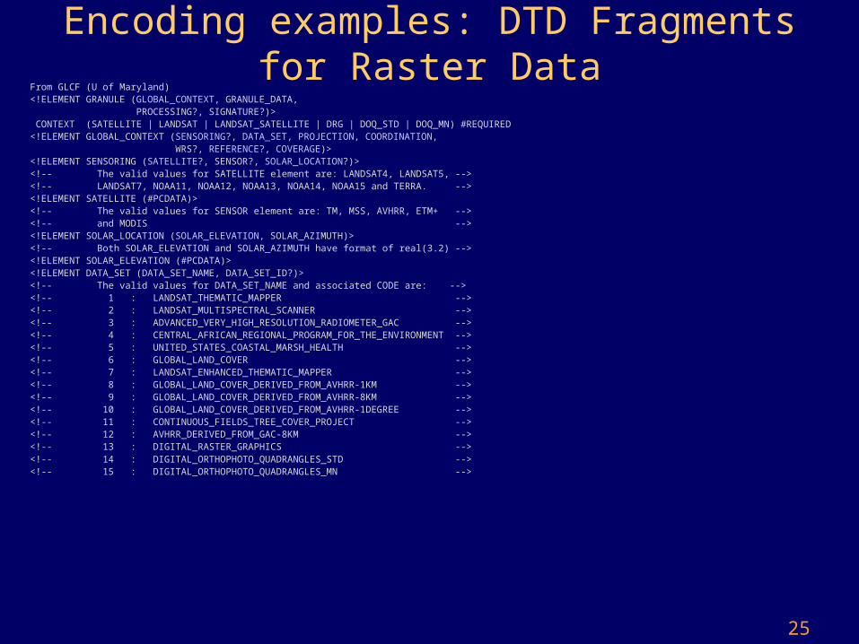
Encoding examples: DTD Fragments for Raster Data
From GLCF (U of Maryland)<!ELEMENT GRANULE (GLOBAL_CONTEXT, GRANULE_DATA, PROCESSING?, SIGNATURE?)> CONTEXT (SATELLITE | LANDSAT | LANDSAT_SATELLITE | DRG | DOQ_STD | DOQ_MN) #REQUIRED<!ELEMENT GLOBAL_CONTEXT (SENSORING?, DATA_SET, PROJECTION, COORDINATION, WRS?, REFERENCE?, COVERAGE)><!ELEMENT SENSORING (SATELLITE?, SENSOR?, SOLAR_LOCATION?)><!-- The valid values for SATELLITE element are: LANDSAT4, LANDSAT5, --><!-- LANDSAT7, NOAA11, NOAA12, NOAA13, NOAA14, NOAA15 and TERRA. --><!ELEMENT SATELLITE (#PCDATA)><!-- The valid values for SENSOR element are: TM, MSS, AVHRR, ETM+ --><!-- and MODIS --><!ELEMENT SOLAR_LOCATION (SOLAR_ELEVATION, SOLAR_AZIMUTH)><!-- Both SOLAR_ELEVATION and SOLAR_AZIMUTH have format of real(3.2) --> <!ELEMENT SOLAR_ELEVATION (#PCDATA)><!ELEMENT DATA_SET (DATA_SET_NAME, DATA_SET_ID?)><!-- The valid values for DATA_SET_NAME and associated CODE are: --><!-- 1 : LANDSAT_THEMATIC_MAPPER --><!-- 2 : LANDSAT_MULTISPECTRAL_SCANNER --><!-- 3 : ADVANCED_VERY_HIGH_RESOLUTION_RADIOMETER_GAC --><!-- 4 : CENTRAL_AFRICAN_REGIONAL_PROGRAM_FOR_THE_ENVIRONMENT --><!-- 5 : UNITED_STATES_COASTAL_MARSH_HEALTH --><!-- 6 : GLOBAL_LAND_COVER --><!-- 7 : LANDSAT_ENHANCED_THEMATIC_MAPPER --><!-- 8 : GLOBAL_LAND_COVER_DERIVED_FROM_AVHRR-1KM --><!-- 9 : GLOBAL_LAND_COVER_DERIVED_FROM_AVHRR-8KM --><!-- 10 : GLOBAL_LAND_COVER_DERIVED_FROM_AVHRR-1DEGREE --><!-- 11 : CONTINUOUS_FIELDS_TREE_COVER_PROJECT --><!-- 12 : AVHRR_DERIVED_FROM_GAC-8KM --><!-- 13 : DIGITAL_RASTER_GRAPHICS --><!-- 14 : DIGITAL_ORTHOPHOTO_QUADRANGLES_STD --><!-- 15 : DIGITAL_ORTHOPHOTO_QUADRANGLES_MN -->
26
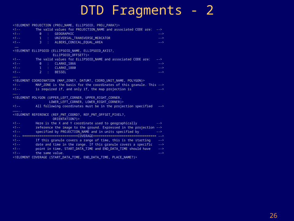
DTD Fragments - 2<!ELEMENT PROJECTION (PROJ_NAME, ELLIPSOID, PROJ_PARA?)><!-- The valid values for PROJECTION_NAME and associated CODE are: --><!-- 0 : GEOGRAPHIC --><!-- 1 : UNIVERSAL_TRANSVERSE_MERCATOR --><!-- 3 : ALBERS_CONICAL_EQUAL_AREA --> ……<!ELEMENT ELLIPSOID (ELLIPSOID_NAME, ELLIPSOID_AXIS?, ELLIPSOID_OFFSET?)><!-- The valid values for ELLIPSOID_NAME and associated CODE are: --><!-- 0 : CLARKE_1866 --><!-- 1 : CLARKE_1880 --><!-- 2 : BESSEL -->……..<!ELEMENT COORDINATION (MAP_ZONE?, DATUM?, COORD_UNIT_NAME, POLYGON)><!-- MAP_ZONE is the basis for the coordinates of this granule. This --><!-- is required if, and only if, the map projection is -->……..<!ELEMENT POLYGON (UPPER_LEFT_CORNER, UPPER_RIGHT_CORNER, LOWER_LEFT_CORNER, LOWER_RIGHT_CORNER)><!-- All following coordinates must be in the projection specified -->………..<!ELEMENT REFERENCE (REF_PNT_COORD?, REF_PNT_OFFSET_PIXEL?, ORIENTATION?)><!-- Here is the X and Y coordinate used to geographically --><!-- reference the image to the ground. Expressed in the projection --><!-- specified by PROJECTION_NAME and in units specified by --><!-- =============================COVERAGE================================= --> <!-- If this granule covers a range of time, this is the starting --><!-- date and time in the range. If this granule covers a specific --><!-- point in time, START_DATA_TIME and END_DATA_TIME should have --><!-- the same value. --> <!ELEMENT COVERAGE (START_DATA_TIME, END_DATA_TIME, PLACE_NAME?)>
27
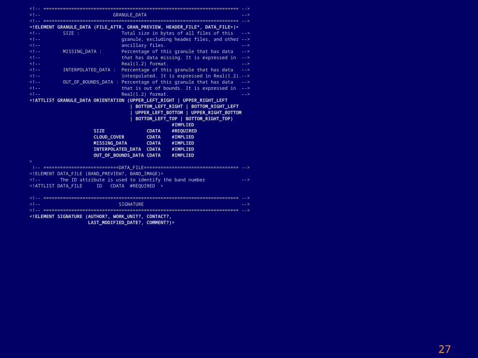
<!-- ====================================================================== --><!-- GRANULE_DATA --><!-- ====================================================================== --><!ELEMENT GRANULE_DATA (FILE_ATTR, GRAN_PREVIEW, HEADER_FILE*, DATA_FILE+)><!-- SIZE : Total size in bytes of all files of this --><!-- granule, excluding header files, and other --><!-- ancillary files. --><!-- MISSING_DATA : Percentage of this granule that has data --><!-- that has data missing. It is expressed in --><!-- Real(1.2) format. --><!-- INTERPOLATED_DATA : Percentage of this granule that has data --><!-- interpolated. It is expressed in Real(1.2).--><!-- OUT_OF_BOUNDS_DATA : Percentage of this granule that has data --><!-- that is out of bounds. It is expressed in --><!-- Real(1.2) format. --><!ATTLIST GRANULE_DATA ORIENTATION (UPPER_LEFT_RIGHT | UPPER_RIGHT_LEFT | BOTTOM_LEFT_RIGHT | BOTTOM_RIGHT_LEFT | UPPER_LEFT_BOTTOM | UPPER_RIGHT_BOTTOM | BOTTOM_LEFT_TOP | BOTTOM_RIGHT_TOP) #IMPLIED SIZE CDATA #REQUIRED CLOUD_COVER CDATA #IMPLIED MISSING_DATA CDATA #IMPLIED INTERPOLATED_DATA CDATA #IMPLIED OUT_OF_BOUNDS_DATA CDATA #IMPLIED> !-- ===========================DATA_FILE================================== --><!ELEMENT DATA_FILE (BAND_PREVIEW?, BAND_IMAGE)><!-- The ID attribute is used to identify the band number --><!ATTLIST DATA_FILE ID CDATA #REQUIRED > <!-- ====================================================================== --><!-- SIGNATURE --><!-- ====================================================================== --><!ELEMENT SIGNATURE (AUTHOR?, WORK_UNIT?, CONTACT?, LAST_MODIFIED_DATE?, COMMENT?)>
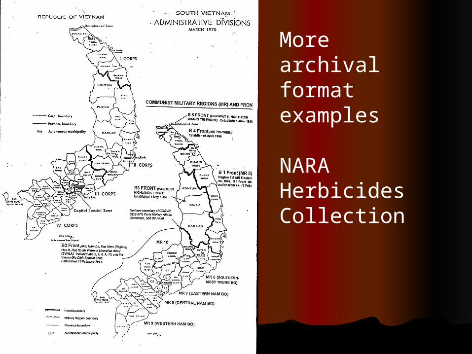
More archival format examples
NARA Herbicides Collection
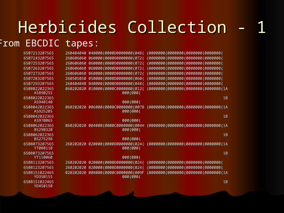
Herbicides Collection - 1Herbicides Collection - 16507213207565 260404040 040000{0000D0000000{048{ {0000000{0000000{0000000{0000000{6507213207565 260404040 040000{0000D0000000{048{ {0000000{0000000{0000000{0000000{6507243207565 260606060 060000{0000D0000000{072{ {0000000{0000000{0000000{0000000{6507243207565 260606060 060000{0000D0000000{072{ {0000000{0000000{0000000{0000000{6507253207565 260606060 060000{0000D0000000{072{ {0000000{0000000{0000000{0000000{6507253207565 260606060 060000{0000D0000000{072{ {0000000{0000000{0000000{0000000{6507263207565 260606060 060000{0000D0000000{072{ {0000000{0000000{0000000{0000000{6507263207565 260606060 060000{0000D0000000{072{ {0000000{0000000{0000000{0000000{6507273207565 260606060 060000{0000D0000000{072{ {0000000{0000000{0000000{0000000{6507273207565 260606060 060000{0000D0000000{072{ {0000000{0000000{0000000{0000000{6507283207565 260505050 050000{0000D0000000{060{ {0000000{0000000{0000000{0000000{6507283207565 260505050 050000{0000D0000000{060{ {0000000{0000000{0000000{0000000{6507293207565 260404040 040000{0000D0000000{048{ {0000000{0000000{0000000{0000000{6507293207565 260404040 040000{0000D0000000{048{ {0000000{0000000{0000000{0000000{6508022022365 060202020 010000{0000C0000000{012{ {0000000{0000000{0000000{0000000{1A 6508022022365 060202020 010000{0000C0000000{012{ {0000000{0000000{0000000{0000000{1A
AS890255 000{000{AS890255 000{000{6508022022365 1B 6508022022365 1B
AS940140 000{000{AS940140 000{000{6508042022365 060202020 006000{0000C0000000{007B {0000000{0000000{0000000{0000000{1A 6508042022365 060202020 006000{0000C0000000{007B {0000000{0000000{0000000{0000000{1A
AS925205 000{000{AS925205 000{000{6508042022365 1B 6508042022365 1B
AS970065 000{000{AS970065 000{000{6508062022365 060202020 004000{0000C0000000{004H {0000000{0000000{0000000{0000000{1A 6508062022365 060202020 004000{0000C0000000{004H {0000000{0000000{0000000{0000000{1A
BS290320 000{000{BS290320 000{000{6508062022365 1B 6508062022365 1B
BS275298 000{000{BS275298 000{000{6508073207565 260202020 020000{0000D0000000{024{ {0000000{0000000{0000000{0000000{1A 6508073207565 260202020 020000{0000D0000000{024{ {0000000{0000000{0000000{0000000{1A
YT080110 000{000{YT080110 000{000{6508073207565 1B 6508073207565 1B
YT110060 000{000{YT110060 000{000{6508113207565 260202020 020000{0000D0000000{024{ {0000000{0000000{0000000{0000000{6508113207565 260202020 020000{0000D0000000{024{ {0000000{0000000{0000000{0000000{6508123207565 260202020 020000{0000D0000000{024{ {0000000{0000000{0000000{0000000{6508123207565 260202020 020000{0000D0000000{024{ {0000000{0000000{0000000{0000000{6508151022465 020202020 008000{0000C0000000{009F {0000000{0000000{0000000{0000000{1A 6508151022465 020202020 008000{0000C0000000{009F {0000000{0000000{0000000{0000000{1A
YD350155 000{000{YD350155 000{000{6508151022465 1B 6508151022465 1B
YD450150 YD450150
From EBCDIC tapes:
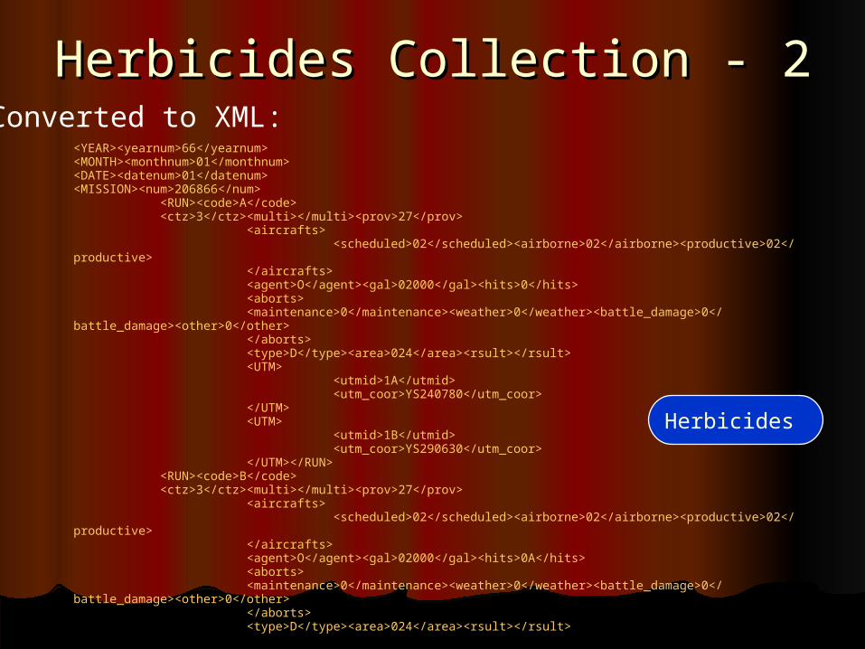
Herbicides Collection - 2Herbicides Collection - 2Converted to XML:
<YEAR><yearnum>66</yearnum><MONTH><monthnum>01</monthnum><DATE><datenum>01</datenum><MISSION><num>206866</num>
<RUN><code>A</code><ctz>3</ctz><multi></multi><prov>27</prov>
<aircrafts><scheduled>02</scheduled><airborne>02</airborne><productive>02</productive>
</aircrafts><agent>O</agent><gal>02000</gal><hits>0</hits><aborts><maintenance>0</maintenance><weather>0</weather><battle_damage>0</battle_damage><other>0</other></aborts><type>D</type><area>024</area><rsult></rsult><UTM>
<utmid>1A</utmid><utm_coor>YS240780</utm_coor>
</UTM><UTM>
<utmid>1B</utmid><utm_coor>YS290630</utm_coor>
</UTM></RUN><RUN><code>B</code><ctz>3</ctz><multi></multi><prov>27</prov>
<aircrafts><scheduled>02</scheduled><airborne>02</airborne><productive>02</productive>
</aircrafts><agent>O</agent><gal>02000</gal><hits>0A</hits><aborts><maintenance>0</maintenance><weather>0</weather><battle_damage>0</battle_damage><other>0</other></aborts><type>D</type><area>024</area><rsult></rsult>
Herbicides
31
Long-term digital records preservation
• National level agenda: – Archives of Australia, UK, NARA– Archival formats for databases, binary data, png
and jpeg, etc., but no specific GIS guidelines (Australia)
• At the state level– Usually GIS preservation policies are not specific
• E.g. Maryland’s GIS preservation policy… mentions lack of standard GIS preservation formats, doesn’t consider frequencies
• Maine GeoArchives project (later…)
32
Database preservation
• A recent ERPANET research report:• Key considerations for database preservation:
– Appraisal should consider the whole information system (purpose, design, context), and costs
– Archive snapshots, or archive data marked for deletion– Defined isolated “archivable” parts in a federated database,
and relationships between them– Archiving data types, check constraints (referential integrity
is critical)– Description is often difficult– Preservation must extract data from their native
environments, while guaranteeing authenticity. Must be automated
– Include access considerations from the start
33
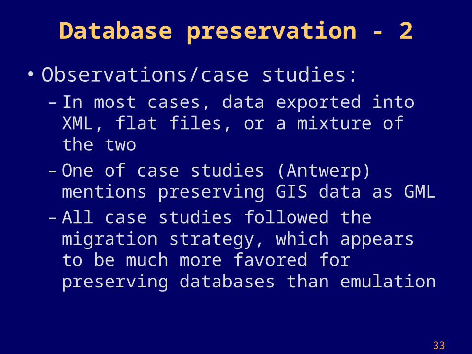
Database preservation - 2
• Observations/case studies:– In most cases, data exported into XML, flat files, or
a mixture of the two– One of case studies (Antwerp) mentions preserving
GIS data as GML– All case studies followed the migration strategy,
which appears to be much more favored for preserving databases than emulation
34
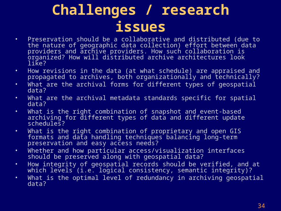
Challenges / research issues• Preservation should be a collaborative and distributed (due to the nature
of geographic data collection) effort between data providers and archive providers. How such collaboration is organized? How will distributed archive architectures look like?
• How revisions in the data (at what schedule) are appraised and propagated to archives, both organizationally and technically?
• What are the archival forms for different types of geospatial data?• What are the archival metadata standards specific for spatial data?• What is the right combination of snapshot and event-based archiving for
different types of data and different update schedules?• What is the right combination of proprietary and open GIS formats and
data handling techniques balancing long-term preservation and easy access needs?
• Whether and how particular access/visualization interfaces should be preserved along with geospatial data?
• How integrity of geospatial records should be verified, and at which levels (i.e. logical consistency, semantic integrity)?
• What is the optimal level of redundancy in archiving geospatial data?
35
tGIS queries
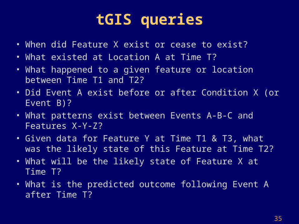
• When did Feature X exist or cease to exist?
• What existed at Location A at Time T?
• What happened to a given feature or location between Time T1 and T2?
• Did Event A exist before or after Condition X (or Event B)?
• What patterns exist between Events A-B-C and Features X-Y-Z?
• Given data for Feature Y at Time T1 & T3, what was the likely state of this Feature at Time T2?
• What will be the likely state of Feature X at Time T?
• What is the predicted outcome following Event A after Time T?
36
Maine GeoArchives
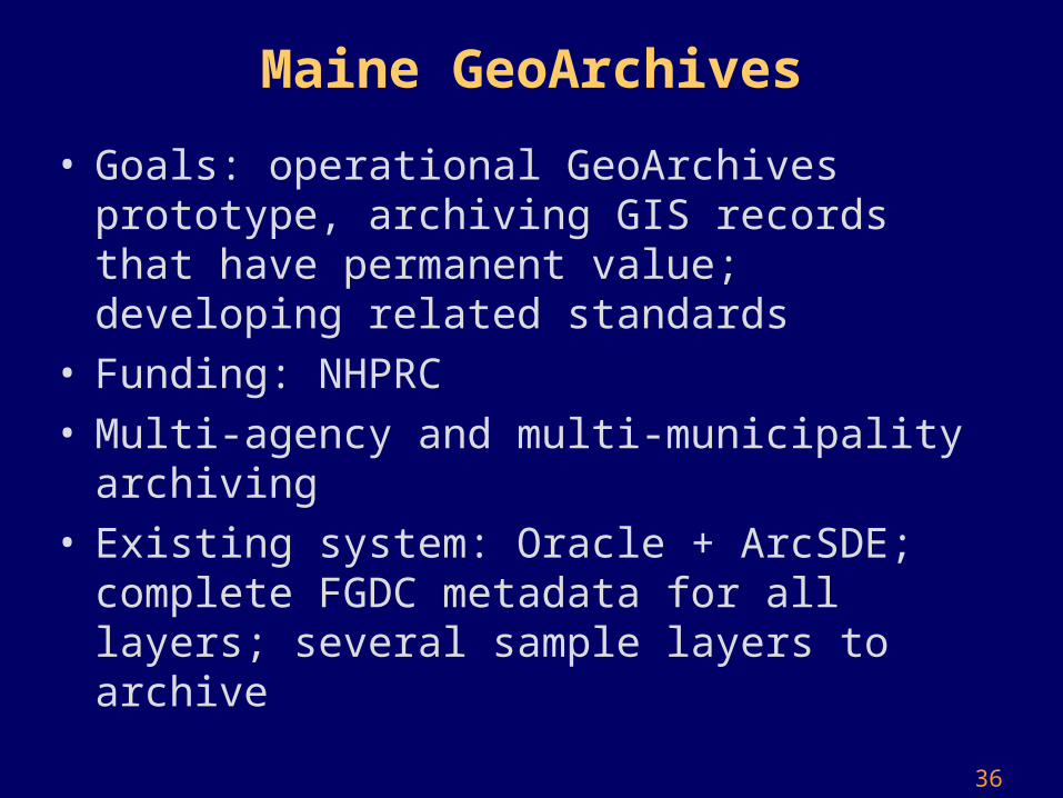
• Goals: operational GeoArchives prototype, archiving GIS records that have permanent value; developing related standards
• Funding: NHPRC• Multi-agency and multi-municipality archiving• Existing system: Oracle + ArcSDE; complete FGDC
metadata for all layers; several sample layers to archive
37
Interesting issues:
• Adequacy of the current model• Archiving frequency (what is expected accuracy)• Feature-level appraisal (“informational value”) and
metadata• Change management• Enhancing archival metadata (with
provenance/lineage, data quality, data types, etc.)• One model doesn’t fit all layers• Archival format• Preserving access mechanisms
38
VanMap
• VanMap: federates information from multiple Vancouver city departments, displays interactive maps (Oracle Spatial, Autodesk map viewer)
• Requirements:– Non-proprietary system for managing GIS data– Ability to import GIS data from a proprietary system into the preservation
environment– Ability to query and display the GIS data in a similar fashion– Ability to archive web pages, “preserve look and feel”– Appraisal mechanism (“information value”?)
• Challenges:– Different update frequencies– Interactive browsing and mapping archived data – Preservation Model: snapshots, recording changes, a hybrid– Retaining relationships between spatial and related report data– What to do with hyperlinks to web pages