Embed Size (px)
Citation preview
Toogood Pond
Terrestrial Biological Inventory and Assessment
February, 2013

Report prepared by: Paul Prior, Fauna Biologist
Gavin Miller, Flora Biologist
Patricia Moleirinho, GIS Technologist
Reviewed by: Sue Hayes, Project Manager, Terrestrial Field
Inventories
Scott Jarvie, Manager, Watershed Monitoring and
Reporting Section
This report may be referenced as:
Toronto and Region Conservation Authority (TRCA). 2013. Toogood
Pond Terrestrial Biological Inventory and Assessment.

T o o g o o d P o n d
February, 2013
i
Table of Contents
p a g e
1.0 Introduction ............................................................................................ 1
1.1 TRCA’s Terrestrial Natural Heritage Program ................................................................. 1
2.0 Study Area Description .......................................................................... 2
3.0 Inventory Methodology ......................................................................... 3
3.1 Landscape Analysis ........................................................................................................ 4
3.2 Vegetation Communities, Flora and Fauna Species ....................................................... 5
4.0 Results and Discussion ......................................................................... 6
4.1 Regional Context ............................................................................................................. 7
4.2 Habitat Patch Findings for the Toogood Pond Study Area ............................................. 7
4.2.1 Quantity of Natural Cover ................................................................................................. 7
4.2.2. Quality Distribution of Natural Cover ................................................................................ 8
4.3 Vegetation Community Findings for the Toogood Pond Study Area.............................. 9
4.3.1 Vegetation Community Representation ........................................................................... 9
4.3.2 Vegetation Communities of Concern ............................................................................. 11
4.4 Flora Findings for the Toogood Pond Study Area ........................................................ 12
4.4.1 Flora Species Representation ........................................................................................ 12
4.4.2 Flora Species of Concern .............................................................................................. 12
4.5 Fauna Species Findings for the Toogood Pond Study Area ....................................... 15
4.5.1 Fauna Species Representation ...................................................................................... 15
4.5.2 Fauna Species of Concern ............................................................................................ 16
5.0 Summary and Recommendations ...................................................... 21
5.1 Site Summary ................................................................................................................ 21
5.2 Site Recommendations ................................................................................................. 22
6.0 References ............................................................................................ 27
T o o g o o d P o n d
February, 2013
ii
p a g e
L is t o f Tab les Table 1: Habitat patch quality, rank and species response ............................................................. 5 Table 2: Schedule of the TRCA biological surveys at the Toogood Pond Study Area ................... 6 Table 3: Summary of Vegetation Communities, Toogood Pond Study Area .................................. 9 Table 4: Summary of Flora Species, Toogood Pond Study Area .................................................. 12 Table 5: Summary of Fauna Species of Concern, Toogood Pond Study Area ............................ 16
L is t o f F igures Figure 1: Toogood Pond: park area and marsh habitat .................................................................... 3 Figure 2: Three wetland communities.............................................................................................. 10 Figure 3: Turtles at Toogood Pond .................................................................................................. 19
L is t o f Maps
Map 1: Toogood Pond Study Area in the Context of Regional Natural Cover ............................ 29
Map 2: Toogood Pond (aerial view) ............................................................................................. 30
Map 3: Regional Natural System Habitat Patch Quality ............................................................... 31
Map 4: Distribution of Fauna Regional Species of Concern ........................................................ 32
Map 5: Habitat Patch Size Scores with Fauna Area Sensitivity Scores ....................................... 33
Map 6: Scores for Matrix Influence and Flora Sensitivity to Development .................................. 34
Map 7: Scores for Matrix Influence and Fauna Sensitivity to Development ................................ 35
Map 8: Habitat Patch Quality ........................................................................................................ 36
Map 9: Vegetation Communities with their Associated Local Ranks ........................................... 37
Map 10: Location of Flora Species of Concern .............................................................................. 38
Map 11: Flora Habitat Dependence Scores ................................................................................... 39
Map 12: Location of Fauna Species of Concern ............................................................................ 40
Map 13: Fauna Species of Concern Habitat Dependence Scores ................................................ 41
List of Appendices Appendix 1: List of Vegetation Communities ................................................................................. 42
Appendix 2: List of Flora Species .................................................................................................. 44
Appendix 3: List of Fauna Species ................................................................................................ 52

T o o g o o d P o n d
February, 2013
1
1.0 Introduction
In 2012 the Toronto Region Conservation Authority (TRCA) conducted fauna and flora inventories
of Toogood Pond. These inventories were undertaken primarily to address a gap in the regional
database, but also to provide local context for the regional long term monitoring stations that were
initiated at the site in 2008. These fixed plots are monitored annually for wetland birds, frogs, and
vegetation. They provide valuable supplementary data that can be used to assess the current
quality and condition of the site.
At the larger scale, the purpose of the work conducted by the TRCA during the 2012 field season
was to characterize the terrestrial natural heritage features of the Toogood Pond Study Area. Once
characterized, the site features can then be understood within the larger Rouge watershed and
regional contexts of the Terrestrial Natural Heritage Program, enabling a better understanding of
biodiversity across the jurisdiction, thereby helping to improve the Terrestrial Natural Heritage
System Strategy (TNHSS) targets. The question that the inventory addresses is “How does the
area surveyed at Toogood Pond Study Area fit within the regional and watershed natural system,
and how should its contribution to this system be protected and maximized?” The important
underlying message offered by this question is that the health of the natural system is measured
at the regional scale and specific sites must be considered together for their benefits at all scales,
from the site to the larger system.
1.1 TRCA’s Terrestrial Natural Heritage Program
Rapid urban expansion in the TRCA jurisdiction has led to continuous and incremental loss of
natural cover and species. In a landscape that probably supported 95% forest cover prior to
European settlement, current mapping shows that only 17% forest and wetland cover remains.
Agricultural and natural lands are increasingly being urbanized while species continue to
disappear from a landscape that is less able to support them. This represents a substantial loss of
ecological integrity and ecosystem function that will be exacerbated in the future according to
current urbanization trends. With the loss of natural cover, diminishing proportions of various
natural vegetation communities and reduced populations of native species remain. Unforeseen
stresses are then exerted on the remaining flora and fauna in the natural heritage system. They
become even rarer and may eventually be lost. This trend lowers the ability of the land to support
biodiversity and to maintain or enhance human society (e.g. through increased pollution and
decreased space for recreation). The important issue is the cumulative loss of natural cover in
the TRCA region that has resulted from innumerable site-specific decisions.
In the late 1990s the TRCA initiated the Terrestrial Natural Heritage Program to address the loss of
terrestrial biodiversity within the jurisdiction’s nine watersheds. This work is based on two
landscape-level indicators: the quality distribution of natural cover and the quantity of natural
cover. The aim of the program is to create a conservation strategy that both protects elements of

T o o g o o d P o n d
February, 2013
2
the natural system (vegetation communities, flora and fauna species) before they become rare
and promotes greater ecological function of the natural system as a whole. This preventive
approach is needed because by the time a community or species has become rare, irreversible
damage has often already occurred. A healthy natural system capable of supporting regional
biodiversity in the long term is the goal of the Terrestrial Natural Heritage Systems Strategy by
setting targets – both short- and long-term (100 years) – for the two landscape indicators in order
to provide direction in planning at all scales (TRCA 2007a, TRCA 2007b).
A target system that identifies a land base where natural cover should be restored is a key
component of the Strategy. Although the objectives of the Strategy are based on making positive
changes at all scales, the evaluation models were developed at the landscape scale using a
combination of digital land cover mapping and field-collected data. Field-collected data also
provides ground-level information in the application of the landscape models at the site scale. The
two indicators and the targets that have been set for them are explained in Section 3.1. It is
important to understand that habitat quality and distribution are interdependent. For example,
neither well-distributed poor-quality natural cover nor poorly-distributed good-quality natural cover
achieves the desired condition of sustainable biodiversity and social benefits across the
watershed.
The natural habitat at Toogood Pond acts as an important link along the riparian corridor of two
tributaries of the Rouge River - Berczy and Bruce Creeks - connecting the Oak Ridges Moraine to
the large area of natural cover of Rouge Park to the south. The persistence of natural cover at sites
such as this is extremely important in maintaining effective migration and dispersal routes across
the rapidly expanding urban landscape.
2.0 Study Area Description
The TRCA study area in 2012 incorporated the riparian corridors associated with the two creeks,
Berczy and Bruce, as they run south into the main Toogood Pond, emerging as Bruce Creek at
the south end of that large artificial body of water. The site is bound to the north by 16th Avenue,
and to the south by Unionville’s Main Street (Maps 1 and 2).
The site is situated in the middle reaches of the Rouge River watershed, within the Municipality of
Markham, York Region, and covers a total of 37.4 ha. It lies entirely within the Great Lakes – St.
Lawrence floristic region, a region which is composed primarily of mixed coniferous-deciduous
forest. At the coarse physiographic level, the site is situated on the eastern portion of the Peel
Plain physiographic zone, but is restricted to the Berczy and Bruce Creek valleys where surface
geology is dominated by gravel sand river deposits. Soil samples taken during the 2012 field
surveys showed quite a bit of variation, ranging from very fine sandy loam to silty clay loam.
The Berczy Creek valley coming in from the northwest has more forest cover, which appears to be
deteriorating perhaps through the general urban matrix influence; Bruce Creek, which comes from

T o o g o o d P o n d
February, 2013
3
the north, has more open areas. The pond itself dates back to the 19th century settlement of
Unionville. In the early 1980s, urban development encompassed Unionville and the pond and
valleys became a municipal park for Markham (Figure 1). At the same time, the pond dam was
repaired, trails were installed, and the old centre of Unionville became a tony heritage district
including shops and an art gallery dedicated to Group of Seven member Fred Varley, located near
his original studio. The landscape around the pond is largely manicured, although wetlands
extend from its upstream end along the two feeder streams.
Figure 1: Toogood Pond with marshy edge (photo by Gavin Miller, Aug 2012)
3.0 Inventory Methodology
A biological inventory of the Toogood Pond Study Area was conducted at the levels of habitat
patch (landscape analysis), vegetation community, and species (flora and fauna) according to the
TRCA methodologies for landscape evaluation (TRCA 2007c) and field data collection (TRCA
2007d). Habitat patch mapping was taken from the regional 2007/08 mapping of broadly-defined
patch categories (forest, wetland, meadow and coastal) and digitized using ArcView GIS software.
T o o g o o d P o n d
February, 2013
4
A key component of the field data collection is the scoring and ranking of vegetation communities
and flora and fauna species to generate local “L” ranks (L1 to L5); this process was undertaken in
1996-2000 and ranks are reviewed regularly (TRCA 2010). Vegetation community scores and
ranks are based on two criteria: local occurrence and the number of geophysical requirements or
factors on which they depend. Flora species are scored using four criteria: local occurrence,
population trend, habitat dependence, and sensitivity to impacts associated with development.
Fauna species are scored based on seven criteria: local occurrence, local population trend,
continent-wide population trend, habitat dependence, sensitivity to development, area-sensitivity,
and patch isolation sensitivity. With the use of this ranking system, communities or species of
regional concern, ranked L1 to L3, now replace the idea of rare communities or species. Rarity
(local occurrence) is still considered as one of many criteria that make up the L-ranks, making it
possible to recognize communities or species of regional concern before they have become rare.
In addition to the L1 to L3 ranked species, a large number of currently common or secure species
at the regional level are considered of concern in the urban context. These are the species
identified with an L-rank of L4. Although L4 species are widespread and frequently occur in
relatively intact urban sites, they are vulnerable to long-term declines.
3.1 Landscape Analysis
The quality, distribution and quantity of natural cover in a region are important determinants of the
species distribution, vegetation community health and the provision of “ecosystem services” (e.g.
air and water quality, recreation, aesthetics) in that region.
Base Mapping
The first step in evaluating a natural system or an individual habitat patch is to interpret and map
land cover using aerial photographs. The basic unit for the evaluation at all scales is the habitat
patch in the region, which are then combined and evaluated as a system at any scale. A habitat
patch is a continuous piece of habitat, as determined from aerial photo interpretation. The TRCA
maps habitat according to four broad categories: forest, wetland, meadow, and coastal (beach,
dune, or bluff). At the regional level, the TRCA jurisdiction is made up of thousands of habitat
patches. This mapping of habitat patches in broad categories is conducted through remote–
sensing and is used in the evaluation of quality, distribution and quantity of natural cover. It should
not be confused with the more detailed mapping of vegetation communities obtained through field
surveys and that is used to ground-truth the evaluation (see Section 3.2).
Quality Distribution of Natural Cover
The quality of each habitat patch is evaluated according to three criteria: size (the number of ha
occupied by the patch), shape (edge-to-area ratio), and matrix influence (measure of the positive
and negative impacts from surrounding land use) (TRCA 2007c). A total score for each patch is
obtained through a weighted average of the scores for the three criteria. This total score is used
T o o g o o d P o n d
February, 2013
5
as a measure of the ‘quality’ of a habitat patch and is translated into a local rank (L-rank) ranging
from L1 to L5 based on the range of possible total scores from 3 to 15 points. Of these L-ranks, L1
represents the highest quality habitat and L5 the poorest.
Species presence or absence correlates to habitat patch quality (size, shape and matrix influence)
(Kilgour 2003). The quality target is based on attaining a quality of habitat patch throughout the
natural system that would support in the very long term a broad range of biodiversity, specifically
a quality that would support the region’s fauna Species of Conservation Concern (Table 1).
Table 1: Habitat patch quality, rank and species response
Size, Shape and Matrix Influence Patch Rank Fauna Species of Conservation Concern
Excellent L1 Generally found
Good L2 Generally found
Fair L3 Generally found
Poor L4 Generally not found
Very Poor L5 Generally not found
Quantity
The amount of natural cover needed in the landscape is based on the quantity required to
accommodate and achieve the quality distribution targets described above. The two targets are
therefore linked to each other: it will be impossible to achieve the required distribution of natural
heritage quality without the appropriate quantity of natural cover. The proportion of the region that
needs to be maintained as natural cover in order to achieve the desired quality has been identified
as 30%.
3.2 Vegetation Communities, Flora and Fauna Species
Vegetation community and flora and fauna species data were collected through field surveys.
These surveys were done during the appropriate times of year to capture breeding status in the
case of amphibians and birds, and during the optimal growing period of the various plant species
and communities. Vegetation communities and flora species were surveyed concurrently.
Botanical field-work was conducted from spring to early fall of 2012 (Table 2). Botanical data also
includes incidental records obtained from the long-term fixed monitoring transect that was first
established at the site in 2008.
Vegetation community designations were based on the Ecological Land Classification (ELC) and
determined to the level of vegetation type (Lee et al. 1998). Community boundaries were outlined
onto printouts of 2007 digital ortho-rectified photographs (ortho-photos) to a scale of 1:2000 and
then digitized in ArcView. Flora regional species of concern (species ranked L1 to L3) were
T o o g o o d P o n d
February, 2013
6
mapped as point data with approximate number of individuals seen. A list of all other species
observed was documented for the site.
The most complete fauna survey of the site was conducted by the TRCA in March, May and June
of 2012. The spring surveys searched primarily for frog species of regional concern but recorded
incidentally the presence of any early-spring nocturnal bird species (owls and American
woodcocks). Surveys in May and June were concerned primarily with the mapping of breeding
bird species of regional concern. As per the TRCA data collection protocol, breeding bird surveys
were carried out by visiting all parts of the site at least twice during the breeding season (last week
of May to mid-July) to determine the breeding status of each mapped point. The methodology for
identifying confirmed and possible breeding birds follows Cadman et al. (2007). All initial visits
were completed by the end of the third week of June. The field-season is to be organized so that
by late June only repeat visits are being conducted. It is imperative that any visit made in the first
half of June is subsequently validated by a second visit later in the season. Fauna species of
regional and urban concern (species ranked L1 to L4) were mapped as point data with each point
representing a possible breeding territory.
In addition to the 2012 data, this inventory considers the incidental fauna observations mapped
during the annual long term monitoring plot counts initiated in 2009 (wetland bird and frog
station). Note that the fauna data management protocol imposes a 10 year threshold on use of
historical data, and therefore observations made prior to 2003 are not included in the current
fauna inventory.
Table 2. Schedule of TRCA biological surveys at the Toogood Pond Study Area
Survey Item Survey Dates Survey Effort (hours)
Patch / Landscape 2007/08: ortho-photos 21 hours
Vegetation Communities
and Flora Species
2012: May 14th, June 5th, 26th; Aug 17th,
20th; Sep 14th, 27th, 28th.
2007: Oct 2nd.
35 hours
Terrestrial long-term
monitoring plot 2008-2012: spring and summer (various) ~20.5 hours
Frogs and Nocturnal
Spring Birds 2012: March 23rd 0.75 hours
Breeding Songbirds 2012: May 28th and June 20th 7 hours
4.0 Results and Discussion
Information pertaining to the Toogood Pond Study Area was collected through both remote-
sensing and ground-truthing surveys. This information contains three levels of detail: habitat

T o o g o o d P o n d
February, 2013
7
patch, vegetation community, and species (flora and fauna). This section provides the information
collected and its analysis in the context of the TNHS Strategy.
4.1 Regional Context
Based on 2007/08 ortho-photography, 25% of the land area in the TRCA jurisdiction consists of
natural cover but this figure includes meadow.. Although historically, the region would have
consisted of up to 95% forest cover, currently (i.e. 2007/08) only about 17% is covered by forest
and wetland. Of the non-natural cover (i.e. the remaining 75%), 48% is urban and 27% is rural /
agricultural.
The regional level analysis of habitat patches shows that the present average patch quality across
the TRCA jurisdiction is “fair” (L3); forest and wetland cover is contained largely in the northern
half of the TRCA jurisdiction, especially on the Oak Ridges Moraine; and the quantity is 16.7% of
the surface area of the jurisdiction (Map 3). In addition, meadow cover stands at 8.1% of the
region. Thus the existing natural system stands below the quantity target that has been set for the
region (30%) and also has an unbalanced distribution. The distribution of fauna species of
concern is also largely restricted to the northern part of the jurisdiction; fauna species of regional
concern are generally absent from the urban matrix (Map 4). The regional picture, being the result
of a long history of land use changes, confirms that all site-based decisions contribute to the
condition of a region.
The riparian natural cover at the Toogood Pond Study Area provides continuity in an important
migration and dispersal route between the more rural areas to the north (e.g. the Oak Ridges
Moraine) and significant migrant staging areas in the lower reaches of the Rouge River (Rouge
Park) and along the Lake Ontario shoreline.
4.2 Habitat Patch Findings for the Toogood Pond Study Area
The following details the site according to the two natural system indicators used in designing the
Terrestrial Natural Heritage System Strategy: the quality distribution and quantity of natural cover.
Analysis was based on 2007/08 ortho-photos.
4.2.1 Quantity of Natural Cover
The area of the Rouge watershed is approximately 33,288 ha containing 23.8% natural cover
(2007/08), including 4442 ha as forest (13.3%, including successional), 2840.9 ha as meadow
(8.5%) and 242.6 ha as wetland (0.73%). The Toogood Pond Study Area is 37.4 ha in size and
contains 32.7 ha of natural habitat (Table 3; Appendix 1), which amounts to 0.43% of the total
natural cover in the Rouge watershed (7527.1 ha). Although this is not a large proportion of the
watershed’s natural cover, the location at the confluence of two of the larger Rouge tributaries
confers a high degree of importance to the area from a connectivity perspective. The natural cover
T o o g o o d P o n d
February, 2013
8
includes 13.5 ha of forest, 2.6 ha of successional, 2.8 ha of meadow, 5.4 ha of aquatic and 8.4 ha
of wetland.
4.2.2. Quality Distribution of Natural Cover
The results for quality distribution are reported below under the headings of habitat patch size and
shape, matrix influence and total score.
Habitat Patch Size and Shape
The study area is highly linear, running along the riparian corridors of the Rouge tributaries. The
north-west tributary (Berczy Creek) is dominated by relatively mature riparian forest cover,
whereas the opposite arm of the study area, the north-west extension along the upstream stretch
of Bruce Creek, is largely open habitat (meadow). Much of the remainder of the site (the southern
extension downstream along Bruce Creek) is dominated by Toogood Pond itself. This highly
linear aspect of the site results in low scores for patch shape, and also, given the division of
habitat blocks by the watercourses, a rather low score for patch size, ranging from “very poor” to
“fair”. The most extensive forest cover on site has an area of 11.2 ha, while the most extensive
open habitat covers 3.7 ha, corresponding to fair and poor scores for patch size respectively (Map
5). Accordingly, there is no habitat interior feature within the study area; this would require at least
a 100 metre distance in any one direction to the closest habitat edge.
Habitat Patch Matrix Influence
Analysis based on the 2007/08 ortho-photos shows that the matrix influence score for habitat in
the study area is “very poor” (Maps 6 and 7). This score is as expected given that the study area is
completely enveloped by development: residential housing to the east, west and south; and a
large golf course to the north on the far-side of 16th Avenue. The TRCA measures matrix influence
at the landscape level by assigning set values; positive, neutral and negative, to the type of
landscape use occurring within 2 km of the subject site. This urban landscape exerts a negative
matrix influence on the site.
Habitat Patch Total Score
The combination of “very poor” matrix influence on the site, and the mix of “very poor” to “fair”
habitat patch size with “very poor” patch shape, results in an overall “poor” or L4 habitat patch
quality (Map 8). Landscape scores are intended to be applied at the broader landscape level and
therefore caution needs to be exercised when referring to such measures at the more refined site
level. However, in this particular case, it appears that the landscape scores are in keeping with the
ground-truthed fauna representation, with only two L3 bird species reported (and none at all from
the 2012 inventory). Considerably more L3 flora points were mapped, and a total of six L2/L3
herpetofauna were mapped, but this is typical in an urban setting where sensitive flora populations
persist longer than sensitive bird populations – plant populations do not have the opportunity to
vacate a deteriorating habitat in the same way that bird species do. For the same reason, less
T o o g o o d P o n d
February, 2013
9
mobile fauna taxa such as herpetofauna lag behind highly mobile birds in the exodus of sensitive
fauna that occurs as urbanization encroaches.
4.3 Vegetation Community Findings for the Toogood Pond Study Area
4.3.1 Vegetation Community Representation
Toogood Pond has a total of 40 different vegetation communities, 3 of which are found solely as
an inclusion or complex within a larger community. Forest and wetland predominate both in terms
of diversity of types and total cover; this reflects the riparian character of the site (Table 3).
Table 3. Summary of Vegetation Communities, Toogood Pond Study Area
Class Number of Types Area (hectares)
Forest 19 13.5
Successional 5 2.6
Meadow 1 2.8
Wetland 12 8.4
Aquatic 3 5.4
Dynamic (beach,bluff, barren) 0 -
Total 40 32.7
There are 13.5 ha of forest, just over 41% of the whole study area. These forested areas are largely
floodplain deciduous forest, much of it occurring along Berczy Creek. Fresh-Moist Willow Lowland
Deciduous Forest (FOD7-3) and Fresh-Moist Manitoba Maple Deciduous Forest (FOD7-a) account
for 8.5 ha. Associated with crack willow (Salix x fragilis) and Manitoba maple (Acer negundo) and
occasional basswood (Tilia americana), white and red ash (Fraxinus americana and F.
pennsylvanica), and balsam poplar (Populus balsamifera). In a few places the ash and the poplar
form dominant stands: Fresh-Moist Ash Deciduous Forest (FOD7-2) and Fresh-Moist Poplar
Deciduous Forest (FOD8-1). There are also small areas of Dry-Fresh Sugar Maple – Basswood
Deciduous Forest (FOD5-6), Fresh-Moist Oak – Sugar Maple Deciduous Forest (FOD9-1), and
Fresh-Moist Bur Oak Deciduous Forest (FOD9-3) on the slopes. Associated with the floodplain
deciduous forest along Berczy Creek are patches of cedar (Thuja occidentalis): Fresh-Moist White
Cedar Coniferous Forest (FOC4-1) and Fresh-Moist White Cedar – Hardwood Mixed Forest
(FOM7-2). Finally, there are several types of plantation occurring in very small patches – often just
a couple of rows or a cluster of trees. Some of these are older plantings from the rural era, while
others date from the 1980s when the Toogood Pond became a park.
Successional communities are represented by five deciduous regenerating communities totalling
2.6 ha. These are Sumac Deciduous Thicket (CUT1-1), Native Deciduous Successional Savannah
(CUS1-A1), Native Deciduous Successional Woodland (CUW1-A3), Hawthorn Successional
Woodland (CUW1-D), and Exotic Deciduous Woodland (CUW1-b). These are dominated by
varying mixes of trees and shrubs including those found in the lowland deciduous forests, as well

T o o g o o d P o n d
February, 2013
10
as white elm (Ulmus americana), riverbank grape (Vitis riparia), staghorn sumac (Rhus typhina),
and buckthorn (Rhamnus cathartica).
Open meadow covers just 2.8 ha and occurs on the floodplains of both Berczy and Bruce Creek
northward toward 16th Avenue. The meadow at Toogood Pond is Native Forb Meadow (CUM1-A),
dominated by tall goldenrod (Solidago altissima) and asters (Symphyotrichum spp).
Wetlands account for 8.4 ha (25.7%) of the natural cover. These are divided between swamp (5
types) and marsh (7 types) (Figure 2). The main swamp type is Willow Mineral Deciduous Swamp
(SWD4-1), associated with more consistently wet parts of the floodplain. There are also very small
patches of Red Ash Mineral Deciduous Swamp (SWD2-2) and Poplar Mineral Deciduous Swamp
(SWD4-3). A seepage area with White Cedar - Hardwood Mineral Mixed Swamp (SWM1-1) occurs
on the south side of Berczy Creek near Pennock Crescent. Finally, the fringe of Toogood Pond
itself has a narrow strip of Exotic Mineral Thicket Swamp (SWT2-a) with a mix of Manitoba maple,
oriental bittersweet (Celastrus orbiculatus) and dogwoods (Cornus spp) among other planted
species.
Figure 2: Three wetland communities at Toogood Pond: Willow Deciduous Swamp,
Cattail Marsh, and Forb Meadow Marsh (photo by Gavin Miller, Sept. 2012).
T o o g o o d P o n d
February, 2013
11
Marshes are associated with the shoreline of Toogood Pond and upstream where water level
fluctuations ensure frequent saturation. The most prevalent marsh is Hybrid Cattail Mineral
Shallow Marsh (MAS2-1b) covering 2.6 ha; but Mineral Forb Meadow Marsh (MAM2-10) covers
almost as much land (2.5 ha). The Mineral Forb Meadow Marsh is dominated by native species
such as spotted Joe-Pye weed (Eutrochium maculatum), swamp aster (Symphyotrichum
puniceum), and panicled aster (S. lanceolatum). There are also Broad-leaved Sedge Mineral
Meadow Marsh (MAM2-6) and Shallow Marsh (MAS2-4) dominated by lake-bank sedge (Carex
lacustris) and awned sedge (Carex atherodes); and a patch of Common Reed Mineral Shallow
Marsh (MAS2-a).
Disturbance to the vegetation communities is mostly from two sources: pedestrian and dog traffic,
and invasive species. The latter are encouraged by dumping of yard waste from back yards, and
storm water runoff.
4.3.2 Vegetation Communities of Concern
The vegetation communities that occur in the TRCA jurisdiction are scored and given a local rank
from L1 to L5 based on the two criteria mentioned in Section 3.2. Vegetation communities with a
rank of L1 to L3 are considered of concern across the entire jurisdiction while L4 communities are
considered of concern in the urban portion of the jurisdiction. The Toogood Pond Study Area lies
within the urban landscape and so L4 communities are considered along with L1 to L3
communities as being of conservation concern. In addition, community ranks do not take into
account the intactness or quality of individual examples of communities; thus, a common type of
vegetation community may be of conservation concern at a particular site because of its age,
intact native ground layer, or other considerations aside from rank. For example, an old-growth
sugar maple forest may belong to a relatively common and adaptable vegetation type but should
still be considered of high conservation concern.
There are 4 vegetation communities at Toogood Pond with a rank of L3 and 11 that are ranked L4
(communities are listed with ranks in Appendix 1; location and boundaries shown on Map 9). The
communities of conservation concern (L3 to L4) occupy 9.1 ha, 28.1% of the total natural cover.
The L3 communities include Fresh-Moist Oak – Sugar Maple Deciduous Forest (FOD9-3), Broad-
leaved Sedge Mineral Meadow Marsh (MAM2-6), Broad-leaved Sedge Mineral Shallow Marsh
(MAS2-4), and Duckweed Mixed Shallow Aquatic (SAM1-2). The L4 communities include all the
other native species-dominated wetlands, plus four of the forest types: notably the relict cedar
stands (Fresh-Moist White Cedar Coniferous Forest – FOC4-1 and Fresh-Moist White Cedar –
Hardwood Mixed Forest – FOM7-2). All of these communities, while not rare, are somewhat
vulnerable to changes in the environment, resulting in change years later. For example, the cedar-
dominated communities (forest and swamp) are common in TRCA in areas with intact hydrology
and rural matrix. However, trampling, drainage alteration (e.g. loss of ground water) due to
urbanization, and urban heat island effects (exacerbated by broader-scale climate change) can
send these communities into decline, to be replaced by weedier deciduous communities such as

T o o g o o d P o n d
February, 2013
12
Fresh-Moist Manitoba Maple Lowland Deciduous Forest (FOD7-a) with a high loading of exotic
species. The White Cedar Mineral Mixed Swamp (SWM1-1) community at Toogood Pond shows
some evidence of such disturbance: tree roots are exposed possibly due to oxidation of an
organic layer exposed to drier conditions, and the soil moisture regime was borderline for wetland
classification. Scattered older cedars can be found in the Manitoba maple and willow-dominated
forests, suggesting that they were more prevalent in the past.
Native-dominated wetlands (e.g. with Carex spp) can be affected by storm water, nutrient and silt
loading to the extent that they are replaced by the exotic hybrid cattail (Typha x glauca).
4.4 Flora Findings for the Toogood Pond Study Area
4.4.1 Flora Species Representation
Floristic surveys conducted by TRCA in 2012 in addition to a small amount of supplementary data
from the wetland vegetation monitoring transect (2008-12), identified a total of 320 species of
vascular plants (Table 4; Appendix 2). Of these, 292 species recorded were naturally occurring;
there were also a sizeable number of planted species associated with the parkland. Of the non-
planted species recorded, 158 are native (54%). Biodiversity of this site is moderately high given
the study area size, and reflects the presence of forest and wetland communities; each with their
own unique suite of species. The relatively high proportion of exotic species (46%) is consistent
with an urban natural area (typically exotics comprise only about 25% of a rural natural area in
TRCA).
Table 4. Summary of Flora Species, Toogood Pond Study Area
Total # of species 320
Naturally-occurring species 292
Planted species 28
Native (naturally-occurring) species 158
Number of L1 - L3 species 10
Number of L4 species 45
Exotic species (established) 134
4.4.2 Flora Species of Concern
There are 55 vascular plant species of regional and urban conservation concern (rank L1 to L4) at
Toogood Pond; of these, 10 are ranked L3. Appendix 2 lists plant species by ranks and locations
are shown on Map 10. The ranks are based on sensitivity to human disturbance associated with
development; and habitat dependence, as well as on rarity (TRCA 2010). In fact, the higher-
ranked species at Toogood are not currently rare but are at risk of long-term decline due to the
other criteria. (The three species with high Local Occurrence scores are simply under-reported, or

T o o g o o d P o n d
February, 2013
13
have only recently been recognized as separate taxa: for example, pink hedge bindweed now
recognized as a subspecies, Calystegia sepium ssp. americanum).
The majority (49 or 89% of the total) of the flora species of concern at Toogood Pond are sensitive
to development, being vulnerable to at least one kind of disturbance that is associated with land
use changes (see Map 6 for sensitivity to development scores). A likely issue at this site is
vulnerability to hydrological changes resulting from urbanization in recent decades. The impact of
these changes at the community level has already been discussed (Section 4.3.2). At the level of
individual species, plants of swamps and mixed forests such as dwarf enchanter’s nightshade
(Circaea alpina), yellow birch (Betula alleghaniensis) and bulblet fern (Cystopteris bulbifera)
require cool, moist, sheltered conditions, often with groundwater close to the surface. Increasing
warmth and dryness (more pavement meaning impermeability, reduced ground water recharge,
and higher temperatures) will cause these species to decline. Their populations are already lower
than in many comparable landscapes in the rural zone.
Hydrological and nutrient disturbances can also encourage invasive species that displace some of
the smaller and more sensitive species. In wetter areas, common reed (Phragmites australis) and
reed canary grass (Phalaris arundinacea) can exclude less-competitive natives such as turtlehead
(Chelone glabra), cut-leaved water horehound (Lycopus americana), and awned sedge (Carex
atherodes). Upland species may be affected by dog-strangling vine (Cynanchum rossicum), which
is one exotic that is gradually spreading through the site, especially in the successional areas
toward 16th Avenue. Its ability to spread rapidly through disturbed habitats along various pathways
such as trails can have dire consequence for the less aggressive natives that currently exist at the
site.
Increased human traffic into a natural area results in disturbance caused by trampling and also
facilitates incursion of invasive species that compete with the existing native flora. The park
receives heavy public use and is interlaced with a network of both formal and informal trails. This
is of concern particularly to forest ground layer species such as the bulblet fern and toothworts
(Cardamine spp). Their roots and stems are not resilient enough to withstand soil compaction
resulting from constant treading.
Some species may be deliberately removed if they are seen. Michigan lily (Lilium michiganense)
may get picked or dug for inclusion in gardens and/or homes due to its spectacular showy
flowers. Edible species are also at risk of being taken from the wild. The unfurled fronds of the
native ostrich fern (Matteucia struthiopteris) are edible and the pressure from wild collection (if
intense) can result in a localized population decline even for this L5-ranked species.
Habitat fragmentation can lead to increased populations of herbivores such as white-tailed deer
(Odocoileus virginianus); deer have had significant impacts in parts of the TRCA jurisdiction such
as the main part of Rouge Park south of Steeles. Evidence of deer browse is not intense at
Toogood Pond, however.

T o o g o o d P o n d
February, 2013
14
Likewise 49 of the 55 (89%) species of concern can also be considered habitat specialists, scoring
relatively high in habitat dependence. Habitat dependence scores are shown on Map 11. Roughly,
they are found in seven or fewer vegetation cohorts (groupings of vegetation types with similar
floristic characteristics) (TRCA 2010). They will not readily recover when these habitats are lost or
altered. Toogood Pond has habitat specialists corresponding to forest, swamp, marsh, aquatic,
and successional habitats.
Forest species are found in the more mature mixed and deciduous forests. They include broad-
leaved toothwort (Cardamine diphylla), hybrid toothwort (C. maxima), and white grass (Leersia
virginica).
Wetland species are particularly well-represented. Clinton’s wood fern (Dryopteris clintoniana),
swamp red currant (Ribes triste), and marsh marigold (Caltha palustris) occur in the remnant
seepage swamp. Semi-open swamp areas grading into marsh include spring clearweed (Pilea
fontana), germander (Teucrium canadense ssp. canadense), and turtlehead (Chelone glabra). The
meadow and shallow marshes contain awned sedge (Carex atherodes) and lake-bank sedge (C.
lacustris). Mud flats created by small fluctuations in the water level of Toogood Pond support a
population of two-parted umbrella-sedge (Cyperus bipartitus). Where there is enough light
penetration, the creeks and ponds have leafy pondweed (Potamogeton foliosus) and greater
duckweed (Spirodela polyrhiza). The meadow and successional areas have a number of
wildflowers and shrubs; Canada plum (Prunus nigra) grows there and has a rank of L3.
Invasive Species
Dog-strangling vine is abundant in the open meadows and semi-open successional habitats to the
north near 16th Avenue. The trail system running through the site could act as a pathway for which
this aggressive exotic vine can easily spread into the interior reaches of the study area. This
species is particularly problematic in the TRCA jurisdiction and other parts of the Lower Great
Lakes (TRCA 2008). The best hope to control this species is through a regional biological control
program, research for which is currently under way. In the meantime, trail disturbance should be
monitored and mitigated.
Oriental bittersweet is planted along the eastern shore of Toogood Pond itself, and on the
embankment forming the dam for the pond. This extremely aggressive woody vine should be
removed while its numbers are still low enough that this is a feasible possibility.
Garlic mustard (Alliaria petiolata) and dame’s rocket (Hesperis matronalis) are locally abundant in
floodplain forests. The best approach is to minimize trampling disturbance to allow the existing
vigorous native species to hold their own against these species; to maintain and restore
hydrology, and to prevent yard waste dumping.
Common reed is invading a wetland in the northeast part of the park near Aitken Circle. It is
currently a large but single and relatively local population. It may be possible to contain this
T o o g o o d P o n d
February, 2013
15
infestation with wick application of herbicide; otherwise, this huge grass may take over the entire
wetland complex and pond edge.
Hybrid cattail (Typha x glauca) dominates the open marshes but does not at this point monopolize
them. Some wetland communities, including the one containing the wetland transect, have very
low diversity due to the prevalence of hybrid cattail. However, there appears to be enough
variability in topography and water level to allow for other species to coexist.
Plantings
Toogood Pond has a large number of plantings, as might be expected for a high-profile urban or
suburban park. There are 28 species listed as being exclusively planted. These include 13 species
of regional or urban concern associated directly with restoration plantings or garden extensions
from backyards into the park. Some, such as the river bulrush (Bolboschoenus fluviatilis) are well-
matched to the environment in which they were planted; while others, such as red pine (Pinus
resinosa) are less likely to succeed in the long term. There are some unusual (non-native) trees
planted adjacent to the east side of the pond, notably Manchurian ash (Fraxinus mandshurica)
and bald cypress (Taxodium distichum). The bald cypress, native to the southern United States, is
hardy when planted here and the specimen along the pond shoreline shows the characteristic
“knees”.
4.5 Fauna Species Findings for the Toogood Pond Study Area
4.5.1 Fauna Species Representation
The TRCA fauna surveys at the Toogood Pond Study Area in 2012 documented a total of 39 bird
species, 7 mammals, and 8 herpetofauna species, bringing the total number of possible breeding
vertebrate fauna species identified by the TRCA to 54. Four additional bird species can be added
from incidental observations made during the long term monitoring project initiated in 2009: sora
(Porzana carolina), common yellowthroat (Geothlypis trichas), and indigo bunting (Passerina
cyanea), reported in 2009; and Virginia rail (Rallus limicola) reported in 2011. Furthermore, grey
treefrog (Hyla versicolor) was reported in 2011, and a single wood frog (Lithobates sylvatica) was
heard at the monitoring station in 2010, although it is suspected that the latter probably referred to
a vagrant individual from known sites for this species further upstream in both the Berczy and
Bruce Creek subwatersheds. These additional sightings bring the possible breeding fauna total for
the past decade to 60 species.
This total is similar to those from several other study areas in the same urban-rural interface zone.
For example, the fauna list for the Altona Forest study area (64 ha), surveyed in 2012, is 58
species; Milne CA (121 ha) has a list of 66 vertebrate fauna species; and the considerably larger
but more urban Morningside Park (164 ha) lists a total of 64 breeding vertebrate fauna. Refer to
Appendix 3 for a list of the fauna species and their corresponding L-ranks.
T o o g o o d P o n d
February, 2013
16
4.5.2 Fauna Species of Concern
Fauna species, like vegetation communities and flora species are considered of regional
conservation concern if they rank L1 to L3 based on their scores for the seven criteria mentioned
in Section 3.2. Since the subject site is situated within the urban zone this report also considers
those species ranked as L4, i.e. those species that are of concern in urban landscapes. As with
flora, this is a proactive, preventive approach, identifying where conservation efforts need to be
made before a species becomes rare.
Fauna surveys at Toogood Pond in 2012 reported 16 bird species of urban concern (L4), but none
of regional concern (L1 to L3). In addition, there were seven herpetofauna and four mammal
species of regional and urban concern, including two L2 species (common snapping turtle,
Chelydra serpentina; and bullfrog, Lithobates catesbeiana) and two L3 herp species (midland
painted turtle, Chrysemys picta marginata; and leopard frog, Lithobates pipiens). Two L3 ranked
bird species (sora and Virginia rail) and a further two L4 species (common yellowthroat and indigo
bunting) can be added from the incidental observations over the past decade, along with two L2
herp species. These additional records bring the total to 31 fauna species of regional and urban
concern (Table 5). Locations of these breeding fauna are depicted on Map 12. One of the herp
species of concern is also listed as a Species at Risk: common snapping turtle is assessed as
Special Concern at both the Federal and Provincial levels.
Table 5. Summary of Fauna Species of Regional and Urban Concern, Toogood Pond
Fauna
Number of
Species
Number of Species of Regional and Urban Concern (L1 to
L4 rank)
birds 43 18
herps 10 9
mammals 7 4
TOTALS 60 31
Local occurrence is one of seven scoring criteria for fauna species and is based on TRCA data
and information from the Natural Heritage Information Centre (NHIC) of the Ontario Ministry of
Natural Resources (OMNR) (NHIC 2008). Using local occurrence as a measure of regional rarity,
any species that is reported as a probable or confirmed breeder in fewer than 10 of the forty-four
10x10 km UTM grid squares in the TRCA jurisdiction is considered regionally rare (i.e. scores
three to five points for this criterion) (TRCA, 2010).
The fauna surveys at Toogood Pond documented one fauna species considered regionally rare: a
lone bullfrog was observed in the small pond just below Normandale Road (along the Berczy
Creek portion of the site). As with the other two L2 frog species at Toogood, both of which have
been observed just once in recent years, the origin of this particular individual is a little suspect.
There are no known populations of bullfrog within 5 km of this site and this species is frequently
released by pet owners. Even if the individual has managed to reach Toogood under its own
steam it may be the only one of its kind in the vicinity. Intentional releasing of bullfrogs into ponds
T o o g o o d P o n d
February, 2013
17
across the region is potentially a huge problem for any frogs that are native to those ponds.
Although bullfrog is native to southern Ontario, moving this voracious predator into areas where
they do not naturally occur jeopardizes whole aquatic fauna systems.
Sensitivity to development is another criterion used to determine the L-rank of fauna species. A
large number of impacts that result from local land use, both urban and agricultural, can affect the
local fauna. These impacts – considered separately from the issue of actual habitat loss – can be
divided into two distinct categories. The first category involves changes that arise from local
urbanization that directly affect the breeding habitat of the species in question. These changes
alter the composition and structure of the vegetation communities; for example, the clearing and
manicuring of the habitat (e.g. by removal of dead wood and clearance of shrub understorey). The
second category of impacts involves changes that directly affect individuals of the species in
question. Examples include increased predation from an increase in the local population of
predator species that thrive alongside human developments (e.g. blue jays, Cyanocitta cristata;
American crows, Corvus brachyrhynchos; squirrels, Sciuridae; raccoons, Procyon lotor; and house
cats, Felis catus); parasitism (from facilitating the access of brown-headed cowbirds, Molothrus
ater, a species which prefers more open, edge-type habitat); competition (for nest-cavities with
bird species such as house sparrows, Passer domesticus; and European starlings, Sturnus
vulgaris); flushing (causing disturbance and abandonment of nest) and, sensitivity to pesticides.
Fauna species are considered to have a high sensitivity to development if they score three or
more points (out of a possible five) for this criterion. At the study area many of the species that are
ranked L1 to L4 receive this score (24 of the 31 species) and are therefore considered sensitive to
one or more of the impacts associated with development (Map 8).
Six of the L1 to L4 ranked bird species habitually nest on or near to the ground and as such are
highly susceptible to ground-borne disturbance, e.g. off-leash dog-walking. However, four of
these species nest in wetlands, a habitat that is not as much visited by such disturbances; the fact
that there were five pairs of swamp sparrows (Melospiza georgiana) nesting at the site’s wetland
patches supports this. Of the remaining two species – spotted sandpiper (Actitis macularia) and
indigo bunting – the latter is represented by just one report of a territorial bird in 2009 and was not
reported in the extensive inventory conducted in 2012.
Ground-nesting birds are highly susceptible both to increased predation from ground-foraging
predators that are subsidized by local residences (house cats, raccoons) and to repeated flushing
from the nest (by pedestrians, off-trail bikers and dogs) resulting in abandonment and failed
breeding attempts. The width of the study area is generally less than 150 metres which means,
since a substantial formal trail runs along the length of each of the three spokes constituting the
site, that there is very little habitat unaffected by the traffic on these trails, be it hikers, bikers or
dog walkers. With the proximity of busy trails and the fact that the site is surrounded by residential
development which imposes additional predator pressures upon the native fauna, it is really of
very little surprise that sensitive ground-nesting species (at least away from wetland habitats) are
so poorly represented at the site.

T o o g o o d P o n d
February, 2013
18
Many of the negative influences associated with urbanization can be transferred deep within an
otherwise intact natural matrix by extensive trail networks used by large numbers of people
originating from quite distant urban and suburban centres. Extensive public use of a natural
habitat can have substantial negative impact through the cumulative effects of hiking, dog-walking
and biking on the site. Similarly, clearing of forest understory to accommodate trails displaces
sensitive low-nesting species.
Various studies have shown that many bird species react negatively to human intrusion (i.e. the
mere presence of people) to the extent that nest-abandonment and decreased nest-attentiveness
lead to reduced reproduction and survival. One example of such a study showed that abundance
was 48% lower for hermit thrushes (a ground-nesting/foraging species) in intruded sites than in
the control sites (Gutzwiller and Anderson 1999). Elsewhere, a recent study reported that dog-
walking in natural habitats caused a 35% reduction in bird diversity and a 41% reduction in
abundance, with even higher impacts on ground-nesting species (Banks and Bryant 2007).
The three sensitive, non-wetland L4 species which are fairly well-represented at the site – eastern
wood-pewee (Contopus virens, 4 territories), red-eyed vireo (Vireo olivaceus, 5 territories), and
blue-grey gnatcatcher (Polioptila caerulea, 3 territories) - are all canopy nesters and as such are
less effected by trail use, although are still susceptible to artificially high densities of predators
subsidized by backyard feeders and poor garbage management. It should be noted that the
TRCA fauna inventory assesses the presence of species, i.e. the number of territories of each
species at the site, but does not give any indication of the success of nesting attempts.
As far as the non-avian species are concerned, all but one of the 10 herpetofauna species are
considered very sensitive to development. The sensitivity of these species varies considerably but
again the majority of them are impacted by ground-borne disturbances at some stage of their life
cycles. The two native turtle species – common snapping turtle and midland painted turtle – both
nest in terrestrial situations, and in both cases their eggs are very vulnerable to predation by
artificially elevated populations of predators such as racoons and Virginia opossums (Didelphis
virginiana). Another impact from the local urban matrix is the introduction of a third species of
turtle, the red-eared slider (Trachemys scripta elegans). Large numbers of this non-native
competitor were observed in the main Toogood Pond in 2012, indicative of an ongoing series of
releases made by local pet-owners. This larger species (which as yet has not been proved to
successfully overwinter as young – and therefore populations consist solely of released adults)
competes with the smaller native painted turtles for food resources. Finally, the aquatic species
are very sensitive to water quality in their native wetlands: run-off from gardens conduct chemicals
into the wetlands, while run-off from roads and trails can carry road-salt and oils into the breeding
habitats.

T o o g o o d P o n d
February, 2013
19
Figure 3: Group of introduced red-eared sliders basking at Toogood Pond – note the
smaller, native painted turtle at the extreme left of the log (photo by Paul
Prior, June 2012).
Area sensitivity is a scoring criterion that can be closely related to the issue of a species’ need for
isolation. Fauna species are scored for area sensitivity based on their requirement for a certain
minimum size of preferred habitat. Species that require large tracts of habitat (>100 ha in total)
score the maximum five points, while species that either show no minimum habitat requirement, or
require <1 ha in total, score one point. Species scoring three points or more (require ≥5 ha in
total) are deemed area sensitive species. Researchers have shown that for some species of birds,
area sensitivity is a rather fluid factor, dependent and varying inversely with the overall percentage
forest cover within the landscape surrounding the site where those species are found (Rosenburg
et al. 1999).
Nine of the fauna species of regional and urban concern that were identified at Toogood Pond are
considered area sensitive; all of these species – 6 birds, 2 frogs and 1 mammal - require at least
10 ha of habitat. All of these area sensitive species are forest and forest-edge species and as such
are well-accommodated by the largest continuous patch of forest (11 ha) which constitutes the
bulk of the study area (Map 5) – the majority of the 10 territories occupied by the area-sensitive
birds are located in or adjacent to this largest forest block. The two area sensitive frog species
(wood frog and grey treefrog) which occur at Toogood are represented by just two reports over
the past decade. Both species have a requirement for both forest and wetland elements in order
to complete their life-cycles - wetlands for breeding and forest habitat for foraging and over-
wintering - a requirement which is more likely to be satisfied across larger habitat blocks. For both
of these species, the upland forest element is lacking and the opportunities for at least the wood
frog to complete its life cycle successfully are very limited within the study area.
Species’ patch-size constraints are due to a variety of factors including foraging requirements and
the need for isolation within a habitat block during nesting. In the latter case, regardless of the

T o o g o o d P o n d
February, 2013
20
provision of a habitat patch of sufficient size, if that block is seriously and frequently disturbed by
human intrusion, such species will be liable to abandon the site. Such a variety of habitat needs
are more likely satisfied within a larger extent of natural cover. The amount of forest cover at the
study area accommodates multiple territories of area-sensitive species and other species that
spend their time in the forest canopy – e.g. the five pairs of red-eyed vireo.
Patch isolation sensitivity in fauna measures the overall response of fauna species to
fragmentation and isolation of habitat patches. One of the two main aspects of this scoring
criterion is the physical ability or the predisposition of a species to move about within the
landscape and is related to the connectivity of habitat within a landscape. The second main
aspect is the potential impact that roads have on fauna species that are known to be mobile. Thus
most bird species score fairly low for this criterion (although they prefer to forage and move along
connecting corridors) whereas many herpetofauna score very high (since their life cycle requires
them to move between different habitat types which may increase likelihood of road-kill). One
example of how this criterion affects species populations is the need for adult birds to forage for
food during the nestling and fledgling stage of the breeding season. By maintaining and
improving the connectivity of natural cover within the landscape (e.g. by reforestation of
intervening lands) we are able to positively influence the populations of such species, improving
their foraging and dispersal potential.
Fourteen fauna species of regional and urban concern reported from the study area are
considered sensitive to patch isolation: two birds, nine herps and three mammals. For many of the
herp species their passage across the landscape, from one corner of the site to the other, is
facilitated by the presence of extensive aquatic habitats – the two creeks and Toogood Pond itself.
This is perhaps why, despite the poor matrix influence, so many herpetofauna are persisting at
this site, including the Special Concern common snapping turtle. However, within such an urban
landscape, road-kill has the potential to gradually diminish local populations of these species and,
if the species are to persist at the site, measures need to be taken to enable safe passage for
these fauna elements throughout the site; in other parts of the Toronto region it has become clear
that road-kill applies to paved and un-paved trails frequented by bicycles.
Fauna species that score greater than three points under the habitat dependence criterion are
considered habitat specialists (Map 13). These species exhibit a combination of very specific
habitat requirements that range from the microhabitat (e.g. decaying logs, aquatic vegetation) and
requirements for particular moisture conditions, vegetation structure or spatial landscape
structures, to preferences for certain community series and macro-habitat types. Only three fauna
species that occur in the study area are considered habitat specialists: sora, Virginia rail and wood
frog. None of these species appears to maintain a consistent presence at the site, all having been
reported only once, as incidentals from the long term monitoring station in the wetland at the
centre of the site (just north of the confluence of the two streams). This lack of habitat dependent
species is in keeping with the rather low quality of both the forest and meadow habitats on site.
Both sora and Virginia rail are dependent on wetland habitats and their occasional presence
suggests that the wetland at Toogood has the potential to accommodate such specialists but
matrix influence may be too negative.

T o o g o o d P o n d
February, 2013
21
A site’s species list presents only the species’ richness, i.e. it indicates only the presence or
absence of species at a site but indicates neither the breeding success nor the population stability
of each species at the site. A healthy functioning system will accommodate a whole suite of
species that are adapted to the habitat types at the site, and will allow those particular species to
thrive and breed successfully. As the quality of the habitat patch improves so will the
representation of flora and fauna species associated with that habitat. In this way, representation
biodiversity is an excellent measure of the health of a natural system. Degraded forest habitats in
urban landscapes often accommodate only generalist species with the more sensitive forest-
dependent species entirely absent. Although there are no highly sensitive forest bird species
nesting at Toogood, there is fairly good representation of less demanding forest species such as
red-eyed vireo and eastern wood-pewee, suggesting that the forest habitat in the study area is still
functioning but at a reduced level. This is to be expected given the urban landscape in which the
site is embedded.
5.0 Summary and Recommendations
The recommendations for the Toogood Pond Study Area are given in relation to the regional
targets for natural heritage in the TRCA jurisdiction. To reach the regional targets for quality
distribution and quantity of natural cover, every site will require its own individualized plan of
action. Following is a short summary of the study area within the regional context, followed by
specific recommendations.
5.1 Site Summary
1. The site is located in the middle reaches of the Rouge watershed, at the confluence of two tributaries: Berczy Creek and Bruce Creek. As such the natural cover at the site fills an important function in helping to maintain a viable connection between the rural landscape to the north of the city and important staging areas for migrant birds located in the lower reaches of the Rouge River and the Lake Ontario shoreline.
2. Forty vegetation types were observed, ranging from mature mixed and deciduous forest to shallow marsh and aquatic communities. The site includes 19 forest, 12 wetland, 3 aquatic, 5 successional and 1 meadow vegetation community types. This is a rather high community diversity given the size of the site (34 ha) and reflects the presence of pre-existing fragments of older vegetation types, more recent plantings and natural regeneration, and especially, streams and ponds.
3. Several small wetlands (natural and created) are located throughout the site providing
breeding opportunities for small but persistent populations of two frog and one toad species, and the potential for two additional species – such populations are significant in this urbanizing landscape.

T o o g o o d P o n d
February, 2013
22
4. The wetlands and aquatic habitat at the site provide habitat opportunities for two native turtle species, including the common snapping turtle, a Species at Risk. Unfortunately, the largest pond has also been stocked with the non-native red-eared slider – a species that competes with the smaller, native midland painted turtle for food and important basking space.
5. Three hundred and twenty flora species were observed including 10 plants ranked L3
considered flora species of regional concern, plus an additional 45 species of concern in urban areas (L4). Many of these species are associated with the forest and wetland vegetation communities. Total species richness is rather high for the size of the site but it includes a large component of exotic species (L+) that reflect the surrounding urban land use.
6. There is good representation of wetland species typical of both open marsh such as
awned sedge and shaded swamp such as Clinton’s wood fern. The wetland species persist in spite of being sensitive to urban impacts.
7. Plantings include a range of species from desirable natives such as river bulrush to
interesting arboretum plantings such as bald cypress, to aggressive invasive exotics such as oriental bittersweet.
8. The 60 species of vertebrate fauna observed is a total which is to be expected for a
medium sized forest patch embedded at the edge of the urban landscape within the Toronto region. At just 34 ha Toogood Pond might be considered to be a little better than expected.
9. The forest canopy at Toogood Pond supports several pairs of forest-dependent bird
species: five pairs of red-eyed vireos, three pairs of blue-grey graycatchers, and four pairs of eastern wood-pewees.
10. Despite the low richness and representation in the breeding bird population, the site is
potentially important for migrating songbirds moving to and from migrant staging areas on the Lake Ontario shoreline.
11. Given the site’s urban location there is considerable potential to use the natural
habitats at Toogood Pond as interpretive and educational opportunities in this growing
urban community.
5.2 Site Recommendations
The recommendations primarily address objectives of protecting regional biodiversity in the TRCA
jurisdiction. In order to maintain or enhance the current level of biodiversity at the Toogood Pond
Study Area, the overall integrity of the natural heritage system that includes the site must be
protected. Therefore, at the landscape scale, in keeping with the TNHSS, connections to other
natural habitat patches in the landscape need to be created and maintained. Furthermore, the
T o o g o o d P o n d
February, 2013
23
recommendations identify the issues that may occur with any increased public use of the Study
Area as the urban landscape continues to expand. Local community stewardship needs to
address this potential increase in negative matrix influence and ensure that effective mitigation is
included as part of any future management if the site. This includes strategic placement of any
interpretive signage, managing public use, allowing healthy dynamic natural processes to
proceed, and controlling invasive species.
The following recommendations address the above natural heritage concerns, with an emphasis
upon bolstering the existing natural features on site. Thus, we recommend overall that 1) existing
habitats and features be protected and enhanced; 2) that public use be managed; and 3) that
invasive species be controlled.
1. Protect and Enhance Existing Features
The first priority should be to focus on maintaining conditions that allow existing
communities or species of conservation concern to thrive. This is especially true of the
wetlands and aquatic habitats throughout the site.
a. Currently, the main pond is used extensively by local anglers and is therefore
considered a valuable recreational facility. However, without diminishing this use
there are opportunities to manage this water-body to better accommodate a more
natural system. There is very little natural shoreline vegetation around much of the
east, west and south sides of the pond. There is an opportunity for extensive native
plantings along these shorelines which would serve as an effective buffer against
run-off (primarily from goose droppings) from the manicured land that surrounds
much of the pond.
b. An investigation should be conducted into opportunities to extend the wetland
component that is currently restricted to the north end of the pond along either
shoreline. This management and restoration of wetland features associated with the
pond may require drawing down the pond to re-grade the profile (taking care to
ensure that this is done at a time when frog and turtle populations will be least
affected), or perhaps the use of floating rafts seeded with native submergents.
c. Away from the main pond, the wetland that appears to be in the worst condition is
the monoculture of non-native cattail on the north side of Bruce Creek, upstream of
the confluence with Berczy. This area should be investigated for the possibility of
wetland restoration which in this case may require the excavation of new
depressions within the cattail marsh.
d. While it is important at this site to maintain the diversity of habitats, there are
opportunities for extending the forest canopy along Berczy Creek towards 16th
T o o g o o d P o n d
February, 2013
24
Avenue. It should be noted that there is no expectation that sensitive low-nesting
species will return to breed in the area but by enhancing the canopy there may be
added opportunities for canopy-nesting species.
e. Open habitat on the east side of Bruce Creek, north of the confluence of the two
creeks, should be managed as a native meadow community, providing foraging
opportunities for migrating monarch butterflies (Danaus plexippus) and migrant
songbirds in the fall (primarily sparrows).
f. Areas selected for restoration should have soil and moisture assessments
conducted in order to help determine suitable lists of species for planting. If soil
conditions are suitable consideration should be given to adding vernal pool
features.
g. Ensure effective and adequate passage (e.g. tunnels and culverts) for frogs, snakes
and mammals across or under trails.
h. Given the management requirement to remove hazard trees in the vicinity of trails,
providing properly constructed and fully-monitored nest-boxes would enhance
opportunities for species such as great-crested flycatcher (Myiarchus crinitus), and
increase the likelihood of recruitment of other cavity-nesters such as eastern
screech-owl (Megascops asio).
i. Hydrology should be restored in the valley areas upstream of the pond, especially
the mixed forest and swamp communities. Measures that would help toward this
end would be the disconnection of roof leaders and adding soak-away pits in the
adjacent residential neighbourhoods, and blocking any drains or ditches that might
convey ground water away from the seepage areas.
2. Manage Public Use
Landscape metrics indicate that the existing matrix influence at this urban-edge site is
largely negative. The impact of these urban influences is undoubtedly exacerbated by the
disturbance that occurs along the trails. Visitor pressure is likely to increase in the future,
and it is important that this increase in use does not impact sensitive habitat features such
as the wetlands.
a. Extensive use of interpretive signs, augmenting the already impressive series of
signs posted throughout the northern section of the trail system, should serve to
foster greater community involvement and awareness of the natural history of the
T o o g o o d P o n d
February, 2013
25
site. For example, signage along the pond shoreline describing the negative
impacts of releasing non-native turtles and frogs into the natural system.
b. Given the highly urbanized landscape and the small size of the habitat blocks, dogs
are currently probably having little additional impact on the site. As in all urban
open spaces dogs are frequently allowed to roam off-leash – despite local by-laws
to the contrary - but other than the potential disturbance of wetland habitats this is
probably more of a human safety issue than a significant threat to the wildlife on
site. Wetlands should be clearly signposted regarding the need to keep dogs out of
water-bodies and out of sensitive wetland vegetation. Ideally, the leash-by-law
should be properly enforced.
c. Involving the local community in any restoration efforts at Toogood Pond will
enhance feelings of good stewardship, which in turn will result in more ecologically
positive behaviour, e.g. responsible gardening practices including proper disposal
of yard waste; diminished use of salt on paved surfaces in close proximity to the
site; responsible dog-ownership; proper treatment of unwanted pets (i.e. red-eared
slider). The stewardship could be implemented as part of a Sustainable
Neighbourhood Action Plan (SNAP).
3. Control Invasive Species
Several invasive plant species are threats to the native biodiversity at Toogood Pond. It is
essential that well-planned and realistic measures be undertaken to control invasive
species. Management for invasive species will need to be tailored to the individual species
in question, depending on how wide-spread and established they are.
a. Since most of the invasive species at the site have large and/or diffuse populations,
the best approach is to control disturbance that would aid their further spread
rather than eradication efforts. For example, trailside plantings of competitive native
ground covers such as bloodroot (Sanguinaria canadensis) and discouraging
dumping would reduce the disturbance that encourages garlic mustard.
b. Oriental bittersweet and common reed might be realistic candidates for eradication
efforts from Toogood Pond. These two species are currently present in discrete
populations but have a high potential for spread. Their removal would thus be both
feasible and have a highly protective effect on biodiversity.
c. Invasive species control should be undertaken as a proactive maintenance
measure along the trail corridors as well as to any other areas targeted for
restoration planting. This would include local removal of dog-strangling vine,

T o o g o o d P o n d
February, 2013
26
buckthorn, multiflora rose, and other species that are widespread across the site as
a whole.
d. The population of introduced red-eared sliders in the main Toogood Pond should
be trapped and removed, preferably transferred to a turtle rescue facility. The local
community should be informed of the reason behind such management, and
perhaps even involved in the actual removal of sliders. Such involvement will
perhaps reduce the likelihood of further releases.
e. Research should be conducted into the origin and status of the local bullfrog
population. If it is determined that the species was introduced into the area, steps
should be taken to remove the species from the site and a program of local
community education should be initiated to prevent further releases.
f. Emerald ash borer is now in Scarborough, very close to Toogood Pond. This insect
is likely to arrive imminently and will kill many ash trees. Dead trees near trails will
become hazards and expensive to remove. Trail alignments should be directed
away from dense ash populations. At the same time, areas with ash should be
targeted for control of other invasive species that are likely to take advantage of the
increased light resulting from loss of ash in the canopy.

T o o g o o d P o n d
February, 2013
27
6.0 References Banks P.B. and Bryant J.V. 2007. Four-legged friend or foe? Dog walking displaces native
birds from natural areas. Biology Letters (2007) 3. 611-613. Available on-line at:
http://rsbl.royalsocietypublishing.org/content/3/6/611.full.pdf [Accessed 8 January 2010].
Cadman M.D., Sutherland D.A., Beck G.G., Lepage D., and Couturier A.R. (eds). 2007. Atlas of
the Breeding Birds of Ontario, 2001 – 2005. Bird Studies Canada, Environment Canada, Ontario Field Ornithologists, Ontario Ministry of Natural Resources, and Ontario Nature, Toronto, xxii + 706pp.
Gutzwiller K.J. and Anderson S.H. 1999. Spatial extent of human-intrusion effects on subalpine
bird distributions. Condor 101:378-389.
Kilgour B. 2003. Landscape and patch character as a determinant of occurrence of eighty
selected bird species in the Toronto area. A report prepared for the TRCA. Jacques-
Whitford Ltd.,2003
Lee H., Bakowsky W.D., Riley J., Bowles J., Puddister M., Uhlig P. and McMurray S. 1998.
Ecological land classification for southern Ontario: first approximation and its
application. Peterborough, Ontario: Ontario Ministry of Natural Resources, Southcentral
Science Section, Science Development and Transfer Branch.
NHIC [Ontario Natural Heritage Information Centre] 2008. Natural Heritage Information website.
Available on-line at: http://nhic.mnr.gov.on.ca/nhic_.cfm [Accessed 14 February 2011].
Rosenburg K.V., Rohrbaugh R.W. Jr., Barker S.E., Hames R.S. and Dhondt A.A. 1999. A land
manager’s guide to improving habitat for scarlet tanagers and other forest-interior
birds. Ithaca, NY: The Cornfell Lab of Ornithology.
TRCA 2007a. The Terrestrial Natural Heritage System Strategy. Toronto Region Conservation
Authority.
TRCA 2007b. Setting Terrestrial Natural Heritage System Targets. Toronto Region Conservation
Authority.
TRCA 2007c. Evaluating and Designing Terrestrial Natural Heritage Systems. Toronto Region
Conservation Authority.
TRCA 2007d. Terrestrial Natural Heritage Program Data Collection Methodology. Toronto
Region Conservation Authority.

T o o g o o d P o n d
February, 2013
28
TRCA 2008. Dog-strangling vine – Cynanchum rossicum (Kleopow) Borhidi: a review of
distribution, ecology and control of this invasive plant. Toronto and Region
Conservation Authority and Rouge Park. Available on-line at:
http://www.rougepark.com/unique/reports.php [Accessed 6 January 2012].
TRCA 2010. Vegetation Community and Species Ranking and Scoring method. Toronto
Region Conservation Authority.

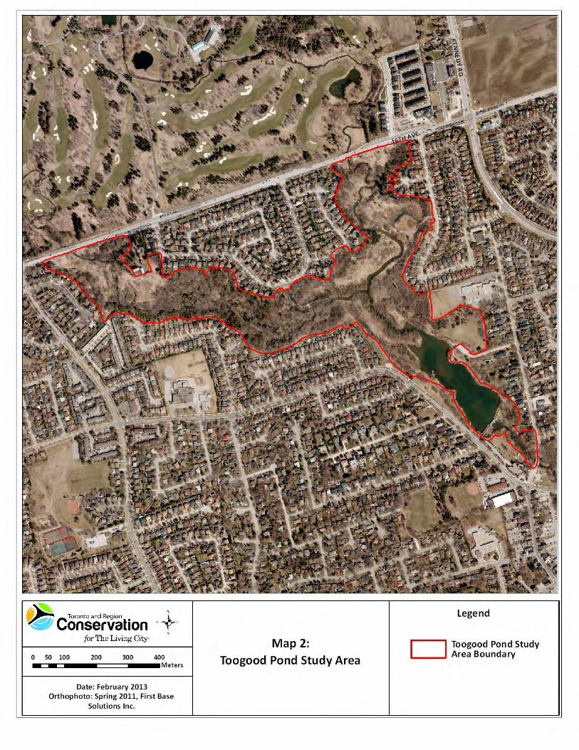
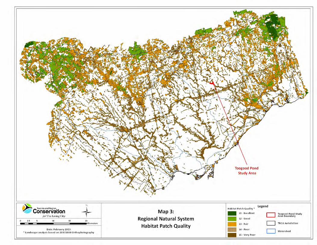
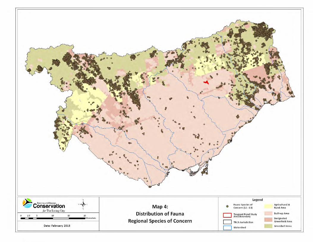


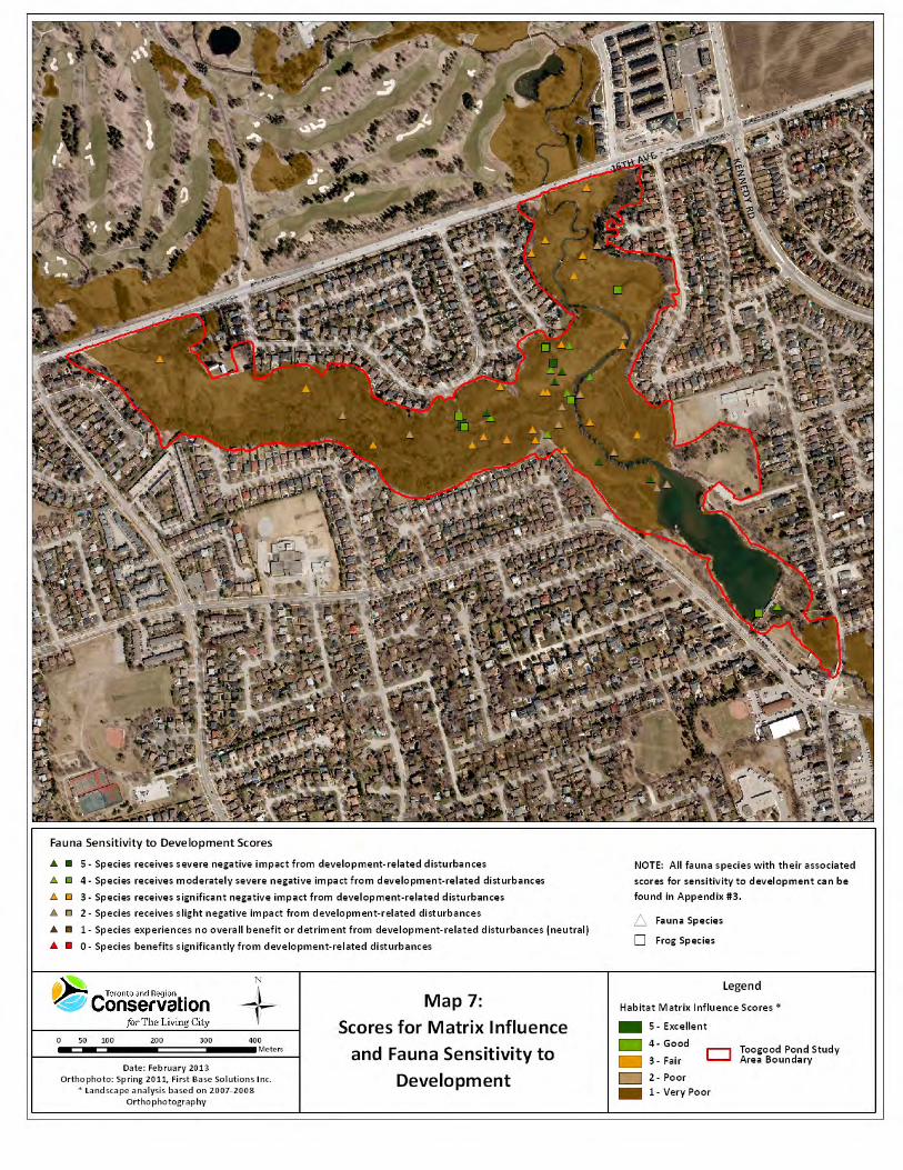
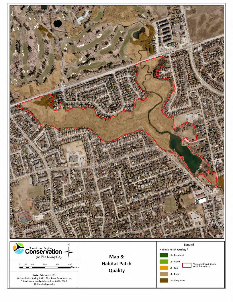

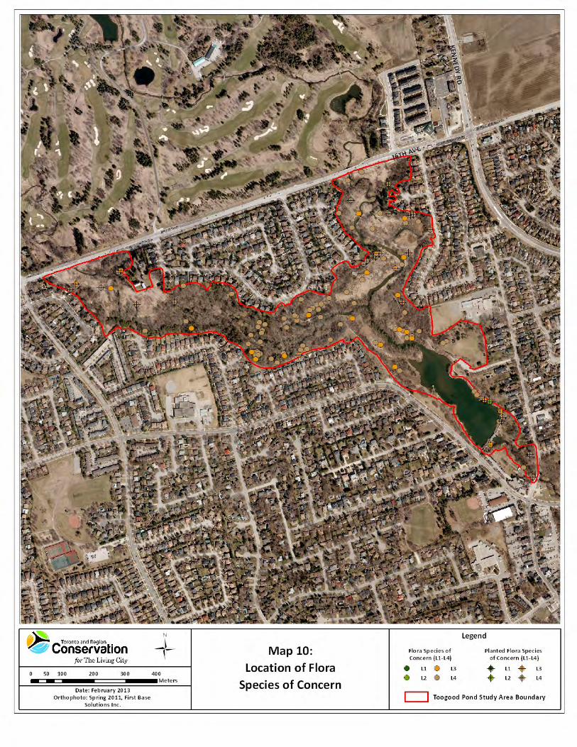


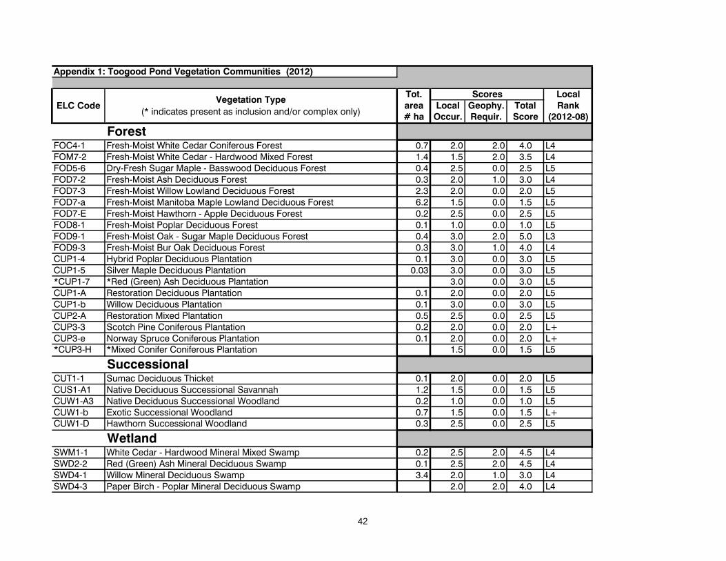
Appendix 1: Toogood Pond Vegetation Communities (2012)
Tot. Localarea Local Geophy. Total Rank# ha Occur. Requir. Score (2012-08)
ForestFOC4-1 Fresh-Moist White Cedar Coniferous Forest 0.7 2.0 2.0 4.0 L4FOM7-2 Fresh-Moist White Cedar - Hardwood Mixed Forest 1.4 1.5 2.0 3.5 L4FOD5-6 Dry-Fresh Sugar Maple - Basswood Deciduous Forest 0.4 2.5 0.0 2.5 L5FOD7-2 Fresh-Moist Ash Deciduous Forest 0.3 2.0 1.0 3.0 L4FOD7-3 Fresh-Moist Willow Lowland Deciduous Forest 2.3 2.0 0.0 2.0 L5FOD7-a Fresh-Moist Manitoba Maple Lowland Deciduous Forest 6.2 1.5 0.0 1.5 L5FOD7-E Fresh-Moist Hawthorn - Apple Deciduous Forest 0.2 2.5 0.0 2.5 L5FOD8-1 Fresh-Moist Poplar Deciduous Forest 0.1 1.0 0.0 1.0 L5FOD9-1 Fresh-Moist Oak - Sugar Maple Deciduous Forest 0.4 3.0 2.0 5.0 L3FOD9-3 Fresh-Moist Bur Oak Deciduous Forest 0.3 3.0 1.0 4.0 L4CUP1-4 Hybrid Poplar Deciduous Plantation 0.1 3.0 0.0 3.0 L5CUP1-5 Silver Maple Deciduous Plantation 0.03 3.0 0.0 3.0 L5*CUP1-7 *Red (Green) Ash Deciduous Plantation 3.0 0.0 3.0 L5CUP1-A Restoration Deciduous Plantation 0.1 2.0 0.0 2.0 L5CUP1-b Willow Deciduous Plantation 0.1 3.0 0.0 3.0 L5CUP2-A Restoration Mixed Plantation 0.5 2.5 0.0 2.5 L5CUP3-3 Scotch Pine Coniferous Plantation 0.2 2.0 0.0 2.0 L+CUP3-e Norway Spruce Coniferous Plantation 0.1 2.0 0.0 2.0 L+*CUP3-H *Mixed Conifer Coniferous Plantation 1.5 0.0 1.5 L5
SuccessionalCUT1-1 Sumac Deciduous Thicket 0.1 2.0 0.0 2.0 L5CUS1-A1 Native Deciduous Successional Savannah 1.2 1.5 0.0 1.5 L5CUW1-A3 Native Deciduous Successional Woodland 0.2 1.0 0.0 1.0 L5CUW1-b Exotic Successional Woodland 0.7 1.5 0.0 1.5 L+CUW1-D Hawthorn Successional Woodland 0.3 2.5 0.0 2.5 L5
WetlandSWM1-1 White Cedar - Hardwood Mineral Mixed Swamp 0.2 2.5 2.0 4.5 L4SWD2-2 Red (Green) Ash Mineral Deciduous Swamp 0.1 2.5 2.0 4.5 L4SWD4-1 Willow Mineral Deciduous Swamp 3.4 2.0 1.0 3.0 L4SWD4-3 Paper Birch - Poplar Mineral Deciduous Swamp 2.0 2.0 4.0 L4
ELC Code
ScoresVegetation Type
(* indicates present as inclusion and/or complex only)
42

Appendix 1: Toogood Pond Vegetation Communities (2012)
Tot. Localarea Local Geophy. Total Rank# ha Occur. Requir. Score (2012-08)
ELC Code
ScoresVegetation Type
(* indicates present as inclusion and/or complex only)
SWT2-a Exotic Mineral Thicket Swamp 0.1 3.5 1.0 4.5 L+MAM2-2 Reed Canary Grass Mineral Meadow Marsh 0.7 1.0 1.0 2.0 L+MAM2-6 Broad-leaved Sedge Mineral Meadow Marsh 0.5 3.0 2.0 5.0 L3MAM2-10 Forb Mineral Meadow Marsh 1.5 2.0 1.0 3.0 L4MAS2-1A Broad-leaved Cattail Mineral Shallow Marsh 0.2 2.0 1.0 3.0 L4MAS2-1b Narrow-Leaved Cattail Mineral Shallow Marsh 1.6 2.0 0.0 2.0 L+MAS2-4 Broad-leaved Sedge Mineral Shallow Marsh 0.1 3.5 2.0 5.5 L3MAS2-a Common Reed Mineral Shallow Marsh 0.1 3.0 0.0 3.0 L+
AquaticSAM1-2 Duckweed Mixed Shallow Aquatic 0.1 3.0 2.0 5.0 L3SAF1-3 Duckweed Floating-leaved Shallow Aquatic 0.1 2.5 1.0 3.5 L4OAO1-T Turbid Open Aquatic (disturbed unvegetated) 5.3 2.0 0.0 2.0 L+
MeadowCUM1-A Native Forb Meadow 2.8 1.5 0.0 1.5 L5
43

Appendix 2: Toogood Pond Flora Species (2012)Local Popn. Hab. Sens. Total Rank
Occur. Trend Dep. Dev. Score TRCANew Scientific Name New Common Name 1-5 1-5 0-5 0-5 2-20 (08/2012)
Carex alopecoidea foxtail wood sedge 2 3 5 4 14 L3Carex atherodes awned sedge 3 3 5 4 15 L3Chelone glabra turtlehead 2 3 4 5 14 L3Circaea alpina smaller enchanter's nightshade 2 4 5 4 15 L3Cyperus bipartitus two-parted umbrella-sedge 3 3 4 4 14 L3Dryopteris clintoniana Clinton's wood fern 2 4 5 4 15 L3Pilea fontana spring clearweed 2 4 4 4 14 L3Prunus nigra Canada plum 2 4 4 4 14 L3Ribes triste swamp red currant 2 4 4 5 15 L3Teucrium canadense ssp. canadense wood-sage 3 3 4 4 14 L3Acer rubrum red maple 2 4 1 5 12 L4Acer saccharum ssp. nigrum black maple 2 3 4 2 11 L4Acer spicatum mountain maple 2 3 4 4 13 L4Betula alleghaniensis yellow birch 1 4 3 5 13 L4Betula papyrifera paper birch 1 4 2 4 11 L4Bidens tripartita three-parted beggar's-ticks 3 2 4 2 11 L4Caltha palustris marsh marigold 2 4 3 4 13 L4Calystegia sepium ssp. americanum pink hedge bindweed 5 2 3 2 12 L4Cardamine diphylla broad-leaved toothwort 2 3 4 4 13 L4Cardamine maxima hybrid toothwort 3 3 3 3 12 L4Carex aurea golden-fruited sedge 2 2 4 4 12 L4Carex deweyana Dewey's sedge 2 4 3 3 12 L4Carex gracillima graceful sedge 2 3 4 2 11 L4Carex lacustris lake-bank sedge 2 3 3 4 12 L4Cicuta bulbifera bulblet-bearing water-hemlock 2 3 4 3 12 L4Corylus cornuta beaked hazel 2 4 3 4 13 L4Crataegus cf. coccinea var. coccinea scarlet hawthorn 3 2 3 3 11 L4Crataegus macracantha long-spined hawthorn 2 2 4 3 11 L4Cuscuta gronovii swamp dodder 2 3 3 3 11 L4Cystopteris bulbifera bulblet fern 1 3 4 4 12 L4Equisetum variegatum ssp. variegatum variegated scouring-rush 2 2 5 4 13 L4Eupatorium perfoliatum boneset 1 3 4 3 11 L4Fraxinus nigra black ash 1 4 4 3 12 L4Lactuca biennis tall blue lettuce 3 4 2 4 13 L4Leersia virginica white grass 3 2 5 3 13 L4Lilium michiganense Michigan lily 1 4 3 5 13 L4Lycopus americanus cut-leaved water-horehound 1 4 3 3 11 L4Lycopus uniflorus northern water-horehound 2 3 3 3 11 L4Pinus strobus white pine 1 4 3 4 12 L4Populus grandidentata large-toothed aspen 1 3 4 3 11 L4Potamogeton foliosus leafy pondweed 1 3 5 4 13 L4
44
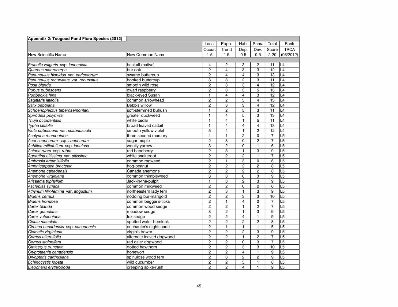
Appendix 2: Toogood Pond Flora Species (2012)Local Popn. Hab. Sens. Total Rank
Occur. Trend Dep. Dev. Score TRCANew Scientific Name New Common Name 1-5 1-5 0-5 0-5 2-20 (08/2012)
Prunella vulgaris ssp. lanceolata heal-all (native) 4 2 3 2 11 L4Quercus macrocarpa bur oak 2 4 3 3 12 L4Ranunculus hispidus var. caricetorum swamp buttercup 2 4 4 3 13 L4Ranunculus recurvatus var. recurvatus hooked buttercup 3 3 2 3 11 L4Rosa blanda smooth wild rose 2 3 3 4 12 L4Rubus pubescens dwarf raspberry 2 3 3 5 13 L4Rudbeckia hirta black-eyed Susan 1 4 4 3 12 L4Sagittaria latifolia common arrowhead 2 2 5 4 13 L4Salix bebbiana Bebb's willow 2 3 3 4 12 L4Schoenoplectus tabernaemontani soft-stemmed bulrush 1 2 5 3 11 L4Spirodela polyrhiza greater duckweed 1 4 5 3 13 L4Thuja occidentalis white cedar 1 4 1 5 11 L4Typha latifolia broad-leaved cattail 1 4 4 4 13 L4Viola pubescens var. scabriuscula smooth yellow violet 5 4 1 2 12 L4Acalypha rhomboidea three-seeded mercury 4 1 2 0 7 L5Acer saccharum ssp. saccharum sugar maple 2 3 0 2 7 L5Achillea millefolium ssp. lanulosa woolly yarrow 3 2 0 1 6 L5Actaea rubra ssp. rubra red baneberry 2 3 1 3 9 L5Ageratina altissima var. altissima white snakeroot 2 2 2 1 7 L5Ambrosia artemisiifolia common ragweed 2 1 3 0 6 L5Amphicarpaea bracteata hog-peanut 2 2 2 2 8 L5Anemone canadensis Canada anemone 2 2 2 2 8 L5Anemone virginiana common thimbleweed 3 3 0 3 9 L5Arisaema triphyllum Jack-in-the-pulpit 1 3 2 3 9 L5Asclepias syriaca common milkweed 2 2 0 2 6 L5Athyrium filix-femina var. angustum northeastern lady fern 2 3 1 3 9 L5Bidens cernua nodding bur-marigold 2 2 3 3 10 L5Bidens frondosa common beggar's-ticks 2 1 4 0 7 L5Carex blanda common wood sedge 2 2 1 2 7 L5Carex granularis meadow sedge 3 2 1 3 9 L5Carex vulpinoidea fox sedge 2 2 4 1 9 L5Cicuta maculata spotted water-hemlock 2 2 2 2 8 L5Circaea canadensis ssp. canadensis enchanter's nightshade 2 1 1 1 5 L5Clematis virginiana virgin's bower 2 2 2 3 9 L5Cornus alternifolia alternate-leaved dogwood 2 2 1 2 7 L5Cornus stolonifera red osier dogwood 2 2 0 3 7 L5Crataegus punctata dotted hawthorn 2 2 3 3 10 L5Cryptotaenia canadensis honewort 2 2 4 1 9 L5Dryopteris carthusiana spinulose wood fern 2 3 2 2 9 L5Echinocystis lobata wild cucumber 2 2 3 1 8 L5Eleocharis erythropoda creeping spike-rush 2 2 4 1 9 L5
45
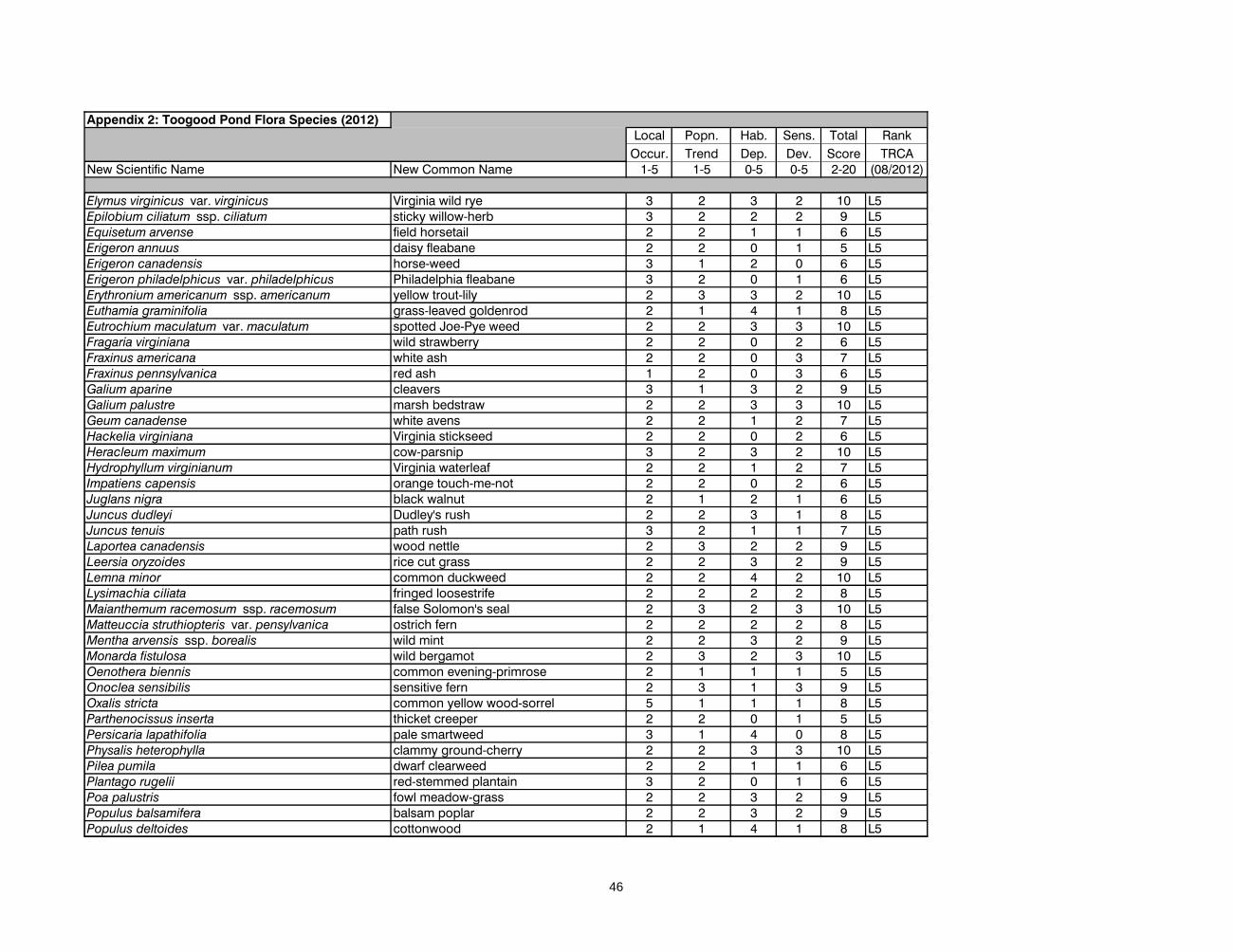
Appendix 2: Toogood Pond Flora Species (2012)Local Popn. Hab. Sens. Total Rank
Occur. Trend Dep. Dev. Score TRCANew Scientific Name New Common Name 1-5 1-5 0-5 0-5 2-20 (08/2012)
Elymus virginicus var. virginicus Virginia wild rye 3 2 3 2 10 L5Epilobium ciliatum ssp. ciliatum sticky willow-herb 3 2 2 2 9 L5Equisetum arvense field horsetail 2 2 1 1 6 L5Erigeron annuus daisy fleabane 2 2 0 1 5 L5Erigeron canadensis horse-weed 3 1 2 0 6 L5Erigeron philadelphicus var. philadelphicus Philadelphia fleabane 3 2 0 1 6 L5Erythronium americanum ssp. americanum yellow trout-lily 2 3 3 2 10 L5Euthamia graminifolia grass-leaved goldenrod 2 1 4 1 8 L5Eutrochium maculatum var. maculatum spotted Joe-Pye weed 2 2 3 3 10 L5Fragaria virginiana wild strawberry 2 2 0 2 6 L5Fraxinus americana white ash 2 2 0 3 7 L5Fraxinus pennsylvanica red ash 1 2 0 3 6 L5Galium aparine cleavers 3 1 3 2 9 L5Galium palustre marsh bedstraw 2 2 3 3 10 L5Geum canadense white avens 2 2 1 2 7 L5Hackelia virginiana Virginia stickseed 2 2 0 2 6 L5Heracleum maximum cow-parsnip 3 2 3 2 10 L5Hydrophyllum virginianum Virginia waterleaf 2 2 1 2 7 L5Impatiens capensis orange touch-me-not 2 2 0 2 6 L5Juglans nigra black walnut 2 1 2 1 6 L5Juncus dudleyi Dudley's rush 2 2 3 1 8 L5Juncus tenuis path rush 3 2 1 1 7 L5Laportea canadensis wood nettle 2 3 2 2 9 L5Leersia oryzoides rice cut grass 2 2 3 2 9 L5Lemna minor common duckweed 2 2 4 2 10 L5Lysimachia ciliata fringed loosestrife 2 2 2 2 8 L5Maianthemum racemosum ssp. racemosum false Solomon's seal 2 3 2 3 10 L5Matteuccia struthiopteris var. pensylvanica ostrich fern 2 2 2 2 8 L5Mentha arvensis ssp. borealis wild mint 2 2 3 2 9 L5Monarda fistulosa wild bergamot 2 3 2 3 10 L5Oenothera biennis common evening-primrose 2 1 1 1 5 L5Onoclea sensibilis sensitive fern 2 3 1 3 9 L5Oxalis stricta common yellow wood-sorrel 5 1 1 1 8 L5Parthenocissus inserta thicket creeper 2 2 0 1 5 L5Persicaria lapathifolia pale smartweed 3 1 4 0 8 L5Physalis heterophylla clammy ground-cherry 2 2 3 3 10 L5Pilea pumila dwarf clearweed 2 2 1 1 6 L5Plantago rugelii red-stemmed plantain 3 2 0 1 6 L5Poa palustris fowl meadow-grass 2 2 3 2 9 L5Populus balsamifera balsam poplar 2 2 3 2 9 L5Populus deltoides cottonwood 2 1 4 1 8 L5
46
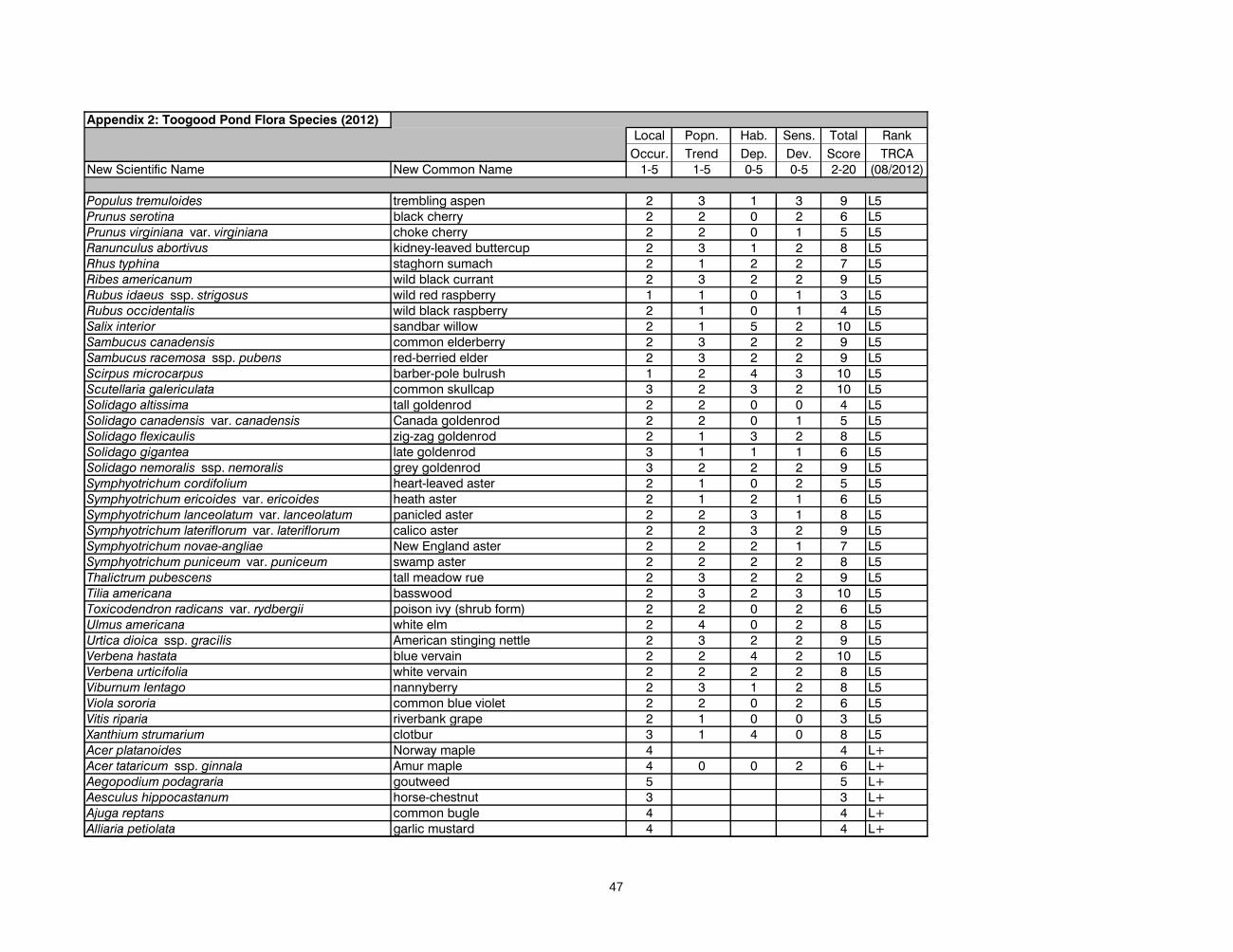
Appendix 2: Toogood Pond Flora Species (2012)Local Popn. Hab. Sens. Total Rank
Occur. Trend Dep. Dev. Score TRCANew Scientific Name New Common Name 1-5 1-5 0-5 0-5 2-20 (08/2012)
Populus tremuloides trembling aspen 2 3 1 3 9 L5Prunus serotina black cherry 2 2 0 2 6 L5Prunus virginiana var. virginiana choke cherry 2 2 0 1 5 L5Ranunculus abortivus kidney-leaved buttercup 2 3 1 2 8 L5Rhus typhina staghorn sumach 2 1 2 2 7 L5Ribes americanum wild black currant 2 3 2 2 9 L5Rubus idaeus ssp. strigosus wild red raspberry 1 1 0 1 3 L5Rubus occidentalis wild black raspberry 2 1 0 1 4 L5Salix interior sandbar willow 2 1 5 2 10 L5Sambucus canadensis common elderberry 2 3 2 2 9 L5Sambucus racemosa ssp. pubens red-berried elder 2 3 2 2 9 L5Scirpus microcarpus barber-pole bulrush 1 2 4 3 10 L5Scutellaria galericulata common skullcap 3 2 3 2 10 L5Solidago altissima tall goldenrod 2 2 0 0 4 L5Solidago canadensis var. canadensis Canada goldenrod 2 2 0 1 5 L5Solidago flexicaulis zig-zag goldenrod 2 1 3 2 8 L5Solidago gigantea late goldenrod 3 1 1 1 6 L5Solidago nemoralis ssp. nemoralis grey goldenrod 3 2 2 2 9 L5Symphyotrichum cordifolium heart-leaved aster 2 1 0 2 5 L5Symphyotrichum ericoides var. ericoides heath aster 2 1 2 1 6 L5Symphyotrichum lanceolatum var. lanceolatum panicled aster 2 2 3 1 8 L5Symphyotrichum lateriflorum var. lateriflorum calico aster 2 2 3 2 9 L5Symphyotrichum novae-angliae New England aster 2 2 2 1 7 L5Symphyotrichum puniceum var. puniceum swamp aster 2 2 2 2 8 L5Thalictrum pubescens tall meadow rue 2 3 2 2 9 L5Tilia americana basswood 2 3 2 3 10 L5Toxicodendron radicans var. rydbergii poison ivy (shrub form) 2 2 0 2 6 L5Ulmus americana white elm 2 4 0 2 8 L5Urtica dioica ssp. gracilis American stinging nettle 2 3 2 2 9 L5Verbena hastata blue vervain 2 2 4 2 10 L5Verbena urticifolia white vervain 2 2 2 2 8 L5Viburnum lentago nannyberry 2 3 1 2 8 L5Viola sororia common blue violet 2 2 0 2 6 L5Vitis riparia riverbank grape 2 1 0 0 3 L5Xanthium strumarium clotbur 3 1 4 0 8 L5Acer platanoides Norway maple 4 4 L+Acer tataricum ssp. ginnala Amur maple 4 0 0 2 6 L+Aegopodium podagraria goutweed 5 5 L+Aesculus hippocastanum horse-chestnut 3 3 L+Ajuga reptans common bugle 4 4 L+Alliaria petiolata garlic mustard 4 4 L+
47
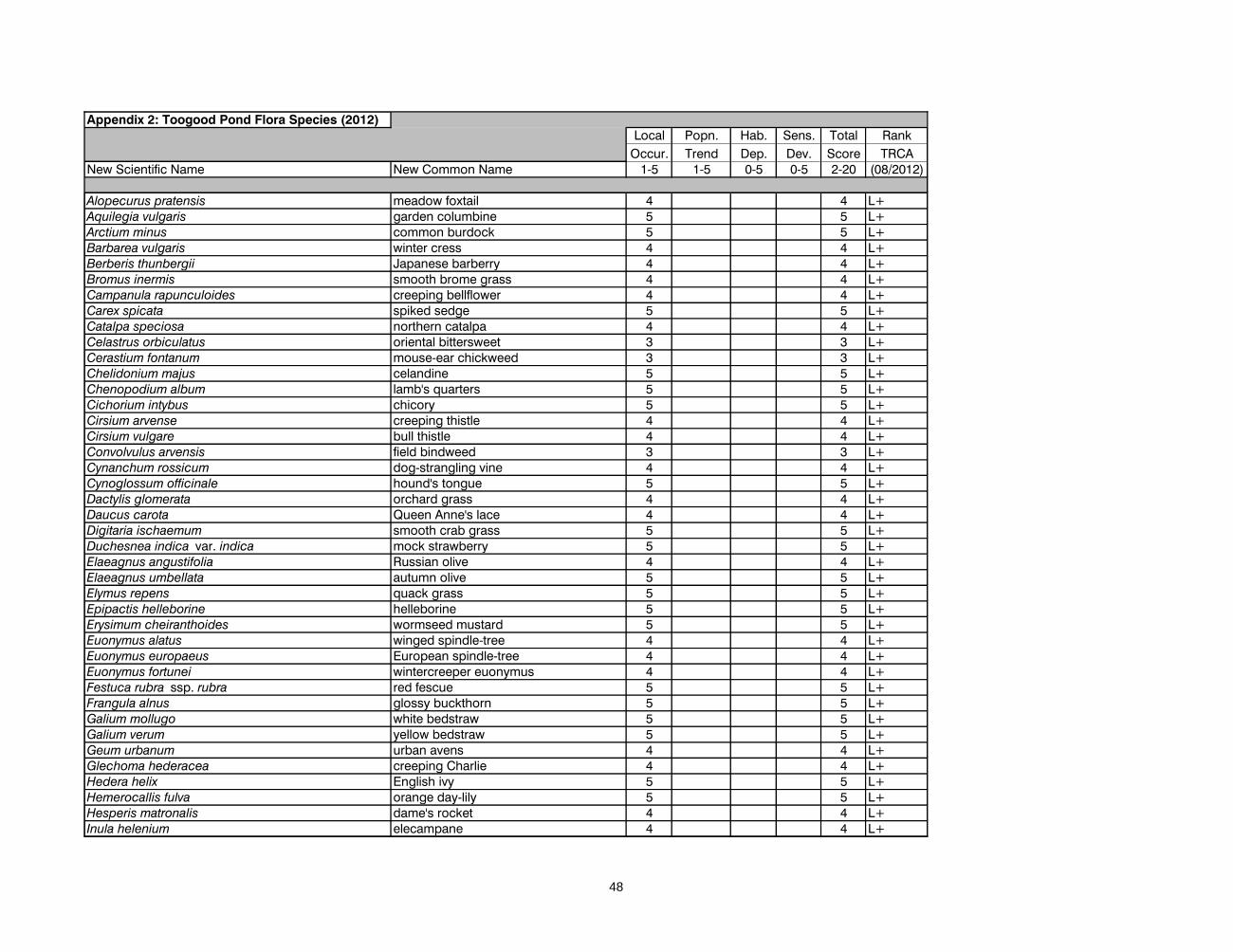
Appendix 2: Toogood Pond Flora Species (2012)Local Popn. Hab. Sens. Total Rank
Occur. Trend Dep. Dev. Score TRCANew Scientific Name New Common Name 1-5 1-5 0-5 0-5 2-20 (08/2012)
Alopecurus pratensis meadow foxtail 4 4 L+Aquilegia vulgaris garden columbine 5 5 L+Arctium minus common burdock 5 5 L+Barbarea vulgaris winter cress 4 4 L+Berberis thunbergii Japanese barberry 4 4 L+Bromus inermis smooth brome grass 4 4 L+Campanula rapunculoides creeping bellflower 4 4 L+Carex spicata spiked sedge 5 5 L+Catalpa speciosa northern catalpa 4 4 L+Celastrus orbiculatus oriental bittersweet 3 3 L+Cerastium fontanum mouse-ear chickweed 3 3 L+Chelidonium majus celandine 5 5 L+Chenopodium album lamb's quarters 5 5 L+Cichorium intybus chicory 5 5 L+Cirsium arvense creeping thistle 4 4 L+Cirsium vulgare bull thistle 4 4 L+Convolvulus arvensis field bindweed 3 3 L+Cynanchum rossicum dog-strangling vine 4 4 L+Cynoglossum officinale hound's tongue 5 5 L+Dactylis glomerata orchard grass 4 4 L+Daucus carota Queen Anne's lace 4 4 L+Digitaria ischaemum smooth crab grass 5 5 L+Duchesnea indica var. indica mock strawberry 5 5 L+Elaeagnus angustifolia Russian olive 4 4 L+Elaeagnus umbellata autumn olive 5 5 L+Elymus repens quack grass 5 5 L+Epipactis helleborine helleborine 5 5 L+Erysimum cheiranthoides wormseed mustard 5 5 L+Euonymus alatus winged spindle-tree 4 4 L+Euonymus europaeus European spindle-tree 4 4 L+Euonymus fortunei wintercreeper euonymus 4 4 L+Festuca rubra ssp. rubra red fescue 5 5 L+Frangula alnus glossy buckthorn 5 5 L+Galium mollugo white bedstraw 5 5 L+Galium verum yellow bedstraw 5 5 L+Geum urbanum urban avens 4 4 L+Glechoma hederacea creeping Charlie 4 4 L+Hedera helix English ivy 5 5 L+Hemerocallis fulva orange day-lily 5 5 L+Hesperis matronalis dame's rocket 4 4 L+Inula helenium elecampane 4 4 L+
48
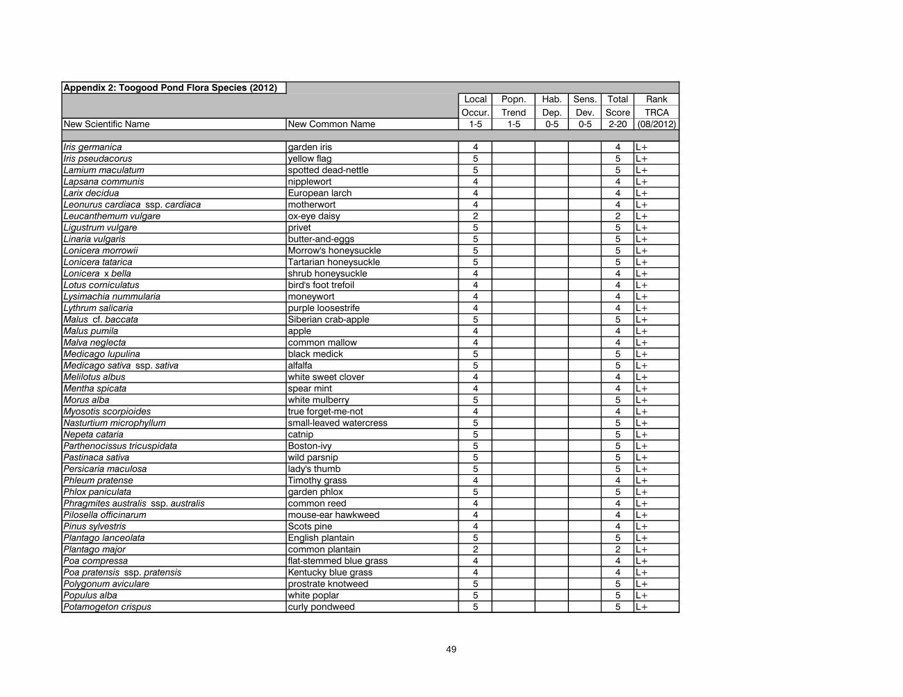
Appendix 2: Toogood Pond Flora Species (2012)Local Popn. Hab. Sens. Total Rank
Occur. Trend Dep. Dev. Score TRCANew Scientific Name New Common Name 1-5 1-5 0-5 0-5 2-20 (08/2012)
Iris germanica garden iris 4 4 L+Iris pseudacorus yellow flag 5 5 L+Lamium maculatum spotted dead-nettle 5 5 L+Lapsana communis nipplewort 4 4 L+Larix decidua European larch 4 4 L+Leonurus cardiaca ssp. cardiaca motherwort 4 4 L+Leucanthemum vulgare ox-eye daisy 2 2 L+Ligustrum vulgare privet 5 5 L+Linaria vulgaris butter-and-eggs 5 5 L+Lonicera morrowii Morrow's honeysuckle 5 5 L+Lonicera tatarica Tartarian honeysuckle 5 5 L+Lonicera x bella shrub honeysuckle 4 4 L+Lotus corniculatus bird's foot trefoil 4 4 L+Lysimachia nummularia moneywort 4 4 L+Lythrum salicaria purple loosestrife 4 4 L+Malus cf. baccata Siberian crab-apple 5 5 L+Malus pumila apple 4 4 L+Malva neglecta common mallow 4 4 L+Medicago lupulina black medick 5 5 L+Medicago sativa ssp. sativa alfalfa 5 5 L+Melilotus albus white sweet clover 4 4 L+Mentha spicata spear mint 4 4 L+Morus alba white mulberry 5 5 L+Myosotis scorpioides true forget-me-not 4 4 L+Nasturtium microphyllum small-leaved watercress 5 5 L+Nepeta cataria catnip 5 5 L+Parthenocissus tricuspidata Boston-ivy 5 5 L+Pastinaca sativa wild parsnip 5 5 L+Persicaria maculosa lady's thumb 5 5 L+Phleum pratense Timothy grass 4 4 L+Phlox paniculata garden phlox 5 5 L+Phragmites australis ssp. australis common reed 4 4 L+Pilosella officinarum mouse-ear hawkweed 4 4 L+Pinus sylvestris Scots pine 4 4 L+Plantago lanceolata English plantain 5 5 L+Plantago major common plantain 2 2 L+Poa compressa flat-stemmed blue grass 4 4 L+Poa pratensis ssp. pratensis Kentucky blue grass 4 4 L+Polygonum aviculare prostrate knotweed 5 5 L+Populus alba white poplar 5 5 L+Potamogeton crispus curly pondweed 5 5 L+
49
Appendix 2: Toogood Pond Flora Species (2012)Local Popn. Hab. Sens. Total Rank
Occur. Trend Dep. Dev. Score TRCANew Scientific Name New Common Name 1-5 1-5 0-5 0-5 2-20 (08/2012)
Potentilla recta sulphur cinquefoil 5 5 L+Prunella vulgaris ssp. vulgaris heal-all (European) 5 5 L+Ranunculus acris tall buttercup 4 4 L+Ranunculus repens creeping buttercup 4 4 L+Rhamnus cathartica common buckthorn 4 4 L+Ribes rubrum garden red currant 4 4 L+Robinia pseudoacacia black locust 3 3 L+Rosa multiflora multiflora rose 4 4 L+Rudbeckia fulgida orange coneflower 5 5 L+Rumex crispus curly dock 5 5 L+Salix alba white willow 5 5 L+Salix x fragilis crack willow 3 3 L+Salix x sepulcralis weeping willow 5 5 L+Schedonorus arundinaceus tall fescue 4 4 L+Schedonorus pratensis meadow fescue 4 4 L+Scilla siberica Siberian squill 4 4 L+Sedum acre mossy stonecrop 4 4 L+Setaria viridis green foxtail 3 3 L+Solanum dulcamara bittersweet nightshade 4 4 L+Sorbus aucuparia European mountain-ash 5 5 L+Syringa vulgaris common lilac 4 4 L+Syringa cf. x prestoniae Preston lilac 5 5 L+Taraxacum officinale dandelion 4 4 L+Taxus cuspidata Japanese yew 4 4 L+Tilia cordata little-leaf linden 5 5 L+Tilia x flavescens hybrid linden 5 5 L+Tragopogon pratensis meadow goat's beard 3 3 L+Trifolium repens white clover 5 5 L+Tussilago farfara coltsfoot 4 4 L+Typha angustifolia narrow-leaved cattail 3 3 L+Typha x glauca hybrid cattail 3 3 L+Ulmus pumila Siberian elm 4 4 L+Verbascum thapsus common mullein 4 4 L+Veronica arvensis corn speedwell 4 4 L+Veronica serpyllifolia ssp. serpyllifolia thyme-leaved speedwell 5 5 L+Viburnum opulus ssp. opulus European highbush cranberry 4 4 L+Vicia cracca cow vetch 4 4 L+Vinca minor periwinkle 5 5 L+Acer negundo Manitoba maple 4 0 0 2 6 L+?Agrostis stolonifera creeping bent grass 5 5 L+?Atriplex prostrata spreading orache 5 5 L+?
50

Appendix 2: Toogood Pond Flora Species (2012)Local Popn. Hab. Sens. Total Rank
Occur. Trend Dep. Dev. Score TRCANew Scientific Name New Common Name 1-5 1-5 0-5 0-5 2-20 (08/2012)
Geranium robertianum herb Robert 4 4 L+?Persicaria hydropiper water-pepper 3 3 L+?Phalaris arundinacea reed canary grass 3 3 L+?Potentilla norvegica rough cinquefoil 3 3 L+?Veronica sp. veronica sp. L+?Aronia melanocarpa black choke-berry 3 5 5 4 17 pL2Bolboschoenus fluviatilis river bulrush 3 2 5 4 14 pL3Pinus resinosa red pine 2 5 5 5 17 pL2Cornus amomum ssp. obliqua silky dogwood 3 3 5 3 14 pL3Picea glauca white spruce 1 5 4 4 14 pL3Abies balsamea balsam fir 1 3 4 5 13 pL4Acer saccharinum silver maple 1 2 5 3 11 pL4Amelanchier arborea downy serviceberry 3 2 4 3 12 pL4Diervilla lonicera bush honeysuckle 2 3 2 4 11 pL4Fagus grandifolia American beech 1 4 3 4 12 pL4Quercus rubra red oak 1 4 2 4 11 pL4Spiraea alba wild spiraea 2 4 4 3 13 pL4Cornus foemina ssp. racemosa grey dogwood 3 2 3 2 10 pL5Juniperus virginiana red cedar 2 2 4 2 10 pL5Caragana arborescens Siberian pea-shrub 5 5 pL+Dipsacus fullonum teasel 5 5 pL+Eleutherococcus sieboldianus five-fingered aralia 5 pL+Forsythia viridissima forsythia 4 4 pL+Fraxinus mandshurica Manchurian ash 5 pL+Picea abies Norway spruce 5 5 pL+Picea pungens Colorado spruce 5 5 pL+Pinus banksiana Jack pine 5 5 pL+Pinus nigra Austrian pine 5 5 pL+Populus x canadensis Carolina poplar 4 4 pL+Rhus aromatica fragrant sumach 5 5 pL+Taxodium distichum bald cypress 5 pL+Physostegia virginiana ssp. virginiana false dragonhead 4 3 4 4 15 prL3Sorbaria sorbifolia false spiraea 4 4 prL+
51
Appendix 3: List of Breeding Fauna Species at Toogood Pond (2003 to 2012).
Common Name Code Scientific Name count LO PTn PTt AS PIS HD StD + TS L-Rank
Survey Species: species for which the TRCA protocol effectively surveys.
Birdssora SORA Porzana carolina 1 (2009) 1 2 2 2 3 3 4 0 17 L3
Virginia Rail VIRA Rallus limicola 1 (2011) 0 2 2 2 3 3 4 0 16 L3
American redstart AMRE Setophaga ruticilla 1 0 2 2 3 1 2 4 0 14 L4
barn swallow BARS Hirundo rustica 1 0 2 3 1 1 2 1 0 10 L4
belted kingfisher BEKI Ceryle alcyon ? 0 3 2 2 1 2 2 0 12 L4
blue-grey gnatcatcher BGGN Polioptila caerulea 3 0 1 1 3 1 1 3 0 10 L4
common yellowthroat COYE Geothlypis trichas 1 (2009) 0 2 2 1 2 1 4 0 12 L4
eastern kingbird EAKI Tyrannus tyrannus 1 0 4 2 2 1 1 3 0 13 L4
eastern wood-pewee EAWP Contopus virens 4 0 4 2 2 1 1 3 0 13 L4
grey catbird GRCA Dumetella carolinensis 3 0 2 2 1 1 1 3 0 10 L4
hairy woodpecker HAWO Picoides villosus 1 0 2 2 3 1 2 2 0 12 L4
indigo bunting INBU Passerina cyanea 1 (2009) 0 2 2 1 1 2 4 0 12 L4
red-breasted nuthatch RBNU Sitta canadensis 2 0 1 2 3 1 1 2 0 10 L4
red-eyed vireo REVI Vireo olivaceus 5 0 2 2 2 1 1 3 0 11 L4
rose-breasted grosbeak RBGR Pheucticus ludovicianus 2 0 2 2 3 1 2 3 0 13 L4
ruby-throated hummingbird RTHU Archilochus colubris 1 0 2 2 1 1 2 2 0 10 L4
spotted sandpiper SPSA Actitis macularia 2 0 2 3 1 2 1 4 0 13 L4
swamp sparrow SWSP Melospiza georgiana 5 0 1 2 1 2 1 5 1 13 L4
tree swallow TRES Tachycineta bicolor 2 0 2 2 1 1 2 2 0 10 L4
white-breasted nuthatch WBNU Sitta carolinensis 2 0 2 2 3 1 2 2 0 12 L4
American Crow AMCR Corvus brachyrhynchos x 0 1 2 1 1 0 0 0 5 L5
American goldfinch AMGO Carduelis tristis x 0 2 2 1 1 0 1 0 7 L5
American robin AMRO Turdus migratorius x 0 1 2 1 1 0 1 0 6 L5
Baltimore oriole BAOR Icterus galbula x 0 2 2 1 1 0 1 0 7 L5
black-capped chickadee BCCH Parus atricapillus x 0 1 2 1 1 0 1 0 6 L5
blue jay BLJA Cyanocitta cristata x 0 4 2 1 1 0 1 0 9 L5
brown-headed cowbird BHCO Molothrus ater x 0 2 2 1 1 0 1 0 7 L5
Canada goose CANG Branta canadensis x 0 1 1 1 2 1 0 0 6 L5
cedar waxwing CEDW Bombycilla cedrorum x 0 1 2 1 1 0 1 0 6 L5
chipping sparrow CHSP Spizella passerina x 0 2 2 1 1 0 2 0 8 L5
common grackle COGR Quiscalus quiscula x 0 3 2 1 1 0 1 0 8 L5
downy woodpecker DOWO Picoides pubescens x 0 3 2 1 1 1 1 0 9 L5
house wren HOWR Troglodytes aedon x 0 2 2 1 2 1 1 0 9 L5
52
Appendix 3: List of Breeding Fauna Species at Toogood Pond (2003 to 2012).
Common Name Code Scientific Name count LO PTn PTt AS PIS HD StD + TS L-Rank
mallard MALL Anas platyrhynchos x 0 2 2 1 2 0 1 0 8 L5
mourning dove MODO Zenaida macroura x 0 2 2 1 1 0 0 0 6 L5
northern cardinal NOCA Cardinalis cardinalis x 0 2 2 1 1 1 2 0 9 L5
red-winged blackbird RWBL Agelaius phoeniceus x 0 2 2 1 1 0 2 0 8 L5
song sparrow SOSP Melospiza melodia x 0 2 2 1 2 0 2 0 9 L5
warbling vireo WAVI Vireo gilvus x 0 1 2 1 1 1 2 0 8 L5
yellow warbler YWAR Setophaga petechia x 0 1 2 1 1 1 3 0 9 L5
European starling EUST Sturnus vulgaris x L+
house finch HOFI Carpodacus mexicanus x L+
house sparrow HOSP Passer domesticus x L+
Herpetofaunabullfrog BUFR Lithobates catesbeiana 1 3 3 2 2 4 2 5 1 22 L2
grey treefrog TGTF Hyla versicolor 1 (2011) 0 3 3 3 4 2 5 1 21 L2
wood frog WOFR Lithobates sylvatica 1 (2010) 0 2 3 3 4 3 5 1 21 L2
northern leopard frog LEFR Lithobates pipiens 1 0 3 2 1 4 2 5 1 18 L3
American toad AMTO Anaxyrus americanus x 0 3 2 1 4 0 4 0 14 L4
green frog GRFR Lithobates clamitans x 0 2 2 1 3 1 4 0 13 L4
Incidental Species: species that are reported on as incidental to the TRCA protocol.
Mammalseastern chipmunk EACH Tamias striatus x 0 2 2 2 3 1 3 0 13 L4
muskrat MUSK Ondatra zibethicus x 0 2 2 1 3 1 3 0 12 L4
red squirrel RESQ Tamiasciurus hudsonicus x 0 2 2 1 3 1 2 0 11 L4
white-tailed deer WTDE Odocoileus virginianus x 0 2 1 3 2 2 1 0 11 L4
coyote COYO Canis latrans x 0 2 2 1 3 0 1 0 9 L5
grey squirrel GRSQ Sciurus carolinensis x 0 2 2 1 3 0 0 0 8 L5
raccoon RACC Procyon lotor x 0 2 2 1 3 1 0 0 9 L5
Herpetofaunacommon snapping turtle SNTU Chelydra serpentina serpentina x 0 3 3 1 5 2 5 2 21 L2
midland painted turtle MPTU Chrysemys picta marginata x 0 2 2 1 5 1 4 1 16 L3
eastern gartersnake EAGA Thamnophis sirtalis sirtalis x 0 2 2 1 3 0 3 0 11 L4
53
Appendix 3: List of Breeding Fauna Species at Toogood Pond (2003 to 2012).
Common Name Code Scientific Name count LO PTn PTt AS PIS HD StD + TS L-Rank
red-eared slider SLID Trachemys scripta elegans x L+
LEGENDLO = local occurrence PIS = Patch Isolation Sensitivity LX = extirpatedPTn = population trend, continent-wideSTD = sensitivity to development L+= non-native/introducedPTt = population trend, TRCA + = additional pointsHD = habitat dependence TS = total scoreAS = area sensitivity L-rank = TRCA Rank, October, 2008
54