Embed Size (px)
Citation preview
Section 3.13 Station Planning, Land Use, and Development
California High-Speed Rail Authority February 2020
Bakersfield to Palmdale Project Section Administrative Draft Project EIR/EIS Page | 3.13-1
3.13 Station Planning, Land Use, and Development This section provides an analysis of station planning, land use, and development impacts associated with the Bakersfield to Palmdale Project Section (B-P) of the California High-Speed Rail (HSR) System.
Summary of Results Construction of the HSR project would result in the temporary alteration of existing land use patterns, the permanent conversion of existing and planned land uses to transportation uses, and potential disruptions to planned developments. However, mitigation measures pertaining to land use, air quality, noise and vibration, aesthetics, socioeconomics and communities, and parks and recreation would help avoid and/or reduce potential temporary land use and development effects. Permanent conversion of land to transportation use, permanent disruption to planned development, and conflict with existing land uses would be considered impacts pursuant to the National Environmental Policy Act (NEPA). The Bakersfield to Palmdale Project Section would reduce land use inconsistencies near the Palmdale Station site and the Bakersfield Station sites. The HSR project would result in significant and unavoidable impacts pursuant to the California Environmental Quality Act (CEQA) related to land use changes under the B-P Build Alternatives. The HSR project is consistent with the goals and policies in the Cities of Bakersfield and Palmdale that support development of an HSR station. Compared with the No Project Alternative, the HSR project would be a stronger catalyst for the improved accessibility and transit-oriented development (TOD) envisioned in these local planning documents.
For project construction, Alternative 5 would temporarily use the most land outside the permanent footprint (1,694 acres), whereas Alternative 2 (without the César E. Chávez National Monument Design option [CCNM Design Option]) would temporarily use the least amount of land outside the permanent footprint (1,637 acres). With the CCNM Design Option, the B-P Build Alternatives would temporarily use an additional 15 acres of land outside of the permanent footprint during construction. With the Refined CCNM Design Option, the B-P Build Alternatives would temporarily use 66 fewer acres of land outside of the permanent footprint during construction.
All B-P Build Alternatives (including the CCNM Design Option and Refined CCNM Design Option) would result in permanent changes to visual character and views for residential and public uses (schools) and could cause parcel severance, which could disrupt farm operations. Alternative 5 would impact the largest number of facilities, displacing 368 residential units, 329 businesses, and 6 community facilities. Alternative 3 would result in fewer displacements than Alternative 5, with 255 residential units, 311 businesses, and 3 community facilities displaced. Alternatives 1 and 2 would result in the fewest displacements (253 residential units, 311 businesses, and 3 community facilities displaced). The CCNM Design Option and the Refined CCNM Design Option would not affect the number of displacements under any of the B-P Build Alternatives.
Of the B-P Build Alternatives, Alternative 3 would permanently convert the most land (6,164 acres) to transportation uses, and Alternative 2 would permanently convert the least amount of land (6,056 acres). With the CCNM Design Option, the B-P Build Alternatives would convert 12 fewer acres of land. With the Refined CCNM Design Option, the B-P Build Alternatives would permanently convert an additional 774 acres of land.
All B-P Build Alternatives would conflict with a proposed residential tract to be built in Lancaster, would require the minor reconfiguration of a proposed truck stop in Tehachapi, and would result in permanent noise level increases adjacent to residential and noise-sensitive commercial uses, parks, and schools.
The Bakersfield Station—Fresno to Bakersfield Locally Generated Alternative (F-B LGA) from the intersection of 34th and L Street to Oswell Street would not cause substantial changes in the long-term pattern or intensity of land use that would be inconsistent with adjacent land uses. The Palmdale Station site could result in land use conflicts; however, those land use conflicts are not anticipated to change land use patterns.
Section 3.13 Station Planning, Land Use, and Development
February 2020 California High-Speed Rail Authority
3.13-2 | Page Bakersfield to Palmdale Project Section Administrative Draft Project EIR/EIS
3.13.1 Introduction This section provides an analysis of station planning, land use, and development impacts associated with the Bakersfield to Palmdale Project Section of the California HSR System, including the proposed Bakersfield and Palmdale Stations and station areas, and the project maintenance facilities. NEPA and CEQA require evaluation of impacts on land use. This analysis focuses on how project construction and operation would affect adjacent land uses, as well as the impacts from construction and operation of the proposed stations on the Cities of Bakersfield and Palmdale.
Station Planning, Land Use, and Development The intent of the land use section is to evaluate existing development patterns and local land use policies in order to determine whether or not the project is consistent with these plans. The proposed B-P Build Alternative stations have been designed in coordination with local governments and with their plans and policies in mind.
This section also addresses whether the project would be consistent with regional and local land use goals and policies. The Bakersfield to Palmdale Project Section includes rural areas in unincorporated Kern and Los Angeles Counties, as well as urban areas in Bakersfield, Tehachapi, Lancaster, and Palmdale. In urban areas, existing land uses are primarily residential (single-family and multifamily), industrial, commercial, public, and recreational. Agriculture is the primary land use in rural areas.
Further, this section summarizes the analyses of station planning, land use, and development impacts associated with the Bakersfield Station areas. The Fresno to Bakersfield Project Section environmental documents provide analysis
for the section between the potential Bakersfield Station sites and Oswell Street in Bakersfield. The Bakersfield Station to Oswell Street area analysis is drawn from the F-B LGA document but is considered as part of the Bakersfield to Palmdale Project Section Environmental Impact Report/Environmental Impact Statement (EIR/EIS). Also, each project-level environmental document evaluates a project that serves a useful transportation purpose on its own and could function independently even if the adjacent sections were not completed.
The development of the HSR project involves collaboration with the Cities of Bakersfield and Palmdale on upcoming updates to local general plans and land use planning processes to establish opportunities for enhanced TOD near the HSR stations. The California High-Speed Rail Authority (Authority) is funding station area planning efforts in Bakersfield and Palmdale.
The following sections provide additional information related to land use and development:
• Section 3.2, Transportation, provides information regarding parking.
• Section 3.12, Socioeconomics and Communities, includes information regarding demographics, property acquisitions and displacements, economic factors, and communities and neighborhoods.
• Section 3.14, Agricultural Lands, provides information regarding impacts on agricultural land.
• Section 3.15, Parks, Recreation, and Open Space, provides information regarding park, recreation, and open space impacts.
• Section 3.16, Aesthetics and Visual Quality, provides information regarding aesthetic and visual impacts on adjacent uses.
• Section 3.18, Regional Growth, provides information regarding regional growth, construction and operation employment, and the project’s potential to induce growth related to population and employment.
What is Transit-Oriented Development?
A transit-oriented development (TOD) is a pattern of dense, diverse, pedestrian-friendly land uses located near transit nodes, which under the right conditions, translates into higher transit patronage (Transit Cooperative Research Program 2004).
Section 3.13 Station Planning, Land Use, and Development
California High-Speed Rail Authority February 2020
Bakersfield to Palmdale Project Section Administrative Draft Project EIR/EIS Page | 3.13-3
The following sections discuss mitigation measures that would minimize project impacts on adjacent land uses:
• Section 3.3, Air Quality and Global Climate Change (Subsection 3.3.7) • Section 3.4, Noise and Vibration (Subsection 3.4.7) • Section 3.12, Socioeconomics and Communities (Subsection 3.12.7) • Section 3.15, Parks, Recreation, and Open Space (Subsection 3.15.7) • Section 3.16, Aesthetics and Visual Quality (Subsection 3.16.7)
3.13.2 Laws, Regulations and Orders 3.13.2.1 Federal Farmland Protection Policy Act (7 U.S.C. §§ 4201–4209 and 7 C.F.R. Part 658) The Farmland Protection Policy Act requires that before taking or approving any federal action that would result in conversion of farmland, the agency must examine the effects of the action using the criteria set forth in the Farmland Protection Policy Act. If there are adverse effects, the agency must consider the following alternatives to lessen them in coordination with the Natural Resource Conservation Service.
Federal Land Policy and Management Act (43 U.S.C. §§ 1701–1782) The Federal Land Policy and Management Act directs how the U.S. Department of the Interior, Bureau of Land Management manages public lands. The bureau sets forth guidelines for public land use planning and management, which include preservation and protection of certain lands in their natural condition where appropriate.
3.13.2.2 State California Land Conservation Act (California Government Code Section 51200 et seq.) The California Land Conservation Act, commonly known as the Williamson Act, provides tax incentives for the voluntary enrollment of agricultural and open space lands in contracts between local government and landowners. Such contracts help to deter the early conversion of agricultural and open-space lands.
Sustainable Communities and Climate Protection Act of 2008 (Senate Bill 375, Chapter 728) This statute requires regional planning agencies to include a “Sustainable Community Strategy” (SCS) or “Alternative Planning Strategy” in the next version of their Regional Transportation Plans (RTP). The SCS will coordinate land use, housing needs, and transportation/transit planning to meet the regional target for the reduction of greenhouse gas emissions from automobiles and light trucks established by the California Air Resources Board.
Coordination is enforced by requiring transportation projects identified in the RTP to comply with the SCS in order to receive state and federal funding through the regional housing needs allocation. The requirements of Senate Bill 375 are reflected in the 2014 RTP adopted by the Kern Council of Governments and the 2016 RTP/SCS adopted by the Southern California Association of Governments.
California State Planning and Zoning Law (California Gov. Code §§ 65000–66037) This law delegates most of the state’s local land use and development decisions to cities and counties. The California Government Code describes laws pertaining to the regulation of land uses by local governments, including general plan requirements, specific plans, subdivisions, and zoning.
3.13.2.3 Regional and Local This section addresses local and regional regulations pertaining to station planning, land use, and development in each of the two counties and the cities or communities in the station planning, land use, and development resource study area (RSA). Because the California HSR Project is a state project, there is no commitment on the part of the state to be 100 percent in compliance with
Section 3.13 Station Planning, Land Use, and Development
February 2020 California High-Speed Rail Authority
3.13-4 | Page Bakersfield to Palmdale Project Section Administrative Draft Project EIR/EIS
local regulations. Rather, local and regional plans are reviewed to ensure consistency. Appendix 2-H in Volume II of the EIR/EIS includes a list of adopted regional and local plans and policies pertaining to station planning, land use, and development.
3.13.3 Regional and Local Policy Analysis Because the HSR project is an undertaking of the Authority, in its capacity as state and federal lead agency, the Authority is neither subject to the jurisdiction of local governments nor required to be consistent with local plans. Council on Environmental Quality and FRA regulations nonetheless call for the discussion of any inconsistency or conflict of a proposed action with regional or local plans and laws. Where inconsistencies or conflicts exist, the Council on Environmental Quality and FRA require a description of the extent of reconciliation and the reason for proceeding if full reconciliation is not feasible (Code of Federal Regulations Title 40, Part 1506.2(d), and Federal Register Volume 64, Page 28545, 14(n)(15)). The CEQA Guidelines also require that an EIR discuss the inconsistencies between the proposed project and applicable general plans, specific plans, and regional plans (CEQA Guidelines, Section 15125(d)). It should be noted that any inconsistency with such plans is not considered an environmental impact under CEQA. An analysis of regional and local policies is included to provide the local planning context. Appendix 2-H, Detailed Plan Consistency Analysis, in Volume II of the EIR/EIS, contains local and regional policies, goals, and objectives related to station planning, land use, and development and describes the consistency of the project section with each local and regional policy.
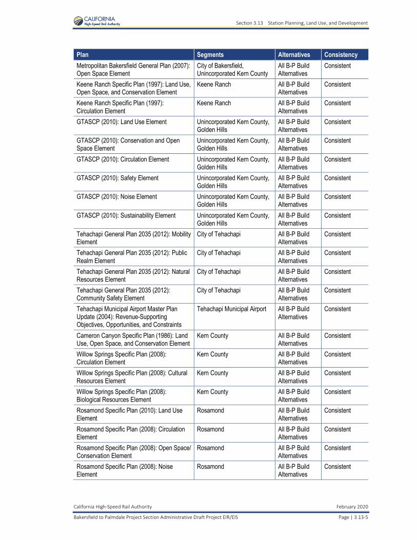
Alternatives 1, 2, 3, and 5 were evaluated for consistency with applicable regional and local policies. Table 3.13-1 provides a summary of the HSR project’s consistency with applicable local and regional policies, goals, and objectives pertaining to station planning, land use, and development. As shown in Table 3.13-1, all B-P Build Alternatives result in the same inconsistency related to the loss of housing stock. Residents displaced by the B-P Build Alternatives would be relocated to suitable replacement housing in the surrounding area. New housing would not be constructed unless sufficient replacement housing is unavailable; therefore, the B-P Build Alternatives are anticipated to result in a net loss of housing in the City of Lancaster, which would be inconsistent with a goal in the Housing Element of the Lancaster General Plan to preserve existing housing stock (City of Lancaster 2009).
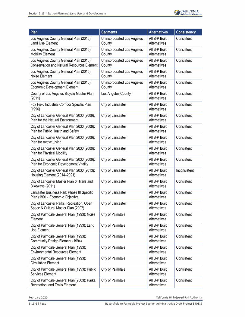
Table 3.13-1 Local and Regional Plan Policy Consistency Analysis Summary
Plan Segments Alternatives Consistency Kern County General Plan (2007): Land Use, Open Space, and Conservation Element
Unincorporated Kern County All B-P Build Alternatives
Consistent
Kern County General Plan (2007): Circulation Element
Unincorporated Kern County All B-P Build Alternatives
Consistent
Kern County Economic Development Strategy Update (2010)
Unincorporated Kern County All B-P Build Alternatives
Consistent
Kern County Bicycle Master Plan and Complete Streets Recommendations (2012)
Kern County All B-P Build Alternatives
Consistent
Metropolitan Bakersfield General Plan (2007): Land Use Element
City of Bakersfield, Unincorporated Kern County
All B-P Build Alternatives
Consistent
Metropolitan Bakersfield General Plan (2007): Circulation Element
City of Bakersfield, Unincorporated Kern County
All B-P Build Alternatives
Consistent
Metropolitan Bakersfield General Plan (2008): Housing Element
City of Bakersfield, Unincorporated Kern County
All B-P Build Alternatives
Consistent
Metropolitan Bakersfield General Plan (2007):Conservation Element
City of Bakersfield, Unincorporated Kern County
All B-P Build Alternatives
Consistent
Section 3.13 Station Planning, Land Use, and Development
California High-Speed Rail Authority February 2020
Bakersfield to Palmdale Project Section Administrative Draft Project EIR/EIS Page | 3.13-5
Plan Segments Alternatives Consistency Metropolitan Bakersfield General Plan (2007): Open Space Element
City of Bakersfield, Unincorporated Kern County
All B-P Build Alternatives
Consistent
Keene Ranch Specific Plan (1997): Land Use, Open Space, and Conservation Element
Keene Ranch All B-P Build Alternatives
Consistent
Keene Ranch Specific Plan (1997): Circulation Element
Keene Ranch All B-P Build Alternatives
Consistent
GTASCP (2010): Land Use Element Unincorporated Kern County, Golden Hills
All B-P Build Alternatives
Consistent
GTASCP (2010): Conservation and Open Space Element
Unincorporated Kern County,Golden Hills
All B-P Build Alternatives
Consistent
GTASCP (2010): Circulation Element Unincorporated Kern County, Golden Hills
All B-P Build Alternatives
Consistent
GTASCP (2010): Safety Element Unincorporated Kern County, Golden Hills
All B-P Build Alternatives
Consistent
GTASCP (2010): Noise Element Unincorporated Kern County, Golden Hills
All B-P Build Alternatives
Consistent
GTASCP (2010): Sustainability Element Unincorporated Kern County, Golden Hills
All B-P Build Alternatives
Consistent
Tehachapi General Plan 2035 (2012): MobilityElement
City of Tehachapi All B-P Build Alternatives
Consistent
Tehachapi General Plan 2035 (2012): Public Realm Element
City of Tehachapi All B-P Build Alternatives
Consistent
Tehachapi General Plan 2035 (2012): Natural Resources Element
City of Tehachapi All B-P Build Alternatives
Consistent
Tehachapi General Plan 2035 (2012): Community Safety Element
City of Tehachapi All B-P Build Alternatives
Consistent
Tehachapi Municipal Airport Master Plan Update (2004): Revenue-Supporting Objectives, Opportunities, and Constraints
Tehachapi Municipal Airport All B-P Build Alternatives
Consistent
Cameron Canyon Specific Plan (1986): Land Use, Open Space, and Conservation Element
Kern County All B-P Build Alternatives
Consistent
Willow Springs Specific Plan (2008): Circulation Element
Kern County All B-P Build Alternatives
Consistent
Willow Springs Specific Plan (2008): Cultural Resources Element
Kern County All B-P Build Alternatives
Consistent
Willow Springs Specific Plan (2008): Biological Resources Element
Kern County All B-P Build Alternatives
Consistent
Rosamond Specific Plan (2010): Land Use Element
Rosamond All B-P Build Alternatives
Consistent
Rosamond Specific Plan (2008): Circulation Element
Rosamond All B-P Build Alternatives
Consistent
Rosamond Specific Plan (2008): Open Space/Conservation Element
Rosamond All B-P Build Alternatives
Consistent
Rosamond Specific Plan (2008): Noise Element
Rosamond All B-P Build Alternatives
Consistent
Section 3.13 Station Planning, Land Use, and Development
February 2020 California High-Speed Rail Authority
3.13-6 | Page Bakersfield to Palmdale Project Section Administrative Draft Project EIR/EIS
Plan Segments Alternatives Consistency Los Angeles County General Plan (2015): Land Use Element
Unincorporated Los Angeles County
All B-P Build Alternatives
Consistent
Los Angeles County General Plan (2015): Mobility Element
Unincorporated Los Angeles County
All B-P Build Alternatives
Consistent
Los Angeles County General Plan (2015): Conservation and Natural Resources Element
Unincorporated Los Angeles County
All B-P Build Alternatives
Consistent
Los Angeles County General Plan (2015): Noise Element
Unincorporated Los Angeles County
All B-P Build Alternatives
Consistent
Los Angeles County General Plan (2015): Economic Development Element
Unincorporated Los Angeles County
All B-P Build Alternatives
Consistent
County of Los Angeles Bicycle Master Plan (2011)
Los Angeles County All B-P Build Alternatives
Consistent
Fox Field Industrial Corridor Specific Plan (1996)
City of Lancaster All B-P Build Alternatives
Consistent
City of Lancaster General Plan 2030 (2009): Plan for the Natural Environment
City of Lancaster All B-P Build Alternatives
Consistent
City of Lancaster General Plan 2030 (2009): Plan for Public Health and Safety
City of Lancaster All B-P Build Alternatives
Consistent
City of Lancaster General Plan 2030 (2009): Plan for Active Living
City of Lancaster All B-P Build Alternatives
Consistent
City of Lancaster General Plan 2030 (2009): Plan for Physical Mobility
City of Lancaster All B-P Build Alternatives
Consistent
City of Lancaster General Plan 2030 (2009): Plan for Economic Development Vitality
City of Lancaster All B-P Build Alternatives
Consistent
City of Lancaster General Plan 2030 (2013): Housing Element (2014–2021)
City of Lancaster All B-P Build Alternatives
Inconsistent
City of Lancaster Master Plan of Trails and Bikeways (2011)
City of Lancaster All B-P Build Alternatives
Consistent
Lancaster Business Park Phase III Specific Plan (1991): Economic Objective
City of Lancaster All B-P Build Alternatives
Consistent
City of Lancaster Parks, Recreation, Open Space & Cultural Master Plan (2007)
City of Lancaster All B-P Build Alternatives
Consistent
City of Palmdale General Plan (1993): Noise Element
City of Palmdale All B-P Build Alternatives
Consistent
City of Palmdale General Plan (1993): Land Use Element
City of Palmdale All B-P Build Alternatives
Consistent
City of Palmdale General Plan (1993): Community Design Element (1994)
City of Palmdale All B-P Build Alternatives
Consistent
City of Palmdale General Plan (1993): Environmental Resources Element
City of Palmdale All B-P Build Alternatives
Consistent
City of Palmdale General Plan (1993): Circulation Element
City of Palmdale All B-P Build Alternatives
Consistent
City of Palmdale General Plan (1993): Public Services Element
City of Palmdale All B-P Build Alternatives
Consistent
City of Palmdale General Plan (2003): Parks,Recreation, and Trails Element
City of Palmdale All B-P Build Alternatives
Consistent
Section 3.13 Station Planning, Land Use, and Development
California High-Speed Rail Authority February 2020
Bakersfield to Palmdale Project Section Administrative Draft Project EIR/EIS Page | 3.13-7
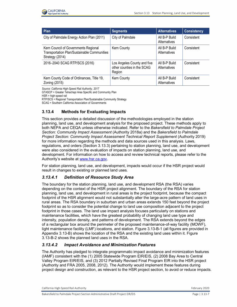
Plan Segments Alternatives Consistency City of Palmdale Energy Action Plan (2011) City of Palmdale All B-P Build
Alternatives Consistent
Kern Council of Governments Regional Transportation Plan/Sustainable Communities Strategy (2014)
Kern County All B-P Build Alternatives
Consistent
2016–2040 SCAG RTP/SCS (2016) Los Angeles County and five other counties in the SCAG Region
All B-P Build Alternatives
Consistent
Kern County Code of Ordinances, Title 19, Zoning (2015)
Kern County All B-P Build Alternatives
Consistent
Source: California High-Speed Rail Authority, 2017 GTASCP = Greater Tehachapi Area Specific and Community Plan HSR = high-speed rail RTP/SCS = Regional Transportation Plan/Sustainable Community Strategy SCAG = Southern California Association of Governments
3.13.4 Methods for Evaluating Impacts This section provides a detailed discussion of the methodologies employed in the station planning, land use, and development analysis for the proposed project. These methods apply to both NEPA and CEQA unless otherwise indicated. Refer to the Bakersfield to Palmdale Project Section: Community Impact Assessment (Authority 2018a) and the Bakersfield to Palmdale Project Section: Community Impact Assessment Technical Report Supplement (Authority 2019) for more information regarding the methods and data sources used in this analysis. Laws, regulations, and orders (Section 3.13.3) pertaining to station planning, land use, and development were also considered in the evaluation of impacts on station planning, land use, and development. For information on how to access and review technical reports, please refer to the Authority’s website at www.hsr.ca.gov.
For station planning, land use, and development, impacts would occur if the HSR project would result in changes to existing or planned land uses.
3.13.4.1 Definition of Resource Study Area The boundary for the station planning, land use, and development RSA (the RSA) varies depending on the context of the HSR project alignment. The boundary of the RSA for station planning, land use, and development in rural areas is the project footprint, because the compact footprint of the HSR alignment would not substantially alter the large-acre pattern of land uses in rural areas. The RSA boundary in suburban and urban areas extends 150 feet beyond the project footprint so as to consider the potential change to land use composition adjacent to the project footprint in those cases. The land use impact analysis focuses particularly on stations and maintenance facilities, which have the greatest probability of changing land use type and intensity, population density, and patterns of development. The RSA extends beyond the edges of a rectangular box around the perimeter of the proposed maintenance-of-way facility (MOWF), light maintenance facility (LMF) locations, and station. Figure 3.13-B-1 (all figures are provided in Appendix 3.13-B) shows the location of the RSA and the existing land uses within it. Figure 3.13-B-2 shows the planned land uses in the RSA.
3.13.4.2 Impact Avoidance and Minimization Features The Authority has pledged to integrate programmatic impact avoidance and minimization features (IAMF) consistent with the (1) 2005 Statewide Program EIR/EIS, (2) 2008 Bay Area to Central Valley Program EIR/EIS, and (3) 2012 Partially Revised Final Program EIR into the HSR project (Authority and FRA 2005, 2008, 2012). The Authority would implement these features during project design and construction, as relevant to the HSR project section, to avoid or reduce impacts.
Section 3.13 Station Planning, Land Use, and Development
February 2020 California High-Speed Rail Authority
3.13-8 | Page Bakersfield to Palmdale Project Section Administrative Draft Project EIR/EIS
These IAMFs are part of all B-P Build Alternatives. IAMFs applicable to station planning, land use, and development are listed below and discussed further in Appendix 2-E of this document.
LU-IAMF#1: HSR Station Area Development General Principals and Guidelines
Prior to Operation and Maintenance, the Authority shall prepare a memorandum for each station describing how the Authority’s station area development principles and guidelines are applied to achieve the anticipated benefits of station area development. Refer to HSR Station Area Development General Principles and Guidelines, February 3, 2011.
LU-IAMF#2: Station Area and Local Agency Coordination
Prior to Operation and Maintenance, the Authority shall prepare a memorandum for each station describing the local agency coordination and station area planning conducted to prepare the station area for HSR operations. Refer to HSR Station Area Development: General Principles and Guidelines, February 3, 2011.
LU-IAMF#3: Restoration of Land Used Temporarily During Construction
Prior to any ground disturbing activities at the site of land to be used temporarily during construction, the Contractor shall prepare a restoration plan addressing specific actions, sequence of implementation, parties responsible for implementation and successful achievement of restoration for temporary impacts. Before beginning construction use of land, the Contractor shall submit the restoration plan to the Authority for review and obtain Authority approval. The restoration plan shall include time-stamped photo documentation of the pre-construction conditions of all temporary staging areas. All construction access, mobilization, material laydown, and staging areas would be returned to a condition equal to the pre-construction staging condition. This requirement is included in the design-build construction contract requirements.
NV-IAMF#1: Noise and Vibration
Prior to Construction, the Contractor shall prepare and submit to the Authority a noise and vibration technical memorandum documenting how the FTA and FRA guidelines for minimizing construction noise and vibration impacts would be employed when work is being conducted within 1,000 feet of sensitive receptors. Typical construction practices contained in the FTA and FRA guidelines for minimizing construction noise and vibration impacts include the following:
• Construct noise barriers, such as temporary walls or piles on excavated material, between noisy activities and noise sensitive resources.
• Route truck traffic away from residential streets, when possible.
• Construct walled enclosures around especially noisy activities or around clusters or noise equipment.
• Combine noisy operations so that they occur in the same period.
• Phase demolition, earthmoving, and ground impacting operations so as not to occur in the same time period.
• Avoid impact pile driving where possible in vibration sensitive areas.
AQ-IAMF#1: Fugitive Dust Emissions
During construction, the Contractor shall employ the following measures to minimize and control fugitive dust emissions. The Contractor shall prepare a fugitive dust control plan for each distinct construction segment. At a minimum, the plan shall describe how each measure would be employed and identify an individual responsible for ensuring implementation. At a minimum, the plan shall address the following components unless alternative measures are approved by the applicable air quality management district.
• Cover all vehicle loads transported on public roads to limit visible dust emissions, and maintain at least 6 inches of freeboard space from the top of the container or truck bed.
Section 3.13 Station Planning, Land Use, and Development
California High-Speed Rail Authority February 2020
Bakersfield to Palmdale Project Section Administrative Draft Project EIR/EIS Page | 3.13-9
• Clean all trucks and equipment before exiting the construction site using an appropriate cleaning station that does not allow runoff to leave the site or mud to be carried on tires off the site.
• Water exposed surfaces and unpaved roads at a minimum three times daily with adequate volume to result in wetting of the top 1 inch of soil but avoiding overland flow. Rain events may result in adequate wetting of top 1 inch of soil thereby alleviating the need to manually apply water.
• Limit vehicle travel speed on unpaved roads to 15 miles per hour (mph).
• Suspend any dust-generating activities when average wind speed exceeds 25 mph.
• Stabilize all disturbed areas, including storage piles that are not being used on a daily basis for construction purposes, by using water, a chemical stabilizer/suppressant, hydro mulch or by covering with a tarp or other suitable cover or vegetative ground cover, to control fugitive dust emissions effectively. In areas adjacent to organic farms, the Authority would use non-chemical means of dust suppression.
• Stabilize all on-site unpaved roads and off-site unpaved access roads, using water or a chemical stabilizer/suppressant, to effectively control fugitive dust emissions. In areas adjacent to organic farms, the Authority would use non-chemical means of dust suppression.
• Carry out watering or presoaking for all land clearing, grubbing, scraping, excavation, land leveling, grading, cut and fill, and demolition activities.
• For buildings up to 6 stories in height, wet all exterior surfaces of buildings during demolition.
• Limit or expeditiously remove the accumulation of mud or dirt from adjacent public streets at a minimum of once daily, using a vacuum type sweeper.
• After the addition of materials to or the removal of materials from surface or outdoor storage piles, apply sufficient water or a chemical stabilizer/suppressant.
AQ-IAMF#2: Selection of Coatings
During construction, the Contractor shall use:
• Low-volatile organic compound (VOC) paint that contains less than 10 percent of VOC contents (VOC, 10%).
• Super-compliant or Clean Air paint that has a lower VOC content than that required by San Joaquin Valley Unified Air Pollution Control District Rule 4601, Eastern Kern Air Pollution Control District 410, and Antelope Valley Air Quality Management District Rule 1113, when available. If not available, the Contractor shall document the lack of availability, recommend alternative measure(s) to comply with Rule 4601, 410, and 1113 or disclose absence of measure(s) for full compliance and obtain concurrence from the Authority.
SOCIO-IAMF#2: Compliance with Uniform Relocation Assistance and Real Property Acquisition Policies Act
The Authority must comply with the Uniform Relocation Assistance and Real Property Acquisition Policies Act, as amended (Uniform Act). The provisions of the Uniform Act, a federally mandated program, would apply to all acquisitions of real property or displacements of persons resulting from this federally assisted project. It was created to provide for fair and equitable treatment of all affected persons. Additionally, the Fifth Amendment of the U.S. Constitution provides that private property may not be taken for a public use without payment of “just compensation.”
The Uniform Act requires that the owning agency provide notification to all affected property owners of the agency’s intent to acquire an interest in their property. This notification includes a written offer letter of just compensation. A right-of-way specialist is assigned to each property owner to assist him or her through the acquisition process. The Uniform Act also provides benefits to displaced individuals to assist them financially and with advisory services related to
Section 3.13 Station Planning, Land Use, and Development
February 2020 California High-Speed Rail Authority
3.13-10 | Page Bakersfield to Palmdale Project Section Administrative Draft Project EIR/EIS
relocating their residence or business operation. Benefits are available to both owner occupants and tenants of either residential or business properties.
The Uniform Act requires provision of relocation benefits to all eligible persons regardless of race, color, religion, sex, or national origin. Benefits to which eligible owners or tenants may be entitled are determined on an individual basis and explained in detail by an assigned right-of-way specialist.
The California Relocation Assistance Act essentially mirrors the Uniform Act and also provides for consistent and fair treatment of property owners. However, because the project would receive federal funding, the Uniform Act takes precedence. Owners of private property have federal and state constitutional guarantees that their property would not be acquired or damaged for public use unless owners first receive just compensation. Just compensation is measured by the “fair market value,” where the property value is considered to be the highest price that would be negotiated on the date of valuation. The value must be agreed upon by a seller who is willing, not obliged to sell, but under no particular or urgent necessity and by a buyer who is ready, willing, and able to buy but under no particular necessity. Both the owner and the buyer must deal with the other with the full knowledge of all the uses and purposes for which the property is reasonably adaptable and available (Code of Civil Procedure Section 1263.320a).
More detailed information about how the Authority plans to comply with the Uniform Act and the California Relocation Assistance Act is provided in the following three detailed relocation assistance documents modeled after Caltrans versions:
• Your Rights and Benefits as a Displacee under the Uniform Relocation Assistance Program (Residential)
• Your Rights and Benefits as a Displacee under the Uniform Relocation Assistance Program (Mobile Home)
• Your Rights and Benefits as a Displaced Business, Farm, or Nonprofit Organization under the Uniform Relocation Assistance Program
SOCIO-IAMF#3: Relocation Mitigation Plan
Before any acquisitions occur, the Authority would develop a relocation mitigation plan, in consultation with affected cities and counties and property owners. In addition to establishing a program to minimize the economic disruption related to relocation, the relocation mitigation plan would be written in a style that also enables it to be used as a public-information document.
The relocation mitigation plan would be designed to meet the following objectives:
• Provide affected property and business owners and tenants a high level of individualized assistance in situations when acquisition is necessary and the property owner desires to relocate the existing land use.
• Coordinate relocation activities with other agencies acquiring property resulting in displacements in the study area to provide for all displaced persons and businesses to receive fair and consistent relocation benefits.
• Make a best effort to minimize the permanent closure of businesses and non-profit agencies as a result of property acquisition.
• Within the limits established by law and regulation, minimize the economic disruption caused to property owners by relocation.
• In individual situations, where warranted, consider the cost of obtaining the entitlement permits necessary to relocate to a suitable location and take those costs into account when establishing the fair market value of the property.
• Provide those business owners who require complex permitting with regulatory compliance assistance.
Section 3.13 Station Planning, Land Use, and Development
California High-Speed Rail Authority February 2020
Bakersfield to Palmdale Project Section Administrative Draft Project EIR/EIS Page | 3.13-11
The relocation mitigation plan would include the following components:
• A description of the appraisal, acquisition, and relocation process as well as a description of the activities of the appraisal and relocation specialists.
• A means of assigning appraisal and relocation staff to affected property owners, tenants, or other residents on an individual basis.
• Individualized assistance to affected property owners, tenants, or other residents in applying for funding, including research to summarize loans, grants, and federal aid available, and research areas for relocation.
• Creation of an ombudsman’s position to act as a single point of contact for property owners, residents, and tenants with questions about the relocation process. The ombudsman would also act to address concerns about the relocation process as it applies to the individual situations of property owners, tenants, and other residents.
AG-IAMF#3: Farmland Consolidation Program
The Authority would establish and administer a farmland consolidation program to sell remnant parcels to neighboring landowners for consolidation with adjacent farmland properties. In addition, the program would assist the owners of remnant parcels in selling those remnants to adjacent landowners, upon request. The goal of the program is to provide for continued agricultural use on the maximum feasible amount of remnant parcels that otherwise may not be economic to farm. The program would focus on severed remainder parcels, including those that were under Williamson Act or Farmland Security Act contract at the time of right-of-way acquisition and have become too small to remain in the local Williamson Act or Farmland Security Act program. The program would assist landowners in obtaining lot line adjustments where appropriate to incorporate remnant parcels into a larger parcel that is consistent with size requirements under the local government regulations.
The program will operate for a minimum of 5 years after construction of the section is completed. The Authority shall document implementation of this measure through issuance of a compliance memorandum- after the minimum operation period of 5 years has elapsed. The document shall be filed with Environmental Mitigation Management and Assessment system (EMMA).
AG-IAMF#4: Notification to Agricultural Property Owners Prior to the start of any construction activity adjacent to farmland, the Authority shall provide written notification to agricultural property owners or leaseholders immediately adjacent to the disturbance limits for the HSR project section. The notification is to indicate the intent to begin construction, including an estimated date for the start of construction. In order to provide agricultural property owners or leaseholders sufficient lead time to make any changes to their operations due to project section construction, this notification shall be provided at least 3 months, but no more than 12 months, prior to the start of construction activity.
AG-IAMF#5: Temporary Livestock and Equipment Crossings
Prior to the start of any construction activity adjacent to any farmland, the Authority shall coordinate with agricultural property owners or leaseholders to provide temporary livestock and equipment crossings to minimize impacts to livestock movement, as well as routine operations and normal business activities, during project construction.
3.13.4.3 Method for Determining Impacts under NEPA NEPA does not provide a definitive threshold to determine significant or potentially significant land use impacts, as described in more detail in the General Methodology Guidance. As such, the author used professional judgment when considering the context, intensity, and duration of impacts. In addition, relevant aspects of context (e.g., existing resource conditions, resource sensitivity), appropriate factors of intensity (e.g., extent of change, duration of change), and implementation of mitigation measures were considered when determining impacts.
Section 3.13 Station Planning, Land Use, and Development
February 2020 California High-Speed Rail Authority
3.13-12 | Page Bakersfield to Palmdale Project Section Administrative Draft Project EIR/EIS
3.13.4.4 Method for Determining Significance under CEQA CEQA requires that an EIR identify the significant environmental impacts of a project (CEQA Guidelines § 15126). One of the primary differences between NEPA and CEQA is that CEQA requires a significance determination for each impact using a threshold-based analysis (see Section 3.1.3.4, Methods for Evaluating Impacts, for further information). By contrast, under NEPA, significance is used to determine whether an EIS would be required; NEPA requires that an EIS be prepared when the proposed federal action (project) as a whole has the potential to “significantly affect the quality of the human environment.” Accordingly, Section 3.13.9, CEQA Significance Conclusions, summarizes the significance of the environmental impacts on land use and development for the B-P Build Alternatives. The Authority is using the following thresholds to determine if a significant impact on land use and development would occur as a result of the B-P Build Alternatives. A significant impact is one that would:
• Cause a substantial change in land use patterns inconsistent with adjacent land uses
• Induce substantial population growth in an area beyond planned levels, either directly or indirectly
In addition, Appendix G of the State CEQA Guidelines recommends the evaluation of impacts to land use and planning through the verification of whether a project would “physically divide an established community” or “cause a significant environmental impact due to a conflict with any land use plan, policy, or regulation adopted for the purpose of avoiding or mitigating an environmental effect” The potential for the B-P Build Alternatives to physically divide an established community is assessed in Section 3.12, Socioeconomics and Communities. The potential for the B-P Build Alternatives to cause a conflict with “any land use plan, policy, or regulation adopted for the purpose of avoiding or mitigating an environmental effect” is discussed in each resource section of Chapter 3 of this EIR/EIS under “Regional and Local Policy Analysis.” Additionally, a detailed plan consistency analysis is included as Appendix 2-H. The potential for the B-P Build Alternatives to induce substantial population growth beyond planned levels is assessed in Section 3.18, Regional Growth.
3.13.5 Affected Environment This section discusses the affected environment related to station planning, land use, and development.
As shown on Figures 3.13-B-1 and 3.13-B-2, the RSA for station planning, land use, and development includes four incorporated cities (Bakersfield, Tehachapi, Lancaster, and Palmdale) and four unincorporated communities (Edison, Keene, Golden Hills, and Rosamond). The following sections provide background information regarding existing and planned land uses along the B-P Build Alternative alignments in each city and community. The cities and communities are discussed in geographical order from north to south.
3.13.5.1 Community Background and Land Use Setting City of Bakersfield The City of Bakersfield, at the southern end of the San Joaquin Valley in Kern County, is approximately 110 miles from Fresno to the north and 100 miles from Los Angeles to the south. The city covers approximately 115 square miles and serves as the county seat, the largest city, and the principal commercial center in Kern County.
For this analysis, information is presented for the city as a whole, as well as for one specific district, Northeast Bakersfield, which encompasses the northeastern part of the city and adjacent unincorporated areas. Figure 3.13-B-3 shows the boundaries of Northeast Bakersfield in relation to the RSA and the City of Bakersfield.
As shown on Figure 3.13-B-3, Northeast Bakersfield is bounded by Poso Creek and Round Mountain Road to the north; Porterville Highway (State Route [SR] 65), Golden State Highway
Section 3.13 Station Planning, Land Use, and Development
California High-Speed Rail Authority February 2020
Bakersfield to Palmdale Project Section Administrative Draft Project EIR/EIS Page | 3.13-13
(SR 99), Union Avenue, and Cottonwood Road to the west; Panama Lane and Muller Road to the south; and Comanche Drive to the east.
Bakersfield to Palmdale Project Section Build Alternatives
The B-P Build Alternatives start to the east of Bakersfield in the unincorporated part of the Northeast Bakersfield District. The B-P Build Alternatives would parallel Edison Highway and an existing railroad corridor east of Oswell Street. The alignments would be adjacent to a mix of trailer parks, single-family subdivisions, mixed commercial and industrial uses, and cultivated agricultural lands before reaching the community of Edison. As shown on Figure 3.13-B-2, planned land uses to the east of Oswell Street in the RSA primarily consist of industrial uses and transportation/utilities, with a small amount of residential uses north of Edison Highway.
Bakersfield Station—Fresno to Bakersfield Locally Generated Alternative from the Intersection of 34th Street and L Street to Oswell Street
The RSA for the portion of the F-B LGA from the intersection of 34th Street and L Street to Oswell Street begins slightly north of Airport Drive on the north side of Bakersfield and terminates at Oswell Street in east Bakersfield. The following describes the land uses adjacent to this portion of the alignment from north to south. The entire length of this portion of the proposed alignment would be adjacent to or within existing railroad property.
The portion of the F-B LGA from the intersection of 34th Street and L Street to Oswell Street runs parallel to SR 204/99 Business/Golden State Avenue through industrial, commercial, and residential areas in downtown Bakersfield before connecting to the B-P Build Alternatives at Oswell Street. As shown on Figure 3.13-B-1, the area surrounding the F Street Station site adjacent to the intersection of 34th Street and L Street is developed with a mix of low-density commercial, residential, and industrial uses and vacant parcels. The station site study area includes the Kern River, floodplain features, agriculture, open space, storage and warehouse, light industrial, commercial, and residential uses. The Metropolitan Recreation Center, a 97-acre county park, is located to the north and northeast of the station (County of Kern 2010a). North of the Union Pacific Railroad (UPRR) tracks, commercial and industrial developments front Chester Avenue and 34th Street. A mix of commercial and residential uses are to the east of the station site. To the south and west are SR 204/99 Business and a mix of commercial, institutional, and residential uses. The area to the southwest of the proposed F Street Station includes single-family homes, largely west of F Street and east of the Kern River.
What is Zoning?
A zoning code or ordinance is a local law that describes the allowable uses for each piece of property in a community. Zoning supports the goals and policies in a general plan, a community’s long-range planning document.
Figure 3.13-B-2 shows the planned land uses in the F Street Station area. The zoning for the Bakersfield F Street Station area consists of a variety of uses, including agriculture, commercial, floodplain, hospital, manufacturing, open space, single-family and multifamily residential, and recreational uses.
Section 3.13 Station Planning, Land Use, and Development
February 2020 California High-Speed Rail Authority
3.13-14 | Page Bakersfield to Palmdale Project Section Administrative Draft Project EIR/EIS
Community of Edison
The RSA passes through the southern part of Edison, an unincorporated community southeast of Bakersfield in Kern County. Edison is separated from Bakersfield’s suburbs by less than 1 mile of cultivated agricultural land and is inside the City of Bakersfield’s sphere of influence. In 2010, the community’s population was 1,469 (U.S. Census Bureau 2010).
Although Edison is not a census-designated place, it remains a distinct community with a unique ZIP code and a range of community services, including a post office, a fire station, a school, and two small stores as well as several large agriculture-related businesses. Industrial uses are arranged along the railroad tracks north of Edison Highway, while most residences and public services are between Edison Highway and SR 58. Several suppliers of agricultural materials and food packing and processing centers are located in the community.
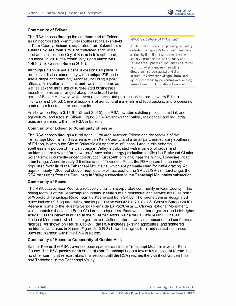
What is a Sphere of Influence?
A sphere of influence is a planning boundary outside of an agency’s legal boundary (such as the city limit line) that designates the agency’s probable future boundary and service area. Spheres of influence ensure the provision of efficient services while discouraging urban sprawl and the premature conversion of agricultural and open space lands by preventing overlapping jurisdictions and duplication of services.
As shown on Figure 3.13-B-1 (Sheet 2 of 3), the RSA includes existing public, industrial, and agricultural land uses in Edison. Figure 3.13-B-2 shows that public, residential, and industrial uses are planned within the RSA in Edison.
Community of Edison to Community of Keene
The RSA passes through a rural agricultural area between Edison and the foothills of the Tehachapi Mountains. This area is within Kern County, and a small part, immediately southeast of Edison, is within the City of Bakersfield’s sphere of influence. Land in this extreme southeastern portion of the San Joaquin Valley is cultivated with a variety of crops, and residences are few and far between. A new solar energy production facility (the Redwood Cluster Solar Farm) is currently under construction just south of SR 58 near the SR 58/Towerline Road interchange. Approximately 2.5 miles east of Towerline Road, the RSA enters the sparsely populated foothills of the Tehachapi Mountains, which are primarily used for cattle grazing. At approximately 1,800 feet above mean sea level, just east of the SR 223/SR 58 interchange, the RSA transitions from the San Joaquin Valley subsection to the Tehachapi Mountains subsection.
Community of Keene
The RSA passes near Keene, a relatively small unincorporated community in Kern County in the rolling foothills of the Tehachapi Mountains. Keene’s main residential and service area lies north of Woodford-Tehachapi Road near the Keene exit from SR 58. The Keene census designated place includes 9.7 square miles, and its population was 431 in 2010 (U.S. Census Bureau 2010). Keene is home to the Nuestra Señora Reina de La Paz/César E. Chávez National Monument, which contains the United Farm Workers headquarters. Renowned labor organizer and civil rights activist César Chávez is buried at the Nuestra Señora Reina de La Paz/César E. Chávez National Monument, which has a garden and visitor center as well as a museum and conference facilities. As shown on Figure 3.13-B-1, the RSA includes existing agricultural and scattered residential land uses in Keene. Figure 3.13-B-2 shows that agricultural and natural resources uses are planned within the RSA in Keene.
Community of Keene to Community of Golden Hills
East of Keene, the RSA traverses open space areas in the Tehachapi Mountains within Kern County. The RSA passes north of the historic Tehachapi Loop a few miles outside of Keene, but no other communities exist along this section until the RSA reaches the vicinity of Golden Hills and Tehachapi in the Tehachapi Valley.
Section 3.13 Station Planning, Land Use, and Development
California High-Speed Rail Authority February 2020
Bakersfield to Palmdale Project Section Administrative Draft Project EIR/EIS Page | 3.13-15
Community of Golden Hills
The RSA passes just northeast of Golden Hills, an unincorporated community in Kern County on the west side of SR 58 and north-northwest of Tehachapi. According to the 2010 Census, the Golden Hills census designated place included 12.3 square miles and had a population of 8,656 in 2010 (U.S. Census Bureau 2010). Golden Hills is an unincorporated development originally subdivided in the late 1960s and early 1970s as a recreational second-home community. The community is characterized by large-lot, equestrian-oriented residential development with a small commercial area along SR 202 between Woodford-Tehachapi Road and Golden Hills Boulevard. As shown on Figure 3.13-B-1, the RSA includes undeveloped areas along SR 58, just beyond the community’s northeast boundary.
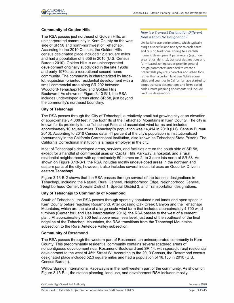
How is a Transect Designation Different from a Land Use Designation? Unlike land use designations, which typically assign a specific land use type to each parcel and rely on traditional zoning to establish numeric development parameters (e.g., floor area ratios, density), transect designations and form-based zoning codes provide general design parameters intended to create a predictable physical character and urban form rather than a certain land use. While some cities and counties in California have started to adopt transect designations and form-based codes, most planning documents still include land use designations.
City of Tehachapi
The RSA passes through the City of Tehachapi, a relatively small but growing city at an elevation of approximately 4,000 feet in the foothills of the Tehachapi Mountains in Kern County. The city is known for its proximity to the Tehachapi Pass and associated wind farms and includes approximately 10 square miles. Tehachapi’s population was 14,414 in 2010 (U.S. Census Bureau 2010). According to 2010 Census data, 41 percent of the city’s population is institutionalized (presumably in the California Correctional Institution, also known as Tehachapi State Prison). The California Correctional Institution is a major employer in the city.
Most of Tehachapi’s developed areas, services, and facilities are on the south side of SR 58, except for a handful of commercial uses on Capital Hills Parkway, a hospital, and a rural residential neighborhood with approximately 50 homes on 2- to 3-acre lots north of SR 58. As shown on Figure 3.13-B-1, the RSA includes mostly undeveloped areas in the northern and eastern parts of the city; however, it also includes several industrial uses on Goodrick Drive in eastern Tehachapi.
Figure 3.13-B-2 shows that the RSA passes through several of the transect designations in Tehachapi, including the Natural, Rural General, Neighborhood Edge, Neighborhood General, Neighborhood Center, Special District 1, Special District 3, and Transportation designations.
City of Tehachapi to Community of Rosamond
South of Tehachapi, the RSA passes through sparsely populated rural lands and open space in Kern County before reaching Rosamond. After crossing Oak Creek Canyon and the Tehachapi Mountains, which are the site of a large-scale wind farm that includes approximately 4,700 wind turbines (Center for Land Use Interpretation 2016), the RSA passes to the west of a cement plant. At approximately 3,800 feet above mean sea level, just east of the southeast of the final ridgeline of the Tehachapi Mountains, the RSA transitions from the Tehachapi Mountains subsection to the Rural Antelope Valley subsection.
Community of Rosamond
The RSA passes through the western part of Rosamond, an unincorporated community in Kern County. This predominantly residential community contains several scattered areas of noncontiguous development near Rosamond Boulevard and SR 14, with sporadic rural residential development to the west of 45th Street W. According to the 2010 Census, the Rosamond census designated place included 52.3 square miles and had a population of 18,150 in 2010 (U.S. Census Bureau).
Willow Springs International Raceway is in the northwestern part of the community. As shown on Figure 3.13-B-1, the station planning, land use, and development RSA includes mostly
Section 3.13 Station Planning, Land Use, and Development
February 2020 California High-Speed Rail Authority
3.13-16 | Page Bakersfield to Palmdale Project Section Administrative Draft Project EIR/EIS
undeveloped areas and agricultural land uses in the western part of the community, except for several rural residential uses near 60th Street W and Rosamond Boulevard. Figure 3.13-B-2 shows that most of the land within the RSA in Rosamond is planned for natural resource uses; however, industrial, multifamily residential, and commercial uses are planned between Rosamond Boulevard and Gaskell Road.
Community of Rosamond to City of Lancaster
South of Rosamond, the RSA enters Los Angeles County at Avenue A. It passes through mostly undeveloped areas with scattered nearby residential land uses, including a mobile home park southeast of SR 14 and Avenue E, before reaching Lancaster.
City of Lancaster
The RSA passes through the City of Lancaster in Los Angeles County. South of Avenue H, the RSA enters a developed urban area and transitions from the Rural Antelope Valley subsection to the Urban Antelope Valley subsection.
According to the 2010 Census, the City of Lancaster included 94.5 square miles and had a population of 156,633 in 2010 (U.S. Census Bureau). As shown on Figure 3.13-B-1, the RSA includes a mix of existing residential, commercial, industrial, and public uses in Lancaster along with the existing UPRR right-of-way, which is used by freight traffic and the Metrolink commuter rail system.
As shown on Figure 3.13-B-2, planned land uses in the in Lancaster primarily consist of commercial and industrial uses, with a small amount of multifamily residential uses on the west side of Sierra Highway between Avenues H and K.
City of Palmdale
According to the 2010 Census, the City of Palmdale included 106.2 square miles and had a population of 152,750 (U.S. Census Bureau 2010).
Bakersfield to Palmdale Project Section Build Alternatives
The B-P Build Alternatives extend south to Avenue O in the City of Palmdale along the existing UPRR right-of-way. As shown on Figure 3.13-B-1, most of the land in the RSA north of Avenue O remains undeveloped, except for some scattered commercial and industrial uses. U.S. Air Force Plant 42 is east of the B-P Build Alternative alignments between Avenue M and Avenue O. Figure 3.13-B-2 shows that the land in the RSA on the west side of Sierra Highway between Avenue M and Avenue O is planned for commercial uses, whereas the land on the opposite side of Sierra Highway is planned for industrial uses.
Palmdale Station Site
The RSA for the proposed Palmdale Station site begins at Avenue O on the north side of Palmdale and terminates north of Avenue S. The following describes the land uses adjacent to the alignment from north to south. The entire length of the proposed alignment would be adjacent to or within the existing UPRR right-of-way.
The segment of the alignment between Avenue O and the Palmdale Station passes through industrial, residential, commercial, and public land uses south of Avenue O. The Palmdale Station would be along the proposed HSR alignment parallel to Sierra Highway, and the existing Palmdale Transportation Center would be expanded to the north to accommodate the HSR system. It would be bounded by E Avenue Q to the north and Palmdale Boulevard to the south. The area surrounding the Palmdale Station site is characterized by residential, commercial, industrial, and institutional uses and vacant land. Planned land uses near the Palmdale Station site include commercial and industrial uses and a specific plan.
Section 3.13 Station Planning, Land Use, and Development
California High-Speed Rail Authority February 2020
Bakersfield to Palmdale Project Section Administrative Draft Project EIR/EIS Page | 3.13-17
3.13.6 Environmental Consequences This section describes the HSR project’s environmental consequences related to station planning, land use, and development. Section 3.13.7, Mitigation Measures, provides a list of mitigation measures intended to address the station planning, land use, and development impacts.
3.13.6.1 No Project Alternative The No Project Alternative includes many planned projects that would likely be implemented by 2040. Chapter 2, Alternatives, describes the No Project Alternative. Section 3.19, Cumulative Impacts, provides foreseeable future development projects in the Bakersfield to Palmdale Project Section that could affect land use, including transportation changes. These projects include shopping centers, solar farms, small and large residential developments, office buildings/complexes, restaurants, hotels, a hospital, a truck stop, industrial facilities, and transportation projects.
The land use elements of the Bakersfield, Tehachapi, Lancaster, and Palmdale General Plans encourage infill and higher-density development in urban areas and concentration of uses around transit corridors to provide more modal choices for residents and workers; however, those planning documents also allow lower-density suburban-style development along the edges of those communities. These policies are being implemented in the region regardless of whether the B-P Build Alternatives are constructed. Under the No Project Alternative, new housing and commercial development would accommodate the projected population and employment growth.
Under the No Project Alternative, the 2014 RTP/SCS adopted by the Kern Council of Governments and the 2016 RTP/SCS adopted by the Southern California Association of Governments would encourage both compact development and greater investment in local transit modes as a means of reducing greenhouse gas emissions. These plans include provisions aimed at reducing these emissions and are considered by cities and counties during planning and zoning deliberations in order to comply with the CEQA requirement to mitigate the impacts of planning and zoning decisions on greenhouse gas emissions.
The general plans of Bakersfield and Palmdale include goals and policies that support development of an HSR system to achieve their economic development goals. Overall, the No Project Alternative would not be as strong a catalyst for the development envisioned in these general plans and other planning documents as would the B-P Build Alternatives. Therefore, the No Project Alternative would be inconsistent with these plans.
3.13.6.2 Bakersfield Station—Fresno to Bakersfield Locally Generated Alternative from the Intersection of 34th Street and L Street to Oswell Street
As described in Section 2.4.2.2, the EIR/EIS summarizes the results of analysis included in the Fresno to Bakersfield Section Draft Supplemental EIR/EIS (Authority and FRA 2017) and Final Supplemental EIR (Authority 2018b) for the portion of the F-B LGA from the intersection of 34th Street and L Street to Oswell Street, as well as the results of technical studies related to this portion of the F-B LGA. The following is a summary discussion of information for the Bakersfield Station F-B LGA analysis.
Construction Impacts
Impact LU #1: Potential for Construction to Temporarily Alter Existing Land Use Patterns
The portion of the F-B LGA from the intersection of 34th Street and L Street to Oswell Street would require temporary closure of rural roads to construct overpasses and underpasses across the HSR system. Construction of this portion of the F-B LGA would not cause adjacent land to temporarily change uses. CEQA Conclusion The effect of the temporary use of land for project construction staging, laydown, and fabrication would be less than significant under CEQA.
Section 3.13 Station Planning, Land Use, and Development
February 2020 California High-Speed Rail Authority
3.13-18 | Page Bakersfield to Palmdale Project Section Administrative Draft Project EIR/EIS
Impact LU #2: Potential for Construction to Permanently Alter Existing Land Use Patterns
Construction of the portion of the F-B LGA alignment from the intersection of 34th Street and L Street to Oswell Street would temporarily use approximately 54 acres of land outside of the permanent project footprint for construction staging, laydown, and fabrication areas. Similar to the Hybrid Alternative’s impacts, lands used for temporary construction would be acquired from willing landowners and restored to their previous condition at the end of the construction period, long-term land uses would not change, adjacent land uses would not change, and there would not be a substantial change in the long-term pattern or intensity of land use inconsistent with adjacent land uses. CEQA Conclusion The effect of the temporary use of land for project construction staging, laydown, and fabrication would be less than significant under CEQA.
Impact LU #3: Permanent Conversion of Existing and Planned Land Uses to Transportation Use
The F Street Station site would also result in permanent conversion of land in other uses to transportation-related uses. The station site would be on land designated for current commercial, industrial, and transportation-related uses and adjacent to lands zoned for industrial use. The direct conversion of this land would substantially change the intensity and pattern of land uses. The station site is currently bounded by an irrigation canal, the UPRR, Chester Avenue, and Golden State Avenue (SR 204/99 Business). Because the adjacent land uses are either transportation-related or a community facility, the station would not cause a substantial change in the pattern or intensity of adjacent land use that would be inconsistent with existing land uses. Further, lands adjacent to the station site are in urbanized areas that could sustain and potentially benefit from increased connectivity of a transportation center.
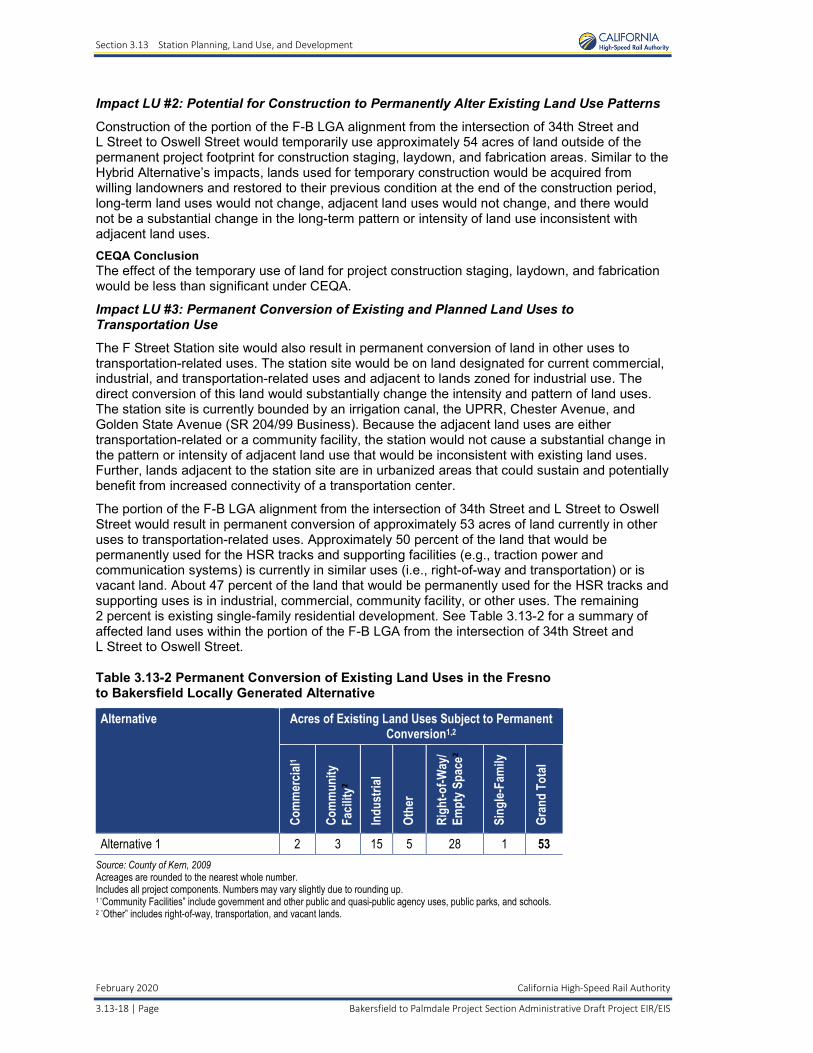
The portion of the F-B LGA alignment from the intersection of 34th Street and L Street to Oswell Street would result in permanent conversion of approximately 53 acres of land currently in other uses to transportation-related uses. Approximately 50 percent of the land that would be permanently used for the HSR tracks and supporting facilities (e.g., traction power and communication systems) is currently in similar uses (i.e., right-of-way and transportation) or is vacant land. About 47 percent of the land that would be permanently used for the HSR tracks and supporting uses is in industrial, commercial, community facility, or other uses. The remaining 2 percent is existing single-family residential development. See Table 3.13-2 for a summary of affected land uses within the portion of the F-B LGA from the intersection of 34th Street and L Street to Oswell Street.
Table 3.13-2 Permanent Conversion of Existing Land Uses in the Fresno to Bakersfield Locally Generated Alternative
Alternative Acres of Existing Land Uses Subject to PermanentConversion1,2
Com
mer
cial1
Com
mun
ity
Facil
ity2
Indu
stria
l
Othe
r
Righ
t-of-W
ay/
Empt
y Spa
ce2
Sing
le-Fa
mily
Gran
d To
tal
Alternative 1 2 3 15 5 28 1 53 Source: County of Kern, 2009 Acreages are rounded to the nearest whole number. Includes all project components. Numbers may vary slightly due to rounding up. 1 “Community Facilities” include government and other public and quasi-public agency uses, public parks, and schools. 2 “Other” includes right-of-way, transportation, and vacant lands.
Section 3.13 Station Planning, Land Use, and Development
California High-Speed Rail Authority February 2020
Bakersfield to Palmdale Project Section Administrative Draft Project EIR/EIS Page | 3.13-19
CEQA Conclusion Because the alignment would be adjacent to the UPRR tracks, the conversion of industrial and commercial land would not substantially change the pattern and intensity of the use of adjacent land and would be consistent with adjacent land uses. Therefore, the land use impacts would be less than significant under CEQA.
Impact LU #4: Potential for Construction to Permanently Disrupt Planned Development
The proposed F Street Station site could induce residential and commercial infill development, as envisioned in the Metropolitan Bakersfield General Plan, by providing an economic driver for such development. The proposed F Street Station site could encourage more efficient land use patterns that are consistent with Bakersfield’s planning goals (refer to the Fresno to Bakersfield Section Draft Supplemental EIR/EIS [Authority and FRA 2017] and Fresno to Bakersfield Section Final Supplemental EIR [Authority 2018b] for more detailed analysis).
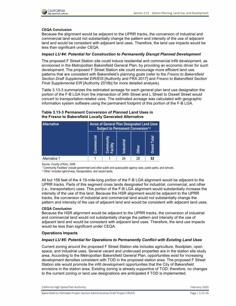
Table 3.13-3 summarizes the estimated acreage for each general plan land use designation the portion of the F-B LGA from the intersection of 34th Street and L Street to Oswell Street would convert to transportation-related uses. The estimated acreage was calculated with geographic information system software using the permanent footprint of this portion of the F-B LGA.
Table 3.13-3 Permanent Conversion of Planned Land Uses in the Fresno to Bakersfield Locally Generated Alternative
Alternative Acres of General Plan Designated Land UsesSubject to Permanent Conversion1,2
Com
mer
cial
Com
mun
ity
Facil
ity
Indu
stria
l
Othe
r
Gran
d To
tal
Alternative 1 1 1 24 28 53 Source: County of Kern, 2009 1 “Community Facilities” include government and other public and quasi-public agency uses, public parks, and schools. 2 “Other” includes right-of-way, transportation, and vacant lands.
All but 158 feet of the 4.19-mile-long portion of the F-B LGA alignment would be adjacent to the UPRR tracks. Parts of this segment cross lands designated for industrial, commercial, and other (i.e., transportation) uses. This portion of the F-B LGA alignment would substantially increase the intensity of the use of this land. Because the HSR alignment would be adjacent to the UPRR tracks, the conversion of industrial and commercial land would not substantially change the pattern and intensity of the use of adjacent land and would be consistent with adjacent land uses. CEQA Conclusion Because the HSR alignment would be adjacent to the UPRR tracks, the conversion of industrial and commercial land would not substantially change the pattern and intensity of the use of adjacent land and would be consistent with adjacent land uses. Therefore, the land use impacts would be less than significant under CEQA.
Operations Impacts
Impact LU #5: Potential for Operations to Permanently Conflict with Existing Land Uses
Current zoning around the proposed F Street Station site includes agriculture, floodplain, open space, and industrial uses. Several vacant and underused properties are in the station site study area. According to the Metropolitan Bakersfield General Plan, opportunities exist for increasing development densities consistent with TOD in the proposed station area. The proposed F Street Station site would promote the infill development opportunities that the City of Bakersfield envisions in the station area. Existing zoning is already supportive of TOD; therefore, no changes to the current zoning or land use designations are anticipated if TOD is implemented.
Section 3.13 Station Planning, Land Use, and Development
February 2020 California High-Speed Rail Authority
3.13-20 | Page Bakersfield to Palmdale Project Section Administrative Draft Project EIR/EIS
The proposed F Street Station near downtown Bakersfield would encourage higher-intensity development in the surrounding areas, but this indirect effect would be consistent with existing zoning and land use goals for the downtown area. The proposed F Street Station site could encourage more efficient land use patterns that are consistent with Bakersfield’s planning goals (refer to the Fresno to Bakersfield Section Draft Supplemental EIR/EIS [Authority and FRA 2017] and Fresno to Bakersfield Section Final Supplemental EIR [Authority 2018b] for more detailed analysis). CEQA Conclusion This portion of the F-B LGA alignment would not be disruptive enough to force a change in land use patterns. Therefore, this portion of the F-B LGA would not have an indirect land use impact under CEQA.
3.13.6.3 Palmdale Station Site Construction Impacts
Impact LU #1: Potential for Construction to Temporarily Alter Existing Land Use Patterns
Generally, construction would cause temporary and intermittent disruption of access to some properties. Some businesses adjacent to the station site could experience hardship during construction due to access disruptions. In addition, some businesses in urban areas could experience hardship due to traffic congestion associated with nearby roadwork. Any access disruptions would be temporary and would not convert existing land uses to transportation use.
During the construction period, the Palmdale Station site would require the temporary use of land for construction activities and would result in indirect temporary effects on adjacent land uses. Implementation of LU-IAMF#3 would ensure that temporary construction areas are returned to pre-construction conditions and do not create post-construction land use and community consistency concerns.
Construction activities would result in temporary increases in noise levels, dust, and visual changes. These changes would temporarily inconvenience residents in Palmdale, primarily within approximately 500 feet of the temporary footprint for the Palmdale Station site. Any increases in noise levels, dust, and visual changes would be temporary and would not require conversion of existing land uses to transportation use. Additionally, construction would cause temporary and intermittent disruption of access to some properties. Some businesses in the immediate vicinity of the Palmdale Station site could experience hardship due to traffic congestion associated with nearby roadwork. The HSR project’s temporary impacts related to noise and air quality would be minimized through implementation of NV-IAMF#1, AQ-IAMF#1, and AQ-IAMF#2.
Implementation of the IAMFs described above would minimize the potential for construction of the Palmdale Station site to alter existing land use patterns; however, some residual impacts would remain. CEQA Conclusion As discussed above, construction of the Palmdale Station site would result in temporary increases in noise levels, dust, and visual changes, and temporary impacts on access to park facilities. However, these impacts would not result in potentially significant impacts related to temporary changes to land use patterns that would be inconsistent with adjacent land uses under CEQA.
Impact LU #2: Potential for Construction to Permanently Alter Existing Land Use Patterns
Construction of the Palmdale Station site would require a large number of temporary construction employees but would not have any negative effects related to temporary population increases or the need for increased housing. Unemployment in the area remains relatively high, so project-related jobs may be filled by current residents in the region who have the required skills. With the available supply of workers, the increase of construction workers would not permanently convert adjacent existing land uses to transportation use.
Section 3.13 Station Planning, Land Use, and Development
California High-Speed Rail Authority February 2020
Bakersfield to Palmdale Project Section Administrative Draft Project EIR/EIS Page | 3.13-21
Similar to the station sites in Bakersfield contemplated as part of the Hybrid Alternative and the LGA, construction of the Palmdale Station could encourage demand for increased land use densities and TOD near the station site. Any future changes in the allowable development types or intensities in the station area would be subject to a separate environmental review and public decision-making process undertaken by the City of Palmdale. If there is not a comprehensive planning process at the local level, construction of the Palmdale Station site could alter existing land use patterns in such a way that the surrounding community would be disrupted and the surrounding land uses would be inconsistent.
The HSR project’s permanent impacts related to station area land use inconsistencies would be minimized through compliance with LU-IAMF#2 (Station Area Planning and Local Agency Coordination) and LU-IAMF#1 (HSR Station Area Development General Principles and Guidelines).
LU-IAMF#2 would reduce potential impacts related to station-area land use inconsistencies and provide benefits related to station planning by coordinating with local agencies to prepare the station area for HSR operations. In partnership with the Authority, local agencies would plan for and encourage multimodal hubs, promote value capture at and around stations, and advance TOD strategies to support station areas that are mixed-use, are pedestrian-accessible, and have HSR-supportive development. The Authority is committed to working with host cities and other local agencies throughout the process, in a cooperative manner, sharing data and information to enable each station area to benefit from the efforts and successes at other stations.
LU-IAMF#1 would reduce potential impacts related to station-area land use inconsistencies and provide benefits related to station planning by implementing the Authority’s station-area development principals and guidelines, which would minimize land consumption needs for new growth, enhance joint development opportunities at or near stations, and support a comprehensive and extensive local transit and shuttle system, bicycle and pedestrian paths, and related amenities that can serve the local communities as well as provide access to and egress from HSR stations. The Authority is committed to cooperating with local communities to develop HSR stations appropriate to the scale and needs of each community.
Additional consequences of construction of the Palmdale Station site include changes to the visual character of the area and visual impacts on sensitive land uses, particularly residential, commercial, and public uses (refer to Section 3.16, Aesthetics and Visual Quality, for additional information).
Construction of the Palmdale Station site would also result in approximately 312 residential and 192 business displacements, as well as the displacement of a community facility. Refer to the discussion for Impacts SO #3, SO #4, and SO #7 in Section 3.12.6 of this EIR/EIS for additional information regarding the potential residential, business, and community facility displacements associated with the Palmdale Station site, respectively.
The Palmdale Station site’s permanent impacts related to displacements and relocations would be minimized through compliance with SOCIO-IAMF#2 (Compliance with Uniform Relocation Assistance and Real Property Acquisition Policies Act) and SOCIO-IAMF#3 (Relocation Mitigation Plan).
Implementation of the IAMFs described above would minimize the potential for construction of the Palmdale Station site to permanently alter existing land use patterns and would create some benefits. The remaining land use inconsistencies could result in changes to existing land use patterns on adjacent land.
Despite all of the Palmdale Station site’s benefits, its construction would still result in impacts related to permanent changes to visual character and views for residential and public uses (schools). However, these visual impacts would not result in changes in existing land use patterns on adjacent land.
Construction of the Palmdale Station site could lead to long-term land use changes in the station area by maximizing station area development and ensuring that it would be complementary to the
Section 3.13 Station Planning, Land Use, and Development
February 2020 California High-Speed Rail Authority
3.13-22 | Page Bakersfield to Palmdale Project Section Administrative Draft Project EIR/EIS
HSR project while also being consistent with the scale and needs of each community. The land use harmonization that could result from construction of the Palmdale Station site would further the TOD goals of the Palmdale Transit Village Specific Plan area. CEQA Conclusion As discussed above, construction of the Palmdale Station site would result in permanent changes to visual character and views and could encourage demand for increased land use densities and TOD near the station site.
While any future changes in the allowable development types or intensities in the station area would be subject to a separate environmental review and public decision-making process undertaken by the City of Palmdale, construction of the Palmdale Station site could alter existing land use patterns in such a way that the surrounding community would be disrupted and the surrounding land uses would be inconsistent unless a comprehensive plan is in place to ensure land use conflicts are minimized.
Implementation of LU-IAMF#1 and LU-IAMF#2 would reduce the Palmdale Station’s impacts on existing land use patterns by ensuring that the station would be consistent with surrounding development and vice versa.
Implementation of the IAMFs described above would minimize the potential for construction of the Palmdale Station site to cause a substantial change in land use patterns and would create some benefits. Therefore, construction of the Palmdale Station site would result in less than significant impacts related to changes in land use patterns under CEQA.
Impact LU #3: Permanent Conversion of Existing and Planned Land Uses to Transportation Use
The Palmdale Station site would require the permanent conversion of land and could have both direct and indirect effects on adjacent land uses that could cause additional conversion of land uses to transportation use.
The Palmdale Station site would result in the permanent conversion of approximately 528 acres of land to transportation use. Table 3.13-3, provided under Impact LU #3 for the B-P Build Alternatives, shows the total acres of existing land uses estimated to be permanently impacted by the station site by land use type. Most of the land anticipated to be permanently converted to transportation land use is currently vacant. Railroad/utility land uses account for the subsequent greatest conversion of existing land uses to transportation land use. Overall, the construction of the station site would convert a total of approximately 186 acres of existing land uses (not including vacant land) to transportation use.
As discussed above under Impact LU #3 for the B-P Build Alternatives, the potential for construction of the Palmdale Station site to permanently convert existing and planned land uses outside the permanent footprint would be minimized if some of the land outside the area required for operation and maintenance is declared to be excess by the Authority and sold/exchanged in compliance with the procedures set forth in Public Utilities Code Section 185040.
Compliance with Public Utilities Code Section 185040 would not minimize any of the effects associated with the conversion of land within the permanent footprint. Because the Palmdale Station site could result in changes to existing land use patterns on adjacent land and could permanently convert land to uses that would not be consistent with applicable local land use plans, some residual impacts would remain.
Shifting the location of the Palmdale Station site would still result in the permanent conversion of existing and planned land uses. Therefore, no feasible mitigation exists to minimize or mitigate the direct conversion of existing and planned land uses related to the Palmdale Station site. CEQA Conclusion As described above, compliance with Public Utilities Code Section 185040 would minimize the potential for construction of the Palmdale Station site to permanently convert existing and planned land uses outside of the permanent footprint. Additionally, the direct physical conversion
Section 3.13 Station Planning, Land Use, and Development
California High-Speed Rail Authority February 2020
Bakersfield to Palmdale Project Section Administrative Draft Project EIR/EIS Page | 3.13-23
of land use required to construct the Palmdale Station site itself would not result in any indirect land use conversion during construction. Therefore, the permanent conversion of existing and planned land uses during construction would not cause a substantial change in land use patterns inconsistent with adjacent land uses. The impact under CEQA would be less than significant. Therefore, CEQA does not require mitigation.
Impact LU #4: Potential for Construction to Permanently Disrupt Planned Development
As shown in Table 3.13-4, provided under Impact LU #3 for the B-P Build Alternatives, construction of the Palmdale Station site would result in the direct and permanent conversion of approximately 529 acres of land planned for nontransportation uses.
Additionally, some temporary conversions of land planned for nontransportation uses could occur. If the construction staging areas associated with the Palmdale Station site that are currently vacant are not returned to their original condition after completion of the project, owners of those properties could be required to complete additional earthwork and site preparation activities.
The HSR project’s permanent impacts related to the temporary use of construction and staging areas would be minimized through compliance with LU-IAMF#3 (Restoration of Land Used Temporarily During Construction). This IAMF would reduce potential impacts related to the temporary use of construction and staging areas by requiring land used temporarily during construction to be returned to a condition equal to the pre-construction staging condition. Implementation of LU-IAMF#3 would ensure that temporary construction areas are (1) returned to pre-construction conditions and (2) do not preclude future development.
Although the Authority is not aware of any currently proposed project within the proposed station footprint, construction of the Palmdale Station site could result in disruptions to planned development in Palmdale, especially within the planned project footprint. This could require adjustments to planned projects on a local level to ensure that urban design elements of planned projects are integrated with design elements of the Palmdale Station site.
The Palmdale Station site’s permanent impacts related to the disruption of planned development would be minimized through implementation of LU-IAMF#2 (Station Area Planning and Local Agency Coordination). This IAMF would reduce potential impacts related to the disruption of planned development by facilitating the reconfiguration of planned development projects so they no longer conflict with the HSR project.
Implementation of the IAMFs described above would minimize the potential for construction of the Palmdale Station site to permanently disrupt future planned development; however, some residual impacts associated with the construction of the Palmdale Station site would remain. CEQA Conclusion With implementation of the above-stated IAMFs during construction of the Palmdale Station site, construction would not permanently disrupt planned development. The impact under CEQA would be less than significant. Therefore, CEQA does not require any mitigation.
Operations Impacts
Impact LU #5: Potential for Operations to Permanently Conflict with Existing Land Uses
Operation of the Palmdale Station is not anticipated to result in increased noise levels experienced by any adjacent land uses (refer to Section 3.4, Noise and Vibration, for additional information). Operation of the Palmdale Station site could generate electromagnetic fields that could interfere with older, magnetically sensitive imaging equipment. However, none of the medical facilities that could be impacted by the Palmdale Station site currently house magnetically sensitive imaging equipment. Therefore, any electromagnetic fields generated by operation of the Palmdale Station site would not result in permanent land use conflicts.
Operation of the Palmdale Station site would not result in any permanent conflicts with adjacent land uses because it would be designed to complement surrounding land uses. Over time, vacant land surrounding the Palmdale Station site is anticipated to develop with dense TOD-style
Section 3.13 Station Planning, Land Use, and Development
February 2020 California High-Speed Rail Authority
3.13-24 | Page Bakersfield to Palmdale Project Section Administrative Draft Project EIR/EIS
development projects that would maximize the accessibility benefits related to their close proximity to the new station. CEQA Conclusion As discussed above, the Palmdale Station site would not result in permanent land use conflicts Therefore, operation of the Palmdale Station site would result in less than significant impacts related to changes in land use patterns under CEQA.
3.13.6.4 Bakersfield to Palmdale Project Section Build Alternatives This section evaluates the direct and indirect impacts associated with station planning, land use, and development that would result from construction and operation of the Bakersfield to Palmdale Project Section. Impacts are assessed after consideration of IAMFs but before consideration of the project mitigation measures identified in Section 3.13.7.
Construction Impacts
All B-P Build Alternatives (including the CCNM Design Option and the Refined CCNM Design Option) would affect land uses during construction, albeit in potentially different ways. Construction can cause hardship on adjacent businesses and residents, and may temporarily influence land use activities. Also, the project would require temporary construction easements on land for project construction.
Impact LU #1: Potential for Construction to Temporarily Alter Existing Land Use Patterns
During the construction period, the B-P Build Alternatives would require the temporary use of land for construction activities and would result in indirect temporary impacts on adjacent land uses. Overall, the construction impacts would be largely the same for all B-P Build Alternatives.
Construction activities would result in temporary increases in noise levels, dust, and visual changes. These changes would temporarily inconvenience residents along the B-P Build Alternative alignments, primarily in the Northeast Bakersfield District, Tehachapi, Lancaster, and Palmdale, as well as rural residents within approximately 500 feet of the temporary footprint for the B-P Build Alternatives. As discussed under Impact AG-3 in Section 3.14, Agricultural Farmland and Forest Land, construction of the B-P Build Alternatives would not affect livestock grazing operations, including in areas near the proposed portal locations, because it would not result in unacceptable noise and vibration levels on livestock in a confined area (affected livestock could move away from noise and vibration sources). Any increases in noise levels, dust, and visual changes would be temporary; therefore, none of the construction activities associated with the B-P Build Alternatives are anticipated to temporarily alter land use patterns.
Construction would cause temporary and intermittent disruption of access to some properties. Some businesses adjacent to the right-of-way could experience hardship during construction due to access disruptions. In addition, some businesses in urban areas could experience hardship due to traffic congestion associated with nearby roadwork. Any access disruptions would be temporary and are not anticipated to temporarily alter existing land use patterns.
Construction of the B-P Build Alternatives would require using a large number of temporary construction employees, but would not have any negative impacts related to temporary population increases or the need for increased housing. Unemployment in the area remains relatively high, so project-related jobs are expected to be filled by current residents in the region who have the required skills. With the available supply of workers, the increase of construction workers is not anticipated to temporarily alter existing land use patterns.
Approximately 59 miles of the B-P Build Alternative alignments are not adjacent to existing railroads. These parts of the alignments would primarily traverse vacant and/or nearby farmland and could disrupt farm and grazing operations during construction. Table 3.13-4 shows the acreage of land that would be subject to temporary conversion by existing land use type for the B-P Build Alternatives, the Lancaster North B MOWF site, the Avenue M LMF Zone, and the Palmdale Station area. The impacted acreage totals in Table 3.13-4 include the land near the tunnel portal areas that would be temporarily used to construct the project. Depending on the B-P
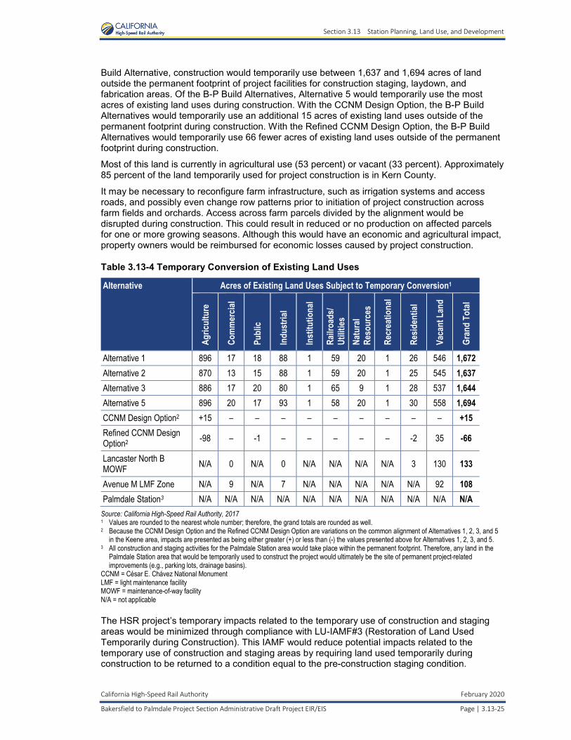
Section 3.13 Station Planning, Land Use, and Development
California High-Speed Rail Authority February 2020
Bakersfield to Palmdale Project Section Administrative Draft Project EIR/EIS Page | 3.13-25
Build Alternative, construction would temporarily use between 1,637 and 1,694 acres of land outside the permanent footprint of project facilities for construction staging, laydown, and fabrication areas. Of the B-P Build Alternatives, Alternative 5 would temporarily use the most acres of existing land uses during construction. With the CCNM Design Option, the B-P Build Alternatives would temporarily use an additional 15 acres of existing land uses outside of the permanent footprint during construction. With the Refined CCNM Design Option, the B-P Build Alternatives would temporarily use 66 fewer acres of existing land uses outside of the permanent footprint during construction.
Most of this land is currently in agricultural use (53 percent) or vacant (33 percent). Approximately 85 percent of the land temporarily used for project construction is in Kern County.
It may be necessary to reconfigure farm infrastructure, such as irrigation systems and access roads, and possibly even change row patterns prior to initiation of project construction across farm fields and orchards. Access across farm parcels divided by the alignment would be disrupted during construction. This could result in reduced or no production on affected parcels for one or more growing seasons. Although this would have an economic and agricultural impact, property owners would be reimbursed for economic losses caused by project construction.
Table 3.13-4 Temporary Conversion of Existing Land Uses
Alternative Acres of Existing Land Uses Subject to Temporary Conversion1
Agric
ultu
re
Com
mer
cial
Publ
ic
Indu
stria
l
Inst
itutio
nal
Railr
oads
/Ut
ilities
Na
tura
l Re
sour
ces
Recr
eatio
nal
Resid
entia
l
Vaca
nt L
and
Gran
d To
tal
Alternative 1 896 17 18 88 1 59 20 1 26 546 1,672 Alternative 2 870 13 15 88 1 59 20 1 25 545 1,637 Alternative 3 886 17 20 80 1 65 9 1 28 537 1,644 Alternative 5 896 20 17 93 1 58 20 1 30 558 1,694 CCNM Design Option2 +15 – – – – – – – – – +15 Refined CCNM Design Option2 -98 – -1 – – – – – -2 35 -66
Lancaster North B MOWF N/A 0 N/A 0 N/A N/A N/A N/A 3 130 133
Avenue M LMF Zone N/A 9 N/A 7 N/A N/A N/A N/A N/A 92 108 Palmdale Station3 N/A N/A N/A N/A N/A N/A N/A N/A N/A N/A N/A
Source: California High-Speed Rail Authority, 2017 1 Values are rounded to the nearest whole number; therefore, the grand totals are rounded as well. 2 Because the CCNM Design Option and the Refined CCNM Design Option are variations on the common alignment of Alternatives 1, 2, 3, and 5
in the Keene area, impacts are presented as being either greater (+) or less than (-) the values presented above for Alternatives 1, 2, 3, and 5. 3 All construction and staging activities for the Palmdale Station area would take place within the permanent footprint. Therefore, any land in the
Palmdale Station area that would be temporarily used to construct the project would ultimately be the site of permanent project-related improvements (e.g., parking lots, drainage basins).
CCNM = César E. Chávez National Monument LMF = light maintenance facility MOWF = maintenance-of-way facility N/A = not applicable
The HSR project’s temporary impacts related to the temporary use of construction and staging areas would be minimized through compliance with LU-IAMF#3 (Restoration of Land Used Temporarily during Construction). This IAMF would reduce potential impacts related to the temporary use of construction and staging areas by requiring land used temporarily during construction to be returned to a condition equal to the pre-construction staging condition.
Section 3.13 Station Planning, Land Use, and Development
February 2020 California High-Speed Rail Authority
3.13-26 | Page Bakersfield to Palmdale Project Section Administrative Draft Project EIR/EIS
Implementation of LU-IAMF#3 would ensure that temporary construction areas are returned to pre-construction conditions and do not create post-construction land use and community consistency concerns.
The HSR project’s temporary impacts related to noise and air quality would be minimized through compliance with NV-IAMF#1 (Noise and Vibration), AQ-IAMF#1 (Fugitive Dust Emissions), and AQ-IAMF#2 (Selection of Coatings).
As discussed under Impact AG-3 in Section 3.14, Agricultural Farmland and Forest Land, the HSR project’s temporary impacts on farming operations, including livestock grazing near tunnel portal locations, would be minimized through compliance with AG-IAMF#4 (Notification to Agricultural Property Owners) and AG-IAMF#5 (Temporary Livestock and Equipment Crossings), which require written notification to agricultural property owners or leaseholders within and adjacent to the disturbance limits for the HSR project section so they can make operational adjustments to avoid construction impacts associated with temporary utility and infrastructure interruptions. Operational adjustments may include requesting that the contractor provide temporary livestock and/or equipment crossings for the duration of construction.
Although the B-P Build Alternatives would result in a short-term land use that is inconsistent with adjacent land uses, they would not cause adjacent land to temporarily change uses. Implementation of the IAMFs described above would minimize the potential for construction to alter existing land use patterns. CEQA Conclusion As discussed above, construction activities related to the B-P Build Alternatives could result in temporary increases in noise levels, dust, and visual changes that could affect nearby properties. However, these types of impacts would not cause land use changes on adjacent parcels or nearby properties. Therefore, construction of the B-P Build Alternatives would not cause a substantial temporary change in land use patterns inconsistent with adjacent land uses and the impact would be less than significant under CEQA.
Impact LU #2: Potential for Construction to Permanently Alter Existing Land Use Patterns
In addition to the temporary impacts discussed above, the construction of the B-P Build Alternatives would result in permanent changes to visual character and views for residential and public uses (schools). Although visual impacts would occur, they would not result in land use conflicts due to the obstruction of scenic views. Therefore, a change to visual character and views would not impact adjacent land uses. As described in Section 3.16, Aesthetics and Visual Impacts, construction of the B-P Build Alternatives would introduce an elevated double track approximately 60 feet high, with an overhead contact system extending nearly 24 feet above the track, in the unincorporated areas east of Bakersfield along Edison Highway. This aerial track section would be out of scale and inconsistent with the visual character of the residential uses and schools within 0.5 mile of the project footprint (refer to Key Viewpoint 1 in the East Bakersfield Landscape Unit in Section 3.16 for more information).
Construction of the B-P Build Alternatives would introduce large cut slopes in the Tehachapi Mountains, which could result in impacts on visual character by altering views for a small number of ridgetop homes in the community of Golden Hills and approximately 50 one-story, single-family homes in the City of Tehachapi. In addition, the construction of the B-P Build Alternatives would introduce a guideway, a bridge, a berm, and overhead contact system poles that would fully obstruct existing scenic views of the Tehachapi foothills for rural residents within 0.25 mile of the new elements.
Although construction of the B-P Build Alternatives could result in aesthetic and visual impacts on residential uses and/or schools in the unincorporated areas east of Bakersfield, the community of Edison, the community of Golden Hills, the City of Tehachapi, and the community of Rosamond, these impacts would not result in land use conflicts. Construction of the B-P Build Alternatives would result in some residential, business, and community facility displacements. Alternative 5 would generally result in a higher number of displacements than the other B-P Build Alternatives; specifically, Alternative 5 would result in approximately 368 residential and 329 business
Section 3.13 Station Planning, Land Use, and Development
California High-Speed Rail Authority February 2020
Bakersfield to Palmdale Project Section Administrative Draft Project EIR/EIS Page | 3.13-27
displacements, whereas Alternatives 1, 2, and 3 would result in 253 to 255 residential and 311 business displacements. Additionally, Alternative 5 would result in the displacement of 6 community facilities, compared to the 3 facilities displaced under each of the other B-P Build Alternatives. The number of residential and business displacements would be the same with and without the CCNM Design Option and Refined CCNM Design Option. Refer to the discussion of socioeconomics for Impacts SO #3, SO #4, and SO #7 in Section 3.12.6 of this EIR/EIS for additional information regarding the potential residential, business, and community facility displacements associated with the B-P Build Alternatives, respectively.
The HSR project’s permanent impacts related to displacements and relocations would be minimized through compliance with SOCIO-IAMF#2 (Compliance with Uniform Relocation Assistance and Real Property Acquisition Policies Act) and SOCIO-IAMF#3 (Relocation Mitigation Plan).
In addition, construction of the B-P Build Alternatives could cause parcel severance, which could permanently disrupt farm operations and result in some agricultural land being removed from production due to its reduced economic viability. The B-P Build Alternatives would not cause permanent land use changes near the proposed tunnel portal locations by disrupting grazing operations in those areas because livestock would be able to cross over the completed HSR tunnel sections during operation. The HSR project’s permanent impacts related to parcel severance would be minimized through compliance with AG-IAMF#3 (Farmland Consolidation Program) and AG-IAMF#5 (Temporary Livestock and Equipment Crossings).
AG-IAMF#3 (Farmland Consolidation Program) would reduce impacts on agricultural farmland by administering a farmland consolidation program to sell remnant agricultural parcels to neighboring landowners for combining with adjacent farmland properties and continued agricultural productivity. Program implementation would reduce the amount of agricultural lands affected by HSR project construction and operation. AG-IAMF#5 would reduce potential impacts related to agricultural land conversion from construction by providing alignment crossings on public and private roads, thereby avoiding the conversion of Important Farmland to nonagricultural use through the disruption of access to a portion of land currently in agricultural use.
Implementation of the IAMFs described above would minimize the potential for construction of the B-P Build Alternatives to permanently alter existing land use patterns; however, some residual impacts related to agricultural parcel severance would remain. CEQA Conclusion As discussed above, construction of the B-P Build Alternatives would result in permanent changes to visual character and views for residential and public uses (schools). However, these changes would not cause land use changes on adjacent parcels or nearby properties. Therefore, construction of the B-P Build Alternatives would not cause a substantial permanent change in land use patterns inconsistent with adjacent land uses. In addition, construction of the B-P Build Alternatives could cause parcel severance, which could disrupt farm operations. Implementation of the above-stated IAMFs during construction of the B-P Build Alternatives would minimize those impacts. Therefore, construction of any of the B-P Build Alternatives would result in less than significant impacts related to changes in land use patterns under CEQA.
Impact LU #3: Permanent Conversion of Existing and Planned Land Uses to Transportation Use
All B-P Build Alternatives would require the permanent conversion of land and could have indirect impacts on adjacent land uses that could cause additional conversion of land uses to transportation use. However, the total number of acres of existing and planned land uses would differ slightly among the various B-P Build Alternatives.
Table 3.13-5 provides the total acres of existing land uses estimated to be permanently impacted by Alternatives 1, 2, 3, and 5; the CCNM Design Option and Refined CCNM Design Option; the Lancaster North B MOWF site; the Avenue M LMF Zone; and the Palmdale Station area. These permanent impacts are defined as land that would be used permanently for HSR tracks and supporting facilities (e.g., traction power and communication systems). These acreages include
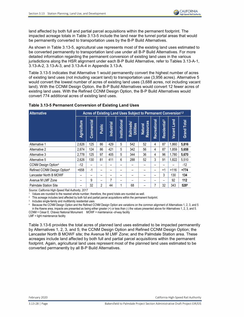
Section 3.13 Station Planning, Land Use, and Development
February 2020 California High-Speed Rail Authority
3.13-28 | Page Bakersfield to Palmdale Project Section Administrative Draft Project EIR/EIS
land affected by both full and partial parcel acquisitions within the permanent footprint. The impacted acreage totals in Table 3.13-5 include the land near the tunnel portal areas that would be permanently converted to transportation uses by the B-P Build Alternatives.
As shown in Table 3.13-5, agricultural use represents most of the existing land uses estimated to be converted permanently to transportation land use under all B-P Build Alternatives. For more detailed information regarding the permanent conversion of existing land uses in the various jurisdictions along the HSR alignment under each B-P Build Alternative, refer to Tables 3.13-A-1, 3.13-A-2, 3.13-A-3, and 3.13-A-4 in Appendix 3.13-A.
Table 3.13-5 indicates that Alternative 1 would permanently convert the highest number of acres of existing land uses (not including vacant land) to transportation use (3,956 acres). Alternative 5 would convert the lowest number of acres of existing land uses (3,688 acres, not including vacant land). With the CCNM Design Option, the B-P Build Alternatives would convert 12 fewer acres of existing land uses. With the Refined CCNM Design Option, the B-P Build Alternatives would convert 774 additional acres of existing land uses.
Table 3.13-5 Permanent Conversion of Existing Land Uses
Alternative Acres of Existing Land Uses Subject to Permanent Conversion1,2
Agric
ultu
re
Com
mer
cial
Publ
ic
Indu
stria
l
Inst
itutio
nal
Railr
oads
/Ut
ilities
Natu
ral
Reso
urce
s
Recr
eatio
nal
Resid
entia
l3
Vaca
nt L
and
Gran
d To
tal
Alternative 1 2,626 125 86 429 5 542 52 4 87 1,860 5,816 Alternative 2 2,674 124 86 421 5 342 56 4 87 1,859 5,658 Alternative 3 2,778 125 97 405 5 344 36 4 96 1,780 5,670 Alternative 5 2,626 130 81 411 6 288 52 3 91 1,822 5,510 CCNM Design Option4 -12 – – – – – – – – – -12 Refined CCNM Design Option4 +658 -1 – – – – – – +1 +116 +774 Lancaster North B MOWF – – – – – – – – 3 130 134 Avenue M LMF Zone – 9 – 7 – – – – – 92 112 Palmdale Station Site – 32 2 44 1 68 – 7 32 343 5284
Source: California High-Speed Rail Authority, 2017 1 Values are rounded to the nearest whole number; therefore, the grand totals are rounded as well. 2 This acreage includes land affected by both full and partial parcel acquisitions within the permanent footprint. 3 Includes single-family and multifamily residential uses. 4 Because the CCNM Design Option and the Refined CCNM Design Option are variations on the common alignment of Alternatives 1, 2, 3, and 5
in the Keene area, impacts are presented as being either greater (+) or less than (-) the values presented above for Alternatives 1, 2, 3, and 5. CCNM = César E. Chávez National Monument MOWF = maintenance -of-way facility LMF = light maintenance facility
Table 3.13-6 provides the total acres of planned land uses estimated to be impacted permanently by Alternatives 1, 2, 3, and 5; the CCNM Design Option and Refined CCNM Design Option; the Lancaster North B MOWF site; the Avenue M LMF Zone; and the Palmdale Station area. These acreages include land affected by both full and partial parcel acquisitions within the permanent footprint. Again, agricultural land uses represent most of the planned land uses estimated to be converted permanently by all B-P Build Alternatives.
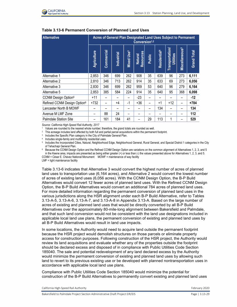
Section 3.13 Station Planning, Land Use, and Development
California High-Speed Rail Authority February 2020
Bakersfield to Palmdale Project Section Administrative Draft Project EIR/EIS Page | 3.13-29
Table 3.13-6 Permanent Conversion of Planned Land Uses
Alternative Acres of General Plan Designated Land Uses Subject to Permanent Conversion1,2
Agric
ultu
re
Com
mer
cial
Indu
stria
l
Mixe
d Us
e3
Natu
ral
Reso
urce
s
Publ
ic
Resid
entia
l4
Tran
spor
tatio
n/Ut
ilities
Misc
ellan
eous
5
Gran
d To
tal
Alternative 1 2,853 346 699 262 908 35 639 96 273 6,111 Alternative 2 2,810 346 713 262 914 35 633 69 273 6,056 Alternative 3 2,830 346 699 262 959 53 640 96 279 6,164 Alternative 5 2,853 385 584 224 914 35 640 95 368 6,098 CCNM Design Option6 +11 – – – -23 – – – – -12 Refined CCNM Design Option6 +732 – +4 -1 +36 – +1 +12 – +784 Lancaster North B MOWF – – – – – – 134 – – 134 Avenue M LMF Zone – 88 24 – – – – – – 112 Palmdale Station Site – 161 184 41 – 29 113 1 – 529
Source: California High-Speed Rail Authority, 2017 1 Values are rounded to the nearest whole number; therefore, the grand totals are rounded as well. 2 This acreage includes land affected by both full and partial parcel acquisitions within the permanent footprint. 3 Includes the Specific Plan category in the City of Palmdale General Plan. 4 Includes single-family and multifamily residential uses. 5 Includes the Incorporated Cities, Natural, Neighborhood Edge, Neighborhood General, Rural General, and Special District 1 categories in the City
of Tehachapi General Plan. 6 Because the CCNM Design Option and the Refined CCNM Design Option are variations on the common alignment of Alternatives 1, 2, 3, and 5
in the Keene area, impacts are presented as being either greater (+) or less than (-) the values presented above for Alternatives 1, 2, 3, and 5. CCNM = César E. Chávez National Monument MOWF = maintenance of way facility LMF = light maintenance facility
Table 3.13-6 indicates that Alternative 3 would convert the highest number of acres of planned land uses to transportation use (6,164 acres), and Alternative 2 would convert the lowest number of acres of existing land uses (6,056 acres). With the CCNM Design Option, the B-P Build Alternatives would convert 12 fewer acres of planned land uses. With the Refined CCNM Design Option, the B-P Build Alternatives would convert an additional 784 acres of planned land uses. For more detailed information regarding the permanent conversion of planned land uses in the various jurisdictions along the HSR alignment under each B-P Build Alternative, refer to Tables 3.13-A-5, 3.13-A-6, 3.13-A-7, and 3.13-A-8 in Appendix 3.13-A. Based on the large number of acres of existing and planned land uses that would be directly converted by all B-P Build Alternatives over the approximately 80-mile-long alignment between Bakersfield and Palmdale, and that such land conversion would not be consistent with the land use designations included in applicable local land use plans, the permanent conversion of existing and planned land uses by all B-P Build Alternatives would result in land use impacts.
In some locations, the Authority would need to acquire land outside the permanent footprint because the HSR project would demolish structures on those parcels or eliminate property access for construction purposes. Following construction of the HSR project, the Authority would review its land acquisitions and evaluate whether any of the properties outside the footprint should be declared excess and disposed of in compliance with Public Utilities Code Section 185040. The sale and potential redevelopment of any land declared excess by the Authority would minimize the permanent conversion of existing and planned land uses by allowing such land to revert to its previous existing use or be developed with planned nontransportation uses in accordance with applicable local land use plans.
Compliance with Public Utilities Code Section 185040 would minimize the potential for construction of the B-P Build Alternatives to permanently convert existing and planned land uses
Section 3.13 Station Planning, Land Use, and Development
February 2020 California High-Speed Rail Authority
3.13-30 | Page Bakersfield to Palmdale Project Section Administrative Draft Project EIR/EIS
outside the permanent footprint; however, compliance with Public Utilities Code Section 185040 would not minimize any of the impacts associated with the conversion of land within the permanent footprint, which represents the vast majority of the land that would be subject to permanent conversion. Therefore, the B-P Build Alternatives could result in changes to existing land use patterns on adjacent land and could permanently convert land to uses that would not be consistent with applicable local land use plans.
What is Public Utilities Code Section 185040?
The Authority may acquire some land outside the permanent footprint because the HSR project would demolish structures on those parcels or eliminate property access; however, such land may not ultimately be necessary for operation and maintenance of the HSR project. California Public Utilities Code Section 185040 sets forth the procedures that the Authority must follow to dispose of any real property that it determines is no longer necessary for HSR purposes (declared excess). Public Utilities Code Section 185040 permits the Authority to sell or exchange the real property or interest therein at fair market value after taking certain actions.
Based on the large number of acres of existing and planned land uses that would be directly converted by all B-P Build Alternatives over the approximately 80-mile-long alignment between Bakersfield and Palmdale, and because such land conversion would not be consistent with the land use designations included in applicable local land use plans, the effects of the B-P Build Alternatives related to the permanent conversion of existing and planned land uses would affect land use at a regional level.
While the Authority may declare some of the land outside the permanent footprint as excess and sell or exchange it, thereby allowing it to revert to its previous existing use or be developed with planned nontransportation uses, many of the effects related to the permanent conversion of existing and planned land uses would remain because some of the land acquired by the Authority outside the permanent footprint may never be sold or exchanged and redeveloped. In addition, the sale and subsequent development/redevelopment of excess properties would not minimize any of the effects associated with the conversion of land within the permanent footprint.
Rerouting the alignment of the B-P Build Alternatives would still result in the permanent conversion of existing and planned land uses. Therefore, no feasible mitigation exists to minimize or mitigate the direct conversion of existing and planned land uses by the HSR project. CEQA Conclusion As described above, compliance with Public Utilities Code Section 185040 would minimize the potential for construction of the B-P Build Alternatives to permanently convert existing and planned land uses outside of the permanent footprint. Additionally, the direct physical conversion of land use required to construct the B-P Build Alternatives would not result in any indirect land use conversion during construction. Therefore, the permanent conversion of existing and planned land uses during construction would not cause a substantial change in land use patterns inconsistent with adjacent land uses. The impact under CEQA would be less than significant. Therefore, CEQA does not require mitigation.
Impact LU #4: Potential for Construction to Permanently Disrupt Planned Development
As shown in Table 3.13-6 under Impact LU #3, construction of the B-P Build Alternatives would result in the direct and permanent conversion of between 6,056 and 6,164 acres of land planned for nontransportation uses, depending on the B-P Build Alternative. In addition to these direct impacts on planned development, all B-P Build Alternatives could disrupt three planned development areas along the alignment. The B-P Build Alternatives would disrupt the planned development areas to the same extent.
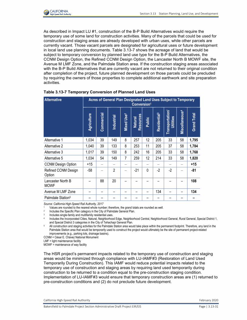
Section 3.13 Station Planning, Land Use, and Development
California High-Speed Rail Authority February 2020
Bakersfield to Palmdale Project Section Administrative Draft Project EIR/EIS Page | 3.13-31
As described in Impact LU #1, construction of the B-P Build Alternatives would require the temporary use of some land for construction activities. Many of the parcels that could be used for construction and staging areas are already developed with urban uses, while other parcels are currently vacant. Those vacant parcels are designated for agricultural uses or future development in local land use planning documents. Table 3.13-7 shows the acreage of land that would be subject to temporary conversion by planned land use type for the B-P Build Alternatives, the CCNM Design Option, the Refined CCNM Design Option, the Lancaster North B MOWF site, the Avenue M LMF Zone, and the Palmdale Station area. If the construction staging areas associated with the B-P Build Alternatives that are currently vacant are not returned to their original condition after completion of the project, future planned development on those parcels could be precluded by requiring the owners of those properties to complete additional earthwork and site preparation activities.
Table 3.13-7 Temporary Conversion of Planned Land Uses
Alternative Acres of General Plan Designated Land Uses Subject to Temporary Conversion1
Agric
ultu
re
Com
mer
cial
Indu
stria
l
Mixe
d Us
e2
Natu
ral
Reso
urce
s
Publ
ic
Resid
entia
l3
Tran
spor
tatio
n/Ut
ilities
Misc
ellan
eous
4
Gran
d To
tal
Alternative 1 1,034 39 149 8 257 12 205 33 58 1,795 Alternative 2 1,040 39 133 8 253 11 205 37 58 1,784 Alternative 3 1,017 39 150 8 242 16 205 33 58 1,768 Alternative 5 1,034 54 149 7 259 12 214 33 58 1,820 CCNM Design Option +15 – – – – – – – – +15 Refined CCNM Design Option
-58 – 2 – -21 0 -2 -2 – -81
Lancaster North B MOWF
– 88 20 – – – – – – 108
Avenue M LMF Zone – – – – – – 134 – – 134 Palmdale Station5 – – – – – – – – – –
Source: California High-Speed Rail Authority, 2017 1 Values are rounded to the nearest whole number; therefore, the grand totals are rounded as well. 2 Includes the Specific Plan category in the City of Palmdale General Plan. 3 Includes single-family and multifamily residential uses. 4 Includes the Incorporated Cities, Natural, Neighborhood Edge, Neighborhood Central, Neighborhood General, Rural General, Special District 1,
and Special District 3 categories in the City of Tehachapi General Plan. 5 All construction and staging activities for the Palmdale Station area would take place within the permanent footprint. Therefore, any land in the
Palmdale Station area that would be temporarily used to construct the project would ultimately be the site of permanent project-related improvements (e.g., parking lots, drainage basins).
CCNM = César E. Chávez National Monument LMF = light maintenance facility MOWF = maintenance of way facility
The HSR project’s permanent impacts related to the temporary use of construction and staging areas would be minimized through compliance with LU-IAMF#3 (Restoration of Land Used Temporarily During Construction). This IAMF would reduce potential impacts related to the temporary use of construction and staging areas by requiring land used temporarily during construction to be returned to a condition equal to the pre-construction staging condition. Implementation of LU-IAMF#3 would ensure that temporary construction areas are (1) returned to pre-construction conditions and (2) do not preclude future development.
Section 3.13 Station Planning, Land Use, and Development
February 2020 California High-Speed Rail Authority
3.13-32 | Page Bakersfield to Palmdale Project Section Administrative Draft Project EIR/EIS
The B-P Build Alternatives would require the acquisition of a small portion of a parcel at the southwest corner of Tehachapi Boulevard/Steuber Road in Tehachapi where a new truck stop is proposed (City of Tehachapi 2016b). According to the site plan for that proposed development, the portion of the parcel that would be acquired is planned for landscaping and truck parking. Although the HSR project could result in the loss of approximately five parking stalls at the proposed truck stop, the loss of those parking stalls is not likely to affect the viability of that development or disrupt the proposed on-site circulation pattern. Further, the site plan for the proposed truck stop could be reconfigured to recoup the lost parking stalls. Therefore, all B-P Build Alternatives could result in a minor disruption to the proposed truck stop.
The B-P Build Alternatives would construct a new HSR line through the northern part of the City of Tehachapi’s sphere of influence. Although part of the B-P Build Alternative alignments would be in a tunnel, the nontunnel portion of the alignments would create a physical barrier to future development in those parts of the city’s planning area to the northeast of the alignments by forcing the city or developer to build expensive new roads around the HSR project to serve that development. Because the affected portions of the city’s planning area are low- to moderate-priority growth areas proposed for low-density development, the potential disruption to future development in this area is limited. Aside from the potential disruption to circulation, none of the B-P Build Alternatives are anticipated to result in potential disruptions to planned low-density development in the affected planning area. Due to its status as a low- to moderate-priority growth area, the affected planning area represents a long-term growth area for the city and is not likely to be developed prior to construction of the HSR project through Tehachapi. Therefore, it is reasonable to assume that any future development in that area would be sited in a manner that would reduce potential land use conflicts with the HSR project.
The B-P Build Alternatives would require the full acquisition of four parcels on the south side of Avenue I between Elm and Beech Avenues in the City of Lancaster that are part of an approved residential tract map. The B-P Build Alternatives would also require temporary construction easements and partial acquisitions on several other parcels that would be part of this planned residential development. In effect, construction of the B-P Build Alternatives would require all of the land required to construct this residential project, which means that the residential project could not move forward. However, that development could move forward if redesigned to fit into the remaining land that would not be incorporated into the right-of-way for the HSR project. For example, the residential project could be redesigned to accommodate fewer units or accommodate the same number of units within a smaller footprint by building vertically. Such redesign could reduce the number of new residential units included as part of the residential project. In addition, indirect impacts (such as noise) generated from the HSR project would impact the residential project.
As described above, construction of the B-P Build Alternatives would result in minor disruptions to planned development in Tehachapi; however, it could also result in considerable disruptions to a planned residential development in Lancaster.
The HSR project’s permanent impacts related to the disruption of planned development would be minimized through implementation of LU-IAMF#2 (Station Area Planning and Local Agency Coordination). This IAMF would reduce potential impacts related to the disruption of planned development by facilitating the reconfiguration of planned development projects so they no longer conflict with the HSR project.
Implementation of the IAMF described above would minimize most of the potential for construction of the B-P Build Alternatives to permanently disrupt future planned development; however, implementation of LU-IAMF#2 (Station Area Planning and Local Agency Coordination) would not eliminate the potential disruption of the planned residential project in Lancaster. Although the impact would be highly localized, the potential land use conflict in Lancaster would prohibit the completion of planned development. It is also possible that developers may choose not to reconfigure their projects to avoid conflicts with the HSR project even after becoming aware of the plans for the HSR project.
Section 3.13 Station Planning, Land Use, and Development
California High-Speed Rail Authority February 2020
Bakersfield to Palmdale Project Section Administrative Draft Project EIR/EIS Page | 3.13-33
Although the planned development in Lancaster could be redesigned and built at an alternate location in the surrounding area, no feasible mitigation is available to minimize or avoid those effects as the land where the development is proposed is required to complete project improvements. Moving the location of the proposed HSR improvements to avoid the planned development in Lancaster would result in additional impacts because existing structures would need to be demolished and additional residents and businesses would need to be relocated. CEQA Conclusion Even with implementation of the above-stated IAMF during construction of the B-P Build Alternatives, construction would permanently disrupt planned development. The impact under CEQA would still be potentially significant. Therefore, CEQA requires mitigation. However, no feasible mitigation is available to minimize or mitigate the permanent disruption to planned development; therefore, impacts would remain significant and unavoidable under CEQA.
Operations Impacts
Impact LU #5: Potential for Operations to Permanently Conflict with Existing Land Uses
Operation of the B-P Build Alternatives would result in permanent increases in noise levels adjacent to residential and noise-sensitive commercial uses, as well as nearby parks and schools (refer to Section 3.4, Noise and Vibration, for additional information). However, these increased noise levels would not result in permanent land use conflicts between those uses and the HSR system because the increased noise is not likely to be severe enough to force land use changes.
Operation of the B-P Build Alternatives could also increase wind and noise levels on adjacent agricultural land; however, winds generated by the HSR system would not interfere with insect pollination, result in additional pesticide drift, or cause pesticide application restrictions on adjacent farmland (Section 3.14.6, Impact AG #13).
Impacts from electromagnetic interference occur when electromagnetic fields affect operation of an electrical, magnetic, or electromagnetic device. Operation of the B-P Build Alternatives could generate electromagnetic fields that could interfere with older, magnetically sensitive imaging equipment (magnetic resonance imaging or e-beam computed tomography scanners). However, none of the medical facilities that could be impacted by the B-P Build Alternatives currently house magnetically sensitive imaging equipment. Therefore, any electromagnetic fields generated by operation of the B-P Build Alternatives would not result in permanent land use conflicts.
As discussed above, although the B-P Build Alternatives could result in increased noise, vibration, wind, and electromagnetic interference, these changes would not result in potential permanent conflicts with existing land uses during operation. CEQA Conclusion As discussed above, the B-P Build Alternatives could result in increased noise, vibration, wind, and electromagnetic interference; however, these changes would not result in potential permanent land use conflicts that would change land use patterns. Operation of the B-P Build Alternatives would result in less than significant impacts related to changes in land use patterns under CEQA.
3.13.6.5 Maintenance Facilities Lancaster North B Maintenance-of-Infrastructure Way Facility
The Lancaster North B MOWF would occupy a linear site adjacent to the HSR tracks and would require approximately 46 acres, inclusive of roadways and parking. The MOWF would provide regional maintenance machinery servicing and materials storage, as well as the equipment and supplies for maintaining HSR infrastructure, such as track, traction power, and signal systems.
Construction Impacts Impact LU #1: Potential for Construction to Temporarily Alter Existing Land Use Patterns During the construction period, the Lancaster North B MOWF would require the temporary use of land for construction activities and would result in indirect temporary effects on adjacent land
Section 3.13 Station Planning, Land Use, and Development
February 2020 California High-Speed Rail Authority
3.13-34 | Page Bakersfield to Palmdale Project Section Administrative Draft Project EIR/EIS
uses. Implementation of LU-IAMF#3 would ensure that temporary construction areas are returned to pre-construction conditions and do not create post-construction land use and community consistency concerns.
During the construction period, the Lancaster North B MOWF would result in temporary increases in noise levels, dust, and visual changes. However, because the Lancaster North B MOWF site is surrounded by vacant land, these impacts would not result in the temporary conversion of existing land uses.
Implementation of the IAMF described above would fully minimize the potential for construction of the Lancaster North B MOWF to alter existing land use patterns. CEQA Conclusion As discussed above, during the construction period, the Lancaster North B MOWF would result in temporary increases in noise levels, dust, and visual changes. As the Lancaster North B MOWF site is surrounded by undeveloped land, these effects would not result in the conversion of existing or planned land uses. Implementation of LU-IAMF#3, described above, would fully minimize the potential for construction of the Lancaster North B MOWF to alter existing land use patterns. For this reason, construction of the Lancaster North B MOWF site would result in less than significant impacts related to temporary changes in land use patterns under CEQA. Therefore, CEQA does not require any mitigation. Impact LU #2: Potential for Construction to Permanently Alter Existing Land Use Patterns Refer to the discussion for Impacts SO #3, SO #4, and SO #7 in Section 3.12.6 of this EIR/EIS for additional information regarding the potential residential, business, and community facility displacements associated with the Lancaster North B MOWF, respectively.
The Lancaster North B MOWF’s permanent impacts related to displacements and relocations would be minimized through compliance with SOCIO-IAMF#2 (Compliance with Uniform Relocation Assistance and Real Property Acquisition Policies Act) and SOCIO-IAMF#3 (Relocation Mitigation Plan).
Implementation of the IAMFs described above would fully minimize the potential for construction of the Lancaster North B MOWF to permanently alter existing land use patterns. CEQA Conclusion As the Lancaster North B MOWF site is surrounded by undeveloped land, its construction would not create any permanent inconsistencies with adjacent land uses. Accordingly, construction of the Lancaster North B MOWF site would result in less than significant impacts related to permanent changes in land use patterns under CEQA. Therefore, CEQA does not require any mitigation. Impact LU #3: Permanent Conversion of Existing and Planned Land Uses to Transportation Use The Lancaster North B MOWF would require the permanent conversion of land and could have both direct and indirect effects on adjacent land uses that could cause additional conversion of land uses to transportation use.
As shown in Table 3.13-5, provided under Impact LU #3 for the B-P Build Alternatives, the Lancaster North B MOWF would result in the permanent conversion of approximately 134 acres of land to transportation use. As shown in Table 3.13-5, vacant land uses represent most of the existing land uses estimated to be permanently converted by the Lancaster North B MOWF. Overall, the Lancaster North B MOWF would not have a direct impact on existing land uses because nearly all of the land proposed for permanent conversion is currently vacant, and there are thousands of acres of undeveloped land planned for residential uses in Lancaster’s planning area. For more detailed information regarding the permanent conversion of existing land uses in the various jurisdictions in which the Lancaster North B MOWF would be located, refer to Table 3.13-A-9 in Appendix 3.13-A.
Table 3.13-6, also provided under Impact LU #3 for the B-P Build Alternatives, shows the total acres of planned land uses estimated to be permanently impacted by the Lancaster North B MOWF. As shown in Table 3.13-6, single-family nonurban residential uses represent the entirety
Section 3.13 Station Planning, Land Use, and Development
California High-Speed Rail Authority February 2020
Bakersfield to Palmdale Project Section Administrative Draft Project EIR/EIS Page | 3.13-35
of the planned land uses estimated to be permanently converted by the Lancaster North B MOWF site. Overall, the Lancaster North B MOWF would convert 134 acres of planned residential land uses to transportation use. For more detailed information regarding the permanent conversion of planned land uses in the various jurisdictions in which the Lancaster North B MOWF would be located, refer to Table 3.13-A-10 in Appendix 3.13-A.
As discussed above under Impact LU #3 for the B-P Build Alternatives, the potential for construction of the Lancaster North B MOWF to permanently convert existing and planned land uses outside the permanent footprint would be minimized if some of the land outside the area required for operation and maintenance is declared to be excess by the Authority and sold/exchanged in compliance with the procedures set forth in Public Utilities Code Section 185040.
Compliance with Public Utilities Code Section 185040 would not minimize any of the effects associated with the conversion of land within the permanent footprint. Although the Lancaster North B MOWF could result in changes to existing land use patterns on adjacent land and could permanently convert land to uses that would not be consistent with applicable local land use plans, most of the land that would be permanently converted is currently vacant. CEQA Conclusion As described above, compliance with Public Utilities Code Section 185040 would minimize the potential for construction of the Lancaster North B MOWF to permanently convert existing and planned land uses outside of the permanent footprint. As discussed above, nearly all of the land proposed within the Lancaster North B MOWF site is currently vacant but planned for residential uses, and there are thousands of acres of undeveloped land planned for residential uses in Lancaster’s planning area. As such, the direct physical conversion of land use required to construct the Lancaster B MOWF site itself would not result in any indirect land use conversion during construction. Therefore, the permanent conversion of existing and planned land uses during construction would not cause a substantial change in land use patterns inconsistent with adjacent land uses. The impact under CEQA would be less than significant. Therefore, CEQA does not require mitigation. Impact LU #4: Potential for Construction to Permanently Disrupt Planned Development As shown in Table 3.13-6 under Impact LU #3 for the B-P Build Alternatives, construction of the Lancaster North B MOWF would result in the direct and permanent conversion of approximately 134 acres of vacant land planned for residential uses. Despite this, there are no specific development proposals on the land where the Lancaster North B MOWF is proposed; therefore, the Lancaster North B MOWF is not anticipated to disrupt planned development during construction.
Additionally, some temporary conversions to planned land use could occur. Table 3.13-7, provided under Impact LU #4 for the B-P Build Alternatives, shows the acreage of land near the Lancaster North B MOWF that would be subject to temporary conversion by planned land use type.
If the construction staging areas associated with the Lancaster North B MOWF that are currently vacant are not returned to their original condition after completion of the project, future planned development on those parcels could be precluded by requiring the owners of those properties to complete additional earthwork and site preparation activities.
The HSR project’s permanent impacts related to the temporary use of construction and staging areas would be minimized through compliance with LU-IAMF#3 (Restoration of Land Used Temporarily During Construction). This IAMF would reduce potential impacts related to the temporary use of construction and staging areas by requiring land used temporarily during construction to be returned to a condition equal to the pre-construction staging condition. Implementation of LU-IAMF#3 would ensure that temporary construction areas are (1) returned to pre-construction conditions and (2) do not preclude future development.
Implementation of the IAMF described above would fully minimize the potential for construction of the Lancaster North B MOWF to permanently disrupt future planned development.
Section 3.13 Station Planning, Land Use, and Development
February 2020 California High-Speed Rail Authority
3.13-36 | Page Bakersfield to Palmdale Project Section Administrative Draft Project EIR/EIS
CEQA Conclusion As described above, nearly all of the land proposed for permanent conversion at the Lancaster North B MOWF site is currently vacant, and there is a large supply of vacant land in Lancaster’s planning area to accommodate new residential uses. Further, there are no specific development proposals on the land where the Lancaster North B MOWF is proposed. Accordingly, the Lancaster North B MOWF would not have the potential to disrupt planned development during construction and would result in a less than significant impact under CEQA. Therefore, CEQA does not require any mitigation.
Operations Impacts Impact LU #5: Potential for Operations to Permanently Conflict with Existing Land Uses Operation of the Lancaster North B MOWF site would generate noise. Because there are currently no residential or other sensitive land uses near the Lancaster North B MOWF site and no specific development proposals for the area surrounding the site, any increases in noise levels, dust, and visual changes related to the operation of the Lancaster North B MOWF site are not anticipated to impact adjacent land uses or result in land use conflicts. CEQA Conclusion As discussed above, operation of the Lancaster North B MOWF site would generate noise. However, operation of the Lancaster North B MOWF would result in less than significant impacts related to inconsistencies with adjacent land uses because there would be no residential or other sensitive land uses in the vicinity during operation. Furthermore, the increases in noise levels, dust, and visual changes related to operation of the Lancaster North B MOWF site would not impact adjacent land uses, would not result in land use conflicts, and would not be anticipated to change land use patterns. Therefore, CEQA does not require any mitigation.
Avenue M Light Maintenance Facility Zone
The Avenue M LMF Zone is primarily in an open, urban area. The LMF would require approximately 105 acres with space for all activities associated with fleet storage, cleaning, repair, overnight layover accommodations, and servicing facilities.
Construction Impacts Impact LU #1: Potential for Construction to Temporarily Alter Existing Land Use Patterns During the construction period, the Avenue M LMF Zone would require the temporary use of land for construction activities and would result in indirect temporary effects on adjacent land uses. Implementation of LU-IAMF#3 would ensure that temporary construction areas are returned to pre-construction conditions and do not create post-construction land use and community consistency concerns.
During the construction period, the Avenue M LMF Zone would result in temporary increases in noise levels, dust, and visual changes in Lancaster. However, because the Avenue M LMF Zone is surrounded by vacant land, these effects would not result in the temporary conversion of existing land uses.
Implementation of the IAMF described above would fully minimize the potential for construction of the Avenue M LMF Zone to alter existing land use patterns. CEQA Conclusion As discussed above, during the construction period, the Avenue M LMF Zone would result in temporary increases in noise levels, dust, and visual changes. However, as the Avenue M LMF Zone is surrounded by undeveloped land, these effects would not result in the conversion of existing or planned land uses. Accordingly, construction of the Avenue M LMF Zone would result in less than significant impacts related to inconsistencies with adjacent land uses. Therefore, CEQA does not require any mitigation. Impact LU #2: Potential for Construction to Permanently Alter Existing Land Use Patterns Refer to the discussion for Impacts SO #3, SO #4, and SO #7 in Section 3.12.6 of this EIR/EIS for additional information regarding the potential residential, business, and community facility displacements associated with the Avenue M LMF Zone, respectively.
Section 3.13 Station Planning, Land Use, and Development
California High-Speed Rail Authority February 2020
Bakersfield to Palmdale Project Section Administrative Draft Project EIR/EIS Page | 3.13-37
The Avenue M LMF Zone’s permanent impacts related to displacements and relocations would be minimized through compliance with SOCIO-IAMF#2 (Compliance with Uniform Relocation Assistance and Real Property Acquisition Policies Act) and SOCIO-IAMF#3 (Relocation Mitigation Plan).
Implementation of the IAMFs described above would fully minimize the potential for construction of the Avenue M LMF Zone to permanently alter existing land use patterns. CEQA Conclusion As the Avenue M LMF Zone is surrounded by undeveloped land, its construction would not create any permanent inconsistencies with adjacent land uses. Therefore, construction of the Avenue M LMF Zone would result in less than significant impacts related to permanent changes in land use patterns under CEQA. Therefore, CEQA does not require any mitigation. Impact LU #3: Permanent Conversion of Existing and Planned Land Uses to Transportation Use The Avenue M LMF Zone would require the permanent conversion of land and could have both direct and indirect effects on adjacent land uses that could cause additional conversion of land uses to transportation use.
As shown in Table 3.13-5, provided under Impact LU #3 for the B-P Build Alternatives, the Avenue M LMF Zone would result in the permanent conversion of approximately 112 acres of land in the Cities of Lancaster and Palmdale to transportation use. As shown in Table 3.13-5, vacant land uses represent the vast majority of the existing land uses estimated to be permanently converted by the Avenue M LMF Zone. Overall, the Avenue M LMF Zone would not have a direct impact on existing land uses because only a small portion is not located on vacant land.
Table 3.13-6, also provided under Impact LU #3 for the B-P Build Alternatives, shows the total acres of planned land uses estimated to be permanently impacted by the Avenue M LMF Zone. As shown in Table 3.13-6, commercial and industrial uses represent the entirety of the planned land uses estimated to be permanently converted by the Avenue M LMF Zone. Overall, the Avenue M LMF Zone would convert 112 acres of planned land uses to transportation use.
As discussed above under Impact LU #3 for the B-P Build Alternatives, the potential for construction of the Avenue M LMF Zone to permanently convert existing and planned land uses outside the permanent footprint would be minimized if some of the land outside the area required for operation and maintenance is declared to be excess by the Authority and sold/exchanged in compliance with the procedures set forth in Public Utilities Code Section 185040.
Compliance with Public Utilities Code Section 185040 would not minimize any of the impacts associated with the conversion of land within the permanent footprint. Although the Avenue M LMF Zone could result in changes to existing land use patterns on adjacent land and could permanently convert land to uses that would not be consistent with applicable local land use plans, most of the land that would be permanently converted is currently vacant. Nevertheless, some residual impacts related to this permanent land conversion would remain. CEQA Conclusion As described above, compliance with Public Utilities Code Section 185040 would minimize the potential for construction of the Avenue M LMF Zone to permanently convert existing and planned land uses outside of the permanent footprint. As discussed above, the Avenue M LMF Zone is surrounded by undeveloped land, and its construction would not create any permanent inconsistencies with adjacent land uses. Additionally, the direct physical conversion of land use required to construct the Avenue M LMF Zone would not result in any indirect land use conversion during construction. Therefore, the permanent conversion of existing and planned land uses during construction would not cause a substantial change in land use patterns inconsistent with adjacent land uses. The impact under CEQA would be less than significant. Therefore, CEQA does not require mitigation Impact LU #4: Potential for Construction to Permanently Disrupt Planned Development As shown in Table 3.13-6 under Impact LU #3 for the B-P Build Alternatives, construction of the Avenue M LMF Zone would result in the direct and permanent conversion of approximately
Section 3.13 Station Planning, Land Use, and Development
February 2020 California High-Speed Rail Authority
3.13-38 | Page Bakersfield to Palmdale Project Section Administrative Draft Project EIR/EIS
112 acres of land planned for nontransportation uses. Despite this, there are no specific development proposals on the land where the Avenue M LMF Zone is proposed; therefore, the Avenue M LMF Zone is not anticipated to disrupt planned development during construction.
Additionally, some temporary conversions to planned land use could occur. Table 3.13-7 under Impact LU #4 for the B-P Build Alternatives, shows the acreage of land near the Avenue M LMF Zone that would be subject to temporary conversion by planned land use type.
If the construction staging areas associated with the Avenue M LMF Zone that are currently vacant are not returned to their original condition after completion of the project, future planned development on those parcels could be precluded by requiring the owners of those properties to complete additional earthwork and site preparation activities.
The HSR project’s permanent impacts related to the temporary use of construction and staging areas would be minimized through compliance with LU-IAMF#3 (Restoration of Land Used Temporarily During Construction). This IAMF would reduce potential impacts related to the temporary use of construction and staging areas by requiring land used temporarily during construction to be returned to a condition equal to the pre-construction staging condition. Implementation of LU-IAMF#3 would ensure that temporary construction areas are (1) returned to pre-construction conditions and (2) do not preclude future development.
Implementation of the IAMF described above would fully minimize the potential for construction of the Avenue M LMF Zone to permanently disrupt future planned development. CEQA Conclusion As described above, implementation of LU-IAMF#3 would fully minimize the potential for construction of the Avenue M LMF Zone to permanently disrupt future planned development. Accordingly, construction of the Avenue M LMF Zone would result in less than significant impacts related to permanent changes in land use patterns under CEQA. Therefore, CEQA does not require any mitigation.
Operations Impacts Impact LU #5: Potential for Operations to Permanently Conflict with Existing Land Uses Operation of the Avenue M LMF Zone site would generate noise. Because there would be no residential, commercial, or other sensitive land uses in the vicinity during operation, the increases in noise levels, dust, and visual changes related to operation of the Avenue M LMF Zone site would not impact adjacent land uses and would not result in land use conflicts. CEQA Conclusion As discussed above, operation of the Avenue M LMF Zone would generate noise. However, because there would be no residential or other sensitive land uses in the vicinity during operation, the increases in noise levels, dust, and visual changes related to operation of the Avenue M LMF Zone would not impact adjacent land uses, would not result in land use conflicts, and would not be anticipated to change land use patterns. Accordingly, operation of the Avenue M LMF Zone would result in less than significant impacts related to changes in land use patterns under CEQA. Therefore, CEQA does not require any mitigation.
Maintenance of Infrastructure Siding Facilities
The proposed maintenance of infrastructure siding facilities are estimated to be approximately 5 acres in size and located within the 50 to 75 mile maintenance sections on either side of a maintenance of infrastructure facility. The proposed maintenance of infrastructure siding facilities would not result in any additional impacts to station planning, land use, and development. Impacts associated with the maintenance of infrastructure siding facilities are included in the discussion of the B-P Alternatives in Section 3.13.6.2.
3.13.6.6 Electric Power Utility Improvements The electric power utility improvements, including traction power substations, switching stations, and paralleling stations, would permanently convert land to transportation use. The improvements would be generally the same under all B-P Build Alternatives, with minor changes in the
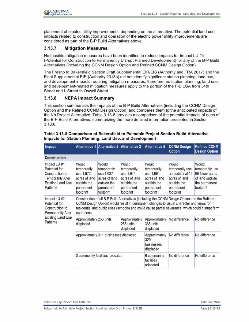
Section 3.13 Station Planning, Land Use, and Development
California High-Speed Rail Authority February 2020
Bakersfield to Palmdale Project Section Administrative Draft Project EIR/EIS Page | 3.13-39
placement of electric utility improvements, depending on the alternative. The potential land use impacts related to construction and operation of the electric power utility improvements are considered as part of the B-P Build Alternatives above.
3.13.7 Mitigation Measures No feasible mitigation measures have been identified to reduce impacts for Impact LU #4 (Potential for Construction to Permanently Disrupt Planned Development) for any of the B-P Build Alternatives (including the CCNM Design Option and Refined CCNM Design Option).
The Fresno to Bakersfield Section Draft Supplemental EIR/EIS (Authority and FRA 2017) and the Final Supplemental EIR (Authority 2018b) did not identify significant station planning, land use, and development impacts requiring mitigation measures; therefore, no station planning, land use, and development-related mitigation measures apply to the portion of the F-B LGA from 34th Street and L Street to Oswell Street.
3.13.8 NEPA Impact Summary This section summarizes the impacts of the B-P Build Alternatives (including the CCNM Design Option and the Refined CCNM Design Option) and compares them to the anticipated impacts of the No Project Alternative. Table 3.13-8 provides a comparison of the potential impacts of each of the B-P Build Alternatives, summarizing the more detailed information presented in Section 3.13.6.
Table 3.13-8 Comparison of Bakersfield to Palmdale Project Section Build Alternative Impacts for Station Planning, Land Use, and Development
Impact Alternative 1 Alternative 2 Alternative 3 Alternative 5 CCNM Design Option
Refined CCNM Design Option
Construction Impact LU #1: Potential for Construction to Temporarily Alter Existing Land Use Patterns
Would temporarily use 1,672 acres of land outside the permanent footprint
Would temporarily use 1,637 acres of land outside the permanent footprint
Would temporarily use 1,644 acres of land outside the permanent footprint
Would temporarily use 1,694 acres of land outside the permanent footprint
Would temporarily use an additional 15 acres of land outside the permanent footprint
Would temporarily use 66 fewer acres of land outside the permanent footprint
Impact LU #2: Potential for Construction to Permanently Alter Existing Land Use Patterns
Construction of all B-P Build Alternatives (including the CCNM Design Option and the Refined CCNM Design Option) would result in permanent changes to visual character and views for residential and public uses (schools) and could cause parcel severance, which could disrupt farm operations. Approximately 253 units displaced
Approximately255 units displaced
Approximately 368 units displaced
No difference No difference
Approximately 311 businesses displaced Approximately 329 businesses displaced
No difference No difference
3 community facilities relocated 6 community facilities relocated
No difference No difference
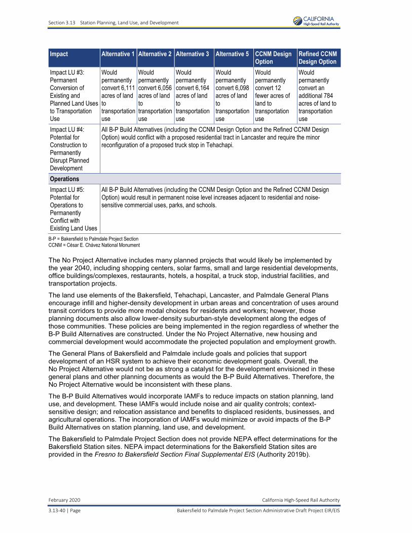
Section 3.13 Station Planning, Land Use, and Development
February 2020 California High-Speed Rail Authority
3.13-40 | Page Bakersfield to Palmdale Project Section Administrative Draft Project EIR/EIS
Impact Alternative 1 Alternative 2 Alternative 3 Alternative 5 CCNM Design Option
Refined CCNM Design Option
Impact LU #3: Permanent Conversion of Existing and Planned Land Uses to Transportation Use
Would permanently convert 6,111acres of land to transportationuse
Would permanently convert 6,056 acres of land to transportation use
Would permanently convert 6,164 acres of land to transportation use
Would permanently convert 6,098 acres of land to transportation use
Would permanently convert 12 fewer acres of land to transportation use
Would permanently convert an additional 784 acres of land to transportation use
Impact LU #4: Potential for Construction to Permanently Disrupt Planned Development
All B-P Build Alternatives (including the CCNM Design Option and the Refined CCNM Design Option) would conflict with a proposed residential tract in Lancaster and require the minor reconfiguration of a proposed truck stop in Tehachapi.
Operations Impact LU #5: Potential for Operations to Permanently Conflict with Existing Land Uses
All B-P Build Alternatives (including the CCNM Design Option and the Refined CCNM Design Option) would result in permanent noise level increases adjacent to residential and noise-sensitive commercial uses, parks, and schools.
B-P = Bakersfield to Palmdale Project Section CCNM = César E. Chávez National Monument
The No Project Alternative includes many planned projects that would likely be implemented by the year 2040, including shopping centers, solar farms, small and large residential developments, office buildings/complexes, restaurants, hotels, a hospital, a truck stop, industrial facilities, and transportation projects.
The land use elements of the Bakersfield, Tehachapi, Lancaster, and Palmdale General Plans encourage infill and higher-density development in urban areas and concentration of uses around transit corridors to provide more modal choices for residents and workers; however, those planning documents also allow lower-density suburban-style development along the edges of those communities. These policies are being implemented in the region regardless of whether the B-P Build Alternatives are constructed. Under the No Project Alternative, new housing and commercial development would accommodate the projected population and employment growth.
The General Plans of Bakersfield and Palmdale include goals and policies that support development of an HSR system to achieve their economic development goals. Overall, the No Project Alternative would not be as strong a catalyst for the development envisioned in these general plans and other planning documents as would the B-P Build Alternatives. Therefore, the No Project Alternative would be inconsistent with these plans.
The B-P Build Alternatives would incorporate IAMFs to reduce impacts on station planning, land use, and development. These IAMFs would include noise and air quality controls; context-sensitive design; and relocation assistance and benefits to displaced residents, businesses, and agricultural operations. The incorporation of IAMFs would minimize or avoid impacts of the B-P Build Alternatives on station planning, land use, and development.
The Bakersfield to Palmdale Project Section does not provide NEPA effect determinations for the Bakersfield Station sites. NEPA impact determinations for the Bakersfield Station sites are provided in the Fresno to Bakersfield Section Final Supplemental EIS (Authority 2019b).
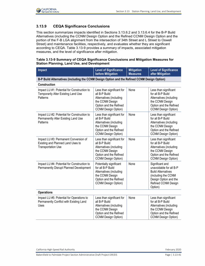
Section 3.13 Station Planning, Land Use, and Development
California High-Speed Rail Authority February 2020
Bakersfield to Palmdale Project Section Administrative Draft Project EIR/EIS Page | 3.13-41
3.13.9 CEQA Significance Conclusions This section summarizes impacts identified in Sections 3.13.6.2 and 3.13.6.4 for the B-P Build Alternatives (including the CCNM Design Option and the Refined CCNM Design Option and the portion of the F-B LGA alignment from the intersection of 34th Street and L Street to Oswell Street) and maintenance facilities, respectively, and evaluates whether they are significant according to CEQA. Table 3.13-9 provides a summary of impacts, associated mitigation measures, and the level of significance after mitigation.
Table 3.13-9 Summary of CEQA Significance Conclusions and Mitigation Measures for Station Planning, Land Use, and Development
Impact Level of Significance before Mitigation
Mitigation Measures
Level of Significance after Mitigation
B-P Build Alternatives (including the CCNM Design Option and the Refined CCNM Design Option) Construction Impact LU #1: Potential for Construction toTemporarily Alter Existing Land Use Patterns
Less than significant for all B-P Build Alternatives (including the CCNM Design Option and the Refined CCNM Design Option)
None Less than significant for all B-P Build Alternatives (including the CCNM Design Option and the Refined CCNM Design Option)
Impact LU #2: Potential for Construction to Permanently Alter Existing Land Use Patterns
Less than significant for all B-P Build Alternatives (including the CCNM Design Option and the Refined CCNM Design Option)
None Less than significant for all B-P Build Alternatives (including the CCNM Design Option and the Refined CCNM Design Option)
Impact LU #3: Permanent Conversion of Existing and Planned Land Uses to Transportation Use
Less than significant for all B-P Build Alternatives (including the CCNM Design Option and the Refined CCNM Design Option)
None Less than significant for all B-P Build Alternatives (including the CCNM Design Option and the Refined CCNM Design Option)
Impact LU #4: Potential for Construction to Permanently Disrupt Planned Development
Potentially significant for all B-P Build Alternatives (including the CCNM Design Option and the Refined CCNM Design Option)
None Significant and unavoidable for all B-P Build Alternatives (including the CCNM Design Option and the Refined CCNM Design Option)
Operations Impact LU #5: Potential for Operations to Permanently Conflict with Existing Land Uses
Less than significant for all B-P Build Alternatives (including the CCNM Design Option and the Refined CCNM Design Option)
None Less than significant for all B-P Build Alternatives (including the CCNM Design Option and the Refined CCNM Design Option)
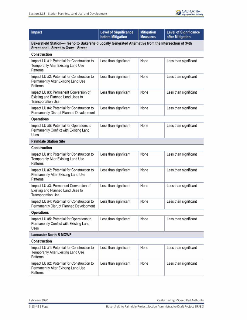
Section 3.13 Station Planning, Land Use, and Development
February 2020 California High-Speed Rail Authority
3.13-42 | Page Bakersfield to Palmdale Project Section Administrative Draft Project EIR/EIS
Impact Level of Significance before Mitigation
Mitigation Measures
Level of Significance after Mitigation
Bakersfield Station—Fresno to Bakersfield Locally Generated Alternative from the Intersection of 34th Street and L Street to Oswell Street Construction Impact LU #1: Potential for Construction to Temporarily Alter Existing Land Use Patterns
Less than significant None Less than significant
Impact LU #2: Potential for Construction to Permanently Alter Existing Land Use Patterns
Less than significant None Less than significant
Impact LU #3: Permanent Conversion of Existing and Planned Land Uses to Transportation Use
Less than significant None Less than significant
Impact LU #4: Potential for Construction to Permanently Disrupt Planned Development
Less than significant None Less than significant
Operations Impact LU #5: Potential for Operations to Permanently Conflict with Existing Land Uses
Less than significant None Less than significant
Palmdale Station Site Construction Impact LU #1: Potential for Construction to Temporarily Alter Existing Land Use Patterns
Less than significant None Less than significant
Impact LU #2: Potential for Construction to Permanently Alter Existing Land Use Patterns
Less than significant None Less than significant
Impact LU #3: Permanent Conversion of Existing and Planned Land Uses to Transportation Use
Less than significant None Less than significant
Impact LU #4: Potential for Construction to Permanently Disrupt Planned Development
Less than significant None Less than significant
Operations Impact LU #5: Potential for Operations to Permanently Conflict with Existing Land Uses
Less than significant None Less than significant
Lancaster North B MOWF Construction Impact LU #1: Potential for Construction to Temporarily Alter Existing Land Use Patterns
Less than significant None Less than significant
Impact LU #2: Potential for Construction to Permanently Alter Existing Land Use Patterns
Less than significant None Less than significant
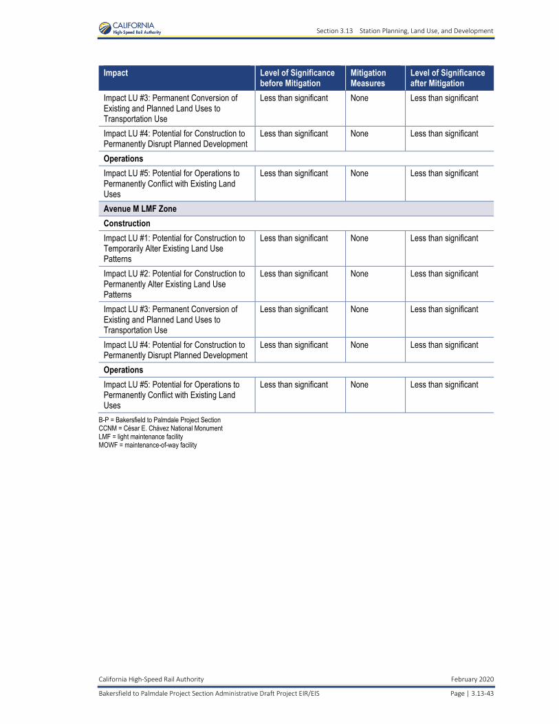
Section 3.13 Station Planning, Land Use, and Development
California High-Speed Rail Authority February 2020
Bakersfield to Palmdale Project Section Administrative Draft Project EIR/EIS Page | 3.13-43
Impact Level of Significance before Mitigation
Mitigation Measures
Level of Significance after Mitigation
Impact LU #3: Permanent Conversion of Existing and Planned Land Uses to Transportation Use
Less than significant None Less than significant
Impact LU #4: Potential for Construction to Permanently Disrupt Planned Development
Less than significant None Less than significant
Operations Impact LU #5: Potential for Operations to Permanently Conflict with Existing Land Uses
Less than significant None Less than significant
Avenue M LMF Zone Construction Impact LU #1: Potential for Construction to Temporarily Alter Existing Land Use Patterns
Less than significant None Less than significant
Impact LU #2: Potential for Construction to Permanently Alter Existing Land Use Patterns
Less than significant None Less than significant
Impact LU #3: Permanent Conversion of Existing and Planned Land Uses to Transportation Use
Less than significant None Less than significant
Impact LU #4: Potential for Construction to Permanently Disrupt Planned Development
Less than significant None Less than significant
Operations Impact LU #5: Potential for Operations to Permanently Conflict with Existing Land Uses
Less than significant None Less than significant
B-P = Bakersfield to Palmdale Project Section CCNM = César E. Chávez National Monument LMF = light maintenance facility MOWF = maintenance-of-way facility
Section 3.13 Station Planning, Land Use, and Development
This page intentionally left blank
February 2020 California High-Speed Rail Authority
3.13-44 | Page Bakersfield to Palmdale Project Section Administrative Draft Project EIR/EIS