Embed Size (px)
Citation preview

Section 404 / NEPA
Merger Process
Information
November 2, 2012

Memorandum of Understanding


Merger Screening Process

Rev. 10/6/04 Rev. 1/6/04
Rev. 3/18/05 Rev. 2/22/12 Rev. 7/16/12 Rev. 11/2/12
Merger Screening Process
The screening process is applicable for TIP Projects that will have an environmental document prepared by the Project Development and Environmental Analysis Unit.
General As stated in the MOU, the Section 404/NEPA Merger Process will generally apply to all new location projects and all projects that will likely require an individual permit under Section 404 of the Clean Water Act. FHWA, USACE, NCDENR, and NCDOT will consult early in the project development process and apply screening criteria to identify specific projects that will follow this process. Additional guidance is provided to assist in identifying specific projects that will follow this process. It is recognized that there are substantial benefits in carrying projects through the Merger Process. The Merger Process requires a high degree of commitment of resources by the many agencies that are involved in the process. Consultation between the USACE, FHWA, NCDENR, and NCDOT to determine applicability is necessary and important. The guidance listed below will be used to determine if projects should be moved through the Merger Process: Guidance for Applicability Determination The consultation between the FHWA, USACE, NCDOT, and NCDENR should generally be a meeting so that all data can be reviewed including aerial photography. Phone calls and e-mail may also be appropriate for certain level of impacts that do not require a detailed review of data. In reviewing the potential impacts of projects, it is important to consider the potential conflict of the important natural resources with project settings, intensity of impacts and important socio-economic (human) resources such as Environmental Justice Communities, Section 4(f) properties, and relocations. The need for detailed alternative analysis studies to avoid impacts to these important resources and evaluate the conflict between resources should determine the basis for applying the merger process to projects. The NCDOT Project Development Engineer will document the results of this consultation and provide copies to FHWA and USACE.

Rev. 10/6/04 Rev. 1/6/04
Rev. 3/18/05 Rev. 2/22/12 Rev. 7/16/12 Rev. 11/2/12
If the project team members for USACE, FHWA, NCDENR and NCDOT cannot reach agreement, the decision will be referred to the USACE’s NCDOT Coordinator, FHWA’s Operations Engineer, NCDENR Deputy Secretary or designee, and NCDOT’s Manager of the Project Development and Environmental Analysis Unit for resolution. Screening Considerations New location and widening projects: Question 1: Is a Section 404 Individual Permit likely?
• If a Section 404 IP is likely, FHWA, USACE, NCDENR, and NCDOT will discuss the full scope of the project and whether there is a need “for detailed alternative analysis studies to avoid impacts” to important resources and evaluate the conflict between resources. Please reference the Guidance for Applicability Determination above.
• If a project’s scope is in question or if it is unclear or undecided if the Merger Process will aid in the overall evaluation of the project, the team has two options: a. Place the project in the Merger Process with the understanding that it
may be removed if later project information supports the removal, or b. Elevate the decision as directed in the Guidance for Applicability
Determination above.
Question 2: Is a Section 404 regional or Nationwide permit likely and will the project potentially impact a Critical Water Supply Area or Total Direct Impacts > one acre of wetlands or > 500 feet of stream?
• If a Section 404 regional or Nationwide permit is likely and the project impacts one of the criteria above, the FHWA, USACE, NCDENR and NCDOT will consult as part of project scoping prior to scheduling the Concurrence Point No. 1 meeting to determine if the project should be placed in the Merger. Other resource agencies may be consulted for input as appropriate.
Bridge Projects Question 1: Is the project a replace in-place (in existing right-of-way) only bridge
project? • If the only alternative under consideration is replace in-place with off site
detour, then no merger should be needed. If not proceed

Rev. 10/6/04 Rev. 1/6/04
Rev. 3/18/05 Rev. 2/22/12 Rev. 7/16/12 Rev. 11/2/12
Question 2: Is an Individual Permit (IP) required from USACE?
• If an IP is required, or is likely to be required due to potential project impacts; then the NCDOT Rep. will consult with USACE, NCDENR, and FHWA to determine if merger is recommended.
Question 3: Does the project involve potential impacts to or involvement with
two or more of the following types of resources? Wetlands Buffer Rules Water Supply Critical Areas CAMA – Areas of Environmental Concern T&E species present Section 4(f)/Section 106 Environmental Justice Unusually high level of public controversy Unusually large number of relocations for project type Compelling reason[s] to maintain traffic onsite
If so, NCDOT will consult with USACE. NCDENR and FHWA to determine if merger is recommended.
Non-Merger Projects For projects that do not go through the merger process, it is important to note that NCDOT will still be fulfilling the avoidance and minimization requirements. Resource agencies will have the opportunity to review these projects through the normal NEPA and permitting process when the EA is circulated for comments or when the CE is signed. Additionally, for projects designated by the USACE, FHWA, NCDENR and NCDOT, NCDOT will hold a meeting with appropriate agencies to obtain their input on the adequacy of the avoidance and minimization measures achieved, prior to circulating the EA for comments or when the CE is signed. If information becomes available on a non-merger project that warrants it being considered for placement in the merger process, USACE, FHWA, NCDENR, and NCDOT will meet to determine if it should be placed in the merger and at what point based on the project status.

Rev. 10/6/04 Rev. 1/6/04
Rev. 3/18/05 Rev. 2/22/12 Rev. 7/16/12 Rev. 11/2/12
Projects in Merger As the project development advances and more detailed information becomes available, it may be possible to determine that a project in the Merger Process does not need to remain in merger. At each concurrence meeting, the Project Team should evaluate the need for the project to stay in the merger process. If these agencies agree, the project may be dropped from the merger process. The final decision to remove a project from the merger process rests with NCDOT, NCDENR, USACE, and FHWA. The project development engineer will document the results of the consultation and provide copies to all project team members.

1
Process I: Projects on
New Location

1
Rev. 10-20-04 Rev. 12-22-04 Rev. 3-18-05 Rev. 9-12-08 Rev. 7-16-12 Rev. 11-2-12
Process I - Projects on New Location
General
A process flow chart that outlines the Section 404/NEPA Merger Process (Merger Process) for projects on new location is attached (Process I). This flow chart depicts the major milestones in the process but it does not include all of the many activities that NCDOT must complete in the project development process. These other activities will be completed by NCDOT and input provided into the merger process at the appropriate time. For example, public involvement is a critical component of the project development activities and will be ongoing throughout the process. Information developed through public involvement will be made available to Project Team members for consideration in the decision making process. NOTE: This Section 404/NEPA Merger Process may be utilized as a 23 U.S.C. 139 Coordination Plan. Project Team Meetings
Team meetings will be held at each of the concurrence points in the Process. Additional meetings may be held as determined necessary by the Project Teams. NCDOT’s Project Development Engineer should coordinate closely with the appropriate USACE, FHWA, and NCDENR team members in scheduling any meetings and clearly defining the purpose of the upcoming meeting. The Project Development Engineer or Hydraulics Project Engineer will send the package of information for the meeting to team members so that they will have it in hand at least two weeks prior to the meeting. The transmittal to each team member should clearly state the purpose and objective of the meeting. This will allow team members time to review the information and be prepared to discuss any issues or concerns they have at the meeting. Appendix A provides guidance on information to be presented at each concurrence meeting.
At the end of each meeting, the Project Development Engineer or Hydraulics Project Engineer, with the team’s help, will summarize the results of the meeting, including agreements or concurrence points achieved. If agreement or concurrence is not obtained, the next steps or action items should be clearly identified. If additional information or action is required, the type of information

2
or action needed and the responsible agency(ies) or team member(s) should be clearly noted.
The Project Development Engineer is responsible for preparing a summary of all meetings for distribution to all team members, except the summary for the 4B and 4C Concurrence meetings that will be completed by the Hydraulics Project Engineer. Each team member will read the meeting summary that includes issues agreed upon, outstanding issues, and action statements (next steps) carefully to ensure accuracy of the project records. Substantive errors and omissions will be identified and provided within 30 days to the Project Development Engineer or Hydraulics Project Engineer for prompt resolution.
On-site project field reviews can be very beneficial in helping to understand a project’s purpose and need, human and natural environmental features and alternative analysis. Project Teams are encouraged to hold combined field reviews/meetings as needed to assist in the decision making process.
Step by Step Implementation Procedures
The following discussion is intended to provide more detailed guidance and explanation on the various steps and concurrence points in the attached flow chart. The numbered paragraphs correspond to steps or blocks in the chart.
1. Initiation of Project Study
For projects requiring Federal Environmental Impact Statements, NCDOT will send a project initiation letter to the FHWA -- North Carolina Division Administrator. The project initiation letter will contain the type of work, termini, length, and general location of the proposed project. This letter will also provide a list of any other Federal approvals (e.g., Section 404 permits) anticipated to be necessary and will indicate the timeframe within which the environmental review process should be started. NCDOT will begin the project study by gathering background data and information and sending out the project scoping letter and/or start of study letter. This letter initiates the project’s concept and solicits input from federal and state agencies (including the State Clearinghouse), local government agencies, the public, and other NCDOT units and branches. The level of detail provided in these letters includes a TIP description and a vicinity map.
2. Data Collection
The Project Development Engineer will collect all available information, including aerial photography (orthophotographs), and background data needed to hold a project scoping meeting, as identified by responses to the scoping letter and standard requirements.
3. Develop Project Team

3
The Project Development Engineer will consult with the appropriate USACE, NCDENR and FHWA representative to identify specific Project Team members. NCDOT will provide written verification of team members to all the team
members. If an agency declines to participate on the team, their decision will be documented in writing to NCDOT, NCDENR, USACE and FHWA. If an agency drops from the Project Team during the process, their self-removal will also be documented in writing.
For federally funded projects, the Lead Federal agency will be the Federal Highway Administration, and NCDOT will be a Joint Lead agency in accordance with 23 U.S.C. 139(c). If the project is state-funded, the Lead Federal Agency will usually be the U.S. Army Corps of Engineers, with NCDOT serving as a Joint Lead agency. The designation of the Lead Federal agency and any Joint Lead agencies will satisfy 23 U.S.C. 139(c) requirements (see Appendix). All Project Team members will be considered as Participating agencies in accordance with 23 U.S.C. 139(d).
The Merger Agreement serves as a standing invitation to all the Participating agencies named in the Merger Process Memorandum of Understanding (this includes Primary and Partnering signatories to the Memorandum of Agreement as well as other agencies when a project is within their respective geographic area) to participate in the environmental review process for individual projects, as appropriate based on jurisdiction. These agencies are: • U. S. Army Corps of Engineers • Federal Highway Administration • North Carolina Department of Transportation • U. S. Environmental Protection Agency • U. S. Fish and Wildlife Service • North Carolina DENR, Division of Water Quality • North Carolina Wildlife Resources Commission • North Carolina Department of Cultural Resources • North Carolina DENR, Division of Coastal Management (within the twenty
coastal counties) • Metropolitan Planning Organizations (MPO’s) (in MPO areas) • National Park Service (in the vicinity of national parklands) • U. S. Coast Guard (Coast Guard permitted bridges) • U. S. Forest Service (in the vicinity of national forest property) • Tennessee Valley Authority (within TVA region) • U. S. Fish and Wildlife Service – Refuge (in the vicinity of federal refuges) • Eastern Band of Cherokee Nation-Tribal Historic Preservation Officer • North Carolina Division of Marine Fisheries (when there is any possibility that
resources under their jurisdiction are in the project vicinity) • National Oceanic and Atmospheric Administration (NOAA) (when there is any
possibility that resources under their jurisdiction are in the project vicinity) • Rural Planning Organizations (RPOs)(in non-MPO areas)

4
Therefore, no 23 U.S.C. 139 invitation letter needs to be issued to agencies that are listed above. However, if the Joint Lead agencies (FHWA and NCDOT), after consulting with the other two Primary Signatory Agencies of the Merger Process ( USACE and NCDENR), agree to invite governmental agencies with an interest in the project other than those listed above, then a specific invitation to participate will be issued. The decision to invite an additional agency to participate will be based largely on that agency’s jurisdiction or authority with respect to the project, whether that agency has expertise or information relevant to the project, and whether that agency intends to submit comments on the project. The invitation shall set a deadline for responses to be submitted. The deadline may be extended by the Lead agencies for good cause. Any Federal agency that is invited by the Lead agencies to participate in the environmental review process for a project shall be designated as a Participating agency by the Lead agencies unless the invited agency informs the Lead agencies, in writing, by the deadline specified in the invitation that the invited agency - (A) has no jurisdiction or authority with respect to the project; (B) has no expertise or information relevant to the project; and (C) does not intend to submit comments on the project. The process for inviting Participating agencies satisfies 23 U.S.C. 139(d) requirements (see Appendix). A State, tribal, or local agency not listed as a primary or partnering agency above must respond affirmatively to the invitation to be designated as a Participating agency. If the State, tribal, or local agency fails to respond by the stated deadline or declines the invitation, regardless of the reasons for declining, the agency should not be considered a Participating agency. 4. Project Scoping
The Project Scoping Meeting is held by NCDOT to discuss background data, preliminary purpose and need, engineering and environmental inventories, the proposed scope of the project, and potential substantial project issues. The Project Team members will be invited to attend and provide input. For EIS projects, this may be the only opportunity for the Project Team members to review preliminary purpose and need information prior to presenting it to the public (see Step 6 below). Project Team members should attend the scoping meeting and provide written input in response to the scoping letter. Specifics regarding other potential opportunities for involvement will be made known to the Participating agencies prior to the scoping meeting. In lieu of a scoping meeting, a formal start of study meeting may be held on projects when the Project Development Engineer concludes that a formal meeting will expedite the project. This meeting will include all NCDOT Branches and Units responsible or participating in project development activities and local government representatives having an interest in the project. The Project Team members will be invited to attend and provide input. The purpose of this meeting is to share information regarding anticipated economic and transportation benefits and/or adverse impacts to the community, and known human and natural environmental constraints. The meeting will also

5
provide local government representatives an opportunity to provide input into the project scope. For federal EIS projects, the Lead agencies shall determine, in collaboration with Participating agencies at appropriate times during the study process, the methodologies to be used and the level of detail required in the analysis of each alternative for a project, in compliance with 23 U.S.C. 139(f)(4)(c) (see Appendix). This collaboration should begin during the scoping process. Decisions on methodologies and the level of detail will be documented and presented to the Project Team at appropriate times during the project development process. At the project scoping meeting, NCDOT will provide the proposed project schedule. The meeting attendees will present any issues that may impact the proposed schedule. Needed revisions to the project schedule will be identified and adjusted appropriately by NCDOT. Timeframes for review within the project schedule, and modification to the schedule will be consistent with requirements of 23 U.S.C. 139(g) (see Appendix). Also, the project schedule, and any modifications, will be made available to all Participating agencies and the public. 5. Notice of Intent
If NCDOT and FHWA determine an EIS should be prepared, a Notice of Intent will be filed in the Federal Register. If it is not clear at this point that potential project impacts warrant an EIS, the decision to prepare a Notice of Intent may be delayed until step 12 when more information is available. 6. Public Involvement
For projects for which a Federal Environmental Impact Statement (EIS) will be prepared, public involvement must occur prior to Concurrence Point 1 (Purpose and Need). One or more of the following public involvement techniques may be used at this point in the process:
• Citizens informational workshop • Website • Newsletter or other mailings • Press releases • Well-documented public involvement during the Comprehensive
Transportation Planning process1 Any of the employed techniques must present preliminary purpose and need information and solicit input on the need for and purpose of the project and potential preliminary study alternatives that might address the perceived need.
1 Upon full implementation of the Integration of Long Range Planning and Project Development and in accordance with 23 CFR 450.212, 318 and Appendix A, and 23 CFR 771.

6
If necessary, an informational Merger meeting can be scheduled to further discuss this information with the Project Team prior to the purpose and need public involvement. The decision to hold an informational Merger meeting should be made jointly between the Project Development Engineer, the USACE representative, and the FHWA Area Engineer, and NCDENR, and should be based on considerations such as the public involvement technique to be employed and the inter-agency participation and comments from the scoping meeting. Any public comment relevant to purpose and need will be considered by FHWA and NCDOT prior to Concurrence Point 1 and shared with the Project Team.
7. Develop Preliminary Purpose and Need (P & N)
Transportation Planning provides a Planning Level Purpose and Need for each project that was developed during the systems planning process to the Project Development Engineer. In cases where Transportation Planning does not have personnel assigned to a particular area, the Project Development Engineer will develop a draft Purpose and Need. Also, additional engineering and environmental inventory data may be obtained for use in further developing and refining the Purpose and Need for a project. The type of information and level of detail collected must be determined for each project and could include information such as the following:
♦ Preliminary limits of the study area ♦ Existing traffic and future no-build average daily traffic
♦ Roadway geometric deficiencies and accident history
♦ Transportation plans
♦ Land use plans
♦ Areas of interest to local citizens and elected officials
♦ Legislative mandates
♦ Economic initiatives
♦ Intermodal relationships, including bicycle/pedestrian systems, transit (rail and bus), port facilities and airport facilities
♦ Project history and background information including feasibility studies and community issues
♦ Highway Needs Inventory (HNI) status
♦ GIS Mapping

7
♦ Aerial Photography ♦ Other readily available information 8. Concurrence Point 1 - Purpose and Need and Stud y Area Defined The Purpose and Need (P & N) Statement forms the basis for identification of alternatives to be evaluated. Therefore, concurrence will be obtained on the Purpose and Need before potential alternatives are identified. NCDOT will prepare a Preliminary Purpose and Need Statement, along with supporting technical documentation. The P & N information package will be sent to team members so that they will receive it at least two weeks prior to the team meeting. The supporting technical information will include a GIS map of the study area and a summary of any information or comments from the public concerning purpose and need and community concerns. This statement should clearly demonstrate that a “need” exists and should define the “need” in terms understandable to the general public. The statement should clearly describe the problems that the proposed action is to correct.
A team meeting will be held to discuss the preliminary P & N Statement and Study Area along with supporting data. Team members will review the information prior to the meeting, including a summary of public input, and be prepared to discuss any concerns. At the meeting, the NCDOT Project Development Engineer will provide GIS level mapping of the Study Area and aerial photography (orthophotography). Also, any other readily available information will be presented for the team’s information. The Study Area may need to be expanded to accommodate environmental features. Also, it may be necessary to conduct more than one meeting on Purpose and Need if additional information is needed to define the Project Study Area. The goal of the meeting is for team members to concur with and sign the Purpose and Need and Study Area concurrence form.
NCDOT will provide the current schedule. Any changes made to the schedule since the last concurrence meeting will be presented along with the reasons for the change. The meeting attendees will present any issues that may impact the project schedule. Needed revisions to the project schedule will be identified and adjusted appropriately by NCDOT. If concerns are raised at the team meeting, which require additional documentation or revisions to the P & N Statement, the NCDOT will incorporate the additions or revisions and redistribute the P and N Statement for concurrence or comment. This will be done prior to the follow-up Concurrence Point 1 meeting or as soon as possible if it is determined that a second meeting is not required. 9. Environmental Features Map

8
After Purpose and Need and Study Area concurrence has been obtained, NCDOT, with consultation from the agencies, will develop an environmental features map illustrating resource areas of concern as well as topographic or photogrammetric mapping. The purpose of this mapping is to provide a means for identifying alternatives that warrant study on a screening level basis. Such features on the mapping will include but are not limited to:
♦ Infrastructure and topography ♦ Community features (i.e., boundaries, schools, churches, community centers,
hospitals, transit dependent populations, demographics, etc. ♦ Floodplains ♦ Historic properties and possible areas of archaeological concern ♦ Wetlands, streams, buffers, river basins, and water supply watersheds (GIS level information) ♦ Wildlife refuges and game lands ♦ Recreational areas and parks ♦ Hazardous material sites ♦ Existing land use map and locally adopted land use plan ♦ Threatened and Endangered Species information ♦ Significant Natural Heritage Program Areas ♦ Identify utilities within project study area using best available information Based on the environmental features map, the study area may be re-confirmed. Generally, the study area will not be redefined unless new information necessitates re-evaluation.
10. Alternative Corridors Development, Functional Desig n and Citizens Information Workshop (CIW)
For Federal EIS projects, the Lead agencies shall determine, in collaboration with Participating agencies at appropriate times during the study process (beginning in scoping), the methodologies to be used and the level of detail required in the analysis of each alternative for a project, in compliance with 23 U.S.C. 139(f)(4)(c) (see Appendix). The NCDOT Project Development Engineer and the Design Engineer will identify preliminary corridors that address the Purpose and Need for the project and consider the environmental constraints within the study area. The Design Engineers will prepare functional designs for each preliminary corridor that is considered. A functional design is a very general design that includes horizontal and vertical alignments, edge of pavements, slope stakes, and right of way limits for all alignments and interchanges. No turn lanes or superelevation are added at this stage. This design is done on orthophotographs.
8
After identification of the preliminary corridors, the NCDOT will hold a Citizens Informational Workshop (CIW) or conduct other public involvement to present the Project Purpose and Need for the project and preliminary corridors that are identified. Project Team members are encouraged to attend and participate in these workshops to fully understand public concerns and issues. A file memorandum will be prepared by the Project Development Engineer to summarize and document public input and it will be included as part of the

9
informational package for team members. The Project Team will consider the comments received at the CIW in selecting the range of alternatives to be studied further. Any additional corridors recommended by the public will be considered by NCDOT and presented to the Project Team as appropriate.
11. Alternative Development, Analysis, and Screening Meetings
Prior to the first Project Team meeting on alternatives, the Project Development Engineer will send team members a copy of a draft Preliminary Alternative Analysis Report, which includes the summary of public input. At the meeting on alternatives, team members should be prepared to discuss the alternatives and, if appropriate, suggest modifications to NCDOT’s preliminary conceptual alternatives and/or recommend additional alternatives. Also, team members may
♦ Identify specific or additional environmental resources that are important
♦ Recommend any additional alternatives/studies necessary
NCDOT will prepare detailed minutes of the meeting. It is recognized that one or more team meetings may be necessary to develop, analyze and screen alternatives to satisfy every agency’s needs. Team member comments will be noted in minutes of the meeting prepared by the Project Development Engineer.
Prior to the Project Team meeting for Concurrence Point 2 (Detailed Study Alternatives Carried Forward), the Preliminary Alternatives Report will be completed and distributed to the Project Team members. The report will identify all the alternatives considered during the preliminary alternatives phase of the project and provide justification for those alternatives recommended for elimination from further consideration. The decision to eliminate alternatives must be made jointly by the team members. No alternatives will be eliminated without the concurrence of each member of the Project Team. The rationale for eliminating alternatives from further consideration will be documented by the Project Development Engineer.
If no additional alternatives or studies are requested, the team may proceed directly to step 12 (Concurrence Point 2).
12. Concurrence Point 2 – Detailed Study Alternatives C arried Forward (DSA)
The intent of the Concurrence Point 2 meeting is to obtain consensus from the Project Team on which corridors will be fully evaluated as alternatives, including the “no build” alternative, in the environmental document. The alternatives selected must meet the purpose and need of the project with the exception of the “no build” alternative.
The Project Team will strive to reach agreement on alternatives that meet the Purpose and Need and include all alternatives that should be evaluated in detail in the environmental document to fulfill NEPA and Section 404 requirements. Concurrence by the Project Team on detailed study alternatives to be included in

10
the draft document, as part of the NEPA and NCEPA process and corresponding Section 404 Permit Public Notice, is not a commitment on the part of the regulatory agency to permit any of the alternatives nor is it a commitment for the engineers to seal any alternative. Rather, it is for the purpose of obtaining public and agency comments on the merits of each alternative for consideration by the decision-makers in the selection of the Least Environmentally Damaging Practicable Alternative (LEPDA)/Preferred Alternative.
At the Project Team meeting, the following topics will be discussed and documented in the meeting minutes:
♦ The rationale for retaining or dropping preliminary conceptual alternatives
♦ The level of involvement of other agencies and interested parties (i.e., Coast Guard, local agencies, Section 106 consulting parties, etc.), as well as their comments (if any) on the project
♦ Type of access control (may be discussed earlier in process if implicit in purpose and need)
The NCDOT will request formal concurrence at this meeting by asking team members to sign the Concurrence Point 2 form. The signatures indicate that the team member’s comments on the Preliminary Alternatives Report were adequately addressed and no new issues were raised during the meeting. If additional documentation or revisions to the report are necessary, the NCDOT will incorporate the additions or revisions and redistribute the report. If necessary, an additional team meeting will be scheduled to resolve outstanding concerns. Once concurrence is reached, no new alternatives will be added unless there is significant new information, or significant changes to the project, the environment, constructability, or laws and regulations.
NCDOT will provide the current schedule. Any changes made to the schedule since the last concurrence meeting will be presented along with the reasons for the change. The meeting attendees will present any issues that may impact the project schedule. Needed revisions to the project schedule will be identified and adjusted appropriately by NCDOT.
13. Environmental Analyses and Preliminary Design of Detailed Study
Alternatives
After the detailed study alternatives are selected, the potentially impacted human and natural resources, including wetland and stream delineations will be identified for each alternative. NCDCM’s GIS-based wetland inventory mapping program should be used to help identify wetland significance. The Project Development Engineer, in coordination with the Office of Natural Environment, will determine if there are resources that will require bridging decisions at Step 14, Concurrence Point 2A, and if so, will invite the Project Team members to attend an agency field review meeting. Also, if appropriate, an agency field review meeting will be held to:
11
♦ Verify jurisdictional wetland and stream boundaries. The USACE will provide
written jurisdictional verifications immediately after the field review meeting ♦ Review any potential mitigation sites that may be noted during the delineation
effort and coordinate with Ecosystem Enhancement Program (EEP) ♦ Review potential bridging decisions, if applicable After receipt of the delineations and necessary preliminary mapping, the Design Engineer will begin to develop the preliminary designs for each alternative. The preliminary design is a very specific design that includes horizontal and vertical alignments, edge of pavements, slope stakes, turn lanes, superelevation, and right of way revisions. This design is done on preliminary mapping. During the development of the design, care will be taken to avoid and minimize impacts to the natural and human environment based on information provided by the appropriate units in NCDOT. Where it is not practicable to avoid impacts, minimization measures will be employed using context sensitive design and other means to fit the project within the study area. The Design Engineer will coordinate the preliminary design for each detailed study alternative with the Utility Sections. The Utility Sections will identify areas where any known utilities are impacted. 14. Concurrence Point 2A – Bridging Decisions and Al ignment Review After the preliminary designs are complete, impacts based on project footprint will be identified and quantified. At this time, the preliminary designs will include any recommended control of access that will be acquired for the project. The control of access limits are needed so it can be reflected in right of way estimates, shown to the public and for the Project Team’s review. In addition, potential service road locations and potential utility impacts are identified so the impacts can be included in the comparison of the project alternatives. Using the hydraulic recommendations and all available environmental information, the Project Team will determine the placement and length of bridges. In addition, a review will be made to determine which natural resources warrant additional avoidance measures. The bridge locations and approximate lengths will be identified on each alternative. A concurrence meeting will be held to gain concurrence for all bridge locations and lengths. At this point, identification of any changes to the preliminary design that might be needed before finalization of the preliminary engineering and completion of the environmental document should be addressed. All team members will be asked to sign a concurrence form at the meeting to signify that they agree with the bridge locations and approximate lengths. After the bridge locations are determined, an updated construction cost estimate and summary of impacts for each alternative will be developed. This information will be provided

12
for each alternative within the Draft EIS or EA. In order to develop accurate cost estimates, where appropriate (such as habitat fragmentation), additional avoidance and minimization techniques that carry high monetary costs, such as wildlife crossings and retaining walls, will also be identified.
During the Concurrence Point 2A meeting, the Project Team will discuss which federal, state, and local environmental statutes and regulations may apply to each of the detailed study alternatives. Within NCDOT, the Office of the Natural Environment (ONE) is responsible for ensuring that the specific required steps are followed for each of the environmental permits, certifications, consultations, reviews and determinations that may be required throughout the project’s life. The Hydraulics Unit will ensure that FEMA flood insurance program regulations are followed where applicable.
NCDOT will provide the current schedule. Any changes made to the schedule since the last concurrence meeting will be presented along with the reasons for the change. The meeting attendees will present any issues that may impact the project schedule. Needed revisions to the project schedule will be identified and adjusted appropriately by NCDOT. Upon reaching this concurrence point, the Project Development Engineer will document all avoidance and minimization to all resources that has been achieved to this point in project development. This information will be provided to the Project Team and to ONE for inclusion in the updated permit application. Also, the Project Development Engineer will notify the Ecosystem Enhancement Program (EEP) of the worst-case preliminary design impacts. 15. Prepare Draft EIS/EA, Conceptual Mitigation Prop osal and Section 404
Application
The environmental document will be completed according to NEPA and an identification of impacts will be made for each of the alternatives that are studied in detail. There will be a discussion of why preliminary alternatives were eliminated.
NCDOT will address potential on-site compensatory mitigation options. For potential on-site mitigation sites, NCDOT ONE will prepare a feasibility study that includes an environmental evaluation that identifies historic resources, threatened and endangered species, parks, community issues, etc. NCDOT ONE may arrange an agency field meeting to review any potential on-site mitigation opportunities, discuss the environmental evaluation results, and determine which sites are acceptable to the agencies.
Pursuant to the Memorandum of Agreement among the NCDOT, NCDENR, and USACE signed July 22, 2002, the Ecosystem Enhancement Program (EEP) will provide all compensatory mitigation that is not satisfied by acceptable on-site mitigation. Preliminary determinations about the Federal, state, and local environmental statutes and regulations that may apply to each of the detailed study alternatives will be included within the environmental document. If the
13
project is within a CAMA county(ies), then potentially relevant CAMA land use plan policies that may apply to each detailed study alternative will also be included within the draft environmental document.
All information produced in previous studies will be incorporated in an environmental document.
The FHWA and NCDOT will review the preliminary environmental document for adequacy as it relates to NEPA requirements. NCDOT will revise the environmental document based on these comments or consult further with FHWA to resolve issues. The NEPA document, based on methodology decisions made at step 10 in this process, shall develop an analysis of secondary/indirect and cumulative impacts of sufficient scope and detail to fulfill all NEPA requirements. In addition, the analysis should be developed, in concurrence with current policies and procedures, to a level of detail sufficient to make decisions required by all other state and Federal laws, statutes, rules, and regulations. 16. Issue DEIS/EA and Submit Section 404 Application
NCDOT and FHWA will sign the title page of the environmental document (DEIS or EA) prior to NCDOT circulating it. NCDOT will submit the Section 404 permit application to the USACE at the time of document approval. NCDOT will also provide the USACE with a mailing list developed in the public involvement process that includes adjacent property owners and mailing labels. The environmental document will be distributed to federal agencies, State Clearinghouse, and local agencies and organizations for review and comment.
After issuance of the environmental document, an interagency field review will be made unless the Project Team determines otherwise. The purpose of this
meeting is for team members to review alternatives in the field prior to the Concurrence Point 3 meeting; however, it may not be necessary if team members have reviewed alternatives in the field previously. 17. Notice of Availability and Section 404 Public No tice
The USACE will issue a Section 404 Public Notice, if appropriate. The environmental document and Public Notice are made available for public and agency comment for the prescribed time frames. NCDOT should consult with the USACE, NCDOT board members, and other interested parties to set the public hearing date. Once the date is set, the USACE should be immediately notified of location, time and place. NCDOT will publicize the public hearing. 18. Corridor/Design Public Hearing
NCDOT will hold the Corridor/Design Public Hearing. Project Team members are encouraged to attend the public hearing to fully understand the public

14
concerns. The USACE and other Project Team members will be invited to attend the public hearing.
19. Agency and Public Comment Period
The public may submit written comments to NCDOT, FHWA and/or the USACE after, the public hearing. Also, agency and public comments on the environmental document should be submitted to FHWA and NCDOT, and the Section 404 Public Notice comments should be sent to the USACE. The agencies will format their letters to identify which comments are pertinent to the selection of the LEDPA/Preferred Alternative.
For projects requiring a Federal EIS, the commenting period for the Draft EIS will be a maximum of 60 days after publication in the Federal Register of notice of the date of availability, unless a different deadline is established by agreement of the lead agencies, the project sponsor, and all participating agencies, or the deadline is extended by FHWA and NCDOT for a good cause (23 U.S.C. 139(g)(2)(a)). For all other comment periods, the comment period will be no more than 30 days from availability of the materials on which the comment is requested, unless a different deadline is established by agreement of the lead agencies, the project sponsor, and all participating agencies, or the deadline is extended by FHWA and NCDOT for a good cause. NCDOT will adequately address those specific comments prior to selection of the Least Environmentally Damaging Practicable Alternative (LEDPA)/Preferred Alternative and distribute their responses within the information material for the Concurrence Point 3 meeting. 20. Post Hearing Meeting and Resolve Comments
Following the comment periods, NCDOT will review and summarize the comments received from the document review and public hearing process. The USACE will forward the comments on the Section 404 Public Notice for inclusion in the summary. NCDOT will then hold a post-hearing meeting. Project Team members are invited to attend this meeting. The purpose of this meeting is to evaluate all substantive comments received and determine if any additional studies or changes are needed to properly address issues that have been raised. Any additional work or studies to resolve comments will be completed by NCDOT. All agency comments on the environmental document and Section 404 Public Notice that affect the selection of the LEDPA/Preferred Alternative will be addressed and appropriate information or responses prepared prior to the Concurrence Point 3 meeting.
21. Concurrence Point 3 – LEDPA/Preferred Alternativ e Selection
A Project Team meeting will be held to determine the Least Environmentally Damaging Practicable Alternative (LEDPA) [Preferred Alternative under NEPA]. The Project Development Engineer will send the package of information for the
15
meeting to Project Team members so they will have it in hand at least two weeks prior to the meeting. The package will include a matrix (for example, summary information from DEIS) illustrating a comparison of impacts for the detailed study alternatives and a brief summary of previous Project Team decisions. The package will also include a summary of substantive comments received from agencies and the public and how these comments were addressed. When all substantive comments relative to the LEDPA/Preferred Alternative selection submitted by the agencies during the environmental document review and the public hearing/public notice commenting period have been adequately addressed and no new issues have been identified, the Project Team will select a LEDPA/Preferred Alternative. At the time it is selected, Project Team members will be reasonably certain that the LEDPA/Preferred Alternative will comply with all relevant regulations and permit requirements, is safe, and can be authorized. Project Team members in agreement with the LEDPA/Preferred Alternative will provide their formal concurrence at this meeting by signing the Concurrence Point 3 form. During the Concurrence Point 3 meeting, the Project Team will confirm the preliminary determination made during the Concurrence Point 2A meeting about the federal, state, and local environmental statutes and regulations that may apply to the LEDPA/Preferred Alternative. This confirmation is required due to changes that may have occurred in the project design and/or in the statutes and regulations since the preliminary determination was made during the Concurrence Point 2A meeting. Within NCDOT, the Office of the Natural Environment (ONE) is responsible for ensuring that the specific required steps are followed for each of the environmental permits, certifications, consultations, reviews and determinations that may be required throughout the project’s life. The Hydraulics Unit will ensure that FEMA flood insurance program regulations are followed where applicable. NCDOT will provide the current schedule. Any changes made to the schedule since the last concurrence meeting will be presented along with the reasons for the change. The meeting attendees will present any issues that may impact the project schedule. Needed revisions to the project schedule will be identified and adjusted appropriately by NCDOT. The public will be notified of the selection of the LEDPA/Preferred Alternative via newsletter, news release or other means determined satisfactory by NCDOT policy. 22. Concurrence Point 4 A – Avoidance and Minimization
Following selection of the LEDPA/Preferred Alternative, a Project Team meeting will be held to discuss additional avoidance and minimization efforts not included in the preliminary design during the alternative analysis phase of the project. This concurrence point should address issues such as alignment shifts, horizontal and vertical alignment, slopes, and construction techniques. In

16
addition, service road locations should be reviewed for avoidance and minimization and utility relocations should be reviewed for minimization.
For projects where bridge length and location were not previously agreed to, a decision on these parameters will be included in the Concurrence Point 4A meeting. Upon agreement that project jurisdictional impacts have been avoided and minimized to the maximum extent practicable based on current information and design available at that time, the Project Team members will sign the Concurrence Point 4A form. When avoiding and minimizing jurisdictional resource impacts, other resources will be considered.
It should be recognized that additional minimization may be achieved during the final design process with more precise mapping, including the project hydraulic design (Concurrence Points 4B and 4C). Upon reaching Concurrence Point 4A, the Project Development Engineer will document all avoidance and minimization that has been achieved to this point in project development. This information will be provided to the Project Team and to the Office of Natural Environment for inclusion in the updated Section 404 permit application.
NCDOT will provide the current schedule. Any changes made to the schedule since the last concurrence meeting will be presented along with the reasons for the change. The meeting attendees will present any issues that may impact the project schedule. Needed revisions to the project schedule will be identified and adjusted appropriately by NCDOT. 23. Prepare Final EIS or FONSI
NCDOT/FHWA will prepare the Final EIS or FONSI. The Final EIS or FONSI will discuss the rationale behind the selection of the LEDPA/Preferred Alternative. It is not necessary to complete Concurrence Point 4A prior to the completion of the Final EIS or FONSI. However, any additional avoidance and minimization measures that have been identified or incorporated up to that point in the project development should be included in the Final EIS or FONSI. The FHWA and NCDOT will review the final environmental document for adequacy as it relates to NEPA requirements. NCDOT will revise the environmental document based on these comments or consult further with the FHWA to resolve issues. The final environmental document will include all environmental commitments and the mitigation plan to address all resources, such as wetlands, streams, Section 106, Section 4(f), public access, etc. Preliminary determinations about the federal, state, and local environmental statutes and regulations that may apply to the LEDPA/Preferred Alternative will be included within the final environmental document. If the project is within a CAMA county(ies), then potentially relevant CAMA land use plan policies that may apply to the LEDPA/Preferred Alternative will also be included within the final environmental document. 24. Issue Final EIS or FONSI

17
NCDOT and FHWA will sign the title page of the final environmental document (FEIS or FONSI) prior to distribution by NCDOT. If FHWA expects to issue a FONSI for a highway project of four or more lanes on new location or a new controlled access freeway, copies of the EA shall be made available for public review for a minimum of 30 days before FHWA makes its final decision. NCDOT’s Citizens Participation Unit will announce this public availability by a notice similar to a public hearing notice. The environmental document will be distributed to federal agencies, State Clearinghouse, and local agencies and organizations for review and comment.
25. Agency and Public Comment Period
The agencies and the public may submit written comments to NCDOT and FHWA concerning the FEIS or FONSI document. In consultation with FHWA, NCDOT will respond directly to the commenting agencies concerning comments received on a FONSI. Comments received on a FEIS will be addressed in the ROD with copies provided to the commenting agency. The deadline for comment shall be a period of no more than 30 days from availability of the materials on which the comment is requested, unless a different deadline is established by agreement of the lead agencies, the project sponsor, and all participating agencies; or the deadline is extended by the lead agencies for a good cause. 26. Prepare and Issue Record of Decision (ROD)(EIS Pr ojects )
FHWA will issue the ROD. The ROD will address any comments received on the FEIS. A Notice of availability will be issued by NCDOT. 27. Design Public Hearing or Public Information Meeting A corridor/design public hearing was held after the Draft Environmental Impact Statement (Draft EIS) or the Environmental Assessment (EA) was completed. Because there was not a selected alternative presented to the public during the corridor/design public hearing, another hearing or citizens’ informational workshop will be held to display the selected alternative and to review any changes that were made within the design during the remainder of the NEPA process. This meeting should be held prior to the project being sent to right of way. Comments from the public will be reviewed to determine any needed changes. Changes requested from the public and accepted by the Project Team, if necessary, will be incorporated into the design prior to completion of right of way plans. (For phased projects please refer to text at the en d of this document.) 28. Develop Right of Way Plans for the Project After selection of the LEDPA/Preferred Alternative, the Location and Surveys Unit and the Photogrammetry Unit perform the final surveys and deliver the plan

18
sheet mapping needed for the development of the right of way and final plans. Upon receiving the plan sheets, the design engineers begin to develop the right of way plans for the project. After the design engineers complete the horizontal and vertical alignment for the roadway, the Utility Sections will review the horizontal and vertical alignment and will coordinate with the Hydraulics Unit regarding the utility locations. The Hydraulics Unit begins the development of the proposed drainage design and the Geotechnical Engineering Unit begins the detailed geotechnical investigations for the project. (The Design Engineers will develop the right of way plans following the alignment that was agreed upon at Concurrence Point 4A). 29. Concurrence Point 4B – 30 Percent Hydraulic Revi ew At the time the hydraulic design for the project is 30 percent complete, the Hydraulics Project Engineer will hold a Concurrence Point 4B meeting to review the development of the drainage design. All appropriate Project Team members should attend (USACE and NCDWQ attendance is mandatory. If the project is within a CAMA county(ies), NCDCM attendance is mandatory.) If a project requires a State Stormwater Management Permit, the Hydraulics Project Engineer will work with the NCDWQ Stormwater Management Section to obtain the permit and report its progress to the team members. The Hydraulics Project Engineer will provide the package of information to team members so that they receive it two weeks in advance of the meeting. Also, before the Concurrence Point 4B meeting is held, the Hydraulics Project Engineer will consult with the ONE staff to ensure that the environmental surveys (wetlands, threatened and endangered species, streams, and buffer) for each project is complete and current. At the 4B meeting, the Hydraulics Project engineer will present preliminary drainage designs to the team members. The drainage plans will depict the boundaries of the affected environmental areas (wetlands, perennial and intermittent streams, buffers, Coastal Area Management Act Areas of Environmental Concern (CAMA AEC’s), etc.), existing draining structures, layout of proposed drainage structures, and stormwater best management devices. Large structures such as bridges and box culverts will also be discussed. The Hydraulics Unit will take notes of comments received during the meeting. The Hydraulics Unit will distribute meeting minutes, which will include how comments will be addressed. Also, the meeting minutes will identify onsite mitigation opportunities that will be incorporated into the project design as appropriate.
It is understood minor vertical changes may be needed due to hydraulic needs. If vertical changes do occur that result in additional environmental impacts, minor horizontal adjustments in alignment may be appropriate.
NCDOT will provide the current schedule. Any changes made to the schedule since the last concurrence meeting will be presented along with the reasons for

19
the change. The meeting attendees will present any issues that may impact the project schedule. Needed revisions to the project schedule will be identified and adjusted appropriately by NCDOT.
30. Complete Right of Way Plans for the Project
Upon receiving the completed hydraulic design for the project, NCDOT Design Engineers incorporate the hydraulic design, locate any remaining service road locations, and establish the proposed right of way limits for the project. The Structure Design Engineers begin to develop the designs for bridges and culverts. The Utility Sections will begin to coordinate the determination of the utility conflicts and the development of the utility relocation preliminary designs with the Utility owners and the Design Engineers. The project is then reviewed with construction and right of way personnel to note any additional changes that may be required. The right of way plans are completed and sent to the Right of Way Branch to begin purchase of land required for the project. 31. NCDCM On-Site Pre-Application Meeting
For projects within a CAMA County(ies) that require a CAMA major permit, the NCDOT Office of Natural Environment Permit Specialist will request an on-site pre-application meeting with the appropriate NCDCM Field Representative. The purpose of this meeting is to review the plans and/or permit drawings and information that will be submitted with the CAMA permit application. This will ensure that when the CAMA major permit application is formally submitted, it contains all of the information necessary for processing. The purpose of this meeting is not to make changes to the project design, construction methodology or construction timeframe. However, if any potential changes to the project are identified at the on-site pre-application meeting, then they will be discussed with the full Project Team at the Concurrence Point 4C meeting prior to approval.
32. Concurrence Point 4C – Permit Drawings Review
At the time the hydraulic design is 100 percent complete and the permit drawings for the project are finalized, the Hydraulics Unit will hold a Concurrence Point 4C meeting. At the Concurrence Point 4C meeting, the Hydraulics Project Engineer will present copies of the Stormwater Management Plan to the Project Team members. A Stormwater Management Plan is a narrative, project-specific, Stormwater Design Report. It outlines project involvement, river basins, classifications of the involved water bodies, selected structural and non-structural best management practices, best management practice devices, and major structures (bridges and box culverts). The final permit drawings for the permit application will also be reviewed and revised based on comments received at this meeting.
Any area where utility relocations affect additional environmental resources beyond the footprint of the roadway will be shown on the permit drawings and will be included in the impacts presented in the application.

20
In addition, if the project is within a CAMA county(ies) and a CAMA Major permit is required, then all utility relocations that are not included in the permit drawings will be described within the CAMA Major Permit application either in narrative form or in a separate spreadsheet. The level of detail of utility relocation information required within the CAMA major permit application will be determined on a project-by-project basis at the NCDCM on-site pre-application meeting.
The Hydraulics Engineer will record minutes of the meeting and will address the team’s comments. Changes will be made based on the team’s comments. The changes will be made in the permit drawings before the permit application is sent.
The NCDOT Permit Specialist will contact the agencies via e-mail, letter, phone call or scheduling a meeting as appropriate to facilitate review of these changes. NCDOT will provide the current schedule. Any changes made to the schedule since the last concurrence meeting will be presented along with the reasons for the change. The meeting attendees will present any issues that may impact the project schedule. Needed revisions to the project schedule will be identified and adjusted appropriately by NCDOT.
33. Compensatory mitigation requirements
Compensatory mitigation requirements will be identified based on final project impacts.
In those events where on-site mitigation opportunities are available and determined acceptable and/or necessary by the Project Team, the mitigation plan and design will be developed in concert with the overall project design. Removal of existing causeway fills is strongly encouraged to offset project impacts and/or create mitigation credits for future project impacts. The on-site mitigation will be developed and implemented by NCDOT in collaboration with the Project Team and EEP. Under no circumstances will the project be permitted until such time that the detailed on-site mitigation plan is complete and approved by the permitting agencies. Pursuant to the Memorandum of Agreement among the NCDOT, NCDENR, and USACE, signed July 22, 2002, the Ecosystem Enhancement Program (EEP) will provide all compensatory mitigation that is not satisfied by acceptable on-site mitigation.
34. Submit Updated Permit Application
The Office of Natural Environment Permit Specialist submits updated permit application(s) as appropriate to all of the agencies for which permits are required. Permit application(s) will be submitted within approximately two months after the 4C meeting. The permit application package will vary according to each agency's specific requirements.
35. Permit Application Review and Processing

21
Upon receiving the permit application from NCDOT, the permitting agency(ies) will review the application for completeness. If the permit application is determined to be incomplete, the permitting agency(ies) will return the application to NCDOT for additional information, and/or inform NCDOT of the additional information that is required.
After the permitting agency(ies) determine that the permit application is complete, the permitting agency(ies) will assemble and distribute the application package for comment to any designated review agencies. This process varies according to the permit being requested.
If the permit application is found to be incomplete or inaccurate after processing has begun, or if additional information from NCDOT is necessary to adequately assess the project, the permitting agency(ies) that have permit processing deadlines may place an application on hold. NCDOT may also request in writing that its permit application be placed on hold at any time. If the permit application is placed on hold by the permitting agency(ies), the processing shall be resumed upon receipt of the necessary changes or necessary information from NCDOT. If NCDOT requested that the permit application be placed on hold, the processing shall be resumed upon receipt of a written request from NCDOT to resume processing.
During the permit application review and processing period, additional discussions and/or meetings may be conducted between NCDOT and the environmental agency(ies) to resolve any outstanding issues. The goal of the Merger Process, however, is to resolve all of these issues before the permit application is submitted to prevent delays in the construction letting.
36. Agency Public Notice if Required
If required by law or otherwise determined to be appropriate, the permitting agency(ies) will issue a Public Notice requesting comments from the public on the permit application. For example, the USACE is required to issue a Public Notice for any project that requires an Individual Permit. The USACE Public Notice is normally issued for a 30-day review and comment period. In such a case, the Public Notice would have been issued after the Draft EIS or EA and prior to Concurrence Point 3.
However, if, in the opinion of the USACE, an additional Public Notice is warranted due to changes in the project or new information, a second Public Notice will be issued. NCDCM is required to issue a 30-day Public Notice after a permit application is accepted as complete for any project that requires a CAMA Major Permit. NCDWQ generally is not required to issue a separate Public Notice.
37. Permit Decision
After the relevant permitting agency(ies) have reviewed the permit application(s) for compliance, and comments have been received and properly considered from the public, as well as relevant state and federal review agencies, a permit

22
decision will be made. The permit decision may be in the form of an approval, approval with conditions or denial. If a permit is issued, it will typically list specific conditions or restrictions on the development. The project must be constructed according to the permit conditions. A permit decision may be in the form of a denial if the outstanding issues have not been resolved satisfactorily. A permit denial is very unlikely for projects that follow the Merger Process provided that the full Project Team has reached concurrence at each concurrence point.
After a permit decision is made by a state permitting agency, then the state agency decision can be appealed by NCDOT or by a third party. If this occurs, then the state permitting agency(ies) will respond according to their specific requirements.
38. Changes to the Project’s Design, Construction Metho dology or Construction Timeframe
If changes to the project’s design, construction methodology or construction timeframe are needed at any time, additional coordination with the relevant environmental agency(ies) will be required. This includes the agencies that have permit authority over the project, as well as any other agencies that implement federal, state and local environmental statutes and regulations that apply to the project. If changes occur after the permit decisions are made, these changes may require the submittal of a request for a modification, amendment, Letter of Refinement or renewal to the relevant permit(s). A primary goal of the Merger Process is to greatly reduce, and eliminate if possible, the number of changes that may require additional coordination with the environmental agency (ies) after the original permits are issued. Permit modifications, in particular, are very time-consuming and problematic for all concerned parties due to the relatively short timeframe required for resolution.
It is the responsibility of NCDOT to conduct any additional coordination that may be required with the relevant environmental agency(ies). Coordination with the relevant environmental agencies, including the submittal of any required permit modification requests, should occur at least 2-3 months before the work in question must be conducted to allow adequate time for processing.
When reviewing the request, the relevant environmental agency(ies) may request additional information before making a decision. The decision may be in the form of an approval, approval with conditions or denial.
39. Final Plans for the Project
During the course of the right of way acquisition, the design engineers will begin to develop the final plans for the project. The final design is a very detailed design that also includes computing and summarizing contract quantities required for the project, incorporating right of way revisions, compiling plans from various units (Traffic Engineering Branch, Roadside Environmental Unit, Utilities Section, etc.) and incorporating them in the project. After receiving all necessary permits, NCDOT will make sure that all environmental commitments and permit conditions are incorporated. NCDOT will ensure that construction drawings

23
match the permit plan drawings and permit conditions, including any permit modifications.
40. Let Project
The project is advertised so that all interested contractors can bid on the project. The bids are opened on the project letting date. After receiving bids, the project is considered for award by the NCDOT Board of Transportation. The Board then usually awards the contract to the low bidder and construction will usually start approximately 45 days after the contract is awarded. The contractor will be bound to the permit conditions and any environmental commitments that were developed during the NEPA and/or NCEPA environmental documentation.
41. Preconstruction Meeting
After the contract is awarded, and prior to the initiation of construction, NCDOT and the Contractor will hold a preconstruction meeting. NCDOT will provide all Project Team members with a copy of the final plans at least 2 weeks prior to the preconstruction meeting along with a description of any changes that have been made to the project’s design, construction methodology or construction timeframe. The purpose of this meeting is to review the final plans and the contents of the bid package, including any permit conditions and environmental commitments. The preconstruction meeting will be scheduled for a time when the USACE, NCDWQ and NCDCM (if a CAMA major permit was issued) can attend. All of the Project Team members will be invited to the preconstruction meeting with a minimum of thirty (30) days notice.
42. Compliance monitoring
The NCDOT Division Engineer will ensure that all permits, permit conditions and associated documents are readily available on site at all times. The Division Engineer is responsible for ensuring that all federal, state, and local environmental statutes and regulations are adhered to after the project is let, including any permit conditions, and environmental commitments.
The Division Environmental Officer will provide assistance to the Division Engineer in meeting these requirements. Representatives from USACE, NCDCM, NCDWQ and other environmental agencies may visit the project site, including any disposal or borrow areas, at any time to conduct compliance inspections.
43. Project Completion
All work, including compliance with environmental conditions, must be completed prior to the expiration date of the permits. If necessary, a permit renewal may be requested. The decision to renew a permit may be in the form of an approval, approval with conditions or denial depending upon the relevant agency(ies) specific requirements. Renewal (extension) of permits must occur before the permits expire.
24
Upon completion of all work approved within the 401 Water Quality Certification or applicable Buffer Rules, and any subsequent modifications, NCDOT will return the Certificate of Completion to the NCDWQ 401/Wetlands Unit after obtaining the Division Engineer’s signature. Upon completion of all work, the Division Engineer and Division Environmental Officer will sign and return the USACE compliance form to the USACE. Permitting Process for Phased New Location Projects Many project corridor lengths are broken into a number of project segments and are funded at different timeframes for right of way acquisition and construction. Therefore, right of way plan preparation and final plan preparation occur at various timeframes depending upon the project segment’s schedule. For a project that has multiple project segments, the following process will occur: the NEPA document will be written for the entire project corridor length (Steps 1-27). At the time of the Draft EIS or EA issuance, the NCDOT will submit a Section 404 application for the entire project corridor. The application will also include the plan for how compensatory mitigation will be addressed for the entire project (Step 33). An approved compensatory mitigation plan must be provided for the entire project before any project segment is permitted. Following the submittal of the application, the steps in the process that extend to the issuance of the FONSI or ROD (whichever is applicable) and the public information meeting will be completed for the entire project corridor length and Concurrence Point 4A will be achieved for the entire project corridor length. The development of right of way plans on through to the project letting and construction (Steps 28-43) will begin for the project segment(s) that are imminently scheduled for right of way acquisition and letting. At the time the right of way plans are completed, an updated permit application will be submitted that will include right of way plans for the projects segment(s) that are imminently scheduled for right of way acquisition and letting. Preliminary designs will be submitted with the permit application for the remaining project segments that are scheduled for later years. The permitting agencies will then take final action on the permit application for all project segments. Any permits that are issued will have conditions that a final design will have to be submitted and written approval and/or permit modification obtained from the USACE and NCDENR before construction can begin on those project segments where only preliminary design was submitted with the application. As the right of way and letting date draws near for the remaining project segment(s), the development of right of way plans and the completion of steps that lead to the project letting and construction (Steps 28-43) will be completed for each project segment(s). At the time the right of way plans for the remaining project segment(s) are completed, a request for a permit modification will be submitted for those project segment(s). This request will contain the final design information for the project segment(s). Prior to providing written approval and/or permit modification, the USACE and NCDENR, in coordination with the Project

25
Team, will ensure that all appropriate avoidance and minimization measures have been incorporated in the project design. NCDOT will be notified of the decision on the requested segment(s) approval.

Process II: Widening and Other
Improvement Projects

1
Rev: 10-20-04 Rev: 12-23-04
Rev: 3-14-05 Rev: 9-12-08
Rev: 7-16-12
Process II – Widening and Other Improvement Project s
General A process flow chart that outlines the Section 404/NEPA Merger Process (Merger Process) for projects on new location is attached (Process I). This flow chart depicts the major milestones in the process but it does not include all of the many activities that NCDOT must complete in the project development process. These other activities will be completed by NCDOT and input provided into the merger process at the appropriate time. For example, public involvement is a critical component of the project development activities and will be ongoing throughout the process. Information developed through public involvement will be made available to Project Team members for consideration in the decision making process. NOTE: This Section 404/NEPA Merger Process may be utilized as a 23 U.S.C. 139 Coordination Plan. Project Team Meetings Team meetings will be held at each of the concurrence points in the Process. The Project Teams may hold additional meetings as determined necessary. NCDOT’s Project Development Engineer should coordinate closely with the appropriate USACE, FHWA, and NCDENR team members in scheduling any meetings and clearly defining the purpose of the upcoming meeting. The Project Development Engineer or Hydraulics Project Engineer will send the package of information for the meeting to team members so that they will have it in hand at least two weeks prior to the meeting. The transmittal to each team member should clearly state the purpose and objective of the meeting. This will allow team members time to review the information and be prepared to discuss any issues or concerns they have at the meeting. Appendix A provides guidance on information to be presented at each concurrence meeting. At the end of each meeting, the Project Development Engineer or Hydraulics Project Engineer, with the team’s help, should summarize the results of the meeting, including agreements or concurrence points achieved. If agreement or concurrence is not obtained the next steps or action should be clearly identified. If additional information or action is required, the type of information or action needed and the responsible agency(s) or team member(s) should be clearly noted.

2
The Project Development Engineer is responsible for preparing a summary of all meetings for distribution to all team members, except the summary for the 4B and 4C Concurrence Meetings, which will be completed by the Hydraulics Project Engineer. Each team member will read the meeting summary that includes issues agreed upon, outstanding issues, and action statements (next steps) carefully to ensure accuracy of the project records. Substantive errors and omissions will be identified and provided within 30 days to the Project Development Engineer or Hydraulics Project Engineer for prompt resolution.
On-site project field reviews can be very beneficial in helping to understand a project’s purpose and need, human and natural environmental features and alternative analysis. Project Teams are encouraged to hold combined field reviews/meetings as needed to assist in the decision making process. Step-by-Step Implementation Procedures The following discussion is intended to provide more detailed guidance and explanation on the various steps and concurrence points in the attached flow chart. The numbered paragraphs correspond to steps or blocks in the chart.
1. Initiation of Project Study For projects requiring Federal Environmental Impact Statements, NCDOT will send a project initiation letter to the FHWA -- North Carolina Division Administrator. The project initiation letter will contain the type of work, termini, length, and general location of the proposed project. This letter will also provide a list of any other Federal approvals (e.g., Section 404 permits) anticipated to be necessary and will indicate the timeframe within which the environmental review process should be started. NCDOT will begin the project study by gathering background data and information and sending out the project scoping letter and/or start of study letter. This letter initiates the project’s concept and solicits input from federal and state agencies (including the State Clearinghouse), local government agencies, the public, and other NCDOT units and branches. The level of detail provided in these letters includes a TIP description and a vicinity map. 2. Data Collection The Project Development Engineer will collect all available information, including aerial photography (digital mosaic), and background data, needed to hold the project scoping meeting, as identified by responses to the scoping letter and standard requirements. 3. Environmental Features Map NCDOT - with consultation from the agencies - will develop an environmental features map illustrating resource areas of concern as well as topographic or photogrammetric mapping. The purpose of this mapping is to provide a means for identifying alternatives that warrant study on a screening level basis. This

3
mapping could also be used by the team to gauge the applicability of the Merger Process. Such features on the mapping will include but are not limited to: ♦ Infrastructure and topography ♦ Community features (i.e., boundaries, schools, churches, community centers,
hospitals, transit dependent populations, demographics, etc.) ♦ Floodplains ♦ Historic properties and possible areas of archaeological concern ♦ Wetlands, streams, buffers, river basins, and water supply watersheds (GIS level information) ♦ Wildlife refuges and game lands ♦ Recreational areas and parks ♦ Hazardous material sites ♦ Existing land use map and locally adopted land use plan ♦ Threatened and Endangered Species information ♦ Significant Natural Heritage Program Areas ♦ Utilities within project study area using best available information Based on the environmental features map, the study area may be re-confirmed. Generally, the study area will not be redefined unless new information necessitates re-evaluation.
4. Develop Preliminary Purpose and Need Transportation Planning provides a Planning Level Purpose and Need for each project that was developed during the system planning process to the Project Development Engineer. In cases where Transportation Planning does not have personnel assigned to a particular area, the Project Development Engineer will develop the Purpose and Need (P & N). Also, additional engineering and environmental inventory data may be obtained for use in further developing and refining the purpose and need for a project. The type of information and level of detail collected must be determined for each project and could include information such as the following: ♦ Preliminary limits of the study area ♦ Existing traffic and future no-build average daily traffic ♦ Roadway geometric deficiencies and accident history ♦ Transportation plans ♦ Land use plans ♦ Areas of interest to local citizens and elected officials ♦ Legislative mandates ♦ Economic initiatives ♦ Intermodal relationships, including bicycle/pedestrian systems, transit (rail
and bus), port facilities and airport facilities ♦ Project history and background information including feasibility studies
and community issues ♦ Highway Needs Inventory (HNI) status ♦ MPO’s Metropolitan transportation Plan (MTP)

4
♦ Major Investment Study (MIS) status/information ♦ GIS Mapping ♦ Aerial Photography ♦ Available Mapping with Delineated Jurisdictional Areas ♦ Traffic Study and Capacity Analysis 5. Develop Project Team The Project Development Engineer will consult with the appropriate USACE, NCDENR and FHWA representative to identify specific Project Team members. NCDOT will provide written verification of team members to all the team members. If an agency declines to participate on the team, their decision will be documented in writing to NCDOT, NCDENR, USACE, and FHWA. If an agency drops from the Project Team during the process, their self-removal will also be documented in writing. The NCDOT will provide writeen verification of team members to all the team members prior to Step 10 (Concurrence Point 1). For federally funded projects, the Lead Federal agency will be the Federal Highway Administration, and NCDOT will be a Joint Lead agency in accordance with 23 U.S.C.139(c). If the project is state funded, the Lead Federal Agency will usually be the U. S. Army Corps of Engineers, with NCDOT serving as a Joint Lead agency. The designation of the Lead Federal agency and any Joint Lead agencies will satisfy 23 U.S.C. 139 (c) requirements (see Appendix). All Project Team members will be considered as Participating agencies in accordance with 23 U.S.C.139(d). In the case of projects requiring an EIS, the Merger Agreement serves as a standing invitation to all the Participating agencies named in the Merger Process Information (this includes Primary and Partnering signatories to the Memorandum of Agreement as well as other agencies when a project is within their respective geographic area) to participate in the environmental review process for individual projects, as appropriate based on jurisdiction. These agencies are: • U. S. Army Corps of Engineers • Federal Highway Administration • North Carolina Department of Transportation • U. S. Environmental Protection Agency • U. S. Fish and Wildlife Service • North Carolina DENR, Division of Water Quality • North Carolina Wildlife Resources Commission • North Carolina Department of Cultural Resources • North Carolina DENR, Division of Coastal Management (within the twenty
coastal counties) • Metropolitan Planning Organizations (MPO’s) (in MPO areas) • National Park Service (in the vicinity of national parklands)

5
• U. S. Coast Guard (Coast Guard permitted bridges) • U. S. Forest Service (in the vicinity of national forest property) • Tennessee Valley Authority (within TVA region) • U. S. Fish and Wildlife Service – Refuge (in the vicinity of federal refuges) • Eastern Band of Cherokee Nation-Tribal Historic Preservation Officer • North Carolina Division of Marine Fisheries and National Oceanic and
Atmospheric Administration (NOAA) (when there is any possibility that resources under their jurisdiction are in the project vicinity)
• Rural Planning Organizations (RPOs)(in non-MPO areas) Therefore, no 23 U.S.C. 139 invitation letter needs to be issued to agencies that are listed above. However, if the Joint Lead agencies, FHWA and NCDOT, after consulting with the other two Primary Signatory Agencies of the Merger Process (USACE and NCDENR) agree to invite governmental agencies with an interest in the project other than those listed above, then a specific invitation to participate will be issued The decision to invite an additional agency to participate will be based largely on that agency’s jurisdiction or authority with respect to the project, whether that agency has expertise or information relevant to the project, and whether that agency intends to submit comments on the project. The invitation shall set a deadline for responses to be submitted. The deadline may be extended by the Lead agencies for good cause. Any Federal agency that is invited by the Lead agencies to participate in the environmental review process for a project shall be designated as a Participating agency by the Lead agencies unless the invited agency informs the Lead agencies, in writing, by the deadline specified in the invitation that the invited agency - (A) has no jurisdiction or authority with respect to the project; (B) has no expertise or information relevant to the project; and (C) does not intend to submit comments on the project. The process for inviting Participating agencies satisfies 23 U.S.C. 139(d) requirements (see Appendix).
NCDOT will provide written verification of team members to all the team members prior to Step 9 (Concurrence Point 1). If an agency declines to participate on the team, its decision will be documented in writing to NCDOT, NCDENR, USACE and FHWA. If an agency drops from the Project Team during the process, its self-removal will also be documented in writing. For projects requiring an EIS, “Participating agencies” as defined by Section 6002 are those represented on the Project Team for a given project. 6. Project Scoping The Project Scoping Meeting is held by NCDOT to discuss background data, preliminary purpose and need, engineering, environmental inventories, the proposed scope of the project and potential substantial project issues. Resource agencies will be invited to attend and provide input. Agencies should provide written input in response to the scoping letter or attend the scoping meeting. At the project scoping meeting, NCDOT will provide the proposed project schedule. The meeting attendees will present any issues that may impact the

6
proposed schedule. Revisions to the proposed schedule will be made, as necessary. For federal EIS projects, the Lead agencies shall determine, in collaboration with Participating agencies at appropriate times during the study process, the methodologies to be used and the level of detail required in the analysis of each alternative for a project, in compliance with 23 U.S.C. 139(f)(4)(c) (see Appendix). This collaboration should begin during the scoping process. Decisions on methodologies and the level of detail will be documented and presented to the Project Team at appropriate times during the project development process.
7. Hold Citizens Informational Workshop After the project scoping meeting, citizens’ informational workshop will be held to introduce the project to the public. The general scope of the project work will be discussed with the public. Also, the public will be informed that NCDOT and agency staff will begin work in the project vicinity to gain the necessary survey and environmental information to proceed with the development of the NEPA document. If the project requires an EIS, then the workshop must also present preliminary purpose and need information, the range of project alternatives, and solicit input on it. Any public input will be considered before the purpose and need and the range of alternatives to be studied is determined. This workshop will then satisfy the requirements of 23 U.S.C. 139(f). 8. Request Environmental Input and Preliminary Mapping After the Citizens Information Workshop, the PDEA engineer will request environmental input from PDEA’s Office of Natural Environment and Office of
Human Environment or a private engineering firm, using available mapping and request forms. A study corridor should be developed which would encompass the worst case-widening scenario on both sides of the existing facility. The Design Engineer, in coordination with the PDEA Project Development Engineer, will request either preliminary plan sheet mapping or final surveys and base plan sheets so the plan sheets and environmental delineations will be available at the Concurrence Point 2 meeting. It should be noted that final surveys will normally be requested for short projects (usually about 5 miles or less in length) that are to be constructed in one project segment. Preliminary plan sheet mapping will normally be requested for projects that are long (greater than 5 miles) and have multiple project segments. 9. Concurrence Point 1 - Purpose and Need and Study A rea Defined The Purpose and Need (P & N) Statement forms the basis for identification of alternatives to be evaluated. Therefore, concurrence will be obtained on the Purpose and Need before potential alternatives are identified. NCDOT will

7
prepare a draft Purpose and Need Statement, along with supporting technical documentation and a summary of any public comments. The P & N information package will be sent to team members so that they will receive it at least two weeks prior to the team meeting. The supporting technical information will include the environmental features map of the study area and a summary of any information or comments from the public concerning purpose and need and community concerns. This statement should clearly demonstrate that a “need” exists and should define the “need” in terms understandable to the general public. The statement should clearly describe the problems that the proposed action is to correct. A team meeting will be held to discuss the preliminary P & N Statement and Study Area along with supporting data. Team members will review the information prior to the meeting and be prepared to discuss any concerns. At the meeting, the NCDOT Project Development Engineer will provide the environmental features map of the Study Area. Also, any other readily available information will be presented for the team’s information. It may be necessary to conduct more than one meeting on purpose and need if additional information is needed. The goal of the meeting is for team members to concur with and sign the Purpose and Need and Study Area Concurrence Form. If concerns are raised at the team meeting, which require additional documentation or revisions to the P & N Statement, the NCDOT will incorporate the additions or revisions and redistribute the P and N Statement for concurrence or comment. This will be done prior to the follow-up Concurrence Point I meeting or as soon as possible if it is determined that a second meeting is not required.
Also, at this meeting, the Project Team should concur that the project’s purpose can be accomplished by upgrading the existing highway corridor and that new location alternatives will not be studied at this time. As the project progresses, new environmental input and public comment could necessitate studying new location alternatives. If, during the project study, NCDOT determines that new location alternatives should be investigated, then the Merger Process For New Location Projects (Process 1) should be followed. Once concurrence is obtained for Purpose and Need, the Team can address Concurrence Point 2. Concurrence for both Concurrence Points 1 and 2 can be obtained in one meeting, if possible, as along as the public has had an opportunity for involvement in determining the range of alternatives and any comments they provided are considered at this time. Refer to Step 14, – Concurrence Point 2, for information needed for the Concurrence Point 2 meeting. The NCDOT project manager may elect to delay the Concurrence Point 1 meeting until the environmental input has been collected, especially, if it is unclear whether the project is a candidate for the Merger Process.

8
NCDOT will provide the current schedule. Any changes made to the schedule since the last concurrence meeting will be presented along with the reasons for the change. The meeting attendees will present any issues that may impact the project schedule. Needed revisions to the project schedule will be identified and adjusted appropriately by NCDOT. 10. Environmental Analysis For federal EIS projects, the Lead agencies shall determine, in collaboration with Participating agencies at appropriate times during the study process, the methodologies to be used and the level of detail required in the analysis of each alternative for a project, in compliance with 23 U.S.C. 139(f)(4)(c) (see Appendix). The potentially impacted human and natural resources will be delineated for the entire study corridor. NCDWQ wetland ratings and wetland type will be identified and will include any CAMA wetland Areas of Environmental Concern. In addition, where it is available, use NCDCM’s GIS wetland data to identify wetland significance. An agency wetland and field review meeting will be held to: • Verify jurisdictional wetland and stream boundaries. These boundaries will be
established to a level of detail sufficient for the purposes of project planning. The USACE will provide written jurisdictional determinations.
• Review any potential wetland mitigation sites that may be noted during the delineation effort and coordinate with EEP. The field review meeting will be set up by PDEA’s Natural System Specialist.
11. Notice of Intent (When Applicable ) If NCDOT and FHWA determine an EIS should be prepared, a Notice of Intent will be filed in the Federal Register. If it is not clear at this point that potential project impacts warrant an EIS, the decision to prepare a Notice of Intent may be delayed until more information is available. The preparation of an EIS is typically unlikely for a widening project, which usually requires the preparation of an EA. 12. Develop Design Options PDEA should coordinate with the Roadway Design Unit, Utilities Section, Traffic Engineering (Congestion Management), the Division, and FHWA to determine design options that meet the purpose of the project. Design options can include typical section options (number of lanes, curb and gutter, shoulder, median section, or 5 lane, etc.) and hydraulic structure requirements (bridge or culvert and length of bridge).

9
13. Concurrence Point 2 – Design Options for Detailed S tudy The intent of the Concurrence Point 2 meeting is to obtain consensus from the Project Team on which design options will be fully evaluated as alternatives, including the “no build” alternative, in the Environmental Assessment. Any public comment on the range of alternatives to be considered would be shared with the Project Team at this time. The alternatives selected must meet the Purpose and Need of the project, with the exception of the “no build” alternative. If possible, the Concurrence Point 2 meeting will be held at the same time as the Concurrence Point 1 meeting. Design options to consider include typical sections, hydraulic structures, potential utility impacts, and widening scenarios. Typical Section: The typical section components (number of lanes, lane width, and shoulder treatment) should address the facility deficiencies as stated in the Purpose and Need of the project. At the Concurrence Point 2 meeting, NCDOT will present the typical section which best addresses the Purpose and Need of the project. NCDOT should present information supporting the typical section recommendation such as capacity analyses, AASHTO design standards, bicycle and pedestrian needs, local government recommendations, utility accommodations, development and environmental constraints, and traffic flow/access concerns. After viewing the proposed typical section and supporting information, the team will decide if additional typical section alternatives need to be studied and compared at Concurrence Point 2A. Widening Scenarios: At the Concurrence Point 2 meeting, team members should provide guidance to NCDOT to aid in preparing a widening scenario which would minimize impacts to the human and natural environment. The team should also decide if alternative widening scenarios should be developed due to
environmental conflicts existing on both sides of the road. Based on information received at this meeting, NCDOT will develop the designs for the widening alternatives identified by the team to present at the Concurrence Point 2A meeting for review and possible further refinement. Hydraulic Structures: Based on available information, any potential need for special bridging accommodations should be discussed at Concurrence Point 2. The final bridging decisions will be made at Concurrence Point 2A. If there is a discrepancy concerning the type of hydraulic structure to carry forward at the Concurrence Point 2 meeting, NCDOT will prepare alternatives to be reviewed at Concurrence Point 2A. Information which should be presented at the Concurrence Point 2 meeting includes: the environmental features map, environmental input obtained from the Offices of Human and Natural Environment (requested in Step 6), local government comments, public comments, traffic flow/access concerns, safety
10
concerns, and preliminary mapping. Delineated wetlands and streams will be included on the environmental features map. The NCDOT will request formal concurrence at this meeting by asking the team members to sign the Concurrence Point 2 form which specifies the widening scenarios and typical section alternatives which will be studied and compared at Concurrence Point 2A. If additional documentation or revisions to the alternatives are necessary, the NCDOT will incorporate the additions or revisions and redistribute the information. If necessary, an additional team meeting will be scheduled to resolve outstanding concerns. NCDOT will provide the current schedule. Any changes made to the schedule since the last concurrence meeting will be presented along with the reasons for the change. The meeting attendees will present any issues that may impact the project schedule. Needed revisions to the project schedule will be identified and adjusted appropriately by NCDOT. 14. Preliminary Design of Detailed Study Alternatives After receipt of the delineations and necessary preliminary plan sheet mapping, the Design Engineer will begin to develop the preliminary design for the best fit alignment using the guidance provided at the Concurrence Point 2 meeting, public input, potential utility impacts, local government input, and environmental input. A preliminary design is a very specific design that includes horizontal and vertical alignments, edge of pavements, slope stakes, turn lanes, superelevation, and right of way limits. If typical section, widening scenarios, or structural alternatives were identified at Concurrence Point 2, the preliminary designs will be developed for these alternatives also. The right of way, utility, and construction cost estimates will also be obtained after completion of the preliminary designs. During the development of the design, care will be taken to avoid impacts to the natural and human environment, where practicable. The Design Engineer will coordinate the preliminary design for each detailed study alternative with the Utilities Section. The Utilities Section will identify areas where any known utilities are impacted. Where it is not practicable to avoid impacts, minimization measures will be employed. After the preliminary designs are completed, impacts will be identified and quantified. Upon completion of the preliminary designs, the PDEA Engineer will prepare a Preliminary Alternatives Report. The report will identify the impacts and costs associated with each design option. This report will be sent to the merger team members for preparation of the Concurrence Point 2A meeting. At this time, the preliminary designs will include any recommended control of access that will be acquired for the project. (The control of access limits are needed so they can be reflected in right of way estimates, shown to the public, and for the Project Team’s review).

11
15. Concurrence Point 2A - Bridging Decisions and Fina l Alternatives to Carry Forward
The purpose of this meeting will be for the team to concur on the alignment refinement, alternatives to carry forward, and bridging decisions. This concurrence includes selecting the hydraulic structures to be carried forward, as well as which typical sections and widening scenarios to carry forward. Information to be presented at this meeting include the preliminary design alternatives, GPS wetlands and streams overlaid on the preliminary designs, bridge and culvert alternative designs (if alternatives were identified at Concurrence Point 2), typical section alternative designs (if alternatives were identified at Concurrence Point 2), comparison of impacts (wetlands, streams, Section 4(f) resources, historic properties, CAMA AEC’s, relocatees, potential utility impacts, etc) among all alternatives that were identified at Concurrence Point 2. Using the hydraulic recommendations and all available environmental information, the Project Team will determine the placement and length of bridges. In addition, a review will be made to determine which natural resources warrant additional avoidance measures. The bridge locations and approximate lengths will be identified on each alternative. The team will decide if typical section and widening alternatives identified at Concurrence Point 2 need to be carried forward or if some alternatives can be eliminated. Any alternative that does not receive concurrence to be eliminated will be carried forward in the EA and at the public hearing. If appropriate, only one alignment design may be carried forward through the EA and public hearing. During the Concurrence Point 2A meeting, the Project Team will discuss which federal, state, and local environmental statutes and regulations may apply to each of the detailed study alternatives. Within NCDOT, the Office of the Natural Environment (ONE) is responsible for ensuring that the specific required steps are followed for each of the environmental permits, certifications, consultations, reviews and determinations that may be required throughout the project’s life. The Hydraulics Unit will ensure that FEMA flood insurance program regulations are followed where applicable.
All team members will be asked to sign a Concurrence Form at the meeting to signify that they agree with the bridge locations and approximate lengths, alternatives eliminated, and refined alternatives. After the bridge locations and alternative refinements are determined, an updated construction cost estimate and summary of impacts for each remaining alternative will be developed. This information will be provided for each alternative carried forward in the Environmental Assessment.
NCDOT will provide the current schedule. Any changes made to the schedule since the last concurrence meeting will be presented along with the reasons for the change. The meeting attendees will present any issues that may impact the

12
project schedule. Needed revisions to the project schedule will be identified and adjusted appropriately by NCDOT. 16. Prepare Draft EIS/EA, Conceptual Mitigation Proposa l and Section 404
Application The environmental document will be completed according to NEPA and an identification of impacts will be made for each of the alternatives that are studied in detail. There will be a discussion of why preliminary alternatives were eliminated.
NCDOT will address potential on-site compensatory mitigation options. For potential on-site mitigation sites, NCDOT ONE will prepare a feasibility study that includes an environmental evaluation that identifies historic resources, threatened and endangered species, parks, community issues, etc. NCDOT ONE may arrange an agency field meeting to review any potential on-site mitigation opportunities, discuss the environmental evaluation results, and determine which sites are acceptable to the agencies.
Pursuant to the Memorandum of Agreement among the NCDOT, NCDENR, and USACE signed July 22, 2002, the Ecosystem Enhancement Program (EEP) will provide all compensatory mitigation that is not satisfied by acceptable on-site mitigation.
Preliminary determinations about the Federal, state, and local environmental statutes and regulations that may apply to each of the detailed study alternatives will be included within the environmental document. If the project is within a CAMA county(ies), then potentially relevant CAMA land use plan policies that may apply to each detailed study alternative will also be included within the draft environmental document.
All information produced in previous studies will be incorporated in an environmental document.
The FHWA and NCDOT will review the preliminary environmental document for adequacy as it relates to NEPA requirements. NCDOT will revise the environmental document based on these comments or consult further with FHWA to resolve issues. The NEPA document shall develop an analysis of secondary/indirect and cumulative impacts of sufficient scope and detail to fulfill all NEPA requirements. In addition, the analysis should be developed, in concurrence with current policies and procedures, to a level of detail sufficient to make decisions required by all other state and Federal laws, statutes, rules, and regulations. 17. Issue DEIS/EA and Submit Section 404 Application
NCDOT and FHWA will sign the title page of the environmental document (DEIS or EA) prior to NCDOT circulating it. NCDOT will submit the Section 404 permit application to the USACE at the time of document approval. NCDOT will also

13
provide the USACE with a mailing list developed in the public involvement process that includes adjacent property owners and mailing labels. The environmental document will be distributed to federal agencies, State Clearinghouse, and local agencies and organizations for review and comment.
After issuance of the environmental document, an interagency field review will be made unless the Project Team determines otherwise. The purpose of this meeting is for team members to review alternatives in the field prior to the Concurrence Point 3 meeting; however, it may not be necessary if team members have reviewed alternatives in the field previously.
18. Notice of Availability and Section 404 Public Notic e
The USACE will issue the Section 404 Public Notice. The environmental document and Public Notice are made available for public and agency comment for the prescribed time frames. NCDOT should consult with the USACE, NCDOT Board Members, and other interested parties to set the public hearing date. Once the date is set, the Corps should be immediately notified of the location, time and place. NCDOT will publicize the public hearing.
19. Design Public Hearing
NCDOT will hold the Design Public Hearing. Team members are encouraged to attend the public hearing to fully understand the public concerns. The USACE and other team members will be invited to attend the public hearing.
20. Agency and Public Comment Period
The public may submit written comments to NCDOT, FHWA and/or the USACE after the public hearing. Also, agency and public comments on the environmental document and the Section 404 Public Notice may be submitted to NCDOT and the USACE, respectively. The agencies will format their letters to identify which comments are pertinent to the selection of the Least Environmentally Damaging Practicable Alternative (LEDPA)/Preferred Alternative. For projects requiring a Federal EIS, the commenting period for the Draft EIS will be a maximum of 60 days after publication in the Federal Register of notice of the date of availability, unless a different deadline is established by agreement of the lead agencies, the project sponsor, and all participating agencies, or the deadline is extended by FHWA and NCDOT for a good cause (23 U.S.C. 139(g)(2)(a)). For all other comment periods, the comment period will be no more than 30 days from availability of the materials on which the comment is requested, unless a different deadline is established by agreement of the lead agencies, the project sponsor, and all participating agencies, or the deadline is extended by FHWA and NCDOT for a good cause. NCDOT will adequately address those specific comments prior to selection of the LEDPA/Preferred Alternative and distribute their responses within the information material for the Concurrence Point 3 meeting.
21. Post Hearing Meeting

14
Following the comment periods, NCDOT will review and summarize the comments received from the document review and public hearing process. The USACE will forward the comments on the Section 404 Public Notice for inclusion in the summary. NCDOT will then hold a post hearing meeting. Project Team members are invited to attend this meeting. The purpose of this meeting is to evaluate all substantive comments received and determine if any additional studies or changes are needed to properly address issues that have been raised. Any additional work or studies to resolve comments will be completed by NCDOT. All agency comments on the environmental document and Section 404 Public Notice that affect the selection of the LEDPA/Preferred Alternative will be addressed and appropriate information or responses prepared prior to the Concurrence Point 3 meeting.
22. Concurrence Point 3 – LEDPA/Preferred Alternative S election
A Project Team meeting will be held to determine the Least Environmentally Damaging Practicable Alternative (LEDPA) [Preferred Alternative under NEPA]. The Project Development Engineer will send the package of information for the meeting to Project Team members so they will have it in hand at least two weeks prior to the meeting. The package will include a matrix (for example, summary information from DEIS) illustrating a comparison of impacts for the detailed study alternatives and a brief summary of previous Project Team decisions. The package will also include a summary of substantive comments received from agencies and the public and how these comments were addressed. When all substantive comments submitted by the agencies during the environmental document review and the public hearing/public notice commenting period have been adequately addressed and no new issues have been identified, the Project Team will select a LEDPA/Preferred Alternative. At the time it is selected, Project Team members will be reasonably certain that the LEDPA/Preferred Alternative will comply with all relevant regulations and permit requirements, is safe, and can be authorized. Project Team members in agreement with the LEDPA/Preferred Alternative will provide their formal concurrence at this meeting by signing the Concurrence Point 3 Form. During the Concurrence Point 3 meeting, the Project Team will confirm the preliminary determination made during the Concurrence Point 2A meeting about the federal, state, and local environmental statutes and regulations that may apply to the LEDPA/Preferred Alternative. This confirmation is required due to changes that may have occurred in the project design and/or in the statutes and regulations since the preliminary determination was made during the Concurrence Point 2A meeting. Within NCDOT, the Office of the Natural Environment (ONE) is responsible for ensuring that the specific required steps are followed for each of the environmental permits, certifications, consultations, reviews and determinations that may be required throughout the project’s life. The Hydraulics Unit will ensure that FEMA flood insurance regulations are followed where appropriate.

15
NCDOT will provide the current schedule. Any changes made to the schedule since the last concurrence meeting will be presented along with the reasons for the change. The meeting attendees will present any issues that may impact the project schedule. Needed revisions to the project schedule will be identified and adjusted appropriately by NCDOT. The public will be notified, by the NCDOT, of the selection of the LEDPA/Preferred Alternative via newsletter, news release or other means determined satisfactory by NCDOT policy. 23. Concurrence Point 4A – Avoidance and Minimization
Following selection of the LEDPA/Preferred Alternative, a Project Team meeting will be held to discuss additional avoidance and minimization efforts not included in the preliminary design during the alternative analysis phase of the project. This concurrence point should address issues such as minor alignment shifts, horizontal and vertical alignment, slopes, potential utility conflicts and impacts, and construction techniques. For projects where bridge length and location were not previously agreed to, a decision on these parameters will be included in the Concurrence Point 4A meeting. Upon agreement that project jurisdictional impacts have been avoided and minimized to the maximum extent practicable based on current information and design available at that time, the Project Team members will sign the Concurrence Point 4A Form. When avoiding and minimizing jurisdictional resource impacts, other resources will be considered.
It should be recognized that additional minimization may be achieved during the final design process with more precise mapping, including the project hydraulic design (Concurrence Point 4B and 4C), and utility relocation design. Upon reaching this concurrence point, the project development engineer will document all avoidance and minimization that has been achieved to this point in project development. This information will be provided to the Project Team and to the Office of Natural Environment for inclusion in the updated permit application.
NCDOT will provide the current schedule. Any changes made to the schedule since the last concurrence meeting will be presented along with the reasons for the change. The meeting attendees will present any issues that may impact the project schedule. Needed revisions to the project schedule will be identified and adjusted appropriately by NCDOT. 24. Prepare Final EIS or FONSI NCDOT/FHWA will prepare the Final EIS or FONSI. The Final EIS will discuss the rationale behind the selection of the LEDPA/Preferred Alternative. It is not necessary to complete Concurrence Point 4A prior to the completion of the Final EIS or FONSI. However, any additional avoidance and minimization measures that have been identified or incorporated up to that point in the project development should be included in the Final EIS or FONSI. The FHWA and NCDOT will review the final environmental document for adequacy as it relates to NEPA requirements. NCDOT will revise the environmental document based on

16
these comments or consult further with the FHWA to resolve issues. The Final EIS or FONSI will include all environmental commitments and the mitigation plan to address all resources requiring mitigation, such as wetlands, streams, Section 106, Section 4(f), public access, etc. Preliminary determinations about the federal, state, and local environmental statutes and regulations that may apply to the LEDPA/Preferred Alternative will be included within the final environmental document. If the project is within a CAMA county(ies), then potentially relevant CAMA land use plan policies that may apply to the LEDPA/Preferred Alternative will also be included within the final environmental document. 25. Issue Final EIS or FONSI NCDOT and FHWA will sign the title page of the Final EIS or FONSI prior to NCDOT circulating it. The environmental document will be distributed to federal agencies, State Clearinghouse, and local agencies and organizations for review and comment. 26. Agency and Public Comment Period
The agencies and the public may submit written comments to NCDOT and FHWA concerning the Final EIS or FONSI. NCDOT will respond directly to the commenting agencies concerning comments received on a FONSI. Comments received on a FEIS will be addressed in the ROD with copies provided to the commenting agency. 27. Prepare and Issue ROD (For EIS Projects Only)
FHWA will issue the ROD. The ROD will address any comments received on the FEIS. A Notice of Availability will be issued.
(For phased projects, refer to the text at the end o f this document)
28. Development of Right of Way Plans

17
After achieving Concurrence Points 3 and 4A, the Design Engineer will request final surveys (plan sheet mapping) if necessary to develop the right of way plans for the project. The design will be based on the alignment as agreed to at Concurrence Point 4A and will incorporate all agreed upon commitments contained in the FONSI or ROD. After the design engineers complete the horizontal and vertical alignment for the roadway, the Utilities Section will review the horizontal and vertical alignment for the roadway and will begin to coordinate with the Hydraulics Unit regarding the utility locations. The Hydraulics Unit begins the development of the proposed drainage design and the Geotechnical Engineering Unit begins the detailed geotechnical investigations for the project. 29. Concurrence Point 4B – 30 Percent Hydraulic Revi ew At the time the hydraulic design for the project is 30 percent complete, the Hydraulics Project Engineer will hold a Concurrence Point 4B meeting to review the development of the drainage design. All appropriate Project Team members should attend (USACE and NCDWQ attendance is mandatory. If the project is within a CAMA county(ies), NCDCM attendance is mandatory). If a project requires a State Stormwater Management Permit, the Hydraulics Project Engineer will work with the NCDWQ Stormwater Management Section to obtain the permit and report its progress to the team members. The Hydraulics Project Engineer will provide the package of information to team members so that they receive it two weeks in advance of the meeting. Also, before the Concurrence Point 4B meeting is held, the Hydraulics Project Engineer will consult with the ONE staff to ensure that the environmental surveys (wetlands, threatened and endangered species, streams, and buffer) for each project is complete and current. At the 4B meeting, the Hydraulics Project Engineer will present preliminary drainage designs to the team members. The drainage plans will depict the boundaries of the affected environmental areas (wetlands, perennial and intermittent streams, buffers, CAMA AEC’s, etc.), existing draining structures, layout of proposed drainage structures, and stormwater best management devices. Large structures such as bridges and box culverts will also be discussed. The Utilities Section will coordinate the determination of the utility conflicts and the development of the utility relocation preliminary designs with the utility owners and the design engineers. Concurrence will include selecting the hydraulic structures to be used at each stream crossing. The Hydraulics Project Engineer will take notes of comments received during the meeting. The Hydraulics Project Engineer will distribute meeting minutes, which will include how comments will be addressed. Also, the meeting minutes will identify onsite mitigation opportunities that will be incorporated into the project design as appropriate. Any other mitigation identified that was not included in the final environmental document will be included.

18
It is understood minor vertical changes may be needed due to hydraulic needs. If vertical changes occur that result in additional environmental impacts, minor horizontal adjustments in alignment may be appropriate. NCDOT will provide the current schedule. Any changes made to the schedule since the last concurrence meeting will be presented along with the reasons for the change. The meeting attendees will present any issues that may impact the project schedule. Needed revisions to the project schedule will be identified and adjusted appropriately by NCDOT. 30. Complete Right of Way Plans for the Project Upon receiving the completed hydraulic design for the project, Design Engineers will incorporate the hydraulic design and establish the proposed right of way limits for the project.
The Structure Design Engineers begin to develop the designs for bridges and culverts.
The project is then reviewed with Construction and Right of Way Personnel to note any additional changes that may be required. The right of way plans are completed and sent to the Right of Way Branch to begin purchase of land required for the project.
31. NCDCM On-Site Pre-Application Meeting
For projects within a CAMA county(ies) that require a CAMA major permit, the NCDOT ONE Permit Specialist will request an on-site pre-application meeting with the appropriate NCDCM Field Representative. The purpose of this meeting is to review the plans and/or permit drawings and information that will be submitted with the CAMA permit application. This will ensure that, when the CAMA major permit application is formally submitted, it contains all of the information necessary for processing. The purpose of this meeting is not to make changes to the project design, construction methodology or construction timeframe. However, if any potential changes to the project are identified at the on-site pre-application meeting, they will be discussed with the full Project Team at the Concurrence Point 4C meeting prior to approval.
32. Concurrence Point 4C - Permit Drawings Review
At the time the hydraulic design is 100 percent complete and the permit drawings for the project are finalized, the Hydraulics Unit will hold a 4C meeting. At the 4C meeting, the Hydraulics Project Engineer will present copies of the Stormwater Management Plan to the Project Team members. A Stormwater Management Plan is a narrative, project-specific, Stormwater Design Report. It outlines project involvement, river basins, classifications of the involved water bodies, selected structural and non-structural best management practices, best management practice devices, and major structures (bridges and box culverts).

19
The final permit drawings for the permit application will also be reviewed and revised based on comments received at this meeting. Any area where utility relocations affect additional environmental resources beyond the footprint of the roadway will be shown on the permit drawings and will be included in the impacts presented in the application. In addition, if the project is within a CAMA county(ies) and a CAMA Major Permit is required, then all utility locations that are not included in the permit drawings will be described within the CAMA Major Permit application either in narrative form or in a separate spreadsheet. The level of detail of utility relocation information required with the CAMA Major Permit application will be determined on a project-by-project basis at the NCDCM on-site pre-application meeting.
The Hydraulics Project Engineer will record minutes of the meeting and will address the team’s comments. Changes will be made based on the team’s comments. The changes will be made in the permit drawings before the permit application is sent. The NCDOT Permit Specialist will contact the agencies via e-mail, letter, phone call or scheduling a meeting as appropriate to facilitate review of these changes.
NCDOT will provide the current schedule. Any changes made to the schedule since the last concurrence meeting will be presented along with the reasons for the change. The meeting attendees will present any issues that may impact the project schedule. Needed revisions to the project schedule will be identified and adjusted appropriately by NCDOT.
33. Compensatory Mitigation Requirements
Compensatory mitigation requirements will be identified based on final project impacts.
In those events where on-site mitigation opportunities are available and determined acceptable and/or necessary by the Project Team, the mitigation plan and design will be developed in concert with the overall project design. Removal of existing causeway fills is strongly encouraged to offset project impacts and/or create mitigation credits for future project impacts. The on-site mitigation will be developed and implemented by NCDOT in collaboration with the Project Team and EEP. Under no circumstances will the project be permitted until such time that the detailed on-site mitigation plan is complete and approved by the permitting agencies.
Pursuant to the Memorandum of Agreement among the NCDOT, NCDENR, and USACE, signed July 22, 2002, the Ecosystem Enhancement Program (EEP) will provide all compensatory mitigation that is not satisfied by acceptable on-site mitigation.
34. Submit Permit Application(s )
The Office of Natural Environment Permit Specialist submits updated permit application(s) as appropriate to all of the agencies for which permits are required. Permit application(s) will be submitted within two months of the 4C meeting. The

20
permit application package will vary according to each agency’s specific requirements.
35. Permit Application Review and Processing
Upon receiving the permit application from NCDOT, the permitting agency(ies) will review the application for completeness. If the permit application is determined to be incomplete, the permitting agency(ies) will return the application to NCDOT for additional information, and/or inform NCDOT of the additional information that is required.
After the permitting agency(ies) determine that the permit application is complete, the permitting agency(ies) will assemble and distribute the application package for comment to any designated review agencies. This process varies according to the permit being requested.
If the permit application is found to be incomplete or inaccurate after processing has begun, or if additional information from NCDOT is necessary to adequately assess the project, the permitting agency(ies) that have permit processing deadlines may place an application on hold. NCDOT may also request in writing that its permit application be placed on hold at any time. If the permit application is placed on hold by the permitting agency(ies), the processing shall be resumed upon receipt of the necessary changes or necessary information from NCDOT. If NCDOT requested that the permit application be placed on hold, the processing shall be resumed upon receipt of a written request from NCDOT to resume processing.
During the permit application review and processing period, additional discussions and/or meetings may be conducted between NCDOT and the environmental agency(ies) to resolve any outstanding issues. The goal of the Merger Process, however, is to resolve all of these issues before the permit application is submitted to prevent delays in the construction letting.
36. Agency Public Notice if Required
If required by law or otherwise determined to be appropriate, the permitting agency(ies) will issue a Public Notice requesting comments from the public on the permit application. For example, the USACE is required to issue a Public Notice for any project that requires an Individual Permit. The USACE Public Notice is normally issued for a 30-day review and comment period. In such a case, the Public Notice would have been issued after the Draft EIS or EA and prior to Concurrence Point 3.
However, if, in the opinion of the USACE, an additional Public Notice is warranted due to changes in the project or new information, a second Public Notice will be issued. NCDCM is required to issue a 30-day Public Notice after a permit application is accepted as complete for any project that requires a CAMA Major Permit. NCDWQ generally is not required to issue a separate Public Notice.

21
37. Permit Decision
After the relevant permitting agency(ies) have reviewed the permit application(s) for compliance, and comments have been received and properly considered from the public, as well as relevant state and federal review agencies, a permit decision will be made. The permit decision may be in the form of an approval, approval with conditions or denial. If a permit is issued, it will typically list specific conditions or restrictions on the development. The project must be constructed according to the permit conditions. A permit decision may be in the form of a denial if the outstanding issues have not been resolved satisfactorily. A permit denial is very unlikely for projects that follow the Merger Process provided that the full Project Team has reached concurrence at each concurrence point.
After a permit decision is made by a state permitting agency, the state agency decision can be appealed by NCDOT or by a third party. If this occurs, then the state permitting agency(ies) will respond according to their specific requirements.
38. Changes to the Project’s Design, Construction Me thodology or Construction Timeframe
If changes to the project’s design, construction methodology or construction timeframe are needed at any time, additional coordination with the relevant environmental agency(ies) will be required. This includes the agencies that have permit authority over the project, as well as any other agencies that implement federal, state and local environmental statutes and regulations that apply to the project. If changes occur after the permit decisions are made, these changes may require the submittal of a request for a modification, amendment, Letter of Refinement or renewal to the relevant permit(s). A primary goal of the Merger Process is to greatly reduce, and eliminate if possible, the number of changes that may require additional coordination with the environmental agency(ies) after the original permits are issued. Permit modifications, in particular, are very time-consuming and problematic for all concerned parties due to the relatively short timeframe required for resolution.
It is the responsibility of NCDOT, not the Contractor, to conduct any additional coordination that may be required with the relevant environmental agency(ies). Coordination with the relevant environmental agencies, including the submittal of any required permit modification requests, should occur at least 2-3 months before the work in question must be conducted to allow adequate time for processing.
When reviewing the request, the relevant environmental agency(ies) may request additional information before making a decision. The decision may be in the form of an approval, approval with conditions or denial.
39. Complete Final Plans for the Project
During the course of the right of way acquisition, the Design Engineers will begin to develop the final plans for the project. The final design is a very detailed design that also includes computing and summarizing the contract quantities

22
required for the project, incorporating right of way revisions, compiling plans from various units (Traffic Engineering Branch, Roadside Environmental Unit, Utilities Section, etc) and incorporating them in the project. NCDOT will make sure that all environmental commitments and permit conditions are incorporated. NCDOT will ensure that construction drawings match the permit plan drawings and permit conditions, including any permit modifications.
40. Let Project
The project is advertised so that all interested contractors can bid on the project. The bids are opened on the project letting date. After receiving bids, the project is considered for award by the Board of Transportation. The Board then usually awards the contract to the low bidder and construction will usually start approximately 45 days after the contract is awarded. The contractor will be bound to the permit conditions and any environmental commitments that were developed during the NEPA and/or NCEPA environmental documentation.
41. Preconstruction Meeting
After the contract is awarded, and prior to the initiation of construction, NCDOT and the Contractor will hold a preconstruction meeting. NCDOT will provide all Project Team members with a copy of the final plans at least 2 weeks prior to the preconstruction meeting along with a description of any changes that have been made to the project’s design, construction methodology or construction timeframe. The purpose of this meeting is to review the final plans and the contents of the bid package, including any permit conditions, and environmental commitments. The preconstruction meeting will be scheduled for a time when the USACE, NCDWQ and NCDCM (if a CAMA major permit was issued) can attend. All of the Project Team members will be invited to the preconstruction meeting with a minimum of thirty (30) days’ notice.
42. Compliance Monitoring
The NCDOT Division Engineer will ensure that all permits, permit conditions and associated documents are readily available on site at all times. The Division Engineer is responsible for ensuring that all federal, state, and local environmental statutes and regulations are adhered to after the project is let, including any permit conditions and environmental commitments.
The Division Environmental Officer will provide assistance to the Division Engineer in meeting these requirements. Representatives from USACE, NCDCM, NCDWQ and other environmental agencies may visit the project site, including any disposal or borrow areas, at any time to conduct compliance inspections.
43. Project Completion
All work, including compliance with environmental conditions, must be completed prior to the expiration date of the permits. If necessary, a permit renewal may be requested. The decision to renew a permit may be in the form of an approval,

23
approval with conditions or denial depending upon the relevant agency(ies) specific requirements. Renewal (extension) of permits must occur before the permits expire.
Upon completion of all work approved within the 401 Water Quality Certification or applicable Buffer Rules, and any subsequent modifications, NCDOT will return the Certificate of Completion to the NCDWQ 401/Wetlands Unit after obtaining the Division Engineer’s signature. Upon completion of all work, the Division Engineer and Division Environmental Officer will sign and return the USACE compliance form to the USACE. Permitting Process for Phased Widening Projects Many project corridor lengths are broken into a number of project segments and are funded at different timeframes for right of way acquisition and construction. Therefore, right of way plan preparation and final plan preparation occur at various time frames depending upon the project segment’s schedule.
For a project that has multiple project segments, the following process will occur: The NEPA document will be written for the entire project corridor length (Steps 1-28). At the time of the Draft EIS or EA issuance, NCDOT will submit a Section 404 permit application for the entire project corridor. The application will include the plan for how compensatory mitigation will be addressed for the entire project (Step 34). An approved compensatory mitigation plan must be provided for the entire project before any project segment is permitted. Following the submittal of the application, the steps in the process that extend to the issuance of the FONSI or ROD (whichever is applicable) will be completed for the entire project corridor length and Concurrence Point 4A will be achieved for the entire project corridor length.
The development of right of way plans on through to the project letting and construction (Steps 29-44) will begin for the project segment(s) that are imminently scheduled for right of way acquisition and letting.
At the time the right of way plans are completed, an updated permit application will be submitted that will include right of way plans for the project segment(s) that are imminently scheduled for right of way acquisition and letting. Preliminary designs will be submitted with the permit application for the remaining project segments that are scheduled for later years. The permitting agencies will then take final action on the permit application for all project segments. Any permits that are issued will have conditions that a final design will have to be submitted and written approval and/or permit modification obtained from the USACE and NCDENR before construction can begin on those project segments where only preliminary design was submitted with the application.
As the right of way and letting date draws near for the remaining project segment(s), the development of right of way plans and the completion of steps that lead to the project letting and construction will be completed (Steps 29-44).

24
At the time the right of way plans for the remaining project segment(s) are completed, a request for a permit modification will be submitted for those project segment(s). This request will contain the final design information for the project segment(s). Prior to providing written approval and/or a permit modification, the USACE and NCDENR, in coordination with the Project Team, will ensure that all appropriate avoidance and minimization measures have been incorporated in the project design. NCDOT will be notified of the decision on the requested segment(s) approval.

Process III:
Agency Coordination Process
For Bridge Replacement Projects that Are
Processed as Categorical Exclusion

Rev. 10-20-04 Rev. 12-23-04 Rev. 3-29-05
Process III – Agency Coordination Process For Bridge Replacement Projects that are processed as Categorical
Exclusion
General A process flow chart that outlines the coordination process for bridge replacement projects that are processed as Categorical Exclusions is attached (Process III). This flow chart depicts the major milestones in the process but does not include all of the many activities that NCDOT must complete in the project development process. These other activities will be completed by NCDOT and input provided into the process at the appropriate time. For example, public involvement may be a critical component of the project development activities and could be ongoing throughout the process. Information developed through public involvement will be made available to Project Team members for consideration in the decision making process. Projects that are included in this process should normally require the preparation of a Categorical Exclusion. Programmatic Categorical Exclusions will not be done for projects that follow this process. The Categorical Exclusion for a specific project should provide sufficient information to address all applicable federal and state laws and regulations. The Project Team will review each project at its initial meeting to determine the appropriate Merger Process that the project should follow. For example, a Bridge Replacement/CE project that needs Project Team concurrence on Purpose and Need would follow Process I or Process II instead of Process III. Project Team Meetings Team meetings will be held at each of the concurrence points in the Agency Coordination Process. Additional meetings may be held as determined necessary by the teams. NCDOT’s Project Development Engineer should coordinate closely with the appropriate USACE, FHWA, and NCDENR team member in scheduling any meetings and clearly defining the purpose of the upcoming meeting. The Project Development Engineer or Hydraulics Project Engineer will send the package of information for the meeting to team members so that they will have it in hand at least two weeks prior to the meeting.
1
The transmittal to each team member should clearly state the purpose and objective of the meeting. This will allow team members time to review the information and be prepared to discuss any issues or concerns they have at the meeting. At the end of each meeting, the Project Development Engineer, with the team’s help, should summarize the results of the meeting, including agreements or concurrence points achieved. If agreement or concurrence is not obtained the next steps or action should be clearly identified. If additional information or action is required, the type of information or action needed and the responsible agency(s) or team member(s) should be clearly noted. The Project Development Engineer or Hydraulics Project Engineer is responsible for preparing minutes of all meetings for distribution to all team members.
On-site project field reviews can be very beneficial in helping to understand a project’s purpose and need, human and natural environmental features and alternative analysis. Project Teams are encouraged to hold combined field reviews/meetings as needed to assist in the decision making process. Step by Step Implementation Procedures The following discussion is intended to provide more detailed guidance and explanation on the various steps and concurrence points in the attached flow chart. The numbered paragraphs correspond to steps or blocks in the chart. 1. Data Collection The Project Development Engineer will collect all available information and background data. The project study area will be established and photogrammetric and topographic data will be collected. Typical data necessary for the project include: shell mapping, traffic forecast, utility locations, accident analysis and preliminary comments on the project from NCDOT Division Personnel, County School Bus Coordinator, County EMS Director, and County or City Planning staff. 2. Request Environmental Input Once the project study area is set, the Project Development Engineer will request environmental input from the Offices of Natural and Human Environment (ONE and OHE) using the proper mapping and request (NCDOT’s internal) forms. The study area should be set to encompass the worst case scenario for replacement of the bridge to either side of the existing bridge [including, if appropriate, minor realignments of the approach roadway.] Public notification of these data gathering activities will be handled by NCDOT’s Location and Surveys Unit who will contact property owners via standard form
2

letter, before their collection of topographic data. If necessary, additional public involvement opportunities are available later in the project development process. The Natural Resources Technical Report is prepared and distributed to resources agencies including all potential Project Team members. 3. Project Scoping The Project Scoping Meeting is held by NCDOT to discuss background data, engineering and environmental inventories and substantial project issues. Resource agencies will be invited to attend and provide input. Agencies should provide written input in response to the scoping letter or attend the scoping meeting. The project will need to go through the screening process after the scoping meeting to determine if a Project Team is needed. This decision will be made by the NCDOT, USACE, FHWA, and NCDENR. At the project scoping meeting, NCDOT will provide the proposed project schedule. The meeting attendees will present any issues that may impact the proposed schedule. Needed revisions to the project schedule will be identified and adjusted appropriately by NCDOT. 4. Develop Project Team If a Project Team is needed, then the Project Development Engineer will consult with the appropriate USACE, FHWA, and NCDENR representative to identify specific Project Team members prior to Step 6 (Concurrence Point 2/2A). NCDOT will provide a written verification of the team roster to all the team members. If an agency declines to participate on the team, its decision will be documented in writing to NCDOT, NCDENR, USACE, and FHWA. If an agency drops from the Project Team during the process, its self-removal will also be documented in writing. Note: Notices of Intent and Purpose and Need Statements [Concurrence Point 1] are not required on typical Bridge Replacement Projects. If either an EIS is planned for the project or the purpose and need for the project is in question; the project should be processed through Process I or II.
3

5. Environmental Features Map NCDOT will develop a map illustrating resource areas of concern as well as topographic or photogrammetric mapping. The purpose of this mapping is to provide a means for identifying alternatives that warrant study. Such features on the mapping will include but are not limited to:
♦ Infrastructure and topography ♦ Community features (i.e., boundaries, schools, churches, community centers,
hospitals, transit dependent populations, demographics, etc. ♦ Floodplains ♦ Historic properties and possible areas of archaeological concern ♦ Wetlands, streams, buffers, river basins, and water supply watersheds (GIS level information) ♦ Wildlife refuges and game lands ♦ Recreational areas and parks ♦ Hazardous material sites ♦ Existing land use map and locally adopted land use plan ♦ Threatened and Endangered Species information ♦ Significant Natural Heritage Program Areas ♦ Utilities within project study area using best available information Based on the environmental features map, the study area may be re-confirmed. 6. Concurrence Point 2/2A – Options to Evaluate in Det ail and Bridging
Decision The intent of the Concurrence Point 2/2A meeting is to obtain consensus from the Project Team on which replacement options will be fully evaluated as alternatives in the Categorical Exclusion. Options to consider include: closure without replacement [“no build”], rehabilitation, replace in-place with off-site detour, replace in-place with on-site detour [either side of existing bridge], replace on new alignment [either side of existing bridge] and others as determined by project situation and the Project Team. Information which should be presented at the Concurrence Point 2/2A meeting may include: Natural Systems Technical Report, Phase 1 historic property evaluation and boundaries of known listed and potentially eligible historic sites, community profile including existing and future land use, comments from the local government, traffic flow/access concerns, safety concerns, potential utility impacts, aerial photography and digital terrain mapping. Wetland and stream delineations, NCDWQ wetland ratings and wetland type, and any CAMA areas of environmental concern will be identified.
4
Also, if recommended by the NCDOT, USACE, NCDENR and FHWA, then the concurrence meeting shall be held on site to:
• Review preliminary design alternatives • Review any potential mitigation sites including causeway removal
opportunities that may be noted during the delineation effort and coordinate with the EEP
• Review recommendations for bridging decision, including bridge length
This concurrence point should include discussions of structure-type [bridge, culvert, or others] and appropriate bridge length or culvert size, utility relocations, and any other design elements considered a necessary part of the project. Construction methodologies and access and other issues should also be discussed. During the Concurrence Point 2/2A meeting, the Project Team will discuss Federal, state and local environmental statutes and regulations that may apply to each of the detailed study alternatives. Within NCDOT, the Office of the Natural Environment (ONE) is responsible for ensuring that the specific required steps are followed for each of the environmental permits, certifications, consultations, reviews and determinations that may be required throughout the project’s life. The Hydraulics Unit will ensure the FEMA flood insurance program regulations are followed where applicable. NCDOT will provide the current schedule. Any changes made to the schedule will be presented along with the reasons for the change. The agencies will present any issues that may impact the project schedule. Needed revisions to the project schedule will be identified and adjusted appropriately by NCDOT. The NCDOT will request formal concurrence at this meeting by asking the team members to sign the Concurrence Point 2/2A Form. If additional documentation or revisions to the provided information are necessary, the NCDOT will incorporate the additions or revisions and redistribute the information packet. If necessary, an additional team meeting will be scheduled to resolve outstanding concerns. After receipt of the delineations and necessary preliminary mapping, the Design Engineer will begin to develop the preliminary designs for the replacement alternatives developed at the Concurrence Point 2/2A meeting. If typical section or structure-type alternatives were identified at Concurrence Point 2/2A, the preliminary designs will be developed for these alternatives as well. During the development of the design, care will be taken to avoid where practicable, impacts to the natural and human environment. The Design Engineer will coordinate the preliminary design for each detailed study alternative with the Utilities Section. The Utilities Section will identify areas where utilities are impacted.
5
Where it is not practicable to avoid impacts, minimization measures will be employed. The USACE will review the project impacts to determine if the project can be authorized by a General Permit or whether an Individual Permit will be required. If the determination is for an Individual Permit, then NCDOT will submit a merger permit application to USACE, and USACE will issue a public notice on the proposed project. If it appears at this time that the project can be authorized under a General Permit (GP), then the process will proceed to Step 7 without a permit application to USACE. If, at anytime after Concurrence Point 2, it appears likely that the project will require authorization by an Individual Permit rather than a GP, then the process will return to this point. Any team decisions that have been made following Concurrence Point 2, including Concurrence Point 3, LEDPA/Preferred Alternative selection, will be considered invalid, and NCDOT will submit a permit application to USACE to provide for the necessary public involvement/public interest review. Potential subsequent points in the process where the decisions may be made that an individual permit is required include: at Concurrence Point 4A, after the team members receive copies of the CE, at Concurrence Point 4C, and at the Permit Decision step. After the public notice process has been completed, the Concurrence Point 3 meeting should be scheduled. 7. Public Involvement (As appropriate ) If determined appropriate by the Project Development Engineer, a Citizens Informational Workshop or other form of Public Involvement [Newsletter, etc.] should take place at this time. At a workshop, aerial photography showing all replacement alternatives brought forward from Concurrence Point 2/2A will be presented for public review and comments. Newsletters will describe the alternatives under consideration and invite comments. Any typical section or structure-type alternatives identified at Concurrence Point 2/2A should be noted in order to gain public comments and preferences. 8. Concurrence Point 3 and 4A – LEDPA/Preferred Altern ative Selection
and Avoidance and Minimization A Project Team meeting will be held to determine the least environmentally damaging practicable alternative (LEDPA) [Preferred Alternative under NEPA] among the replacement alternatives selected for study at Concurrence Point 2/2A. At this meeting the Project Team will also review public comments to determine if further refinement of the LEDPA or proposed typical section is necessary. The Project Development Engineer will send the package of information for the meeting to Project Team members so they will have it in hand at least two weeks prior to the meeting.
6

The package will include a matrix illustrating a comparison of impacts for the detailed study alternatives and a brief summary of previous Project Team decisions. The package will also include a summary of substantive comments received from agencies and the public and how these comments were addressed. At this time, Project Team members will be reasonably certain that the LEDPA will comply with all relevant regulations and permit requirements and can be authorized. Project Team members in agreement with the LEDPA will provide their formal concurrence at this meeting by signing the Concurrence Point 3 Form. If concurrence is not reached due to a need for additional documentation, NCDOT will develop the additional information and submit it to Project Team members. If necessary, another meeting will be scheduled to address the additional information. This meeting will also serve as Concurrence Point 4A. This concurrence point should address issues such as alignment shifts, horizontal and vertical alignment, slopes, potential utility conflicts and impacts, and construction techniques. When avoiding and minimizing jurisdictional resource impacts, other resources will be considered. In the event 4A cannot be achieved, an additional meeting may be required. Through minimization efforts achieved by the initial project design and refinements to this stage, no more minimization recommendations should be needed until Concurrence Point 4C, unless the project is to convert a bridge to culvert or an individual permit is required; then a 4B meeting will be appropriate. Refer to Process II, Step 30 for a description of 4B procedures. When a 4B meeting is not conducted, then 4B issues will need to be discussed at the Concurrence Point 3/4A meeting.
During the Concurrence Point 3 meeting, the Project Team will confirm the preliminary determination made during the Concurrence Point 2/2A meeting about the Federal, state and local environmental statutes and regulations that may apply to the LEDPA/Preferred Alternative. This confirmation is required due to changes that may have occurred in the project design and/or in the statutes and regulations since the preliminary determination was made during the Concurrence Point 2/2A meeting. Within NCDOT, the Office of the Natural Environment (ONE) is responsible for ensuring that the specific required steps are followed for each of the environmental permits, certifications, consultations, reviews and determinations that may be required throughout the project’s life. NCDOT will provide the current schedule. Any changes made to the schedule since the last concurrence meeting will be presented along with the reasons for the change. The meeting attendees will present any issues that may impact the project schedule. Needed revisions to the project schedule will be identified and adjusted appropriately by NCDOT.
7

9. Prepare CE and Conceptual Mitigation Proposal The Categorical Exclusion will be completed according to appropriate regulations and an identification of impacts will be made for each of the alternatives that were studied in detail. The CE document will discuss the rationale for selection of the LEDPA/preferred alternative. The CE document will include all environmental commitments currently identified for all resources such as wetlands, streams, Section 106, Section 4(f), public access, etc. NCDOT will address potential on-site compensatory mitigation options. For potential on-site mitigation sites, NCDOT ONE will prepare a feasibility study that includes an environmental evaluation that identifies historic resources, threatened and endangered species, parks, community issues, etc. NCDOT ONE may arrange an agency field meeting to review any potential on-site mitigation opportunities, discuss the environmental evaluation results, and determine which sites are acceptable to the agencies. Pursuant to the Memorandum of Agreement among the NCDOT, NCDENR, and USACE, signed July 22, 2002, the Ecosystem Enhancement Program (EEP) will provide all compensatory mitigation that is not satisfied by acceptable on-site mitigation. The FHWA and NCDOT will review the environmental document for adequacy as it relates to appropriate requirements. Preliminary determinations about the Federal, state and local environmental statutes and regulations that may apply to the LEDPA/preferred alternative will be included within the final environmental document. If the project is within the 20 CAMA counties, then potentially relevant CAMA land use plan policies that may apply to the LEDPA/preferred alternative will also be included within the final environmental document. 10. Issue CE NCDOT and FHWA will sign the title page of the environmental document. Project Team members will be provided a copy of the CE.
11. Design Public Hearing (optional) NCDOT may hold a Design Public Hearing. Team members are encouraged to attend the public hearing to fully understand the public concerns. The USACE and other team members will be invited to attend the public hearing. 12. Develop Right-of-Way Plans for the Project After selection of the LEDPA /preferred alternative, the Location and Surveys Unit and the Photogrammetry Unit perform the final surveys and prepare the plan sheets needed for the development of the right of way plans. Upon receiving the plan sheets, the Design Engineers begins to develop the right of way plans for
8

the project. After the Design Engineers complete the horizontal and vertical alignment refinement, the Hydraulics Unit begins the development of the proposed drainage design and the Geotechnical Unit begins the detailed Geotechnical investigations for the project. The drainage plans will depict the boundaries of the affected environmental areas (wetlands, perennial and intermittent streams, buffers, Coastal Area Management Act Areas of Environmental Concern (CAMA AEC), etc.) (The Design Engineers will develop the right of way plans following the alignment that was agreed upon at Concurrence Point 3/4A). The Utilities Section will coordinate the determination of the utility conflicts and the development of the utility relocation preliminary designs with the utility owners and the Design Engineers. 13. Complete Right-of-Way Plans for the Project Upon receiving the completed hydraulic design for the project, NCDOT Design Engineers incorporate the hydraulic design and establish the proposed right of way limits for the project. The Structure Design Engineers begin to develop the designs for bridges and culverts. The project is then reviewed with construction, the Utilities Section, and right of way personnel to note any additional changes that may be required. The right of way plans are completed and sent to the Right of Way Branch to begin purchase of land required for the project. 14. NCDCM On-site Pre-application Meeting For projects within the 20 CAMA counties that require a CAMA major permit, NCDOT staff will request an on-site pre-application meeting with the appropriate NCDCM Field Representative. The purpose of this meeting is to review the plans and/or permit drawings and information that will be submitted with the CAMA permit application. This will ensure that when the CAMA major permit application is formally submitted, it contains all of the information necessary for processing. The purpose of this meeting is not to make changes to the project design, construction methodology or construction timeframe. Any potential changes to the project identified at this on-site pre-application meeting will be discussed with the full Project Team at the 4C meeting prior to approval. 15. Concurrence Point 4C – Permit Drawings Review At the time the hydraulic design is 100 percent complete and the permit drawings for the project are finalized, the Hydraulics Unit will hold a 4C meeting. At the 4C meeting, the Hydraulics Project Engineer will present copies of the stormwater management plan to the Project Team members. A stormwater management plan is a narrative, project-specific, stormwater design report. It outlines project involvement, river basins, classifications of the involved water bodies, selected structural and non-structural best management practices, best
9

management practice devices, and major structures (bridges and box culverts). The final permit drawings for the permit application will also be reviewed and revised based on comments received at this meeting. Any area where utility relocations affect additional environmental resources beyond the footprint of the roadway will be shown on the permit drawings and will be included in the impacts presented in the application. In addition, if the project is within a CAMA county(ies) and a CAMA Major Permit is required, then all utility locations that are not included in the permit drawings will be described within the CAMA Major Permit application either in narrative form or in a separate spreadsheet. The level of detail of utility relocation information required with the CAMA Major Permit application will be determined on a project-by-project basis at the NCDCM on-site pre-application meeting. The Hydraulics Engineer will record minutes of the meeting and will address the team’s comments. Changes will be made based on the team’s comments. The changes will be made in the permit drawings before the permit application is sent. The Concurrence Form indicates that the Project Team agrees that the drawings as presented are satisfactory to be submitted with the application. (This does not supercede the regulatory review process.) After the changes are incorporated, the Hydraulics Project Engineer will ask for a signature of the Concurrence Form. The Concurrence Form will be detailed enough to document and identify changes. Any changes to impacts to wetlands, streams, buffers, or CAMA AECs that occur after the 4C document is signed will require the Resource Agencies to revisit the design, and may require a new 4C meeting. The NCDOT Permit Specialist will contact the agencies via email, letter, phone call, or scheduling a meeting as appropriate to facilitate review of these changes. NCDOT will provide the current schedule. Any changes made to the schedule since the last concurrence meeting will be presented along with the reasons for the change. The agencies will present any issues that may impact the project schedule. Needed revisions to the project schedule will be identified and adjusted appropriately by NCDOT. 16. Compensatory Mitigation Requirements Compensatory mitigation requirements will be identified based on final project impacts.
In those events where on-site mitigation opportunities are available and determined acceptable and/or necessary by the Project Team, the mitigation plan and design will be developed in concert with the overall project design. Removal of existing causeway fills is strongly encouraged to offset project impacts and/or create mitigation credits for future project impacts. The on-site mitigation will be developed and implemented by NCDOT in collaboration with the Project Team and EEP. Under no circumstances will the project be permitted until such time
10

that the detailed on-site mitigation plan is complete and approved by the permitting agencies.
Pursuant to the Memorandum of Agreement among the NCDOT, NCDENR, and USACE, signed July 22, 2002, the Ecosystem Enhancement Program (EEP) will provide all compensatory mitigation that is not satisfied by acceptable on-site mitigation.
17. Submit Permit Application ONE submits permit application(s) as appropriate to all of the agencies for which permits are required. Permit application(s) will be submitted within two months after the 4C meeting. The permit application package will vary according to each agencies specific requirements. 18. Permit Application Review and Processing Upon receiving the permit application from NCDOT, the permitting agency(ies) will review the application for completeness. If the permit application is determined to be incomplete, then the permitting agency(ies) will return the application to NCDOT for additional information, and/or inform NCDOT of the additional information that is required. After the permitting agency(ies) determine that the permit application is complete, then the permitting agency(ies) will assemble and distribute the application package for comment to any designated review agencies. This process varies according to the permit being requested. If the permit application is found to be incomplete or inaccurate after processing has begun, or if additional information from NCDOT is necessary to adequately assess the project, then the permitting agency(ies) that have permit processing deadlines may place an application on hold. NCDOT may also request in writing that its permit application be placed on hold at any time. If the permit application is placed on hold by the permitting agency(ies), then the processing shall be resumed upon receipt of the necessary changes or necessary information from NCDOT. If NCDOT requested that the permit application be placed on hold, then the processing shall be resumed upon receipt of a written request from NCDOT to resume processing. During the permit application review and processing period, additional discussions and/or meetings may be conducted between NCDOT and the environmental agency(ies) to resolve any outstanding issues. The goal of the agency coordination process, however, is to resolve all of these issues before the permit application is submitted in order to prevent delays in construction letting.
11

19. Agency Public Notice (if required ) If required by law or otherwise determined to be appropriate, the permitting agency(ies) will issue a Public Notice requesting comments from the public on the permit application. For example, USACE is required to issue a Public Notice for any project that requires an Individual Permit. The USACE Public Notice is normally issued for a 30-day review and comment period. In such a case, the Public Notice would have been issued after Step 6, Concurrence Point 2/2A. However, if, in the opinion of the USACE, an additional public notice is warranted due to changes in the project or new information, a second Public Notice will be issued. NCDCM is required to issue a 30-day Public Notice after a permit application is accepted as complete for any project that requires a CAMA Major Permit. NCDWQ generally is not required to issue a separate Public Notice. 20. Permit Decision After the relevant permitting agency(ies) have reviewed the permit application(s) for compliance, and comments have been received and properly considered from the public, as well as relevant state and federal review agencies, a permit decision will be made. The permit decision may be in the form of an approval, approval with conditions or denial. If a permit is issued, it will typically list specific conditions or restrictions on the development. The project must be constructed according to the permit conditions. A permit decision may be in the form of a denial if the outstanding issues have not been resolved satisfactorily. A permit denial is very unlikely for projects that follow the agency coordination process provided that the full Project Team has reached concurrence at each concurrence point. After a permit decision is made by a state permitting agency, then the state agency decision can be appealed by NCDOT or by a third party. If this occurs, then the state permitting agency(ies) will respond according to their specific requirements. 21. Changes to the Project’s Design, Construction Metho dology or
Construction Timeframe If changes to the project’s design, construction methodology or construction timeframe are needed at any time, then additional coordination with the relevant environmental agency(ies) will be required. This includes the agencies that have permit authority over the project, as well as any other agencies that implement federal, state and local environmental statutes and regulations that apply to the project. If changes occur after the permit decisions are made, then these changes may require the submittal of a request for a modification, amendment, Letter of Refinement or renewal to the relevant permit(s). A primary goal of the agency coordination process is to greatly reduce, and eliminate if possible, the number of changes that may require additional coordination with the environmental agency(ies) after the original permits are issued. Permit
12

modifications, in particular, are very time-consuming and problematic for all concerned parties due to the relatively short timeframe required for resolution. It is the responsibility of NCDOT, not the Contractor, to conduct any additional coordination that may be required with the relevant environmental agency(ies). Coordination with the relevant environmental agencies, including the submittal of any required permit modification requests, should occur at least 2-3 months before the work in question must be conducted to allow adequate time for processing. When reviewing the request, the relevant environmental agency(ies) may request additional information before making a decision. The decision may be in the form of an approval, approval with conditions or denial. 22. Complete Final Plans for the Project During the course of the right of way acquisition, the Design Engineers will begin to develop the final plans for the project. The final design is a very detailed design that also includes computing and summarizing the contract quantities required for the project, incorporating right of way revisions, compiling plans from various Units (Traffic Engineering Branch, Roadside Environmental Unit, Utilities Section, etc.) and incorporating them in the project. NCDOT will ensure that construction drawings match the permit plan drawings and permit conditions, including any permit modifications.
23. Let Project to Construction The project is advertised so that all interested contractors can bid on the project. The bids are opened on the project letting date. After receiving bids, the project is considered for award by the Board of Transportation. The Board then usually awards the contract to the low bidder and construction will usually start approximately 45 days after the contract is awarded. The contractor will be bound to the permit conditions and any environmental commitments that were developed during the agency coordination process and environmental documentation. 24. Preconstruction Meeting After the contract is awarded, and prior to the initiation of construction, NCDOT and the Contractor will hold a preconstruction meeting. NCDOT will provide all Project Team members with a copy of the final plans at least 2 weeks prior to the preconstruction meeting along with a description of any changes that have been made to the project’s design, construction methodology or construction timeframe. The purpose of this meeting is to review the final plans and the contents of the bid package, including any permit conditions and environmental commitments. The preconstruction meeting will be scheduled for a time when the USACE, NCDWQ and NCDCM (if a CAMA major permit was issued) can attend. All of the Project Team members will be invited to the preconstruction meeting with a minimum of thirty (30) days notice.
13
25. Compliance Monitoring The NCDOT Division Engineer will ensure that all permits, permit conditions and associated documents are readily available on site at all times. The Division Engineer is responsible for ensuring that all federal, state and local environmental statutes and regulations are adhered to after the project is let, including any permit conditions and environmental commitments. The Division Environmental Officer will provide assistance to the Division Engineer in meeting these requirements. Representatives from USACE, NCDCM, NCDWQ and other environmental agencies may visit the project site, including any disposal or borrow areas, at any time to conduct compliance inspections. 26. Project Completion All work, including compliance with environmental conditions, must be completed prior to the expiration date of the permits. If necessary, a permit renewal may be requested. The decision to renew a permit may be in the form of an approval, approval with conditions or denial depending upon the relevant agency(ies) specific requirements. Renewal (extension) of permits must occur before the permits expire. Upon completion of all work approved within the 401 Water Quality Certification or applicable Buffer Rules, and any subsequent modifications, NCDOT will return the Certificate of Completion to the NCDWQ 401/Wetlands Unit after obtaining the Division Engineer’s signature. Upon completion of all work, the Division Engineer and Division Environmental Officer will sign and return the USACE compliance form to the USACE.
14

Appendix A:
Project Team Meeting Information

Appendix A
Project Team Meeting Information
INTRODUCTION
The following guidance is intended to aid Project Development Engineers in preparing for merger project team meetings for concurrence points 1, 2, 2A, 3, 4A. 4B, and 4C. This guidance details information to be presented at each of these concurrence points and should be used in conjunction with the Merger Implementation Guidelines for Processes I (New Location Projects) and II (Widening Projects). The differences in these two processes in terms of information needed at each concurrence point are noted. The goal of this guidance is to provide more consistency in terms of information presented at project team meetings and to reduce the number of follow-up meetings due to lack of adequate information. The guidance is also intended to inform other project team members what information to expect at each type of concurrence meeting.
CONCURRENCE POINT 1 – PURPOSE AND NEED AND STUDY AR EA DEFINED
The following information should be presented at Concurrence Point 1
project team meetings. Depending on the purpose of a project, different data should be presented. Below is a list of information that should be presented for all projects as well as a listing of information that should be presented depending on the purpose of the project. Information Presented For all Projects • Preliminary limits of study area on Environmental Features Map • Existing traffic and future no-build average daily traffic • Environmental Features Map – See “Environmental Features Map” section of
this guidance for information to include on this map. For both new location and widening projects, information presented on the environmental features map at this point will be gathered from readily available sources such as GIS, aerial photography and databases.
• Summary of any information or comments from the public concerning purpose and need and community concerns (if available).
• Any other readily available information which may aid in justifying the project’s purpose and need.
1
Information Presented for Projects depending on the Purpose Purpose: Capacity Deficiencies (LOS) Present the following:
• Capacity analysis of existing conditions
Present one or more of the following if needed to better explain purpose:
• Inter-modal relationships including bicycle/pedestrian systems, transit, port facilities, HOV lanes, and airport facilities • Other area TIP projects • Functional Classification • Project history and background information including community issues • Photographs • Roadway geometric deficiencies and accident history • Area Transportation Plan (Local, State, Federal) • Land use plans
Purpose: Safety Present one or more of the following:
• Roadway geometric deficiencies and accident history • Emergency evacuation needs • Predictive models (as available) • Location of accidents • Physical Condition of structures
Present one or more of the following if needed to better explain purpose:
• Inter-modal relationships including bicycle/pedestrian systems, transit, port facilities, HOV lanes, and airport facilities • Other area TIP projects •Functional Classification • Project history and background information including community issues • Photographs • Area Transportation Plan (Local, State, Federal) • Land use plans • Capacity analysis of existing conditions • Recent safety improvements
2

Purpose: System Linkage/Travel Time/Access Needs
Present one or more of the following:
• Roadway Network Discontinuity • Travel time comparison • Travel demand (Origin-Destination studies) • Intra-state/Strategic Corridor System (Intra-State, Interstate, NHS, etc.) • Military/Homeland Security needs • Access needs
Present one or more of the following if needed to better explain purpose:
• Inter-modal relationships including bicycle/pedestrian systems, transit, port facilities, HOV lanes, and airport facilities • Other area TIP projects • Functional Classification • Project history and background information including community issues • Photographs • Roadway geometric deficiencies and accident history • Area Transportation Plan (Local, State, Federal) • Land use plans • Capacity analysis of existing conditions
Purpose: Traffic Compatibility (i.e. Trucks in down town area) Present one or more of the following:
• Roadway geometric deficiencies and accident history (Truck accident rates) • Community issues (vibration, time of operation, noise, etc.) • Trucking data from local businesses • Pedestrian conflicts
Present one or more of the following if needed to better explain purpose:
• Inter-modal relationships including bicycle/pedestrian systems, transit, port facilities, HOV lanes and airport facilities • Other area TIP projects • Functional Classification • Project history and background information including community issues • Photographs • Land use plans • Area Transportation Plan (Local, State, Federal) • Capacity analysis of existing conditions
3
Purpose: Legislative Mandate Present one or more of the following:
• Intra-State System • Interstate System • Other Congressional/Legislative designation • Area Transportation Plan (Local, State, Federal)
Present one or more of the following if needed to better explain purpose:
• Inter-modal relationships including bicycle/pedestrian systems, transit, port facilities, HOV lanes, and airport facilities • Other area TIP projects • Functional Classification • Project history and background information including community issues • Existing traffic and future no-build average daily traffic • Roadway geometric deficiencies and accident history • Land use plans • Capacity analysis of existing conditions
Purpose: Economic Development/Land Use Changes Present one or more of the following:
• Area Transportation Plan (Local, State, Federal) • Land use plans • Areas of interest to local citizens and elected officials • Economic initiatives/plans • Economic demographics • Prospective/existing development needs (New employment, schools, recreation centers, etc…) • Department of Commerce data (if available) • Plans for supporting infrastructure
Present one or more of the following if needed to better explain purpose:
• Inter-modal relationships including bicycle/pedestrian systems, transit, port facilities, HOV lanes, and airport facilities • Other area TIP projects • Functional Classification • Project history and background information including community issues • Photographs • Roadway geometric deficiencies and accident history • Capacity analysis of existing conditions
4

CONCURRENCE POINT 2 – DETAILED STUDY ALTERNATIVES C ARRIED FORWARD
At Concurrence Point 2, the project team will decide on alternatives to carry forward. For new location projects, NCDOT will present preliminary study corridors based on functional designs as a starting point for alternative discussion. The project team will then decide to eliminate or add additional alternatives. For widening projects, NCDOT will present the results of detailed field surveys in order for the team to determine alternative widening scenarios. The following information will be presented at Concurrence Point 2 meetings depending on project type: New Location Projects
- Environmental Features Map: See “Environmental Features Map” section within this guidance. The environmental features map will contain preliminary alternative corridors based on functional designs. Information presented in the Environmental Features Map at this point will be readily available information from sources such as GIS, aerial photography and databases.
- Public and local official comments obtained from early public involvement - A qualitative discussion of operational/geometric/safety concerns of
alternatives, if identified.
- Preliminary alternatives table based on latest available resources and the functional design construction limits and/or right of way limits with the following information:
• Length • Interchanges (Number) • Number of railroad crossings (Type – at grade or grade separation) • Schools (Number) • Parks (Number) • Churches (Number) • Cemeteries (Number) • Major Utility Conflicts (Yes or no) • Recorded Historic Sites (Number) • Known Federal Listed Species Habitat (Natural Heritage Program) (Number) • 100 Year Floodplain and Floodway Impacts (Yes or no) • Residences (Number) • Businesses (Number) • Hazardous material sites (Gas Stations, hog farms, superfund sites) (Number)
5

• NWI wetland impacts (Number of crossings and acreage within functional design construction limits): Where available, data from the N.C. Division of Coastal Management’s GIS-based wetland inventory should be used • Stream impacts from quad sheets or soil survey maps (number of crossings and length within functional design construction limits) • Potential Riparian Buffer Impacts (Yes or no) • Water Supply Critical Areas (Yes or no) • Greenway Crossings (Number) • Potential Section 4(f) Impacts (Yes or no) • Low income or minority populations (Yes or no)
Widening Projects
- Environmental Features Map: See “Environmental Features Map” section within this guidance. The environmental features map will contain a preliminary alternative corridor (study area) which is large enough to encompass all potential widening scenarios and typical sections. Environmental information displayed on the environmental features map will be delineated and verified. Preliminary designs are not required at this concurrence point.
- A table of potential impacts (rough estimate of widening impacts on 1 side of
the existing road verses the other side) may be provided if the PDEA Project Engineer feels this information would facilitate the identification of alternatives.
- Public and local official comments obtained from early public involvement - Suggested alternative typical section(s) with supporting information
(qualitative and/or quantitative discussion)
CONCURRENCE POINT 2A – BRIDGING AND ALIGNMENT REVIE W FOR NEW LOCATION AND WIDENING PROJECTS
At Concurrence Point 2A, the project team will identify bridge locations and lengths, and determine which natural resources warrant additional avoidance measures. The team will review the preliminary designs to identify any changes that may be needed before finalization of the preliminary engineering and completion of the environmental document. Additionally, the need for expensive structural items such as wildlife crossings, large retaining walls, special pedestrian accommodations, etc… will be considered at this time. For both new location and widening projects, preliminary design data for each alternative will be presented and all potential impacts will be field delineated and verified. For widening projects, this concurrence also includes alignment refinement, alternative elimination, selecting the hydraulic structure to be carried forward
6

at each stream crossing, and selecting which typical section(s) and widening scenarios to carry forward. The following information should be presented at Concurrence Point 2A for both new location and widening projects: - Hydraulic Table: This table will provide NCDOT’s proposed hydraulic
recommendations for each alternative at the major stream crossings. The wetland and stream crossings will be numbered to correspond with any corresponding mapping. The stream crossings will be named and numbered. The following information will be included:
• Type of proposed structure (bridge or culvert) • Dimensions of proposed structure (length and width) • Net Cost of structure (including removal, earthwork, etc.) • Stream classification • Stream name • Wetland rating and type • Impacts to wetlands and streams (Separate tabulations for earthwork impacts and an area under bridge deck) • Intermittent or Perennial? • Existing channel dimensions • Type and size of existing structure if applicable • Zone 1 riparian buffer impacts (sq. ft.) • Zone 2 riparian buffer impacts (sq. ft.)
- Environmental Features Map: See “Environmental Features Map” section of
this guidance. At this point, information included on the map will be field verified and delineated for both new location and widening projects. Preliminary design data (construction limits or right of way limits) will be included within each concurred-upon study corridor. Also, potential service road locations and potential utility impacts will be presented as well as proposed control of access. The PDEA Project Engineer may choose to present (in addition to the environmental features map) the preliminary designs on preliminary mapping along with the potential environmental impacts if this type of mapping would better facilitate discussions at this concurrence point.
- Hydraulic conveyance recommendations at major stream crossings as
proposed by Hydraulics Unit. A stream crossing is considered major if the existing or proposed box culvert is 6’x 6’ (72” pipe) or greater or there is an existing or proposed bridge.
- Information on existing structures upstream and downstream of each crossing
if those structures could influence the hydraulic recommendation. - Public Involvement Comments from workshops, group meetings, or public
official meetings.
7

- A qualitative discussion of operational/geometric/safety concerns of alternatives, if identified
- Interchange justification discussion: The need for interchanges should be
discussed as appropriate on a case by case basis. - A discussion of potential wildlife crossings - Preliminary alternatives table with identified and quantified impacts based on
each alternative’s construction limits and field studies for both new location and widening projects. The following impacts will be noted for each alternative if applicable:
• Length • Interchanges (number) • Railroad crossings (Number) • Schools (Number) • Recreational areas and parks (Number) • Churches (Number) • Cemeteries (Number) • Major Utility crossings (Number) • Historic Properties (Number) • Archaeological Sites (Number) • Federal Listed Species Present Within Corridor (Yes or no) • State Listed Species (Yes or no) – Readily available information only, no
detailed field surveys • 100 Year Floodplain and floodway Crossings (Number) • Forest Impacts (Acreage) • Prime Farmlands (Acreage) – From Conservation Service Form AD
1006 • Potential Residential Relocations (Number)
• Potential Business relocations (Number) • Hazardous material sites (Number and type:RCRA, CERCLA, UST, etc. if known) • Delineated wetland impacts (Number of crossings and Acreage) • Delineated stream impacts (Number of crossings and length) • CAMA Areas of Environmental Concern (# Crossings and Acreage) • Riparian buffer impacts for Zone 1 and Zone 2 (sq. ft.) • Water Supply Watersheds (Yes or No) • Wildlife Refuges and gamelands (Yes or No) • On-site restoration potential (Yes or No, if known) • Impacted noise receptors (Number) • Section 4(f) impacts (Number) • Federal Lands (Yes or No) • Low income population impacts (Number of relocatees and communities)
8

• Minority population impacts (Number of relocatees and communities) • Significant Natural Heritage Program Areas (Number of Crossings) • Right of way cost estimate • Construction cost estimate • Existing and proposed greenway crossings (Number)
CONCURRENCE POINT 3 – LEDPA SELECTION NEW LOCATION AND WIDENING PROJECTS
At the Concurrence Point 3 meeting, the project team will concur on the least environmentally damaging practicable alternative (LEDPA). For both new location and widening projects, preliminary design data for each alternative will be presented and all potential impacts will be delineated and verified. The following information should be presented at Concurrence Point 3: - Environmental Features Map: See “Environmental Features Map” section of
this guidance. At this point, information included on the map will be delineated and verified for both new location and widening projects. Completed and minimized preliminary designs (construction limits or right of way limits) with concurred upon hydraulic recommendations from Concurrence Point 2A will be included within each concurred-upon study corridor. Additionally, potential service road locations, type of access control, and major utility relocations will be included in the preliminary designs. The PDEA Project Engineer may choose to present (in addition to the environmental features map) the preliminary designs on preliminary mapping along with the potential environmental impacts if this type of mapping would better facilitate discussions at this concurrence point.
- Updated Preliminary Alternatives Table (Same as Concurrence Point 2A) - Brief summary of previous project team decisions - Minimization efforts to date with calculated impact reductions - Substantive comments received from agencies and the public during the
document review, public hearing, and public notice relative to LEDPA selection with NCDOT responses.
- A qualitative discussion of operational/geometric/safety concerns of
alternatives, if identified - Capacity analyses and traffic counts for each alternative for projects with
capacity needs as a component of the purpose. - The results of preliminary geotechnical reconnaissance (if available) - A discussion of constructability constraints, if known (soils, severe terrain,
etc.)
9

CONCURRENCE POINT 4A – AVOIDANCE AND MINIMIZATION NEW LOCATION AND WIDENING
At the concurrence point 4A meeting, the project team will review the preliminary design for the LEDPA and concur on avoidance and minimization by addressing issues such as minor alignment shifts, horizontal and vertical alignment, slopes and construction techniques. In addition, service road locations and utility relocations should be reviewed for avoidance and minimization. For projects where bridge length and location were not previously agreed to, a decision on these parameters will be included. The preliminary design of the LEDPA will be presented within the concurred-upon study corridor for new location projects. The preliminary design of the selected alternative will be presented for widening projects. The following information should be presented at Concurrence Point 4A: - Environmental Features Map: See “Environmental Features Map” section of
this guidance. The preliminary design (construction limits or right of way limits) with service road locations, utility relocations, control of access, and typical section(s) will be presented within the selected LEDPA study corridor for new location projects. The PDEA Project Engineer may choose to present (in addition to the environmental features map) the preliminary design on preliminary mapping along with the potential environmental impacts if this type of mapping would better facilitate discussions at this concurrence point.
- Recommendations from Concurrence Point 2A concerning bridge lengths and
culvert recommendations - A discussion of avoidance and minimization efforts to date. - If the team did not concur on bridge lengths or culvert requirements at
Concurrence Point 2A, the team should do so at this point. All information listed for Concurrence Point 2A (above) which pertains to structure decisions should be presented for the LEDPA alternative at the 4A meeting, in this case.
- Other impacted resource issues will be addressed as appropriate. - Wetland and surface water impact tables. Each stream and wetland resource
site should be numbered on the preliminary design corresponding to the number given in the impacts tables. The tables should provide the following information:
10

Stream Impacts Table Wetland Impacts Table • Stream site number • Wetland site number • Perennial or Intermittent • Wetland Type (Cowardin Classification) • Best Usage Classification • DWQ Rating (Score) • Stream Width • Riverine or Non-Riverine • Stream Depth • Isolated or Adjacent? • Impacted Length • Impacts in Acres • Zone 1 Buffer Impacts (if applicable) • Zone 2 Buffer Impacts (if applicable) • Stream Name
CONCURRENCE POINT 4B - HYDRAULIC DESIGN REVIEW
At the concurrence point 4B meeting, a Hydraulics design engineer will
lead the team to review the preliminary hydraulic and drainage design plans including the following:
• Boundaries of the affected environmentally sensitive areas • Existing drainage structures • Deficiency of existing structures, such as perched, buried culverts, etc. • Degraded streams, such as eroded banks, scour holes, etc. • Layout of proposed drainage structures and stormwater BMP designs • Proposed hazardous spill retention basins • Proposed type A silt retention basins • Proposed bridge survey reports • Proposed culvert survey reports • FEMA flood insurance compliance • On-site stream and/or wetland mitigation candidate sites
Preliminary recommendation of construction method for the proposed bridges and culverts will also be discussed in the 4B meeting. It includes:
• Preliminary types of bridge superstructure • Preliminary location and types of bridge substructure • Preliminary types of construction method (top-down construction,
temporary work bridges, temporary rock causeways, etc.) • Bottomless box culverts • Sills and/or baffles inside culverts
11

CONCURRENCE POINT 4C – PERMIT DRAWINGS REVIEW
After the 4B meeting, the Hydraulics design engineers will incorporate agencies’ comments into their final hydraulic and drainage designs. Then the design engineers will hold the final design field inspection to review the design plans with Division construction, Roadside Environmental, Right of Way, Utility personnel. The design engineer will then complete the final hydraulic and drainage designs, develop draft permit drawings and hold the 4C meeting with the resource agencies. At the 4C meeting, the Hydraulics engineer will present the team with project specific stormwater management plan as well as all permit-related issues as follows:
• Impacts to the wetlands • Impacts to the jurisdictional surface waters • Impacts to the riparian buffer zones • Impacts to the wetland by roadway ditches • Natural stream designs • Riparian buffer rule compliance • Final recommendation of construction methods for bridges and culverts • Location of diversion channels for culvert construction • Construction easement • Temporary impacts to wetlands and streams • Impacts to wetlands and streams by utilities • Final recommendation of hazardous spill retention basins
MAJOR DIFFERENCES BETWEEN NEW LOCATION AND WIDENING PROJECTS
This section explains the major differences between new location and
widening projects in terms of information to be presented at each project team meeting. Concurrence Point 1: Orthophotography will be used as the base mapping for new location projects. Digital aerial photography will be used as the base mapping for widening projects. Concurrence Point 2: For new location projects, all information presented will be based on readily available information from sources such as GIS, databases, and aerial photography. Potential impacts will not be field delineated. NCDOT will present preliminary alternative corridors based on functional designs for the project team to consider at this point.
12

For widening projects, all potential project impacts will be delineated and verified. NCDOT is not required to present preliminary design alternatives at this point, but the PDEA Project Manager should be prepared to discuss NCDOT-suggested widening scenarios. The PDEA Project Manager will present NCDOT-suggested typical sections with supporting capacity and safety data. Concurrence Points 2A, 3, and 4A: There is no difference in the two processes in terms of information presented at these concurrence points.
ENVIRONMENTAL FEATURES MAP
The environmental features map is a continuously updated visual aid to help project team members locate infrastructure and environmental resources within the project area. Initially, this map will consist of readily available information based on sources such as GIS, databases, and aerial photography. The information contained in this mapping is then updated, as more information becomes available due to detailed field surveys and technical reports as the project progresses. The environmental features map should consist of orthophotography for new location projects (or digital mosaic for widening projects) as a base map with overlaid designs (depending on concurrence point) and information from GIS sources, databases, field surveys, and technical reports. The following information should be included depending on type of project: New Location Projects
• Study area • Topography (Separate quad sheet may be necessary)
• Labeled community features (boundaries, schools, churches, community centers, hospitals, transit dependent areas, demographics, potential environmental justice areas, worship centers, cemeteries, etc.) • 100-Year Floodplain and Floodway limits (If available digitally) • Known historic properties and possible areas of archaeological concern: Field delineated starting with the Concurrence Poin t 2A meeting.
• Wetlands, Streams, and buffers (including stream names if known): Field delineated starting with the Concurrence Poin t 2A meeting. (Use DCM GIS-based wetland inventory when available) • CAMA Areas of Environmental Concern: Present at Concurrence Point 2A and beyond • River basins (Boundary lines if located within study area) • Water supply watersheds • Wildlife Refuges and game lands
13
• Recreational areas, parks and greenways • Federal Lands as identified in GIS • Known hazardous material sites • Known threatened and endangered species information: Field verified starting with the Concurrence Point 2A meeting. •••• Known State-Listed species information: From readily available sources only. No field surveys are conducted for th ese species. • Significant Natural Heritage Program Areas • Major Utilities: Presented at the Concurrence Point 2A meeting and beyond. • Prime and important farmland: Presented at the Concurrence Point 2A meeting and beyond. • Study corridors with functional designs: Included at Concurrence Point 2 meeting only. • Preliminary designs (Construction limits and right of way limits) within all study corridors: Presented at Concurrence Points 2A and 3 only. • Preliminary designs (Construction limits and right of way limits) of LEDPA: Presented at Concurrence Point 4A only . • Control of access limits: Presented at Concurrence Point 2A and beyond. • Obvious service road locations: Presented at Concurrence Point 2A and beyond.
Widening Projects
• Study area • Topography (Separate quad sheet may be necessary)
• Labeled community features (boundaries, schools, churches, community centers, hospitals, transit dependent areas, demographics, potential environmental justice areas, worship centers, cemeteries, etc.) • 100-Year Floodplain and Floodway limits (If available digitally) • Known historic properties and possible areas of archaeological concern: Field delineated starting with Concurrence Point 2 meeting. • Wetlands, Streams, and buffers: Field delineated starting with Concurrence Point 2 meeting. ( Use DCM GIS-based wetland inventory when possible.) • CAMA Areas of Environmental Concern: Presented at Concurrence Point 2 and beyond. • River basins (Boundary lines if located within study area) • Water supply watersheds • Wildlife Refuges and game lands • Recreational areas, parks and greenways • Known hazardous material Sites • Known threatened and endangered species information: Field verified starting with Concurrence Point 2 meeting.
14

•••• Known State-Listed species information: From readily available sources only. No field surveys are conducted for th ese species. • Significant Natural Heritage Program Areas • Major Utilities: Presented at Concurrence Point 2 and subsequent concurrence meetings. • Prime and important farmland: Presented at Concurrence Point 2 and subsequent concurrence meetings. • Preliminary designs (Construction limits and right of way limits) within the study corridor: Presented at Concurrence Points 2A and 3 only. • Preliminary design (Construction limits and right of way limits) of LEDPA: Presented at Concurrence Point 4A only . • Control of access limits: Presented at Concurrence Point 2A and beyond. • Obvious service road locations: Presented at Concurrence Point 2A and beyond.
15

Appendix B:
Implementation Guidance for Conflict or
Dispute Resolution

NOTE (3-20-08): SAFETEA-LU provides a formal proces s for resolving serious issues that may delay the project or result in a denial of a required app roval for the project. NCDOT or the Governor of North Carolina may invoke the Section 6002 process for issue resolution at any time. While the Section 6002 process is a tool available to States and project sponsors for resolving issues of concern, there are other options that are available to Lead and Participating agencies. Those options include this Implementation Guidance for Conflict o r Dispute Resolution, other procedures embodied in a coordination plan, and the CEQ referr al process under 40 CFR Part 1504.
Agreement at critical identified points in project development and permitting is the key to the success of each agency's program. However, it is recognized that there may be instances where a project specific decision cannot be easily reached because of policy conflicts of philosophical differences. This Implementation Guidance is intended to apply to the full spectrum of conflicts and unresolved issues that arise during the development, design, and permitting of North Carolina Department of Transportation (NCDOT) projects. The guidance also provides the specific procedures for elevation to upper management in those cases where the Merger Process concurrence points cannot be reached by the Project Teams. It is understood that every effort will be taken to resolve issues at the Project Team level. In the Merger Process non-concurrence situations, a facilitator should be included in the Project Team discussions. When resolution still cannot be obtained, this elevation process should be initiated.
Any Project Team agency can initiate the elevation process by providing a written request to the NCDOT manager responsible for the project and a copy to the chairperson of the Merger Implementation Team providing the specific reason for the elevation request. NCDOT is responsible for administering the elevation process. Upon receiving the written request, the NCDOT Project Manager will send an e-mail notice of potential elevation to the Review Board members (see attached list for members and addresses) and all Project Team members. The e-mail notification should identify and briefly describe the project involved, the Concurrence Point or issue at which agreement cannot be reached, and the reason for the elevation request. Project Team members are responsible for keeping their respective chain of command informed.
The NCDOT Project Manager will coordinate a tentative Review Board meeting 30 days from the date of the e-mail notice of potential elevation or as soon as possible thereafter. This date will be coordinated with all parties and will be e-mailed to the Review Board, the elevating agency, and all other Project Team members. In advance of the Review Board meeting, the parties in dispute will attempt to resolve the issue by elevating the problem up their respective chains of command to the extent deemed appropriate (e.g. the existing NCDOT/NCDENR elevation process). If resolution is achieved, it will be documented by signing an agreement or the concurrence form and the NCDOT Project Manager will ensure that the Review Board meeting is canceled. In the event that the conflict cannot be resolved by the 21st day of the 30-day time period, the NCDOT Project Manager will ensure the Review Board receives written briefs from the agencies involved to support their respective positions. The NCDOT Project Manager will be responsible for assuring that this information is provided to the Review Board no later than five (5) days prior to the scheduled Review Board meeting.
Executive management and Project Team members from the elevating agency will be invited to present information for the Review Board to consider. All Project Team members may attend.
It is expected that the Review Board will be able to make a decision at the meeting or shortly thereafter. If the Review Board determines that additional information is needed, the decision will be delayed until the information is obtained for the Board's use.
After the Review Board makes a decision, all Project Team members will be given the opportunity to sign the Concurrence Form or an agreement that implements that decision. If a Review Board member represents a non-concurring agency, then the Review Board member has the option to sign the concurrence form for that agency. Concurrence by all Review Board members shall constitute a final decision. Final decisions shall not result in a violation of applicable laws, rules, or regulations.
It is understood that an agency's participation in this dispute resolution process does not preclude other conflict resolution or elevation options available by regulation to that agency. It is also understood that nothing in this agreement diminishes the USACE, Federal Highway Administration, and North Carolina Department of Environment and Natural Resources (NCDENR) roles and responsibilities to make decisions regarding permit requirements, permits, certifications or approvals.
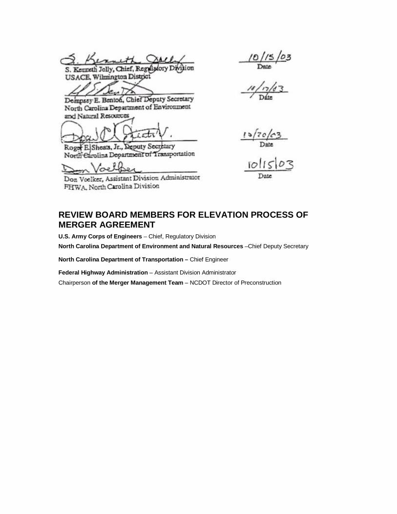
REVIEW BOARD MEMBERS FOR ELEVATION PROCESS OF MERGER AGREEMENT U.S. Army Corps of Engineers – Chief, Regulatory Division
North Carolina Department of Environment and Natura l Resources –Chief Deputy Secretary
North Carolina Department of Transportation – Chief Engineer
Federal Highway Administration – Assistant Division Administrator
Chairperson of the Merger Management Team – NCDOT Director of Preconstruction

Appendix C:
NOAA and DMF Participation in Coastal
Plain Counties

Appendix C
NOAA and DMF Participation in Coastal Plain Counties
Contact NOAA and DMF in these counties to determine their participation on Project Team:
Beaufort Lenoir Bertie Martin Bladen Moore Camden Nash Currituck New Hanover Carteret Northhampton Chowan Onslow Columbus Pamlico Craven Pasquotank Cumberland Pender Dare Perquimans Duplin Pitt Edgecombe Robeson Gates Sampson Greene Scotland Harnett Tyrell Hertford Washington Hoke Wayne Hyde Wake Johnston Jones Lee

Appendix D: Section 6002
Efficient Environmental Reviews for
Project Decisionmaking

Appendix D: Section 6002 - Efficient Environmental Reviews for Project Decisionmaking (a) In General- Subchapter I of chapter 1 of title 23, United States Code, is amended by inserting after section 138 the following: 'Sec. 139. Efficient environmental reviews for project decisionmaking '(a) Definitions- In this section, the following definitions apply: '(1) AGENCY- The term 'agency' means any agency, department, or other unit of Federal, State, local, or Indian tribal government. '(2) ENVIRONMENTAL IMPACT STATEMENT- The term 'environmental impact statement' means the detailed statement of environmental impacts required to be prepared under the National Environmental Policy Act of 1969 (42 U.S.C. 4321 et seq.). '(3) ENVIRONMENTAL REVIEW PROCESS- '(A) IN GENERAL- The term 'environmental review process' means the process for preparing for a project an environmental impact statement, environmental assessment, categorical exclusion, or other document prepared under the National Environmental Policy Act of 1969 (42 U.S.C. 4321 et seq.). '(B) INCLUSIONS- The term 'environmental review process' includes the process for and completion of any environmental permit, approval, review, or study required for a project under any Federal law other than the National Environmental Policy Act of 1969 (42 U.S.C. 4321 et seq.). '(4) LEAD AGENCY- The term 'lead agency' means the Department of Transportation and, if applicable, any State or local governmental entity serving as a joint lead agency pursuant to this section. '(5) MULTIMODAL PROJECT- The term 'multimodal project' means a project funded, in whole or in part, under this title or chapter 53 of title 49 and involving the participation of more than one Department of Transportation administration or agency. '(6) PROJECT- The term 'project' means any highway project, public transportation capital project, or multimodal project that requires the approval of the Secretary. '(7) PROJECT SPONSOR- The term 'project sponsor' means the agency or other entity, including any private or public-private entity, that seeks approval of the Secretary for a project. '(8) STATE TRANSPORTATION DEPARTMENT- The term 'State transportation department' means any statewide agency of a State with responsibility for one or more modes of transportation. '(b) Applicability- '(1) IN GENERAL- The project development procedures in this section are applicable to all projects for which an environmental impact statement is prepared under the National Environmental Policy Act of 1969 and may be applied, to the extent determined appropriate by the Secretary, to other projects for which an environmental document is prepared pursuant to such Act. '(2) FLEXIBILITY- Any authorities granted in this section may be exercised for a project, class of projects, or program of projects. '(c) Lead Agencies- '(1) FEDERAL LEAD AGENCY- The Department of Transportation shall be the Federal lead agency in the environmental review process for a project. '(2) JOINT LEAD AGENCIES- Nothing in this section precludes another agency from being a joint lead agency in accordance with regulations under the National Environmental Policy Act of 1969. '(3) PROJECT SPONSOR AS JOINT LEAD AGENCY- Any project sponsor that is a State or local governmental entity receiving funds under this title or chapter 53 of title 49 for the project shall serve as a joint lead agency with the Department for purposes of preparing any environmental document under the National Environmental Policy Act of 1969 and may prepare any such environmental document required in support of any action or approval by the Secretary if the Federal lead agency furnishes guidance in such preparation and independently evaluates such document and the document is approved and adopted by the Secretary prior to the Secretary taking any subsequent action or making any approval based on such document, whether or not
the Secretary's action or approval results in Federal funding.

with all design and mitigation commitments made jointly by the Secretary and the project sponsor in any environmental document prepared by the project sponsor in accordance with this subsection and that such document is appropriately supplemented if project changes become necessary. '(5) ADOPTION AND USE OF DOCUMENTS- Any environmental document prepared in accordance with this subsection may be adopted or used by any Federal agency making any approval to the same extent that such Federal agency could adopt or use a document prepared by another Federal agency. '(6) ROLES AND RESPONSIBILITY OF LEAD AGENCY- With respect to the environmental review process for any project, the lead agency shall have authority and responsibility-- '(A) to take such actions as are necessary and proper, within the authority of the lead agency, to facilitate the expeditious resolution of the environmental review process for the project; and '(B) to prepare or ensure that any required environmental impact statement or other document required to be completed under the National Environmental Policy Act of 1969 is completed in accordance with this section and applicable Federal law. '(d) Participating Agencies- '(1) IN GENERAL- The lead agency shall be responsible for inviting and designating participating agencies in accordance with this subsection. '(2) INVITATION- The lead agency shall identify, as early as practicable in the environmental review process for a project, any other Federal and non-Federal agencies that may have an interest in the project, and shall invite such agencies to become participating agencies in the environmental review process for the project. The invitation shall set a deadline for responses to be submitted. The deadline may be extended by the lead agency for good cause. '(3) FEDERAL PARTICIPATING AGENCIES- Any Federal agency that is invited by the lead agency to participate in the environmental review process for a project shall be designated as a participating agency by the lead agency unless the invited agency informs the lead agency, in writing, by the deadline specified in the invitation that the invited agency-- '(A) has no jurisdiction or authority with respect to the project; '(B) has no expertise or information relevant to the project; and '(C) does not intend to submit comments on the project. '(4) EFFECT OF DESIGNATION- Designation as a participating agency under this subsection shall not imply that the participating agency-- '(A) supports a proposed project; or '(B) has any jurisdiction over, or special expertise with respect to evaluation of, the project. '(5) COOPERATING AGENCY- A participating agency may also be designated by a lead agency as a 'cooperating agency' under the regulations contained in part 1500 of title 40, Code of Federal Regulations. '(6) DESIGNATIONS FOR CATEGORIES OF PROJECTS- The Secretary may exercise the authorities granted under this subsection for a project, class of projects, or program of projects. '(7) CONCURRENT REVIEWS- Each Federal agency shall, to the maximum extent practicable-- '(A) carry out obligations of the Federal agency under other applicable law concurrently, and in conjunction, with the review required under the National Environmental Policy Act of 1969 (42 U.S.C. 4321 et seq.), unless doing so would impair the ability of the Federal agency to carry out those obligations; and '(B) formulate and implement administrative, policy, and procedural mechanisms to enable the agency to ensure completion of the environmental review process in a timely, coordinated, and environmentally responsible manner. '(e) Project Initiation- The project sponsor shall notify the Secretary of the type of work, termini, length and general location of the proposed project, together with a statement of any Federal approvals anticipated to be necessary for the proposed project, for the purpose of informing the Secretary that the environmental review process should be initiated.
'(f) Purpose and Need

'(1) PARTICIPATION- As early as practicable during the environmental review process, the lead agency shall provide an opportunity for involvement by participating agencies and the public in defining the purpose and need for a project. '(2) DEFINITION- Following participation under paragraph (1), the lead agency shall define the project's purpose and need for purposes of any document which the lead agency is responsible for preparing for the project. '(3) OBJECTIVES- The statement of purpose and need shall include a clear statement of the objectives that the proposed action is intended to achieve, which may include-- '(A) achieving a transportation objective identified in an applicable statewide or metropolitan transportation plan; '(B) supporting land use, economic development, or growth objectives established in applicable Federal, State, local, or tribal plans; and '(C) serving national defense, national security, or other national objectives, as established in Federal laws, plans, or policies. '(4) ALTERNATIVES ANALYSIS- '(A) PARTICIPATION- As early as practicable during the environmental review process, the lead agency shall provide an opportunity for involvement by participating agencies and the public in determining the range of alternatives to be considered for a project. '(B) RANGE OF ALTERNATIVES- Following participation under paragraph (1), the lead agency shall determine the range of alternatives for consideration in any document which the lead agency is responsible for preparing for the project. '(C) METHODOLOGIES- The lead agency also shall determine, in collaboration with participating agencies at appropriate times during the study process, the methodologies to be used and the level of detail required in the analysis of each alternative for a project. '(D) PREFERRED ALTERNATIVE- At the discretion of the lead agency, the preferred alternative for a project, after being identified, may be developed to a higher level of detail than other alternatives in order to facilitate the development of mitigation measures or concurrent compliance with other applicable laws if the lead agency determines that the development of such higher level of detail will not prevent the lead agency from making an impartial decision as to whether to accept another alternative which is being considered in the environmental review process. '(g) Coordination and Scheduling- '(1) COORDINATION PLAN- '(A) IN GENERAL- The lead agency shall establish a plan for coordinating public and agency participation in and comment on the environmental review process for a project or category of projects. The coordination plan may be incorporated into a memorandum of understanding. '(B) SCHEDULE- '(i) IN GENERAL- The lead agency may establish as part of the coordination plan, after consultation with each participating agency for the project and with the State in which the project is located (and, if the State is not the project sponsor, with the project sponsor), a schedule for completion of the environmental review process for the project. '(ii) FACTORS FOR CONSIDERATION- In establishing the schedule, the lead agency shall consider factors such as-- '(I) the responsibilities of participating agencies under applicable laws; '(II) resources available to the cooperating agencies; '(III) overall size and complexity of the project; '(IV) the overall schedule for and cost of the project; and '(V) the sensitivity of the natural and historic resources that could be affected by the project. '(C) CONSISTENCY WITH OTHER TIME PERIODS- A schedule under subparagraph (B) shall be consistent with any other relevant time periods established under Federal law. '(D) MODIFICATION- The lead agency may-- '(i) lengthen a schedule established under subparagraph (B) for good cause; and
'(ii) shorten a schedule only with the concurrence of the affected cooperating agencies.

'(E) DISSEMINATION- A copy of a schedule under subparagraph (B), and of any modifications to the schedule, shall be-- '(i) provided to all participating agencies and to the State transportation department of the State in which the project is located (and, if the State is not the project sponsor, to the project sponsor); and '(ii) made available to the public. '(2) COMMENT DEADLINES- The lead agency shall establish the following deadlines for comment during the environmental review process for a project: '(A) For comments by agencies and the public on a draft environmental impact statement, a period of not more than 60 days after publication in the Federal Register of notice of the date of public availability of such document, unless-- '(i) a different deadline is established by agreement of the lead agency, the project sponsor, and all participating agencies; or '(ii) the deadline is extended by the lead agency for good cause. '(B) For all other comment periods established by the lead agency for agency or public comments in the environmental review process, a period of no more than 30 days from availability of the materials on which comment is requested, unless-- '(i) a different deadline is established by agreement of the lead agency, the project sponsor, and all participating agencies; or '(ii) the deadline is extended by the lead agency for good cause. '(3) DEADLINES FOR DECISIONS UNDER OTHER LAWS- In any case in which a decision under any Federal law relating to a project (including the issuance or denial of a permit or license) is required to be made by the later of the date that is 180 days after the date on which the Secretary made all final decisions of the lead agency with respect to the project, or 180 days after the date on which an application was submitted for the permit or license, the Secretary shall submit to the Committee on Environment and Public Works of the Senate and the Committee on Transportation and Infrastructure of the House of Representatives-- '(A) as soon as practicable after the 180-day period, an initial notice of the failure of the Federal agency to make the decision; and '(B) every 60 days thereafter until such date as all decisions of the Federal agency relating to the project have been made by the Federal agency, an additional notice that describes the number of decisions of the Federal agency that remain outstanding as of the date of the additional notice. '(4) INVOLVEMENT OF THE PUBLIC- Nothing in this subsection shall reduce any time period provided for public comment in the environmental review process under existing Federal law, including a regulation. '(h) Issue Identification and Resolution- '(1) COOPERATION- The lead agency and the participating agencies shall work cooperatively in accordance with this section to identify and resolve issues that could delay completion of the environmental review process or could result in denial of any approvals required for the project under applicable laws. '(2) LEAD AGENCY RESPONSIBILITIES- The lead agency shall make information available to the participating agencies as early as practicable in the environmental review process regarding the environmental and socioeconomic resources located within the project area and the general locations of the alternatives under consideration. Such information may be based on existing data sources, including geographic information systems mapping. '(3) PARTICIPATING AGENCY RESPONSIBILITIES- Based on information received from the lead agency, participating agencies shall identify, as early as practicable, any issues of concern regarding the project's potential environmental or socioeconomic impacts. In this paragraph, issues of concern include any issues that could substantially delay or prevent an agency from granting a permit or other approval that is needed for the project. '(4) ISSUE RESOLUTION- '(A) MEETING OF PARTICIPATING AGENCIES- At any time upon request of a project sponsor or the Governor of a State in which the project is located, the lead agency shall promptly convene a meeting with the relevant participating agencies, the project sponsor, and the Governor (if the
meeting was requested by the Governor) to resolve issues that could delay completion of the

environmental review process or could result in denial of any approvals required for the project under applicable laws. '(B) NOTICE THAT RESOLUTION CANNOT BE ACHIEVED- If a resolution cannot be achieved within 30 days following such a meeting and a determination by the lead agency that all information necessary to resolve the issue has been obtained, the lead agency shall notify the heads of all participating agencies, the project sponsor, the Governor, the Committee on Environment and Public Works of the Senate, the Committee on Transportation and Infrastructure of the House of Representatives, and the Council on Environmental Quality, and shall publish such notification in the Federal Register. '(i) Performance Measurement- The Secretary shall establish a program to measure and report on progress toward improving and expediting the planning and environmental review process. '(j) Assistance to Affected State and Federal Agencies- '(1) IN GENERAL- For a project that is subject to the environmental review process established under this section and for which funds are made available to a State under this title or chapter 53 of title 49, the Secretary may approve a request by the State to provide funds so made available under this title or such chapter 53 to affected Federal agencies (including the Department of Transportation), State agencies, and Indian tribes participating in the environmental review process for the projects in that State or participating in a State process that has been approved by the Secretary for that State. Such funds may be provided only to support activities that directly and meaningfully contribute to expediting and improving transportation project planning and delivery for projects in that State. '(2) ACTIVITIES ELIGIBLE FOR FUNDING- Activities for which funds may be provided under paragraph (1) include transportation planning activities that precede the initiation of the environmental review process, dedicated staffing, training of agency personnel, information gathering and mapping, and development of programmatic agreements. '(3) USE OF FEDERAL LANDS HIGHWAY FUNDS- The Secretary may also use funds made available under section 204 for a project for the purposes specified in this subsection with respect to the environmental review process for the project. '(4) AMOUNTS- Requests under paragraph (1) may be approved only for the additional amounts that the Secretary determines are necessary for the Federal agencies, State agencies, or Indian tribes participating in the environmental review process to meet the time limits for environmental review. '(5) CONDITION- A request under paragraph (1) to expedite time limits for environmental review may be approved only if such time limits are less than the customary time necessary for such review. '(k) Judicial Review and Savings Clause- '(1) JUDICIAL REVIEW- Except as set forth under subsection (l), nothing in this section shall affect the reviewability of any final Federal agency action in a court of the United States or in the court of any State. '(2) SAVINGS CLAUSE- Nothing in this section shall be construed as superseding, amending, or modifying the National Environmental Policy Act of 1969 or any other Federal environmental statute or affect the responsibility of any Federal officer to comply with or enforce any such statute. '(3) LIMITATIONS- Nothing in this section shall preempt or interfere with-- '(A) any practice of seeking, considering, or responding to public comment; or '(B) any power, jurisdiction, responsibility, or authority that a Federal, State, or local government agency, metropolitan planning organization, Indian tribe, or project sponsor has with respect to carrying out a project or any other provisions of law applicable to projects, plans, or programs. '(l) Limitations on Claims- '(1) IN GENERAL- Notwithstanding any other provision of law, a claim arising under Federal law seeking judicial review of a permit, license, or approval issued by a Federal agency for a highway or public transportation capital project shall be barred unless it is filed within 180 days after publication of a notice in the Federal Register announcing that the permit, license, or approval is final pursuant to the law under which the agency action is taken, unless a shorter time is specified
in the Federal law pursuant to which judicial review is allowed. Nothing in this subsection shall

create a right to judicial review or place any limit on filing a claim that a person has violated the terms of a permit, license, or approval. '(2) NEW INFORMATION- The Secretary shall consider new information received after the close of a comment period if the information satisfies the requirements for a supplemental environmental impact statement under section 771.130 of title 23, Code of Federal Regulations. The preparation of a supplemental environmental impact statement when required shall be considered a separate final agency action and the deadline for filing a claim for judicial review of such action shall be 180 days after the date of publication of a notice in the Federal Register announcing such action.'. ](b) Existing Environmental Review Process- Nothing in this section affects any existing State environmental review process, program, agreement, or funding arrangement approved by the Secretary under section 1309 of the Transportation Equity Act for the 21st Century (112 Stat. 232; 23 U.S.C. 109 note) as such section was in effect on the day preceding the date of enactment of the SAFETEA-LU. (c) Conforming Amendment- The analysis for such subchapter is amended by inserting after the item relating to section 138 the following: '139. Efficient environmental reviews for project decisionmaking.'. (d) Repeal- Section 1309 of the Transportation Equity Act for the 21st Century (112 Stat. 232) is
repealed.
1