Embed Size (px)
Citation preview
SENTINEL ASIA STEP 2 – THE OVERVIEW AND EVOLUTION FROM STEP 1
K. Kaku*, A. Ono, M. Kawai
Satellite Applications and Promotion Center, Japan Aerospace Exploration Agency, Tokyo, Japan - (kaku.kazuya,ono.atsushi, kawai.makoto)@jaxa.jp
Commission VIII, JAXA Special Session
KEY WORDS: Sentinel Asia, Disaster Management, Asia-Pacific, Remote Sensing, Web-GIS
ABSTRACT:
The Sentinel Asia (SA) initiative was established in 2005 as a collaboration between space agencies and disaster management agencies, applying remote sensing and Web-GIS technologies to assist disaster management in the Asia-Pacific region. A step-by-step approach for the implementation of this dissemination system was adopted, and SA Step 1 (2006-2007) has achieved its overall goals, demonstrating recent advancement in web-mapping technology and the ICT system. SA Step 1 has served as a good demonstrator project to share disaster-related information obtained by several Earth observation satellites. SA Step 2 (2008-2012) has recently been initiated, aiming to broaden and strengthen the reach of Step 1. The experience of SA Step 1 has given us valuable lessons. In this paper, lessons learned from SA Step 1 and how to cope with them in SA Step 2 as well as the overview of SA are presented.
* Corresponding author.
1. INTRODUCTION
1.1 Background
According to statistics (by the Natural Disasters Data Book-2006), the Asian region has been seriously damaged by natural disasters over the last 30 years as shown in Figure 1. This is compounded by its high levels of population (close to 3 billion). Disasters occurring in Asia comprise 37 percent of the worldwide total. The region sustained 57 percent of global fatalities and has 89 percent of the total victims associated with such disasters.
Figure 1. Natural Disaster Damages in Asia, 1975-2006(quoted from “ ADRC-Natural Disasters Data Book-2006”originated in CRED-EMDAT, 2006)
Under these circumstances, the Asia-Pacific Regional Space Agency Forum (APRSAF) proposed Sentinel Asia in 2005 to showcase the value and impact of Earth observation technologies, combined with near real-time Internet dissemination methods and Web-GIS mapping tools for disaster management support in the Asia-Pacific region (Kaku et al., 2006; Kozawa and Kaku, 2007). APRSAF was established in 1993 in response to the declaration adopted by the Asia-Pacific
International Space Year Conference (APIC) in 1992, to enhance the development of each country’s space program and to exchange views on future cooperation in space activities inthe Asia-Pacific region. It was designed originally to provide opportunities for regional space agencies and associated governmental bodies to exchange technical views, opinions, and information on national space programs and space resources.
1.2 Objective of This Paper
A step-by-step approach for the implementation of Sentinel Asia was adopted as follows:-Step 1: Implementation of the backbone Sentinel Asia datadissemination system as a pilot project, to showcase the value and impact of the technology using standard Internet dissemination systems (2006-2007)-Step 2: Expansion of the Step 1 with new satellite communication systems, and enhancement of activities based on experiences in Step 1 and new requirements (2008-2012).(Kaku, 2008b)-Step 3: Establishment of a comprehensive disaster management support system (2013 onwards)
SA Step 1 has achieved its overall goals. The Sentinel Asia website has operated since October 2006. It has served as a good demonstrator project. The experience of SA Step1 has given us valuable lessons. In this paper, lessons learned from SA Step 1 and how to cope with them in SA Step 2 as well as the overview of SA are presented.
2. OVERVIEW OF SENTINEL ASIA
The Sentinel Asia (SA) initiative is a collaboration between space agencies and disaster management agencies, applying remote sensing and Web-GIS technologies to assist disaster management in the Asia-Pacific region. It aims to:
International Archives of the Photogrammetry, Remote Sensing and Spatial Information Science, Volume XXXVIII, Part 8, Kyoto Japan 2010
56
- Improve safety in society by ICT (Information and Communication Technology) and space technology- Improve the speed and accuracy of disaster preparedness and early warnings- Minimize the number of victims and social/economic lossesSA is a voluntary initiative led by APRSAF. Its goal is to share disaster information in near-real-time across the Asia-Pacific region, using Web-GIS platform (http://sentinel.tksc.jaxa.jp/).Its architecture is designed to operate initially as an internet-based, node-distributed information distribution backbone,eventually distributing relevant satellite and in situ spatial information on multiple hazards in the Asia-Pacific region.
2.1 Framework
SA is promoted with cooperation amongst the space community (APRSAF), the international community (UN ESCAP, UN OOSA, ASEAN, the Asian Institute of Technology (AIT), and so on), and the disaster reduction community (the Asian Disaster Reduction Center (ADRC) and its memberorganizations). To support the implementation of the SA project, a Joint Project Team (JPT) was organized. Membership in the JPT is open to all disaster prevention organizations and regional/international organizations that are prepared to contribute their experiences and technical capabilities and wish to participate in technical aspects of disaster information sharing activities. JPT consists of 58 organizations from 23countries/region and nine international organizations at the time of writing. The Japan Aerospace Exploration Agency (JAXA) is a secretariat of the JPT.
2.2 Activities
The main activities of SA are as follows:- Emergency observation in case of major disasters by Earth observation satellites via observation requests of JPT and ADRC members- Wildfire monitoring, flood monitoring, and glacial lake outburst (GLOF) monitoring- Capacity building for utilization of satellite images and human resources development for disaster management
2.2.1 Emergency Observation: In Step 1, JAXA’s Advanced Land Observing Satellite (ALOS) and Indian Remote Sensing Satellites (IRS) of the Indian Space Research Organization(ISRO) have carried out emergency observations in the case of major disasters in the Asia-Pacific region. Emergency observation requests of JPT members and ADRC members are passed to space agencies through the ADRC.
Figure 2. Flow of emergency observation.
In Step 2, a new framework, the Data Analysis Node (DAN), is organized to provide analyzed images. The overall flow of Sentinel Asia emergency observation is shown in Figure 3.
2.2.2 Wildfire Monitoring: Wildfire is a major and recurring phenomenon that has a serious impact on property and human health, affecting many countries in the region. Compared to other disasters in the area, it does not necessarily cause many immediate fatalities. However, it has a serious impact on property and human health due to smoke. Responding to requirements from Asian countries, wildfire monitoring has been chosen as one of SA’s activities. Having accurate information on the location and intensity of the fires, and subsequent control of wildfire, are therefore very important and urgent tasks across the region. SA primarily addresses the issue of near real-time information distribution on wildfires in the region. Furthermore, its effects are of great relevance at both a regional and a global level, and accordingly they bear substantial influence on global warming. For example, the fourth edition of the scientific report on global warming in 2007by the Intergovernmental Panel on Climate Change (IPCC) pointed out that a huge amount of carbon dioxide (CO2) has been emitted from the wildfires. The emitted CO2 from biomass burning worldwide per year is 6-15 gigaton (Denman et al., 2007); while the total emitted CO2 from fuel burning is 27 gigaton. For comparison, according to the National Greenhouse Gas Inventory Report of Japan dated April 2009, it is reported that the emitted CO2 from biomass burning in Japan in fiscal 2007 is 1.3 gigaton. Furthermore, a fire changes a forest, which is originally a sink of CO2, into a source of CO2 emission. In view of these circumstances, wildfire management is very important and an urgent task in the mitigation of global warming.
The Wildfire Monitoring Working Group (WG) has been organized under international cooperation with WG members of Hokkaido University, the University of Tokyo, the Center for Remote Imaging, Sensing and Processing (CRISP) of National University of Singapore, the Asian Institute of Technology (AIT), the Commonwealth Scientific and Industrial Research Organisation (CSIRO) in Australia, the National Institute of Aeronautics and Space (LAPAN) in Indonesia, and JAXA, among others. Prof. M. Fukuda of the University of Alaska Fairbanks was selected as the WG chair. The project is operatedunder international cooperation in the framework of Sentinel Asia based on the experience and knowledge of similar activities such as for boreal forest/tundra fire in the Siberia/Alaska and for bush/shrub/grass fire in Australia (Held et al., 2003).
Figure 3. Scheme of wildfire monitoring in Sentinel Asia
International Archives of the Photogrammetry, Remote Sensing and Spatial Information Science, Volume XXXVIII, Part 8, Kyoto Japan 2010
57
The main activities of Sentinel Asia wildfire control are as follows:- To implement a near real-time “wildfire observing system” covering the Asia-Pacific region, using the agreed-on node-distributed Sentinel Asia backbone and Web-GIS visualization system. AIT, the University of Tokyo, CSIRO, and CRISP are providing hotspot information, which is shown in Figure 3- To coordinate activities such as validation of fire detection across the region in order to improve the hotspots detection algorithm. (Kaku et al., 2008a; Kaku et al., 2009; Honda et al., 2008; Kagiya et al., 2008; Kushida et al., 2008; Nakau et al., 2008; Kaku et al., 2010a)
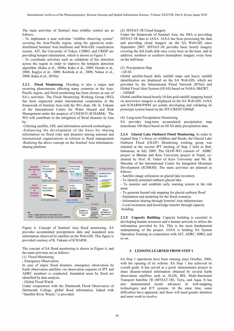
2.2.3 Flood Monitoring: Flooding is also a major and recurring phenomenon affecting many countries in the Asia-Pacific region, and flood monitoring has been chosen as one of SA’s activities. The Flood Monitoring Working Group (WG) has been organized under international cooperation in the framework of Sentinel Asia with the WG chair, Mr. K. Fukami of the International Centre for Water Hazard and Risk Management under the auspices of UNESCO (ICHARM). The WG will contribute to the mitigation of flood disasters in Asia by:-Utilizing satellite, GIS, and information network technologies-Enhancing the development of the basis for sharinginformation on flood risks and disasters among national andinternational organizations in relation to flood management-Realizing the above concept on the Sentinel Asia information-sharing platform
Figure 4. Concept of Sentinel Asia flood monitoring. SA provides accumulated precipitation data and inundated area information observed by satellite on the Web-GIS. This figure is provided courtesy of K. Fukami of ICHARM.
The concept of SA flood monitoring is shown in Figure 4, and the main activities are as follows:(1) Flood Monitoring- Emergency ObservationIn case of major flood disasters, emergency observation by Earth observation satellites via observation requests of JPT and ADRC members is conducted. Inundated areas by flood are identified by data analysis.- Global Flood WatchUnder cooperation with the Dartmouth Flood Observatory of Dartmouth College, global flood information, linked with “Satellite River Watch,” is provided.
(2) MTSAT-1R Cloud ImageryUnder the framework of Sentinel Asia, the JMA is providing MTSAT-1R data to JAXA. JAXA has been processing the data and providing cloud imagery on the SA Web-GIS since September 2007. MTSAT-1R provides basic hourly imagery covering the full Earth disk once every hour on the hour, and inaddition, northern or southern hemisphere imagery every hour on the half-hour.
(3) Precipitation Map- GFAS Global satellite-based daily rainfall maps and heavy rainfall identification are displayed on the SA Web-GIS, which are provided by the International Flood Network (IFNet) and Global Flood Alert System (GFAS) based on NASA-3B42RT.- GSMaPGlobal satellite-based hourly/10-km-grid rainfall mapping based on microwave imagery is displayed on the SA Web-GIS. JAXA and ICHARM/PWRI are jointly developing and validating its prototype system based on the JST-CREST GSMaP.
(4) Long-term Precipitation MonitoringSA provides long-term accumulated precipitation map (maximum 100 days) based on GFAS daily precipitation data.
2.2.4 Glacial Lake Outburst Flood Monitoring: In order to expand Step 1’s focus on wildfires and floods, the Glacial Lake Outburst Flood (GLOF) Monitoring working group was initiated at the second JPT meeting of Step 2 held in Bali, Indonesia, in July 2009. The GLOF-WG consists of ADRC project in Bhutan and Keio University project in Nepal, co-chaired by Prof. H. Fukui of Keio University and Mr. B.Shrestha of the International Center for Integrated Mountain Development (ICIMOD). The main activities are planned as follows:- Satellite image utilization on glacial lake inventory- To identify potential outburst glacial lake. - To monitor and establish early warning system in the risk areas- To generate hazard risk mapping for glacial outburst flood- Simulation and modeling for the flood scenarios- Information sharing through Sentinel Asia infrastructure- Local awareness and knowledge transfer through capacitybuilding
2.2.5 Capacity Building: Capacity building is essential to developing human resources and a human network to utilize the information provided by SA. This is the most fundamental underpinning of the project. JAXA is holding SA System Operation Training in cooperation with AIT, ADRC, ISRO, and so on.
3. LESSONS LEARNED FROM STEP 1
SA Step 1 operations have been running since October, 2006,with the opening of its website. SA Step 1 has achieved its overall goals. It has served as a good demonstrator project to share disaster-related information obtained by several Earth observation satellites such as ALOS, IRS, Multi-functional Transport Satellite 1R (MTSAT-1R), Terra, and Aqua. It has also demonstrated recent advances in web-mapping technologies and ICT systems. At the same time, some difficulties have appeared, and these will need greater attention and more work to resolve.
International Archives of the Photogrammetry, Remote Sensing and Spatial Information Science, Volume XXXVIII, Part 8, Kyoto Japan 2010
58
3.1 Data TransmissionIt was found that there were narrow-band areas in Asia where it is hard to see information via the Internet, particularly Web-GIS.
3.2 Value-added Information
Users of disaster management organizations request easily comprehensible interpretations from satellite images rather than satellite data, while users of space agencies and institutesrequest GeoTIFF data and/or raw data for their analysis.
3.3 Robust and User-friendly Information-Sharing Platform
Single construction of Step 1 website system caused suspension of operation several times due to server maintenance and so on.More robust and user-friendly website system is required.
3.4 Human Network
A good human network between the space and disastermanagement communities has been recognized to be the most fundamental underpinning of the project.
4. Sentinel ASIA STEP 2
At APRSAF-14 held in Bangalore, India, in November 2007, the recommendation on SA Step 2 was adopted, and the new JPT meeting was held in Kobe, Japan, in June, 2008. Thus, the Sentinel Asia Step 2 project was initiated.
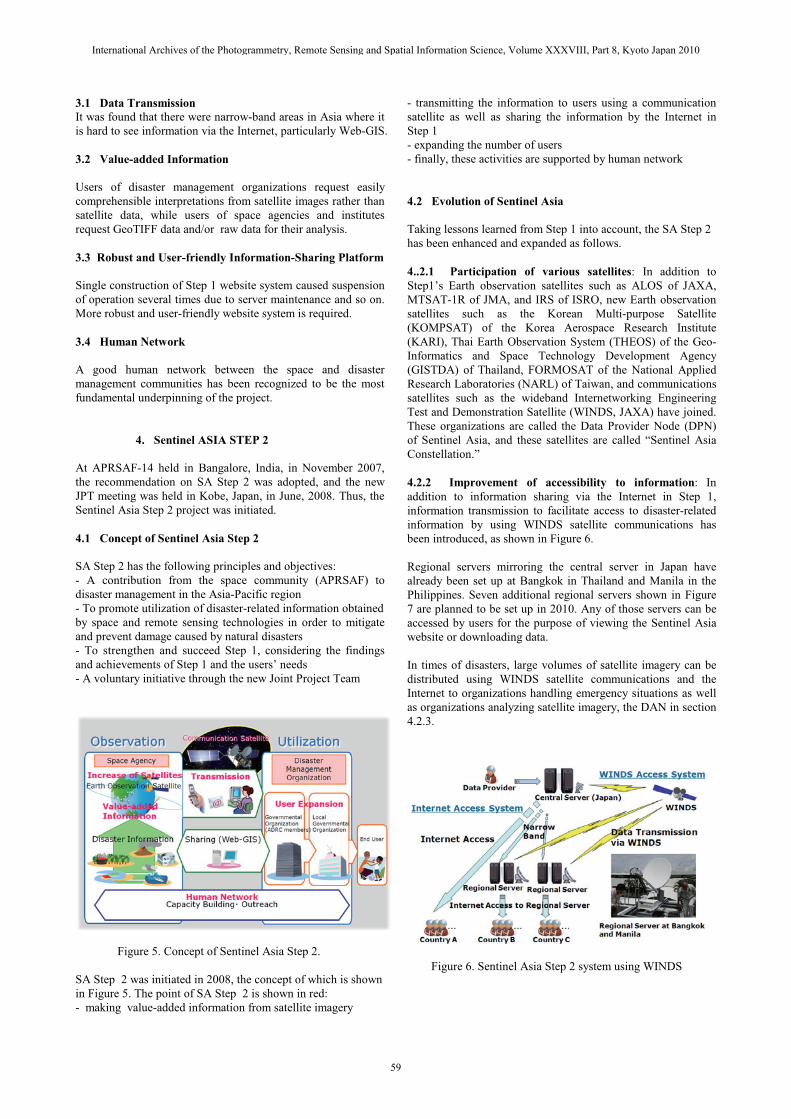
4.1 Concept of Sentinel Asia Step 2
SA Step 2 has the following principles and objectives:- A contribution from the space community (APRSAF) todisaster management in the Asia-Pacific region- To promote utilization of disaster-related information obtainedby space and remote sensing technologies in order to mitigateand prevent damage caused by natural disasters- To strengthen and succeed Step 1, considering the findings and achievements of Step 1 and the users’ needs- A voluntary initiative through the new Joint Project Team
Figure 5. Concept of Sentinel Asia Step 2.
SA Step 2 was initiated in 2008, the concept of which is shownin Figure 5. The point of SA Step 2 is shown in red:- making value-added information from satellite imagery
- transmitting the information to users using a communicationsatellite as well as sharing the information by the Internet in Step 1- expanding the number of users- finally, these activities are supported by human network
4.2 Evolution of Sentinel Asia
Taking lessons learned from Step 1 into account, the SA Step 2has been enhanced and expanded as follows.
4..2.1 Participation of various satellites: In addition toStep1’s Earth observation satellites such as ALOS of JAXA, MTSAT-1R of JMA, and IRS of ISRO, new Earth observation satellites such as the Korean Multi-purpose Satellite (KOMPSAT) of the Korea Aerospace Research Institute (KARI), Thai Earth Observation System (THEOS) of the Geo-Informatics and Space Technology Development Agency (GISTDA) of Thailand, FORMOSAT of the National Applied Research Laboratories (NARL) of Taiwan, and communications satellites such as the wideband Internetworking Engineering Test and Demonstration Satellite (WINDS, JAXA) have joined.These organizations are called the Data Provider Node (DPN) of Sentinel Asia, and these satellites are called “Sentinel Asia Constellation.”
4.2.2 Improvement of accessibility to information: In addition to information sharing via the Internet in Step 1, information transmission to facilitate access to disaster-related information by using WINDS satellite communications hasbeen introduced, as shown in Figure 6.
Regional servers mirroring the central server in Japan have already been set up at Bangkok in Thailand and Manila in the Philippines. Seven additional regional servers shown in Figure 7 are planned to be set up in 2010. Any of those servers can be accessed by users for the purpose of viewing the Sentinel Asia website or downloading data.
In times of disasters, large volumes of satellite imagery can bedistributed using WINDS satellite communications and the Internet to organizations handling emergency situations as well as organizations analyzing satellite imagery, the DAN in section 4.2.3.
Figure 6. Sentinel Asia Step 2 system using WINDS
International Archives of the Photogrammetry, Remote Sensing and Spatial Information Science, Volume XXXVIII, Part 8, Kyoto Japan 2010
59
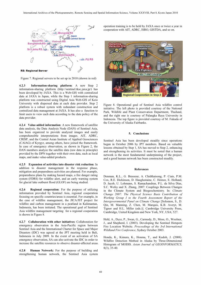
Figure 7. Regional servers to be set up in 2010 (shown in red)
4.2.3 Information-sharing platform: A new Step 2 information-sharing platform (http://sentinel.tksc.jaxa.jp/) has been developed by JAXA. This is a Web-GIS with centralized data at JAXA in Japan, while the Step 1 information-sharing platform was constructed using Digital Asia Web-GIS of Keio University with dispersed data at each data provider. Step 2 platform is a robust system with redundant construction andcentralized data management at JAXA. It has also a function to limit users to view each data according to the data policy of the data provider.
4.2.4 Value-added information: A new framework of satellite data analysis, the Data Analysis Node (DAN) of Sentinel Asia,has been organized to provide analyzed images and easily comprehensible interpretations from images. AIT, ADRC,CRISP, and the Central Asian Institute of Applied Geosciences (CAIAG) of Kyrgyz, among others, have joined the framework.In case of emergency observation, as shown in Figure 2, the DAN members analyze the satellite data (raw data in principle)provided by the DPN together with their own data, such as local maps, and make value-added products.
4.2.5 Expansion of activities into disaster risk reduction: In addition to disaster management in the response phase, mitigation and preparedness activities are planned. For example, preparedness plans by making hazard maps, a fire danger rating system (FDRS) for wildfire alert, and an early warning system for glacial lake outburst flood (GLOF) are being studied.
4.2.6 Regional cooperation: For the purpose of utilizing information provided by Sentinel Asia, regional cooperation focusing on specific countries/areas is essential. For example, in the case of wildfire management, the JICA/JST project for wildfire and carbon management in a peatland in Kalimantan, Indonesia, has been initiated. The operational goal of Sentinel Asia wildfire management targeting for a regional cooperation is shown in Figure 8.
4.2.7 Collaboration with other initiatives: Collaboration for emergency observation in the Asia-Pacific region between Sentinel Asia and the International Charter for Space and Major Disasters (IDC) was agreed at the JPT meeting held in Bali, Indonesia in July 2009. In the event of an activation of SA emergency observation, SA can also activate the IDC in order to increase the satellite resources to observe disaster-affected areas.
4.2.8 Human Network: For the purpose of building and strengthening human network, the Sentinel Asia system
operation training is to be held by JAXA once or twice a year in cooperation with AIT, ADRC, ISRO, GISTDA, and so on.
Figure 8. Operational goal of Sentinel Asia wildfire controlinitiative. The left photo is provided courtesy of the National Park, Wildlife and Plant Conservation Department, Thailand, and the right one is courtesy of Palangka Raya University in Indonesia. The top figure is provided courtesy of M. Fukuda of the University of Alaska Fairbanks.
5. Conclusions
Sentinel Asia has been developed steadily since operations began in October 2006 by JPT members. Based on valuable lessons obtained by Step 1, SA has moved to Step 2, enhancing and strengthening its activities. It must be noted that a human network is the most fundamental underpinning of the project,and a good human network has been constructed steadily.
References
Denman, K.L., G. Brasseur, A. Chidthaisong, P. Ciais, P.M. Cox, R.E. Dickinson, D. Hauglustaine, C. Heinze, E. Holland, D. Jacob, U. Lohmann, S. Ramachandran, P.L. da Silva Dias, S.C. Wofsy and X. Zhang, 2007: Couplings Between Changes in the Climate System and Biogeochemistry. In: Climate Change 2007: The Physical Science Basis Contribution ofWorking Group I to the Fourth Assessment Report of the Intergovernmental Panel on Climate Change [Solomon, S., D. Qin, M. Manning, Z. Chen, M. Marquis, K.B. Averyt, M. Tignor and H.L. Miller (eds.)]. Cambridge University Press, Cambridge, United Kingdom and New York, NY, USA; 527.
Held, A., Dyce, P., Swan, G., Carmody, D., Moss, O., Woolner,J., and Shepherd, I. (2003). Developing the Sentinel HotspotsFire Location Website. Proceedings of the 3rd InternationalWildland Fire Conference, Sydney October 2003.
Honda, K., Kimura, K., Honma, T., and Kudoh, J. (2008). Wildfire Detection Method in Alaska by Three-Dimensional Histogram of MODIS. Asian Journal of GEOINFORMATICS,8(3), 35-40.
International Archives of the Photogrammetry, Remote Sensing and Spatial Information Science, Volume XXXVIII, Part 8, Kyoto Japan 2010
60
Kagiya, Y., Kimura, K., Honma, T., and Nakau, K. (2008). A Study of an Algorithm to Detect Wildfire with the Edges of Smoke Plumes. Asian Journal of GEOINFORMATICS, 8(3), 29-33.
Kaku, K., Held, A., Fukui, H., and Arakida, M. (2006). Sentinel Asia Initiative for Disaster Management Support in the Asia-Pacific Region. Proceedings of SPIE, 6412.
Kaku, K., and Fukuda, M. (2008a). Overview of Sentinel Asia’s Approach to Wild Fire Detection Using Remote Sensing Technology. Asian Journal of GEOINFORMATICS, 8(3), 3-11.
Kaku, K. (2008b). Sentinel Asia – the next step. Risk Wise, 183-186. Leicester (UK), Tudor Rose.
Kaku, K., Kushida, K., Honma, T., and Fukuda, M. (2009). An Evaluation Method for Hotspot Detection Algorithms using Web-GIS. Asian Journal of GEOINFORMATICS, 9(4), 19-27.
Kaku, K., and Tokuno, M. (2010a). Developing Hotspots Monitoring Web-GIS using MTSAT Infrared Data. Asian Journal of GEOINFORMATICS, 10(1), 27-36.
Kaku, K., Fukami, K., Honma, T., and Fukuda, M. (2010b). Sentinel Asia – the Overview and Prospect. Asian Journal of GEOINFORMATICS, in press.
Kozawa, H., and Kaku, K. (2007). Sentinel Asia: supporting disaster management in the Asia-Pacific region. The Full Picture, 174-176. Leicester (UK), Tudor Rose.Kushida, K., Liew, S.C., Msihigdorj, O., Kaku, K., Fukuda, M., and Honma, T. (2008). A Stochastic Fire Detection Model in 4�m Constructed by using ASTER and MODIS. Asian Journal of GEOINFORMATICS, 8(3), 19-27.
Nakau, K., Fukuda, M., and Nagamine, Y. (2008). An Improvement of Wild Fire Detection Algorithm Using 2-Demensional Distribution and Validation of Wild FireDetection Algorithm in Boreal Area. Asian Journal of GEOINFORMATICS, 8(3), 51-57.
National Greenhouse Gas Inventory Report of Japan, edited by Greenhouse Gas Inventory Office of JAPAN (GIO), Center for Global Environmental Research (CGER), and National Institute for Environmental Studies (NIES). Ministry of the Environment, Japan, April 2009.
Natural Disasters Data Book-2006. analyzed by Asian Disaster Reduction Center by CRED EM-DAT database, March 2007. http://www.adrc.asia/publications/databook/DB2006_e.html
Acknowledgements
The authors wish to gratefully acknowledge all the members of Sentinel Asia project for their cooperation in promoting the project.
International Archives of the Photogrammetry, Remote Sensing and Spatial Information Science, Volume XXXVIII, Part 8, Kyoto Japan 2010
61