Embed Size (px)
Citation preview

September 2017 (Revised April 2020)

1
Table of Contents
ACKNOWLEDGMENTS: .......................................................................................................................... 3 PREFACE ............................................................................................................................................... 4 1 INTRODUCTION ....................................................................................................................... 6
1.1 Wayfinding in Virginia ......................................................................................................... 6 1.2 Policy Overview .................................................................................................................. 6
2 WAYFINDING SIGN PROGRAM DEVELOPMENT PROCESS .......................................................... 6 2.1 Roles and Responsibilities ................................................................................................... 6
2.1.1 Funding and other Sponsor Responsibilities ........................................................ 7 2.2 Wayfinding Sign Program Development Outline ................................................................ 8
2.2.1 Program Initiation ................................................................................................ 9 2.2.2 “Kick Off” Meeting with VDOT ........................................................................... 12 2.2.3 Wayfinding Sign Plans (Construction Documents) ............................................. 12 2.2.4 Permit Application and Approval: ...................................................................... 17 2.2.5 Implementation .................................................................................................. 17 2.2.6 Close‐Out and As‐Built Plans .............................................................................. 18 2.2.7 Maintain and Modify .......................................................................................... 18
3 PLANNING AND DESIGNING A WAYFINDING PROGRAM .......................................................... 19 3.1 Destination Selection ........................................................................................................ 19
3.1.1 Criteria for Acceptable Destinations .................................................................. 19 3.1.2 List of Acceptable Destinations .......................................................................... 21 3.1.3 List of Unacceptable Destinations ...................................................................... 23
3.2 Placement and Routing ..................................................................................................... 25 3.2.1 Prioritization of Wayfinding Signs ...................................................................... 25 3.2.2 Wayfinding Sign Types and Location .................................................................. 26 3.2.3 Routes to Wayfinding Destinations .................................................................... 28 3.2.4 Sign Placement ................................................................................................... 29 3.2.5 Elements of Wayfinding Sign Design .................................................................. 30 3.2.6 Wayfinding Systems Crossing Multiple Jurisdictions .......................................... 33
3.3 Sign Design Specifications ................................................................................................. 33 3.4 Signing and Sealing ........................................................................................................... 33
4 CONSTRUCTION ..................................................................................................................... 34 4.1 Permitting ......................................................................................................................... 34 4.2 Sign Installation ................................................................................................................ 34 4.3 Develop and Submit As‐built Plans ................................................................................... 34 4.4 Post‐Construction Assessment ......................................................................................... 35
5 MAINTENANCE ....................................................................................................................... 35 5.1 Maintenance Plan ............................................................................................................. 35 5.2 Modifications to Existing Wayfinding Sign Program ......................................................... 36
6 GLOSSARY .............................................................................................................................. 37 REFERENCES ........................................................................................................................................ 40 APPENDIX ............................................................................................................................................ 41
Appendix A: Experimental and Pilot Wayfinding Sign Programs in Virginia ................................... 41 Appendix B: Wayfinding Sign Program Forms for Project Development ........................................ 42

2
I. LISTOFTABLES
Table 1: Acceptable Cultural Destinations ................................................................................................................... 21
Table 2: Acceptable Recreational Destinations ........................................................................................................... 22
Table 3: Acceptable Historic Destinations ................................................................................................................... 23
Table 4: List of Unacceptable Destinations ................................................................................................................. 24
LISTOFFIGURES
Figure 1: Wayfinding Sign Program Development Phases ............................................................................................. 9
Figure 2: Family of Wayfinding Gateway Sign Concepts.............................................................................................. 10
Figure 3: Example of a Wayfinding Concept Master Plan............................................................................................ 11
Figure 4: Example Wayfinding Map Legend ................................................................................................................ 12
Figure 5: Example Masterplan Map with Signs in Proper Orientation ........................................................................ 14
Figure 6: Example, Detail For Sub Gateway Sign ......................................................................................................... 15
Figure 7 : A Final Wayfinding Sign Plan may utilize VDOT Roadway Plans as a base................................................... 15
Figure 8: Example of a schematic Wayfinding Site Plan .............................................................................................. 16
Figure 9: Example of Local Destination ....................................................................................................................... 19
Figure 10: Destination Preference ............................................................................................................................... 20
Figure 11: Vineyard Near Monticello, Virginia ............................................................................................................. 20
Figure 12: Example of a Wayfinding Sign System ........................................................................................................ 25
Figure 13: Schematic Diagram of a .............................................................................................................................. 26
Figure 14: Example Gateway Sign ................................................................................................................................ 27
Figure 15: Example Sub‐Region Gateway Sign ............................................................................................................ 27
Figure 16: Example Destination Directional Sign ......................................................................................................... 27
Figure 17: Example Wayfinding Corridor Marker ........................................................................................................ 28
Figure 18: Wayfinding Sign Design Summary .............................................................................................................. 30
Figure 19: Wayfinding Signs, Showing Arrow Placement and Enhancement Markers ................................................ 31
Figure 20: VDOT Directional Signs ............................................................................................................................... 32

3
ACKNOWLEDGMENT:
Virginia is rich in historic, cultural, and recreational destinations and communities are increasingly recognizing the
economic benefits of marketing to the public through specialty directional signing. Wayfinding programs are
considered an integral part of promoting tourism and competing for the economic benefits. A well‐crafted
wayfinding sign system provides an opportunity to educate and inspire the travelling public and promote visitation
to some of Virginia’s great destinations.
With this understanding and the commitment to provide clear and consistent signing to the travelling public, the
Virginia Department of Transportation (VDOT) collaborated with industry stakeholders to develop the Community
Wayfinding Manual, which provides specific guidance on how to develop and implement wayfinding sign programs
on the VDOT roadway network. The Manual builds upon the guidance provided in the Manual of Uniform Traffic
Control Devices (MUTCD) and offers supplementary policies, procedures, and guidelines unique to Virginia so that
wayfinding signs can coexist in congruence with other essential directional and guide signs.
VDOT encourages the use of this manual and offers support and guidance to those communities interested in the
development of a wayfinding program.
Compiling this manual has been a collaborative effort of many partners: The Federal Highway Administration,
Virginia Municipal League, Virginia Association of Counties, Virginia Tourism Corporation, various counties and
cities. A special thanks to the following individuals for their contribution and partnership.
A list of individuals in alphabetical order:
EXTERNAL PARTNERS: Janet Areson (Va. Municipal League) . Robyn Bailey (Loudoun County) . Troy Dawson (Art
and Sign F/X, Inc.) . Kathlene Frazier (Frazier & Associates) . Lara Fritts (Executive Director of the Southeast Fairfax
Development Corporation). Valerie Guffy (Virginia Tourism Corporation) . Sandy Hanger (Frazier & Associates) .
Amanda Harmon (Kimley‐Horn) . Marie Henderson (Virginia Tourism Corporation) . Massoud Hojatzadeh (Fairfax
County) . Warren Hughes (ATCS) . Martha Kapitanov (FHWA) . Karen King (FHWA) . Larry Land (Virginia Association
of Counties) . Margaret Moncure (Stafford County) . Hugh McGee (Vanasse Hangen Brustlin) . Tom O’Connor
(Stafford County) . Mike Tantillo (VHB) . Jack Tuttle (City of Williamsburg) . Josue Yambo (FHWA Highway Safety
Engineer).
VDOT: Mutaz Alkhadra (Permitting) . David Beale . Sean Becker . Colleen Bolden (Outdoor Advertising) . Anne
Booker . Gary Bowman . Al Bryan . Rick Burgess . Harry Campbell . Mike Corwin . Ben Cottrell (Research Council) .
Bryant Cuffy (Outdoor Advertising) . Randy Dittberner . Ali Farhangi . Thom Folse . Keith Goodrich (Permitting) .
Steven Hall . Peter Hedrich . Mark Hodges . Phil Hopkins (Transportation Planning) . Erica Jeter (Local Assistance) .
Karl Larson (Structure and Bridge) . Thomas Lee . Marc Lipschultz . Ray Khoury . Donald Logan . Andy McLaughlin .
Cindy Mitchell . Vanloan Nguyen . Jerry Pauley . David Perreira . Brett Randolph . Larry Settle . Nathan Umberger .
Robert Vilak . Nhan N. Vu . Keith Wandtke (Policy) . Robert Weber III . Buford Wheeler . Anne Margaret White .
Mike Zink.

4
PREFACE
According to the Manual on Uniform Traffic Control Devices (MUTCD), community wayfinding guide signs are part
of a coordinated and continuous system of signs that direct tourists and visitors to key civic institutions, cultural,
historical and recreational attractions and other destinations within a city or a local urbanized or downtown area.
Community wayfinding signs differ from regulatory or general guide signs in that they may have a unique graphical
theme, logo (or branding), font and color scheme by which key destinations within a specific community are
identified.
Intended Use of Manual This manual was created to supplement the MUTCD in order to provide a consistent and uniform approach for
developing, implementing, and maintaining wayfinding sign programs in the Commonwealth of Virginia in addition
to outlining VDOT’s step‐by‐step submittal and approval process.
This manual is not intended to address wayfinding for pedestrian and shared use path facilities, although
wayfinding on such facilities maintained by VDOT should adhere to the principles provided herein.
Abbreviations and Acronyms
ALUE ‐ Area Land Use Engineer (District) MUTCD – Manual on Uniform Traffic Control Devices
CTB – Commonwealth Transportation Board SGS – Supplemental Guide Signs
DTE – District Traffic Engineer TED – Traffic Engineering Division
FHWA – Federal Highway Administration TODS – Tourist‐Oriented Directional Signs
GMSS – General Motorist Services Signs VDOT – Virginia Department of Transportation
IDSP – Integrated Directional Signing Program VWAPM‐ Virginia Work Area Protection Manual
Logo – Specific Travel Service Signing WSPA – Wayfinding Signs Program Administrator
LUP – Land Use Permit

5
Organization of the Manual This manual is organized into the following parts:
Part 1: Introduction. Part 1 introduces the wayfinding concept.
Part 2: Wayfinding Sign Program Development Process. Part 2 defines the Sponsor’s role and responsibilities and
outlines the steps of the wayfinding system development process that must be followed to gain VDOT’s plan and
permit approval.
Part 3: Planning and Design. Part 3 defines the types of wayfinding signs, route selection, sign placement and the
basic elements of sign design required for approval.
Part 4: Construction. Part 4 briefly outlines the requirements for the Permit Application, implementation
(construction) and submittal of “As‐Built” plans.
Part 5: Maintenance. Part 5 discusses proper close‐out and maintenance procedures and provides guidance if
modifications to the wayfinding system are necessary.
Part 6: Glossary. The glossary contains the definition of terms referenced in this manual.
References. Resources that are directly referenced in this manual and/or will be helpful toward the completion of
a wayfinding program are summarized in this list.
Appendix. The Appendix includes background information on the first experimental wayfinding project and other
“Pilot” wayfinding projects in Virginia as well as forms associated with project initiation and plan submittals.

6
1 INTRODUCTION
1.1 Wayfinding in Virginia Wayfinding signs are intended to create a branding associated with the identity of a community, sub‐region or
region, while providing drivers and pedestrians with directional guidance to destinations within the community. It
is important to note that some regions could be multi‐jurisdictional and spread across several counties, while
others may be areas located within one county. Communities typically consider wayfinding to be an integral part
of their pursuit to promote tourism and to successfully compete for the economic benefits that tourism brings.
Wayfinding signs are typically installed alongside roadways within state maintained right‐of‐way. As such, the
Virginia Department of Transportation (VDOT) has a vested interest in establishing a policy for the appropriate use
of community wayfinding signs for program consistency, sign uniformity and motorist expectation.
It should be noted that wayfinding signs located outside VDOT’s right‐of‐way are subject to the requirements of
the Laws of Virginia relating to Outdoor Advertisement and Junkyards (2005 Edition) and subsequent authority
granted to VDOT.
1.2 Policy Overview The VDOT Wayfinding Sign Program Manual establishes a consistent statewide policy and outlines step‐by step
procedures for localities to gain VDOT concurrence on developing and implementing wayfinding signs (via the
VDOT Permit Process) for their particular community. Excluding Arlington and Henrico Counties, which maintain
their own Secondary Highway systems and select Primaries, these guidelines will generally apply to communities
outside of cities and towns along VDOT maintained Right‐of‐Way.
While the VDOT wayfinding policy is similar to the Integrated Directional Signing Program (IDSP) in some respects,
the VDOT IDSP Contractor does not install or maintain wayfinding signs; VDOT issues a land use permit to the
Sponsor or its agent authorizing the installation and maintenance of wayfinding signs within state maintained
right‐of‐way.
For wayfinding signs to harmoniously co‐exist among other VDOT signs and traffic control devices, care must be
taken throughout the design and review process to ensure that all signs are properly designed, sited, spaced, are
legible to drivers, and that they do not display conflicting information.
Directional signs that have been installed under existing programs under permit may remain in place. However,
any new Community Wayfinding plan should seek to incorporate and consolidate existing destinations that are
important to the community into the new Wayfinding Plan. Note that destinations are not permitted on more than
one sign type: Wayfinding, SGS or TODS at the same location or intersection approach.
2 WAYFINDING SIGN PROGRAM DEVELOPMENT PROCESS
This chapter outlines the roles and responsibilities of the Sponsor and provides an overview of the wayfinding sign
program development process. Additional details regarding each step of the process are located in Chapters 3 ‐ 5
2.1 Roles and Responsibilities The Sponsor is typically a County, Town, a State Agency, or U.S. Government Agency located within the
Commonwealth of Virginia, or another entity endorsed by a County, Town, a State Agency, or U.S. Government

7
Agency located within the Commonwealth of Virginia, seeking to implement and maintain a wayfinding sign
program on VDOT right‐of‐way. An exception may be where an incorporated City sponsors a wayfinding system
with gateway or other wayfinding signs that are proposed on State maintained right‐of way.
The Stakeholders that have a vested interest in the development of a wayfinding sign program and that may
participate in project development include:
a. A County or jurisdiction’s planning authority
b. Economic and/or tourism board
c. Metropolitan Planning Organization and/or Regional Planning District
d. Cultural and/or historic preservation organizations and private foundations
e. Government or private owners of destinations included on the wayfinding signs
f. Virginia Department of Transportation
Other entities that may be affected by the implementation of a wayfinding project include:
g. Members of communities in which the signs are installed
h. Land owners whose property abuts the right‐of‐way at sign locations
The Sponsor may designate another entity (referred to as the Agent, either internal or external to their
organization, such as a consultant design firm) to develop and implement the wayfinding sign system.
2.1.1 Funding and other Sponsor Responsibilities
All costs associated with the planning, design, permitting, implementation, and maintenance of the wayfinding sign
program shall be the responsibility of the Sponsor.
The Sponsor or their agent is responsible for the following:
a. Funding and managing the wayfinding sign program
b. Preparing and submitting the program initiation letter of intent
c. Preparing preliminary wayfinding masterplan and sign design concepts
d. Attending meetings with VDOT for coordinating project development
e. Developing construction documents at percent (%) phases for VDOT review (as determined by the VDOT
Wayfinding Signs Program Administrator [WSPA], Area Lan Use Engineer [ALUE] and District Traffic
Engineer [DTE])
f. Verifying the location of existing right‐of‐way in which signs are to be located
g. Preparing, signing and sealing 100% construction engineering plans for advertisement and Construction
h. Submitting the VDOT Land Use Permit Application including the approved plans and any/all other
required documents necessary for permit issuance
i. Staking the proposed sign locations as indicated in the approved final plans for field review by VDOT DTE
j. Advertising the project for construction and retaining a responsive and responsible bidder
k. Checking final sign design proofs and overseeing sign fabrication
l. Implementing the project in conformance with the approved plans and all requirements of the Land Use
Permit and VDOT Specifications
m. Developing “As‐Built” plans and collecting GPS data for the approved installation.
n. Coordinating removal of conflicting TODS and SGS signs with the VDOT Integrated Directional Signing
Program (IDSP) sign contractor
o. Long‐term maintenance of all signs and sign structures
p. Tracking the performance of the wayfinding sign program for safety and efficacy (e.g. examining if the
wayfinding signs are working to provide guidance to intended destinations, if they have caused accidents

8
or if any negative feedback has been received about the signs) and making appropriate adjustments with
VDOT’s Approval
VDOT is the Authority responsible for the state maintained highway system. Designated staff within the VDOT
Central Office, District office(s), District Traffic Operations offices, local District permit offices and Residency
office(s) will provide guidance and assistance to the Sponsor throughout the program development and
implementation process. VDOT’s responsibilities for administering this program include:
a. Managing the statewide wayfinding sign program for wayfinding signs installed on VDOT right‐of‐way,
including attendance at all necessary meetings with the Sponsor (VDOT WSPA, ALUE and DTE)
b. Resolving issues related to the interpretation of VDOT’s policy and guidelines on the wayfinding sign
program (VDOT WSPA)
c. Recording and distributing meeting notes (VDOT WSPA).
d. Reviewing wayfinding plan submittals and providing feedback and guidance as needed (VDOT WSPA,
ALUE and DTE)
e. Performing site visits to inspect proposed sign locations (VDOT DTE)
f. Issuing land use permits for sign installations under the auspices of an approved wayfinding sign program
(ALUE)
g. Maintaining a statewide inventory of wayfinding sign programs (VDOT WSPA)
h. Coordinating FHWA review of wayfinding sign programs as necessary (VDOT WSPA)
2.2 Wayfinding Sign Program Development Outline The wayfinding sign program is managed by the Wayfinding Sign Program Administrator (WSPA) and associated
staff members in the Central Office Traffic Engineering Division. Sponsors are encouraged to utilize this manual
and to speak directly with VDOT staff regarding any questions about this manual or navigating the wayfinding sign
program process in general before they embark on development of their particular wayfinding project.
VDOT Central Office Contacts:
Rick Burgess at 804‐225‐4903 or [email protected]
Al Bryan at 804‐371‐6737 or [email protected]
The ultimate goal of the Sponsor is to obtain a VDOT land use permit from the appropriate local VDOT District
permit office authorizing the installation and maintenance of wayfinding signs on VDOT maintained right‐of‐way.
Sign locations within VDOT right‐of‐way shall follow the guidelines set forth in this manual, as well as the most
current VDOT Standards and Specifications, the Manual on Uniform Traffic Control Devices (MUTCD), the Virginia
Supplement to the MUTCD (or relevant section of most current MUTCD) and all other relevant requirements,
which are described in Chapter 3.
The wayfinding sign program development process includes two primary phases: the Planning and Design Phase,
including program initiation and plan development (with specific procedures and requirements for submittal to
VDOT at each stage), and the Permitting Phase, including permit issuance, sign installation and maintenance.
Seven steps, contained within the two primary development phases, are illustrated in Figure 1 and described in
further detail below.

9
FIGURE 1: WAYFINDING SIGN PROGRAM DEVELOPMENT PHASES
2.2.1 Program Initiation
Prior to formally submitting a wayfinding sign program request to VDOT, the Sponsor prepares a conceptual plans
package including the following:
1. Develop Preliminary Concepts: The Sponsor will want to utilize this manual, and VDOT assistance as
necessary, to aid in developing preliminary design concepts identifying the following elements:
(Shop Drawings
from Fabricator
to Sponsor for
Review)
Additional Permit LUP‐SUSO is required for staking
in the R/W preliminary to 100% Plan Submittal
10
A. Preliminary Sign Concepts representative of the “family” of sign types (Gateway, Directional, etc.), with
proposed colors, example messages, destinations, and the preliminary logo or “branding” options
proposed by the Sponsor (Figure 2).
B. Masterplan Mapping that identifies key gateway points for a region or sub‐regions, primary wayfinding
corridors and proposed destination routes to selected areas of cultural, historical or recreational
significance, location of key destinations (i.e. parks, National Historic Landmark, National or State
Register of historic places, a major geographic feature or significant cultural destination (Figure 3).
FIGURE 2: FAMILY OF WAYFINDING GATEWAY SIGN CONCEPTS

11
C. Photo‐renderings illustrating potential sign locations are helpful at this stage.
D. Overall Sign Plan: While implementing an overall sign plan may be accomplished in separate
construction phases (for budgeting purposes); the masterplan should outline the entire system of signs
that is envisioned.
2. Develop Website: The Sponsor shall prepare an “off‐line” website to house information about the intended
wayfinding sign program and share this information with VDOT at the initial “Kick Off” meeting. This
information will remain “off‐line” until the preliminary wayfinding concepts and program goals and objectives
are approved by VDOT at which time the information may be made available to the public and updated
throughout the process.
3. Letter of interest: The Sponsor shall formally express an interest in implementing or modifying a wayfinding
sign program by submitting a “letter of interest” to the WSPA. The “Letter of Interest” should contain the
goals of the wayfinding sign program and a brief description of the project scope that reflects the requested
design concepts(s); including a brief description of each wayfinding destination and any additional
documentation that justifies the cultural, recreational or historical significance as a wayfinding destination.
4. Submittal: Submit one (1) printed copy of Preliminary Concept Plans, one electronic copy and a “Letter of
Interest” with the Project Initiation & Conceptual Design Submittal Form and Checklist (Form WS‐PI) to: Rick
Burgess, Wayfinding Sign Program Administrator, VDOT Central Office Traffic Engineering Division, 1401 East
Broad Street, Richmond, VA 23219.
5. VDOT Review: The WSPA will notify appropriate VDOT staff of a wayfinding sign program initiation request
and will forward preliminary concepts to appropriate VDOT staff for review. The VDOT WSPA will summarize
VDOT comments and will forward to the Sponsor within approximately 45 days of receiving the request. Plans
are then revised by the Sponsor and returned to VDOT prior to scheduling a joint “Kick Off” meeting.
FIGURE 3: EXAMPLE OF A WAYFINDING CONCEPT MASTER PLAN (Courtesy, Frazier Associates)

12
2.2.2 “Kick Off” Meeting with VDOT
1. Coordination: Once revised plans have been received, the WSPA will schedule a “kick off” meeting to include
the Sponsor, the Area Land Use Engineer (ALUE), VDOT Residency Staff, VDOT District Traffic Engineering staff
and VDOT Central Office staff. The purpose of the “Kick Off” meeting is to determine the intended Project
Scope, make a cursory review of the revised concept plans, to establish contact with the Sponsor, to review
program requirements and long‐term maintenance responsibilities before initiating a formal design process
[Power Point presentations, photo‐renderings and other preliminary graphics are acceptable modes of
communicating project intent in addition to printed plans].
2. Meeting Notes / Comments: VDOT will return a summary of any additional comments and concerns to the
Sponsor within approximately 30 days of the “Kick‐Off” meeting. A subsequent meeting may be necessary if
the concept plans are found to be deficient in information required to properly assess the proposed
wayfinding system prior to development of construction documents (plans).
2.2.3 Wayfinding Sign Plans (Construction Documents)
The Design Phase focuses on refining destinations, gateways and corridors, the overall wayfinding system as well
as formalizing a “family” of sign design types that carry the same logo, branding or theme. The WSPA and
associated staff members are available to assist the Sponsor with questions concerning the appropriateness of
wayfinding destinations, wording for destinations, sign design and sign location. Guidelines and supporting
information for the types of wayfinding signs, sign destination selection, the placement of signs and routing are
located in Chapter 3. The Design Phase consists of the following elements:
1. Wayfinding Plans Package to include the following:
A. Cost estimate: The cost estimate should include approximate costs for sign fabrication and installation,
removal or relocation of existing signs, impacts to utilities or right‐of‐way, maintenance of traffic costs,
and contingencies. In addition, a list of federal, state, local, and/or private funding sources should be
included, with a description of each source and the amount of provided funding.
B. List of stakeholders and adjacent property owners: The Sponsor shall provide a list of stakeholders and
adjacent property owners and any potential concerns they may have after the Sponsor has notified them
of the project. The list shall include the name and contact
information of the owners/operators of each wayfinding
destination as well as adjacent property owners to each wayfinding
sign. The list of potential concerns may include, but is not limited
to, availability of parking, obstruction of a private property owner’s
view to or from a roadway, conflicts with commercial signs, or
obstruction of foot path/sidewalk movement. Planning the
placement of a wayfinding sign at or near a boundary line of two (2)
adjacent properties is typically a good method to reduce adverse
impacts or complaints from adjacent property owners.
C. Final Wayfinding Masterplan Mapping shall include:
i. Location of each wayfinding destination. The location of a
wayfinding destination may be shown with a symbol and must
be labeled with both the full destination name and the name as
it will appear on the wayfinding signs. The destinations should
be districts or destinations with cultural, historical or
recreational significance to visitors of the community. A Map
Legend should identify the colors and symbols used on the
subject map (Figure 4). A different symbol should be utilized for
each wayfinding sign type. FIGURE 4: EXAMPLE WAYFINDING MAP LEGEND
(See Figure 5 for Reference Mapping)

13
ii. Location of any sub‐regions and/or wayfinding corridors: Each sub‐region or corridor to be signed
should be shown with a line surrounding the sub‐region and highlighting the corridor. A separate
explanation of the sub‐region should be submitted with the plan if the sub‐region is not a readily
identifiable geographic location. Sub‐regions are areas within a wayfinding region, such as a town or
“village” within a county that has significant recognition, whereby visitors can be directed to the sub‐
region first, then to a destination after reaching the sub‐region. Similarly, a wayfinding corridor is a
roadway (or series of roadways knit together) where visitors can be directed to the corridor first, and
then to destinations along it.
iii. The bounds of the system often correspond to the jurisdictional boundary of a town, city, or county,
but may be a larger or smaller area bounded by a common geographic feature, or connected by a
common historical theme.
iv. Destination Routes from the proposed signs to the wayfinding destinations should be highlighted.
v. Location of all Wayfinding, Gateway Signs and Corridor Markers: Mapping shall illustrate the sign in
the proper quadrant of the intersection or other location and in the proper orientation that the sign
will face the roadway (Figure 5 below). Each sign shall be referenced to a sign detail by a number
designation for each sign type. For example: Gateway Signs (GS.1, GS.2, etc.); Destination Directional
Signs: (DS.1, DS.2, etc.); Trail Blazers or Corridor Markers (TB.1, TB.2, etc.).

14
D. Sign Design Details for the envisioned wayfinding sign system shall illustrate the size, shape and
dimensional layout of the sign panels, the proposed logo (branding), colors, font size and style and
directional arrows, as applicable, for the family of signs proposed (i.e. Gateway, sub region, destination,
etc.). See Figure 6 below.
E. Sign Design Specifications for Materials and Construction as well as minimum qualifications for the sign
fabricator and installer shall be provided.
F. Sign Foundation Details shall show detailed break‐away features and footing detail (as applicable) and
shall be submitted with engineering calculations at the final design phase. All non‐break‐away structures
shall be located outside of the clear zone or shall be in a protected area behind guardrail or jersey
barrier.
FIGURE 5: EXAMPLE MASTERPLAN MAP WITH SIGNS IN PROPER ORIENTATION

15
FIGURE 6: EXAMPLE, DETAIL FOR SUB GATEWAY SIGN
FIGURE 7 : A FINAL WAYFINDING SIGN PLAN MAY UTILIZE VDOT ROADWAY PLANS AS A BASE
G. Final Sign Location Plans (See Section 3 for further details): Sign plans may take various forms depending
on the specific requirements of the locality and/or the complexity of the area in which signs are being
placed. Plans may be based upon available topographic survey data, such as VDOT or local roadway
engineering plans (Figure 7 above), plans from private development, aerial survey, GIS mapping, or may
be more schematic in nature so long as pertinent information is shown on the plans allowing for
accurate location and installation (Figure 8 below).
i. Minimal topographic information necessary for final plan development should include, roadway
edges, paved surfaces, entrances, guardrail (if necessary for protection), major drainage structures
(Culverts/Bridges), VDOT infrastructure (signs/signals), approximate location of utilities (MISS Utility

16
review) and existing right‐of‐way. Showing the location of an adjacent building or other prominent
feature is also helpful for use as a “landmark” for field work.
ii. Regardless of the nature of the base data, base plans should be “field checked” for accuracy.
iii. Underground assets are to be verified through test holes at the installation phase, as deemed
necessary, in areas where utilities are in close proximity to proposed signs. Adjustments to sign
locations will be made at VDOT’s discretion.
iv. Plans shall illustrate the proposed location and orientation of each sign with logical plan dimensions
indicating distance from an intersection or other prominent feature, distance from roadway edge or
curb, a “Vicinity Map” and Latitude and Longitude Coordinates.
v. Final sign locations shall consider sight distance, spacing between the wayfinding sign and other
traffic control devices, physical roadside features, and location of nearby utilities, among other
factors.
vi. Proposed relocation of any existing VDOT signs or other VDOT infrastructure shall be indicated on the
plans and specifically called out for VDOT review.
vii. A sign is required at every junction along a route requiring a turn in order to navigate to the subject
destination. Other sign locations may be based upon engineering judgment, and may include
“through signs” at intersections with relatively high turning volumes or along extended stretches of
roadway that would otherwise have no signs.
FIGURE 8: EXAMPLE OF A SCHEMATIC WAYFINDING SITE PLAN
(See Road Design Manual Appendix A for sign locations relative to sidewalks and shared use paths)
TB‐7
Town Hall

17
2. Plan Reviews: The VDOT Central Office WSPA, in concert with the VDOT ALUE and DTE, will determine the
number of plan reviews required, depending on the complexity of the project. Following approval of the
conceptual design, plan reviews will generally be on the order of 60%‐75% plans and then 90% plans unless
otherwise determined by VDOT. The Sponsor will be notified on the number of submittals required for their
particular project following the project “kick‐off” meeting.
3. Temporary Traffic Control Plans, if required by VDOT, will show types and locations of traffic control devices
to be used during construction and implementation of the wayfinding signs as well as the construction
sequence for separate phases, if applicable.
4. Estimated implementation schedule for single or phased implementation plans shall be provided. The
implementation schedule shall include the approximate dates for plan submittals and construction schedules.
5. Maintenance plan: The Sponsor shall identify the party or parties responsible for wayfinding sign
maintenance. It is recommended that the source of funding is identified and will be available for future sign
inspection and maintenance.
6. Submittal: Each submittal to the VDOT Central Office WSPA shall include five (5) hard copies and one (1)
electronic copy of the plans and supporting documentation with VDOT Form WS‐CP. VDOT will perform a plan
review and return comments to the Sponsor within approximately 45 to 60 days of receiving the plan
submittal package. VDOT may contact the Sponsor as necessary for clarification on questions of design intent
in order to facilitate a productive and efficient plan review.
2.2.4 Permit Application and Approval:
1. Submittal: After all comments and concerns have been addressed regarding the construction plans, the
Sponsor may proceed with submitting an application for a VDOT Land Use Permit authorizing the Sponsor or
Sponsor’s contractor to stake out the signs for VDOT review. Five (5) hard copies and one (1) electronic copy
shall be submitted to the Local VDOT District Area Land Use Engineer (ALUE) responsible for issuance of the
land use permit.
2. Stake Out: Following issuance of the Permit, the Sponsor shall stake out all proposed wayfinding sign locations
for the project, or project phase, in the field. All proposed sign locations must be cleared by coordinating with
“Miss Utility” for marking proximate utility locations. Once notified that the sign locations have been staked
and cleared by “Miss Utility,” the VDOT DTE or representative will schedule an Engineering “Walk‐Through” of
all sign locations with the Sponsor.
3. Site Review & Work Zone: The “Walk‐Through” will ensure that concerns regarding nearby utilities, traffic
control devices, VDOT infrastructure/assets, right‐of‐way, sight distance, clear zone, potential work zone
issues, equipment access or other limitations of concern to VDOT have been addressed.
4. Plan Revisions: The Sponsor shall make any necessary revisions to the plans.
5. Permit Fee and Surety Requirements: The permit fee and surety shall be in accordance with the requirements
outlined in the Land Use Permit Regulations and the LUP‐WSP Permittee Agreement.
6. Preconstruction Meeting: After staking has been reviewed and approved by the VDOT DTE, the VDOT ALUE
will schedule a preconstruction meeting depending on the complexity of the project. The meeting will include
the Sponsor, the Sponsor’s Consultant and Contractor (as applicable), the District Traffic Engineer or designee
and other appropriate VDOT staff to ensure that the installer will be following proper procedures as required
by the Land Use Permit.
2.2.5 Implementation
The Sponsor must adhere to the following steps when implementing the wayfinding plans:
1. Phased implementation may be preferred to evaluate the program or if funding is insufficient for a complete
roll‐out. In the case of phased implementation, the Sponsor prioritizes the phases and decides on a course of

18
action. For phased implementation, a separate “Final Design” submittal and Land Use Permit Application will
be necessary for each construction phase.
2. Shop Drawings, “Print Ready” sign proofs and Catalog Cuts Review: Prior to fabrication and installation of
signs, the Sponsor shall have on staff and/or employ the services of the consultant who developed, signed and
sealed the wayfinding sign design plans to perform a review of these items. VDOT is not responsible for
graphical or other errors in fabrication made by the sign fabricator.
3. Fabrication: Prior to full production, it is recommended that the Sponsor review a sample of each sign panel
type for quality and workmanship. All signs, once fabricated, should be examined for printing errors or other
flaws prior to installation. For Gateway/Monument type signs constructed with precast materials, brick, stone,
or other veneer, a mockup of the materials is recommended for review approval by the Sponsor prior to
initiating installation. If installed on VDOT Right‐of‐Way, the sign installation shall be reviewed and approved
by VDOT.
4. Installation: Signs shall not be modified from the approved design plans without re‐approval by VDOT. The
wayfinding signs and supports must be fabricated according to VDOT standards and specifications as indicated
in the approved design plans. The signs can be installed by in‐house forces of the sponsoring jurisdiction or by
a contractor. The Sponsor is responsible for all work performed or damage incurred on State Right‐of‐way by
their Contractor. If traffic control is necessary, the Sponsor must provide on‐site personnel that are VDOT
trained and certified in Basic Work Zone Safety. If it is deemed by VDOT that a Traffic Control Plan is necessary
due to the complexity of the installation, a higher level of certification shall be required based upon the
requirements of the Land Use Permit.
5. Sign Inspections: The Sponsor has the responsibility to certify to VDOT that the contractor has installed the
signs in accordance with accepted VDOT standards and practices and the VDOT approved plans. This
inspection may be performed by a third party inspector under contract with the Sponsor. VDOT reserves the
right to make site inspections during and after construction to observe traffic control, work area safety,
equipment access and construction methodology. VDOT reserves the right to stop construction in the event
that proper procedures are not being followed or that substandard construction is observed.
2.2.6 Close‐Out and As‐Built Plans
The Sponsor shall notify the VDOT District Area Land Use Engineer (ALUE) once the sign installation plan phase is
complete and certified as correct, at which time the VDOT ALUE will conduct an independent final inspection of all
installed sign locations. If any corrections are necessary, VDOT will notify the Sponsor in writing and any needed
corrections in sign placement, orientation or otherwise shall be made within approximately 90 days of receiving
the written notification. The land use permit will be closed out once all signs are in place and have been inspected
and approved by VDOT, at which time the Sponsor shall develop a set of “As‐Built” plans.
Submittal: The Sponsor shall submit VDOT Form WS‐AB along with the As‐Built plans to the VDOT Central Office
WSPA. One electronic copy of the plan shall be submitted for VDOT records and will be retained at the VDOT
District Traffic Engineering Office.
2.2.7 Maintain and Modify
Maintenance is the final element of the wayfinding sign program. This step in the process occurs after the signs
have been installed, when routine or emergency maintenance is required. After the program is in place, the signs
must be maintained by the Sponsor.

19
3 PLANNING AND DESIGNING A WAYFINDING PROGRAM
Planning and design takes wayfinding from a conceptual idea to a program with specific destinations, gateways,
routes and signs. Developing a viable wayfinding sign program includes the following tasks:
3.1 Destination Selection This section defines and outlines acceptable and unacceptable destinations to be used within a wayfinding system.
The purpose of this section is to provide guidance to the Sponsor during the destination selection process. The
Sponsor shall submit proposed destinations to VDOT for review and approval based upon these criteria. Thus, it is
important for Sponsors to discuss destinations with VDOT early in the application process, as summarized below.
3.1.1 Criteria for Acceptable Destinations
The Sponsor, in conjunction with the Locality and VDOT will utilize the
following criteria to determine whether a particular destination is
appropriate for inclusion in a wayfinding sign program. The destination
should have cultural, recreational, or historical significance and may
include natural as well as man‐made features. The VDOT WSPA, in
concert with VDOT Regional, District and Residency staff, reserves the
right to make the final decision on the appropriateness of designated
wayfinding routes and destinations. Specific destinations will be
reviewed based upon their individual merits and significance to the
particular community requesting the wayfinding system.
1. The primary purpose of the destination should be to provide
significant cultural, recreational and/or historical experiences to
the general public and specifically for tourists visiting the area (See
Table 1, Table 2 and Table 3)
2. VDOT requires that destinations on wayfinding signs be destinations that are open to all visitors (without prior
arrangements) and appeal to visitors from outside of the immediate area where the destination is located
(Figure 9). Wayfinding is not intended to advertise for businesses, chambers of commerce, civic or other
organizations that have no cultural, recreational, or historical significance, or to provide advertising for
destinations catering primarily to local residents.
3. Wayfinding systems are appropriate for signing to regions and sub‐regions that have multiple destinations of
cultural, recreational and/or historical significance, and not specific individual businesses. For example,
signing to a major historic district within a given county is preferred to signing to a specific individual
destination, such as an historic courthouse or church. However, if no “District” exists, then individual
destinations as such are acceptable. Signing for a “Historic Downtown” or “District” area is allowed if it is
recognized on the state or federal register of historic places.
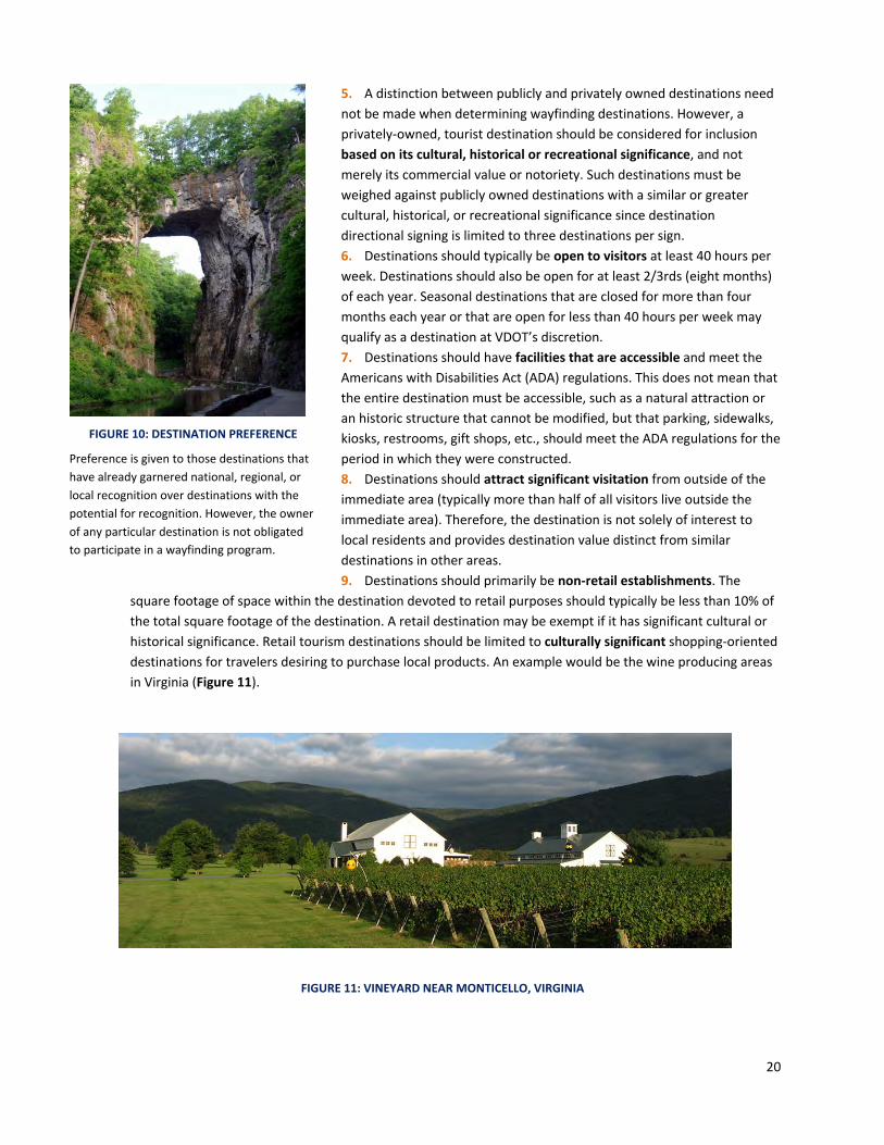
4. A destination with significance that is recognized nationally should be given priority over those of regional and
local recognition. Preference is given to those destinations that have already garnered national, regional, or
local recognition over destinations with the potential for recognition. However, the owner of any particular
destination is not obligated to participate in a wayfinding program (Figure 10).
FIGURE 9: EXAMPLE OF LOCAL DESTINATION
Local destinations, such as community libraries, police
stations and public schools, are generally not eligible
destinations for VDOT’s wayfinding sign program.
20
5. A distinction between publicly and privately owned destinations need
not be made when determining wayfinding destinations. However, a
privately‐owned, tourist destination should be considered for inclusion
based on its cultural, historical or recreational significance, and not
merely its commercial value or notoriety. Such destinations must be
weighed against publicly owned destinations with a similar or greater
cultural, historical, or recreational significance since destination
directional signing is limited to three destinations per sign.
6. Destinations should typically be open to visitors at least 40 hours per
week. Destinations should also be open for at least 2/3rds (eight months)
of each year. Seasonal destinations that are closed for more than four
months each year or that are open for less than 40 hours per week may
qualify as a destination at VDOT’s discretion.
7. Destinations should have facilities that are accessible and meet the
Americans with Disabilities Act (ADA) regulations. This does not mean that
the entire destination must be accessible, such as a natural attraction or
an historic structure that cannot be modified, but that parking, sidewalks,
kiosks, restrooms, gift shops, etc., should meet the ADA regulations for the
period in which they were constructed.
8. Destinations should attract significant visitation from outside of the
immediate area (typically more than half of all visitors live outside the
immediate area). Therefore, the destination is not solely of interest to
local residents and provides destination value distinct from similar
destinations in other areas.
9. Destinations should primarily be non‐retail establishments. The
square footage of space within the destination devoted to retail purposes should typically be less than 10% of
the total square footage of the destination. A retail destination may be exempt if it has significant cultural or
historical significance. Retail tourism destinations should be limited to culturally significant shopping‐oriented
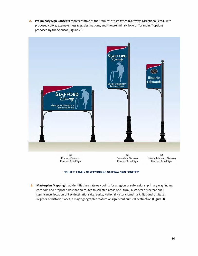
destinations for travelers desiring to purchase local products. An example would be the wine producing areas
in Virginia (Figure 11).
FIGURE 11: VINEYARD NEAR MONTICELLO, VIRGINIA
FIGURE 10: DESTINATION PREFERENCE
Preference is given to those destinations that
have already garnered national, regional, or
local recognition over destinations with the
potential for recognition. However, the owner
of any particular destination is not obligated
to participate in a wayfinding program.

21
10. Destinations should be accessible by adequate roads and access points which accommodate the anticipated
traffic volume and vehicle types, such as RV’s, directed to the destination. For example, a destination that is
accessible via unpaved roads on which only four‐wheel drive vehicles can traverse would not be considered a
suitable destination for a wayfinding sign program.
11. Destinations should have sufficient parking for the anticipated peak traffic directed to the destination during
normal operations. For example, a destination that does not have any off‐street and/or limited on‐street
parking in the immediate vicinity, but is expected to draw hundreds of people per day arriving by vehicle,
would be less than an ideal candidate for being a destination on a wayfinding sign.
3.1.2 List of Acceptable Destinations
Destinations that are generally acceptable to VDOT for inclusion in a wayfinding sign program are listed in Table 1,
Table 2 and Table 3.
TABLE 1: ACCEPTABLE CULTURAL DESTINATIONS
Museums Facilities which exhibit works of artistic, historical, or scientific value to the public.
Colleges and Universities Main campuses or satellite campuses of a degree‐granting educational institution. Individual buildings, points of interest, or parking locations should not be signed outside the main campus.
Centers of Government Town Halls, County Seats and local government complexes
Civic Center Community centers for social and cultural activities.
Culturally Significant Venues for Performing Arts
Facilities could include performing arts centers, amphitheaters, pavilions, arenas, coliseums, and stadiums.
Religious Sites with Cultural or Historic Significance
Buildings or facilities of a religious nature with cultural or historic significance as evidenced by the facility being listed on the Virginia Landmarks Register or National Register of Historic Places, both administered by the Department of Historic Resources (DHR).
Wine, Brewery or Distillery regions Designated Regions of a community with licensed sites for touring and education regarding production processes for wine, beer, spirits or other consumer products.
Culturally Significant Shopping Destinations
Major culturally‐oriented destinations for travelers desiring to purchase local products, including antiques/crafts/local produce and other specialty shops selling the products and wares of local farmers and artisans.
Observatories Facilities for observing astronomical, meteorological, environmental, or other natural phenomena.
State or Regional Library or Archives Facilities housing literary and artistic media for public use and reference for the State of Virginia or information specific to the history and culture of a region.

22
TABLE 2: ACCEPTABLE RECREATIONAL DESTINATIONS
Natural Attractions Naturally occurring attractions of interest, including waterfalls, caverns, caves, natural bridges, and special rock formations.
Parks National, State, Regional, County, and Municipal parks with significant recreational or cultural value.
Scenic Parkways, Overlooks, Vistas and View sheds
Designated public scenic locations with significant recreational or cultural value. Entrances to scenic parkways may be signed if the wayfinding sign program does not include the scenic parkway itself.
Visitor Centers Facilities which provide tourist information and support services.
Trails and Trailheads Designated trails, shared‐use paths, or trailheads with significant recreational or cultural value.
Sports Complexes Complexes having multiple fields or venues where regional, state or national tournaments/competitions are held during multiple times of the year.
Beaches Designated public beaches with recreational or cultural value.
Public Piers and Waterfronts Designated public areas with access or views of water bodies with significant recreational or cultural value.
Natural Resource Destinations Facilities designated for appreciation of natural resources such as wildlife refuges and nature centers.
Public Zoos, Zoological Parks or Gardens, and Aquariums
Public facilities for education, protection, or exhibition of animals.
Arboreta and Botanical Gardens Facilities for education, research and/or exhibition of plants.
Fairgrounds Designated areas for holding fairs and exhibitions.
Historic Hotels or Resorts
Historic Hotels or Resorts with lodging and recreational facilities as evidenced by the facility being listed on the Virginia Landmarks Register or National Register of Historic Places, both administered by the Department of Historic Resources (DHR).

23
TABLE 3: ACCEPTABLE HISTORIC DESTINATIONS
Historic Sites
Structures, collections of structures, sites of a structure now lost to time, or sites listed on the National Register of Historic Places or the Virginia Landmarks Register, both administered by the Virginia Department of Historic Resources.
Historic Districts Districts or zones listed on the National Register of Historic Places or the Virginia Landmarks Register.
Historic Monuments or Memorials Locations commemorating an historic event or persons, including battlefields.
Historical Government Buildings Buildings of historical interest operated by a federal, state, county, or municipal government, including capitol buildings and courthouses.
Heritage Roads, National Scenic Byways and Historic Routes
Designated corridors with significant historic, scenic or cultural value to a region or through multiple regions.
Historic Sites of a Local Interest
Historic Sites that are recognized for their historical significance by the local county but not on the National Register of Historic Places or the State Registry are eligible but should not be given priority over more prominent sites. Approvals for including destinations of “Local Interest” are made at VDOT’s discretion.
3.1.3 List of Unacceptable Destinations
The following destinations listed in Table 4 are generally not acceptable for wayfinding sign programs unless they
have a demonstrated specific Cultural, Recreational, or Historical Significance or meet the requirements indicated.
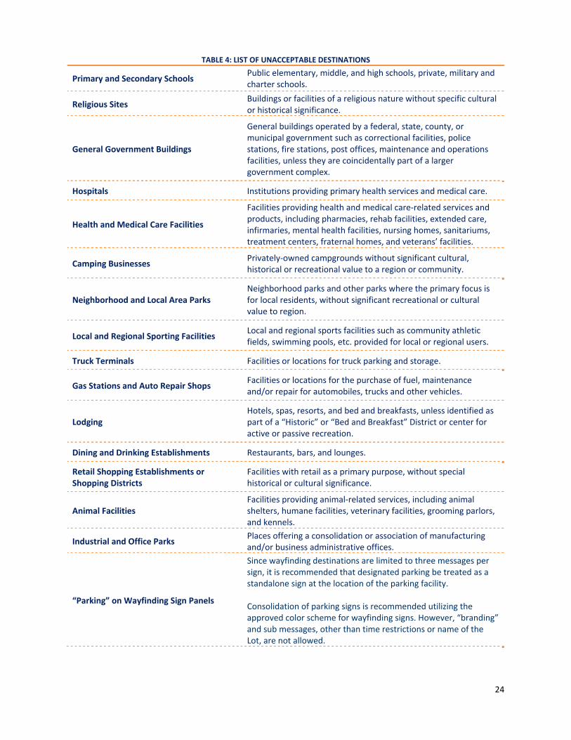
24
TABLE 4: LIST OF UNACCEPTABLE DESTINATIONS
Primary and Secondary Schools Public elementary, middle, and high schools, private, military and charter schools.
Religious Sites Buildings or facilities of a religious nature without specific cultural or historical significance.
General Government Buildings
General buildings operated by a federal, state, county, or municipal government such as correctional facilities, police stations, fire stations, post offices, maintenance and operations facilities, unless they are coincidentally part of a larger government complex.
Hospitals Institutions providing primary health services and medical care.
Health and Medical Care Facilities
Facilities providing health and medical care‐related services and products, including pharmacies, rehab facilities, extended care, infirmaries, mental health facilities, nursing homes, sanitariums, treatment centers, fraternal homes, and veterans’ facilities.
Camping Businesses Privately‐owned campgrounds without significant cultural, historical or recreational value to a region or community.
Neighborhood and Local Area Parks Neighborhood parks and other parks where the primary focus is for local residents, without significant recreational or cultural value to region.
Local and Regional Sporting Facilities Local and regional sports facilities such as community athletic fields, swimming pools, etc. provided for local or regional users.
Truck Terminals Facilities or locations for truck parking and storage.
Gas Stations and Auto Repair Shops Facilities or locations for the purchase of fuel, maintenance and/or repair for automobiles, trucks and other vehicles.
Lodging Hotels, spas, resorts, and bed and breakfasts, unless identified as part of a “Historic” or “Bed and Breakfast” District or center for active or passive recreation.
Dining and Drinking Establishments Restaurants, bars, and lounges.
Retail Shopping Establishments or Shopping Districts
Facilities with retail as a primary purpose, without special historical or cultural significance.
Animal Facilities Facilities providing animal‐related services, including animal shelters, humane facilities, veterinary facilities, grooming parlors, and kennels.
Industrial and Office Parks Places offering a consolidation or association of manufacturing and/or business administrative offices.
“Parking” on Wayfinding Sign Panels
Since wayfinding destinations are limited to three messages per sign, it is recommended that designated parking be treated as a standalone sign at the location of the parking facility. Consolidation of parking signs is recommended utilizing the approved color scheme for wayfinding signs. However, “branding” and sub messages, other than time restrictions or name of the Lot, are not allowed.

25
3.2 Placement and Routing This section is organized into five areas: wayfinding sign types and location, routes to wayfinding destinations, sign
placement, elements of sign design and adjacent wayfinding systems.
3.2.1 Prioritization of Wayfinding Signs
Wayfinding signs, once installed, will take priority over traditional Tourist‐Oriented Directional Signs (TODS) or
Supplemental Guide Signs (SGS) having the same destinations listed in the immediate vicinity. Coordination and
agreement with VDOT, owners of affected destinations and the Statewide IDSP Contractor is the responsibility of
the Sponsor. In such cases, affected TODS and SGS destination messages shall be removed, at the Sponsor’s
expense, by the VDOT IDSP Contractor upon completion of the wayfinding sign project. Existing traditional TODS
that serve as trailblazer signs should also be replaced with signs that conform to the wayfinding sign design. All
TODS and SGS replacements shall be coordinated with the VDOT IDSP Program Manager and clearly indicated on
the plan submittals. SGS signs may remain on limited access or other routes where wayfinding signs do not exist or
are excluded and which act as part of the wayfinding system (Figure 12).
FIGURE 12: EXAMPLE OF A WAYFINDING SIGN SYSTEM
(SOURCE: MUTCD, FIGURE 2D‐18)

26
3.2.2 Wayfinding Sign Types and Location
Wayfinding signs should be located in a manner that assists drivers in determining their current position relative to
a specific destination or multiple destinations. Signs should direct drivers to destinations using the route (or
routes) that best balance safety, distance, and efficiency, unless otherwise approved by VDOT. Exceptions to this
policy may be considered if a specific route to a destination enhances the visitor’s cultural, historical, or
recreational experience over another route; such as a route via a scenic byway in lieu of a multi‐lane roadway. The
signs should be designed and placed in a context‐sensitive manner accounting for the surrounding natural and
man‐made environment, as well as other signing and nearby traffic control devices.
The following paragraphs discuss the sign types associated with a wayfinding program and guidance on locating
each sign type relative to the destinations and other features of the wayfinding system. Figure 13 shows a
schematic diagram for locating sign types in a hypothetical wayfinding system. This diagram may serve as an
example of how to begin mapping out a wayfinding system.
FIGURE 13: SCHEMATIC DIAGRAM OF A COMMUNITY WAYFINDING SIGN SYSTEM

27
1. Gateway Signs are signs used on non‐limited access roadways to welcome the
motorist to a community wayfinding region as well as introducing them to the
branding or logo and color scheme of the signing system for that region
(Figure 14). Gateway signs are typically located at entryways to corridors
providing primary access to key wayfinding destinations. The wayfinding
region may be a jurisdictional boundary, such as a village, town, or county
line, or an undefined boundary such as a non‐independent town. If the
boundary is defined, the signs should be located in the first appropriate
location near the boundary. In order to reduce sign clutter, position signs
approximately two miles apart in a given direction where possible. For an
undefined wayfinding region boundary, signs may instead be placed at a
location generally accepted by drivers as the gateway to a region, such as a
geographically significant mountain or waterway crossing or where the
approaching roadway changes from a rural cross section to
a urban cross section or changes from a non‐divided
highway to a divided highway and so on. While Gateway
signs may be located after exiting a limited access
highway, signs shall not be located within the limited
access right‐of‐way.
2. Sub‐region Gateway Signs are used on non‐limited access roadways at or near the
border of a sub‐region which introduces the motorist to the sub‐region (Figure 15). A sub‐
region is a specific area of a locality or region, such as a town, village or historic district,
with sufficient name recognition to efficiently route visitors to the sub‐region first, and
then to individual destinations. Sub‐region gateway signs are located in relation to
geographic features, jurisdictional boundaries, historic districts or urbanized areas utilizing
the same criteria for gateway signs. Sub‐region gateway
signs shall not be located on limited access roadways.
3. Destination Directional Signs provide directions to a
specific destination or grouped categories of destinations.
These wayfinding signs are located in advance of roadway
intersections in a wayfinding network where drivers are
required to turn to reach a wayfinding corridor, sub‐region,
or destination. A decision point may also include a major
intersection or a location where the predominant flow of
traffic is a turning‐movement and drivers are required to
continue straight through to reach a wayfinding corridor,
sub‐region, or destination.
Destination directional wayfinding signs point drivers to destinations along the
approved route. One destination directional sign may be located at each decision
point (intersection). Only three destinations, displayed with arrows pointing a driver
along the approved route, will be allowed on each destination directional wayfinding
sign” (Figure 16). Occasionally, a destination directional wayfinding sign with
straight‐ahead arrows may be used beyond the intersection while traveling in the
same direction from a complex roadway junction (typically marked by a significant
turning movement with the majority of traffic departing the route) to confirm to drivers that they are on the
correct route to reach their desired destination. However, these designations may only occur within five miles of
the destination and are generally to be avoided if possible. Destination directional signs may include branding to
FIGURE 15: EXAMPLE SUB‐REGION GATEWAY SIGN
FIGURE 16: EXAMPLE DESTINATION DIRECTIONAL SIGN
FIGURE 14: EXAMPLE GATEWAY SIGN

28
identify with the community; however, branding, pictographs or the designation of districts or sub regions within a
region shall occur at the top of the sign per the MUTCD.
4. Wayfinding Corridor Marker – A wayfinding corridor is useful for situations where visitors
can be routed to and along the corridor first, and then to individual destinations along the
corridor. A wayfinding corridor marker, similar to a route marker, is a branded icon,
logo and/or phrase used to designate a specific corridor crossing one or more
jurisdictions from which individual destinations can be reached. Directional arrows
indicating a new route for drivers to follow may be placed as a separate panel below
the Corridor Marker Panel (Figure 17). Corridor markers are generally placed at key
entry points to a designated corridor, prior to and following key decision points to
confirm the new route to the driver, as well as at specified intervals along the corridor
when there are no decision points (no more frequent than one sign for every 1/10th the
length of the Wayfinding Corridor or every 5 miles, whichever is greater). When
designating a “Wayfinding Corridor” it is important to note that signs are required
where the route changes from the current direction of travel and/or exits one route to
another. It should not be assumed that drivers are familiar with a designated
wayfinding route.
3.2.3 Routes to Wayfinding Destinations
A designated wayfinding route is generally the fastest, safest, and most efficient route that
does not involve the use of limited access roadways. The exact nature of the route network
will depend on the number of gateways, the number of destinations, and whether any
wayfinding corridors or sub‐regions are utilized. In the simplest wayfinding systems, with few gateways and
destinations, each destination can be signed on the same route following the gateway sign. In more complex
systems, destinations may be signed from the nearest wayfinding corridor or sub‐region. The following bullets
provide guidance on the selection of wayfinding routes:
1. Local roads, such as residential streets, should not be designated as wayfinding gateways or wayfinding routes
unless unique characteristics of that route, such as a scenic byway or marked geographical feature, make it
desirable to do so, or if it is the only route to a specific destination. Designers may obtain information on the
classification of roadways from VDOT’s Functional Classification Mapping. The proportion of visitors from
outside of the area should be estimated based upon the regional highway network, the expected amount of
through traffic on the roadway, and the function that the roadway serves. Interchanges with limited access
highways may be considered as “gateways” for the purposes of this manual, provided that gateway signs are
not installed on the limited access right‐of‐way. Supplemental guide signs may be utilized for the limited
access route mainline or ramps, as part of the IDSP (See Figure 12, page 24, for illustration).
2. The route from a gateway to a wayfinding destination should follow the hierarchy of the roadway network,
starting with higher volume/higher speed roadways, and working down to lower volume/speed roadways with
greater access to destinations. Wayfinding signs for designating a wayfinding route may begin on a primary
highway (non‐limited access) in proximity to an interstate highway or freeway interchange.
3. When a route from a gateway to a destination passes through a known high‐crash location, the VDOT District
Traffic Engineer will advise the Sponsor as to whether an alternate route is advisable or necessary.
4. Routes should minimize complex turning maneuvers or intersections that visitors unfamiliar with local
roadways may find challenging, to the extent possible.
5. When many destinations are located in readily identifiable areas, such as an urban neighborhood or a town
within a regional wayfinding system, consideration should be given to utilizing a two‐step routing process and
FIGURE 17: EXAMPLE WAYFINDING CORRIDOR
MARKER

29
creating a sub‐region. The two step process would first route drivers to the sub‐region, and then from the sub‐
region’s gateway to individual destinations.
6. In some cases, where there is only one major roadway through a wayfinding region with a gateway at either
end, the roadway becomes a de‐facto wayfinding corridor. Although not formally signed as such, the roadway
will function as a wayfinding corridor by limiting signing for a particular destination to one key location in
advance of where drivers turn off of the roadway.
3.2.4 Sign Placement
Sign placement shall conform to Section 2D.50 of the 2009 MUTCD, VDOT Standards and the guidelines within this
manual for placement of community wayfinding signs (The MUTCD also includes information on the location of
pedestrian wayfinding signs to minimize distraction to drivers.) The following list outlines the major considerations
for placement of wayfinding sign systems:
1. All wayfinding signs shall be installed to the right of the direction of travel and in locations where sufficient
space is available, unless otherwise permitted by VDOT.
2. Wayfinding signs mounted overhead of the roadway on any type of sign structure are not permitted.
3. Signs shall be mounted with the bottom of the sign panel at minimum vertical clearances as follows (See Road
Design Manual, Appendix A, page 129).
‐ 5 feet above the projected edge of pavement elevation in rural areas
‐ 7 feet above the projected top of curb elevation in urban areas (sidewalk)
‐ 8 feet above the pavement elevation of a shared use path at any location
‐ Mounting signs above these clearances shall not be permitted unless approved by the DTE.
4. If located outside the state maintained right‐of‐way, wayfinding signs are subject to state and local outdoor
advertising laws and must be permitted under those programs.
5. Wayfinding signs shall not be installed at the location of the entrances to destinations, unless the entrance is
visually obscured in the direction of travel. Wayfinding signs should be located well in advance of any location
where a turn is required from the highway.
6. Proximity of other intersections on the route, prevailing approach speeds, visibility, location and size of
regulatory, warning and other guide signs, signals, lighting, underground utilities and other context‐sensitive
issues shall be considered in identifying the proper placement of wayfinding signs.
7. Wayfinding signs should be located a minimum of 100’ from other traffic control devices/signs. This spacing
may need to be adjusted in areas where signs or other traffic control devices are congested.
8. The general location of utilities must be considered in the planning stages. Utilities in proximity to proposed
sign locations shall be located and necessary adjustments made, in advance of submitting final plans, field
staking or sign installation.
9. The maximum number of wayfinding signs on each approach to an intersection shall be one. The maximum
number of destinations on one wayfinding sign shall be three.
10. Wayfinding signs should be located to take advantage of natural terrain and to minimize visual impacts on the
scenic environment.
11. Wayfinding signs shall be positioned so drivers have adequate intersection sight distance when entering the
highway from side roads or driveways.
12. When an intersection is redesigned, reconstructed, or replaced, VDOT reserves the right to relocate, eliminate
or require the Sponsor to alter all displaced and affected wayfinding signs in order to best maintain continuity
of the overall highway signing system. All changes to wayfinding signs or routes to destinations as a result of
the reconstruction are subject to approval by VDOT.
13. The location of Billboards must be considered in the planning stages. Visibility of Billboards from the travelled
way shall not be obstructed by Wayfinding Signs from either direction of travel.

30
3.2.5 Elements of Wayfinding Sign Design
Specific information regarding the sign layout, legend, and enhancement markers (branding) can be found in
Section 2D.50 of the 2009 MUTCD (or relevant section of most current MUTCD). General guidance for sign legends
on the various types of wayfinding signs is presented below and is summarized in Figure 18.
1. Gateway Sign and Sub‐Region Gateway Signs – Gateway signs may be a traditional panel and post style sign
or a “monument” style sign constructed of a mix of materials such as wood, stone, brick veneer, metal or
composite materials. Gateway signs are not required to be retro‐reflective, but may be illuminated. Lighting
fixtures may be placed above signs or incorporated in the sign base or placed at ground level. Lighting fixtures
should not limit visibility of traffic control devices and other roadway features.
A. “Monument” style signs must be located outside of the clear zone or in a protected area behind guardrail
or jersey barrier. Attention to scale is necessary to ensure that the sign is visible and legible from the
roadway.
B. The legend comprises the name of the jurisdiction, historic area, region or sub‐region, town, city, or other
name associated with the wayfinding system.
C. The legend may include “Welcome to” or other similar language but may not contain commercial or civic
organization icons or advertising messages.
D. Gateway signs shall be installed with horizontally‐oriented text. Vertically‐oriented text on Gateway signs
is strictly prohibited.
E. The maximum size of a gateway sign panel within the state maintained right‐of‐way shall be 35 square
feet.
F. Gateway signs shall not be combined with destination directional sign messages.
** If space exists and the arrow is located at the bottom of the sign, the arrow length may be set at 2.5 times the arrow height.
FIGURE 18: WAYFINDING SIGN DESIGN SUMMARY

31
2. Wayfinding Corridor Markers and Destination Directional Signs – A wayfinding sign is comprised of a text
legend and border on a colored background, and may include an Enhancement marker or “branding” of a
community or region. The legend, border and branding must provide a clear and sharp contrast to the
background and shall be retro‐reflective (Figure 19).
A. The Legend comprises a maximum of three destinations in the wayfinding sign alongside an arrow
pointing in the direction to the destination.
B. Destinations located in different directions from one another should be separated by a horizontal line in
the same color and width as the border.
C. Each individual destination shall be limited to a maximum of two lines of text. The text shall be limited to the name of the destination, wayfinding corridor, or sub‐region. No additional promotional information shall be allowed on any sign type.
D. The order of destinations as they appear on a directional sign shall be: i. Straight ahead destination ii. Left turn destination iii. Right turn destination
E. An Enhancement Marker or “branding” for a locality may be incorporated into a wayfinding guide sign or be mounted as a separate panel above the guide sign (Figure 19) and should not exceed 1/5 of the entire surface area of the wayfinding sign. Stand‐alone two‐dimensional silhouettes or three‐dimensional objects are not permitted as part of “branding.”
F. Font Specifications: i. For speeds ≤ 25 mph, use Standard Highway Font Series D, 4‐inch uppercase with default lowercase. ii. For speeds > 30 mph, use Standard Highway Font Series D, 6‐inch uppercase with default lowercase. iii. For speeds > 55 mph, VDOT shall review and approve the Font Series size, arrow size and radius on a
case by case basis. iv. In cases where both higher and lower speeds exist within a single wayfinding system, the Sponsor
may opt for using the larger font size throughout. v. Where right‐of‐way or other restrictions apply (visibility, proximity of regulatory signing, utilities, etc.)
or where a condition may exist where reduced speeds are involved (stop condition, roadway
alignment, etc.), sound engineering judgment should be used to determine whether a smaller size
font, resulting in a smaller size panel, is appropriate. VDOT will make the final determination in cases
where a smaller size font is proposed.
vi. Font size and message length together will determine the general size of the sign. G. Arrow size and Location:
FIGURE 19: WAYFINDING SIGNS, SHOWING ARROW PLACEMENT AND ENHANCEMENT MARKERS
(SOURCE: MUTCD FIGURE 2D‐18)

32
i. For 4‐inch uppercase letters: use a 4‐inch height by 6‐inch length arrow ii. For 6‐inch uppercase letters: use a 6‐inch height by 9‐inch length arrow iii. Arrows for larger fonts are reviewed and approved by VDOT on a case‐by‐case basis iv. Locate Arrow to the left of the destination if the direction is to the left or straight ahead v. Locate Arrow to the right of the destination if the direction is to the right
H. All signs shall have a border as follows: i. For 4‐inch uppercase letters: use a 0.8‐inch border ii. For 6‐inch uppercase letters: use a 1‐inch border iii. Larger borders as approved by VDOT with speeds of > 55mph iv. Dividing lines shall be the same width as the border
I. Sign Radii: All sign corners shall have a radius of two (2) inches, minimum. VDOT will review and approve larger radii for use with larger fonts on roadways with speeds of > 55mph.
J. For Corridor Markers, a legend with branding will generally identify a Route at key entry points and intervals along the corridor.
K. With the exception of green, blue and brown, MUTCD reserved colors shall not be used (black, coral, fluorescent pink, fluorescent yellow‐green, light blue, orange, purple, red, white, and yellow) as predominant background colors.
L. At a minimum, retro‐reflective sheeting used on all sign panels shall conform to the VDOT Road and Bridge Specifications, latest edition, for Type III Sheeting.
M. Regional and sub‐regional branding logos (enhancement markers or pictographs) shall conform to the size, design, and style requirements in Section 2D.50 of the MUTCD (or relevant section(s) of most current MUTCD and be approved by VDOT. The logos shall be consistent in appearance with all signs in the wayfinding system.
N. Pictographs, other than branding, shall not be used. O. No abbreviated word forms shall be allowed unless
approved by VDOT or the most current version of the MUTCD (abbreviations are found in Section 1A.15 of the 2009 MUTCD).
P. Wayfinding signs shall be installed with horizontally‐oriented text. Vertically‐oriented text on wayfinding signs is strictly prohibited.
Q. On multi‐lane highways, a supplemental directional message such as “Left Lane” may be utilized in lieu of arrows at the discretion of VDOT. If more than one destination in the same direction exists on a destination directional sign, the order of the destinations shall be in order of proximity, with those that are nearest located above those that are farther away.
R. Wayfinding signs shall not be used to provide direction to primary destinations where such are identified by existing VDOT guide signs, such as SGS or TODS (See Section 3.2.1).
S. Wayfinding signs shall not be used to provide direction to highway routes or streets, except where such are identified as a wayfinding corridor or are a federally designated Scenic Byway, such as “Blue Ridge Parkway” for example.
T. VDOT destination or other guide signs shall have priority over any community wayfinding sign in placement, prominence, and conspicuity (Figure 20). Wayfinding signs shall not duplicate information indicated on VDOT directional signing.
VDOT will review all sign layouts for panel size, color, and construction for the entire system to promote uniformity
and conformance with applicable VDOT and MUTCD standards. Signs must be approved by VDOT prior to use.
FIGURE 20: VDOT DIRECTIONAL SIGNS
Directional signs take priority over wayfinding signs in
identifying primary destinations including their placement,
prominence, and conspicuity.
(Source, Virginia supplement to the MUTCD).

33
3.2.6 Wayfinding Systems Crossing Multiple Jurisdictions In some cases, several communities may band together to form a seamless wayfinding region or an outside entity
at the state or federal level could implement a wayfinding plan that crosses multiple jurisdictions, such as a
wayfinding corridor. In either case, coordination and formal agreements will need to occur between all localities
and/or owners of privately maintained roadways participating in the program with respect to destination names,
routing to destinations as well as branding. Branding for each community or entity that has agreed to participate in
the wayfinding region or corridor must remain consistent within the overall system including the removal of
redundant or conflicting TODS or SGS signing. Multiple branding of wayfinding sign systems crossing one another
shall not be permitted. Formal agreements, signed by representatives of the affected county, jurisdiction or
property owner (as applicable), must be submitted with the VDOT Land Use Permit application.
3.3 Sign Design Specifications
1. Wayfinding Destination Directional Signs ‐ Aluminum sign panels shall conform to the minimum requirements
of the VDOT Road and Bridge Specifications and shall be fabricated with approved MUTCD sheeting colors on
the front and shall be retro‐reflective.
Wayfinding signs shall be mounted on new posts unless otherwise approved by the VDOT DTE on a case by case
basis. Mounting of wayfinding signs on light poles, signal poles or utilities is prohibited.
2. Gateway Monument‐type Signs shall meet structural requirements of the VDOT Road and Bridge Standards as
applicable to the type of sign. Generally, monument‐type signs cannot meet breakaway standards and shall be
located outside of the clear zone or in a protected area behind guardrail or jersey barrier.
3. Sign Structures shall be NCHRP 350 and/or MASH (Manual for Assessing Safety Hardware) compliant (i.e.
breakaway compliant) when inside the errant vehicle clear zone. These criteria do not apply for signs located
outside the clear zone or protected by guardrail or jersey barrier. Specific information on sign structure
materials, fasteners, anchors, foundations can be found in the current VDOT Road and Bridge Specifications
Manual. In addition, sign structure details can be found in the current VDOT Road and Bridge Standards. VDOT
approved ornamental metal poles may be permitted, such as within urban areas or historic districts, to be
consistent with the surrounding streetscape environment.
3.4 Signing and Sealing
If not using a standard VDOT breakaway sign structure, the structural design for signs within the clear zone shall be
submitted with structural calculations for review and approval by VDOT’s Structures and Bridge Division. These
criteria do not apply for signs located outside the clear zone or protected by guardrail or jersey barrier unless the
size of the sign warrants a structural review as determined by the DTE. All structural sign plans shall be signed and
sealed by a Virginia‐licensed Professional Engineer trained in structural design. VDOT will review all sign structure
materials, anchors, and foundations in order to ensure continuity, uniformity, and conformance with applicable
VDOT standards and specifications for wind loading as well as breakaway features.
Wayfinding panel design and associated site plan submittals shall also be signed and sealed by a Virginia Licensed
Professional Engineer or Professional Landscape Architect (as applicable) in accordance with the Code of Virginia.

34
4 CONSTRUCTION
4.1 Permitting The Construction Phase is initiated by obtaining a VDOT Land Use Permit in accordance with Section 2.2.4 above.
The Sponsor submits the VDOT approved Construction Documents to the Area Land Use Engineer (ALUE) in the
local VDOT Residency Permit Office with the Permit Application and Permit Fee. The implementation phase begins
once the Permit is issued. Additional permit requirements as outlined in the Wayfinding Sign Permit document
(LUP‐WSP) may apply depending on the particular scope of project.
The ALUE will contact the Sponsor with any concerns or corrections on the Permit Application.
4.2 Sign Installation Sign Installation by the Sponsor shall be in accordance with the final approved plans as staked, reviewed and
approved by VDOT.
1. The Sponsor may proceed with implementation of the wayfinding sign installation(s) after issuance of the
VDOT Land Use Permit.
2. All activities performed within state maintained right‐of‐way shall be in compliance with the current version of
the Virginia Work Area Protection Manual (WAPM) and all relevant work zone safety requirements.
3. Field Revisions during construction shall be reviewed and approved by the VDOT ALUE and noted on the As‐
Built Plans.
4.3 Develop and Submit As‐built Plans The Sponsor shall notify the Area Land Use Engineer (ALUE) in the local VDOT District or Residency Office once the
sign installation plan phase is complete and certified as correct, at which time the VDOT ALUE will notify the DTE in
order to conduct an independent final inspection of all sign locations. If any corrections are necessary, the VDOT
DTE will notify the ALUE who will, in turn, notify the Sponsor in writing. Any needed corrections in sign placement,
orientation or otherwise shall be made within 90 days of notification. Once all signs are in place and have been
inspected and approved by VDOT, the Sponsor shall develop a set of “As‐Built” plans. The plans shall be similar in
format and convention as the wayfinding sign design plans, with the exception that the locations of the installed
wayfinding signs shall be field verified and annotated on the plans. The as‐built plans must be marked to indicate
any and all field adjustments made during construction. These plans shall have each sheet clearly marked to
indicate “As‐Built Plans” along with the completion date of the project.
In addition to the “As‐Built Plans,” the Sponsor shall provide a map of the wayfinding sign system in PDF format
with all “in place” signs in the correct location and orientation. A Wayfinding Sign Inventory shall also be provided
in an Excel spreadsheet format with GPS‐obtained latitude and (‐) longitude coordinates, installation date,
photographic inventory, route number/name and sign orientation (example, EB for "East Bound"), VDOT District
and VDOT Residency associated with an identification number assigned to each sign structure. Sign structures
should also be identified as either "gateway," "sub‐gateway," "wayfinding directional" or "wayfinding corridor"
signs. This information shall be included in the final “as‐built” plans package, which must be submitted in an
electronic format with form WS‐AB and future updates of the plan. Submit one "As‐Built" package to the local
VDOT Residency and one package to the VDOT WSPA. Sign graphics or photographic examples of wayfinding signs
should be made available on the Sponsor’s Website to familiarize the public with the wayfinding system and to
highlight destinations within the community.

35
4.4 Post‐Construction Assessment Post‐construction assessments by the Sponsor are required at six month and one year intervals for the first year
after the sign installation is complete, and annually thereafter. Results of the Assessment shall be submitted to the
VDOT WSPA and VDOT ALUE for review. These evaluations should inspect sign condition, assess the positive or
negative impacts of the sign system, and recommend modifications to the system, if necessary. VDOT also reserves
the right to conduct their own inspections of the signs and sign system and to request modifications if errors or
deficiencies exist.
Assessments by the Sponsor should include discussion of:
1. Condition of Signs – Deterioration of sheeting or legend, retro‐reflectivity, any damage to the panel or
structure and cause of these issues
2. Safety – Risks posed to drivers, cyclists, or pedestrians with regard to sign location based upon known crashes,
including any in which wayfinding signs were impacted by an errant vehicle.
3. Effectiveness – Determine the change in trips to destinations on wayfinding signs due to closure of the
destination, and any comments received by the public about reaching destinations, confusion with directions,
etc. Make corrections to, or removal of directional signs as necessary.
4. Feedback – Have destinations received any feedback/comments about the signs? Have tourists provided
comments to the Sponsor? Have locals provided feedback about the wayfinding signs?
5. Modifications – Indicate if any modifications to the system are proposed or needed based upon condition of
the signs, safety, effectiveness, feedback and the correctness of destinations, etc. VDOT will also make
recommendations to the Sponsor if deficiencies exist with a particular sign and/or the sign system.
5 MAINTENANCE
Maintenance is the final element of the wayfinding sign program. Once installed, the Sponsor is responsible for
perpetual maintenance of all wayfinding assets located within VDOT maintained right‐of‐way.
5.1 Maintenance Plan The Sponsor shall prepare a formal maintenance plan prior to issuance of a VDOT Land Use Permit for installation
and maintenance of wayfinding signs. The plan becomes a part of the Land Use Permit of Record with the
Department once approved. The Sponsor is responsible for ensuring that wayfinding signs are in satisfactory
condition, and pose no hazard to road users.
If a sign is not in compliance with VDOT standards, whether or not the condition is the fault of the Sponsor, the
Sponsor is required to perform maintenance in order to bring the sign into compliance. Failure to complete the
maintenance within 90 days of being notified by VDOT may result in VDOT personnel removing the non‐compliant
device at the Sponsor’s expense. At the discretion of the Area Land Use Engineer (ALUE), repeated incidences of
removal and replacement of non‐compliant signs by VDOT forces may result in revocation of the Land Use Permit
and removal of the signs from VDOT maintained right‐of‐way.
1. Maintenance Schedule – The maintenance schedule should indicate when regular sign cleaning and
evaluations of the system should be conducted. A regular maintenance program for sign inspection should be
in place to routinely check the following on an annual basis (minimum).
A. Legibility ‐ cleaning of panel and/or site clearing as necessary
B. General condition of panels and posts due to exposure to weather and sunlight, accident or other damage

36
C. Retro‐reflectivity (daytime and nighttime evaluation), cleaning as necessary
D. Panel to post connections secure
E. Foundation bolts secure, torqued to spec.
F. Condition of foundation / Erosion
G. Verify that sign replacements are according to original plans and specifications
H. Accuracy of named destinations (considering destination changes or closures)
I. Vandalism
J. Fading of sign panels may vary depending on exposure to the sun and other factors. At a minimum,
however, budgeting for the maintenance plan should factor in replacement of sign panels beginning at
each 10‐year interval. This may include a phased approach over two to three years beginning with the
most critical destination signs and such phasing should be included in the maintenance plan.
2. Administration/Management – The plan should state which entity or entities are responsible for managing
the maintenance of the wayfinding sign program. Typically, a department of public works or transportation is
assigned this role and is therefore responsible for deciding how and when maintenance is performed on the
sign system. The plan should also designate a specific person or staff members responsible for the
management and maintenance of the wayfinding sign program and shall provide that person’s telephone and
email contact information to VDOT.
3. Funding – The plan should estimate the maintenance cost of the program for short (3 yr.), intermediate (5 yr.),
and long term horizons (10 yr.). The entity or entities responsible for administering and managing the
maintenance of the wayfinding sign program should identify funding sources to cover these costs and a
reserve amount for contingency.
4. Inventory – The plan should include an inventory of all signs in the wayfinding system, including the location
of each sign, sign design and message, structure type, and date of installation. An inventory of any material
stock, such as posts, blank sign panels, and fasteners, is recommended. Update sign inventory as needed.
5.2 Modifications to Existing Wayfinding Sign Program Sponsors should make every effort to retain electronic copies of all submittals to VDOT. In order to make changes
to a wayfinding sign program, the initial plan set shall be resubmitted in electronic format along with electronic
and hard copies of the new or revised drawings for additional trailblazers, etc. New or revised plan sheets where
new signs are to be placed shall also be submitted. The new or revised drawings shall reference any applicable
details on the initial set and include any additional details necessary.
When the engineering plan is approved by VDOT, a permit will be issued to modify the wayfinding signs.
If a wayfinding sign program is approved with phased implementation and all phases have been approved by
VDOT, then a Sponsor may request a permit for installation of a particular phase of their wayfinding sign program.
VDOT may issue the permit, or may require additional field work to be performed if the original approval is more
than two years old. The additional field work is required to account for any changes to utilities or other field
conditions that may impact new wayfinding signs.
37
6 GLOSSARY
Agent The Agent is an individual contact person representing and acting on behalf of the Sponsor, such as a consultant.
Attraction A place of historical, cultural, or recreational significance that is of interest to visitors and may be used as a destination in a wayfinding sign program.
Destination
An attraction or place of historical, cultural, or recreational significance that meets the acceptable criteria for placement on a wayfinding sign. A wayfinding sub‐region or wayfinding corridor may also be listed on a wayfinding sign as a destination. (Additional guidance is presented later in this policy on acceptable and unacceptable types of destinations for wayfinding signs. The Sponsor has the latitude to make final decisions with respect to destinations for their proposed wayfinding signs. While the Sponsor has the ability to select specific destinations, VDOT reserves the right to reject a destination if it is not appropriate or is inconsistent with the general guidance presented in this manual.)
Enhancement Marker or “Branding”
An enhancement marker consists of a shape, color, and/or pictograph that is used as a visual identifier for the community wayfinding guide signing system for an area (Source: MUTCD).
Expressway
A divided highway that has partial control of access. Typically, expressways have limited number of access points and can include both grade‐separated interchanges and at‐grade intersections, although the spacing of at‐grade intersections is frequently long on expressways.
Freeway A divided highway with full control of access. Typically, drivers can only access a freeway via interchange ramps.
Gateway An entry point into a wayfinding region. A gateway typically has a sign welcoming drivers to the wayfinding region and introducing them to the wayfinding system.
General Motorist Service Signs (GMSS)
These signs use symbols or general terms to let motorists know that services such as hospitals, public phones, gas, food, lodging, or camping are nearby.
IDSP (Integrated Directional Signing Program)
A VDOT program for installing Specific Service (logo) Signs, Supplemental Guide Signs (SGS), Tourist‐Oriented Directional Signs (TODS), and General Motorist Service Signs (GMSS) as approved by the Commonwealth Transportation Board (CTB) criteria and approved fee structure...

38
Limited Access Highway or a Limited Access Facility
A road designated by the Commonwealth Transportation Board (CTB) to be especially designed for through traffic, over which abutters have no easement or right of light, air or access to by reason of the fact that their property abuts upon such limited access highway. Limited access highways include freeways with full control of access (i.e., where drivers can enter or exit at limited locations, typically ramps from interchanges), such as interstate highways, and expressways with full or partial control of access. Adjacent properties do not have driveway connections to limited access facilities, and wayfinding signs are not permitted on these facilities.
Logo Symbols that are used as single branding images for businesses and services.
Owner Virginia Department of Transportation (VDOT) and staff (including contracted Consultants and VDOT Contractors).
Pictograph A pictorial representation or icon used to identify a town, village, district or community, or on a smaller scale; a facility open for public use such as a park or picnic area, a boat ramp, fishing pier, overlook, etc.
Specific Travel Service Signing (LOGO)
Logo signs guide motorists to specific gas, food, lodging, camping and attraction locations along Virginia’s interstates and controlled‐access highways.
Sponsor
The submitting jurisdiction, which is typically a County, Town, State Agency, or a U.S. Government agency within the Commonwealth of Virginia, or another entity endorsed by a locality, State Agency, or U.S. Government Agency authorizing the installation and maintenance of wayfinding signs within state maintained right‐of‐way.
Supplemental Guide Signing (SGS)
These signs guide motorists to specific cultural, recreational, historical, governmental, educational, military and other sites of interest.
Supplier The contractor(s) responsible for fabricating and installing the wayfinding signs.
Tourist Oriented Directional Signing (TODS)
A directional guide sign primarily for use by tourists displaying the name of a business, service, or activity facility. TODS signs are of a standard design and color, may display distance information, and may contain the names of retail businesses. (By comparison, wayfinding signs have a unique design and color, and they are restricted from carrying the specific names of retail establishments.)
Traffic Control Device A traffic sign, traffic signal, pavement marking, or other device designed to regulate, warn, or guide drivers along a roadway to a destination.
VDOT Roadway
A roadway owned, operated, and maintained by VDOT. Non‐VDOT roadways include those owned, operated, and maintained by cities, towns, counties, private land owners/developments, and Federal Agencies.
Wayfinding Corridor
A roadway with a unique identity or historical value and high name recognition within a wayfinding region. Wayfinding signs can direct drivers to the wayfinding corridor first, and then to individual destinations along the corridor.
Wayfinding Sign Program VDOT’s Program for administering the review and approval of wayfinding sign systems submitted by Sponsors.

39
Wayfinding Sign System
A system of wayfinding signs coordinated within one or more jurisdictions sharing a common theme or branding that may include gateway, sub‐gateway, destination directional and wayfinding corridor signing. Supplemental Guide Signs may also be coordinated as part of a wayfinding System on limited access roadways.
Wayfinding Region
An area with a unique identity that is the bounds of a Wayfinding Sign Program. A wayfinding region may be a locality (such as a city, town or county), or another geographically significant area with an undefined legal boundary (such as a mountain valley, group of counties, etc.).
Wayfinding Sub‐region An area with a unique identity and high name recognition within a wayfinding region. Wayfinding signs can direct drivers to the wayfinding sub‐region first, and then to individual destinations within the sub‐region.

40
REFERENCES
VDOT’s Integrated Directional Sign Program (IDSP) is a program designated to guide motorists to various essential
services, business, attractions, tourist destinations, and other points of interest. The IDSP provides interested
establishments a single point of contact to apply for signs along state‐maintained highways. More information
regarding VDOT’s IDSP can be found at:
http://www.virginiadot.org/programs/sign‐default.asp.
The Manual on Uniform Traffic Control Devices (MUTCD) defines the standards used by road managers nationwide
to install and maintain traffic control devices on all public streets, highways, bikeways, and private roads open to
public travel. More information regarding the MUTCD can be found at:
http://mutcd.fhwa.dot.gov
The Virginia Supplement to the MUTCD contains the most current standards, guidance, options, and support for
the design, application, and placement of traffic control devices (including signs, signals, and pavement markings)
on roadways in Virginia. More information regarding the Virginia Supplement to the MUTCD can be found at:
http://www.virginiadot.org/business/virginia_mutcd_supplement.asp
Virginia Standard Highway Signs Booklet ‐ contains a library of current signs in use on VDOT maintained roadways,
including sign dimensions and font sizes, spacing and lettering case. More information can be found on VDOT
standard signs at:
http://www.virginiadot.org/business/resources/TED/final_MUTCD/Standard_Highway_Signs_Book.pdf
VDOT Road and Bridge Standards contain the most current standards and support for the design of roadways and
bridges in Virginia. More information regarding VDOT Road and Bridge Standards can be found at:
http://www.virginiadot.org/business/locdes/Standards_TOC.asp
VDOT Road and Bridge Specifications contain the most current specifications that are standard for all contacts
awarded by the Commonwealth Transportation Board or the Commissioner. More information regarding VDOT Road
and Bridge Specifications can be found at:
http://www.virginiadot.org/business/const/spec‐default.asp
Virginia Work Area Protection Manual contains specific requirements for establishing and conducting a safe Work
Zone as may be required for the installation of wayfinding signs.
http://www.virginiadot.org/Business/resources/Wrk_zone/2011_WAPM_Rev_1.pdf

41
APPENDIX
Appendix A: Experimental and Pilot Wayfinding Sign Programs in Virginia Virginia’s experience with wayfinding signs began in 2005 when a group petitioned VDOT to implement a
wayfinding sign program for the Historic Triangle area of Virginia. This area includes Williamsburg, Jamestown, and
Yorktown as well as surrounding areas. The Historic Triangle wayfinding sign program implemented signs on
conventional highways and at selected locations on interstates. The wayfinding signs, which included a branded
“Colonial Williamsburg” in a script font, were approved by both VDOT and the Federal Highway Administration
(FHWA), who granted VDOT permission to implement the wayfinding signs as an experiment in accordance with
the 2003 MUTCD. Implementation was done prior to the development and release of the 2009 MUTCD, which
contains explicit guidance on community wayfinding signs. Consequently, the Historic Triangle wayfinding sign
program does not adhere to all guidance set forth in the 2009 MUTCD.
The Virginia Administrative Code (24VAC30‐551‐70) was modified in 2005 to allow signs for special programs which
include the supplemental signing programs listed below, among others. The administrative code explicitly stated
that specific special programs signing may be installed on any limited access, primary or secondary facility under
the authority of VDOT. However, wayfinding signs shall not be permitted on any limited access facility, which is
consistent with FHWA guidance. VDOT may issue a land use permit to have special program signing installed upon
approval from the State Traffic Engineer. Under the Statutory Authority of §§ 33.2‐210 and 33.2‐1220 of the Code
of Virginia, the following was included about wayfinding signs:
1. Historic Triangle Wayfinding Group, sponsored by the City of Williamsburg and the Counties of James
City and York, may implement a wayfinding system within state maintained rights‐of‐ways as an
experimental program. Continuation of the pilot program shall be subject to regular consultation with
VDOT.
2. Loudoun County may implement a wayfinding system within state maintained rights‐of‐ways as a pilot
program. Continuation of the pilot program shall be subject to regular consultation with VDOT.
3. Journey Through Hallowed Ground (JTHG) wayfinding System.
VDOT received additional requests for wayfinding sign programs that would involve the installation of wayfinding
signs on VDOT roadways. In 2009, the VDOT Traffic Engineering Division (TED) of the Central Office granted
approval to Purcellville (Loudoun County), Stafford County, and Fairfax County to proceed with the development of
wayfinding signs as pilot programs. These pilot projects have been implemented or are still under a phased
implementation and the process has assisted with the development of this policy manual. While these pilot
projects conform to our Preliminary wayfinding guidelines, some criteria in this manual has been updated or
modified based upon evaluations of those systems and “lessons learned.” An assessment of these and future
community wayfinding sign projects will be ongoing as issues arise that cannot be anticipated.

42
Appendix B: Wayfinding Sign Program Forms for Project Development
Attached forms for use throughout the Wayfinding Plan Development process include the
following:
WS‐PI – Wayfinding Sign Program Initiation Form
WS‐CP – Wayfinding Sign Construction Plans
LUP‐WSP – Land Use Permit, Wayfinding Sign Program
WS‐AB – Wayfinding Sign As Built Plans
Permit Request Flowchart for Wayfinding Sign Projects
SEE FORMS BELOW

Page 1 of 1
Project Initiation & Conceptual Design
Submittal Form & Checklist
FORM WS-PI Commonwealth of Virginia Wayfinding Sign Program
Please submit this form with a Letter of Interest and concept plans to: Wayfinding Sign Program Administrator (WSPA), VDOT Central Office Traffic Engineering Division, 1401 East Broad Street, Richmond, VA 23219 SPONSOR INFORMATION: (please print clearly) Please provide information for the submitting jurisdiction, which is a County, City, or Town within the Commonwealth of Virginia, or another entity acting as Agent for the County, City, Town, or a State Agency, or U.S. Government Agency, to implement and maintain the wayfinding sign program.
Please check that which applies: County City Town State Agency U.S. Gov’t. Agency
SPONSOR/JURISDICTION _____________________________________ DATE: __________________________
ADDRESS __________________________________________________________________________________ Applicant / Sponsor Contact Name: _____________________________________________________________________
Title _______________________________________ Phone ___________________ E-mail _________________________
Applicant / Sponsor Agent Name (If Applicable): _________________________________________________________
Address _____________________________________ Phone ___________________ E-Mail ________________________
_____________________________________ PROGRAM INITIATION & CONCEPTUAL DESIGN SUBMITTAL CHECKLIST:
Required Attached Item
Submittal Form and Checklist WS-PI
“Letter of Interest” (See Wayfinding Sign Program Manual for additional information)
Preliminary Website Information
List of destinations with proposed wording, e.g., “Historic,” “Old,” “Village,” etc.
Brief description of each wayfinding destination to be included on wayfinding signs and justification of its cultural, recreational, or historical significance (See Wayfinding Sign Program Manual for additional information)
Conceptual Master Plan and Preliminary Concept exhibits* (See Wayfinding Sign Program Manual for specific requirements)
*Required copies: One (1) hard copy and one (1) digital copy of the plan

Page 1 of 2
Construction Plan
Submittal Form & Checklist
FORM WS-CP % Submittal Commonwealth of Virginia Wayfinding Sign ing Program
Please submit this form with detailed construction plans to: Wayfinding Sign Program Administrator (WSPA), VDOT Central Office Traffic Engineering Division, 1401 East Broad Street, Richmond, VA 23219
CC: VDOT DTE and VDOT ALUE for Concurrence of each submittal.
SPONSOR INFORMATION: (please print clearly) Please provide the following information for the submitting Sponsor, which may be a County, City, Town or State Agency within the Commonwealth of Virginia, a U.S. Government Agency or another entity endorsed by a County, City, Town, State Agency, or U.S. Government Agency:
SPONSOR __________________________________________________ DATE: __________________________
ADDRESS __________________________________________________________________________________
Sponsor Contact Name: ______________________________________________________________________________
Title _______________________________________ Phone ___________________ E-mail _________________________
Sponsor Agent Name (If Applicable): ____________________________________________________________________
Address _____________________________________ Phone ___________________ E-Mail ________________________
CONSTRUCTION PLAN SUBMITTAL CHECKLIST:
Required Attached GENERAL CRITERIA
Submittal Form and Checklist WS-CP
Construction Plan Submittal Requirements *
The Sponsor or their Agent will provide staking of the proposed signs for field inspection by VDOT staff to be performed in conjunction with the plan review and approval process.
A pre-construction meeting shall be held prior to initiating sign installation activities.
Location activities for all privately owned underground utilities shall be completed prior to initiating sign installation activities.
The local VDOT permit office must pre-approve pavement potholing for locating existing underground utilities.
Right-of-way restoration shall be in accordance with current VDOT standards & specifications.
Erosion & sediment control shall be in accordance with current Virginia Erosion & Sediment Control Standards & Specifications.
The installation of signs shall not adversely affect the visibility of roadway users, and the lighting support posts & support post locations shall not compromise VDOT clear zone and safety standards.
Temporary traffic control shall be designed in accordance with the current Virginia Work Area Protection Manual.

Page 2 of 2
The Sponsor or their Agent shall notify the appropriate VDOT Transportation Operations Center (TOC) 30 minutes prior to implementing a lane closure or shoulder closure and within 30 minutes of removing said closure(s).
The Sponsor or their Agent must notify VDOT a minimum of 48 hours prior to initiating any planned excavation within 1,000 feet of a signalized intersection and/or near VDOT ITS infrastructure. Excavation activities may proceed only after VDOT has notified the Sponsor or their Agent that the utility marking has been complete.
VDOT will provide the Sponsor or their Agent with contact information for plan submittal & review, permit issuance & inspection, and the location of underground traffic signal communications facilities.
PLAN SUBMITTAL REQUIREMENTS (Check all that apply for this % submittal - Implementation may begin
following WSPA, DTE and ALUE approval of 100% Plans, approved Field Staking and Preconstruction Meeting).
Typical Detail (as applicable) / General Notes sheet
All plan sheets dated & subsequent revision dates noted
Route numbers & street names
Sponsor name, address, contact person, telephone number & e-mail contact information
Sponsor agent name, address, contact person, telephone number & e-mail contact information (if applicable)
Legend identifying all existing & proposed elements depicted on the plans
Overall network or key map showing the proposed route(s) to each destination, region or sub-region for all proposed sign placement locations
North arrow on all plan sheets
Scaled design details & specifications for sign foundations & posts, sign structure and lighting (if applicable)
Scaled design details & specifications for sign panels including style & format, font, color, size and branding image(s)
Plan sheet(s) showing proposed sign locations, existing physical features at each location, including existing VDOT drainage structures & other state maintained infrastructure.
County & municipal boundary lines shown on all plan sheets (if applicable)
GPS-obtained Longitude & Latitude coordinates at all proposed sign structures
Proposed sign location(s) accurately dimensioned from the edge of pavement or face-of-curb and from the nearest street intersection
Traffic control details & notes for each sign location in accordance with current VDOT standards & specifications (if applicable)
Signed & sealed by a professional engineer or landscape architect licensed in Virginia (Structural Design to be signed and sealed by P.E. Only)
Right-of-way restoration details & notes in accordance with current VDOT standards & specifications
VDOT VDOT will provide comments to the Sponsor/ Applicant and/or their Agent within 45 Days of initial receipt of the construction documents. VDOT will arrange for an engineering “walk through” of “field staking” for proposed sign locations by the Applicant / Sponsor once Final Plans have been reviewed and approved. The Wayfinding Sign Program Manual should be utilized for determining specific design requirements.
*Required copies: Five (5) hard copies and one (1) digital copy of the plans

LAND USE PERMIT
LUP-WSP Wayfinding Sign Program
June 30, 2017
Permittee Agreement for Land Use Permit Issuance
I, an official of the undersigned Sponsor, being a County, City, Town or State Agency within the Commonwealth of Virginia, or agency of the U.S. Government, or another entity endorsed by a County, City, Town, State Agency, or U.S. Government Agency hereby acknowledge that I am fully cognizant of all of the following requirements associated with the issuance of a Virginia Department of Transportation (VDOT) land use permit authorizing the installation and maintenance of wayfinding signs within non-limited access state maintained highway right-of-way. Sponsor Name: ______________________________________ Federal Tax ID No. ___________________
Address: _____________________________________________________________________________________
City: _______________________________________ State: _______ Zip Code: ___________________
Sponsor Contact Name: ________________________________________________________________________
Sponsor Contact Signature: _____________________________________________________________________
Sponsor Contact Title: _________________________________________________________________________
Telephone Number: (_____) _______ - ____________ E-mail Address: _____________________________
VDOT Land Use Permit Required by Law
The General Rules and Regulations of the Commonwealth Transportation Board provide that no work of any nature shall be performed on any real property under the ownership, control, or jurisdiction of VDOT until written permission has been obtained from VDOT. Written permission is granted for the above-referenced activity through the issuance of a land use permit. By issuing a permit, VDOT is giving permission only for whatever rights it has in the right-of-way; the permittee is responsible for obtaining permission from others who may also have an interest in the property. The permittee will be civilly liable to the Commonwealth for expenses and damages incurred by VDOT as a result of violation of any of the rules and regulations of this chapter. Violators shall be guilty of a misdemeanor and, upon conviction, shall be punished as provided for in §33.2-210 of the Code of Virginia.
Application Requirements
Application shall be made for VDOT land use permits through the local district permit office where the activity is to take place. Application forms and general information regarding VDOT land use permitting can be obtained by contacting the central office permit manager or at the following VDOT web site: http://www.virginiadot.org/business/bu-landUsePermits.asp The applicant shall provide a notarized affidavit indicating compliance with the registration and notification requirements outlined in § 2.2-1151.1 of the Code of Virginia.

2
In addition to an executed copy of this document, the following forms may be necessary to make an application: LUP-SB Land Use Permit Surety Bond (if applicable) LUP-LC Land Use Permit Letter of Credit (if applicable) Resolution Locality Resolution (if applicable) LUP-LS Landscape Installation & Maintenance Permittee Agreement (if applicable) LUP-LT Lighting Installation Permittee Agreement (if applicable) Contact Information
A list of counties with their corresponding VDOT district offices and contact information may be obtained on the VDOT web site at: http://www.virginiadot.org/about/districts.asp
Central Office Contacts: R.M. “Rick Burgess (804) 225-4903 Al Bryan (804) 371-6737 Permit Fees
The land use permit application shall include a check in an amount determined by the district administrator’s designee based on the schedule found in 24VAC30-151-710 of the Land Use Permit Regulations. Surety Requirement A performance surety in the amount determined by the district administrator’s designee is required to restore the right-of-way in the event of damage or default. This surety may be in the form of cash, check or surety bond LUP-SB, or LUP-LC irrevocable letter of credit. Cash Surety Refund Applicants owing the Internal Revenue Service or the Commonwealth of Virginia may not receive a refund of the cash guarantee provided for the issuance of a VDOT land use permit unless the amount owed is less than the amount of cash guarantee provided. Applicants providing cash guarantee for the issuance of a VDOT land use permit must provide an executed copy of the Commonwealth of Virginia’s Substitute Form W-9 to receive a refund of the cash guarantee provided for the issuance of a VDOT land use permit. Any of the following provisions that may apply, shall apply: General Requirements 1) Permittee acceptance and use of a Virginia Department of Transportation (VDOT) land use permit is prima
facie evidence that the permittee has read and is fully cognizant of all required permit provisions, applicable traffic control plans and associated construction standards to be employed. All applicants to whom permits are issued shall at all times indemnify and save harmless the Commonwealth Transportation Board, members of the Board, the Commonwealth, and all Commonwealth employees, agents, and officers, from responsibility, damage, or liability arising from the exercise of the privileges granted in such permit to the extent allowed by law including any sums ordered to be paid or expended by VDOT by any governmental entity as a fine, penalty or damages for any violation of any applicable environmental law, or to remediate any hazardous or other material, including illicit discharge into VDOT maintained storm sewer systems.
2) The permittee assumes full responsibility for any and all (downstream flooding, erosion, siltation, etc.)
damages that may occur as a result of the work performed under this permit. Furthermore, the Department will in no way be responsible for any damage to the facility being placed as a result of future maintenance or construction activities performed by the Department.

3
3) The permittee agrees to move, remove, alter, or change any installation that interferes with the ultimate construction of the highway in alignment or grade at no cost to the Department unless otherwise stipulated and agreed to by the Department.
4) The permittee shall immediately correct any situation that may arise as a result of these activities that the district administrator’s designee deems hazardous to the traveling public.
5) Any and all highway signs, right-of-way markers, etc., disturbed as a result of work performed under the auspices of a land use permit shall be accurately reset by the permittee immediately following the work in the vicinity of the disturbed facility. The services of a certified land surveyor with experience in route surveying may be required.
6) It shall be the permittee's responsibility to obtain any and all necessary permits that may be required by any other government agencies, i.e., U.S. Army Corp. of Engineers, Department of Environmental Quality, Department of Conservation and Recreation, etc.
7) A copy of the VDOT land use permit shall be maintained at the work site and made readily available for inspection when requested by authorized VDOT personnel. District administrator’s designee may request the permittee to install on site a project information sign to help the public and VDOT personnel identify activities in the right of way ( see LUP-IS).
8) The permittee shall notify the local district permit office at least 48 hours prior to commencement of any work requiring inspection and/or testing as stipulated in VDOT’s Road and Bridge Standards (current edition) and VDOT’s Road and Bridge Specifications (current edition). Failure to carry out this requirement may result in permit revocation.
9) The permittee or their agent must contact the VDOT Customer Service Center at 1-800-367-7623 a minimum of 48 hours prior to initiating any planned excavation within 1,000 feet of a signalized intersection and/or near VDOT ITS infrastructure. Excavation activities may proceed only after the VDOT regional utility location agent has notified the permittee that the utility marking has been completed. Additional information can be found at: http://www.virginiadot.org/business/resources/IIM/TE-383_Request_for_Marking_VDOT_Utility_Location.pdf Alternately, within all localities in the Northern Virginia Construction District, including the Counties of Arlington, Fairfax, Loudoun & Prince William, the Cities of Alexandria, Fairfax, Falls Church, Manassas and Manassas Park, and the Towns of Clifton, Dumfries, Hamilton, Haymarket, Herndon, Hillsboro, Leesburg, Lovettsville, Middleburg, Occoquan, Purcellville, Quantico, Round Hill and Vienna, and on Interstate 95 in the counties of Stafford, Spotsylvania and Caroline, the permittee may request VDOT regional utility marking at: http://www.vdotutilitymarking.virginia.gov
10) The permittee shall to notify “Miss Utility” (or each operator of an underground utility where no notification center exists) of any planned excavation within state maintained right-of-way. This notification must be provided at least 48 hours (excluding weekends and holidays) in advance of commencing with any planned excavation within state maintained right-of-way. Failure to carry out this requirement may result in permit revocation.
11) It is the duty of the district administrator’s designee to keep all roads maintained in a safe and travelable condition at all times. Therefore, any permit may be denied, revoked or suspended when in the opinion of the district administrator’s designee, the safety, use or maintenance of the highway so requires.
12) The permittee shall at all times give strict attention to the safety and rights of the traveling public, their employees and themselves. VDOT reserves the right to stop work at anytime due to safety problems and/or non-compliance with the terms of the permit. The Department may, at its discretion, complete any of the work covered in the permit or restore the right-of-way to the department’s standards and invoice the

4
permittee for the actual cost of such work. The permittee may be required to move, alter, change or remove from state maintained right-of-way, in a satisfactory manner, any installation made under this permit.
13) All work authorized under the auspices of a VDOT land use permit shall be subject to VDOT’s direction and be in accordance with VDOT’s Road and Bridge Standards (current edition) and VDOT’s Road and Bridge Specifications (current edition).
14) Design changes, specified material changes and/or field changes from the approved plans shall be submitted to the appropriate district administrator’s designee for review and approval prior to proceeding with the proposed changes. This submittal shall include written justification, supplemental documentation and/or engineering calculations that support the requested changes.
15) The permittee shall meet or exceed the existing pavement design and typical section when constructing pavement widening adjacent to an existing state maintained roadway. The proposed pavement design and typical section shall be approved by the district administrator’s designee prior to commencing with any work within state maintained right-of-way. All pavement widening shall be in accordance with VDOT’s Road and Bridge Standard 303.02.
16) Within the limits of a VDOT construction project it is the responsibility of the permit applicant to obtain the contractor's consent in writing prior to permit issuance. Information regarding current and/or planned VDOT construction and maintenance activities can be obtained at: http://www.virginiaroads.org/.
17) Phased implementation of a Wayfinding Signing Program requires the issuance of a separate VDOT land use
permit for each planned phase.
18) The placement of ancillary Wayfinding Signing Program assets within state maintained right-of-way shall not compromise VDOT clear zone and safety standards or minimum VDOT intersection and stopping sight distance requirements.
Design Requirements
1) The Sponsor shall comply with all design guidelines and requirements as outlined in the Wayfinding Signing Program Guidance Manual, the current Land Use Permit Regulations and all requirements specified herein.
2) All sign support systems shall be placed in accordance with minimum VDOT clear zone requirements however consideration may be given for the placement of support structures within the clear zone that are of breakaway or frangible type design or are adequately protected with a positive barrier system at the discretion of the Regional Traffic Engineer.
3) Non-roadway lighting may be located within state maintained right-of-way provided such lighting does not adversely affect the visibility of roadway users, and the lighting support posts and support post locations do not compromise VDOT clear zone and safety standards.
Traffic Control and Safety 1) The permittee shall at all times give strict attention to the safety and rights of the traveling public, their
employees, and contractors. Any permit may be revoked or suspended when in the opinion of the district administrator’s designee, the safety, use or maintenance of the highway so requires.
2) In accordance with the Virginia Department of Transportation (VDOT) Road and Bridge Specification, Special Provision 105.14, all activities performed under the auspices of a VDOT Land Use Permit involving the installation, maintenance and removal of work zone traffic control devices must have an individual on-site who, at a minimum, is accredited by VDOT in Basic Work Zone Traffic Control. The accredited person must have their VDOT Work Zone Traffic Control accreditation card in their possession while on-site.

5
3) The individual accredited in Basic Work Zone Traffic Control is responsible for the placement, maintenance and removal of work zone traffic control devices within the project limits in compliance with the permit requirements and conditions, the approved plans and specifications, the Virginia Work Area Protection Manual, and the Manual of Uniform Traffic Control Devices.
4) A person accredited by VDOT in Intermediate Work Zone Traffic Control must be on-site to provide supervision for adjustment to the approved layout of any standard Typical Traffic Control (TTC) layouts outlined in the Virginia Work Area Protection Manual.
5) All traffic control plans shall be prepared by a person verified by VDOT in Advanced Work Zone Traffic Control.
6) Individuals responsible for implementation of work zone traffic control measures shall provide evidence of their accreditation upon request from VDOT personnel.
7) The permittee shall be exempt from the requirements of Virginia Department of Transportation (VDOT) Road and Bridge Specification, Special Provision 105.14 if the authorized activity is not within the roadway (as defined in 24VAC30-151) of a state maintained highway.
8) Non-compliance with the requirements outlined in VDOT Road and Bridge Specification, Special Provision 105.14 may result in a stop work order and / or permit revocation.
9) All activities that require the disruption (stoppage) of traffic shall utilize VDOT certified flaggers. Flag persons shall be provided in sufficient number and locations as necessary for control and protection of vehicular and pedestrian traffic in accordance with the Virginia Work Area Protection Manual. All flaggers must have their certification card in their possession when performing flagging operations within state maintained right-of-way. Any flag person found not in possession of his/her certification card shall be removed from the flagging site and the district administrator’s designee will suspend all permitted activities.
10) Any VDOT certified flag person found to be performing their duties improperly shall have their certification revoked.
11) All signs shall be in accordance with the current edition of the Manual of Uniform Traffic Control Devices (MUTCD).
12) The permittee shall immediately correct any situation that may arise as a result of these activities that the district administrator’s designee deems hazardous to the traveling public.
13) During authorized activities, the permittee shall furnish all necessary signs, flag persons and other devices to provide for the protection of traffic and workers in accordance with the Virginia Work Area Protection Manual or as directed by the district administrator’s designee.
14) Traffic shall not be blocked or detoured without permission, documented in writing or electronic communication, being granted by the district administrator’s designee.
15) All lane or shoulder closures on highways in the Northern Virginia construction district classified as arterial or collector routes must be authorized, documented in writing or by electronic communication by the VDOT Transportation Operations Center (NRO/TOC).
16) If directed by the district, requests for the implementation of temporary lane closures must be entered into the VDOT Lane Closure Advisory Management System (LCAMS) and VaTraffic a minimum of one (1) week prior to the planned execution of lane closure activities on state maintained highways. The permittee or their contractor(s) may enter their requests directly or provide written requests to the VDOT Regional Operations Center as follows:

6
Lane closure requests in all the counties listed below are within the Northern Region and shall be sent to: [email protected]. Counties: Arlington, Fairfax, Loudoun, Prince William, Spotsylvania, and Stafford
Lane closure requests in all the counties listed below are within the Northwest Region and shall be sent to: [email protected]. Counties: Albemarle, Alleghany, Augusta, Bath, Clarke, Culpeper, Fauquier, Fluvanna, Frederick, Greene, Highland, Louisa, Madison, Orange Page, Rappahannock, Rockbridge, Rockingham, Shenandoah and Warren
Lane closure requests in all the counties listed below are within the Southwest Region and shall be sent to: [email protected]. Counties: Amherst, Appomattox, Bedford, Bland, Botetourt, Buchanan, Buckingham, Campbell, Carroll, Charlotte, Craig, Cumberland, Dickenson, Floyd, Franklin, Giles, Grayson, Halifax, Henry, Lee, Montgomery, Nelson, Patrick, Pittsylvania Prince Edward, Pulaski, Roanoke, Russell, Scott, Smyth, Tazewell, Washington, Wise, and Wythe.
Lane closure requests in all the counties listed below are within the Eastern Region and shall be sent to: [email protected].
Counties: Accomack, Greensville, Isle of Wight, James City, Northampton, Southampton, Surry, Sussex and York
Lane closure requests in all the counties listed below are within the Central Region and shall be sent to: [email protected]
Counties: Amelia, Brunswick, Caroline, Charles City, Chesterfield, Dinwiddie, Essex, Gloucester, Goochland, Hanover, Henrico, King and Queen, King George, King William, Lancaster, Lunenburg, Mathews, Mecklenburg, Middlesex, New Kent, Northumberland, Nottoway, Powhatan, Prince George, Richmond, and Westmoreland
Written requests for implementation of temporary lane closures must be submitted to the appropriate VDOT Regional Operations Center by close of business on the preceding Wednesday for the upcoming week’s planned lane closures. All requests being directly input into LCAMS and VaTraffic must be entered no later than 2:00 pm on the preceding Thursday for the upcoming week’s lane closure activities. Any conflicts with other roadway work must be resolved by close of business on Thursday the week prior to the scheduled lane closure activities with documented resolution sent to the VDOT point of contact provided by the regional traffic operation center LCAMS Administrator. Any requests received after these time limitations will not be approved and the proposed work within VDOT right of way requiring lane closures must be rescheduled.
Lane closure requestors wanting direct access to LCAMS and VaTraffic must complete ITD-35E & ITD-36E forms and return to Ms. Carlene McWhirt at [email protected]. Online training is available for LCAMS and VaTraffic and VDOT can accommodate any additional training needs. Please contact Ms. McWhirt at (571) 350-2078 to schedule training.
VIRGINIA WORK ZONE TRAFFIC CONTROL TRAINING OPTIONS
The following three options are available to receive Work Zone Traffic Control (WZTC) training based on an individual’s job duties and responsibilities as required by the FHWA Final Rule on Work Zone Safety and Mobility and the Virginia Department of Transportation:

7
OPTION 1 – Have someone trained to become a qualified instructor in your company who can then instruct others , utilizing training material provided by VDOT. The following qualifications must be met in order to teach the VDOT Basic, Intermediate, or Advanced WZTC training courses:
• Basic – Be flagger certified either by VDOT or by the American Traffic Safety Services Association
(ATSSA); possess two years of practical experience in Highway Design, Construction, Maintenance, or Traffic Operations; possess two years of documented experience in conducting training courses; and successfully complete the VDOT WZTC Intermediate or Advanced course or complete the ATSSA Virginia Intermediate/Traffic Control Supervisor (TCS) course.
• Intermediate - Be flagger certified either by VDOT or by ATSSA; possess two years of practical
experience in Highway Design, Construction, Maintenance, or Traffic Operations; possess two years of documented experience in conducting training courses; complete and possess the ATSSA Virginia Intermediate/TCS certification.
• Advanced - Be flagger certified either by VDOT or by ATSSA; possess two years of practical experience
in Highway Design, Construction, Maintenance, or Traffic Operations; possess two years of documented experience in conducting training courses; complete and possess the ATSSA Virginia Advanced Traffic Control Design Specialist (TCDS) certification or ATSSA Virginia Intermediate TCS certification.
To become an approved instructor, an application must be completed listing the above qualifications and sent to the chairman of VDOT’s WZST committee at the following location: http://www.virginiadot.org/business/resources/wztc/wztc_inst_app_form.pdf
Once a person has become an approved instructor, training material can be obtained from VDOT using the order form obtained from the following location (requires an approved instructor identification number): http://www.virginiadot.org/business/resources/wztc/WZTC_order_form.pdf
OPTION 2 – Obtain the services of an approved instructor from VDOT’s Approved WZTC Instructor List to teach the course or courses you need for your employees.
The Approved WZTC Instructor’s List can be obtained at the following location: http://www.virginiadot.org/business/resources/wztc/Approved_WZTC_Instructors.pdf
A list of Approved Providers of training can be obtained at the following location: http://www.virginiadot.org/business/resources/wztc/wztc_training_sponsors.pdf
OPTION 3 – Send personnel to classes conducted by approved sources such as ATSSA Virginia or the Virginia Local Technical Assistance Program (LTAP).
Courses by ATSSA Virginia can be found at the following location: http://atssa.com/cs/course_information/courses_by_state?state=56
Courses by the Virginia LTAP can be found at the following location: http://ltap.cts.virginia.edu/2%20Page%20Calendar%20June%20-%20Sept%2009.pdf
Basic WZTC courses by the Virginia Rural Water Association can be found at the following location: http://www.vrwa.org/ (See Training Schedule)
Training by the Virginia Transportation Construction Alliance (VTCA) can be found at the following location: http://vtca.org/

8
Visit the following site for additional information regarding Virginia’s Work Zone Traffic Control training program: http://www.virginiadot.org/business/trafficeng-WZS.asp
Authorized Hours and Days of Work Normal hours for work under the authority of a VDOT land use permit are from 9:00 a.m. to 3:30 p.m. Monday through Friday for all highways classified as arterial or collector. All highways classified as local roads will have unrestricted work hours and days. The district administrator's designee may establish alternate time restrictions in normal working hours for single use permits. The central office permit manager may establish alternate time restrictions in normal working hours for district-wide permits. The classifications for all state maintained highways can be found at the following link: http://www.virginiadot.org/projects/fxn_class/maps.asp Emergency Repair In the event of an emergency situation that requires immediate action to protect persons or property, work may proceed within the right-of-way without authorization from the district administrator’s designee; however, the utility owner must contact the VDOT Emergency Operations Center as soon as reasonably possible but no later than 48 hours after the end of the emergency situation. The utility owner must apply for a separate land use permit from the local district permit office for any emergency work performed on state maintained right-of-way when the following actions are proposed:
Stopping or impeding highway travel in excess of 15 minutes, or,
Accessing facilities within limited access right-of-way, or,
Cutting the highway pavement or shoulders. The district administrator’s designee shall determine the applicable permit fee for emergency repair permits. Holiday Restrictions Permitted non-emergency work will not be allowed on arterial and collector highway classifications from noon on the preceding weekday through the following state observed holidays: New Year's Day, Memorial Day, Independence Day, Labor Day, Thanksgiving Day, and Christmas Day. If the observed holiday falls on a Monday, the permit will not be valid from noon on the preceding Friday through noon on Tuesday. Excavation All excavation within state maintained rights-of-way shall comply with OSHA Technical Manual, Chapter 2, Title Excavation: Hazard Recognition in Trenching and Shoring. A professional engineer shall certify all shoring and/or trench boxes. No excavated material is to be placed or tracked on the pavement without written permission from the District Administrator’s designee. When so authorized, the pavement shall be satisfactorily cleaned by a VDOT approved method. No cleated (track-mounted) equipment is to be used on the pavement without properly protecting the pavement from damage. Trenchless Construction
9
Site specific geotechnical sub-surface investigation reports, compiled in accordance with the provisions of VDOT Materials Division Manual of Instructions, shall be submitted to the district administrator's designee if the following trenchless installation(s) are proposed:
The proposed pipe diameter is 24-inches or greater, and;
The proposed pipe cover is less than 3 times the pipe diameter, and;
The AADT of roadway is greater than 25,000, or;
The proposed pipe diameter is 60-inches or greater, or;
Any situation where there is a significant risk identified. Inspection and Restoration
1) Inspection and testing of all backfill and pavement sections shall be performed in accordance with all applicable sections of VDOT’s Road and Bridge Specifications (current edition).
2) If during or before construction it is deemed necessary for the local district permit office to assign an
inspector to the project, the permittee shall pay the Department an additional inspection fee in an amount that will cover the salary, expense allowance, and mileage allowance for the inspection(s) assigned by the Department for handling work covered by this permit. Said inspection fee shall be paid promptly each month on invoices rendered by the Department.
3) It shall be the decision of the district administrator’s designee whether to assign an inspector to monitor
the placement of all backfill and pavement restoration activities. 4) The absence of a VDOT inspector does not in any way relieve the permittee of their responsibility to
perform the work in accordance with the approved plans, provisions of the attached permit, VDOT’s Road and Bridge Standards (current edition) and VDOT’s Road and Bridge Specifications (current edition).
5) The permittee shall be responsible for any settlement of all backfill or pavement restoration necessitated
by authorized excavation activities for a period of two (2) years after the completion date of permit, and for the continuing maintenance of the facilities placed within the highway right-of-way. A one (1) year restoration warranty period may be considered, provided the permittee adheres to the following criteria:
The permittee retains the services of a professional engineer (or certified technician under the direction of the professional engineer) to observe the placement of all backfill and pavement restoration.
The professional engineer (or certified technician under the direction of the professional engineer) performs any required inspection and testing in accordance with all applicable sections of VDOT's Road and Bridge Specifications.
The professional engineer submits all testing reports for review and approval, and provides written certification that all restoration procedures have been completed in accordance with all applicable sections of VDOT's Road and Bridge Specifications prior to completion of the work authorized by the permit.
6) Whenever existing pavement is permitted to be cut, not over one-half of the roadway width shall be
disturbed at one time and the first open cut trench section shall be satisfactorily restored to allow for the passage of traffic prior to the second half of the roadway surface can be disturbed.
7) All crossing of existing pavement shall be bored, pushed or jacked an appropriate distance from the edge-
of-pavement so as not to impede the normal flow of traffic or damage the existing pavement section. Existing pavement shall not be cut unless approved by the district administrator’s designee and then only if justifiable circumstances prevail or proof is shown that a thorough attempt has been made to push, bore or jack.

10
8) Authorized daily trench excavation within pavement sections shall not exceed 500 feet in length.
9) Pavement restoration shall be in accordance with the VDOT LUP-OC Pavement Open Cut Special
Provisions. This document can also be found at: http://www.virginiadot.org/business/bu-landUsePermits.asp
10) Where the pavement is disturbed or deemed weakened in its entirety or such portions as deemed
desirable by the Department, the pavement shall be restored or replaced in a manner that is satisfactory to the district administrator’s designee.
Environmental
1) In accordance with the Virginia Department of Transportation (VDOT) Road and Bridge Specification §107.16, all contractors performing regulated land disturbing activities within VDOT right-of-way must have at least one (1) employee that has successfully completed the VDOT Erosion & Sediment Control Contractor Certification training. This person shall be on site during all land disturbance activities and will be responsible for insuring compliance with all applicable local, state and federal erosion and sediment control regulations during land disturbance activities. This person must have their certification card with them while on the project site. The land use permit will be suspended if proof of certification cannot be provided. Regulated land disturbing activities are defined as those activities that disturb 2,500 square feet or greater in Tidewater, Virginia or 10,000 square feet or greater in all other areas of the State. The Department will require evidence of this certification with any land use permit application that involves utility and/or commercial right of way improvement. Improper installation, maintenance and removal of erosion and sediment control devices may result in revocation of VDOT Erosion & Sediment Control Contractor Certification.
NOTE: Training for the VDOT Erosion & Sediment Control Contractor Certification can be obtained from any of the sources listed under “Upcoming Courses” at: http://www.virginiadot.org/business/locdes/ms4_stormwater_management.asp
2) The permittee is responsible for pursuing and obtaining any and all environmental permits which may be
required to pursue the proposed activity prior to any work beginning within state maintained right-of-way.
3) In the event hazardous materials or underground storage tanks are encountered within state maintained
right-of-way during authorized activities, the permittee shall suspend all work immediately then notify the local district permit office and other responsible parties, i.e., the local fire department, emergency services, Department of Environmental Quality, etc. The permittee is responsible for coordination and completion of all required remediation necessary to complete the permitted activities within the state maintained right-of-way. The permittee shall provide evidence of such compliance to the local district permit office prior to recommencement of permitted activities.
4) In the event cultural resources, archaeological, paleontological, and/or rare minerals are encountered
within the right of way during authorized activities, the permittee shall suspend all work immediately then notify the local district permit office and the proper state authority charged with the responsibility for investigation and evaluation of such finds. The permittee will meet all necessary requirements for resolving any conflicts prior to continuing with the proposed activities within the state maintained right-of-way, and shall provide evidence of such compliance to the local district permit office.
5) Roadway drainage shall not be blocked or diverted. The shoulders, ditches, roadside, drainage facilities
and pavement shall be kept in an operable condition satisfactory to the Department. Necessary precautions shall be taken by the permittee to insure against siltation of adjacent properties, streams,

11
etc., in accordance with VDOT's current standards or as prescribed by the Department’s Environmental Manual and the district administrator’s designee.
Entrances
1) VDOT's authority to regulate highway entrances is provided in §, §33.2-240, and §33.2-241 of the Code of Virginia and its authority to make regulations concerning the use of highways generally is provided in §33.2-210 of the Code of Virginia. Regulations regarding entrances are set forth in VDOT's regulations promulgated pursuant to §33.2-245 of the Code of Virginia.
2) The permittee shall be responsible for the design and installation of a private entrance under the auspices
of a VDOT land use permit however the permittee may request that VDOT forces install the private entrance at the permittee’s expense.
3) Street connections, private entrances, and construction entrances shall be kept in satisfactory condition
during all activities authorized under the auspices of a VDOT land use permit. Entrances shall not be blocked. Ample provisions must be made to provide safe ingress and egress to adjacent properties at all times. Entrances that are disturbed shall be restored to the satisfaction of the property owner and the district administrator’s designee.
Utilities 1) Prior to any excavation, the permittee shall comply with the terms of Title 56, Chapter 10.3 of the
Underground Utility Damage Prevention Act and §56-265.14 through §56-265.20 of the Code of Virginia. This permit does not grant permission to grade on or near property of others, or, adjust or disturb in anyway existing utility poles or underground facilities within the permitted area. Permission to do so must be obtained from the impacted utility company and any expense involved shall be borne by the permittee. Any conflicts with existing utility facilities must be resolved between the permittee and the utility owner(s) involved.
2) All underground utility installations within limited access right-of-way shall have a minimum of 36 inches of cover. All underground utilities within non-limited access right-of-way will require a minimum of 36 inches of cover, except underground cables that provide telecommunications service shall be at a minimum of 30 inches of cover.
3) Where feasible, all aboveground installations (such as fire hydrants, telephone pedestals, markers, etc.) shall
be located adjacent to the outside edge of the right-of-way line and in accordance with minimum clear zone requirements. All manhole covers, valve box, etc., shall be installed two inches below existing ground line and shall conform to existing contours.
4) No poles, guys, anchors, etc., are to be placed on state maintained right-of-way unless authorized under the auspices of a VDOT land use permit. At no time will any such facilities be allowed between the ditch line and the traveled roadway.
5) All overhead installations crossing non-limited access highways shall provide a minimum of 18 feet of vertical clearance or at a minimum height as established by the National Electric Safety Code, whichever is greater. All overhead utility installations within limited access right-of-way shall maintain a minimum of 21 feet of vertical clearance. The vertical clearance for all new overhead parallel installations within non-limited access rights-of-way shall be in compliance with standards as specified in the National Electric Safety Code.
Final Inspection and Completion of Permit
Upon completion of the sign installation(s), the permittee shall provide notification, documented in writing or electronic communication, to the district administrator's designee requesting final inspection. This request shall
12
include the permit number, county name, route number, and name of the permittee. The district administrator's designee will promptly schedule an independent final inspection of all sign locations and advise the permittee in writing of any necessary corrections in sign placement, orientation or otherwise
Upon completion of all final inspections and implementation of any required field adjustments the permittee shall provide VDOT with As-Built plans. Permit Revocation At the discretion of the district administrator’s designee, a land use permit may be revoked upon written finding that the permittee was not in compliance with all requirements contained herein and/or violated the terms of the permit, or any state and local laws and ordinances regulating activities within the right-of-way. In addition VDOT may apply additional penalties in accordance with §33.2-1221. Maintenance
The permittee is responsible for the perpetual maintenance of any and all Wayfinding signs, sign structures and related assets of an authorized Wayfinding Sign Program installed within state maintained right-of-way under the auspices of a VDOT land use permit.
The permittee is responsible for identifying the projected lifetime of wayfinding signs and structures, as supported by manufacturers’ documentation, and performing all necessary maintenance and/or replacement thereof.
The permittee is responsible for developing a maintenance schedule for sign face cleaning, other routine maintenance including when overall system inspections and evaluations should occur.
The permittee is responsible for maintaining an inventory of all wayfinding signs, including the location of each sign, the sign design, message and structure type.
The permittee shall notify the local district permit office by telephone or electronic communication a minimum of 48 hours prior to performing any maintenance activities at Wayfinding sign locations. Failure to provide this information may result in the suspension or revocation of the VDOT Land Use Permit authorizing said activities. A copy of the VDOT land use permit shall be maintained at every Wayfinding sign location when performing maintenance activities and made readily available for inspection when requested by authorized VDOT personnel. Program Modifications
The permittee shall provide VDOT with revised construction documents depicting the proposed changes to a previously approved Wayfinding Sign Program for review and approval prior to implementation.
A separate VDOT land use permit must be issued prior to implementation of authorized modifications to a previously approved Wayfinding Sign Program. Permittee Notice The preceding provisions are intentionally condensed in format and should not be loosely interpreted by the permittee without consultation with the central office permit manager and affirmation from the Land Use Permit Regulations.

Page 1 of 1
As-Built Plans Submittal Form & Checklist
FORM WS-AB Commonwealth of Virginia Wayfinding Sign Program
Please submit this form with the As-Built plans to: Wayfinding Sign Program Administrator (WSPA), VDOT Central Office Traffic Engineering Division, 1401 East Broad Street, Richmond, VA 23219 SPONSOR INFORMATION: (please print clearly) Please provide information for the submitting jurisdiction, which is a County, City, or Town within the Commonwealth of Virginia, or another entity designated as Agent for the County, City, Town, or a State Agency, or U.S. Government Agency, to implement and maintain the wayfinding sign program.
Please check that which applies: County City Town State Agency U.S. Gov’t. Agency
SPONSOR/JURISDICTION _________________________________ COMPLETION DATE: ___________________
ADDRESS ___________________________________________________________________________________
Applicant /Sponsor Contact Name: ________________________________________________
Title _______________________________________ Phone ___________________ E-mail _________________________
Applicant / Sponsor Agent Name (If Applicable): _______________________________________________________
Address _____________________________________ Phone ___________________ E-Mail _______________________
_________________________________
AS-BUILT INFORMATION: (please print clearly) Please fill out and answer the following prompts and questions. Upon completion of the sign installation(s), the sponsor shall provide notification, documented in writing or electronic communication, to the district administrator's designee requesting final inspection. This request shall include the permit number, county name, route number(s), and name of the permittee. The district administrator's designee will promptly schedule an independent final inspection of all sign locations and advise the sponsor in writing of any necessary corrections in sign placement, orientation or otherwise. Upon completion of all inspections, any required field adjustments and permit close-out the sponsor shall develop a set of As-Built plans for submittal to VDOT. AS-BUILT PLAN SUBMITTAL CHECKLIST:
Required Attached Item
Submittal Form and Checklist WS-AB
As-Built Plans
Map showing final sign locations for each sign type including sign legends
Photographic inventory of signs
GIS database or spreadsheet with GPS latitude and longitude coordinates for all final sign locations
*Required copies: Two (2) hard copies and one (1) digital copy of the As-Built plan

LAND USE PERMIT
APPENDIX 30
Permit Request Flowchart for Wayfinding Sign Projects
NOTES: * Participants shall include an Applicant / Sponsor representative and their agents(s), the VDOT Wayfinding Sign Program Administrator (WSPA) or their representative(s), the VDOT District Area Land Use Engineer (ALUE) or their representative, a representative from VDOT regional Traffic Engineering (TE) and all other appropriate VDOT staff.
## This process may include several phased submittals depending on the complexity of the project as determined by the WSPA and Regional Traffic Engineer (TE). Prior to permit close-out the Applicant / Sponsor must provide the WSPM with As-built information on Form WS-AB.
WSPA routes preliminary submittal package to appropriate VDOT staff for review & comment
All Wayfinding Sign Project (WSP) inquiries are to be forwarded to the Wayfinding Sign Program Administrator (WSPA) in the Central Office Traffic Engineering Division
Inquiry must include a Letter of Interest, Form WS-PI & Preliminary Wayfinding Concepts
Plans Approved as submitted: NO
VDOT Approval: YES
WSPA routes construction documents to all appropriate VDOT staff for comprehensive review & comment
Applicant / Sponsor addresses review comments and routes Revised Wayfinding Concepts to WSPA
WSPA compiles meeting notes / comments and returns to Applicant / Sponsor within 30 days of meeting
Applicant / Sponsor develops construction documents and routes to WSPA for review and comment (Form WS-CP) ##
WSPA schedules introductory “Kick Off” meeting with all interested stakeholders* to review comments on Revised Wayfinding Concepts, general program requirements, specific details of the request & any VDOT concerns
Applicant / Sponsor provides Area Land Use Engineer (ALUE) with Form LUP-WSP, permit
application fee, permit surety & associated required documents and plans
VDOT staff route preliminary review comments to WSPA / WSPA transmits review comments to Applicant / Sponsor
Plans Approved as submitted: YES
WSPA routes revised concepts package to appropriate VDOT staff for review & comment
WSPA compiles comments and routes to Applicant / Sponsor to incorporate into Final Construction Documents
VDOT Approval: NO
Preconstruction Meeting with Applicant / Sponsor
WSPA transmits comments to Applicant / Sponsor
VDOT staff route review comment(s) or approval(s) to WSPA
Applicant / Sponsor addresses review comments & routes revised construction documents to WSPA
WSPA routes revised construction documents to appropriate VDOT staff for review & approval
Field adjustments for Staking made per DTE Recommendations
Applicant / Sponsor provides Area Land Use Engineer (ALUE) with Form LUP-WSP, permit
application fee, permit surety & associated required documents and plans
Land Use Permit issuance by ALUE
Applicant / Sponsor provides field staking for all proposed sign locations based on Final Construction
Documents and notifies WSPA and DTE / DTE schedules Engineering “Walk Through” of
proposed sign locations with Applicant / Sponsor & all appropriate VDOT staff
CONSTRUCTION