Embed Size (px)
Citation preview
Special points of interest: Will South Texas experience a
long–term drought again?
Find out more!
Ready for the summer to be
over? Beat the heat with our
safety tips!
Learn more about our new
forecasting tools, and
improvements to the NOAA
Weather Radio System.
Come join us for our Open
House, read in for more
details!
Inside this issue:
Severe Weather 2016 1-3
El Niño or La Niña? 4-5
Beat the Heat! 6-7
MRMS FLASH 8-9
NWR & BMH 10-11
Events & Outreach 12-13
Staff Spotlight 14
Announcements 15
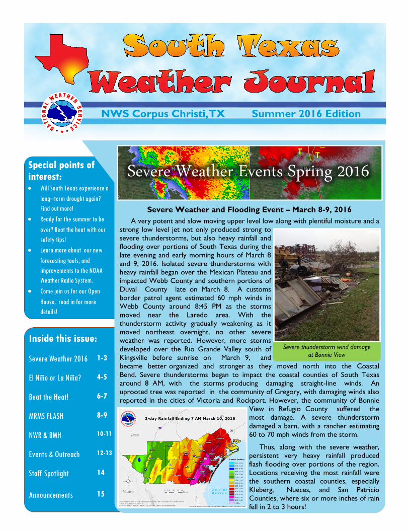
Severe Weather and Flooding Event – March 8-9, 2016
A very potent and slow moving upper level low along with plentiful moisture and a
strong low level jet not only produced strong to
severe thunderstorms, but also heavy rainfall and
flooding over portions of South Texas during the
late evening and early morning hours of March 8
and 9, 2016. Isolated severe thunderstorms with
heavy rainfall began over the Mexican Plateau and
impacted Webb County and southern portions of
Duval County late on March 8. A customs
border patrol agent estimated 60 mph winds in
Webb County around 8:45 PM as the storms
moved near the Laredo area. With the
thunderstorm activity gradually weakening as it
moved northeast overnight, no other severe
weather was reported. However, more storms
developed over the Rio Grande Valley south of
Kingsville before sunrise on March 9, and
became better organized and stronger as they moved north into the Coastal
Bend. Severe thunderstorms began to impact the coastal counties of South Texas
around 8 AM, with the storms producing damaging straight-line winds. An
uprooted tree was reported in the community of Gregory, with damaging winds also
reported in the cities of Victoria and Rockport. However, the community of Bonnie
View in Refugio County suffered the
most damage. A severe thunderstorm
damaged a barn, with a rancher estimating
60 to 70 mph winds from the storm.
Thus, along with the severe weather,
persistent very heavy rainfall produced
flash flooding over portions of the region.
Locations receiving the most rainfall were
the southern coastal counties, especially
Kleberg, Nueces, and San Patricio
Counties, where six or more inches of rain
fell in 2 to 3 hours!
NWS Corpus Christi, TX Summer 2016 Edition
Severe Weather Events Spring 2016
Severe thunderstorm wind damage
at Bonnie View
Page 2 SOUTH TEXAS WEATHER JOURNAL
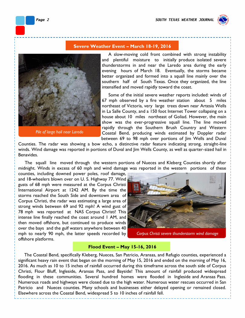
Severe Weather Event – March 18-19, 2016
A slow-moving cold front combined with strong instability
and plentiful moisture to initially produce isolated severe
thunderstorms in and near the Laredo area during the early
evening hours of March 18. Eventually, the storms became
better organized and formed into a squall line mainly over the
southern half of South Texas. Once they organized, the line
intensified and moved rapidly toward the coast.
Some of the initial severe weather reports included: winds of
67 mph observed by a fire weather station about 5 miles
northeast of Victoria, very large trees down near Artesia Wells
in La Salle County, and a 150 foot Internet Tower collapsing on a
house about 10 miles northeast of Goliad. However, the main
show was the ever-progressive squall line. The line moved
rapidly through the Southern Brush Country and Western
Coastal Bend, producing winds estimated by Doppler radar
between 69 to 98 mph over portions of Jim Wells and Duval
Counties. The radar was showing a bow echo, a distinctive radar feature indicating strong, straight-line
winds. Wind damage was reported in portions of Duval and Jim Wells County, as well as quarter-sized hail in
Benavides.
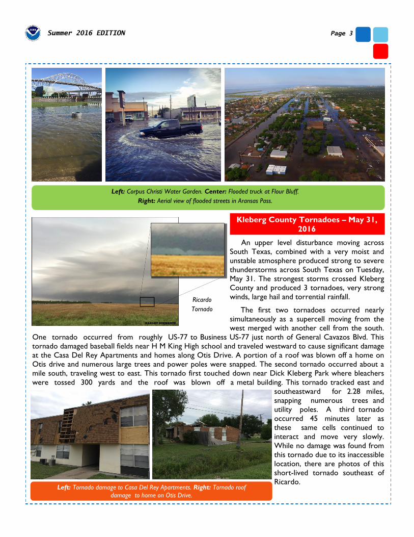
The squall line moved through the western portions of Nueces and Kleberg Counties shortly after
midnight. Winds in excess of 60 mph and wind damage was reported in the western portions of these
counties, including downed power poles, roof damage,
and 18-wheelers blown over on U. S. Highway 77. Wind
gusts of 68 mph were measured at the Corpus Christi
International Airport at 1242 AM. By the time the
storms reached the South Side and downtown area of
Corpus Christi, the radar was estimating a large area of
strong winds between 69 and 92 mph! A wind gust of
78 mph was reported at NAS Corpus Christi! This
intense line finally reached the coast around 1 AM, and
then moved offshore, but continued to produce winds
over the bays and the gulf waters anywhere between 40
mph to nearly 90 mph, the latter speeds recorded by
offshore platforms.
Flood Event – May 15-16, 2016
The Coastal Bend, specifically Kleberg, Nueces, San Patricio, Aransas, and Refugio counties, experienced a
significant heavy rain event that began on the morning of May 15, 2016 and ended on the morning of May 16,
2016. As much as 10 to 15 inches of rainfall occurred during this timeframe across the south side of Corpus
Christi, Flour Bluff, Ingleside, Aransas Pass, and Bayside! This amount of rainfall produced widespread
flooding in these communities. Several hundred homes were flooded in Ingleside and Aransas Pass.
Numerous roads and highways were closed due to the high water. Numerous water rescues occurred in San
Patricio and Nueces counties. Many schools and businesses either delayed opening or remained closed.
Elsewhere across the Coastal Bend, widespread 5 to 10 inches of rainfall fell.
Pile of large hail near Laredo
Corpus Christi severe thunderstorm wind damage
Page 3 Summer 2016 EDITION
Kleberg County Tornadoes – May 31,
2016
An upper level disturbance moving across
South Texas, combined with a very moist and
unstable atmosphere produced strong to severe
thunderstorms across South Texas on Tuesday,
May 31. The strongest storms crossed Kleberg
County and produced 3 tornadoes, very strong
winds, large hail and torrential rainfall.
The first two tornadoes occurred nearly
simultaneously as a supercell moving from the
west merged with another cell from the south.
One tornado occurred from roughly US-77 to Business US-77 just north of General Cavazos Blvd. This
tornado damaged baseball fields near H M King High school and traveled westward to cause significant damage
at the Casa Del Rey Apartments and homes along Otis Drive. A portion of a roof was blown off a home on
Otis drive and numerous large trees and power poles were snapped. The second tornado occurred about a
mile south, traveling west to east. This tornado first touched down near Dick Kleberg Park where bleachers
were tossed 300 yards and the roof was blown off a metal building. This tornado tracked east and
southeastward for 2.28 miles,
snapping numerous trees and
utility poles. A third tornado
occurred 45 minutes later as
these same cells continued to
interact and move very slowly.
While no damage was found from
this tornado due to its inaccessible
location, there are photos of this
short-lived tornado southeast of
Ricardo.
Left: Corpus Christi Water Garden. Center: Flooded truck at Flour Bluff.
Right: Aerial view of flooded streets in Aransas Pass.
Left: Tornado damage to Casa Del Rey Apartments. Right: Tornado roof
damage to home on Otis Drive.
Ricardo
Tornado
fect: Will El
Page 4 SOUTH TEXAS WEATHER JOURNAL
From El-Niño to La-Niña? Will South Texas
Experience a Long-Term Drought Again?
Greg Wilk—Senior Forecaster
A LOOK FORWARD
El-Niño conditions (above normal sea surface temperatures over the Equatorial Pacific) persisted over
the Equatorial Pacific from the early part of 2015 through the first half of 2016. As of late June 2016, sea
-surface temperatures in the El-Niño region have transitioned from being above normal to becoming
slightly below normal. Model forecasts indicate that sea surface temperatures (SSTs) are likely to become
even more below normal through the end of the year, resulting in La Niña conditions. Because of this
transition, the El-Niño Advisory which was in effect since March 2015 has ended, and has been replaced by
a La-Niña Watch. According to the Climate Prediction Center (CPC), La Niña is favored to develop
during the August through October 2016 period, with a 55% to 60% chance of La Niña occurring during
the fall and winter of 2016-2017.
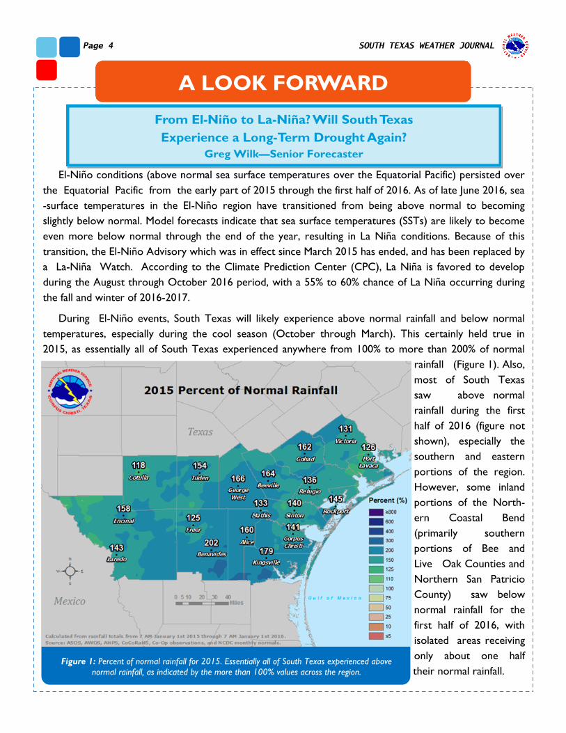
During El-Niño events, South Texas will likely experience above normal rainfall and below normal
temperatures, especially during the cool season (October through March). This certainly held true in
2015, as essentially all of South Texas experienced anywhere from 100% to more than 200% of normal
rainfall (Figure 1). Also,
most of South Texas
saw above normal
rainfall during the first
half of 2016 (figure not
shown), especially the
southern and eastern
portions of the region.
However, some inland
portions of the North-
ern Coastal Bend
(primarily southern
portions of Bee and
Live Oak Counties and
Northern San Patricio
County) saw below
normal rainfall for the
first half of 2016, with
isolated areas receiving
only about one half
their normal rainfall. Figure 1: Percent of normal rainfall for 2015. Essentially all of South Texas experienced above
normal rainfall, as indicated by the more than 100% values across the region.
fect: Will El-Niño Oc-
Page 5 Summer 2016 EDITION
Drier conditions began to return to all of South Texas during the last half of June, as El-Niño ended and
more neutral conditions developed over the region. Some beneficial rainfall late in July over the northern
and western portions of South Texas helped to alleviate some of the drier conditions over the last several
weeks, but overall the weather pattern became warmer and drier. By the end of July, portions of Live Oak,
Bee, San Patricio, and Western Webb Counties were experiencing moderate drought conditions.
During La Niña events, South Texas is usually drier and warmer than normal, especially during the
cooler months (i.e., the opposite from El-Niño). So, given the potential for a La Niña event to develop, will
South Texas experience a return to drought conditions? If La Niña develops by the end of 2016, then we
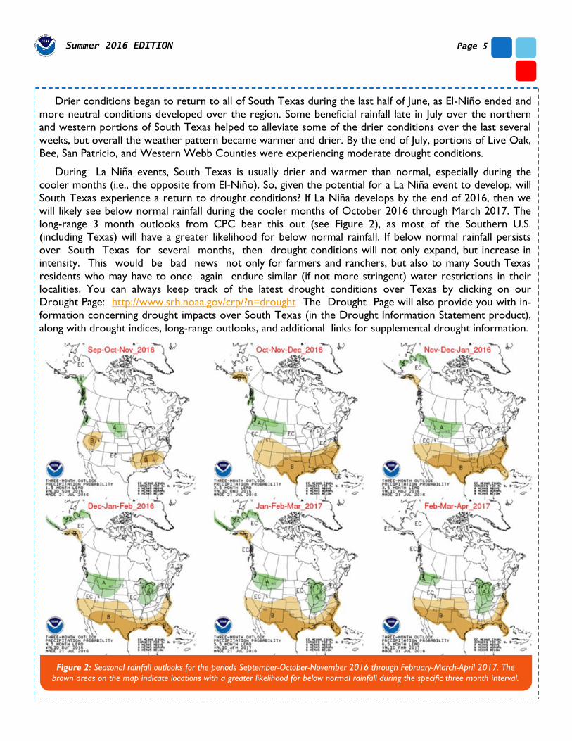
will likely see below normal rainfall during the cooler months of October 2016 through March 2017. The
long-range 3 month outlooks from CPC bear this out (see Figure 2), as most of the Southern U.S.
(including Texas) will have a greater likelihood for below normal rainfall. If below normal rainfall persists
over South Texas for several months, then drought conditions will not only expand, but increase in
intensity. This would be bad news not only for farmers and ranchers, but also to many South Texas
residents who may have to once again endure similar (if not more stringent) water restrictions in their
localities. You can always keep track of the latest drought conditions over Texas by clicking on our Drought Page: http://www.srh.noaa.gov/crp/?n=drought The Drought Page will also provide you with in-
formation concerning drought impacts over South Texas (in the Drought Information Statement product),
along with drought indices, long-range outlooks, and additional links for supplemental drought information.
Figure 2: Seasonal rainfall outlooks for the periods September-October-November 2016 through February-March-April 2017. The
brown areas on the map indicate locations with a greater likelihood for below normal rainfall during the specific three month interval.
Page 6 SOUTH TEXAS WEATHER JOURNAL
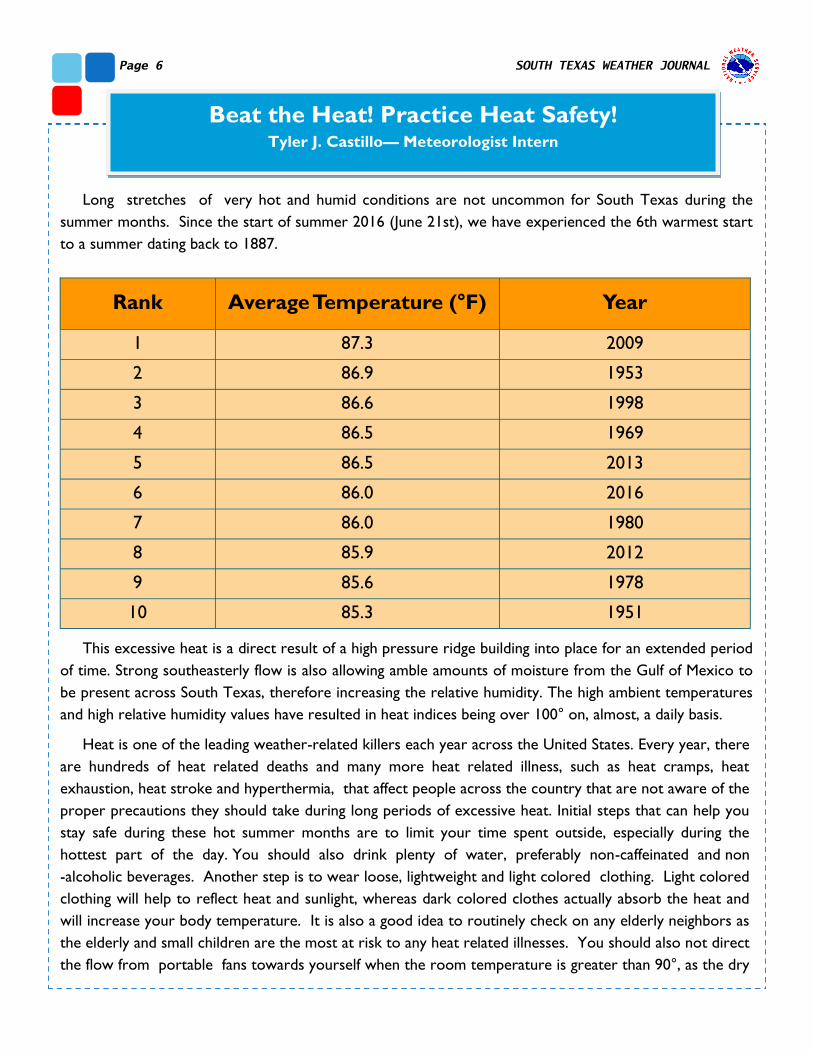
Long stretches of very hot and humid conditions are not uncommon for South Texas during the
summer months. Since the start of summer 2016 (June 21st), we have experienced the 6th warmest start
to a summer dating back to 1887.
This excessive heat is a direct result of a high pressure ridge building into place for an extended period
of time. Strong southeasterly flow is also allowing amble amounts of moisture from the Gulf of Mexico to
be present across South Texas, therefore increasing the relative humidity. The high ambient temperatures
and high relative humidity values have resulted in heat indices being over 100° on, almost, a daily basis.
Heat is one of the leading weather-related killers each year across the United States. Every year, there
are hundreds of heat related deaths and many more heat related illness, such as heat cramps, heat
exhaustion, heat stroke and hyperthermia, that affect people across the country that are not aware of the
proper precautions they should take during long periods of excessive heat. Initial steps that can help you
stay safe during these hot summer months are to limit your time spent outside, especially during the
hottest part of the day. You should also drink plenty of water, preferably non-caffeinated and non
-alcoholic beverages. Another step is to wear loose, lightweight and light colored clothing. Light colored
clothing will help to reflect heat and sunlight, whereas dark colored clothes actually absorb the heat and
will increase your body temperature. It is also a good idea to routinely check on any elderly neighbors as
the elderly and small children are the most at risk to any heat related illnesses. You should also not direct
the flow from portable fans towards yourself when the room temperature is greater than 90°, as the dry
Beat the Heat! Practice Heat Safety! Tyler J. Castillo— Meteorologist Intern
Rank Average Temperature (°F) Year
1 87.3 2009
2 86.9 1953
3 86.6 1998
4 86.5 1969
5 86.5 2013
6 86.0 2016
7 86.0 1980
8 85.9 2012
9 85.6 1978
10 85.3 1951
Page 7 Summer 2016 EDITION
blowing air will actually
dehydrate you faster, thus
endangering your health.
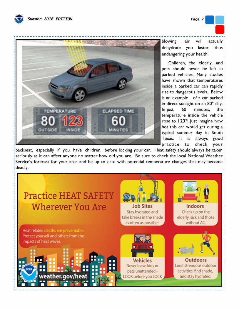
Children, the elderly, and
pets should never be left in
parked vehicles. Many studies
have shown that temperatures
inside a parked car can rapidly
rise to dangerous levels. Below
is an example of a car parked
in direct sunlight on an 80° day.
In just 60 minutes, the
temperature inside the vehicle
rose to 123°! Just imagine how
hot this car would get during a
typical summer day in South
Texas. It is always good
practice to check your
backseat, especially if you have children, before locking your car. Heat safety should always be taken
seriously as it can affect anyone no matter how old you are. Be sure to check the local National Weather
Service’s forecast for your area and be up to date with potential temperature changes that may become
deadly.
Page 8 SOUTH TEXAS WEATHER JOURNAL
MRMS FLASH: How Forecasters Are Using
This New Tool Greg Heavener—Senior Forecaster
Multi-Radar Multi-Sensor Flooded Locations and Simulated Hydrographs, better known as
MRMS FLASH, is a new tool used in National Weather Service forecast offices across the country.
Originally developed by the fine folks at the National Severe Storms Laboratory (NSSL), the
Cooperative Institute for Mesoscale Meteorological Studies (CIMMS), and the University of
Oklahoma (OU) a few years ago. The past two summers operational forecasters have been
invited to the NSSL hazardous weather testbed to utilize the FLASH data in real time and issue
test flash flood warnings, mimicking what is normally done in the NWS forecast offices. I
personally had the opportunity to test this data this past June and saw first -hand the value of this
new dataset.
Whenever the NWS issues a warning, whether it’s a severe thunderstorm warning, tornado
warning, or a flash flood warning, we strive to give the public as much heads up on the expected
impacts from these storms; otherwise known as lead time. Utilizing the MRMS FLASH data to
better pinpoint areas of potential flash flooding when heavy rains begin also gives forecasters
more confidence when going through their warning decision making process. Below is a quick
summary of what each new product shows and how it can add to warning lead time.
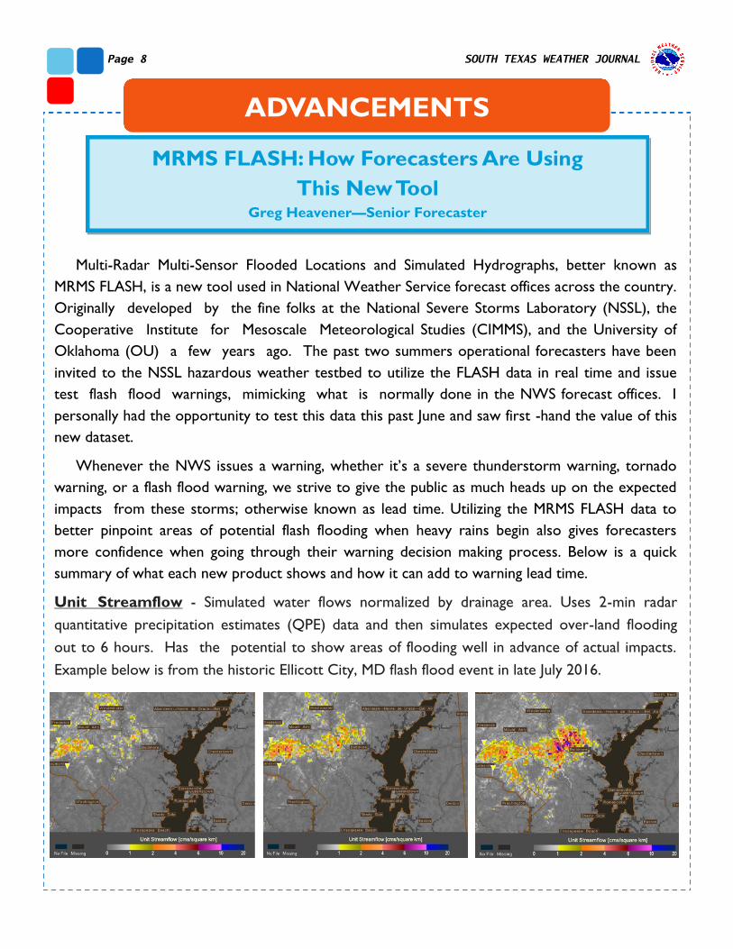
Unit Streamflow - Simulated water flows normalized by drainage area. Uses 2-min radar
quantitative precipitation estimates (QPE) data and then simulates expected over-land flooding
out to 6 hours. Has the potential to show areas of flooding well in advance of actual impacts.
Example below is from the historic Ellicott City, MD flash flood event in late July 2016.
ADVANCEMENTS
Page 9 Summer 2016 EDITION
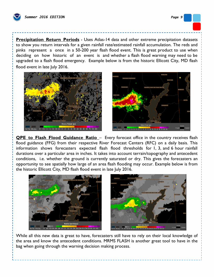
Precipitation Return Periods - Uses Atlas-14 data and other extreme precipitation datasets
to show you return intervals for a given rainfall rate/estimated rainfall accumulation. The reds and
pinks represent a once in a 50-200 year flash flood event. This is great product to use when
deciding on how historic of an event is and whether a flash flood warning may need to be
upgraded to a flash flood emergency. Example below is from the historic Ellicott City, MD flash
flood event in late July 2016.
QPE to Flash Flood Guidance Ratio – Every forecast office in the country receives flash
flood guidance (FFG) from their respective River Forecast Centers (RFC) on a daily basis. This
information shows forecasters expected flash flood thresholds for 1, 3, and 6 hour rainfall
durations over a particular area in inches. It takes into account terrain/topography and antecedent
conditions, i.e. whether the ground is currently saturated or dry. This gives the forecasters an
opportunity to see spatially how large of an area flash flooding may occur. Example below is from
the historic Ellicott City, MD flash flood event in late July 2016.
While all this new data is great to have, forecasters still have to rely on their local knowledge of
the area and know the antecedent conditions. MRMS FLASH is another great tool to have in the
bag when going through the warning decision making process.
Page 10 SOUTH TEXAS WEATHER JOURNAL
Corpus Christi NWR Transmitter Gets Upgrades Lara Keys—Journeyman Forecaster
ADVANCEMENTS
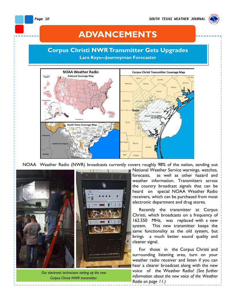
NOAA Weather Radio (NWR) broadcasts currently covers roughly 98% of the nation, sending out
National Weather Service warnings, watches,
forecasts, as well as other hazard and
weather information. Transmitters across
the country broadcast signals that can be
heard on special NOAA Weather Radio
receivers, which can be purchased from most
electronic department and drug stores.
Recently the transmitter at Corpus
Christi, which broadcasts on a frequency of
162.550 MHz, was replaced with a new
system. This new transmitter keeps the
same functionality as the old system, but
brings a much better sound quality and
cleaner signal.
For those in the Corpus Christi and
surrounding listening area, turn on your
weather radio receiver and listen if you can
hear a clearer broadcast along with the new
voice of the Weather Radio! (See further
information about the new voice of the Weather
Radio on page 11.)
Our electronic technicians setting up the new
Corpus Christi NWR transmitter.

Page 11 Summer 2016 EDITION
The Voice of the National Weather Service Lara Keys—Journeyman Forecaster
The history of the National Weather Service’s NOAA Weather
Radio broadcast goes back several decades and has undergone
many changes throughout the years. In the early 1960’s the U.S.
Weather Bureau began an experimental broadcast of marine
weather products in New York and Chicago. This proving a
success, the broadcasts grew further in content and expanded over
the U.S. throughout the next decade. By 1971 the program was
officially named NOAA Weather Radio (NWR) after the U.S.
Weather Bureau was changed to the National Weather Service
(NWS) under the National Oceanic and Atmospheric Association
(NOAA). Well before modern text-to-speech systems were
developed for the broadcast, local National Weather Service staff
could be heard on-air, reading broadcast alerts, forecasts, and
current weather and marine conditions. Weather alerts and
information were recorded onto tapes and inserted into tape decks
which would then play across local transmitters. By the late 1970’s there were over 300 NWR stations
across the country, with the program continuing to grow to over 800 station by the early 2000’s and over
1000 stations across the 50 states and U.S. territories as of this year.
By the late 1990’s a new method was implemented to speed up the dissemination of products to be
broadcast with the Console Replacement System (CRS). CRS used a text-to-speech voice synthesis which
would automatically convert all forecasts, warning, and weather information from a text product to a voice
product that would be read over the radio automatically. This greatly spread up the process of producing
and updating information, and allowed for multiple warnings to be transmitted over multiple transmitters at
once. The first computerized voice named “Paul,” was not well received, and subsequent updates were made
to automated voices of Weather Radio, with “Craig,” “Tom,” “Donna,” and “Javier,” all used from the early
2000’s until earlier this year.
Recently the NOAA Weather Radio has undergone another change within the weather forecast office
operations, transitioning from the Console Replacement System to the Broadcast Message Handler (BMH).
This new system comes with many internal updates to the NOAA Weather Radio broadcast system,
streamlining the process of bringing the most current weather alerts and updates from the hands of Weather
Service employees directly to the NWR and to listeners.
However, the most apparent change listeners will now hear
an updated voice, again dubbed “Paul,” who can be heard
speaking more in a far less robotic tenor. Although most
broadcasts continue to be automated, National Weather
Service staff does still have the capability to “go live” with
broadcasts and read directly on-air, as well as record
broadcasts to be played over the weather radio. A live voice
is most often heard during such things as the Routine Weekly
Test, a test conducted on Wednesdays between 11 AM and
noon to ensure all radios are functioning properly, as well as
during the Amber Alerts, and marine fishery announcements,
reminiscent of the old days of Weather Radio.

Page 12 SOUTH TEXAS WEATHER JOURNAL
Meteorologists Receive Decision Support Training
John Metz—Warning Coordination Meteorologist
When high impact weather events threaten
South Texas, National Weather Service (NWS)
meteorologists swing into action and provide
our partners with weather information that will
help them in making key decisions to protect life
and property. These decision support services
(DSS) help emergency managers and other local,
state, and federal partners understand the type
of impacts a particular weather event may have
on the region and their operations. Information
can be shared through a number of platforms,
including text message, phone conversation, email briefing, or conference call webinar. For big events like
a hurricane, our meteorologists can be embedded within the emergency operations center and provide
direct support.
In order to expand our DSS skill sets our office held a two-day workshop and invited a group of
expert facilitators from across the National Weather Service to Corpus Christi. Facilitators from the
NWS Regional Operation Center in Ft Worth, West Gulf River Forecast Center, and Weather Forecast
Offices in Houston and New Orleans shared their expertise with our meteorologists. This two-day
training workshop focused on topics ranging from risk communication, to social media best practices, to
effective graphics and briefings production. The event concluded with a half-day hurricane exercise in
which our meteorologists put into practice what
they learned. Several local media partners and
emergency managers participated in the exercise,
offering their expert advice as well. Local
partners included Newscenter 25 in Victoria as
well as emergency managers from the City of
Corpus Christi and Nueces County.
We want to thank all those who made this
event a great success. Our meteorologists are
now better prepared to support our partners
when the next high impact event threatens our
community.
EVENTS & OUTREACH
Meteorologists Greg Heavener and Lara Keys participate
in a mock hurricane briefing for the Corpus Christi
Emergency Operations Center
Page 13 Summer 2016 EDITION
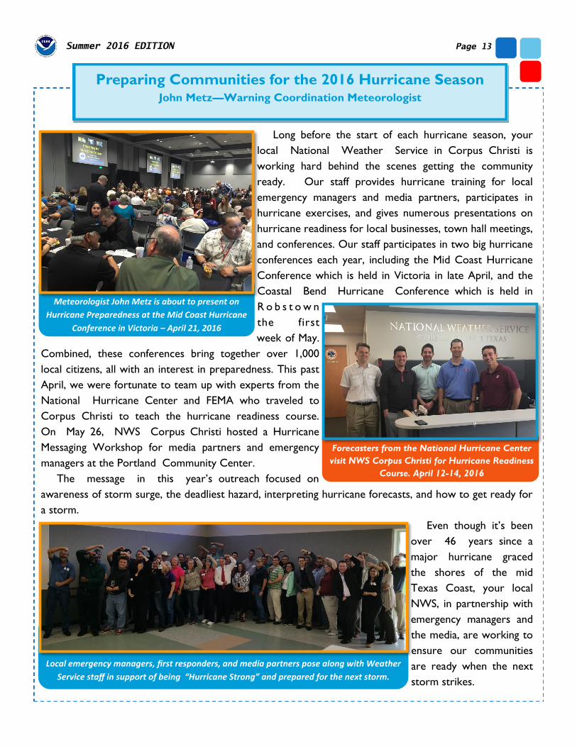
Preparing Communities for the 2016 Hurricane Season John Metz—Warning Coordination Meteorologist
Long before the start of each hurricane season, your
local National Weather Service in Corpus Christi is
working hard behind the scenes getting the community
ready. Our staff provides hurricane training for local
emergency managers and media partners, participates in
hurricane exercises, and gives numerous presentations on
hurricane readiness for local businesses, town hall meetings,
and conferences. Our staff participates in two big hurricane
conferences each year, including the Mid Coast Hurricane
Conference which is held in Victoria in late April, and the
Coastal Bend Hurricane Conference which is held in
R o b s t o w n
the first
week of May.
Combined, these conferences bring together over 1,000
local citizens, all with an interest in preparedness. This past
April, we were fortunate to team up with experts from the
National Hurricane Center and FEMA who traveled to
Corpus Christi to teach the hurricane readiness course.
On May 26, NWS Corpus Christi hosted a Hurricane
Messaging Workshop for media partners and emergency
managers at the Portland Community Center.
The message in this year’s outreach focused on
awareness of storm surge, the deadliest hazard, interpreting hurricane forecasts, and how to get ready for
a storm.
Even though it’s been
over 46 years since a
major hurricane graced
the shores of the mid
Texas Coast, your local
NWS, in partnership with
emergency managers and
the media, are working to
ensure our communities
are ready when the next
storm strikes.
Forecasters from the National Hurricane Center
visit NWS Corpus Christi for Hurricane Readiness
Course. April 12-14, 2016
Meteorologist John Metz is about to present on
Hurricane Preparedness at the Mid Coast Hurricane
Conference in Victoria – April 21, 2016
Local emergency managers, first responders, and media partners pose along with Weather
Service staff in support of being “Hurricane Strong” and prepared for the next storm.
SOUTH TEXAS WEATHER JOURNAL Page 14
.
STAFF SPOTLIGHT
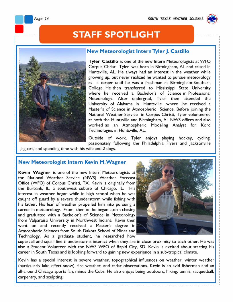
New Meteorologist Intern Tyler J. Castillo
New Meteorologist Intern Kevin M. Wagner
Kevin Wagner is one of the new Intern Meteorologists at
the National Weather Service (NWS) Weather Forecast
Office (WFO) of Corpus Christi, TX. Kevin is originally from
the Burbank, IL, a southwest suburb of Chicago, IL. His
interest in weather began while in high school when he was
caught off guard by a severe thunderstorm while fishing with
his father. His fear of weather propelled him into pursuing a
career in meteorology. From then on he began storm chasing
and graduated with a Bachelor’s of Science in Meteorology
from Valparaiso University in Northwest Indiana. Kevin then
went on and recently received a Master's degree in
Atmospheric Sciences from South Dakota School of Mines and
Technology. As a graduate student, he researched how
supercell and squall line thunderstorms interact when they are in close proximity to each other. He was
also a Student Volunteer with the NWS WFO of Rapid City, SD. Kevin is excited about starting his career in South Texas and is looking forward to gaining new experience in a sub-tropical climate.
Kevin has a special interest in severe weather, topographical influences on weather, winter weather
(particularly lake effect snow), fire weather, and radar observations. Kevin is an avid fisherman and an
all-around Chicago sports fan, minus the Cubs. He also enjoys being outdoors, hiking, tennis, racquetball,
carpentry, and sculpting.
Tyler Castillo is one of the new Intern Meteorologists at WFO
Corpus Christi. Tyler was born in Birmingham, AL and raised in
Huntsville, AL. He always had an interest in the weather while
growing up, but never realized he wanted to pursue meteorology
as a career until he was a freshman at Birmingham-Southern
College. He then transferred to Mississippi State University
where he received a Bachelor’s of Science in Professional
Meteorology. After undergrad, Tyler then attended the
University of Alabama in Huntsville where he received a
Master’s of Science in Atmospheric Science. Before joining the
National Weather Service in Corpus Christi, Tyler volunteered
at both the Huntsville and Birmingham, AL NWS offices and also
worked as an Atmospheric Modeling Analyst for Kord
Technologies in Huntsville, AL.
Outside of work, Tyler enjoys playing hockey, cycling, passionately following the Philadelphia Flyers and Jacksonville
Jaguars, and spending time with his wife and 2 dogs.
Page 15 Summer 2016 EDITION
The 2011 drought was the most intense one year drought on record for the State of Texas.
Over $8 billion dollars in agricultural losses were recorded across the state. Annual rainfall totals ranked
all time driest for Laredo and Victoria dating back to 1898.
DID YOU KNOW?
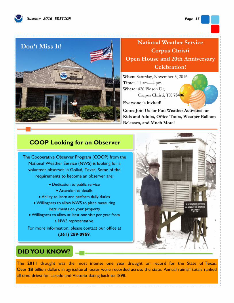
National Weather Service
Corpus Christi
Open House and 20th Anniversary
Celebration!
When: Saturday, November 5, 2016
Time: 11 am—4 pm
Where: 426 Pinson Dr,
Corpus Christi, TX 78406
Everyone is invited!
Come Join Us for Fun Weather Activities for
Kids and Adults, Office Tours, Weather Balloon
Releases, and Much More!
Don’t Miss It!
The Cooperative Observer Program (COOP) from the
National Weather Service (NWS) is looking for a
volunteer observer in Goliad, Texas. Some of the
requirements to become an observer are:
Dedication to public service
Attention to details
Ability to learn and perform daily duties
Willingness to allow NWS to place measuring
instruments on your property
Willingness to allow at least one visit per year from
a NWS representative.
For more information, please contact our office at
(361) 289-0959.
COOP Looking for an Observer
National Weather Service
WFO Corpus Christi, TX
426 Pinson Drive
Corpus Christi, TX
78406
Phone: 361-289-0959
Fax: 361-289-7823
www.weather.gov/corpuschristi
National Weather Service
Corpus Christi, TX
@NWSCorpus