Embed Size (px)
Citation preview
Chen Yulin, Shan-Shui-City: A Chinese Spatial Planning Tradition, 46th ISOCARP Congress 2010
1
Shan-Shui-City: A Chinese Spatial Planning Tradition and Its Implications on Urban Sustainability
Chen Yulin
1 Foreword
1.1 Research Background China has made tremendous achievements on urban construction since the opening reform policy in the 1980s. Accompanied with the rapid growth of both the quantity and the size of cities are a series of problems, such as the destruction of historic sites and deterioration of natural environment. Chinese cities have been facing challenges in maintaining their safety, characteristic and culture. While the western world offers many great precedents to deal with such problems, this research holds the hypothesis that we can also learn from the long-standing practice in urban construction in the old China itself.
1.2 Concept Definition “Shan-Shui-City” is one of the unique spatial planning concepts in the China’s history. It combines the urban construction and the natural environment which is mainly composed of the mountains (“Shan”) and the water (“Shui”). The concept dates back to ancient times of the mountain-water worship, followed by Wu Zixu’s idea of “locating cities by observing the earth and examining the water”, and the emperors’ locating cities on the strategic place of the surrounding natural environment for defense. Chinese planners in the old times emphasized a lot on choosing and borrowing the Shan-Shui environment when building cities. The integration of the city and natural environment in practice has gradually drawn a rich and deep “historic background” after thousands of years. Remained also is the design concept or vision of integrating the natural environment and cities, which includes lots of aesthetics and human settlement ideas. In the contemporary research in Chinese urban planning, literatures focusing on the “Shan-Shui-City” dates back to Wu’s research in 1987 on the Guilin city planning, in which Wu Liangyong introduced the concept of the “Shan-Shui-City.” Wu argued that the beauty of Guilin city is not only because of the beauty of the mountain and the water, but also because of the integration of the two, and further of the interactions with the city areas. 1Wu also analyzed the patterns of “Shan-Shui-City” in Sanya (1991) and Wuxi (1995).2 In 1990, Qian Xuesen wrote a letter to Wu proposing of establishing the concept of “Shan-shui City”3 by integrating the Shan-shui poems, traditional Chinese gardens and landscape paintings.4 This research developed the concept of “Shan-Shui-City” with the theoretical foundation of the Human Settlement Sciences (2000) advocated by Wu. 5 Wu argues that the tight integration of “architecture-landscape-city” is the core of the traditional Chinese city design theory and methodology, if there is any.6 The “Shan-Shui” refers to the natural environment, and the “City” refers to artificial environment; the integration of the two pays much attention to the urban planning and design activities that integrated the natural environment under the guidance of the Chinese traditional human settlement ideas. The essence of the “Shan-Shui-City” could be understood in three aspects. First, it is about functional mutual dependence. The natural environment offers the cities with natural resources and defense facilities. Second, it is about the aesthetics bringing out the best in each other. People living in the human settlement can be cultivated by “Shan-Shui” via building traditional gardens, exploring beauty spots and “Shan-Shui” related art work creation. Third, it is about the cultural integration. Both the “Shan” and the “Shui” has special cultural meanings in China, and people have been shaping local culture when creating the city together with the natural environment system.
Chen Yulin, Shan-Shui-City: A Chinese Spatial Planning Tradition, 46th ISOCARP Congress 2010
2
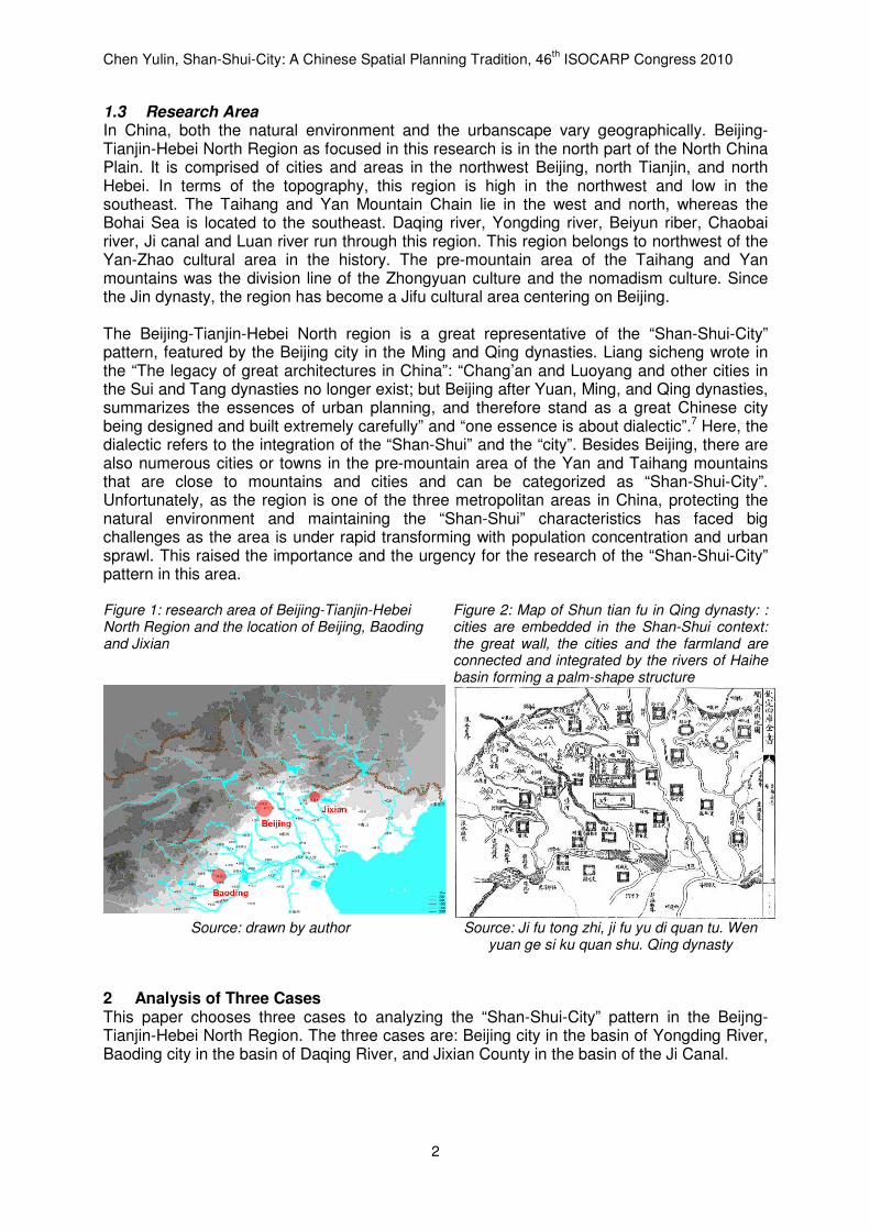
1.3 Research Area In China, both the natural environment and the urbanscape vary geographically. Beijing-Tianjin-Hebei North Region as focused in this research is in the north part of the North China Plain. It is comprised of cities and areas in the northwest Beijing, north Tianjin, and north Hebei. In terms of the topography, this region is high in the northwest and low in the southeast. The Taihang and Yan Mountain Chain lie in the west and north, whereas the Bohai Sea is located to the southeast. Daqing river, Yongding river, Beiyun riber, Chaobai river, Ji canal and Luan river run through this region. This region belongs to northwest of the Yan-Zhao cultural area in the history. The pre-mountain area of the Taihang and Yan mountains was the division line of the Zhongyuan culture and the nomadism culture. Since the Jin dynasty, the region has become a Jifu cultural area centering on Beijing. The Beijing-Tianjin-Hebei North region is a great representative of the “Shan-Shui-City” pattern, featured by the Beijing city in the Ming and Qing dynasties. Liang sicheng wrote in the “The legacy of great architectures in China”: “Chang’an and Luoyang and other cities in the Sui and Tang dynasties no longer exist; but Beijing after Yuan, Ming, and Qing dynasties, summarizes the essences of urban planning, and therefore stand as a great Chinese city being designed and built extremely carefully” and “one essence is about dialectic”.7 Here, the dialectic refers to the integration of the “Shan-Shui” and the “city”. Besides Beijing, there are also numerous cities or towns in the pre-mountain area of the Yan and Taihang mountains that are close to mountains and cities and can be categorized as “Shan-Shui-City”. Unfortunately, as the region is one of the three metropolitan areas in China, protecting the natural environment and maintaining the “Shan-Shui” characteristics has faced big challenges as the area is under rapid transforming with population concentration and urban sprawl. This raised the importance and the urgency for the research of the “Shan-Shui-City” pattern in this area. Figure 1: research area of Beijing-Tianjin-Hebei North Region and the location of Beijing, Baoding and Jixian
Figure 2: Map of Shun tian fu in Qing dynasty: : cities are embedded in the Shan-Shui context: the great wall, the cities and the farmland are connected and integrated by the rivers of Haihe basin forming a palm-shape structure
Source: drawn by author Source: Ji fu tong zhi, ji fu yu di quan tu. Wen yuan ge si ku quan shu. Qing dynasty
2 Analysis of Three Cases This paper chooses three cases to analyzing the “Shan-Shui-City” pattern in the Beijng-Tianjin-Hebei North Region. The three cases are: Beijing city in the basin of Yongding River, Baoding city in the basin of Daqing River, and Jixian County in the basin of the Ji Canal.
Chen Yulin, Shan-Shui-City: A Chinese Spatial Planning Tradition, 46th ISOCARP Congress 2010
3
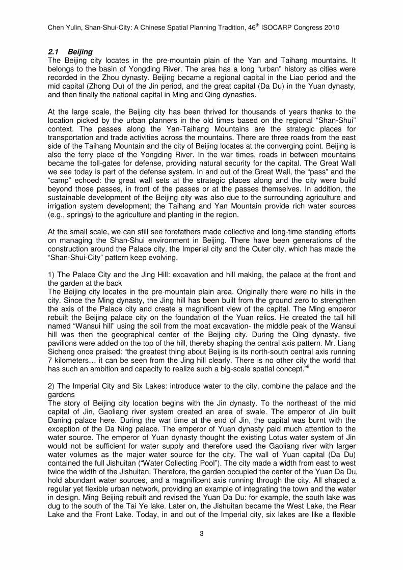
2.1 Beijing The Beijing city locates in the pre-mountain plain of the Yan and Taihang mountains. It belongs to the basin of Yongding River. The area has a long “urban" history as cities were recorded in the Zhou dynasty. Beijing became a regional capital in the Liao period and the mid capital (Zhong Du) of the Jin period, and the great capital (Da Du) in the Yuan dynasty, and then finally the national capital in Ming and Qing dynasties. At the large scale, the Beijing city has been thrived for thousands of years thanks to the location picked by the urban planners in the old times based on the regional “Shan-Shui” context. The passes along the Yan-Taihang Mountains are the strategic places for transportation and trade activities across the mountains. There are three roads from the east side of the Taihang Mountain and the city of Beijing locates at the converging point. Beijing is also the ferry place of the Yongding River. In the war times, roads in between mountains became the toll-gates for defense, providing natural security for the capital. The Great Wall we see today is part of the defense system. In and out of the Great Wall, the “pass” and the “camp” echoed: the great wall sets at the strategic places along and the city were build beyond those passes, in front of the passes or at the passes themselves. In addition, the sustainable development of the Beijing city was also due to the surrounding agriculture and irrigation system development; the Taihang and Yan Mountain provide rich water sources (e.g., springs) to the agriculture and planting in the region. At the small scale, we can still see forefathers made collective and long-time standing efforts on managing the Shan-Shui environment in Beijing. There have been generations of the construction around the Palace city, the Imperial city and the Outer city, which has made the “Shan-Shui-City” pattern keep evolving. 1) The Palace City and the Jing Hill: excavation and hill making, the palace at the front and the garden at the back The Beijing city locates in the pre-mountain plain area. Originally there were no hills in the city. Since the Ming dynasty, the Jing hill has been built from the ground zero to strengthen the axis of the Palace city and create a magnificent view of the capital. The Ming emperor rebuilt the Beijing palace city on the foundation of the Yuan relics. He created the tall hill named “Wansui hill” using the soil from the moat excavation- the middle peak of the Wansui hill was then the geographical center of the Beijing city. During the Qing dynasty, five pavilions were added on the top of the hill, thereby shaping the central axis pattern. Mr. Liang Sicheng once praised: “the greatest thing about Beijing is its north-south central axis running 7 kilometers… it can be seen from the Jing hill clearly. There is no other city the world that has such an ambition and capacity to realize such a big-scale spatial concept.”8 2) The Imperial City and Six Lakes: introduce water to the city, combine the palace and the gardens The story of Beijing city location begins with the Jin dynasty. To the northeast of the mid capital of Jin, Gaoliang river system created an area of swale. The emperor of Jin built Daning palace here. During the war time at the end of Jin, the capital was burnt with the exception of the Da Ning palace. The emperor of Yuan dynasty paid much attention to the water source. The emperor of Yuan dynasty thought the existing Lotus water system of Jin would not be sufficient for water supply and therefore used the Gaoliang river with larger water volumes as the major water source for the city. The wall of Yuan capital (Da Du) contained the full Jishuitan (“Water Collecting Pool”). The city made a width from east to west twice the width of the Jishuitan. Therefore, the garden occupied the center of the Yuan Da Du, hold abundant water sources, and a magnificent axis running through the city. All shaped a regular yet flexible urban network, providing an example of integrating the town and the water in design. Ming Beijing rebuilt and revised the Yuan Da Du: for example, the south lake was dug to the south of the Tai Ye lake. Later on, the Jishuitan became the West Lake, the Rear Lake and the Front Lake. Today, in and out of the Imperial city, six lakes are like a flexible
Chen Yulin, Shan-Shui-City: A Chinese Spatial Planning Tradition, 46th ISOCARP Congress 2010
4
central park in the middle of the regular grid system of the city. Those lakes were once the recreational places for royalty, and now became popular sites for both locals and tourists to see mountains and water. Mr. Liang Sicheng once highly complimented the “Shan-Shui-City” pattern of Beijing: “It is a genius idea for putting gardens inside the city. Such a city did not exist in other parts of the world, and even in the modern time using the most advanced urban planning theory, it still presents great advantages over other arrangements.”9 3) The Outer City and “Three Mountains and Five Gardens”: make the garden out of springs, double-city of the garden and the palace There were natural lakes in the northwest of the Beijing city, an area that was famous as the “South of the Yangzi River” in the northern China. Ming people had started building gardens here. The Qing emperors came from the forest in the north east region. The habits of horse riding and arrow shooting made them used to be close to the natural garden life. Therefore they built more summer or winter palaces than emperors in any other dynasty. Till the Qing Qianlong period, the “three mountains and five gardens” were shaped. The area plus those surrounding private gardens total more than 20 square kilometers, and Beijing is like a “garden city” with a garden-palace “double core” structure. The three mountains and five gardens are not only a complementary to the landscape of the Beijing city, but also a crucial source for water daily use in palace and for transport. Jin dynasty introduced the spring from the Yuquan Mountain to improve the water transport infrastructure. In Yuan dynasty, Mr. Guo Shoujing built weirs at the Baifu village in Changping, introducing springs in the Longwang Mountain to the lake of Mount Weng. This has transformed the Mount Weng as a reservoir signalizing the completion of the Beijing-Hangzhou great canal. In the Qing Qianlong period, the water system in the three mountains and five gardens was renovated to back up water for gardens and to develop surrounding farmlands. Actions include: dredging up the mouths of springs and the mount of Weng, building embankment and gates. The water system wes used for both the water supply but also the irrigation and flood discharge. The “greatest sceneries” are common in traditional Chinese cities.10 In the Ming dynasty, among the “ten greatest sceneries” of Yan Jing,11 eight of them are related to the mountain and water. The ten sceneries contain recreational palaces, suburb agriculture sites, and some view points in terms of military defense and water transport. These embody the integration of the function, aesthetics, and culture from many directions. From a spatial distribution, the “Shan-Shui-City” pattern has rich multi spatial layers, including the Imperial city, the Outer city and Jifu Region.
Chen Yulin, Shan-Shui-City: A Chinese Spatial Planning Tradition, 46th ISOCARP Congress 2010
5
Figure 3: the “Shan-Shui-City” pattern of the Palace city, the Imperial city and the Outer city of old Beijing
Source: drawn on the base maps of: Liu, D., 1997, History of Ancient Chinese Architecture, 2nd ed,
Beijing: China Architecture & Building Press (left); Jing shi wu cheng fang xiang hu tong ji, Ming dynasty (middle); Zhou, W., 1999, History of Chinese Classical Gardens, 2nd ed, Beijing: Tsinghua
University Press (right)
2.2 Baoding Baoding locates in the pre-mountain plain area of the Taihang mountain, and between the north and south branches of the Daqing River. In the old times, Baoding was often the point of battle because of its strategic place. Since the Yuan dynasty, the city was rebuilt and gradually developed to a great metropolitan area in the south Yan (Beijing area). The Baoding Local Chronicles in Ming dynasty characterized its Shan-Shui context as “mountains in the west”, “rivers entangled”, etc.12 Specifically, to the west of Baoding is the Taihang Mountain and there are great wall and passes as the military forts. Especially, the Zijing Pass, Yi County, and Qing East-Imperial Tomb formed a defense system which integrated the city and the natural environment. Along the two branches of the Da Qing River, there were fertile farmlands serving as an agriculture base for the region. To the east of Baoding are a group of shallow lakes (so-called “Bai-Yang Dien Lake”) where the agriculture was also quite developed there. Today, the Bai-Yang Dien lake has shrunk to 336 square kilometers, yet still the largest freshwater wetland in the North China Plain. The construction of Baoding city has much to do with the spring in the Mancheng city. Mancheng city locates 18 kilometers to the northwest of the Baoding city. The county has an isolated hill in the west which belongs to the extensive Taihang Mountain chain. To its east and south are wide plains. Mancheng city has rich water source and is famous of Jiju spring and Yimu sping.13 In 1213, the Yuan army captured Baozhou state and made it a relic place. In 1226, the city was rebuilt because the army led by Mr. Zhang Rou decided to stay for defense purpose. At the beginning, the water from well was not drinkable and springs of the Mancheng city were abandoned. Zhang Rou scrutinized the typography and introduced the spring into the city.14 This did not only improve the water quality, but also created five ponds and four gardens, thus adding a unique landscape feature to this plain area city. 15In the Qing dynasty, one of the four gardens in Baoding were turned into a summer and winter palace and renamed as Lotus Pool. According to the “Baoding eight greatest sceneries” in the Qing dynasty, there are “Lotus Blooming” inside the town, “East marsh Spring rain”, “West temple Fall billows”, and “Jiju clean rings” in the outskirts, all depicting the city’s water source and surrounding farmland, and “Langya Stands tall” in the exurb, sketching the beautiful and lofty mountains on the west.
Chen Yulin, Shan-Shui-City: A Chinese Spatial Planning Tradition, 46th ISOCARP Congress 2010
6
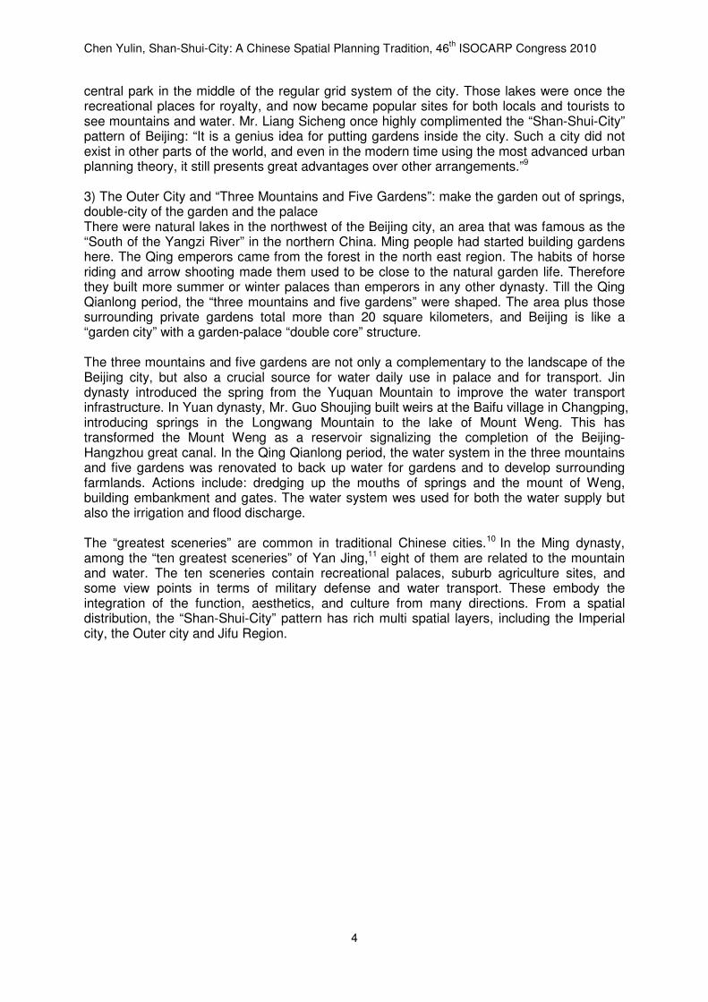
Figure 4: Map of Baoding fu area in Ming dynasty: Baoding city is surrounded by Shan-Shui with Taihang Mountain on the west and Bai-Yang Dien Lake on the east.
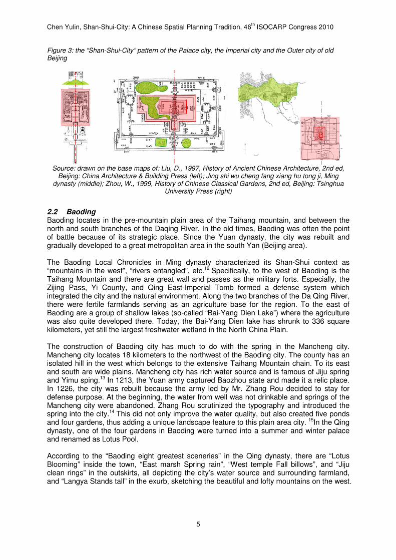
Figure 5: Map of Baoding city in Qing dynasty: Baoding city is full of lakes and rivers with the Lotus Pool located in the center.
Source: Bao ding fu zhi, juan er,Ming dynasty
(1607) Source: Bao ding fu zhi, Qing dynasty (1680)
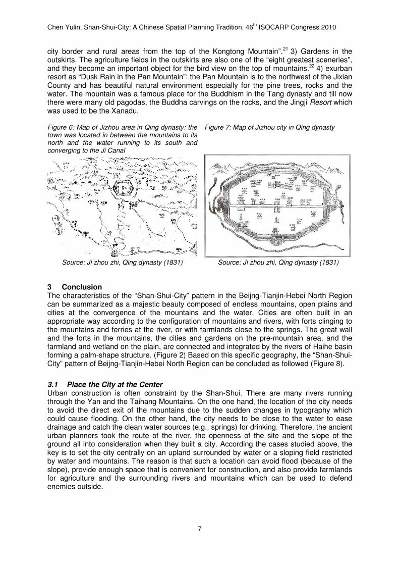
2.3 Jixian Jixian County locates in the basin of Ji Canal and in the pre-mountain area of the Yan Mountain. Jixian County was an important military site along the south side of the Yan Mountain in the old times and particularly for the Jifu region since the Jin and Yuan dynasties. The strategic place for defense purposes and fertile farmlands around has been the foundation of the sustainable development of the Jixian County in history. The town was located in between the mountains to its north and the water running to its south and converging to the Ji Canal. The upriver Ji Canal has a series of forts. Among them, Huangya Fort locates at the exit of Ju River out of the Yan Mountain. The pass town has many layers of mountains as a barrier to the north, steep cliffs on the west and east, and magnificent Ju river to the south. In other words, the pass town was built at the interchange of the mountains and the water. Making use of this “Shan-Shui” context, the Huangya Fort became in fact a comprehensive defense system which was composed of the fort walls, main pass, water pass, the east and the west passes. Located to the south of Jixian County are the Jizhou and Yutian Plain. This area has been an agriculture base serving the local region since the Warrior States Period. Till now, there are still some shallow lakes that are dispersed throughout the plain region to the south of the Jixian County which is characterized by the landscape of paddy fields. It is a tradition in China that cities are built in front of mountains to hold the strategic place for defense. The “Local Chronicles of Jizhou” in Ming dynasty says: “the old town of the Jizhou leans against the mountains to the north and adjacent to the Gu river to the south”.16 The town location selection considered the role of Kongtong Mountain and the Gu water: it is in front of the highest Kongtong mountain, which not only strengthens the defense but also serves as a magnificent backdrop for the town.17 The Jixian County also uses Gu Water system for drainage.18 The “Shan-Shui-City” pattern is thereby shaped. The famous “Yu-Yang eight great sceneries”19 highlight the “Shan-Shui-City” pattern of the Jixian County. 1) Dule’s light in the dawn: the Dule Temple was firstly built in the Tang dynasty, whereas the Kwan-yin pavilion and the hill gate were rebuilt in the Liao dynasty. 300 meters south to the Dule temple is the White Pagoda (a.k.a Yu-Yang Pagoda in the old times). The temple and the pagoda are used to be not only the highest points of the city, but also the Buddhism icon. Mr. Liang Sicheng praised the echo of the Dule temple and the White Pagoda as “the greatest urban design and plane arrangement in the Ji town created 1000 years ago”.20 2) Mountain and Water surrounding the town: The city leans against the Kongtong Mountain, which has the great scenery known as “the snow on the Kong Tong”. The “Local Chronicles of Jizhou” in Qing dynasty records that “one can see everything of the
Chen Yulin, Shan-Shui-City: A Chinese Spatial Planning Tradition, 46th ISOCARP Congress 2010
7
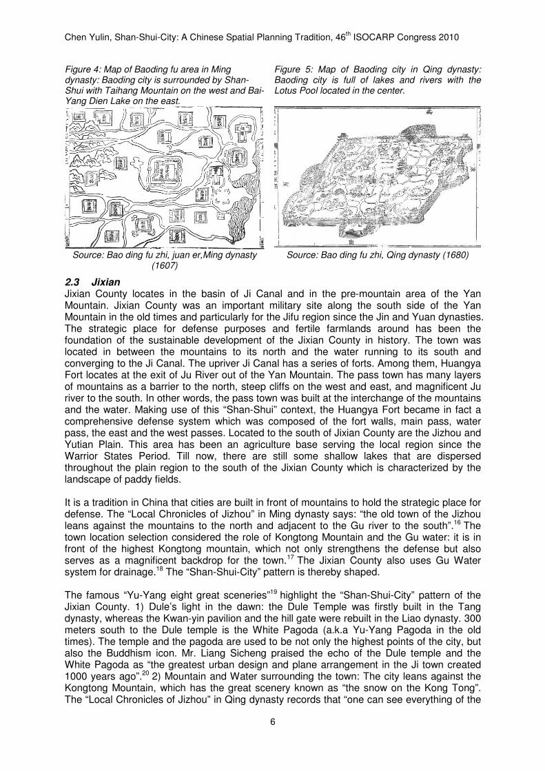
city border and rural areas from the top of the Kongtong Mountain”.21 3) Gardens in the outskirts. The agriculture fields in the outskirts are also one of the “eight greatest sceneries”, and they become an important object for the bird view on the top of mountains.22 4) exurban resort as “Dusk Rain in the Pan Mountain”: the Pan Mountain is to the northwest of the Jixian County and has beautiful natural environment especially for the pine trees, rocks and the water. The mountain was a famous place for the Buddhism in the Tang dynasty and till now there were many old pagodas, the Buddha carvings on the rocks, and the Jingji Resort which was used to be the Xanadu. Figure 6: Map of Jizhou area in Qing dynasty: the town was located in between the mountains to its north and the water running to its south and converging to the Ji Canal
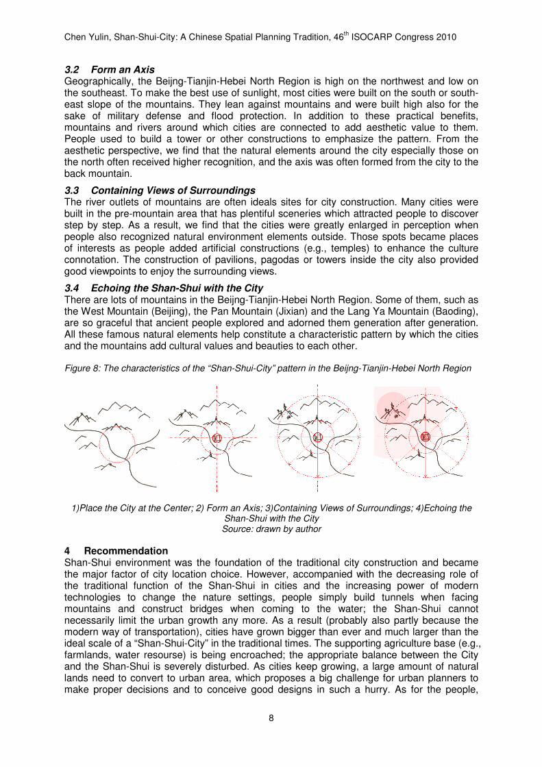
Figure 7: Map of Jizhou city in Qing dynasty
Source: Ji zhou zhi, Qing dynasty (1831) Source: Ji zhou zhi, Qing dynasty (1831)
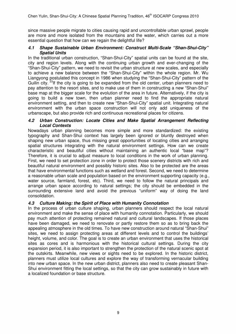
3 Conclusion The characteristics of the “Shan-Shui-City” pattern in the Beijng-Tianjin-Hebei North Region can be summarized as a majestic beauty composed of endless mountains, open plains and cities at the convergence of the mountains and the water. Cities are often built in an appropriate way according to the configuration of mountains and rivers, with forts clinging to the mountains and ferries at the river, or with farmlands close to the springs. The great wall and the forts in the mountains, the cities and gardens on the pre-mountain area, and the farmland and wetland on the plain, are connected and integrated by the rivers of Haihe basin forming a palm-shape structure. (Figure 2) Based on this specific geography, the “Shan-Shui-City” pattern of Beijng-Tianjin-Hebei North Region can be concluded as followed (Figure 8).
3.1 Place the City at the Center Urban construction is often constraint by the Shan-Shui. There are many rivers running through the Yan and the Taihang Mountains. On the one hand, the location of the city needs to avoid the direct exit of the mountains due to the sudden changes in typography which could cause flooding. On the other hand, the city needs to be close to the water to ease drainage and catch the clean water sources (e.g., springs) for drinking. Therefore, the ancient urban planners took the route of the river, the openness of the site and the slope of the ground all into consideration when they built a city. According the cases studied above, the key is to set the city centrally on an upland surrounded by water or a sloping field restricted by water and mountains. The reason is that such a location can avoid flood (because of the slope), provide enough space that is convenient for construction, and also provide farmlands for agriculture and the surrounding rivers and mountains which can be used to defend enemies outside.
Chen Yulin, Shan-Shui-City: A Chinese Spatial Planning Tradition, 46th ISOCARP Congress 2010
8
3.2 Form an Axis Geographically, the Beijng-Tianjin-Hebei North Region is high on the northwest and low on the southeast. To make the best use of sunlight, most cities were built on the south or south-east slope of the mountains. They lean against mountains and were built high also for the sake of military defense and flood protection. In addition to these practical benefits, mountains and rivers around which cities are connected to add aesthetic value to them. People used to build a tower or other constructions to emphasize the pattern. From the aesthetic perspective, we find that the natural elements around the city especially those on the north often received higher recognition, and the axis was often formed from the city to the back mountain.
3.3 Containing Views of Surroundings The river outlets of mountains are often ideals sites for city construction. Many cities were built in the pre-mountain area that has plentiful sceneries which attracted people to discover step by step. As a result, we find that the cities were greatly enlarged in perception when people also recognized natural environment elements outside. Those spots became places of interests as people added artificial constructions (e.g., temples) to enhance the culture connotation. The construction of pavilions, pagodas or towers inside the city also provided good viewpoints to enjoy the surrounding views.
3.4 Echoing the Shan-Shui with the City There are lots of mountains in the Beijng-Tianjin-Hebei North Region. Some of them, such as the West Mountain (Beijing), the Pan Mountain (Jixian) and the Lang Ya Mountain (Baoding), are so graceful that ancient people explored and adorned them generation after generation. All these famous natural elements help constitute a characteristic pattern by which the cities and the mountains add cultural values and beauties to each other. Figure 8: The characteristics of the “Shan-Shui-City” pattern in the Beijng-Tianjin-Hebei North Region
1)Place the City at the Center; 2) Form an Axis; 3)Containing Views of Surroundings; 4)Echoing the Shan-Shui with the City Source: drawn by author
4 Recommendation Shan-Shui environment was the foundation of the traditional city construction and became the major factor of city location choice. However, accompanied with the decreasing role of the traditional function of the Shan-Shui in cities and the increasing power of modern technologies to change the nature settings, people simply build tunnels when facing mountains and construct bridges when coming to the water; the Shan-Shui cannot necessarily limit the urban growth any more. As a result (probably also partly because the modern way of transportation), cities have grown bigger than ever and much larger than the ideal scale of a “Shan-Shui-City” in the traditional times. The supporting agriculture base (e.g., farmlands, water resourse) is being encroached; the appropriate balance between the City and the Shan-Shui is severely disturbed. As cities keep growing, a large amount of natural lands need to convert to urban area, which proposes a big challenge for urban planners to make proper decisions and to conceive good designs in such a hurry. As for the people,
Chen Yulin, Shan-Shui-City: A Chinese Spatial Planning Tradition, 46th ISOCARP Congress 2010
9
since massive people migrate to cities causing rapid and uncontrollable urban sprawl, people are more and more isolated from the mountains and the water, which carries out a more essential question that how can we regain the delightful life?
4.1 Shape Sustainable Urban Environment: Construct Multi-Scale “Shan-Shui-City” Spatial Units
In the traditional urban construction, “Shan-Shui-City” spatial units can be found at the site, city and region levels. Along with the continuing urban growth and ever-changing of the “Shan-Shui-City” pattern, we need to revisit the urban structure at new scales, and especially to achieve a new balance between the “Shan-Shui-City” within the whole region. Mr. Wu Liangyong postulated this concept in 1986 when studying the “Shan-Shui-City” pattern of the Guilin city. 23If the city is going to be expanded from the old center, urban planners need to pay attention to the resort sites, and to make use of them in constructing a new “Shan-Shui” base map at the bigger scale for the evolution of the area in future. Alternatively, if the city is going to build a new town, then urban planner need to find the appropriate natural environment setting, and then to create new “Shan-Shui-City” spatial unit. Integrating natural environment with the urban space construction will not only add uniqueness of the urbanscape, but also provide rich and continuous recreational places for citizens.
4.2 Urban Construction: Locate Cities and Make Spatial Arrangement Reflecting Local Contexts
Nowadays urban planning becomes more simple and more standardized: the existing typography and Shan-Shui context has largely been ignored or bluntly destroyed when shaping new urban space, thus missing great opportunities of locating cities and arranging spatial structures integrating with the natural environment settings. How can we create characteristic and beautiful cities without maintaining an authentic local “base map”? Therefore, it is crucial to adjust measure to local conditions in the work of urban planning. First, we need to set protection zone in order to protect those scenery districts with rich and beautiful natural environment and possibly historic sites. Also to be protected are the areas that have environmental functions such as wetland and forest. Second, we need to determine a reasonable urban scale and population based on the environment supporting capacity (e.g., water source, farmland, forest, etc). Third, we need to follow the natural principals and arrange urban space according to natural settings; the city should be embedded in the surrounding extensive land and avoid the previous “uniform” way of doing the land consolidation.
4.3 Culture Making: the Spirit of Place with Humanity Connotation In the process of urban culture shaping, urban planners should respect the local natural environment and make the sense of place with humanity connotation. Particularly, we should pay much attention of protecting remained natural and cultural landscapes. If those places have been damaged, we need to renovate or partly restore them so as to bring back the appealing atmosphere in the old times. To have new construction around natural “Shan-Shui” sites, we need to assign protecting areas at different levels and to control the buildings’ height, volume, and color. The goal is to create an urban environment that uses the historical sites as cores and is harmonious with the historical cultural settings. During the city expansion period, it is also important to strengthen the protection of the natural scenic spot at the outskirts. Meanwhile, new views or sights need to be explored. In the historic district, planners must utilize local cultures and explore the way of transforming vernacular building into new urban space. In the new urban district, planners also need to create pleasant Shan-Shui environment fitting the local settings, so that the city can grow sustainably in future with a localized foundation or base structure.
Chen Yulin, Shan-Shui-City: A Chinese Spatial Planning Tradition, 46th ISOCARP Congress 2010
10
Reference Bao, S., Gu, M., ed., 1996, Qian Xuesen’s Theory on urbanology and Shanshui City, 2nd ed, Beijing: China Architecture & Building Press, p. 47; pp. 88-93 Liang, S., 2001, Collection of Sicheng Liang’s Works, Beijing: China Architecture & Building Press, Vol.1, p. 225; Vol.5, pp. 99-100 Liu, D., 1997, History of Ancient Chinese Architecture, 2nd ed, Beijing: China Architecture & Building Press Wu, L., 1996, Urban research papers of Wu Liangyong (1986-1995): meeting the new era, Beijing: China Architecture & Building Press, pp. 238-336; 337-342 Wu, L., 2000, “Implications of Chinese traditional human settlements concept on contemporary urban design”, World Architecture, Vol.115, pp. 82-85 Wu, L., 2001, Introduction to Sciences of Human Settlements, Beijing: China Architecture & Building Press Zhou, W., 1999, History of Chinese Classical Gardens, 2nd ed, Beijing: Tsinghua University Press
Bao ding fu zhi, Ming dynasty (1607) ((明)冯惟敏纂修, 王国桢续修, 王政熙续纂. 保定府志•卷二. 明万历三十五年刊本(1607))
Bao ding fu zhi, Qing dynasty (1680) ((清)纪弘谟等修. 保定府志. 清康熙十九年(1680)刻本)
Ji fu an lan zhi, Qing dynasty ((清)王履泰. 畿辅安澜志. 影印天津图书馆藏清武英殿聚珍版印本. 上海: 上海古籍出版社, 1995)
Ji fu he dao shui li cong shu, Qing dynasty ((清)吴邦庆 辑, 许道龄 校. 畿辅河道水利丛书. 北京: 农业出版社,
1964)
Ji fu tong zhi, ji fu yu di quan tu. Wen yuan ge si ku quan shu. Qing dynasty ((清)畿辅通志•畿辅舆地全图卷. 文渊阁《四库全书》本)
Ji zhou zhi, Ming dynasty (1524) ((明)熊相. 蓟州志. 明嘉靖三年(1524)刻本)
Ji zhou zhi, Qing dynasty (1831) ((清)沈锐 纂修. 蓟州志. 清道光十一年(1831)刻本)
Ji zhou zhi, Qing dynasty (1704) ((清)张朝琮 纂修. 蓟州志·疆域志. 清康熙四十三年(1704)刻本)
Ji zhou zhi, Minguo (1944) ((民国)仇锡廷 纂. 蓟州志. 民国三十三年(1944)铅印本)
Jing shi wu cheng fang xiang hu tong ji, Ming dynasty ((明)张爵. 京师五城坊巷胡同集. 北京: 北京古籍出版社,
1982)
Ming hong li bao ding jun zhi, Ming dynasty (1494), pp. 18-19 ((明)章律修, 张才纂, 徐珪重编. 明弘治保定郡志·卷一·形胜. 天一阁藏明代方志选刊. 明弘治七年刻本(1494), pp. 18-19)
“Shun tian fu ying jian ji”. Yuan dynasty (1250) ((元)元好问《顺天府营建记》(1250))
Yuan shi, Ming dynasty ((明)宋濂 等. 元史·卷一百四十七 张柔传. 北京: 中华书局, 1976)
CHEN Yulin, Post-doctor in Department of Sociology, Tsinghua University. China 1 Wu, L., 1996, “Architecture culture, city pattern and protection measures of Guilin city”, Urban
research papers of Wu Liangyong (1986-1995): meeting the new era, Beijing: China Architecture & Building Press, pp. 238-336
2 Wu, L., 1996, “Reasoning on Shan-shui City”, Urban research papers of Wu Liangyong (1986-1995):
meeting the new era, Beijing: China Architecture & Building Press, pp. 337-342 3 Qian, X., 1996, “Letter to Wu Liangyong on the subject of ‘Shan-shui city’”, Bao, S., Gu, M., ed., Qian
Xuesen’s Theory on urbanology and Shan-shui City, 2nd ed, Beijing: China Architecture & Building Press, p. 47
4 Qian, X., 1996, “Socialist China must build ‘Shan-shui cities’”, Bao, S., Gu, M., ed., Qian Xuesen’s
Theory on urbanology and Shan-shui City, 2nd ed, Beijing: China Architecture & Building Press, pp. 88-93
5 Wu, L., 2001, Introduction to Sciences of Human Settlements, Beijing: China Architecture & Building Press
6 Wu, L., 2000, “Implications of Chinese traditional human settlements concept on contemporary urban design”, World Architecture, Vol.115, pp. 82-85
Chen Yulin, Shan-Shui-City: A Chinese Spatial Planning Tradition, 46th ISOCARP Congress 2010
11
7 Liang, S., 2001, “The legacy of great architectures in China”, Collection of Sicheng Liang’s Works, Vol.5,
Beijing: China Architecture & Building Press, pp. 99-100 8 Liang, S., 2001, “The legacy of great architectures in China”, Collection of Sicheng Liang’s Works, Vol.5,
Beijing: China Architecture & Building Press, p. 100 9 Liang, S., 2001, “The legacy of great architectures in China”, Collection of Sicheng Liang’s Works, Vol.5,
Beijing: China Architecture & Building Press, p. 100 10 The culture of “greatest sceneries” became popular in China since Song Dynasty. 11 At the beginnings there were “Eight Sceneries” in Beijing in Jin dynasty and two more sceneries
were added in Ming dynasty.
12 Ming hong li bao ding jun zhi, Ming dynasty (1494), pp. 18-19 ((明)章律修, 张才纂, 徐珪重编. 明弘治保定郡志·卷一·形胜. 天一阁藏明代方志选刊. 明弘治七年刻本(1494), pp. 18-19)
13 Ji fu an lan zhi, Qing dynasty ((清)王履泰. 畿辅安澜志. 影印天津图书馆藏清武英殿聚珍版印本. 上海: 上海古籍出版社, 1995)
14 Yuan shi, Ming dynasty ((明)宋濂 等. 元史·卷一百四十七 张柔传. 北京: 中华书局, 1976)
15 “Shun tian fu ying jian ji”. Yuan dynasty (1250) ((元)元好问《顺天府营建记》(1250))
16 Ji zhou zhi, Ming dynasty (1524) ((明)熊相. 蓟州志. 明嘉靖三年(1524)刻本)
17 Ji zhou zhi, Qing dynasty (1704) ((清)张朝琮 纂修. 蓟州志·疆域志. 清康熙四十三年(1704)刻本)
18 Ji fu he dao shui li cong shu, Qing dynasty ((清)吴邦庆. 营田水利图说, (清)吴邦庆 辑, 许道龄 校. 畿辅河道水利丛书. 北京: 农业出版社, 1964)
19 Ji zhou zhi, Ming dynasty (1524) ((明)熊相. 蓟州志. 明嘉靖三年(1524)刻本)
20 Liang, S. 2001 “Record of Kwan-yin pavilion and White Pagoda in Jixian county”, Collection of
Sicheng Liang’s Works, Vol.5, Beijing: China Architecture & Building Press: 225, first published in 1932
21 Ji zhou zhi, Qing dynasty (1704) ((清)张朝琮 纂修. 蓟州志·疆域志. 清康熙四十三年(1704)刻本)
22 Ji zhou zhi, Minguo (1944) ((民国)仇锡廷 纂. 蓟州志. 民国三十三年(1944)铅印本)
23 Wu, L., 1996, “Architecture culture, city pattern and protection measures of Guilin city”, Urban
research papers of Wu Liangyong (1986-1995): meeting the new era, Beijing: China Architecture & Building Press. pp. 238-336