Embed Size (px)
Citation preview
www.defra.gov.uk
Shoreline management plan guidanceVolume 1: Aims and requirements
March 2006
Plain English CampaignPO Box 3New MillsHigh PeakSK22 4QP
Telephone:01663 744409Fax: 01663 747038Website: www.plainenglish.co.uk
Department for Environment, Food and Rural AffairsNobel House17 Smith SquareLondon SW1P 3JRTelephone: 020 7238 6000Website: www.defra.gov.uk
© Crown copyright 2006
Copyright in the typographical arrangement and design rests with the Crown.
This publication (excluding the logo) may be reproduced free of charge in any format or medium provided that it is reproduced accurately and not used in a misleading context. The material must be acknowledged as Crown copyright with the title and source of the publication specified.
You can get more copies of this document and the supporting appendices from our website at:www.defra.gov.uk/environ/fcd/
Published by the Department for Environment, Food and Rural Affairs. Printed in the UK, March 2006, on material that contains a minimum of 100% recycled fibrefor uncoated paper and 75% recycled fibre for coated paper.
PB 11726
Shoreline management plan guidanceVolume 1: Aims and requirements
March 2006
ForewordSince we introduced the original guidance in 1995, shoreline management plans (SMPs) nowcover the entire shoreline of England and Wales. However, the SMP initiative was a new ideaand we have learnt much.
Although existing SMPs are excellent strategic documents, they need:
• more emphasis on improved links with the planning system;
• more consideration of effects on the environment; and
• longer-term coastal policies.
In 2001 we produced an updated guide, taking account of all the lessons we had learnt.
We also considered that more research was needed into how the coast would change.We asked for national research on coastal changes in England and Wales (a ‘future coastalevolution study’, known as Futurecoast), which was completed in 2002. This research will beimportant for SMP reviews.
SMPs offer coastal operating authorities an opportunity to assess longer-term implications forprotecting the coast. As a result, we have prepared this guidance with the main operatingauthorities and other people who have an interest in the coast.
The process will involve stakeholders (see the glossary) at all levels working to achieve a betterbalance between economic, social and environmental development in managing coastal risks. They will also support river basin management plans under the Water Framework Directive(see the glossary) and other coastal initiatives, including the new integrated coastal zonemanagement strategy (see the glossary).
Flood Management DivisionDepartment for Environment, Food and Rural Affairs
March 2006
© Department for Environment, Food and Rural Affairs 2006
AcknowledgementsWe (Defra) have issued this guidance following full consultation with a wide range of interestedpeople, and the Welsh Assembly Government (WAG) will use it. We are grateful for the adviceand guidance of the steering group members and others who have provided useful commentswhile developing this guidance. Below are members of the steering group.
Mr J Hutchison, Defra (Chair)
Mr T Collins, Natural England
Mr P Frew, North Norfolk District Council
Mr S Herrington, Shepway District Council (now independent)
Mr K Keirle, Welsh Assembly Government
Mr P Murby, Defra
Mr C Pater, Natural England (now English Heritage)
Ms J Rawson, Environment Agency
Mr R Spencer, Arun District Council
Mr G Watson, North Norfolk District Council
Mr S Worrall, Environment Agency
A group of companies (led by Halcrow Group Ltd) developed this guidance. The project managerwas Mr A Hosking and the project director was Mr K Burgess. As part of the group, manypeople and organisations from across the UK involved in managing floods and the coastcontributed to the guidance.
We are grateful for all the contributions and comments we received.
1
Contents
List of figures, boxes and plates 2
Chapter One: Introduction 3
1.1 SMP guidance documents 41.2 Background 41.3 Lessons learnt and revised guidance 8
Chapter Two: Objectives and general principles 10
2.1 Objectives 112.2 General principles 112.3 Managing risks: shoreline management policies 132.4 Policy appraisal 142.5 Involving and consulting people 162.6 Influencing the planning process on how land is used 172.7 The relationship with other plans 192.8 The main inputs and outputs 20
Chapter Three: Assessing policies – the main issues 22
3.1 Coastal processes 253.2 Coastal defences 273.3 Current and future land use 273.4 Environmental assessment 27
Chapter Four: Arrangements for funding, adopting and agreeing SMPs 32
References 35
Glossary 37
Stakeholders and people you can consult 44
Annex A: Existing SMPs on the English and Welsh coastline 46
Annex B: Agreement letter for an SMP 48
2
List of figures, boxes and plates
Figures
Figure 1: Boundaries of the first round of SMPs 7
Figure 2: An example of a plan cycle 9
Figure 3: An example framework for choosing policy in policy units 24
Boxes
Box A: Stages in assessing the risk of floods and erosion 5
Box B: Coastal groups and SMP steering groups 6
Box C: The planning system 18
Box D: The role of SMPs in supporting the planning system 19
Box E: Policy objectives 23
Box F: Climate change and rising sea levels 26
Plates
Front cover
Plate 1: Aerial photo of Paull Holme Strays from NW end; © Environment Agency, 2003
Plate 2: St Bees Head; Photographer: Peter Wakely, 1991. © Natural England
Plate 3: Brighton Marina, looking East; © South Downs Coastal Group, 2000
Plate 4: Coastal defences at Newbiggin-by-the-Sea; NorthumberlandPhotographer: Andrew Parsons, 2001. © Defra
Inside
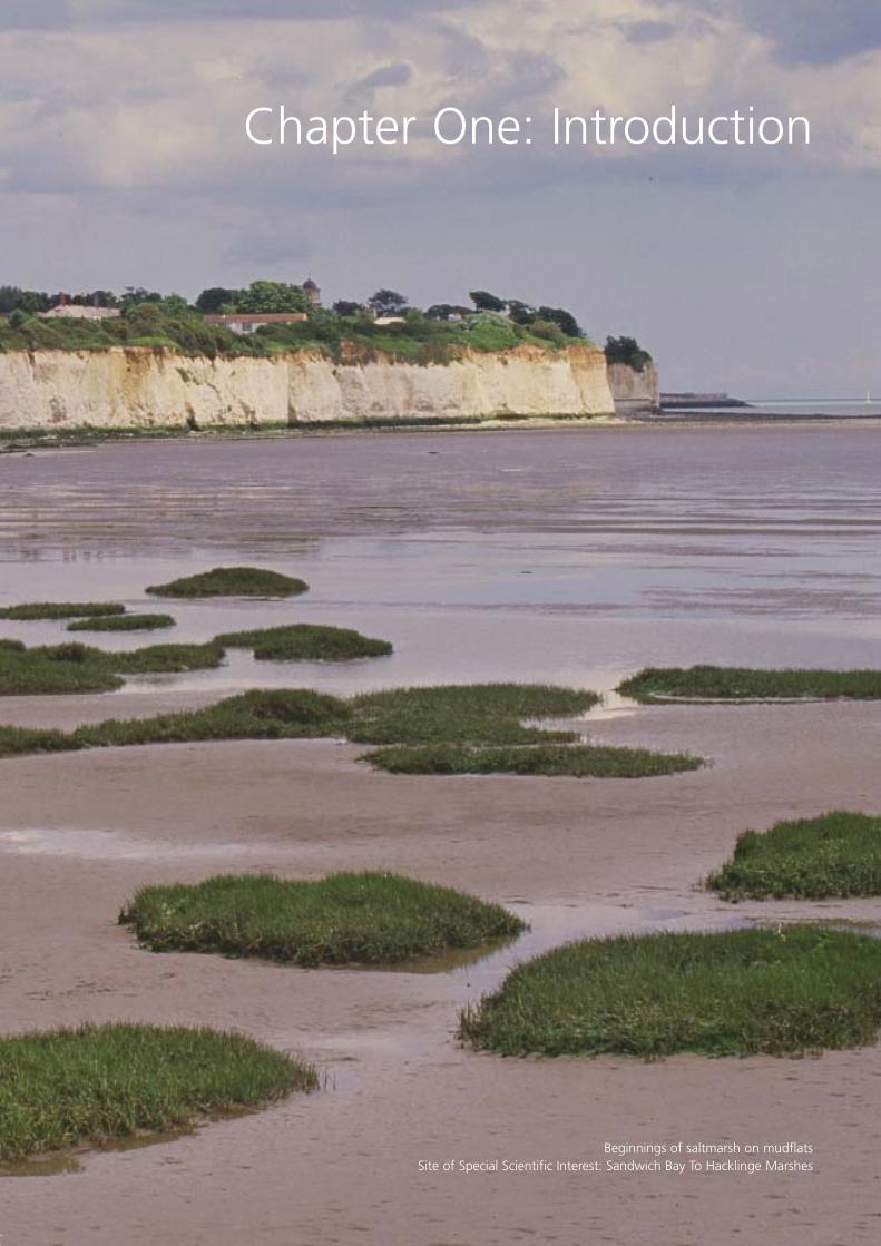
Plate 5: Beginnings of saltmarsh on mudflats 3Site of Special Scientific Interest: Sandwich Bay To Hacklinge MarshesNational Nature Reserve: Sandwich And Pegwell Bay, KentPhotographer: Paul Glendell, 2000
Plate 6: Eroding cliff at Plasterwine 10Site of Special Scientific Interest: Severn Estuary, GloucestershirePhotographer: Peter Wakely, 1994, © Natural England
Plate 7: Lincshore Beach Recharge Scheme, Lincolnshire; 22© Environment Agency
Plate 8: Site of Special Scientific Interest: Chesil & The Fleet; Dorset 32Photographer: Peter Wakely, 1991, © Natural England
Chapter One: Introduction
Beginnings of saltmarsh on mudflatsSite of Special Scientific Interest: Sandwich Bay To Hacklinge Marshes
4
1.1 SMP guidance documents
This document is the first of two volumes providing guidance on producing shorelinemanagement plans (SMPs). It is aimed at people responsible for defining and managing theproduction of SMPs and those carrying out work to produce these plans.
The volumes are as follows.
Volume 1: this defines an SMP and what it should include.
Volume 2: this provides guidance on how to produce an SMP in line with the requirements involume 1.
Volume 2 appendices: this is a CD-ROM of technical appendices supporting the approachesrecommended in volume 2. It sets out methods to help in producing an SMP, including examplesof some of the methods used when developing this guidance.
Volume 1 updates the 2001 guide for coastal defence authorities. It takes account of Futurecoastand the findings of the guidance project carried out between 2002 and 2004 (including three‘pilot’ shoreline management plans). See www.defra.gov.uk/environ/fcd/policy/smp.htm formore details.
We have developed volume 2 using industry-wide expertise to find the most appropriate best-practice methods for delivering the SMPs. In 2003, we consulted on the draft guidance and havenow amended it after considering the responses and the three ‘pilot’ shoreline management plans.
There is a glossary at the end of this volume to explain some of the terms we use.
1.2 Background
A shoreline management plan (SMP) is a large-scale assessment of the risks associated withcoastal processes (see the glossary) and helps to reduce these risks to people and the developed,historic and natural environment. In doing so, it is an important part of our and the WelshAssembly Government’s strategy for managing flooding and coastal erosion. The strategy aimsto manage risks (see box A on page 5) by using a range of methods which reflect both nationaland local priorities, to:
• reduce the threat of flooding and erosion to people and their property; and
• benefit the environment, society and the economy as far as possible, in line with theGovernment’s ‘sustainable development principles’ (see the glossary).
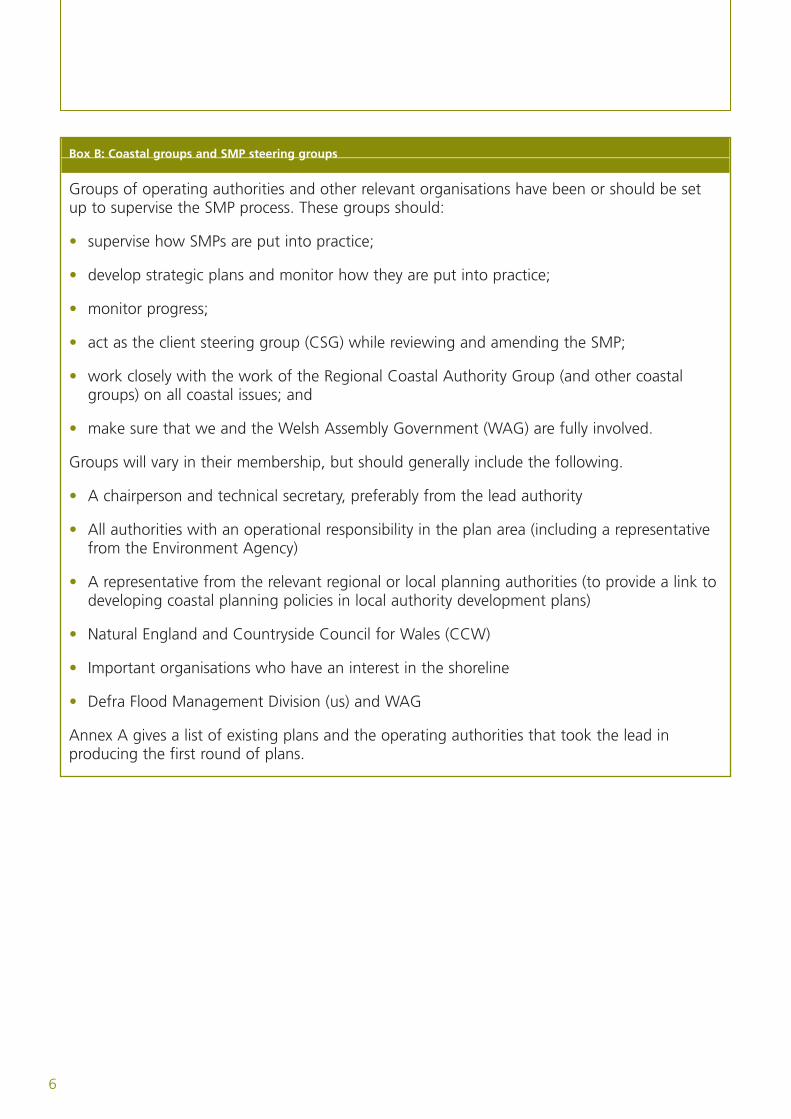
In 1995, the former Ministry of Agriculture, Fisheries and Food (MAFF) and the Welsh Officepublished guidance for operating authorities (such as maritime local authorities, the EnvironmentAgency and internal drainage boards) on preparing SMPs. It was often necessary for theseoperating authorities to work with neighbouring authorities, as voluntary coastal groups, toproduce an SMP which covered a number of administrative boundaries. In all cases, oneoperating authority was named as a lead authority to have overall responsibility for producingthe SMP (see box B on page 6).
5
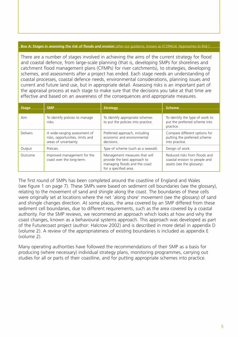
Box A: Stages in assessing the risk of floods and erosion (after our guidance, known as FCDPAG4 ‘Approaches to Risk’)
There are a number of stages involved in achieving the aims of the current strategy for floodand coastal defence, from large-scale planning (that is, developing SMPs for shorelines andcatchment flood management plans (CFMPs) for river catchments), to strategies, developingschemes, and assessments after a project has ended. Each stage needs an understanding ofcoastal processes, coastal defence needs, environmental considerations, planning issues andcurrent and future land use, but in appropriate detail. Assessing risks is an important part ofthe appraisal process at each stage to make sure that the decisions you take at that time areeffective and based on an awareness of the consequences and appropriate measures.
Stage SMP Strategy Scheme
Aim To identify policies to manage To identify appropriate schemes To identify the type of work to risks. to put the policies into practice. put the preferred scheme into
practice.
Delivers A wide-ranging assessment of Preferred approach, including Compare different options for risks, opportunities, limits and economic and environmental putting the preferred scheme areas of uncertainty. decisions. into practice.
Output Policies. Type of scheme (such as a seawall). Design of work.
Outcome Improved management for the Management measures that will Reduced risks from floods and coast over the long-term. provide the best approach to coastal erosion to people and
managing floods and the coast assets (see the glossary).for a specified area.
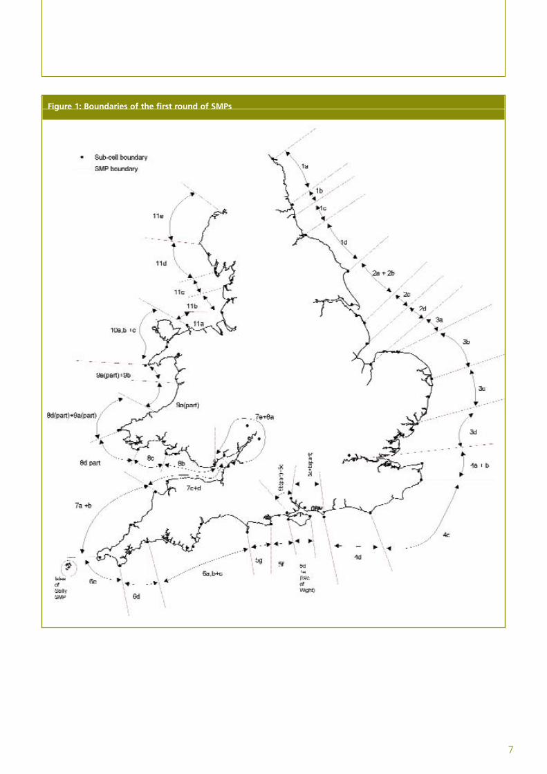
The first round of SMPs has been completed around the coastline of England and Wales(see figure 1 on page 7). These SMPs were based on sediment cell boundaries (see the glossary),relating to the movement of sand and shingle along the coast. The boundaries of these cellswere originally set at locations where the net ‘along shore’ movement (see the glossary) of sandand shingle changes direction. At some places, the area covered by an SMP differed from thesesediment cell boundaries, due to different requirements, such as the area covered by a coastalauthority. For the SMP reviews, we recommend an approach which looks at how and why thecoast changes, known as a behavioural systems approach. This approach was developed as partof the Futurecoast project (author: Halcrow 2002) and is described in more detail in appendix D(volume 2). A review of the appropriateness of existing boundaries is included as appendix E(volume 2).
Many operating authorities have followed the recommendations of their SMP as a basis forproducing (where necessary) individual strategy plans, monitoring programmes, carrying outstudies for all or parts of their coastline, and for putting appropriate schemes into practice.
6
Box B: Coastal groups and SMP steering groups
Groups of operating authorities and other relevant organisations have been or should be setup to supervise the SMP process. These groups should:
• supervise how SMPs are put into practice;
• develop strategic plans and monitor how they are put into practice;
• monitor progress;
• act as the client steering group (CSG) while reviewing and amending the SMP;
• work closely with the work of the Regional Coastal Authority Group (and other coastalgroups) on all coastal issues; and
• make sure that we and the Welsh Assembly Government (WAG) are fully involved.
Groups will vary in their membership, but should generally include the following.
• A chairperson and technical secretary, preferably from the lead authority
• All authorities with an operational responsibility in the plan area (including a representativefrom the Environment Agency)
• A representative from the relevant regional or local planning authorities (to provide a link todeveloping coastal planning policies in local authority development plans)
• Natural England and Countryside Council for Wales (CCW)
• Important organisations who have an interest in the shoreline
• Defra Flood Management Division (us) and WAG
Annex A gives a list of existing plans and the operating authorities that took the lead inproducing the first round of plans.
7
Figure 1: Boundaries of the first round of SMPs
8
1.3 Lessons learnt and revised guidance
In 2001, we produced ‘Shoreline management plans: A guide for coastal defence authorities’following a review of the strengths and weaknesses of the first round of SMPs in 2000. The 2001guide took account of the lessons we learnt from the first round of SMPs. This identified a seriesof changed requirements and considerations for producing the next plans, as well as providing theaims and ambitions for future SMPs. We then produced guidance to explain the methods toachieve these aims and ambitions. When developing the guidance, we further improved thecontent of the 2001 guidance, which reflected new information (such as Futurecoast, CoastalHabitat Management Plans (CHaMPs), the MAGIC website (a web-based map which bringstogether information on key environmental schemes) or new requirements (such as looking atmanaging risks from flooding and erosion over a longer time period, such as 100 years). As aresult, this document is an update of the 2001 guide for local defence authorities.
Through setting high-level targets (see the glossary), we are encouraging people to producefuture SMPs around the coastline of England and Wales. As a result, this document is aimedmainly at the operating authorities and their technical advisers. It will also be useful to otherorganisations with coastal interests, including local planning authorities and conservation groups.
This guide includes the main messages from the 12 advisory notes produced by the SMP AdvisoryGroup in 1998. You should also read the series of Flood and Coastal Defence Project AppraisalGuidance (FCDPAG) documents (Defra 1999 to 2004) and especially FCDPAG2 ‘StrategicPlanning and Appraisal’.
Future SMPs should build on the first round of plans, taking account of information collected orchanging circumstances. This guidance reflects the lessons we have learnt from the first round ofplans and three second-round ‘pilot’ SMPs carried out as part of developing the guidance, andstresses the following important issues.
• A clear focus on assessing and managing flooding risks and coastal erosion over a consistenttimescale (100 years).
• Recognition that the current SMP policy may no longer be practical or acceptable in thefuture. In these circumstances, the preferred policy should include a plan for moving from thecurrent SMP to another policy.
• Awareness of the longer-term implications (50 to 100 years) of coastal change, climatechange and rises in sea levels.
• Awareness of the uncertainties associated with predicting future requirements for managingthe shoreline.
• Mapping coastal risks, covering risks from flooding and erosion.
• More efficient and focused consultation, with stakeholders invited to comment on preferredpolicies (see the glossary) and their likely consequences. The adopted policies should takeaccount of all the comments received. If the adopted policies are different from the preferredpolicies, you must clearly give the reasons and consequences.
• The importance of guiding and supporting the planning system in discouraging inappropriatedevelopment in areas at risk from flooding or coastal erosion.
• Considering estuaries within the SMP process and links with the catchment floodmanagement plan process.
• Identifying the consequences of adopting particular policies, in appropriate detail. This shouldinvolve, among other things, assessing the implications of policies on European sites,biodiversity objectives (see the glossary) and other national targets and objectives relating tothe natural and cultural environment.
• Identifying the expected sources of funding for any coastal defence work or operations thatmight be needed to put the adopted policies into practice.
• The value of a standard format for plans.
• The value of providing the plan on CD-ROMs and the internet, although you may need todeal with copyright issues.
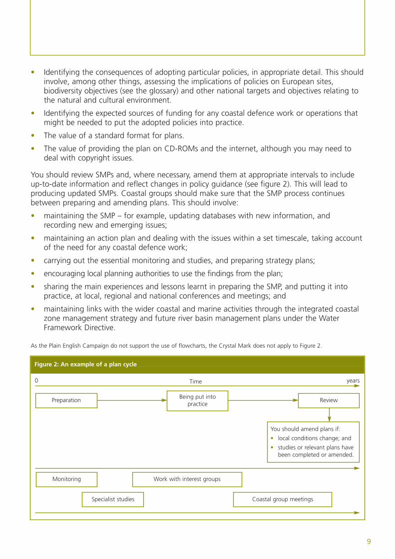
You should review SMPs and, where necessary, amend them at appropriate intervals to includeup-to-date information and reflect changes in policy guidance (see figure 2). This will lead toproducing updated SMPs. Coastal groups should make sure that the SMP process continuesbetween preparing and amending plans. This should involve:
• maintaining the SMP – for example, updating databases with new information, andrecording new and emerging issues;
• maintaining an action plan and dealing with the issues within a set timescale, taking accountof the need for any coastal defence work;
• carrying out the essential monitoring and studies, and preparing strategy plans;
• encouraging local planning authorities to use the findings from the plan;
• sharing the main experiences and lessons learnt in preparing the SMP, and putting it intopractice, at local, regional and national conferences and meetings; and
• maintaining links with the wider coastal and marine activities through the integrated coastalzone management strategy and future river basin management plans under the WaterFramework Directive.
As the Plain English Campaign do not support the use of flowcharts, the Crystal Mark does not apply to Figure 2.
Figure 2: An example of a plan cycle
9
0 yearsTime
Preparation Being put intopractice
Review
You should amend plans if:
• local conditions change; and
• studies or relevant plans havebeen completed or amended.
Monitoring
Specialist studies
Work with interest groups
Coastal group meetings
Chapter Two:Objectives and general principles
Eroding cliff at PlasterwineSite of Special Scientific Interest: Severn Estuary
11
Shorelines constantly change due to waves and tides. The amount of physical change dependson many things, and happens over timescales from seconds to centuries. The changing coastlinehas also been influenced by people’s actions throughout the years, particularly in attempts tostop the effect of erosion or flooding. In some cases, this has taken place without anappreciation of the effect these actions could have on other places up and down the coast.
Although these changes continue, social, economic and environmental pressures are increasing inthe coastal area. People enjoy living by and visiting the coast, and the pressure for more housingis increasing. As international trade increases, so does the demand for port space and associatedcoastal-based industry. This sort of development places stress on natural coastal habitats that areoften unique and of national and international importance.
2.1 Objectives
An SMP should provide the basis for policies for a length of coast and set the framework formanaging risks along the coastline in the future.
The objectives of an SMP need to be in line with the Government’s strategy (Defra 2005) formanaging risks from floods and coastal erosion (also see our website:www.defra.gov.uk/environ/fcd/policy/strategy.htm) and should:
• set out the risks from flooding and erosion to people and the developed, historic and naturalenvironment within the SMP area;
• identify opportunities to maintain and improve the environment by managing the risks fromfloods and coastal erosion;
• identify the preferred policies for managing risks from floods and erosion over the next century;
• identify the consequences of putting the preferred policies into practice;
• set out procedures for monitoring how effective these policies are;
• inform others so that future land use, planning and development of the shoreline takes accountof the risks and the preferred policies;
• discourage inappropriate development in areas where the flood and erosion risks are high; and
• meet international and national nature conservation legislation and aim to achieve thebiodiversity objectives (see the glossary).
2.2 General principles
An SMP should identify the best approach or approaches to managing risks over the next 100years from flooding and coastal erosion (including cliff instability) both for individual areas andthe wider coast. The plan should set out whether to defend (or continue to defend) assets (seethe glossary) with coastal defences or manage the risks in other ways. It should be based on anassessment of conditions in the plan area (and, where appropriate, neighbouring plan areas)rather than detailed studies of individual sites.
Previous SMPs developed ‘coastal process units’ and ‘management units’ (which are defined in theglossary) to describe recommended policies, but these will be replaced by ‘policy units’ which may
12
not match the original boundaries. Policy units are simply lengths of shoreline for which a separateshoreline management policy applies. These should be divided, as necessary, to reflect changes inpolicy over time and significant differences in policy implications. We do not expect policy units tobe defined until the policy development stage of SMP reviews (see volume 2, stage 3).
‘Sustainable’ shoreline management policies will be those which take account of the relationshipswith other defences, developments and processes, and which avoid, as far as possible, committingfuture generations to inflexible and expensive options for defence. Putting the policies intopractice should benefit stakeholders and help to improve the environment both nationally andlocally. This will not always be possible, but should be an important goal of the SMP.
Decisions should be based on a good understanding of coastal processes and how they affectexisting coastal defences and assets. However, this will not always be the case as there may be alack of understanding of processes in some areas. In these cases, a wide-ranging approach whichhighlights the main things that will influence policy selection can be valuable.
Each length of shoreline is currently managed in a particular way (the current SMP policy).However, for various reasons this policy may no longer be practical or acceptable at some timeover the next 100 years. For example:
• the current management approach may not be appropriate for managing existing risks;
• the current defences may have a limited life and improvements may not be economically,technically or environmentally practical; and
• changes in the shoreline may result in new approaches being necessary to manage futurerisks to the developed, historic and natural environment.
As a result, an SMP should identify the combination of policies that are likely to be practical andacceptable over the next 100 years. This may involve continuing to put the current policy intopractice or putting another policy into practice at some time within the next 100 years. Youshould clearly identify the operations and management activities needed to achieve this changeand set out an estimated timetable. This preferred order of management approaches is theshoreline management plan. The SMP must also guide and support the planning system indiscouraging inappropriate development in areas at risk from flooding and coastal erosion.
The timing of any change in shoreline management policy, in most cases, cannot be defined precisely.However, it will usually reflect a combination of technical, social, economic and environmental factorsthat may change over time. The move from the current policy to another policy will need planningand discussion with a range of interested people (landowners, occupiers, businesses, the localplanning authority and conservation groups). This should allow in-depth discussions to take placewith the relevant people so that you can identify and deal with possible conflicts.
Solutions for current and future problems must take place over the long-term. For this reason,your SMP should clearly define the implications of longer-term coastal change (more than 50 to100 years) for managing the shoreline. This is particularly important where the scale of predictedcoastal changes means that current approaches to reducing risk may no longer be practical atsome time in the future. In doing so, SMPs can begin to let policy-makers and the public knowabout the need for longer-term solutions to natural coastal change, climate change and a rise insea levels. In many cases we expect that achieving the long-term plan will depend on spatialplanning (see the glossary) to put into practice necessary changes in the way the coast is used.
At a time when the country is having to increase the number of houses available, planningarrangements may need to be made to make up for any losses of land set aside for residentialdevelopment that will result from the SMP (for example, by making other land available forbuilding). Regional planning initiatives will need to consider shoreline management policies andmake sure that future proposals and investment for regional development take account of risksfrom floods and erosion.
Local authorities should consider the risks identified in SMPs. Before approving development inareas at risk of flooding and erosion, they should take account of any long-term coastal changeidentified in the SMP.
The SMP will also provide useful information for private land and property owners who will needto consider how they will deal with these changes. Operating authorities, local government andnational government do not have a duty to provide protection against flooding or erosion. Nor isthere any reason to assume that this will change in the future or that individual losses would becompensated for from public funds. However, operating authorities should work with otherrelevant authorities and the Government to assess the effects and promote communityconfidence where new (or improved defences) cannot be provided in the future.
2.3 Managing risks: shoreline management policies
Managing the shoreline involves identifying the best ways to manage risks to people and thedeveloped, historic and natural environment, and how to put these into practice. A range ofresponses is available for managing risks (see FCDPAG4 ‘Approaches to Risk’), including:
• removing risks by avoiding or moving inappropriate development in vulnerable areas (such asthrough planning how land is used);
• reducing the likelihood of damaging events through management work that preventsdamage (such as managing beaches, cliffs, dunes, saltmarshes and so on) or using back-upand secondary defence systems (such as for tidal defence);
• reducing the consequences of risks by providing early-warning systems (such as floodwarning systems operated by the Environment Agency); and
• reducing the risks associated with potentially damaging events through flood and coastaldefence schemes or altering buildings to reduce the chance of flood damage.
The most appropriate measures will depend on the problem, and on technical, environmental,social and economic circumstances. Some of these approaches are not covered by shorelinemanagement. However, in many cases the response will involve a combination of measuresincluding, for example, working with local planning authorities to achieve the same objectives.
Below are the four SMP policies available to shoreline managers.
• Hold the existing defence line by maintaining or changing the standard of protection.This policy should cover those situations where work or operations are carried out in front ofthe existing defences (such as beach recharge (see the glossary), rebuilding the toe of astructure, building offshore breakwaters and so on) to improve or maintain the standard ofprotection provided by the existing defence line. You should include in this policy other
13
14
policies that involve operations to the back of existing defences (such as building secondaryfloodwalls) where they form an essential part of maintaining the current coastal defencesystem.
• Advance the existing defence line by building new defences on the seaward side of theoriginal defences. Using this policy should be limited to those policy units where significantland reclamation is considered.
• Managed realignment by allowing the shoreline to move backwards or forwards, withmanagement to control or limit movement (such as reducing erosion or building newdefences on the landward side of the original defences).
• No active intervention, where there is no investment in coastal defences or operations.
Note: All the policies above will need to be supported by monitoring and must (when put intopractice) take account of existing health and safety legislation.
In some cases, it is more appropriate to consider the defence line as a zone of defencesprotecting assets, particularly in those situations where there is a series of structures (such asseawalls) and landforms (such as beaches and dunes) which together provide coastal defence.Adding new components to this series of defences should generally be viewed as improving thedefence, rather than moving the shoreline.
By working with natural processes (such as tides and the weather), you can reduce risks whileallowing natural coastal change. This may range from measures which try to slow down ratherthan stop coastal and cliff erosion, to measures that deal with public safety issues (such aspromoting the build-up of a beach in front of an unprotected cliff, preventing water from leakingonto coastal slopes, and flood warning systems).
We want to highlight the importance of existing natural defences (such as sand dunes,saltmarshes and shingle ridges) in delivering effective policies to manage coastal and flood risks.If these are under threat due to fixed defence structures, you should consider measures to restoreor recreate natural defences.
In other cases, you might take measures to maintain the natural standard of defence onshorelines that are increasing (for example, by managing areas of erosion along sand dunes).If appropriate, these measures will be the preferred policy approach.
2.4 Policy appraisal
When choosing policies, you need to take account of technical, environmental, social andeconomic factors, in line with the Government’s strategy for managing floods and coastalerosion. However, you also need to consider local factors when deciding how these policies aremost appropriate to particular areas and circumstances. Despite this, it is essential that thepolicies in the SMP are realistic, using existing legislation and likely future funding. A plan thathas long-term policies should not be driven by short-term objectives. Although the plan shouldbe flexible enough to adapt to changes in legislation, politics and social attitudes, you shoulddevelop the SMP policies based on current legislation.
To identify and take account of these factors, assessing and choosing policies should include thefollowing steps.
• Identifying a preferred plan (being the most sustainable – that is, avoiding tying futuregenerations into inflexible or expensive options for defence). Appropriate policies for eachpolicy unit will be based on an analysis of the available information, taking account oftechnical, environmental, social and economic factors.
• Interested people examining these policies.
• Adopting the SMP and associated policies after considering all comments and responses frompeople who were consulted, which may result in the adopted policy being different from thepreferred policy.
If technical, environmental, social and economic factors do not support the adopted policy, it isimportant that this is clearly shown in the plan. If there are significant uncertainties about futureconditions, you will need to identify the studies that would be needed to deal with theoutstanding issues. The aim is that, by the next SMP, any existing uncertainties will be solved sothat it is possible to define a single policy for each unit (for each time period), rather thanoffering alternatives.
You should not automatically adopt the policy of holding the existing defence line. You shouldthoroughly assess and compare other policies, including a broad assessment of the longer-termcosts and the effects on natural processes (including, for example, pressures on regional demandsfor sand and gravel). You should consider technical, environmental, social and economicrequirements, including whether the policy is practical in the long term.
Individuals and some private organisations have rights or powers to protect their own property,although under existing laws permission is needed before work can be carried out. On manycoasts there are lengths of coastal defences that are privately owned and maintained. SMPs willhelp you to understand the relationship between any private defences and the risks elsewhere(for example, the wider community). This will provide evidence for authorities when consideringany application to introduce new or amended defences.
When assessing policies for particular policy units (see the glossary), you will need to takeaccount of the relationship with other parts of the coast and give equal consideration toachieving requirements in those areas.
Policies for units will need to consider the following.
• The effects of coastal processes throughout the SMP (or within a coastal process unit wherethese can be defined).
• The possible effect of the policies on coastal processes elsewhere in the SMP area or, whererelevant, outside the SMP area.
The SMP will be made up of a number of policy units (see the glossary) which are developedfrom a combination of policies for any changes over time at each location. When assessingpolicies, you will need to consider the implications of different combinations of policies on anylinked shorelines, and their proposed policies, for all three epochs (see the glossary) (see tasks 3.1and 3.2, volume 2).
15
16
2.5 Involving and consulting people
The approach you use for involving people will depend on the SMP you are developing. Volume2 (task 1.3 and appendix A) provides guidance on the type of approaches and techniques youcould use. Your SMP should include full details of the approach you are using, including detailsof who you have consulted, the responses you have received and the actions you have taken.This is necessary to show that you have carried out consultation effectively.
Whichever approach you use, you should consult people at least during the following mainstages in developing your SMP.
Stage 1
You should contact all stakeholders to:
• let them know that you are preparing an SMP and make them more aware of the SMP’s aimsand objectives;
• ask for relevant information so that they are involved in the project as far as possible; and
• identify the main stakeholders and other people you can consult.
Stages 2 and 3
You should involve stakeholders (including councillors and regional flood defence committees) to:
• make sure all the information you use is correct;
• make them more aware of coastal change and risks; and
• make sure that representatives of interested people have an opportunity to tell you theirideas, opinions and concerns.
Stage 4
You should consult your stakeholders and the general public to:
• let them know that you have prepared an SMP; and
• give them the opportunity to support or object to the proposals.
Stage 5
You should contact councillors, regional flood defence committees, planners and so on to:
• let them know about proposed changes to the final SMP (based on consultation responses);and
• request that they adopt the SMP.
Stage 6
You should make the general public and everyone you have consulted aware of:
• where they can see a copy of the adopted SMP; and
• how you are putting the agreed actions into practice.
You should include in your SMP full details of the methods you used, including the people youconsulted, the responses you received and the actions you have taken.
This is necessary to show that the consultation you carried out has been effective, and that thedecisions you have made are transparent and auditable (see below), so that interested peoplecan understand why a decision has been made and what information it is based on. In line withgood practice, throughout the consultation process you should give stakeholders and the generalpublic an opportunity to let you know what they think about the policy options. You shouldclearly describe the environmental consequences of other policies in the consultation draft plan,and consider comments before you adopt a policy. In the final SMP document, you should clearlyexplain the reasons for choosing the preferred option as well as its environmental effects.
You should use different types of communication (such as local consultation meetings andseminars, non-technical public-relations leaflets, newsletters to households, summary documents,public exhibitions and adverts in the press) depending on the target audience and the type ofinformation. Local authorities and the Environment Agency should use their experience in publicconsultation to make sure the public is fully and suitably involved in developing the plan. Whenconsidering the type of consultation and involvement that is appropriate, the following threepoints are important.
• ‘Transparency and auditability’, so that interested people can understand why a decision hasbeen made and what information it is based on.
• Clear explanations of the terminology.
• What the shoreline management policy will cover and the rights people have to influence it.
2.6 Influencing the planning process on how land is used
It is important to avoid placing extra responsibility on future generations by unnecessarilyincreasing the number of areas needing to be protected. Although regulating how land isdeveloped and used is the responsibility of the planning system (see box C on page 18), the needto reduce risks to people and the developed, historic and natural environment is a sharedobjective. So too is the need to avoid damage to European sites (see the glossary) and identifyopportunities for protecting and improving the environment. An SMP should give peopleinvolved in planning information on coastal risks and the preferred approaches for managing theshoreline. This information will help to make sure that:
• future development does not take place in unsuitable areas at risk from flooding, coastalerosion and cliff instability;
• development is restricted in possible areas of managed realignment (see the glossary); and
• development does not affect the natural balance of the coastline, to the extent that erosion iscaused elsewhere or that further or improved coastal defences have to be built and maintained.
17
18
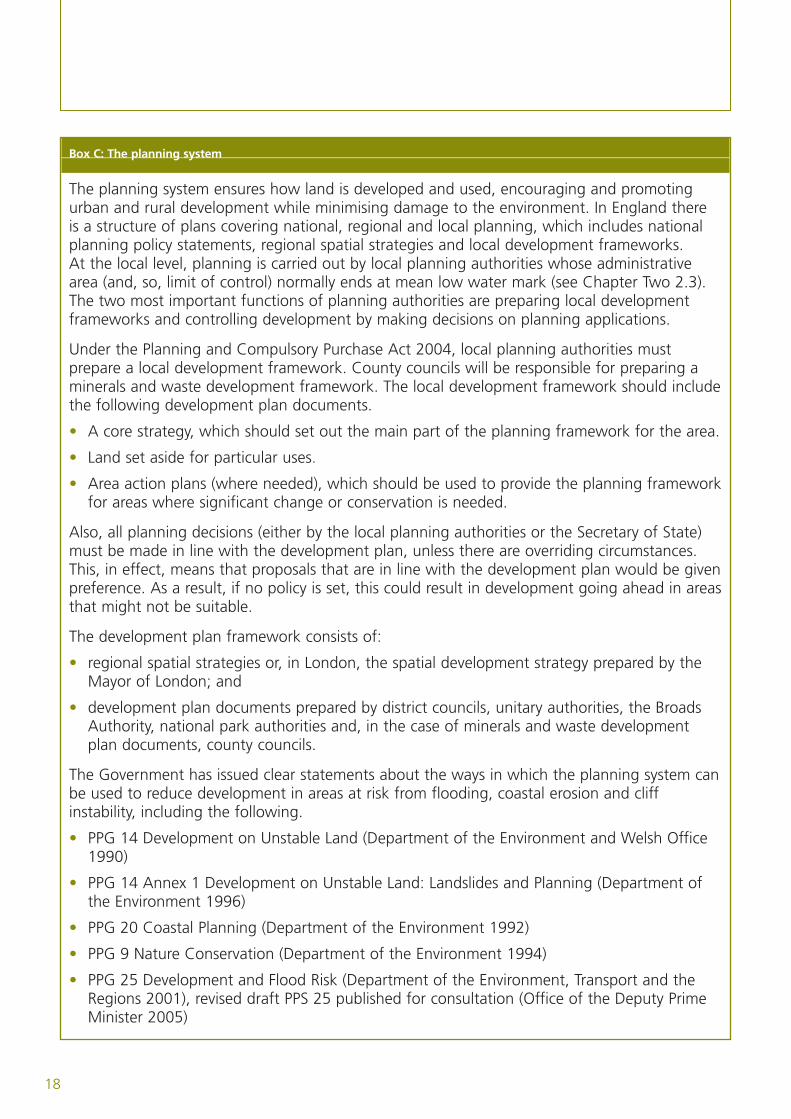
Box C: The planning system
The planning system ensures how land is developed and used, encouraging and promotingurban and rural development while minimising damage to the environment. In England thereis a structure of plans covering national, regional and local planning, which includes nationalplanning policy statements, regional spatial strategies and local development frameworks.At the local level, planning is carried out by local planning authorities whose administrativearea (and, so, limit of control) normally ends at mean low water mark (see Chapter Two 2.3).The two most important functions of planning authorities are preparing local developmentframeworks and controlling development by making decisions on planning applications.
Under the Planning and Compulsory Purchase Act 2004, local planning authorities mustprepare a local development framework. County councils will be responsible for preparing aminerals and waste development framework. The local development framework should includethe following development plan documents.
• A core strategy, which should set out the main part of the planning framework for the area.
• Land set aside for particular uses.
• Area action plans (where needed), which should be used to provide the planning frameworkfor areas where significant change or conservation is needed.
Also, all planning decisions (either by the local planning authorities or the Secretary of State)must be made in line with the development plan, unless there are overriding circumstances.This, in effect, means that proposals that are in line with the development plan would be givenpreference. As a result, if no policy is set, this could result in development going ahead in areasthat might not be suitable.
The development plan framework consists of:
• regional spatial strategies or, in London, the spatial development strategy prepared by theMayor of London; and
• development plan documents prepared by district councils, unitary authorities, the BroadsAuthority, national park authorities and, in the case of minerals and waste developmentplan documents, county councils.
The Government has issued clear statements about the ways in which the planning system canbe used to reduce development in areas at risk from flooding, coastal erosion and cliffinstability, including the following.
• PPG 14 Development on Unstable Land (Department of the Environment and Welsh Office1990)
• PPG 14 Annex 1 Development on Unstable Land: Landslides and Planning (Department ofthe Environment 1996)
• PPG 20 Coastal Planning (Department of the Environment 1992)
• PPG 9 Nature Conservation (Department of the Environment 1994)
• PPG 25 Development and Flood Risk (Department of the Environment, Transport and theRegions 2001), revised draft PPS 25 published for consultation (Office of the Deputy PrimeMinister 2005)
19
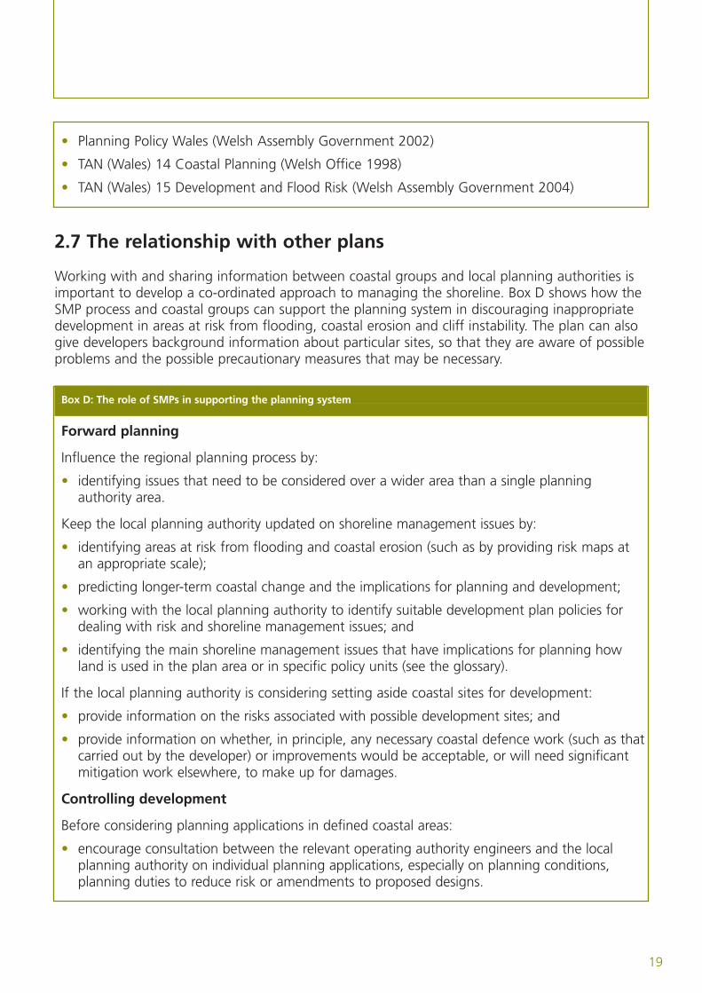
• Planning Policy Wales (Welsh Assembly Government 2002)
• TAN (Wales) 14 Coastal Planning (Welsh Office 1998)
• TAN (Wales) 15 Development and Flood Risk (Welsh Assembly Government 2004)
2.7 The relationship with other plans
Working with and sharing information between coastal groups and local planning authorities isimportant to develop a co-ordinated approach to managing the shoreline. Box D shows how theSMP process and coastal groups can support the planning system in discouraging inappropriatedevelopment in areas at risk from flooding, coastal erosion and cliff instability. The plan can alsogive developers background information about particular sites, so that they are aware of possibleproblems and the possible precautionary measures that may be necessary.
Box D: The role of SMPs in supporting the planning system
Forward planning
Influence the regional planning process by:
• identifying issues that need to be considered over a wider area than a single planningauthority area.
Keep the local planning authority updated on shoreline management issues by:
• identifying areas at risk from flooding and coastal erosion (such as by providing risk maps atan appropriate scale);
• predicting longer-term coastal change and the implications for planning and development;
• working with the local planning authority to identify suitable development plan policies fordealing with risk and shoreline management issues; and
• identifying the main shoreline management issues that have implications for planning howland is used in the plan area or in specific policy units (see the glossary).
If the local planning authority is considering setting aside coastal sites for development:
• provide information on the risks associated with possible development sites; and
• provide information on whether, in principle, any necessary coastal defence work (such as thatcarried out by the developer) or improvements would be acceptable, or will need significantmitigation work elsewhere, to make up for damages.
Controlling development
Before considering planning applications in defined coastal areas:
• encourage consultation between the relevant operating authority engineers and the localplanning authority on individual planning applications, especially on planning conditions,planning duties to reduce risk or amendments to proposed designs.
Due to the complex nature of coastal regions, a wide range of management plans and strategieshave been developed to work towards achieving the aim of sustainable management (see theglossary).
Although the relationship between these plans can be complicated, they should influence andreinforce each other and provide frameworks for putting the SMP into practice, includingachieving economic, social and environmental objectives. SMPs can support other coastal andestuary management plans, including integrated coastal zone plans (ICZM)(www.defra.gov.uk/environment/marine/iczm/index.htm) by providing information on theexpected coastal changes, coastal risks and the preferred approaches for managing the shoreline.
SMPs will be one of several non-statutory plans (that is, not needed by law) supporting riverbasin management plans (RBMPs) needed under the EU Water Framework Directive. Thoseresponsible for other plans will need to be told about SMPs and be appropriately involved indeveloping them, to identify appropriate actions that contribute to the programme of measureswithin RBMPs. You can find more information on the Water Framework Directive, and RBMPs, onour website at www.defra.gov.uk/environment/water/wfd/index.htm.
2.8 The main inputs and outputs
One of the main aims of an SMP is to promote sustainable policies into the next century andprovide a timescale for managing risks along the coastline in the future. This will be achievedthrough inputs and outputs.
The main inputs into the SMP
• Up-to-date information and changes in policy guidance and ongoing changes in theshoreline.
• Assessing the risks to people and the developed, historic and natural environment in the SMParea.
• Considering stakeholders’ objectives and other planning policies.
• Better understanding of coastal processes and movement of mud, sand and gravel, includingreviewing Futurecoast predictions.
• Developing policies that achieve both short-term and long-term objectives withoutcommitting to defences that will not be effective.
• Identifying the consequences of putting policies into practice, through considering long-termshoreline response (see the glossary) and change.
The main outputs from the SMP
• A non-technical explanation which gives background information on developing the plan anddiscusses sustainable management (see the glossary).
• Policy statements for each policy unit, outlining:
– details of the policies for each time period and how they will be put into practice;
– justification for the policies; and
20
– implications for local objectives (including identifying and mapping areas of the coast thatwill be at risk from flooding or erosion).
• A realistic and affordable action plan for putting the SMP into practice.
• A record of issues and objectives, and how they have been assessed as part of the policydevelopment process.
• All background information used in developing the plan, including the shoreline responseassessment and identifying features and issues along the coast.
• Records of how stakeholders have been involved throughout the SMP development.
This will make sure that the SMP process is transparent and auditable, so that it is clear how andwhy decisions have been made.
21
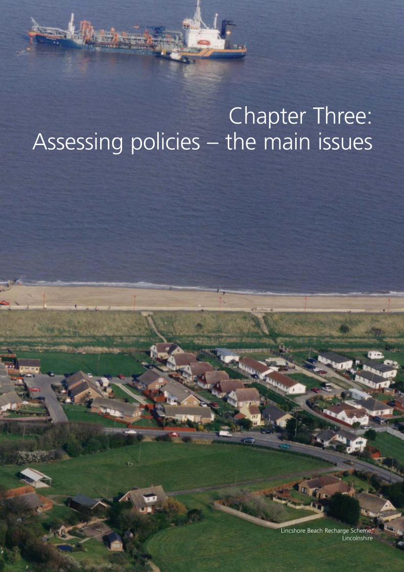
Chapter Three:Assessing policies – the main issues
Lincshore Beach Recharge Scheme,Lincolnshire
23
You need to deal with the following five main issues when assessing shoreline management policies.
• Coastal defences, including the purpose of and responsibility for defences, the condition,performance and ‘residual life’ (see the glossary) of existing defences, and other relatedfactors such as the availability of beach recharge material (see the glossary) to meet currentand future needs, and the costs of defending in the future.
• How land is used, including coastal communities and social and economic assets, current andfuture development proposals, agricultural and forestry issues, ports and harbour operations,dredging operations (removing sand and gravel from the seabed), recreation and tourism.
• Historic and archaeological features recorded in historic environment records and areas ofhigh archaeological potential, including maritime archaeological features, scheduledmonuments (see the glossary), listed buildings and registered battlefields.
• Landscape, including areas protected for their landscape importance such as national parks,areas of outstanding natural beauty and the heritage coast (see the glossary).
• The natural environment, including the implications of the Conservation (Natural Habitats& c.) Regulations 1994 and biodiversity targets (see the glossary), and other relevantgovernment targets, such as the public service agreement (PSA) target to bring 95% of allSites of Special Scientific Interest (SSSIs) into favourable condition by 2010 (as defined byNatural England on their website).
An understanding of coastal processes is essential for assessing all of the issues above and is animportant part of the process of developing the SMP.
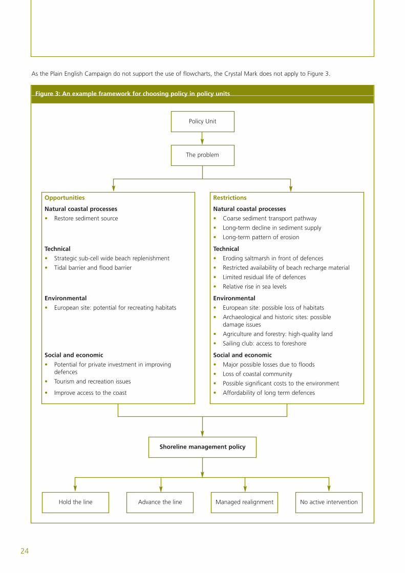
These issues provide a framework which influences the overall long-term approach to managingthe shoreline and the preferred policies for individual policy units (see figure 3 on page 24).The objectives for SMPs are in box E below.
Box E: Policy objectives
• Shoreline management policies should take account of current Government sustainabledevelopment policies, any high-level targets (see the glossary), regulations, statutes andclimate change guidelines associated with flood and coastal defence (framework objective).
• Shoreline management policies should aim to have no negative effect on any coastalprocesses (see the glossary) that assets rely on (technical objective).
• Shoreline management policies should take account of the need to maintain, restore or,where possible, improve natural and historic assets (environmental objective).
• Shoreline management policies should take account of current regional development agencyobjectives and statutory planning policies (social and economic objectives).
24
As the Plain English Campaign do not support the use of flowcharts, the Crystal Mark does not apply to Figure 3.
Figure 3: An example framework for choosing policy in policy units
Hold the line Advance the line No active interventionManaged realignment
Shoreline management policy
Policy Unit
The problem
Opportunities
Natural coastal processes
• Restore sediment source
Technical
• Strategic sub-cell wide beach replenishment
• Tidal barrier and flood barrier
Environmental
• European site: potential for recreating habitats
Social and economic
• Potential for private investment in improvingdefences
• Tourism and recreation issues
• Improve access to the coast
Restrictions
Natural coastal processes
• Coarse sediment transport pathway
• Long-term decline in sediment supply
• Long-term pattern of erosion
Technical
• Eroding saltmarsh in front of defences
• Restricted availability of beach recharge material
• Limited residual life of defences
• Relative rise in sea levels
Environmental
• European site: possible loss of habitats
• Archaeological and historic sites: possibledamage issues
• Agriculture and forestry: high-quality land
• Sailing club: access to foreshore
Social and economic
• Major possible losses due to floods
• Loss of coastal community
• Possible significant costs to the environment
• Affordability of long term defences
3.1 Coastal processes
One of the main requirements of managing shorelines effectively is knowledge of coastalprocesses in the area concerned. An understanding of the relationship between the coastalprocesses and coastal defence is essential. You need to consider:
• how the coastline changes; and
• existing information and studies on coastlines.
3.1a Managing shorelines
To make decisions on managing shorelines and planning how land is used, you need to makepredictions (or estimates) of long-term changes to the coastline. This is difficult due to thecomplexity of the natural coast and because changes take place at different timescales and overdifferent distances.
We recommend a ‘behavioural systems’ approach (see the glossary). This involves identifying thedifferent elements (such as cliffs, beaches, dunes and so on) that make up the coastalenvironment and how they affect each other. To help guide the SMPs, we and the WelshAssembly Government worked together in promoting Futurecoast (a coastal process study of thecoastline of England and Wales). As well as providing the SMPs with a vision of coastal change inthe longer-term, the research also promotes the behavioural systems approach as a way ofassessing changes in the shoreline, when looking at a number of policies. Appendix D (volume 2)provides further guidance on using this approach in updating SMPs.
You need to review all available information to develop an understanding of coastal processesand coastal changes at different scales. Annex D1 (volume 2) identifies the main sources ofinformation that should be used with the information provided by Futurecoast(author: Halcrow 2002).
The natural changes in the coast, together with the expected implications of climate change anda rise in sea levels (see box F on page 26), are a significant challenge to managing the shorelinein the future. We expect that there will be increased levels of risk to many coastal assets. In someplaces, current approaches to reducing risk will not be practical in the future. As a result, it isimportant that SMPs take account of expected changes in the coast and the implications forfuture management. In doing so, SMPs can begin to help keep policy-makers and the publicupdated on the need for longer-term management.
Past changes in the coastline can provide information that is valuable in developing theories onfuture change. Current coastal landforms have developed since the last ice age so you shouldconsider studies of changes since then. You can do this by studying existing landforms, historicalmaps, aerial photographs, archaeological records and other published and unpublished sources.
An understanding of the future changes will allow you to identify areas where managementproblems are likely to arise in the future. These areas could be:
• areas that will continue to change due to erosion or accretion (see the glossary);
• areas that will be increasingly at risk from flooding, erosion or instability;
25
26
• areas where maintaining existing defences is likely to become increasingly difficult orexpensive; and
• areas that will become increasingly important to the shoreline and coastal defences, such asinter-tidal flats providing protection from waves.
Identifying the areas likely to change in the long-term will help you to develop appropriatestrategies for the next 50 to 100 years.
Any study for the future of the coast needs a scientific basis for considering what policies theplan should cover and to what extent. Such studies should also include an assessment of howfuture climate change is likely to affect the coast.
Box F: Climate change and rising sea levels
The world’s climate is constantly changing. In recent years, concerns have been raised,particularly on rising sea levels but also changes in storminess and rainfall. The expectedimplications of climate change and rises in sea levels are a significant challenge to managingcoastlines in the future. As a result, the UK Climate Impacts Programme (UKCIP) has beendeveloping theories of possible change over the next century, with the most recent estimatesproduced in 2002 (authors: M Hulme and others 2002). For shoreline management, you canget guidance on appropriate allowances for future change from the Defra and EnvironmentAgency research and development report on using the UKCIP02 theories (produced in 2002).
The UK Government arranged a Foresight project (the report was produced in 2004), toprovide more information on flood and coastal defence. The project looked at flood andcoastal defence in the UK between 2030 and 2100, considering flooding from rivers and thesea, and the risks of coastal erosion. They used alternative theories to assess the possible scaleand nature of future risks, and to assess options for responding to those risks. These theoriestook account of different social and economic visions of the UK and different amounts ofclimate change. The future work of UKCIP may include more detailed climate predictions andmake specific efforts to predict possible changes in extreme conditions, such as storms. Weintend to provide further guidance specific to SMP studies and designing coastal defenceswhen the results of these and other research studies are available.
3.1b Existing coastal information and studies
Since the first round of SMPs was finished, many parts of the coast have been monitored orstudied to improve the level of knowledge of coastal processes, changes and landforms. You mayneed to analyse this information and take it into account when preparing future plans. Thefollowing are particularly important.
• Identifying areas at risk from flooding or coastal erosion.
• The relationships between neighbouring lengths of shoreline.
A lot of the information used in the SMP review will be from the existing SMP and any strategies,schemes and studies that have been put into practice since. We have identified a series ofnationally available information that is appropriate to developing SMPs. These are outlined involume 2 (task 1.4 and appendix B). Collecting appropriate information is a very important andoften time-consuming part of stage 1 of the SMP (volume 2, stage 1) and should be done earlyin the programme for updating an SMP.

27
3.2 Coastal defences
There are already coastal defences and other coastal structures (such as ports and harbours) onmany shorelines. It is important to assess how these defences affect coastal processes. Howeffective they are and their residual lives will affect future coastal changes. Many defences willneed major work in the future if existing defence standards are to be maintained or improved.
Operating authorities should make sure that a programme is in place for regularly inspecting alldefences. These surveys should provide up-to-date information on the location and type ofexisting defence structures, together with an assessment of their condition, performance andresidual life. Operating authorities should be recording this information in the national flood andcoastal defence database. SMP studies should use this database.
3.3 Current and future land use
The need for action to defend the coastline from flooding or coastal erosion arises from thelocation of many important residential, industrial, commercial, nature conservation andagricultural sites in the coastal zone. The communities and economy of coastal areas can behighly dependent on measures to reduce risks to people and their assets. When reviewing policy,the SMP must take full account of the possible implications of any change in coastal defence,both on the economic assets and the communities they support.
Government guidance has stressed that the policy for development in the coastal zone should beto avoid putting further development at risk – see Planning Policy Guidance (PPG) 20 CoastalPlanning (Department of Environment 1992), Planning Policy Wales, Technical Advice Note (seethe glossary) 14 Coastal Planning (Welsh Office 1998), the PPG 25 Development and Flood Risk(Department of the Environment, Transport and the Regions 2001) and revised draft PPS 25published for consultation (Office of the Deputy Prime Minister 2005) and Technical Advice Note15 Development and Flood Risk (Welsh Assembly Government 2004). In particular, newdevelopment should not generally be allowed in areas that would need coastal defences.
Shoreline management policies should take account of development plan policies that mightinfluence the pattern, intensity and type of future development and land use within areas at risk.It is essential to work with the local planning authority and other relevant people whendeveloping an SMP. If the planning authority believes it is acceptable to allow development inareas at risk, there needs to be discussions with developers about funding any necessarydefences or improvements. Our funding is targeted to reduce the risks posed to existing assets.
When considering long-term policy, it is important that the SMP considers possible effects oncommunities and their welfare, and does not focus only on the ‘tangible’ effects of flooding anderosion (that is, those that have a monetary value).
3.4 Environmental assessment
You should thoroughly assess the environmental effects of all policies before deciding whichpolicy to adopt in the SMP. You should consider both positive and negative effects of options on‘biodiversity’ (wildlife and habitats), populations, people’s health, soil, water, air, climate factors,landscape, cultural heritage and the relationship between these.
28
Under Directive 2001/42/EC of the European Parliament and European Council on theassessment of the effects of certain plans and programmes on the environment, a strategicenvironmental assessment (SEA) must be made of plans and programmes that are required bylegislative, regulatory or administrative provisions. SMPs clearly set a framework for futuredevelopment and have much in common with the kind of plans and programmes for which theDirective is designed. As a result, we recommend that operating authorities assess policies usingthe approach described in the Directive.
The assessment should be done at a level appropriate to the wide-ranging scale of SMPs. Itshould take account of the fact that more detailed environmental assessments will be done atthe strategy or project stage, and should try to avoid repeating work unnecessarily. As with otheraspects of developing SMPs, you should use the best available information.
The SMP should include:
• an assessment of the environmental implications of all other policy options you considered;
• a description of measures designed to prevent, reduce and, as fully as possible, compensatefor any significant effects the plan has on the environment; and
• a statement of the monitoring measures designed to identify any unexpected negative effectsof the plan.
We have dealt with the general implications of environmental laws on flood and coastalmanagement and the responsibilities of operating authorities elsewhere in our guidance(http://defraweb/environ/fcd/default.htm). This guidance (which is not repeated here) covers alllevels of planning and assessment for managing risks from floods and coastlines, includingassessing and choosing policies for SMPs.
3.4a The historic environment
You should always assess the historic environment (see the glossary) when developing an SMP.This will involve systematically gathering readily available information on the historicenvironment, including:
• analysing local authorities’ historic environment records (previously known as sites andmonuments records);
• checking the National Monuments Record (NMR); and
• consulting the appropriate regional team of English Heritage (or Cadw in Wales), on the listsof scheduled monuments, historic wrecks, listed buildings, registered parks, gardens andbattlefields.
When collecting information, you should refer to historic landscape character appraisals, wherethese have been carried out. You can also get information on landscapes of special andoutstanding historic interest in Wales from www.ccw.gov.uk.
Assessing the historic environment should include a wide-ranging assessment of thearchaeological potential of the area based on its landforms and any recorded archaeologicalremains. English Heritage is currently funding a programme of coastal archaeology studies called‘Rapid Coastal Zone Assessment Surveys’. However, they do not yet cover the entire country.
As a result, coastal Historic Environment Records (HERs) may not be completely reliable.Experienced HER staff, or a suitably qualified consultant who can relate local information tonational priorities, need to assess how important this information is. New fieldwork and surveysshould not be needed while preparing SMPs. However, SMP-level assessments may highlight theneed for more detailed work while preparing strategies.
English Heritage (Cadw in Wales) is the Government’s adviser on the historic environment.They can provide advice on the historic environment so you should always consult them whilepreparing SMPs. They can also provide guidance where designated archaeological sites, landscapes,areas, historic buildings listed at grades I or II* or its own properties are likely to be affected. Youshould contact them through the relevant Inspector of Ancient Monuments in the regional offices,who will make sure other relevant staff are involved (www.english-heritage.org.uk).
You should also consult local-authority historic environment advisers. Most local authorities havein-house or shared access to qualified conservation officers (who deal with historic buildings) andarchaeological officers (who look after local historic environment records).
3.4b Landscape
Landscapes may be seriously affected by measures to deal with risks from floods and erosion.As a result, it is important that SMPs take full account of the possible effects (both positive andnegative) of other policy options for the landscape. Patterns of development within coastallandscapes (including flood and coastal defences) affect the scenic quality of an area, its ability toattract people, the quality of life for residents and the wellbeing of the local economy. The socialand economic value of many coastal landscapes for tourism and recreation is often very high.This means you must pay careful attention to developing a plan which, if put into practice,would maintain and improve the landscape. SMP policies should aim to contribute to conservingand improving the landscape and should always take account of existing landscape features.
Maintaining and improving the current landscape is particularly important in areas that havebeen given official protection for their landscape importance, including national parks, areas ofoutstanding natural beauty and heritage coasts. However, landscape concerns are not limited tothese areas. Local authorities will be able to give advice on other issues.
Many natural or semi-natural landscape features (such as cliffs, sand dunes and beaches) havea high recreational value as well as nature conservation interest. It is important that you fullyconsider these features, which are often sensitive to coastal risk management and changes insea levels. The SMP is intended to consider the large-scale sustainability of coastal landscapefeatures. In many cases, these features will need to be allowed to change to survive in responseto rises in sea levels and changes in shorelines.
In England, information may already be available through ‘Landscape Character Assessments’(www.countryside.gov.uk/LAR/Landscape/CC/landscape/index.asp and www.ccnetwork.org.uk).However, you may need to carry out further work to identify landscape features that areparticularly sensitive to the way shorelines are managed. In Wales, a landscape assessmenttechnique called ‘the LANDMAP method’ is used (you can get more advice fromwww.ccw.gov.uk).
29
3.4c Nature conservation
Coastal management measures can have significant effects on nature conservation, both directlyand indirectly (for example, through speeding up erosion of intertidal areas in front of thedefence structures or restricting sediment supply to these features). It is essential to assess theeffects on the natural environment when choosing policies. SMPs will allow you to consider theenvironmental implications of policies at an appropriate scale for making decisions. This shouldtake account of natural processes and the need to maintain natural features.
Many coastal areas are protected by national and European legislation because of their highecological value. Even where there are no nationally or internationally designated sites, it is likelythat vulnerable features and specially protected species are present. It is important to understandthat conserving many coastal landforms, habitats, designated sites and species may depend onmaintaining the processes of erosion, accretion or inundation (see the glossary). As a result, youmust recognise that interrupting these processes could have serious effects on whether policiesare environmentally sustainable and appropriate. In other circumstances, coastal defences mayprotect important land and freshwater features. You should consider the benefits of workingwith natural processes and the need to plan for conserving protected features when assessingpolicy options. In some cases this may mean planning to recreate habitats that are notsustainable in their current location.
When carrying out their flood and coastal defence functions, operating authorities have a dutyto contribute to and further nature conservation. The Countryside and Rights of Way Act alsoplaces a duty on authorities to conserve and improve Sites of Special Scientific Interest. You mustconsider these duties while developing the SMP and particularly when assessing alternative policyoptions.
When assessing SMP policies over the 100-year appraisal period, you should consider whichpolicy is most likely to meet environmental objectives and requirements. Although there may be alot of uncertainty on the exact implications of policies over such a period, you should not allowthis to distract from the need to assess options against currently agreed environmental targets,obligations and objectives.
Relevant targets currently include:
• UK biodiversity targets in habitat and species actions plans;
• the public service agreement (PSA) target to bring 95% of all Sites of Special ScientificInterest into a favourable condition by 2010; and
• our and WAG’s high level targets for operating authorities.
Although the detail of these targets may change over the lifetime of the plan, the broadobjectives of maintaining our natural heritage, furthering nature conservation and improving theenvironment are unlikely to change. Uncertainty over future priorities should not stop you fromtesting policies against today’s targets.
Similarly, when assessing policies you should also consider the need to meet current legalobligations, including the requirement to avoid the deterioration of habitats in European sites.Shoreline management plans set a policy framework for plans and projects that may affectEuropean sites (Special Areas of Conservation or Special Protection Areas). So, to provide a solid
30
basis for future planning, SMPs should take full account of the need to meet legal requirementsunder the European Birds and Habitats Directives. An appropriate assessment of the SMP mayneed to be carried out under regulation 48 of the Habitats Regulations. If you are uncertainabout this, you should consult Natural England and seek your own legal advice.
You should consult the relevant conservation organisation at an early stage when developing orreviewing an SMP. Natural England (formerly known as English Nature) and Countryside Councilfor Wales (CCW) have agreed to play an active part in developing SMPs, with operatingauthorities working together closely throughout the assessment of policies. Natural England andCCW have also agreed to comment and make recommendations on any environmentalopportunities relevant to developing the SMP. We and WAG will take account of NaturalEngland’s or CCW’s advice before agreeing SMPs.
3.4d Coastal Habitat Management Plans (CHaMPs)
ChaMPs are technical documents that provide information for SMPs and coastal defencestrategies on the requirements of the Birds and Habitats Directives. They have been, or will be,prepared where there are conflicts between flood management activities and the ecologicalrequirements of Natura 2000 and Ramsar sites (see the glossary), and where it may not bepractical to maintain all features in their current location.
Operating authorities (usually the Environment Agency) and Natural England are responsible forpreparing a CHaMP where necessary. Seven pilot CHaMPs have been finished and only a verylimited number of further plans are proposed. If you need a CHaMP, you should complete itbefore you prepare the SMP, or while you are preparing it. Natural England and the EnvironmentAgency will give you advice on whether you need to produce a CHaMP.
CHaMPs seek to quantify habitat change and identify options to make up for any negativeeffects on the sites involved. These may include amending coastal management options to avoiddamage or identifying the necessary work to restore or recreate habitats to compensate for anyunavoidable negative effects. In relevant areas, SMPs should draw on the information in CHaMPsto provide a framework for managing the shoreline that meets the requirements of the Birds andHabitats Directives.
If a CHaMP states that habitat should be created, it should normally be created in the same SMParea. In exceptional cases where this is not possible, SMP policies will need to take account ofthe need to create the habitat in a different area, such as in neighbouring SMP areas. TheEnvironment Agency will consider whether catchment flood management plans are able toidentify opportunities for creating freshwater habitats.
31
Chapter Four:Arrangements for funding,
adopting and agreeing SMPs
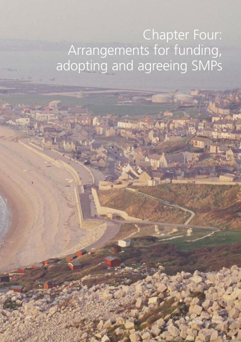
Site of Special Scientific Interest:Chesil & The Fleet, Dorset
33
Studies leading to producing or reviewing SMPs are essentially studies of coastal processes underthe Coast Protection Act 1949 or the Environment Act 1995. For most practical purposes, weclass the coast as being limited to areas defined in schedule IV (see the glossary) of the CoastProtection Act 1949, which defines the upstream limits of the ‘coast’ in rivers and estuaries.However, we also accept that many coastal processes do not recognise these fixed boundariesso we are prepared to be flexible where coastal processes may be influenced by the effects ofestuaries and rivers. Similarly, boundaries for catchment flood management plans (CFMPs) inestuaries will need careful decisions to avoid any repeated studies. (See appendices E and F,volume 2.) If you have applied for grant aid, you must show that the processes you will studyupstream of these boundaries are likely to have a significant effect on considering options for thelength of coast concerned and tie in with CFMPs planned in the area. In many areas, CFMPs willbe in place before SMP reviews begin.
Grant aid may be available towards preparing and updating SMPs. In England, a nominatedcoastal defence authority normally applies on behalf of the coastal group or client steering group(CSG). If the CSG proposes a study, they will need to show how they will take account ofneighbouring shorelines when preparing a plan.
It is important to consider involving stakeholders while preparing your SMP so that you can gainapprovals and adopt your SMP. As a result, you will need to consider reasonable costs as part ofyour application. However, when you have finished the SMP, any public relations exercises youhave carried out and ongoing monitoring of the action plan are not covered by the coastalprocess study, so you will need to consider other sources of funding.
Once SMPs are in place, we will expect any flood and coast protection schemes to be consistentwith them. This means that SMPs will play an important part in approving future schemes, so weadvise you to keep us informed about developing and adopting the plan. We will need to besatisfied that the plan has dealt with all the appropriate issues, including that:
• it fully takes account of natural processes and wider environmental, social and economicissues; and
• all reasonable steps have been taken to deal with conflicting objectives.
Our Flood Management Division will work with other colleagues who are responsible for otherDefra initiatives (such as water quality) before formally responding to the adopted plan. Once theSMP is complete (including consultation) and adopted by the lead coastal authority, regionalflood defence committee, Natural England and the other partner authorities, you should send itto us for our agreement.
This agreement will confirm that we are satisfied that: • the procedures for developing an overall understanding, identifying and analysing problems
and developing policies have been followed in line with current guidance; and
• the SMP meets the principles of sustainable development (see the glossary).
Important note: Our agreement to an SMP does not commit us to any future funding. (Anexample of an agreement letter is in annex B.)
The SMP will include an associated action plan. This should include a prioritised programme offuture strategies, and an outline of future schemes, coastal monitoring and studies. Thisprogramme will be useful as the basis for developing medium-term plans and should be realisticin achieving the policies that the SMP sets out. The action plan should be affordable, setting outthe sources of funding for achieving the plan.
The action plan should form the basis for any future changes in regional and local coastal policiesand how this will be achieved. It should:
• confirm the methods you have used to make sure the plan contributes to regional spatialstrategies and local development plans; and
• make it clear how stakeholders can get involved in this process and contact the variouspartner authorities that have adopted the SMP findings.
If necessary, action plans should go further than individual SMPs to link with recommendationsin neighbouring SMP areas. You should include a process for reviewing the SMP regularly.We expect that individual operating authorities will develop or update strategies covering thosepolicy units within their area of responsibility where significant work or management activitiesare needed before the next plan review. These strategies provide a detailed assessment for policyunits (see our FCDPAG2 guidance) and will involve a more thorough examination of all theoptions, including economic analysis in line with our FCDPAG3 guidance and future updates(www.defra.gov.uk/environ/fcd/pubs/pagn/fcdpag3/default.htm).
34
ReferencesCatchment flood management plans volume 1 – policy guidance (published July 2004)(www.environment-agency.gov.uk/commondata/105385/cfmp_policy_891477.pdf)
Defra 2004, ‘Making Space for Water: Developing a new Government strategy for flood andcoastal erosion risk management in England: A consultation exercise’www.defra.gov.uk/environ/fcd/policy/strategy.htm
Defra 2005, ‘Making Space for Water: Taking forward a new government strategy for flood andcoastal erosion management in England: Government first response’www.defra.gov.uk/environ/fcd/policy/strategy.htm
Defra and Welsh Office 2001, ‘Shoreline management plans: a guide for coastal defenceauthorities’, Defra Publications (Replaced by this document.)
Department of the Environment 1990, ‘Planning Policy Guidance Note (PPG) 14: Development onUnstable Land’, The Stationery Office
Department of the Environment 1992, ‘Planning Policy Guidance Note (PPG) 20: CoastalPlanning’, The Stationery Office
Department of the Environment 1994, ‘Planning Policy Guidance Note (PPG) 9 NatureConservation’, The Stationery Office
Department of the Environment 1996, ‘Planning Policy Guidance Note (PPG) 14 Annex:Landslides and Planning’, The Stationery Office
Department of the Environment, Transport and the Regions 2001, ‘Planning Policy Guidance 25:Development and Flood Risk’ consultation paper
English Nature, Environment Agency, The European Union Financial Instrument for theEnvironment (LIFE) and the Centre for Coastal and Marine Sciences 2000, ‘Coastal HabitatManagement Plans: An interim guide to content and structure’
Foresight Flood and Coastal Defence Project 2004, Future Flooding, Office of Science andTechnology (www.foresight.gov.uk)
Halcrow 2002, ‘Futurecoast’ (www.defra.gov.uk/environ/fcd/Futurecoast.htm)
HR Wallingford 2002, ‘UK Climate Impacts Programme 2002 Climate Change Scenarios:Implementation for Flood and Coastal Defence: Guidance for Users R&D’ Technical ReportW5B-029/TR December 2002
HR Wallingford 1994, ‘Coastal Management: Mapping of Littoral Cells’, report SR 328
MAFF and Welsh Office 1995, ‘Shoreline management plans: a guide for coastal defenceauthorities’, MAFF publications (Replaced by 2001 SMP Guidance Note.)
35
MAFF 1998, ‘Interim Guidance Prepared by Shoreline management plans Advisory Group:Advisory Notes Numbers 1 to 12’, Defra (Replaced by 2001 SMP Guidance Note.)
MAFF 1999, ‘High Level Targets for Flood and Coastal Defence and Elaboration of theEnvironment Agency’s Flood Defence Supervisory Duty’, MAFF Flood and Coastal Defence
MAFF 2000, ‘A Review of shoreline management plans, 1996 to 1999’, Final Report MAFF Floodand Coastal Defence, March 2000
M Hulme, GJ Jenkins, X Lu, JR Turnpenny, TD Mitchell, RG Jones, J Lowe, JM Murphy, D Hassell,P Boorman, R McDonald and S Hill, 2002 ‘Climate Change Scenarios for the United Kingdom:The UKCIP02 Scientific Report‘,Tyndall Centre for Climate Change Research, School ofEnvironmental Sciences, University of East Anglia, Norwich, UK
UK Biodiversity Group 1995, ‘Biodiversity: The UK Steering Group Report – Volume 1: Meetingthe Rio Challenge, The Stationery Office
UK Biodiversity Group 1999, ‘Biodiversity: The UK Biodiversity Group Tranche 2 Action Plans –Volume 5 Maritime Species and Habitats’, English Nature and Natural England
Welsh Office 1998, ‘Technical Advice Note (TAN) 14: Coastal Planning’, The Stationery Office
Welsh Assembly Government 2002, ‘Planning Policy Wales’
Welsh Assembly Government 2004, ‘Technical Advice Note (TAN) 15: Development and Flood Risk’
Other guidance available
The following guides on assessing flood and coastal defence in England and Wales are available.
FCDPAG1 Overview (published March 2001)
FCDPAG2 Strategic planning and appraisal (published March 2001)
FCDPAG3 Economic appraisal (published December 1999) (updates athttp://defraweb/environ/fcd/pubs/pagn/fcdpag3/default.htm)
FCDPAG4 Approaches to risk (published March 2000)
FCDPAG5 Environmental appraisal (published March 2000)
FCDPAG6 Post project evaluation (to be published)
These guides are regularly updated, and these and any updates are available from our website atwww.defra.gov.uk/environ/fcd/pubs/pagn/default.htm.
36
37
GlossaryAccretionIn geography, accretion means the land increasing due to sediment being added to it.
AssetThis refers to something of value and may be environmental, economical, social, recreational andso on.
Beach rechargeThis is the management practice of adding to the natural amount of sediment (such as sand) ona beach by using material from elsewhere. This is also known as beach replenishment,nourishment or feeding.
Beach recharge materialNatural sediment sourced from elsewhere used to replenish the beach.
Behavioural systems approachThis is a method of looking at how a coast is changing and is likely to change in the future byassessing all the factors that affect its behaviour at a range of scales, both in terms of time anddistance. This approach was adopted for the Futurecoast project (see the definition below).www.defra.gov.uk/environ/fcd/Futurecoast.htm
BiodiversityThe richness and variety of wildlife (both plant and animal) and habitats on earth.
Biodiversity action plansNational action plans for an important habitat or species, approved by the Government, as partof the overall UK biodiversity action plan. (See the reference for the UK Biodiversity Group, 1995and 1999.) Each action plan provides a description of the species or habitat and any threats to it.It sets targets for recovery and lists the actions needed to meet these targets.
Biodiversity objectiveAn aim for maintaining and improving biodiversity within a habitat.
Biodiversity targetThis target was approved by the World Summit on Sustainable Development.
“To achieve, by 2010, a significant reduction of the current rate of biodiversity loss at the global,regional and national level as a contribution to easing poverty and to benefit all life on earth.”
Catchment flood management planA large-scale planning framework for managing flood risk to people and the developed andnatural environment. See guidance published in July 2004 (www.environment-agency.gov.uk/commondata/105385/cfmp_policy_891477.pdf) and our website (www.defra.gov.uk/environ/fcd/policy/strategy.htm) for further details.
Client steering group (CSG)A group formed to review a shoreline management plan.
38
Coastal defenceA term used to cover both coastal protection against erosion and sea defence against flooding.
Coastal defence strategy planA detailed assessment of the coastal defence options for a policy unit, based on our guidance:FCDPAG2.
Coastal habitat management plan (CHaMP)A management plan that identifies the flood and coastal defence work that is likely to beneeded in a given area to conserve a European site (or group of sites), particularly where thecurrent defence line may not be able to be maintained over the long term. A guidance note wasproduced in 2000 by English Nature and others (see the references list for details).
Coastal process unitsThese were defined by previous SMPs as a length of shoreline in which the physical processes arerelatively independent from the processes in neighbouring coastal process units.
Coastal processesThe set of processes that operate along a coastline.
Coastal squeezeThe process by which coastal habitats and natural features are progressively lost or drowned,caught between coastal defences and rising sea levels.
Coastal zone management planPlans through which local authorities and others put planning objectives and policies intopractice for an area of the coast, which deal with a range of issues such as managing,developing, recreating and conserving landscapes.
ConsequenceAn outcome or a result, such as an economic, social or environmental effect. It may be expressedas a quantity (such as monetary value), a category (high, medium or low) or a description (seeour guidance: FCDPAG4).
Earth heritageA term which describes landscapes identified as important for their fossils, minerals or othergeological interest.
Economic assessmentAn assessment which takes account of a wide range of costs and benefits, generally those thatcan be valued in money terms.
EnvironmentThis term covers landscape and natural beauty, wildlife, habitats, and buildings, sites and objectsof archaeological, architectural or historical interest.
EpochThis refers to a period of time. In the SMPs three epochs are defined – 0 to 20, 20 to 50 and 50to 100 years from the present.
ErosionThe loss of land due to the effects of waves and, in the case of coastal cliffs, slope processes(such as high groundwater levels). This may include cliff instability, where coastal processes resultin landslides or rock falls.
European siteAny site that has been officially named (‘designated’) as a site of international natureconservation importance, either as a special protection area (SPA), a special area of conservation(SAC) or a Ramsar (see the glossary) site. When considering planning, it is government policy totreat possible SPAs, candidate SACs and listed Ramsar sites as if they were already designated.
FuturecoastA study we asked for to provide consistent information on coastal processes and possible futuredevelopment of the coast, for the whole of England and Wales(www.defra.gov.uk/environ/fcd/Futurecoast.htm).
GeomorphologyThe study of landforms on the earth’s surface and processes of forming land.
Habitat DirectiveEC Directive 92/43 on conserving natural habitats, wildlife and plant life.
Habitat RegulationsThe Conservation (Natural Habitats & c.) Regulations 1994. This makes the Habitats Directive UK law.
HazardA situation with the potential to result in harm. A hazard does not necessarily lead to harm.
Heritage CoastHeritage Coast is a national definition to cover the most unspoilt areas of undeveloped coastlinearound England and Wales.
High-level targets (HLTs)HLTs have been developed with colleagues in the Environment Agency, Association of DrainageAuthorities and the Local Government Association as well as with the wider Flood ManagementStakeholder Forum (see www.defra.gov.uk/environ/fcd/policy/forum.htm for details of itsmembership). They are not legal requirements but are important for delivering government policyso we expect all operating authorities to put them into practice. Further details on the targets areon our website at www.defra.gov.uk/environ/fcd/hltarget/default.htm.
Historic environmentPrevious environmental conditions over a range of timescales.
Integrated coastal zone management (ICZM)A strategy to identify lasting levels of economic and social activity in our coastal areas whileprotecting the coastal environment. It brings together all those involved in developing, managing andusing the coast within a framework that makes it easier to join their interests and responsibilitiestogether. Also see our website at http://defraweb/environment/water/marine/uk/iczm/index.htm.
39
40
Intertidal areasThe area between mean high water level and mean low water level in a coastal region.
InundationAn overflow of water or an expanse of water submerging land.
Landscape character assessmentA way of identifying and explaining different things (such as woodlands, hedgerows, moors,mountains and farmland, building styles and historic artefacts) which give a place its uniquecharacter.
Management unitsThese were defined by previous SMPs as a length of shoreline with similar characteristics in termsof coastal processes and assets at risk that can be managed effectively. They have now beenreplaced by policy units.
Natural areasThis covers both the small number of natural areas and the much greater semi-natural areas ofBritain, which have been influenced by people’s actions over the years.
Nature conservation – designationsBelow is a list of statutory and non-statutory (see the glossary) nature conservation designations(areas identified as special sites for their wildlife and habitats).
Sites of special scientific interest (SSSIs) designated for their wildlife and earth heritage (see thedefinition above) interest under the Wildlife and Countryside Act 1981.
National nature reserves designated under the Wildlife and Countryside Act 1981.
Areas of special protection, formerly bird sanctuaries, designated under the Wildlife andCountryside Act 1981.
Wetlands of international importance (Ramsar sites) designated under the 1971 RamsarConvention.
Special areas of conservation (SACs) designated under the EC Habitats Directive (92/43/EECConservation of Natural Habitats and of Wild Fauna and Flora).
Special protection areas (SPAs) designated under the EC Birds Directive (79/409/EEC Conservationof Wild Birds).
Local nature reserves (LNRs) designated by local authorities under section 21 of the NationalParks and Access to the Countryside Act 1949.
Non-statutory nature conservation sites, such as regionally important geological orgeomorphological sites (RIGSs) or sites of interest for nature conservation (SINCs) and land heldfor conservation purposes by other organisations (such as The National Trust).
Natural ProcessesThose processes over which people have no significant control (such as wind and waves).
41
Net ‘along shore’ movementThe difference in the yearly total movement of sand and shingle in each direction along the shore.
Non-statutory conservationLocal-authority conservation plans aimed to protect a local environmental resource.
Operating authorityAn organisation with legal powers to carry out flood defence or coast protection activities,usually the Environment Agency or maritime district council.
Planning policy guidance (PPG)Issued by the Government to set out its national land use policies for England on different areasof planning. These are gradually being replaced by planning policy statements (PPS).
Policy unitA length of shoreline with similar characteristics in terms of coastal processes and assets at riskthat can be managed efficiently.
Preferred policyThe policy that best meets the objectives set out in Box E.
Public service agreementThe public service agreement (PSA) framework is a Government objective to drive forward thehighest priorities and ambitions for delivery within the context of public services.
RamsarThe conservation on wetlands, signed in Ramsar, Iran, in 1971 is a treaty between governmentswhich provides the framework for national action and international co-operation for protectingwetlands and their resources.
Residual lifeThe time until when a defence is no longer able to achieve minimum ‘acceptable performance’.
Residual riskThe risk which remains after managing and reducing risks. It may include, for example, risk dueto very severe storms or risks from unexpected hazards.
Risk assessmentConsidering risks to people and the developed, historic and natural environment.
Risk managementManaging and monitoring risks(www.environment-agency.gov.uk/commondata/103599/4iarbmpes_777869.doc).
River basin management plansThe plans which must be developed to put the EU Water Framework Directive into force.
Schedule IVPart of the Coast Protection Act 1949 which says waters excluded for purposes of definitions of‘sea’ and ‘seashore’, that is the upstream limit in estuaries and rivers.
42
Scheduled monumentsThe main legislation concerning archaeology in the UK is the Ancient Monuments andArchaeological Areas Act 1979. This Act, building on legislation dating back to 1882, providesfor nationally important archaeological sites to be protected as scheduled ancient monuments.
Sediment cellA length of coastline and its associated nearshore area within which the movement of coarsesediment (sand and shingle) is largely self-contained. Interruptions to the movement of sandand shingle within one cell should not affect beaches in a neighbouring sediment cell. A reportwas produced in 1994 defining sediment cells around the coast of England and Wales(author: HR Wallingford 1994).
Sediment sub-cellA smaller part of a sediment cell within which the movement of coarse sediment (sand andshingle) is relatively self-contained.
Sediment supplyAdding sediment to a beach.
Shoreline management policyA general term for any management option.
Shoreline responseThe way the boundary between the land and the sea changes due to varying coastal process andpeople’s actions.
Significant effectAn important effect – for example, if a plan or project is likely to affect a European site, you needto decide whether or not it would have a ‘significant effect’. If there is any doubt, you must consultNatural England or Countryside Council for Wales. They will advise whether, in their view, theproposed scheme would be likely to have a significant effect on the habitat interests of the site.
Spatial planningSpatial planning refers to the methods used to balance demands for development with the needto protect the environment, and to achieve social and economic objectives.
StakeholderA person or organisation with an interest or concern in something. A list of possible stakeholdersfor the SMP is included on page 44.
Statutory conservationA legal duty to protect and manage an area of national importance in terms of environmental value.
StrategicThis describes carrying out any process in a wide-ranging way, taking account of all associatedeffects, interests of other people and the widest possible options for solving a problem. In thisdocument, the word ‘strategic’ does not mean any particular level in the planning process.
Strategic environmental assessment (SEA)A process of assessing the environmental opportunities and restrictions of a project, andidentifying and managing its implications. An SEA is a legal requirement of certain plans andprogrammes, under the Environmental Assessment of Plans and Programmes Regulations 2004.
Sustainable development principlesStandards set by the UK Government, the Scottish Executive and the Welsh AssemblyGovernment for a policy to be sustainable. See our website atwww/defra.gov.uk/environment/sustainable/index.htm.
Sustainable managementThe process of developing (land, cities, business, communities and so on) that meets the needsof the present without compromising the ability of future generations to meet their own needs.
Sustainable policiesSustainable policies lead to coastal defence solutions that avoid committing future generations toinflexible and expensive options for defence. They will usually include considering relationshipswith other defences and likely developments and processes within a coastal cell or sub-cell.
Technical advice notes (TANs)Current land use planning policy in Wales is contained in Planning Policy Wales (Welsh AssemblyGovernment, 2002) which provides the strategic policy framework for the effective preparationof local planning authorities’ development plans. These are supported by 20 topic-basedtechnical advice notes (TANs).
Transparent and auditableThis means the process is open so that people can see what the process involves and understandwhy a decision has been made.
Water Framework DirectiveThis Directive is European Union legislation which covers all inland and coastal waters. TheDirective sets a framework which should provide substantial benefits for managing water overthe long term. Further details are on our website at www.defra.gov.uk/environment/water/wfd.
43
44
Stakeholders and people you can consultThe level of consultation you carry out will depend on the range of interested people you identifyand their level of involvement in the area. Those who are most likely to have an interest in thedifferent aspects of the area are listed below. This list is not full, and you should consult localinterest groups where they exist. We recommend that you involve all interested people andgroups at all stages when developing an SMP. We give more detail in volume 2, appendix A.
PlanningPlanning authorities, organisations involved in development plans or coastal zone managementplans (such as regional government)
Flood managementDefra Flood Management Division, Welsh Assembly Government (WAG), the EnvironmentAgency, local authorities and internal drainage boards (IDBs) where appropriate
Marine environmentDefra Marine Environment Division, Welsh Assembly Government (WAG), Natural England andCountryside Council for Wales (CCW)
Ports, harbours and navigationPort and harbour authorities and the Office of the Deputy Prime Minister (ODPM)
AgricultureNatural England, National Farmers’ Union (NFU), Farmers’ Union of Wales (FUW), Tenant Farmers’Association and Country Land and Business Association (CLA)
LandownersCountry Land and Business Association (CLA). Where appropriate, Crown Estate Commissioners,the National Trust, the Royal Society for the Protection of Birds (RSPB), county wildlife trusts, theForestry Commission, local councils and the Ministry of Defence
FisheriesSea fisheries committees (where fisheries interests may be affected and where sand and gravel isremoved from offshore)
BusinessConfederation of British Industry, chambers of commerce and the Association of British Insurers
Nature conservationNatural England, Countryside Council for Wales (CCW), Worldwide Fund for Nature (WWF),county wildlife trusts, Marine Conservation Society, the Royal Society for the Protection of Birds(RSPB), Joint Nature Conservation Committee, local nature conservation organisations, regionallyimportant geological or geomorphological site (RIGS) groups and the Forestry Commission
LandscapeNatural England, Countryside Council for Wales (CCW), Heritage Coast Forum, Council for theProtection of Rural England (CPRE), Campaign for the Protection of Rural Wales (CPRW) and theForestry Commission

Archaeological and historical sites or featuresEnglish Heritage, Cadw, and county, district and local authorities’ archaeological andconservation officers
Recreation and accessNatural England, Countryside Council for Wales (CCW), water companies, the ForestryCommission, town and parish councils, British Association for Shooting and Conservation (BASC),Ramblers’ Association, Royal Yachting Association and other sporting associations
Local interestsThe general public and local groups
45
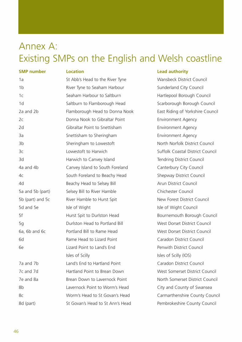
Annex A:Existing SMPs on the English and Welsh coastlineSMP number Location Lead authority
1a St Abb’s Head to the River Tyne Wansbeck District Council
1b River Tyne to Seaham Harbour Sunderland City Council
1c Seaham Harbour to Saltburn Hartlepool Borough Council
1d Saltburn to Flamborough Head Scarborough Borough Council
2a and 2b Flamborough Head to Donna Nook East Riding of Yorkshire Council
2c Donna Nook to Gibraltar Point Environment Agency
2d Gibraltar Point to Snettisham Environment Agency
3a Snettisham to Sheringham Environment Agency
3b Sheringham to Lowestoft North Norfolk District Council
3c Lowestoft to Harwich Suffolk Coastal District Council
3d Harwich to Canvey Island Tendring District Council
4a and 4b Canvey Island to South Foreland Canterbury City Council
4c South Foreland to Beachy Head Shepway District Council
4d Beachy Head to Selsey Bill Arun District Council
5a and 5b (part) Selsey Bill to River Hamble Chichester Council
5b (part) and 5c River Hamble to Hurst Spit New Forest District Council
5d and 5e Isle of Wight Isle of Wight Council
5f Hurst Spit to Durlston Head Bournemouth Borough Council
5g Durlston Head to Portland Bill West Dorset District Council
6a, 6b and 6c Portland Bill to Rame Head West Dorset District Council
6d Rame Head to Lizard Point Caradon District Council
6e Lizard Point to Land’s End Penwith District Council
Isles of Scilly Isles of Scilly (IOS)
7a and 7b Land’s End to Hartland Point Caradon District Council
7c and 7d Hartland Point to Brean Down West Somerset District Council
7e and 8a Brean Down to Lavernock Point North Somerset District Council
8b Lavernock Point to Worm’s Head City and County of Swansea
8c Worm’s Head to St Govan’s Head Carmarthenshire County Council
8d (part) St Govan’s Head to St Ann’s Head Pembrokeshire County Council
46
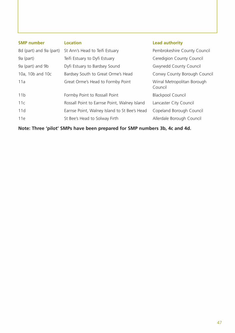
SMP number Location Lead authority
8d (part) and 9a (part) St Ann’s Head to Teifi Estuary Pembrokeshire County Council
9a (part) Teifi Estuary to Dyfi Estuary Ceredigion County Council
9a (part) and 9b Dyfi Estuary to Bardsey Sound Gwynedd County Council
10a, 10b and 10c Bardsey South to Great Orme’s Head Conwy County Borough Council
11a Great Orme’s Head to Formby Point Wirral Metropolitan Borough Council
11b Formby Point to Rossall Point Blackpool Council
11c Rossall Point to Earnse Point, Walney Island Lancaster City Council
11d Earnse Point, Walney Island to St Bee’s Head Copeland Borough Council
11e St Bee’s Head to Solway Firth Allerdale Borough Council
Note: Three ‘pilot’ SMPs have been prepared for SMP numbers 3b, 4c and 4d.
47
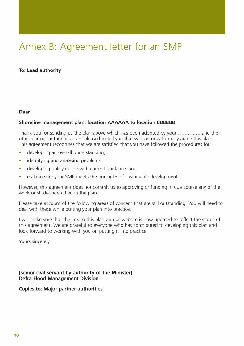
Annex B: Agreement letter for an SMP
To: Lead authority
Dear
Shoreline management plan: location AAAAAA to location BBBBBB
Thank you for sending us the plan above which has been adopted by your ………….. and theother partner authorities. I am pleased to tell you that we can now formally agree this plan.This agreement recognises that we are satisfied that you have followed the procedures for:
• developing an overall understanding;
• identifying and analysing problems;
• developing policy in line with current guidance; and
• making sure your SMP meets the principles of sustainable development.
However, this agreement does not commit us to approving or funding in due course any of thework or studies identified in the plan.
Please take account of the following areas of concern that are still outstanding. You will need todeal with these while putting your plan into practice.
I will make sure that the link to this plan on our website is now updated to reflect the status ofthis agreement. We are grateful to everyone who has contributed to developing this plan andlook forward to working with you on putting it into practice.
Yours sincerely
[senior civil servant by authority of the Minister]Defra Flood Management Division
Copies to: Major partner authorities
48

PB 11726
Nobel House17 Smith SquareLondon SW1P 3JR
www.defra.gov.uk