Embed Size (px)
Citation preview

SHORELINE MANAGEMENT PLAN REVIEW (SMP2)
POOLE & CHRISTCHURCH BAYS HURST SPIT TO DURLSTON HEAD
Scoping Report
23rd July 2008

Poole & Christchurch Bays SMP2 Scoping Report
Poole & Christchurch Bays Shoreline Management Plan Scoping Report
CONTENTS 1 Introduction............................................................................................................4
1.1 Coastal cells and Shoreline Management Plans..........................................4 1.2 Poole & Christchurch Bay SMP2 (Hurst Spit to Durlston Head) ................5
2 Objectives ..............................................................................................................6 2.1 Purpose of scoping report.............................................................................6 2.2 Summary of objectives ..................................................................................6
3 Client Steering Group............................................................................................7 3.1 Introduction ....................................................................................................7 3.2 Member organisations ...................................................................................7 3.4 Organisational structure ................................................................................8 3.5 Roles and responsibilities .............................................................................9
4 Definition of SMP boundaries and description of coastline ............................11 4.1 General ..........................................................................................................11 4.2 Description of coastline...............................................................................11 4.3 Estuaries and lagoons .................................................................................18
5 Proposed scope of the SMP ...............................................................................20 5.1 DEFRA guidance for SMPs ..........................................................................20 5.2 Phases in the development of the SMP ......................................................20 5.3 Interpretation of the Defra guidance ...........................................................20 5.4 Integration with existing management plans .............................................20 5.5 Special issues for study area ......................................................................23 5.6 Programme and progress on SMP2 to date ...............................................24
6 Stakeholder engagement ....................................................................................25 6.1 Strategy .........................................................................................................25 6.2 Database of stakeholders ............................................................................26
7 Information for producing the SMP....................................................................27 7.1 Sources of information ................................................................................27 7.2 Data management.........................................................................................28
8 Additional Investigations ....................................................................................29 8.1 DEFRA guidance ..........................................................................................29 8.2 Desk top appraisal........................................................................................29
9 Environmental Assessments..............................................................................30 9.1 Strategic Environmental Assessment (SEA) .............................................30 9.2 Appropriate Assessment (AA).....................................................................30
References ..................................................................................................................31
- 2 -

Poole & Christchurch Bays SMP2 Scoping Report
Appendices .................................................................................................................32
Appendix A: Abbreviations and acronyms ..........................................................33 Appendix B: Overview of tasks from Defra SMP Guidelines..............................35 Appendix C: SMP workflow plan from Defra SMP Guidelines ...........................38 Appendix D: SMP2 information leaflet .................................................................39 Appendix E: Questionnaire and letters sent to potential stakeholders.............40 Appendix F: Summary of investigations recommended by SMP1 ....................52 Appendix G: Natural England designated sites ..................................................56 Appendix H: Details of principal contacts ...........................................................59 Appendix I: List of Stakeholders invited to participate in SMP review..............61 Appendix J: Database of data held by stakeholders ..........................................83 Appendix K: List of stakeholders expressing an interest in joining the Key Stakeholder Group (for questionnaires returned to 10th July 2008) ...................90 Appendix L: Notes on Appropriate Assessment - the need and process .........92 Appendix M: Map of SMP area ..............................................................................95
- 3 -

Poole & Christchurch Bays SMP2 Scoping Report
1 Introduction
1.1 Coastal cells and Shoreline Management Plans
1.1.1 It is now widely accepted that management of the shoreline needs to be done on a strategic basis, the preferred unit being the natural coastal sediment cell. Research commissioned by the Ministry of Agriculture, Fisheries & Food (MAFF), now Department for Environment Food and Rural Affairs (Defra) in the 1990’s identified 11 major, or macro, sediment cells around the coast of England and Wales (Hydraulics Research Ltd, 1993).
1.1.2 These macro sediment cells were further divided into sub-cells, each regarded as
functioning more or less independently in terms of sediment transport. Sub-cells are generally accepted as the most appropriate and more manageable units for the consideration of natural processes.
1.1.3 A Shoreline Management Plan (SMP) is a non-statutory document that offers
guidance at a strategic level, designed to assist coastal defence decision making over a 100 year time period. It aims to identify sustainable coastal defence strategic options, taking account of the influence and needs of both the natural environment and the human built environment.
1.1.4 A SMP should set out the policies and broad objectives for the future management
of a defined coastal unit, developed in consultation with all interested parties. Its formulation involves the collection and assessment of information on coastal processes and other human and environmental aspects of the coastal zone. A SMP should also provide an agreed framework within which individual member authorities can address coastal defence priorities and provide details of schemes for their own particular stretch of shoreline.
1.1.5 Defra has policy responsibilities for flood and coastal defence in England. However,
delivery is the responsibility of a number of flood and coastal defence “operating authorities” (i.e. the Environment Agency, local authorities and internal drainage boards). Responsibilities differ according to the type of authority and its statutory powers (e.g. only local authorities have the powers to carry out coast protection schemes and studies).
1.1.6 The delivery of SMPs is achieved through operating authorities in coastal cells
working collaboratively in regional coastal groups, but with designated “Lead Authorities” taking a project management role and making any necessary applications (for grant etc).
- 4 -

Poole & Christchurch Bays SMP2 Scoping Report
1.2 Poole & Christchurch Bay SMP2 (Hurst Spit to Durlston Head)
1.2.1 The first round of SMP for this area was carried out in the 1990s in accordance with MAFF (now Defra) Flood Management Division’s high-level policy.
1.2.2 At the time of the original SMP studies, Defra guidance suggested that SMPs be
reviewed and, if necessary, updated approximately every 5 years. It is now 8 years since the completion of the 1st Poole & Christchurch Bay SMP.
1.2.3 In March 2005, Defra issued new High Level Targets for Flood and Coastal Erosion
Risk Management. Target 3 requires designated Lead Authorities to produce second generation SMPs in accordance with revised Defra guidance. HLT3 requires the revised plans to be complete by March 2010.
1.2.4 First generation SMPs were developed on the information available at the time.
During the preparation of many first round SMPs nationally, it became apparent that the quality and extent of information available was deficient in certain aspects, particularly informing how the coast would evolve.
1.2.5 Since the completion of the original SMP, there is now significant new information
resulting from strategic studies, coastal monitoring, coastal defence schemes, changes in environmental designations etc. Furthermore, there have been significant nationally focused studies such as Future Coast and new indicative coastal flood mapping that need to be taken into consideration. Defra has also produced updated guidance on how to produce Shoreline Management Plans, the latest of which was published in March 2006.
1.2.6 It is, therefore, appropriate that the SMP is reviewed and (if necessary) revised at
this time to take account of these intervening studies, to consider the long-term sustainability of the shoreline and to determine clear policies based on both the original data used in developing the first generation SMP and the updated data and scientific knowledge. This will then ensure that the SMP for Poole & Christchurch Bay is consistent with other second-generation SMPs which are being prepared around the English coastline.
- 5 -

Poole & Christchurch Bays SMP2 Scoping Report
2 Objectives
2.1 Purpose of scoping report
2.1.1 This scoping report has been prepared for the principal purpose of providing information for the SMP2 consultant to assist in the preparation of the Shoreline Management Plan review. The report may also be useful, however, in providing background information to members of those organisations involved in preparing and implementing SMP2.
2.1.2 The report represents a summary of scoping work, data collection and preliminary
stakeholder engagement, carried out by the Client Steering Group in the period November 2007 to July 2007.
2.2 Summary of objectives
2.2.1 The objectives of this scoping report are as follows:
a) to explain the organisational structure of the Client Steering Group, its roles and responsibilities;
b) to define the boundaries of the SMP;
c) to summarise progress achieved on SMP2 to date;
d) to define the proposed scope of the SMP review in relation to Defra guidance;
e) to identify special issues which will need to be considered in the second round of SMP;
f) to list existing coastal management plans which will need to be integrated into SMP2;
g) to define the stakeholder engagement strategy;
h) to provide databases of information for carrying out SMP2, including lists of registered stakeholders and the sources of information;
i) to define how data should be managed during the SMP2 process;
j) to define how additional investigations and appropriate assessment should be dealt with in the SMP2 process;
k) to define the proposed programme for preparing and implementing SMP2.
- 6 -

Poole & Christchurch Bays SMP2 Scoping Report
3 Client Steering Group
3.1 Introduction
3.1.1 The coastline covered by the Poole & Christchurch Bay SMP comes within the boundaries of five local authorities. They and the Environment Agency have certain permissive powers for defending the coast from flooding and coastal erosion. Together they are required to review SMP1 (Published 1999) and produce a new and updated SMP2 for sustainable coastal defence management. This is achieved through the auspices of the Poole & Christchurch Bay Client Steering Group, comprising the five local authorities, the Environment Agency, and other key bodies. Other members of the group are; Natural England, National Trust and Poole Harbour Commissioners.
3.1.2 The Client Steering Group (CSG) was formed in June 2007, with Bournemouth
Borough Council being elected the lead authority.
3.2 Member organisations
3.2.1 The CSG is made up of the members listed in Table 1.
Table 1. CSG member organisations
Voting Members
Flood & Coast Protection Operating Authorities Purbeck District Council
Borough of Poole
Bournemouth Borough Council
Christchurch Borough Council
New Forest District Council
Environment Agency
Non-Voting Members
Associate Partners Dorset County Council
Hampshire County Council
National Trust
Natural England
Poole Harbour Commissioners
- 7 -

Poole & Christchurch Bays SMP2 Scoping Report
3.4 Organisational structure
3.4.1 The key tasks in carrying out assessments to support policy development of the SMP will be carried out by a SMP Consultant appointed by Bournemouth Borough Council and managed by the Client Steering Group.
3.4.2 At various consultation stages, an Elected Members Group (EMG) and a Key
Stakeholders Group (KSG) will be engaged in the Review via the Client Steering Group. Additionally, other stakeholders may be invited to provide input direct to the SMP2 consultant.
3.4.3 The relationships between the various groups are shown in Figure 1, and the details
of principal contacts are given in Appendix H.
Figure 1. The organisational structure of the SMP groups.
Client Steering Group
SMP Consultant
Elected Members Group
Key Stakeholders Group
Other Stakeholders
- 8 -

Poole & Christchurch Bays SMP2 Scoping Report
3.5 Roles and responsibilities
3.5.1 Further information on the roles and responsibilities of the SMP groups, and details of current membership, is given in Table 2.
Table 2. The roles and responsibilities of the SMP Groups and associated organisations.
Group Membership Roles and Responsibilities
Client Steering Group (CSG)
• Chairman – Officer of Bournemouth BC (lead authority) – David Harlow
• Provides the client expertise in determining the scope and extent of the SMP review and day-to-day project management
• Officer of Bournemouth BC – Geoff Tyler
• Provides administrative support
• Local Authority Rep – Andrew Bradbury (New Forest DC)
• Provides expert advice to the CSG in determining the scope and extent of the SMP
• Local Authority Rep – Steve Cook (New Forest DC)
• Scoping report, procurement and works in partnership with the consultant and CSG to develop the SMP
• Local Authority Rep – Pete Ferguson (New Forest DC)
• Scoping report, procurement and works in partnership with the consultant and CSG to develop the SMP
• Local Authority Rep – Steve Woolard (Christchurch BC)
• Works in partnership with the consultant and CSG to develop the SMP
• Local Authority Rep – David Robson (Borough of Poole)
• Works in partnership with the consultant and CSG to develop the SMP
• Local Authority Rep – Mike Goater (Purbeck DC)
• Works in partnership with the consultant and CSG to develop the SMP
• Local Authority Rep – Sarah Austin (Borough of Poole)
• Website development and maintenance
• Environment Agency Rep – Andrew Gill (SW Region)
• Works in partnership with the consultant and CSG to develop the SMP
• Natural England Rep – Richard Caldow (Dorset)
• Works in partnership with the consultant and CSG to develop the SMP
CSG Associate Partners
• Poole Harbour Commissioners Rep – Andrew Ramsbottom
• Works in partnership with the consultant and CSG to develop the SMP
• National Trust Rep – Tony Flux • Works in partnership with the consultant and CSG to develop the SMP
- 9 -

Poole & Christchurch Bays SMP2 Scoping Report
SMP Consultant
• To be procured through formal tendering process
• As defined in the tender document brief
Key Stakeholders Group
• Membership of group yet to be defined. But may include members from the following interest groups;-
• Museums • Industry / commerce • Ramblers • Water Sports • Clubs / societies • Fishing • Land owners • Tourism • Farming / agriculture • Conservation/environment • Parish & Town Councils • Residents Associations • Public Interest Group
• Suggest issues and their priorities to be considered within the SMP
• Meet periodically throughout the SMP review
• Provide comments on proposals being made by the CSG and SMP consultant
• Consider proposals on the overall scope and objectives of the SMP
• Review policies to be carried out in the draft SMP
• Support the public consultation exercise
Elected Members Group
• Elected member representatives from client local authorities and the EA’s flood defence committee
• Consider the issues to be dealt with by the SMP
• Agree the objectives of the SMP • Review the policies to be contained
within the SMP • Agree the priority of issues • Seek ratification of the SMP and its
policies
Other Stakeholders
• Individuals and organisations who are likely to be affected by the decisions of the SMP, but who may not be represented on the KSG
• Provide information on their areas of interest
• Identify issues of concern to them about the management of the coastline
• Respond on the effect of policy proposals on their area of interest
- 10 -

Poole & Christchurch Bays SMP2 Scoping Report
4 Definition of SMP boundaries and description of coastline
4.1 General
4.1.1 The western boundary is defined by Durlston Head (Ordnance Survey Grid reference 403672 077258) and the most easterly boundary is defined by Hurst Spit (Ordnance Survey Grid reference 431863 089722).
4.1.2 Including estuaries, the total length of coast within the SMP is 190km (118 miles). A
map of the SMP area, with its sediment sub-cells, is given in Appendix M. 4.1.3 The Poole & Christchurch Bays SMP includes Swanage, Studland and Durlston
Bays along with Poole and Christchurch Harbours. The SMP crosses the county boundary between Hampshire and Dorset.
4.2 Description of coastline 4.2.1 Durlston Head to Peveril Point (DUR 1 to 3)
This frontage includes Durlston Bay, which is primarily undefended. There is a very short length of defended cliff protecting Durlston cliff flats, where controversial cliff stabilization measures have been implemented. The frontage is highly designated:
• Dorset & East Devon World Heritage Site • Isle of Portland to Studland Cliffs SAC • St Albans Head to Durlston Head SAC • South Dorset Coast SSSI • West Dorset Heritage Coast • Dorset AONB
Fresh geological exposures are maintained through active cliff erosion, providing natural sediment inputs to Durlston Bay.
4.2.2 Peveril Point to Handfast Point (SWA 1 to 5)
The southern half of this frontage includes Swanage Bay and the town of Swanage. This is a popular recreational area for beach users, diving, fishing and sailing. Defences in Swanage Bay have recently been improved with 90,000m³ of sand to renourish the beach and groyne reconstruction works. The extreme southern part of this frontage includes Swanage Pier, a sewage treatment works and coastguard station. Moving north beyond the groynes, the coast is undeveloped and undefended. From Ballard Point through to Handfast Point the coastline is characterized by actively eroding chalk vegetated sea cliffs. This area is best known for the stacks, caves and chalk arches with “Old Harry Rocks” at the northern end of the frontage. The whole of this coastline is highly designated with national and international statutory designations.
- 11 -

Poole & Christchurch Bays SMP2 Scoping Report
• Dorset & East Devon World Heritage Site • Isle of Portland to Studland Cliffs SAC • Studland Cliffs SSSI • Purbeck Ridge SSSI • West Dorset Heritage Coast • Dorset AONB
4.2.3 Handfast Point to South Haven Point (STU 1 to 4)
This coastal frontage is predominantly undeveloped although there are some defences protecting beach huts, beach cafes and water sports facilities.
The transition between the harder geology in the southern part of the bay marks the eastern limit of the Jurassic Coast World Heritage site. The coastal frontage is covered by a number of significant environmental designations, including:
• Dorset & East Devon World Heritage Site • Dorset Heathlands Ramsar • Isle of Portland to Studland Cliffs SAC • Dorset Heaths Purbeck & Wareham & Studland Dunes SAC • Dorset Heathlands SPA • Studland Cliffs SSSI • Purbeck Ridge SSSI • Dorset AONB • West Dorset Heritage Coast
Studland Peninsula is characterized by dune ridges that form a key site for coastal geomorphology studies. South Haven Point is the location for the ferry service to Sandbanks.
4.2.4 South Haven Point to North Haven Point (Poole Harbour: PHB 1 to 17)
Managed by Poole Harbour Commissioners, Poole Harbour is a large natural estuary, 38km² in area. It is comprised of a number of separate channels, bays and inlets, which combine to produce a 100 km long section of enclosed coastline, extending from South Haven Point to North Haven Point. The entrance to the Harbour is from the east between the shores of Shell beach (to the south), and Sandbanks (to the north). Situated directly northwest of the entrance is Brownsea Island (owned by the National Trust and the John Lewis Partnership). South of Brownsea Island is Brand’s Bay with Newton Bay & Ower Bay further to the west. These areas are principally mud flats at low tide. Green Island and Furzey Island are located to the south west of Brownsea Island (north of Newton Bay), and between Brownsea and the Upper Wych Channel are Round Island & Long Island. To the west of the Upper Wych Channel is the Arne Peninsula and the Wareham Channel which leads to the town of Wareham. Lytchett Bay in the north of the harbour opens into the Wareham Channel. The small River Sherford drains directly into Lytchett Bay. This area represents the western extremity of the well developed
- 12 -

Poole & Christchurch Bays SMP2 Scoping Report
northern shores of the Harbour, comprising the residential settlement of Poole. Following the northern edge of the Harbour and moving clockwise from Lytchett Bay are the settlements of Upton (north of Lytchett Bay) followed by Hamworthy (including the Port of Poole and Holes Bay), Poole Old Town & Parkstone. Lilliput is situated towards the low-lying Sandbanks area.
Four rivers (the Frome, the Piddle, the Corfe and the Sherford) drain into Poole Harbour from the west; the largest of these are the River Frome and River Piddle at Wareham. The tidal limit of the River Frome lies just upstream of Wareham, whereas the tidal limit of the River Piddle lies just downstream of the Town.
The Port of Poole is located 4 miles north-west from the entrance of the Harbour at the entrance to Holes Bay. The commercial Port is an important local and regional asset, which makes a significant contribution to the economy of the area. In addition there is a significant area of light industry (Hamworthy & eastern side of Holes Bay). There are a number of yacht marinas, slipways and chandlers in the area that service the extensive yachting and boating industries. The largest private sector employers in the County (Sunseeker) construct luxury motor craft at their factory on the side of Back Water Channel. There are approximately 100 registered fishing boats based at the Port and sections of the seabed are used for the cultivation of shellfish.
The entrance to Poole Harbour is only 300m wide and strong tidal currents are experienced, especially on the ebb tide. A chain-link ferry operates across the entrance. In order to maintain the economic viability of the Port it was recently necessary to deepen the Harbour approach channels from 6m to 7.5m below chart datum and to widen the middle ship channel to 100m. Approximately 1.1 million cubic metres (1.65 million metric tonnes) of sand were dredged and used to replenish beaches at Poole, Bournemouth & Swanage. Coastal structures in the Harbour are generally restricted to the developed northern side of the Harbour. The defences are predominantly in the form of seawalls, with revetments and breakwaters existing at a few locations and with mudflats generally characterising the foreshore. Sections of the western flanks of the Harbour & riverbanks are protected by embankments. The landscape of the Harbour is characterised by extensive areas of mudflat, saltmarsh, reedbed, sandunes, heathland, low soft (sandy) cliffs and islands. Many of these areas are afforded protection status by National, European & International designations including:
• Dorset & East Devon World Heritage Site • Dorset Heathlands Ramsar • Poole Harbour Ramsar • Dorset Heaths Purbeck & Wareham & Studland Dunes SAC • Dorset Heaths SAC • Poole Harbour SPA • Dorset Heathlands SPA • Poole Harbour SSSI
- 13 -

Poole & Christchurch Bays SMP2 Scoping Report
• Arne SSSI • The Moors SSSI • Hartland Moor SSSI • Ham Common SSSI • Holten & Sandford Heaths SSSI • Luscombe Valley SSSI • Rempstone Heaths SSSI • River Frome SSSI • Studland & Godlington Heaths SSSI • Wareham Meadows SSSI • Arne Reedbeds National Nature Reserve • Hartland Moor National Nature Reserve • Studland & Godlingston Heaths National Nature Reserve • Dorset AONB • West Dorset Heritage Coast
Much of the important areas of habitat are located on low lying or inter-tidal land which is sensitive to the effects of climate change such as sea level rise.
Since 1979 Wytch Farm oilfield and oil and natural gas processing facility has been located on the Arne peninsula and has been extracting oil from beneath the Harbour and more recently offshore in Poole Bay. There are a number of well sites on the southern side of the Harbour (two on Furzey Island).
Tourism is vital to the local economy; visitors to the area make a large contribution into the economy due to the range of water-based activities such as water skiing and sailing. Along the northern side of the Harbour there are several parks, a caravan park and a number of marinas. There are also a number of yacht clubs and several thousand moorings, and an MOD base. The caravan park on the north shore of the Harbour at Rockley Point is situated on a soft sandy cliff which, although defended in places, suffered a landslip in March 2008.
4.2.5. Sandbanks Ferry Slipway to Hengistbury Head (Poole Bay: PBY 1 to 3)
Poole Bay comprises a 16km long section of open coastline extending from Sandbanks Ferry Slipway in the west, to Hengistbury Head Long Groyne in the east. The foreshore is characterised by recently replenished sandy beaches, which become coarser at the eastern end of the Bay. The central section is characterized by cliffs (some stabilized) between 10m & 35m in height, with large areas of cliff-top residential areas. Between Sandbanks Ferry Slipway and Branksome Chine (Canford Cliffs) the coastline is defended with a concrete revetment & timber groynes and the beaches have recently been improved with 450 000m³ of beach (sand) renourishment from the Poole Harbour dredging operation. Further to the east the central section of the Bay (West Cliff through central Bournemouth, Boscombe, and Southbourne to Point House Café) is defended by
- 14 -

Poole & Christchurch Bays SMP2 Scoping Report
concrete seawalls and timber groynes. The promenades along this section are backed by soft sandy cliffs up to 35m in elevation. The cliffs are lower where the cliff line intersects chines (steep sided valleys). Piers are located at two of these Chines (Bournemouth & Boscombe). Between Alum Chine and Warren Hill the beaches were renourished with 615 000m³ of beach material from the Poole Harbour dredging operation in early 2006, and a further 897,000 m3 of beach material from a Licenced Dredging Area off the Isle of Wight in early 2007. The first of three annual top-ups of 70,000 m3 was added in March 2008. To the east of Point House Café the cliffs reduce in height and there is an open grassy amenity area with low dunes and a sandy shingle beach. Beyond Warren Hill is Hengistbury Head, comprising a 30m cliff composed of inter-bedded sand, clay and ironstone doggers, fronted by a mixed beach. Hengistbury Head Long Groyne represents the eastern boundary of Poole Bay. There is significant cliff-top development all along this section of coast and the residential areas of Canford Cliffs, Bournemouth, Boscombe and Southbourne form a single conurbation. Tourism is a major industry and it is vital to the local economy with beaches one of the most important assets. There are a number of large hotels, conference facilities, restaurants, nightclubs, museums and other associated infrastructure. The seafront affords opportunities for a wide range of water based activities including sailing / power boating / water skiing / windsurfing and fishing. (Note – the foreshore supports bathing, surfing and fishing, but sailing, power boating and water skiing do not operate from the beach itself, but from Poole Harbour). Europe’s first artificial surfing reef is to be constructed (from large geotextile bags) just east of Boscombe Pier in the summer of 2008. Bournemouth Pier is used for local cruises by the paddle steamers Waverley and Balmoral in season, and regular trips by the Dorset Belles and the Shockwave speedboat. As the seawalls now prevent the cliffs from being eroded, the natural supply of material into the central section of the Bay is significantly reduced. The groynes serve to retain imported material, which predominantly moves from west to east. The flood risk around the majority of the Bay is minimal, however low lying areas exist adjacent to Poole Harbour (Sandbanks) in the west; and the double dykes area (adjacent to Hengistbury Head). There are a number of cliff sections which are designated as being nationally important geological sites and comprise:
• Poole Bay Cliffs SSSI • Christchurch Harbour SSSI (which includes Hengistbury Head) • Boscombe to Southbourne Overcliff Local Nature Reserve • Branksome Dene Chine Local Nature Reserve
- 15 -

Poole & Christchurch Bays SMP2 Scoping Report
• Hengistbury Head Local Nature Reserve
4.2.6 Tip of Mudeford Spit to Mudeford Quay (Christchurch Harbour: CHB 1 to 5)
Christchurch Harbour comprises the lower portions of the flood plains of the Rivers Avon and Stour, immediately north of Hengistbury Head. The extent of the Harbour is between Mudeford Spit to the south and Mudeford Quay to the North and only separated by a narrow entrance known as the run. From Mudeford Quay, moving northwards then westwards around the Harbour are the residential settlements of Christchurch. These are Mudeford (river Mude), Stanpit & Purewell. The western side of Purewell is located on the banks of the River Avon and merges with the centre of Christchurch in the north-west corner of the Harbour. The shopping centre is situated between the confluence of the River Avon and the River Stour. The district of Wick and the eastern part of Southbourne are located south of the River Stour. To the east of Southbourne is the undeveloped area of Warren Hill (bordered by Double Dykes), with the Hengistbury Head promontory beyond. The tidal limit of the River Avon is the weir, north of the A35 Road Bridge; the tidal limit of the River Stour is Iford Bridge. There are housing developments along the low-lying northern and western side of the Harbour and along the banks of both rivers. Much of this residential property is located within the 1:200 year return period tidal flooding event zone. As a consequence there are a number of flood defences which mainly consist of seawalls, but revetments and embankments are also present. Flood defences form parts of the riverbank on both sides of the River Stour at Wick (south of the river) and Twynham (to the north). The defences along the northern banks extend along the Quomps to Priory Quay. The Avon flows to the east of Christchurch town centre and is defended along both riverbanks and around Avon Island. Parts of the northern & eastern banks of the Harbour are defended (the defences around Mudeford are privately owned). The Harbour is an important nature reserve with extensive habitats for breeding, migrant and wintering wetland birds and is subject to numerous national and international conservation designations:
• Avon Valley Ramsar • Dorset Heaths SAC • River Avon SAC • Avon Valley SPA • Christchurch Harbour SSSI • Avon River System SSSI • Stanpit Marsh Local Nature Reserve
The Harbour is very important to the town of Christchurch in terms of its economic contribution. Many visitors visit the Harbour and there are well developed recreation / leisure boating / windsurfing / rowing facilities. In addition Mudeford Quay is the
- 16 -
Poole & Christchurch Bays SMP2 Scoping Report
centre of the local sea fishing industry. 4.2.7 Hengistbury Head to Hurst Castle (Christchurch Bay: CBY 1 to 7)
Christchurch Bay comprises a 16km long section of open coastline, extending from Hengistbury Head Long Groyne in the west to Hurst Castle in the east. The Bay has been formed and is characterised by the geology of the cliffs & the continual erosion of the coast (at a historic rate of approximately 1m year). However over the past century coast protection works have been implemented in order to protect areas of development and these have also contributed to the form of the coast (in particular the Long Groyne and the 17 associated groynes that are sited due north of the Long groyne) at Hengistbury Head. Subject to dominant waves from the south-west, the beaches are generally comprised of finer beach material on the more sheltered western side of the Bay, with coarser beaches existing further to the east. Between Avon Beach & Milford-on-Sea the 10km of coastline comprises beaches of mixed material backed with (Tertiary) inter-bedded sand and clay cliffs which are generally between 10m & 30m in height and comprise the Highcliffe to Milford Cliffs (Geology) SSSI. From the western boundary (south of the entrance to Christchurch Harbour) are the low sandy soft cliffs which comprise the southern flank of Hengistbury Head (Double Dykes is a scheduled monument of important archeological interest) leading to Christchurch Sandspit. The beaches are predominantly sandy and the section is defended by rock groynes. North of the entrance to Christchurch Harbour is the low-lying area of Mudeford Quay with the fast flowing ‘run’ flowing between the two shores. Mudeford Harbour, a former low lying sandbank is now fronted by sheet piled walls and promenades. Further to the east, the low lying area gives way to cliffs at Avon amenity (sand & shingle) beach, where the coastline is defended by seawalls and rock / timber structures. Moving eastwards, there is a short undefended section (Highcliffe Castle), before a section of rock revetment & rock strongpoints at Highcliffe. The Dorset / Hampshire county boundary is located along the Chewton Bunny River (valley), which borders the Naish holiday village, a naturally eroding 1.4km section of undefended cliffs. These are characterised by shallow rotational landslides dropping to a sandy foreshore. East of Naish, the coastline at Barton-on-Sea is defended by another section of rock revetment & rock strongpoints, before a further 3km undefended section of coastline (Hordle Cliffs). East of Hordle Cliff is the town of Milford-on-Sea, which is protected by a combination of seawalls, rock revetments with timber and rock groynes, and a mixed shingle beach, leading to the shingle barrier beach at Hurst Spit. Although originally formed by natural processes, Hurst Spit is now maintained by regular shingle recycling operations. The 1.9km beach protects the Western Solent from flooding and shelters the designated area of saltmarsh to the north (along the boundary with the North Solent SMP).
- 17 -

Poole & Christchurch Bays SMP2 Scoping Report
Designations include:
• Solent & Southampton Water Ramsar • Solent Maritime SAC • Solent & Southampton Water SPA.
At the end of the Spit is Hurst Castle, a scheduled monument, which represents the eastern boundary of this SMP. The Bay is popular with visitors to the area (especially during the summer season) who use the beaches at Milford, Highcliffe & Avon and two golf courses (Highcliffe & Barton-on-Sea). There are holiday complexes at Highcliffe & Naish.
4.3 Estuaries and lagoons 4.3.1 The latest guidance on Shoreline Management Plans prepared by Defra, gives
considerable information on helping to decide whether or not estuaries should be included within Shoreline Management Plans.
4.3.2 Consideration of the Defra guidance and interrelationship between SMPs and
existing Catchment Flood Management Plans (CFMPs) has led to the following principles being applied to SMP2:
a) CFMPs cover tidal action but not wave action, therefore where there is
wave action in an estuary, the estuary should be included in the SMP;
b) there should not be any gaps between SMP and CFMP boundaries;
c) overlaps of SMP and CFMP boundaries are permitted;
d) the estuary boundary should be taken to the tidal limit in the first instance, however this may need to be refined in the light of further information obtained during the SMP process;
e) saline or brackish lagoons, should be included.
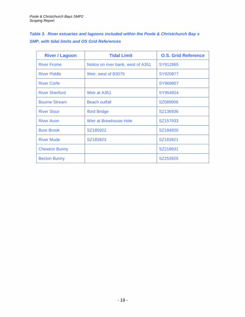
4.3.3 Table 3 lists river estuaries and lagoons which are to be included within the SMP, together with the location of their tidal limits.
4.3.4 The general principle that the SMP will include estuaries up to their tidal limit is a
change from the existing SMPs, which only extended to the coast protection limit.
- 18 -
Poole & Christchurch Bays SMP2 Scoping Report
Table 3. River estuaries and lagoons included within the Poole & Christchurch Bay s
SMP, with tidal limits and OS Grid References
River / Lagoon Tidal Limit O.S. Grid Reference
River Frome Notice on river bank, west of A351 SY912865
River Piddle Weir, west of B3075 SY920877
River Corfe SY969857
River Sherford Weir at A351 SY954924
Bourne Stream Beach outfall SZ089906
River Stour Iford Bridge SZ136936
River Avon Wier at Brewhouse Hole SZ157933
Bure Brook SZ185922 SZ184920
River Mude SZ183923 SZ183921
Chewton Bunny SZ218931
Becton Bunny SZ253925
- 19 -

Poole & Christchurch Bays SMP2 Scoping Report
5 Proposed scope of the SMP
5.1 DEFRA guidance for SMPs
5.1.1 The SMP review will be prepared generally in accordance with the March 2006 issue of Defra SMP guidance documents.
5.1.2 Although some elements of the guidance notes are contradictory, and others open
to interpretation, the guidance is considered by the Client Steering Group to be, in general, a sound basis on which to carry out the SMP2.
5.1.3 The brief for the SMP Consultant will be based upon the tasks and activities outlined
within the March 2006 Defra SMP documents. 5.2 Phases in the development of the SMP
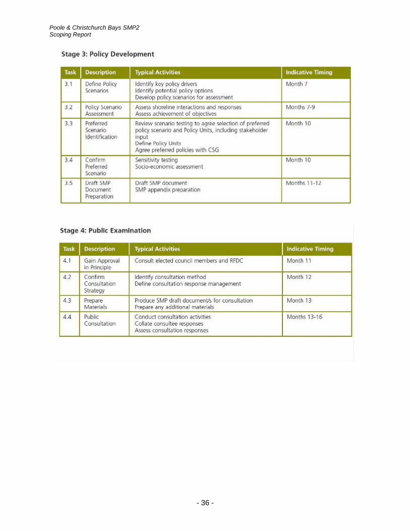
5.2.1 The key stages in developing the SMP defined by Defra guidance documents are as
follows:
. • Stage 1: scope the SMP
. • Stage 2: assistance to support policy development
. • Stage 3: policy development
. • Stage 4: public examination
. • Stage 5: finalise plan
. • Stage 6: plan dissemination 5.2.2 An overview of tasks for each of the stages, extracted from the guidance
documents, is given in the Appendices B and C. For detailed information reference should be made to the guidance documents themselves.
5.3 Interpretation of the Defra guidance 5.3.1 The Defra guidance documents, issued March 2006, have been followed in carrying
out the first stage of the review. 5.3.2 As the name suggests, the documents have been followed as guidance rather than
a prescriptive set of rules. 5.3.2 No two coastlines are the same with regard to stakeholders and, therefore, a
strategy for engaging with elected members and stakeholders on this particular review has been drawn up, which is summarised in Section 6.
5.4 Integration with existing management plans 5.4.1 The development of policies for the SMP review will need to consider existing
management plans and conservation objectives, including those associated with nature conservation designations.
- 20 -

Poole & Christchurch Bays SMP2 Scoping Report
5.4.2 Ideally, there should be no contradiction of management policy between the SMP and existing management plans within the same area, but the review should challenge the sustainability of previous policies.
5.4.3 Table 4 lists the existing management plans that will need to be taken into account.
Table 4. Existing management plans within the Poole & Christchurch Bays SMP.
Management Plan Format Location
Bournemouth, Christchurch, East Dorset, North Dorset & Salisbury SFRA
N/A N/A
Brownsea Island Management Plan N/A N/A
Christchurch Bay Strategy Study Hard copy /electronic
NFDC
Christchurch Beaches & Hinterland Management Plan
Hard copy CBC
Christchurch Harbour & Waterways Management Plan
Hard copy /electronic
EA / LAs
Christchurch Quay Management Plan
N/A CBC
Coastal Habitat Management Plan (CHaMPS) for Poole Harbour
N/A N/A
Dorset Area Outstanding Natural Beauty Management Plan
Electronic www.dorsetaonb.org.uk
Dorset and East Devon Coast World Heritage Site Management Plan
Electronic www.jurassiccoast.com/
Dorset Coast Strategy Electronic www.dorsetcoast.com
Dorset Local Geodiversity Action Plan
Electronic www.jurassiccoast.com
Durlston Bay Coastal Strategy Study
Hard Copy Natural England
Frome & Piddle Coastal Flood Management Plan
Environment Agency website
Hengistbury Head Management Plan 2005
Electronic BBC & www.twobays.net
- 21 -

Poole & Christchurch Bays SMP2 Scoping Report
Management Plan Format Location
Hurst Spit Beach Management Plan Electronic NFDC
Local Authority Local Plans
(NFDC / BBC / CBC / PDC / PBC)
Electronic Relevant LA websites
Mudeford Quay Management Plan Hard copy CBC
Mudeford Sandbank Management Plan
Hard copy CBC
New Forest SAC Management Plan Electronic www.newforestlife.org.uk
Planning Policy Guidelines PPS25 Electronic Communities & Local Government website
Poole Harbour SFRA N/A PBC
Poole & Christchurch Bays SMP1 Electronic www.twobays.net
Poole Bay & Harbour Strategy Study
Electronic www.poolebay.net
gement Plan Poole Harbour Aquatic Mana
Electronic www.pooleharbouraqmp.co.uk
Purbeck District Strategic Flood Risk Assessment
Electronic www.purbeck.gov.uk
River Frome Water Level Management Plan
Hard copy /electronic
Environment Agency
Seafront Strategy 2007-2011 Hard copy /electronic
BBC
The Dorset Stour Catchment Flood Management Plan
N/A N/A
Water Framework Directive www.defra.gov.uk/Environment/water/wfd/
- 22 -

Poole & Christchurch Bays SMP2 Scoping Report
5.5 Special issues for study area 5.5.1 Table 5 lists locations within the SMP area which are known from local knowledge,
and from discussions within the CSG to be particularly sensitive or contentious.
Table 5. Sensitive or contentious areas within the Poole & Christchurch Bays SMP
Location Designation Issue
Hengistbury Head SPA, SAC, LNR, SSSI
Possible breaching at Double Dykes through to Christchurch Harbour.
SSSI Poole Harbour Entrance • Loss of car park, beach huts, café and shop • Studland
• Brownsea • Grade 2 listed quayside buildings & development – long-term protection • Sandbanks
• Breaching and flooding
Arne Reedbeds, Bestwall (nr Wareham)
AONB, Heritage Coast, RSPB Reserve, RAMSAR, SPA, NNR, SSSI
Breaching of tidal banks & flooding of freshwater grazing marsh. Increased tidal locking of drainage systems. Loss of key ditch botanical interest features & potentially waterbird habitat. But opportunity for managed realignment to create saltmarsh/reedbed & maybe intertidal mudflats to replace those lost to sea-level rise inside existing harbour boundary.
- 23 -

Poole & Christchurch Bays SMP2 Scoping Report
5.6 Programme and progress on SMP2 to date
5.6.1 Defra high-level targets require the revised Shoreline Management Plans to be complete by March 2010.
5.6.2 Indicative timings of the different stages and tasks within the SMP review are given
by the Defra guidance documents, see Appendix B. 5.6.3 Tasks within “Stage 1: Scope the SMP”, as defined in the Defra guidance notes,
have been carried out by the Client Steering Group, and are summarised in Table 6.
Table 6. Summary of work carried out for Stage 1 of the SMP review
Task Description Work Carried Out
1.1 Initiate SMP • Client steering group membership decided upon. Organisational structure agreed upon and set up.
• Approach to producing SMP decided upon.
• Scope of work to produce the SMP decided upon.
1.2 SMP definition • SMP boundaries confirmed.
• Philosophy for inclusion of estuaries confirmed
1.3 Stakeholder engagement • Stakeholder engagement strategy defined.
• Stakeholders identified.
• Stakeholders contacted to inform them of SMP process.
• Database of registered stakeholders compiled
• Information leaflet prepared and distributed (see Appendix D).
• Website set up (www.twobays.net)
1.4 Data collation • Sources of data identified (in progress)
• Database of stakeholders holding information compiled (in progress)
1.5 Additional investigations • Desk study on requirements for additional investigations carried out.
- 24 -

Poole & Christchurch Bays SMP2 Scoping Report
6 Stakeholder engagement
6.1 Strategy
6.1.1 The stakeholder engagement process is intended to build trust and understanding between all parties involved in the formation of an SMP with the aim of being inclusive, transparent and appropriate in its methods and application. 6.1.2 The main groups involved in the review of the SMP are follows:
1. The Elected Members Group 2. The Client Steering Group 3. The Key Stakeholders Group 4. Other stakeholders 5. The SMP Consultant.
6.1.3 The membership of these groups, together with their roles and responsibilities, have
already been summarised in Section 3, and in Figure 1. 6.1.4 It is intended to involve elected member representatives in the production of the
SMP, principally through the Elected Members Group. One or two elected members, encompassing relevant portfolios, will be invited to participate from each of the local authorities within the Shoreline Management Plan area.
6.1.5 The Client Steering Group has overall responsibility for managing stakeholder
engagement. They organise meetings of the Elected Members Group and the Key Stakeholders Group and are the principal point of contact with other stakeholders.
6.1.6 The membership of the Key Stakeholders Group provides representation of the
primary interests within the study area. Group members will be involved through workshops and meetings and provide feedback information to the Client Steering Group.
6.1.7 The SMP consultants will have only limited engagement with stakeholders. The
Client Steering Group will be the principal point of contact for the Elected Members Group, the Key Stakeholders Group and other stakeholders. This is a departure from the approach commonly used in the first round of SMP's, in which the SMP Consultant had a substantial involvement in communicating with stakeholders.
6.1.8 It is considered that the Client Steering Group, with its local authority base,
substantial local contacts and established relationships, is better placed than a consultant to carry out the day-to-day stakeholder engagement functions. This leaves the SMP Consultant free to concentrate on the technical aspects of the SMP review and the provision of support to the Client Steering Group on stakeholder engagement, as and when requested.
- 25 -

Poole & Christchurch Bays SMP2 Scoping Report
6.2 Database of stakeholders 6.2.1 A database of stakeholders was developed during Spring 2008 as follows. 6.2.2 An initial consultation list of potential stakeholders was prepared using stakeholder
information from the Christchurch Bay and Poole Bay Strategy Studies, along with further information obtained through the Client Steering Group.
6.2.3 The preliminary stakeholder information was then combined into a merged database
of potential stakeholders (Appendix I) who were invited to participate in the SMP process through a mailshot (Appendix E). Those who replied to the invitation have been recorded as “registered stakeholders”.
6.2.4 A proportion of registered stakeholders have indicated that they hold data which
may be useful in the SMP process and a separate database of these stakeholder information sources is being maintained by the Client Steering Group (Appendix J).
6.2.5 Through this initial stakeholder engagement, stakeholders were asked to express an
interest if they wished to be considered for the Key Stakeholder Group. This preliminary list is in Appendix K.
6.2.6 The initial consultation list of potential stakeholders was not intended to be
comprehensive. For example, detailed land registry searches to identify coastal landowners have not been carried out, and neither have walkover surveys or house-to-house visits in an attempt to identify every possible potential stakeholder. Nonetheless, the lists compiled are considered to represent most of those individuals and organisations that are likely to have a serious interest in the SMP review.
- 26 -

Poole & Christchurch Bays SMP2 Scoping Report
7 Information for producing the SMP
7.1 Sources of information
7.1.1 As part of the scoping work carried out by New Forest District Council, the principal sources of information for producing the SMP have been identified and are listed in Table 7.
Table 7. Principal sources of data for the SMP review
Type Description Location
SMP1 for Poole & Christchurch Bays
• The original SMP lists sources of data which should be examined for the SMP review
Local Authority office & www.twobays.net
Sediment transport study • SCOPAC Sediment Transport Study www.scopac.org.uk
Coastal databases • The SCOPAC bibliographic database • Jurassic Coast database • Futurecoast • The Coast Protection Survey of England • The Dorset Coast Digital Archive • Poole Harbour Study Group Archive • NFCDD
Consulting engineers who are working on studies or schemes
• High-Point Rendel • Halcrow • HR Wallingford • Royal Haskoning • Mouchel
Coastal Observatories • Channel Coastal Observatory www.channelcoast.org
Files held at CSG member organisation offices
• NFDC • CBC • BBC • BOP • EA SW region • NE • NT • PHC • DCC
Registered stakeholders • See Appendix J of stakeholders holding information.
- 27 -

Poole & Christchurch Bays SMP2 Scoping Report
7.2 Data management
7.2.1 A key data management requirement is the recording of information used within the SMP. Appendix B of Defra guidance details the dataset requirements for the production of a SMP and advises that this should be cross-referenced to Appendix D, which provides details of sources for coastal behaviour and dynamics. A data request procedure is presented and links are provided to the Defra Flood Management website, where the full list of relevant datasets is described, together with contact details for the providers where a national provider for SMPs exists.
7.2.2 Any information gathered from stakeholders and others for use in the SMP
development should be properly referenced and recorded in a bibliographic database. The intention is for this to be adopted and expanded upon during the SMP review process.
7.2.3 In Volume 2 of the guidance, Task 1.4 (b) gives information on good data
management practice, but advises that no national coastal metadatabase product is available to support SMPs. Task 1.4 (c) advises that further review of data may be required in the pursuit of baseline understanding of coastal behaviour and dynamics.
- 28 -

Poole & Christchurch Bays SMP2 Scoping Report
8 Additional Investigations
8.1 DEFRA guidance
8.1.1 One of the tasks recommended by the Defra guidance documents under Stage one: scope the SMP, is to undertake further studies to provide information necessary for the review of the SMP.
8.2 Desktop appraisal 8.2.1 A desktop appraisal has been carried out by the Client Steering Group using the
DEFRA guidance, which reviewed recommendations on additional studies and investigations made in the original SMP1 for Poole & Christchurch Bays.
8.2.2 In the time since the completion of SMP1, there has been varying success in
fulfilling these recommendations, because of constraints on funding and staff resources in operating authorities.
8.2.3 Essentially for those recommended investigations and studies that have not already
been undertaken, or initiated, there are unlikely to be available funds in the short term, or time within the programme for development of SMP2, to provide any additional information to fill any data gaps for these areas.
8.2.4 A summary of the desk top appraisal is included as Appendix F.
- 29 -

Poole & Christchurch Bays SMP2 Scoping Report
9 Environmental Assessments
9.1 Strategic Environmental Assessment (SEA)
9.1.1 Since SMPs are high level strategic planning documents, a full Environmental Impact Assessment and production of an Environmental Statement would not be appropriate.
9.1.2 The Strategic Environmental Assessment (SEA) Directive (EC Directive 2001/42)
sets out requirements for the assessment of the effects of certain plans and programmes on the environment.
9.1.3 The letter to operating authorities of 16 September 2004 from Defra’s Head of Flood
Management Division states that there is no legal requirement to apply the SEA Directive to SMPs, CFMPs and Strategies. However, since SMPs, CFMPs and Strategies clearly help to set the framework for future planning and have significant environmental implications, Defra strongly encourages the operating authorities to undertake SEA for SMPs.
9.1.4 Trial SMP2s have followed SEA guidance and determined that the principles of SEA
are embedded within Defra’s revised SMP2 guidance. Defra believe, therefore, that work to develop the SEA should not add significant costs to the cost of preparing the SMP2. It is, therefore, proposed to undertake SEA as an integrated part within the SMP2 technical studies being commissioned.
9.2 Appropriate Assessment (AA) 9.2.1 Defra (2006) included a note which has been agreed between Defra and the
Environment Agency’s legal advisors to provide assistance when considering whether an AA is necessary under Article 6 of the Habitats Directive.
9.2.2 It would appear that if an AA is required, then this should be done at a level
appropriate to the wide ranging scale of SMPs. It should take account of the fact that more detailed environment assessments will be done at the strategy and scheme/project stage and as the identification of any adverse effect becomes similarly more definite, so the identification of a need for compensatory measures can be firmed up.
9.2.3 It is considered that an AA is required for this study, at the wide ranging scale
indicated above. Through the North Solent & Mainland SMP2 Review a suitable AA methodology is being developed with NE and the EA. It would be appropriate to wait until this has been finalized and agreed before progressing the commissioning of the AA.
9.2.4 Further notes prepared by the South Devon & Dorset SMP Project Management Group on the need and process for AA are given in Appendix L.
- 30 -

Poole & Christchurch Bays SMP2 Scoping Report
References
Defra (2006). Shoreline management plan guidance (Volumes 1, 2 and appendices).
Halcrow (2001). Shoreline Management Plans: advice on key boundary locations. Internal report for English Nature.
Halcrow (2002). The Futurecoast Study - interactive CD-ROM.
Halcrow (1999). Poole and Christchurch Bays Shoreline Management Plan.
- 31 -

Poole & Christchurch Bays SMP2 Scoping Report
Appendices
Appendix A: Abbreviations and acronyms
Appendix B: Overview of tasks from Defra SMP Guidelines
Appendix C: SMP workflow plan from Defra SMP Guidelines
Appendix D: SMP2 information leaflet
Appendix E: Forms and letters issued to potential stakeholders
Appendix F: Summary of investigations recommended by SMP1
Appendix G: Natural England designated sites
Appendix H: Details of principal contacts
Appendix I: List of stakeholders invited to participate in SMP review
Appendix J: Database of data held by stakeholders
Appendix K: List of stakeholders expressing an interest in joining the KSG Appendix L: Notes on Appropriate Assessment - the need and process Appendix M: Map of SMP area
- 32 -

Poole & Christchurch Bays SMP2 Scoping Report
Appendix A: Abbreviations and acronyms
AA Appropriate Assessment
AONB Area of Outstanding Natural Beauty
BBC Bournemouth Borough Council
BOP Borough of Poole
CCO Channel Coastal Observatory
CBC Christchurch Borough Council
CD Chart Datum
CFMP Catchment Flood Management Plan
CPSE Coast Protection Survey England
CSG Client Steering Group
DCC Dorset County Council
DCF Dorset Coast Forum
DEFRA Department for Environment, Food and Rural Affairs
EA Environment Agency
EH English Heritage
GCR Geological Conservation Review site
GIS Geographic Information System
HAT Highest Astronomical Tide
HCC Hampshire County Council
HER Historic Environment Record
HLT High Level Target
ICZM Integrated Coastal Zone Management
KSG Key Stakeholders Group
LAT Lowest Astronomical Tide
MAFF Ministry of Agriculture Fisheries and Food (now DEFRA)
MHWN Mean High Water Neap tide
MHWS Mean High Water Spring tide
MLWN Mean Low Water Neap tide
MLWS Mean Low Water Spring tide
- 33 -

Poole & Christchurch Bays SMP2 Scoping Report
MSL Mean Sea Level
MU Management Unit
NE Natural England
NFCDD National Flood and Coastal Defence Database
NFDC New Forest District Council
NMR National Monuments Record
NT National Trust
PDC Purbeck District Council
PHC Poole Harbour Commissioners
PPG Planning Policy Guidance
PSA Public Service Agreement
PU Policy Unit
RCZAS Rapid Coastal Zone Assessment Survey
SAC Special Area of Conservation
SCOPAC Standing Conference on Problems Associated with the Coastline
SEA Strategic Environmental Assessment
SMP Shoreline Management Plan
SMP1 A first-round Shoreline Management Plan
A second-round Shoreline Management Plan SMP2
Sites and Monuments Record SMR
Special Protection Area SPA
Site of Special Scientific Interest SSSI
- 34 -

Poole & Christchurch Bays SMP2 Scoping Report
Appendix B: Overview of tasks from Defra SMP Guidelines
- 35 -
Poole & Christchurch Bays SMP2 Scoping Report
- 36 -

Poole & Christchurch Bays SMP2 Scoping Report
- 37 -

Poole & Christchurch Bays SMP2 Scoping Report
Appendix C: SMP workflow plan from Defra SMP Guidelines
- 38 -

Poole & Christchurch Bays SMP2 Scoping Report
Appendix D: SMP2 information leaflet
Follow the link http://www.twobays.net/consultation.htm for a full copy of the leaflet.
- 39 -

Poole & Christchurch Bays SMP2 Scoping Report
Appendix E: Questionnaire and letters sent to potential stakeholders
- 40 -

Poole & Christchurch Bays SMP2 Scoping Report
- 41 -

Poole & Christchurch Bays SMP2 Scoping Report
- 42 -

Poole & Christchurch Bays SMP2 Scoping Report
- 43 -
Poole & Christchurch Bays SMP2 Scoping Report
- 44 -

Poole & Christchurch Bays SMP2 Scoping Report
- 45 -

Poole & Christchurch Bays SMP2 Scoping Report
E1 Invitation letter to large organisations that are familiar with the SMP process and were probably involved in the first generation of plans
- 46 -

Poole & Christchurch Bays SMP2 Scoping Report
- 47 -

Poole & Christchurch Bays SMP2 Scoping Report
E2 Invitation letter to other organisations or businesses who may not be familiar with SMPs but to whom a more formal approach should be made
- 48 -

Poole & Christchurch Bays SMP2 Scoping Report
- 49 -

Poole & Christchurch Bays SMP2 Scoping Report
E3 Invitation letter to the general public, individual landowners and small businesses that need to have the SMP process explained to them
- 50 -

Poole & Christchurch Bays SMP2 Scoping Report
- 51 -

Poole & Christchurch Bays SMP2 Scoping Report
Appendix F: summary of investigations recommended by SMP1
The following is a desk top review of the recommendations for further monitoring, studies and research contained in the current documentation for the Poole & Christchurch Bays SMP [Task 1.2(b)]. These activities were recommended to fill gaps in, and improve, where identified, our understanding of the coastal environment and reduce uncertainties which were inherent during SMP1 policy development. There has been varying success in fulfilling these recommendations, and this is understandable given constraints on funding and staff resources in operating authorities.
a) Future Monitoring
Beach Profile Surveys - As stated in the documentation, coastal process monitoring is generally accepted as a key component in the effective management of the shore and underpins strategic studies and research. SMP1 made recommendations that a “comprehensive set of beach profiles should be obtained on a bi-annual basis at specific locations.” This survey work has been implemented through the Southeast Strategic Regional Coastal Monitoring Programme, which is now in year six of a programme currently approved to run until 2012. All data produced through this programme is freely available through the Channel Coastal Observatory website (www.channelcoast.org) and is used to inform development of future strategy studies, SMPs and coast protection schemes.
River Surveys – Recommendations were made that additional monitoring be undertaken on the rivers Frome and Piddle, in the form of annual cross-channel profiles. As part of the Purbeck Keystone Project (at Purbeck District Council) a team of consultants has been engaged in a water level management feasibility study. This has involved the recording of several river cross-sectional profiles on the lower Frome between East Stoke and Wareham and the development of a hydrodynamic model that predicts flooding in that stretch of the river valley (final report due shortly).
Saltmarsh Surveys – SMP1 recommended that additional information on saltmarsh change, within Poole Harbour be gathered through profile surveys of key locations, along with mapping of vegetation communities, with a view to establishing good baseline data to enable future change to be measured. In response to this a number of surveys have been completed: The Poole Harbour Reedbed Survey 2000 was published by the Poole Harbour Study Group Feb 2001(author Kevin Cook); The Vegetation of Poole Harbour published by the Poole Harbour Study Group 2004 (author Brian Edwards); Further saltmarsh survey work has recently been undertaken by the EA as part of their Water Framework Directive monitoring programme.
Bathymetric Profile Surveys – In line with the beach profile surveys, the recommendation was to gather further bathymetric data through regular bathymetric surveys. This additional data collection has been undertaken through the Southeast Strategic Regional Coastal Monitoring Programme.
- 52 -

Poole & Christchurch Bays SMP2 Scoping Report
Defence Condition Surveys – The recommendation was to implement a regular inspection regime to determine defence condition and residual life. There had been limited progress made on this proposal until 2007. Asset inspections were made of all defences within Christchurch Bay in 2003 for the Christchurch Bay Strategy Study. However, with the recent implementation of NFCDD and the need to populate the database to meet Defra High Level Targets all defences within the SMP area are likely to be inspected throughout 2008.
Wave Conditions – The recommendations of SMP1 have been meet through the development and implementation of the Southeast Strategic Regional Coastal Monitoring Programme, with the deployment of a waverider buoy at Boscombe in 2003. Deployment of the Milford waverider buoy has continued since SMP1, with data from both buoys being available on the Channel Coast website. Additionally a wave/tide gauge was deployed at Swanage Pier in the early part of 2007, again as part of the regional monitoring programme.
Water Level Conditions – Through the Southeast Strategic Regional Coastal Monitoring Programme additional instrumentation has been deployed to gather tidal date. This is through the instrument at Swanage Pier, along with the replacement of the instrumentation at Lymington. Through POL there has also been the deployment of a tide gauge at Bournemouth.
Cliff Monitoring – SMP1 highlighted that Barton-on-Sea and Swanage are affected by groundwater issues and that monitoring instrumentation such as piezometers and inclinometers be used to gather suitable data, along with other measures to enable ground movement to be monitored. At Barton monitoring has included:-
• Piezometers
• Inclinometers
• Basic flow monitoring of the cliff drainage system
• Monthly surveying of set points to monitor position change
• LiDAR surveys are also undertaken through the regional monitoring programme
A cliff survey has been carried out at Swanage by the Channel Coastal Observatory as part of the SE Strategic Coastal Monitoring Programme.
- 53 -

Poole & Christchurch Bays SMP2 Scoping Report
Data Storage and Monitoring Co-ordination – The recommendations from SMP1 have been implemented through the regional monitoring programme. All survey data is archived with full metadata, through a central data centre (www.channelcoast.org) and data is gathered to a standard specification across the whole frontage.
b) Further Studies and Data Requirements
Water Level Variation – Both steps suggested by SMP1 have been implemented. SCOPAC commissioned a Tidal Research Project primarily for the purpose of observation and forecasting of episodic surges in sea level along the SCOPAC coastline. The report, undertaken by Southampton Oceanography Centre, was completed in November 2003 and included a detailed metadatabase of all gauges in the area, with an assessment of their quality. The report's key recommendations included:
• Additional sea level gauges at high priority sites (Bosham, Hermitage, Totland and Ventnor), with all gauges being operated to GLOSS standards. Secondary priority sites were Beaulieu, Lyme Regis, Pagham Harbour and Swanage
• Digitisation of suitable historic chart data to provide longer-term data sets for surge analysis
Since then, the Southeast and Southwest Regional Monitoring Programmes have deployed new tide gauges at Sandown (covering Ventnor), Swanage and West Bay (covering Lyme Regis), and replaced the tide gauge on the RLYC Starting Platform at Lymington. These new gauges were designed to fill in some of the gaps identified by the SCOPAC tidal research report. The recommendation for a gauge at Totland has not been fulfilled due to a lack of suitable infrastructure. The recommendations of both the SCOPAC report and SMP1 regarding data quality and management have been implemented by the Regional Monitoring Programmes; their new gauges are operated to GLOSS standards, the data are quality-controlled to European Sea Level Service protocols and the data are archived with full metadata and made freely available.
Wave Refraction Analysis – There has been no further, systematic wave refraction modelling along the SCOPAC coastline, although nearshore directional waverider buoys have been deployed by the Regional Monitoring Programme at Milford-on-Sea and Boscombe and further offshore by Wavenet. These provide good-quality data for wave refraction modelling, and the intention is that the buoys will remain in place long-term to provide more reliable statistics for nearshore wave climate and extremes prediction.
Archeology Review – Following the recommendations from SMP1 a comprehensive study of Poole Harbour’s heritage is currently being undertaken by the Poole Harbour Heritage Project with the aim of extending the available archaeological information.
Improve Assessment of Current Defence Standards – in-hand through NFCDD inspections
- 54 -

Poole & Christchurch Bays SMP2 Scoping Report
Increasing Understanding of Future Changes in Poole Bay – No action to date.
Quantification of sediment exchange between the open coast and Hook Sands – No action to date.
Poole Bay Beach Management plan – The Poole Bay & Harbour Strategy Study which assessed flood and coast defence options and followed on from the SMP1. The Strategy Study & further reports by Halcrow identified the requirements, mechanism and programme for coordinated beach nourishment schemes at Swanage & between Poole Sandbanks & Hengistbury Head. These schemes were subsequently undertaken between 2005 & 2007.
Managed Retreat – The Poole and Christchurch Dynamic Coast Project is currently being conducted by New Forest District Council / Channel Coastal Observatory. The project will inform development of the SMP2 in order to comply with the requirements of the European Union Habitats and Birds Directives. The main objective of the project is to quantify inter-tidal loss and identify potential for re-creation at a strategic level. Using approximate benefit-cost calculations the project will categorise potential inter-tidal habitat creation sites into possible managed re-alignment sites, possible abandonment sites (No Active Intervention) and possible hold the line sites.
Studland Bay Shoreline Evolution Study – Following the recommendations in SMP1, the shoreline evolution of Studland Bay was assessed in the Poole Bay & Harbour Strategy Study 2004. In addition there is also the Studland Bay Management Plan – Managing Realignment Commissioned by the National Trust (Halcrow 2006). A number of reports have assessed the condition of the gabion sea defences at Middle Beach between 2001 & 2008 (Royal Haskoning).
Increase Understanding of Future Changes in Christchurch Bay –
Quantification of Future Evolution at Naish Farm – SMP1 stated that quantification of the future evolution at Naish Farm was required. The Christchurch Bay Strategy Study considered shoreline evolution at this site and the coastline between Chewton Bunny & Becton Bunny. By using ortho-rectified aerial photography, future recession rates were identified & mapped.
Beach Management Plan for Christchurch Bay – The Christchurch Bay Strategy Study further identified the need for a Beach Management Plan for Christchurch Bay. Coordinated monitoring and data storage has now been implemented through the regional monitoring programme. All survey data is held through a central data centre (www.channelcoast.org).
- 55 -

Poole & Christchurch Bays SMP2 Scoping Report
Appendix G: Natural England designated sites
G1 Sites of Special Scientific Interest
Site Code Name Area (Ha)
1000423 Highcliffe to Milford Cliffs 110.09
1000427 Hurst Castle & Lymington River Estuary (part) 1077.45
1000579 Avon Valley 1403.81
1001051 Poole Bay Cliffs 12.31
1001109 The Moors 157.88
1001140 Arne 557.6
1001148 South Dorset Coast 1591.68
1001205 Poole Harbour 2268.63
1001214 Studland Cliffs 21.11
1001312 Ham Common 32.92
1001326 Hartland Moor 301.3
1001338 Rempstone Heaths 169.93
1001340 Wareham Meadows 210.89
1006212 Studland & Godlingston Heaths 758.83
1006213 Luscombe Valley 57.96
1006333 River Frome 151.45
1006597 River Avon system 475.94
1006637 Purbeck Ridge 143.59
1006727 Holton & Sandford Heaths 277.16
1008950 Christchurch Harbour 352.14
- 56 -

Poole & Christchurch Bays SMP2 Scoping Report
G2 Special Areas of Conservation
Site Code Name Area (Ha)
UK0030059 Solent Maritime 11243.38
UK0013016 River Avon 467.58
UK0019857 Dorset Heaths 5719.54
UK0019861 Isle of Portland to Studland Cliffs 1446.45
UK0019863 St Albans Head to Durlston Head 284.68
UK0030038 Dorset Heaths (Purbeck & Wareham) & Studland Dunes 2231.75
G3 Ramsar Sites
Site Code Name Area (Ha)
UK11005 Avon Valley 1390.41
UK11021 Dorset Heathlands 6682.33
UK11054 Poole Harbour 2480.21
G4 Special Protection Areas
Site Code Name Area (Ha)
UK9010101 Dorset Heathlands 8173.82
UK9010111 Poole Harbour 2313.57
UK9011091 Avon Valley 1351.1
- 57 -

Poole & Christchurch Bays SMP2 Scoping Report
G5 National Nature Reserve
Site Code Name Area (Ha)
1006004 Arne Reedbeds 9.57
1006071 Hartland Moor 244.54
1006138 Studland & Godlingston Heaths 624.76
G6 Local Nature Reserve
Site Code Name Area (Ha)
Boscombe to Southbourne Overcliff 9
1008832 Branksome Dene Chine 4.75
1008950 Hengistbury Head 154.77
1009166 Stanpit Marsh 54.97
- 58 -

Poole & Christchurch Bays SMP2 Scoping Report
Appendix H: Details of principal contacts
Name Details
Dr David Harlow Coast Protection Manager Bournemouth Borough Council Tel: 01202 451389 E-mail: [email protected]
Steve Cook Assistant Engineer New Forest District Council Tel: 02380 285648 E-mail: [email protected]
Steve Woolard Senior Engineer – Coast Protection Manager Christchurch Borough Council Tel : 01202 495095 E-mail: [email protected]
Andrew Gill Flood Risk Mapping & Data Management Team Leader Environment Agency Tel : 01258 483356 E-mail: [email protected]
Tony Flux Dorset Coastal Zone Project Manager National Trust Tel: 07919 585859
E-mail: [email protected]
Richard Caldow Maritime Advisor Natural England Tel: 01929 557481
E-mail: [email protected]
- 59 -

Poole & Christchurch Bays SMP2 Scoping Report
Dave Robson Senior Engineer
Borough of Poole
Tel : 01202 261306
E-mail: [email protected]
Andy Ramsbottom Harbour Engineer
Poole Harbour Commissioners
Tel : 01202 440234
E-mail : [email protected]
Mike Goater District Engineer
Purbeck District Council
Tel : 01929 557271
E-mail: [email protected]
- 60 -

Poole & Christchurch Bays SMP2 Scoping Report
Appendix I: List of Stakeholders invited to participate in SMP review
I1. The following is a list of all the stakeholders (597 no. in total) who were invited to participate in the SMP process through the mailshot (Appendix E) or have responded through the website www.twobays.net (as of 10/07/2008): (See http://www.twobays.net/stakeholder_list.htm for updated list) Affpuddle & Turnerspuddle Parish Council
Alderney East & Rossmore Residents Association
Arne Parish Council
ARUBA Bar & Restaurant
Ashley Cross Residents Association
Associated British Ports
Avon Beach Company
Baiter Park Residents Association
Barbers Wharf Management Ltd
Barbers Wharf Residents Association
Barker Mills Estate
Barton-on-Sea Golf Club
Beachcomber Café
Bere Regis Parish Council
Bistro on the Beach
Bloxworth Parish Meeting
Bourne Leisure Ltd, Rockley Park
Bournemouth and West Hampshire Water Company Plc
Bournemouth Boating Services
Bournemouth Borough Council
Bournemouth Borough Council (Environment Portfolio Holder)
Bournemouth Borough Councillor (Boscombe East Ward)
- 61 -

Poole & Christchurch Bays SMP2 Scoping Report
Bournemouth Borough Councillor (Boscombe West Ward)
Bournemouth Borough Councillor (Central Ward)
Bournemouth Borough Councillor (East Cliff & Springbourne Ward)
Bournemouth Borough Councillor (East Southbourne & Tuckton Ward)
Bournemouth Borough Councillor (Kinson North Ward)
Bournemouth Borough Councillor (Kinson South Ward)
Bournemouth Borough Councillor (Littledown and Iford Ward)
Bournemouth Borough Councillor (Moordown Ward)
Bournemouth Borough Councillor (Queens Park Ward)
Bournemouth Borough Councillor (Redhill and Northbourne Ward)
Bournemouth Borough Councillor (Strouden Park Ward)
Bournemouth Borough Councillor (Talbot and Branksome Woods Ward)
Bournemouth Borough Councillor (Throop and Muscliff Ward)
Bournemouth Borough Councillor (Wallisdown and Winton West Ward)
Bournemouth Borough Councillor (West Southbourne Ward)
Bournemouth Borough Councillor (Westbourne and West Cliff Ward)
Bournemouth Borough Councillor (Winton East Ward)
Bournemouth Chamber of Commerce
Bournemouth Pier
Bournemouth Pier Complex / Openwide Ltd
Bournemouth Surf School
Bournemouth Surfing Centre
Bournemouth University (Department of Conservation Sciences)
Boyd Northmere Residents Association
BP Exploration
Branksome Dene Residents Association
Branksome Park, Canford Cliffs & District Residents Association
- 62 -

Poole & Christchurch Bays SMP2 Scoping Report
Branksome Residents Association
Branksome Towers Residents Association
British Disabled Water Ski Association
British Geological Survey (Coastal Geology Group Nottingham)
British Herpetological Society
British Institute for Geological Conservation
British Marine Aggregate Producers Association
British Oceanography Data Centre
British Telecom
Broadstone Residents Association
Broom Road Residents Association
Canford Cliffs Land Society
Canford Heath Residents Association
CEFAS
Centre for Ecology and Hydrology
Chaddesley Ridge Residents Association
Chairman, Poole Sports Council
Chaldon Herring Parish Council
Christchurch Angling Club
Christchurch Boardsailing Club
Christchurch Borough Council
Christchurch Borough Council (Environment Portfolio Holder)
Christchurch Borough Councillor (Burton and Winkton Ward)
Christchurch Borough Councillor (Grange Ward)
Christchurch Borough Councillor (Highcliffe Ward)
Christchurch Borough Councillor (Highcliffe Ward)
Christchurch Borough Councillor (Jumpers Ward)
- 63 -

Poole & Christchurch Bays SMP2 Scoping Report
Christchurch Borough Councillor (Mudeford and Friars Cliff Ward)
Christchurch Borough Councillor (North Highcliffe and Walkford Ward)
Christchurch Borough Councillor (Portfield Ward)
Christchurch Borough Councillor (Purewell and Stanpit Ward)
Christchurch Borough Councillor (St Catherine’s and Hurn Ward)
Christchurch Borough Councillor (Town Centre Ward)
Christchurch Borough Councillor (West Highcliffe Ward)
Christchurch Chamber of Commerce
Christchurch Ornithological Group
Christchurch Rowing Club
Christchurch Sports Council
Christchurch Windsurfing Club
Church Knowle Parish Council
Cliff House Hotel
Coasters
Coombe Keynes Parish Meeting
Corfe Castle Parish Council
Council for the Protection of Rural England (Dorset Branch)
Council for the Protection of Rural England (Hampshire Branch)
Country Land & Business Association
Country Landowner’s Association
Creekmoor Community Group
Crosons Passenger Boats
Crown Estates (Dorset Marine)
Crown Estates (Hampshire Marine)
Defence Estate Organisation
DEFRA (Countryside Division)
- 64 -
Poole & Christchurch Bays SMP2 Scoping Report
DEFRA (Fisheries Office)
DEFRA (Government Office for the South West)
DEFRA (Government Office for the South West)
DEFRA (Regional Engineer)
DEFRA (Rural Development Service)
DEFRA (Rural Development Service)
Department for Culture Media & Sport
Department for Transport (Ports Division)
Disabled Drivers Association
Disabled Swimmers Club (Bournemouth)
Dorset Archaeological Unit
Dorset Bird Club
Dorset Business Chamber of Commerce
Dorset Coast Forum
Dorset Conservation & Environment Record Centre
Dorset County Council
Dorset County Council
Dorset County Council (Heritage Coast)
Dorset County Councillor (Blackmore Vale Division)
Dorset County Councillor (Blandford Division)
Dorset County Councillor (Bride Valley Division)
Dorset County Councillor (Burton Grange Division)
Dorset County Councillor (Christchurch Central Division)
Dorset County Councillor (Colehill & Stapehill Division)
Dorset County Councillor (Commons Division)
Dorset County Councillor (Corfe Mullen Division)
Dorset County Councillor (Egdon Heath Division)
- 65 -

Poole & Christchurch Bays SMP2 Scoping Report
Dorset County Councillor (Ferndown Division)
Dorset County Councillor (Highcliffe & Walkford Division)
Dorset County Councillor (Linden Lea Division)
Dorset County Councillor (Lodmoor Division)
Dorset County Councillor (Lytchett Division)
Dorset County Councillor (Mudeford & Highcliffe Division)
Dorset County Councillor (Purbeck Hills Division)
Dorset County Councillor (Rodwell Division)
Dorset County Councillor (St Leonards and St Ives Division)
Dorset County Councillor (Stour Vale Division)
Dorset County Councillor (Swanage Division)
Dorset County Councillor (Three Valleys Division)
Dorset County Councillor (Verwood & Three Legged Cross Division)
Dorset County Councillor (Wareham Division)
Dorset County Councillor (West Moors & Holt Division)
Dorset County Councillor (Winterborne Division)
Dorset Cruises Limited
Dorset Diving Services
Dorset Federation of Residents Association
Dorset Geologists Association
Dorset Lake Association
Dorset Lake Shipyard (representing Poole Harbour Commercial Users)
Dorset Natural History and Archaeological Society
Dorset Ramblers Association
Dorset Trust for Nature Conservation
Dorset Wildlife Trust
Drake Court Residents Association
- 66 -

Poole & Christchurch Bays SMP2 Scoping Report
Durley Inn
Durlston Coastwatch
Durlston Country Park
EA Defence Committee
East Cliff Café
East Dorset County Councillor (Alderholt Ward)
East Dorset County Councillor (Ameysford Ward)
East Dorset County Councillor (Colehill West Ward)
East Dorset County Councillor (Corfe Mullen Central Ward)
East Dorset County Councillor (Corfe Mullen North Ward)
East Dorset County Councillor (Corfe South Ward)
East Dorset County Councillor (Ferndown Central Ward)
East Dorset County Councillor (Ferndown Links Ward)
East Dorset County Councillor (Handley Vale Ward)
East Dorset County Councillor (Longham Ward)
East Dorset County Councillor (Parley Ward)
East Dorset County Councillor (St Leonards & St Ives East Ward)
East Dorset County Councillor (St Leonards & St Ives West Ward)
East Dorset County Councillor (Verwood Dewlands Ward)
East Dorset County Councillor (Verwood Newtown Ward)
East Dorset County Councillor (Verwood Stephen’s Castle Ward)
East Dorset County Councillor (West Moors Ward)
East Holme Parish Meeting
East Lulworth Parish Council
East Stoke Parish Council
Elms Estate Association
Engineering & Physical Sciences Research Council
- 67 -

Poole & Christchurch Bays SMP2 Scoping Report
English Heritage (South East Region)
English Heritage (South West Region)
Environment Agency (South West Region)
Environment Agency (Southern Region)
Environment Agency (Wessex Region)
Environment Agency Defence Committee
Farming and Wildlife Advisory Group (Dorset)
Farming and Wildlife Advisory Group (Hampshire)
FPD Savilles
Friars Cliff Beach Hut Association
Friars Cliff Residents’ Association
Friends of the Earth
Greenbalance
Hampshire & Isle of Wight Wildlife Trust
Hampshire & Wight Trust for Maritime Archaeology
Hampshire County Council
Hampshire County Council (Planning Dept)
Hampshire County Council (Project)
Hampshire Field Club & Archaeological Society
Hampshire Ramblers Association
Hamside Residents Association
Hamworthy Harbourside Residents Association
Harbourside Residents Association
Harry Ramsdens (Bournemouth)
Heckford Park Residents Association
Hengistbury Head Residents Association
Hengistbury Head Warden
- 68 -

Poole & Christchurch Bays SMP2 Scoping Report
Herpetological Conservation Trust
Highcliffe Residents Association
Highcliffe Sailing Club
Hiker Café
Hoburne Ltd
Holes Bay Residents Association
Hordle Manor Farm
Hordle Vision Group
Hot Rocks Surf Bistro
Hurn Sub Aqua Club
Hydraulic Research Ltd (Wallingford)
ICE Library (London)
Joint Committee of Christchurch Resident’s Associations
Joint Nature Conservation Committee
Jubilee Road Residents’ Association
Kimmeridge Parish Meeting
Kings College London
Knowlton Road Residents Association
Lake Residents Association
Langton Matravers Parish Council
Lymington and Pennington Town Council
Lymington Yacht Club
Lytchett Matravers Parish Council
Lytchett Minster & Upton Town Council
Lytchett Minster and Upton Town Council
Manor Avenue Residents Association
Marine & Fisheries Agency
- 69 -

Poole & Christchurch Bays SMP2 Scoping Report
Marine Conservation Society
Maritime and Coastguard Agency
Member of Parliament (Bournemouth East)
Member of Parliament (Bournemouth West)
Member of Parliament (Christchurch)
Member of Parliament (Mid Dorset & Poole North)
Member of Parliament (New Forest West)
Member of Parliament (Poole)
Member of Parliament (South Dorset)
Meteorological Office
Meyrick Estate Management Ltd
Milford-on-Sea Beach Hut owners Association
Milford-on-Sea Environment Group
Milford-on-Sea Historical Record Society
Milford-on-Sea Parish Council
Milford-on-Sea Wildlife Recording Group
Morden Parish Council
Moreton Parish Council
Mudeford and District Fisherman’s Association
Mudeford Beach Huts
Mudeford Ferry and Adventure Voyages
Mudeford Sailing Club
Mudeford Sandbank Beach Hut Association
Mudeford Sandbanks News
Mudeford-4-U
Naish Chalet and Caravan Owners Association
National Environment Research Council
- 70 -

Poole & Christchurch Bays SMP2 Scoping Report
National Farmers Union (South East Region)
National Farmers Union (South West Region)
National Monuments Record Centre
National Trust (Brownsea Island)
National Trust (Countryside Office)
National Trust (Dorset Estates Office)
National Trust (Regional Conservation Advisor)
National Trust (Wessex Region)
Natural England (South East Region)
Natural England (South West Region)
Needles Eye Café
Needles Point Management Company Ltd
Neptune Inn
New Forest District Council (Environment Portfolio Holder)
New Forest District Councillor (Ashurst, Copythorne South and Netley Marsh Ward)
New Forest District Councillor (Barton Ward)
New Forest District Councillor (Bashley Ward)
New Forest District Councillor (Becton Ward)
New Forest District Councillor (Boldre and Sway Ward)
New Forest District Councillor (Bramshaw, Copythorne North and Minstead Ward)
New Forest District Councillor (Bransgore and Burley Ward)
New Forest District Councillor (Brockenhurst and Forest South East Ward)
New Forest District Councillor (Buckland Ward)
New Forest District Councillor (Butts Ash and Dibden Purlieu Ward)
New Forest District Councillor (Dibden and Hythe East Ward)
New Forest District Councillor (Downlands and Forest Ward)
New Forest District Councillor (Fawley, Blackfield and Langley Ward)
- 71 -

Poole & Christchurch Bays SMP2 Scoping Report
New Forest District Councillor (Fernhill Ward)
New Forest District Councillor (Fordingbridge Ward)
New Forest District Councillor (Forest North West Ward)
New Forest District Councillor (Furzedown and Hardley Ward)
New Forest District Councillor (Holbury and North Blackfield Ward)
New Forest District Councillor (Hordle Ward)
New Forest District Councillor (Hythe West and Langdown Ward)
New Forest District Councillor (Lymington Town Ward)
New Forest District Councillor (Lyndhurst Ward)
New Forest District Councillor (Marchwood Ward)
New Forest District Councillor (Milford Ward)
New Forest District Councillor (Milton Ward)
New Forest District Councillor (Pennington Ward)
New Forest District Councillor (Ringwood East and Sopley Ward)
New Forest District Councillor (Ringwood North Ward)
New Forest District Councillor (Ringwood South Ward)
New Forest District Councillor (Totton Central Ward)
New Forest District Councillor (Totton East Ward)
New Forest District Councillor (Totton North Ward)
New Forest District Councillor (Totton South Ward)
New Forest District Councillor (Totton West Ward)
New Forest National Park Authority
New Forest Ramblers Association
New Milton Residents’ Association
New Milton Residents’ Association
New Milton Town Council
New Talbot Village Residents Association
- 72 -

Poole & Christchurch Bays SMP2 Scoping Report
NFDC Beach Hut Owners Group
Ocean Youth Trust – South
Open Spaces Society
Orchard Area Residents Association
Ordnance Survey
Parkstone Bay Association
Parkstone District Residents & Tenants Association
Pebble Beach Restaurant
Phyldon Close Residents Association
Pier Approach Oceanarium
Plymouth University (Centre for Coastal Zone Management)
Poole & District Fisherman Association
Poole Agenda 21 Forum
Poole Association for the Disabled
Poole Bay Archaeological Research Group
Poole Borough Council (Environment Portfolio Holder)
Poole Borough Councillor (Alderney Ward)
Poole Borough Councillor (Branksome East Ward)
Poole Borough Councillor (Branksome West Ward)
Poole Borough Councillor (Broadstone Ward)
Poole Borough Councillor (Canford Cliffs Ward)
Poole Borough Councillor (Canford Heath East Ward)
Poole Borough Councillor (Canford Heath Ward)
Poole Borough Councillor (Canford Heath West Ward)
Poole Borough Councillor (Creekmoor Ward)
Poole Borough Councillor (Hamworthy East Ward)
Poole Borough Councillor (Hamworthy West Ward)
- 73 -

Poole & Christchurch Bays SMP2 Scoping Report
Poole Borough Councillor (Merley & Bearwood Ward)
Poole Borough Councillor (Newtown Ward)
Poole Borough Councillor (Oakdale Ward)
Poole Borough Councillor (Parkstone Ward)
Poole Borough Councillor (Penn Hill Ward)
Poole Borough Councillor (Poole Town Ward)
Poole Fisherman’s Association
Poole Harbour Association
Poole Harbour Canoe Club
Poole Harbour Commissioners
Poole Harbour Waterskiers Association
Poole Quay Residents Association
Poole Sports Council (Angling (Sea)
Poole Sports Council (Athletics)
Poole Sports Council (Canoeing)
Poole Sports Council (Disabled Sports)
Poole Sports Council (Diving)
Poole Sports Council (Health, Beauty and Exercise)
Poole Sports Council (Orienteering)
Poole Sports Council (Poole & East Dorset Schools At)
Poole Sports Council (Poole Volunteer Life Guards)
Poole Sports Council (Rowing)
Poole Sports Council (Swimming)
Poole Sports Council (Yachting)
Poole Yacht Club
Poole Yachting Association
Puddletown Crescent Residents Association
- 74 -

Poole & Christchurch Bays SMP2 Scoping Report
Purbeck District Council
Purbeck District Council (Environment Portfolio Holder)
Purbeck District Councillor (Bere Regis Ward)
Purbeck District Councillor (Castle Ward )
Purbeck District Councillor (Creech Barrow Ward )
Purbeck District Councillor (Langton Ward )
Purbeck District Councillor (Lytchett Matravers Ward )
Purbeck District Councillor (Lytchett Minster and Upton East Ward)
Purbeck District Councillor (Lytchett Minster and Upton West Ward)
Purbeck District Councillor (St Martin Ward )
Purbeck District Councillor (Swanage North Ward)
Purbeck District Councillor (Swanage South Ward)
Purbeck District Councillor (Wareham Ward)
Purbeck District Councillor (West Purbeck Ward)
Purbeck District Councillor (Winfrith Ward)
Purbeck District Councillor (Wool Ward)
RACER (Centre for Coastal Zone Management)
Railtrack Property
Rempstone Estate
RNLI
Rob’s Event Catering
Rossiter Yachts
Royal Yachting Association
RSPB (Exeter)
RSPB (South East Regional Office)
RSPB Arne Nature Reserve Office
Sandbanks Association
- 75 -

Poole & Christchurch Bays SMP2 Scoping Report
Sandbanks Ferry
SCOPAC
Shellfish Association of Great Britain
Society of Poole Men
Solent Protection Society
South West Tourism
South Western Veterans A C
Southbourne Canoe Club
Southern Poole Chairmens’ Liaison Group
Southern Sea Fisheries Committee
Southern Tourist Board
Southern Water Services Ltd
Sports Council South West Region
St Barbe Museum
Stanpit & Mudeford Residents’ Association
Steeple Parish Meeting
Studland Parish Council
Sunseeker International Limited
SUSTRANS
Swanage & District Chamber of Commerce
Swanage District Angling Club
Swanage Pier Trust
Swanage Railway
Swanage Residents Association
Swanage Sailing Club
Swanage Town Council
Talbot Village Residents Association
- 76 -

Poole & Christchurch Bays SMP2 Scoping Report
Tennant Farmers Association (South East)
The British Library
The Herpetological Conservation Trust
The UK Hydrographic Office
The White House
Trinity House
University of Exeter (Earth Resources Centre)
University of Portsmouth (Department of Land & Construction Mgt)
University of Portsmouth (Dept of Geography)
University of Southampton (Department of Geology)
University of Southampton (Department of Oceanography)
Upper Parkstone Residents Association Group
Vesuvio
Viewpoint Residents Association
Wareham St Martin Parish Council
Wareham Town Council
Waterloo & Hillborne Residents Association
Wessex Water Services Ltd
West Beach Café
West Lulworth Parish Council
Whale and Dolphin Conservation Society
Wildfowl and Wetlands Trust
Willow Park Tenants & Residents Association
Winfrith Newburgh Parish Council
Wool Parish Council
World Wide Fund for Nature
Worth Matravers Parish Council
- 77 -

Poole & Christchurch Bays SMP2 Scoping Report
I2. Those who replied to the invitation have been recorded as “registered stakeholders”. The following is a list of “registered stakeholders” (as of 10/07/2008).
Associated British Ports
Barker Mills Estate
Beachcomber Café
Bournemouth Seafront
Bournemouth Surf School
Branksome Dene Residents Association
Branksome Park, Canford Cliffs & District Residents Association
British Institute for Geological Conservation
Christchurch Harbour Ornithological Group
Cliff House Hotel
Coombe Keynes Parish Meeting
Council for the Protection of Rural England (Dorset Branch)
Councillor (Ashurst, Copythorne South and Netley Marsh Ward)
Councillor (Becton Ward)
Councillor (Broadstone Ward)
Councillor (Burton and Winkton Ward)
Councillor (Creekmoor Ward)
Councillor (Hordle Ward)
Councillor (Lymington Town Ward)
Councillor (Mudeford & Highcliffe Division)
Councillor (Portfield Ward)
Councillor (Purewell and Stanpit Ward)
Councillor (Purwell and Stanpit Ward)
Councillor (St Martin Ward)
Councillor (Talbot and Branksome Woods Ward)
- 78 -

Poole & Christchurch Bays SMP2 Scoping Report
Councillor (Wallisdown and Winton West Ward)
Councillor (West Moors Ward)
Dorset Cruises Limited
Dorset Lake Residents Association
Dorset Wildlife Trust
East Dorset Friends of the Earth
Hengistbury Residents Association
Joint Committee of Christchurch Resident’s Associations
Joint Nature Conservation Committee
Lake Residents Association
Lytchett Minster & Upton Town Council
Milford-on-Sea Parish Council
Mudeford and District Fisherman’s Association
Mudeford Ferry; Adventure Voyages
Mudeford Sandbank Beach Hut Association
Mudeford Sandbanks News
National Trust
National Trust
National Trust
New Forest Friends of the Earth
Poole Harbour Commissioners
Poole Yacht Club
Private Individual
Private Individual
Private Individual
Private Individual
Private Individual
- 79 -

Poole & Christchurch Bays SMP2 Scoping Report
Private Individual
Private Land Owner
RNLI
Stanpit & Mudeford Residents’ Association
Swanage Railway
Swanage Town Council
Tenant Farmers Association (South East)
The Christchurch Boat Shop Ltd
The Herpetological Conservation Trust
Throop and Muscliff Ward
Trinity House
Wessex Surf Club
- 80 -

Poole & Christchurch Bays SMP2 Scoping Report
I3. The following is a breakdown of the number of registered stakeholders from each Primary Interest Group (as of 10/07/2008):
Number of invited
stakeholders May / June 2008
Number of stakeholder registrations (10/07/2008)
% registered
Academic & Museums 6 0 0
Agriculture & Farming 16 1 6.3
Councillors Group: Bournemouth Borough Council 52 3 5.8
Councillors Group: Christchurch Borough Council 24 4 16.7
Councillors Group: Dorset County Council 27 1 3.7
Councillors Group: East Dorset County Council 24 1 4.2
Councillors Group: 60 4 6.7 New Forest District Council Councillors Group: Poole Borough Council 42 2 4.8
Councillors Group: Purbeck District Council 23 1 4.3
Coastal Groups 3 0 0
Conservation & Environment 51 5 11.8
Client Steering Group 11 1 9.1
Cultural Heritage 9 3 33.3
Elected Members Group 6 0 0
Fishing 7 1 14.3
Government Department 3 0 0.0
Industry & Commerce 44 8 18.2
Land Owner 20 3 15.0
Member of Parliament 7 0 0
Private Individual 9 6 66.7
- 81 -
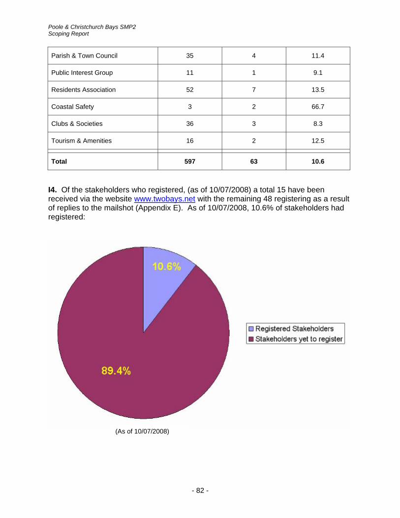
Poole & Christchurch Bays SMP2 Scoping Report
Parish & Town Council 35 4 11.4
Public Interest Group 11 1 9.1
Residents Association 52 7 13.5
Coastal Safety 3 2 66.7
Clubs & Societies 36 3 8.3
Tourism & Amenities 16 2 12.5
Total 597 63 10.6
I4. Of the stakeholders who registered, (as of 10/07/2008) a total 15 have been received via the website www.twobays.net with the remaining 48 registering as a result of replies to the mailshot (Appendix E). As of 10/07/2008, 10.6% of stakeholders had registered:
(As of 10/07/2008)
- 82 -

Poole & Christchurch Bays SMP2 Scoping Report
Appendix J: Database of data held by stakeholders
Report / Data Format Location
ABMS Hampshire Hard copy NFDC
Barton Cliffs Vegetation & Restoration Trials (NFDC 1999)
Hard copy NFDC
Barton-on-Sea cliff movement (NFDC 1995 to present)
Hard copy NFDC
Barton-on-Sea Cliff Stabilisation 2002 Electronic NFDC
Barton-on-Sea Piezometer Data (NFDC 1991 to Present)
Hard copy /electronic
NFDC
Barton-on-Sea Rain Gauge Data (NFDC 1999 to present|)
Hard copy /electronic
NFDC
Barton-on-Sea. Aerial photographs showing changes to the cliff top for the period 1950 – 1980
Hard copy Cliff House Hotel
Barton-on-Sea. Monitoring of Ground movement & Groundwater 1991 to 1997 (NFDC 1998)
Hard copy NFDC
Barton-on-Sea. The Coastal Landslides at Barton-on-Sea Hampshire UK (HP Rendel 2002)
Hard copy NFDC
Bournemouth Borough Council Leisure Services Seafront Strategy 2007 – 2011
Hard copy BBC / NFDC
Bournemouth Conurbation tourism usage figures / economic impact figures (£’s) at beach / beach usage numbers
Hard copy Bournemouth Seafront Office
CCO data (aerial ortho rectified photographs, topographic data bathymetry and LiDAR)
Electronic CCO
Christchurch Bay. The stability of the Shingle Beaches in the Eastern Half of Christchurch Bay (Ph.D. R. J. Nicholls 1985)
Hard copy NFDC
Christchurch Harbour & Waterways Management Plan
Hard copy /electronic
EA/LA’s
Christchurch Harbour. Annual ornithological reports dating back to 1956
Hard copy /electronic
Christchurch Harbour Ornithological Group
- 83 -

Poole & Christchurch Bays SMP2 Scoping Report
Dorset and East Devon Coast World Heritage Site (current)
Hard copy
Dredging. Application for Marine Aggregate Extraction Licence Area 451 St Catherine’s Environmental Statement
Hard copy NFDC
Durlston Bay Coastal Strategy Study (High-Point Rendel 2005)
Hard copy Purbeck DC / (summary on) www.purbeck.gov.uk
Environment Agency South West Region Report on Extreme Tide Levels Update March 2008 Second Draft
Hard copy /electronic
EA
Environmental Statement: Aggregate Production Licence Production West Channel (Area 465/1 & 465/2)
Hard copy NFDC
Event Report Coastal Flood Event 10th/11th March 2008 Wessex Area (Blandford Forum)
Hard copy /electronic
EA
Fishermen’s Jetty, Swanage. Hard copy /electronic
Purbeck DC
Future Coast (2002) Electronic Halcrow
Hampshire Coast – Historical Changes on the Hampshire Coast 1870 to 1965 (1987)
Hard copy NFDC
Hamworthy Park – photographs of flooding – Spring 2008
Hard copy /electronic
Lake Residents Association
Hengistbury Head – films & reports Electronic / see accompanying CD
Hengistbury Head Residents Association / NFDC
Hengistbury Head – observations & questions relating to Halcrow’s “Poole Bay & Harbour Strategy Study” July 2005
Electronic / see accompanying CD
Hengistbury Residents Association
Hengistbury Head – photographs of headland and low lying areas
Electronic / see accompanying CD
Hengistbury Head Residents Association / NFDC
Hengistbury Head – Sea breakthrough fact sheets 1,2 & 3 (Aug 05 to Nov 2007)
Electronic / see accompanying CD
Hengistbury Head Residents Association / NFDC
- 84 -

Poole & Christchurch Bays SMP2 Scoping Report
Hengistbury Head Coast Protection Study (Hydraulics Research 1986)
Hard copy NFDC
Hengistbury Head Consequences of Breaching Hard copy /electronic
EA
Hengistbury Head. Tackling Coastal Challenge. Dorset Rural Pathfinder Challenge 4: The breaching of Hengistbury Head
Electronic http://www.dorsetforyou.com/media/pdf/a/q/Dorset_Rural_Pathfinder_Project_Challenge_4.pdf
Holes Bay Flood Risk Pre Feasibility Report Hard copy /electronic
EA
Hurst Spit Stabilisation Scheme Dredging Area 406 Annual Reports
Hard copy NFDC
Marine Aggregate Evaluation of Shingles Bank Christchurch Bay (1992)
Hard copy NFDC
Middle Beach gabion sea defences condition assessment (Haskoning 2001 – 2008)
Hard copy National Trust
Milford-on-Sea Action Plan – Parish Vision 2020 (Sept 2007)
Hard copy Milford-on-Sea Residents Association / NFDC
Mudeford & Stanpit Flood Risk Pre Feasibility Report
Hard copy / CD EA
Mudeford & Stanpit Flood Risk Viability Report Hard copy /electronic
EA
Naish Beach Coast Protection Scheme Preliminary Studies (NFDC 1996)
Hard copy NFDC
National Coastal Erosion Risk Mapping (current) NCERM website
National Flood & Coastal Defence Database (current)
NFCDD website
National Trust. Plans of tenanted and franchised property/businesses. Details of NT infrastructure and Studland Bay amenities
Electronic National Trust
New Forest Coastal Archaeological Resource Hard copy NFDC
- 85 -

Poole & Christchurch Bays SMP2 Scoping Report
New Forest District Council Coastal Management Report (NFDC 1997)
Hard copy NFDC
New Forest District Council Coastal Management Report (NFDC 2003)
Hard copy NFDC
NFDC Report on analysis of cliff stability 1991 Hard copy / NFDC website
NFDC
Peveril Point Options Appraisal Report Electronic DCC
Poole & Christchurch Bays Research Project – Christchurch Bay (University of Southampton 1977)
Hard copy / electronic
NFDC
Poole & Christchurch Bays Research Project – Research on Beach Processes (University of Southampton 1976)
Hard copy NFDC
Poole & Christchurch Bays Research Project 1980
Hard copy NFDC
Poole & Christchurch Bays Research Project Sediment Sampling & Analysis (Southampton University 1986)
Hard copy NFDC
Poole & Christchurch Bays Research Project Sediment Sampling & Analysis Reports (Southampton University 1979 to 1988)
Hard copy NFDC
Poole Bay. Wave conditions at west end of Poole Bay commissioned by Branksome Park, Canford Cliffs & District Residents Association
- BPCCRA
Poole Harbour Approach Channel Deepening & Beneficial Use of Dredged Material. Environmental Statement
Hard copy /electronic
Hard copy NE
Electronic PHC
Poole Harbour Flood Model Review Hard copy EA
Poole Harbour Flood Risk Pre Feasibility Report Hard copy /electronic
EA
Poole Harbour SFRA Hard copy /electronic
PBC
Poole Harbour Strategy Tidal Flood Risk Mapping Final Summary Results Report July 2003
Hard copy EA
- 86 -

Poole & Christchurch Bays SMP2 Scoping Report
Poole Harbour, Christchurch, and Wareham Areas Benefiting from Defences Flood Risk Mapping. 2008
Hard copy /electronic
EA
Poole Harbour. The vegetation of Poole Harbour (Brian Edwards 2004)
Hard copy Natural England
Poole Sea Defences Feasibility Study 2008 Electronic EA
Purbeck District Council. Options Report Hard copy Purbeck DC
Purbeck District Strategic Flood Risk Assessment (Purbeck DC 2007)
Electronic Purbeck DC / www.purbeck.gov.uk
Response of Shingle Barrier Beaches to Extreme Hydrodynamic Conditions (Ph.D. A. P. Bradbury 1998)
Hard copy NFDC
Review of the Hampshire Coastline Volume I & II (HR Wallingford (1987)
Hard copy / www.scopac.org.uk
NFDC
SCOPAC Research Project. Coastal Sediment Transport Study Volume 4 Highcliffe Castle to Swanage (1991)
Hard copy / www.scopac.org.uk
NFDC
SCOPAC Research Project: Preparing for the Impacts of Climate Change (SCOPAC 2001)
Hard copy / www.scopac.org.uk
NFDC
SCOPAC Research Project: Sediment Inputs in the coastal system. Phase 3 (SCOPAC 1999)
Hard copy / www.scopac.org.uk
NFDC
SCOPAC Sediment Transport Study Hard copy NFDC
South Coast Tidal Flood Risk Mapping Summary Results Report March 2003 Final Report. SUPERSEDED by Tidal Flood Zones Compliance Main Stage. December 2007
Hard copy /electronic
EA
South Wessex Coastal Defences Strategic Review
Hard copy EA
South West - Report on Regional Extreme Tide Levels February 2003. SUPERSEDED by Environment Agency South West Region Report on Extreme Tide Levels Update
Hard copy EA
- 87 -

Poole & Christchurch Bays SMP2 Scoping Report
Southeast Strategic Regional Coastal Monitoring Programme Annual Reports & Wave Reports
Electronic http://www.channelcoast.org/
Strategic Monitoring of the Coastline Towards a Regional Approach (NFDC)
Hard copy NFDC
Students Dissertations / Various Hard copy NFDC
Studland Bay Management Plan - Managed realignment commissioned by National Trust (Halcrow 2006)
Hard copy National Trust
Studland. Middle Beach Studland - condition assessment of the gabion sea defences (Royal Haskoning 2001 - 2008)
Sturt Pond - A report on the Environmental Condition of Sturt Pond (NFDC 2001)
Hard copy NFDC
Swanage Bay Beach Management Study (Halcrow 2000)
Hard copy Purbeck DC
Swanage Beach Recharge Scheme Engineers Report and Beach Management Plan (Halcrow 2004)
Hard copy Purbeck DC
Swanage Beach Recharge Scheme Environmental statement (Halcrow 2004)
Hard copy Purbeck DC
Swanage Beach Recharge Scheme (Halcrow 2005)
Hard copy Purbeck DC
Swanage Coastal Flood Warning Procedures 2007 (Halcrow)
Hard copy EA
Tidal Flood Zones Compliance Main Stage. December 2007
Hard copy /electronic
EA
Wareham Meadows and Moors (15 Drawing Sheets) Land around Frome and Piddle
Electronic EA
Wareham Strategy Inception Report. October 2000
Electronic EA
Wareham Tide Banks Topographic Survey March 2004 and July 2005
Electronic EA
Wessex - rare reptile & amphibian locations Electronic The Herpetological Conservation Trust
- 88 -

Poole & Christchurch Bays SMP2 Scoping Report
Wessex Region - broad-spectrum risk assessment for all National Trust / Coastal Properties in the Wessex Region
Electronic / see accompanying CD
National Trust (Wessex)
- 89 -

Appendix K: List of stakeholders expressing an interest in joining the Key Stakeholder Group (for questionnaires returned to 10th July 2008)
Name Stakeholder Reference
Mus
eum
s
Indu
stry
&
Com
mer
ce
Ram
bler
s
Wat
er S
port
s
Clu
bs &
So
ciet
ies
Fish
ing
Land
Ow
ner
Tour
ism
Farm
ing
&
Agr
icul
ture
C
onse
rvat
ion/
En
viro
nmen
t Pa
rish/
Tow
n C
ounc
il R
esid
ents
A
ssoc
iatio
n Pu
blic
Inte
rest
G
roup
Oth
er
Cllr - CBC CCB14 Wessex Surf Club SOC36
East Dorset Friends of the Earth
CON21
New Forest Friends of the Earth
CON51
Milford Parish Council PTC19
Hengistbury Residents Association
RES25
Cllr - NFDC CNF06 Mudeford & District Fishermen
FIS02
Cllr - BOP CPB09
Mudeford Ferry TOU06

Poole & Christchurch Bays SMP2 Scoping Report
Name Stakeholder Reference
Mus
eum
s
Indu
stry
&
Com
mer
ce
Ram
bler
s
Wat
er S
port
s
Clu
bs &
So
ciet
ies
Fish
ing
Land
Ow
ner
Tour
ism
Farm
ing
&
Agr
icul
ture
C
onse
rvat
ion/
En
viro
nmen
t Pa
rish/
Tow
n C
ounc
il R
esid
ents
A
ssoc
iatio
n Pu
blic
Inte
rest
G
roup
Oth
er
Barker Mills Estate LAN02 Bournemouth Seafront TOU02 Mudford Sandbank News IND32 Cllr - EDDC CED23 Swanage Town Council PTC27
Cllr - DCC CDC16 Mudeford Sandbank Beach Huts
LAN18
Canford Cliffs RES08
Dorset Lakes RES18
Cllr – PDC CPD10
Stanpit & Mudeford RES44
Bournemouth Surf School IND14
Poole Yacht Club SOC29
- 91 -

Appendix L: Notes on Appropriate Assessment - the need and process
A search of the Internet has been conducted to identify what documents are currently available which provide guidance on the need for, and the processes involved, in preparing Appropriate Assessments (AAs) for land use plans. Their findings are detailed below. It is now established that SMPs and CFMPs, because of their potential to influence the development of land, will also be subject to AA.
AA is still in its early stages and guidance is still forthcoming, particularly with respect to SMPs and CFMPs. The two principal documents most frequently quoted that have provided the best source of guidance to date are; 'Planning for the Protection of European Sites: Appropriate Assessment' (DCLG, 2006) and 'The Assessment of Regional Spatial Strategies under the Provisions of the Habitats Regulations - Draft Guidance' (English Nature, 2006). However, a more recent paper, prepared in partnership by Scott Wilson, Levett-Therivel Sustainability Consultants, Treweek Environmental Consultants and Land Use Consultants, entitled 'Appropriate Assessment of Plans' (September 2006), provides a very clear and concise resume of the legislation driving AA and the processes behind preparing such a plan. The paper aims to provide advice for English authorities on the application of AA plans (including land use plans), and draws on existing guidance and information published by the European Commission, the former ODPM (now the Department for Communities and Local Government, DCLG) and Natural England. It has also been informed by existing case law in relation to the Habitats Directive as well as advice from experts in the fields of ecology, ecological impact assessment, strategic environmental assessment and sustainability appraisal, and has been widely consulted on.
The legislation driving AA is covered in most of the guidance documentation and will not be reiterated here other than to quote Article 6(3) of the Habitats Directive which establishes the requirement for Appropriate Assessment:
Any plan or project not directly connected with or necessary to the management of the site but likely to have a significant effect thereon, either individually or in combination with other plans or projects, shall be subject to appropriate assessment of its implications for the site in view of the site's conservation objectives. In the light of the conclusions of the assessment of the implications for the site and subject to the provisions of paragraph 4, the competent national authorities shall agree to the plan or project only after having ascertained that it will not adversely affect the integrity of the site concerned and, if appropriate, after having obtained the opinion of the general public. Article 6(3)
The following is a summary of the guidance contained in the paper.
The AA plan is divided into 4 distinct key stages:
Stage 1: Screening; Stage 2: Appropriate Assessment; Stage 3: Assessment of alternative solutions; Stage 4: Assessment where no alternative solutions remain and where adverse impacts
remain.
The paper focuses primarily on Stages 1 and 2 (Screening and AA), which relate to Article 6(3) of the Habitats Directive, with the aim of avoiding the need for the more detailed,

Poole & Christchurch Bays SMP2 Scoping Report
complex and expensive alternatives and 'imperative reasons of overriding public interest' (IROPI) stages. Because of the legal weight the Habitats Directive carries, it is recommend that AA should begin early in the plan-making process and influence the development of the plan as it emerges. The aim should be to influence the development and appraisal of plan options, to help choose options that do not have an adverse effect on site integrity. Only undertaking AA on a fully drafted plan will mean that there may be limited room for manoeuvre and this is not advised.
Stage 1: Screening
The screening stage identifies whether a plan - either alone or in combination with other plans or projects - is likely to have a significant impact on a European site. European Commission (2001) guidance recommends that this stage should comprise:
1. determining whether the plan is directly connected with or necessary to the management of the site - if it is, then no further assessment is necessary;
2. describing the plan and other plans and projects that, 'in combination', have the potential to have significant effects on a European site;
3. identifying the potential effects on the European site; and
4. assessing the significance of any effects on the European site. Stage 1 Screening thus provides a first round analysis which determines whether a plan can be clearly said not to require AA (if not, then the assumption is that it will). This stage also involves compiling a 'long list' of European sites for later analysis which may or may not ultimately be impacted upon by the plan.
AA requires ecological expertise in order that sound judgments on impacts on site integrity can be made and it is recommended that Natural England, the conservation body under the Habitats Regulations, should be contacted early in the AA process, and kept involved throughout. Natural England does not make the ultimate AA decision, but if they are satisfied with the AA, then others are likely to be too.
Stage 2: Appropriate Assessment
The AA stage considers the impact on the integrity of the European site(s) of the plan, alone or in combination with other projects or plans, with respect to the site's structure and function and its conservation objectives. Where there are adverse impacts, this stage also involves proposing and assessing potential mitigation measures to alleviate the impacts. This stage consists of six substages or tasks:
1. Stage 2A - analyse the site(s) and the reasons for its designation, and the underlying trends affecting it.
2. Stage 2B - analyse the plan, including its key components and how it would be implemented in practice.
3. Stage 2C - analyse other plans and projects that could contribute to 'in combination' effects.
4. Stage 2D - analyse how the plan -in combination with other plans and projects and the
- 93 -
Poole & Christchurch Bays SMP2 Scoping Report
site will 'interact' come plan implementation, i.e. Appropriate Assessment.
5. Stage 2E - where applicable, propose and assess mitigation measures for addressing adverse effects.
6. Stage 2F - prepare an Appropriate Assessment Report for consultation with key stakeholders, including Natural England.
Stage 2D can be seen as a further iteration of Stage 1 - screening - only this time armed with more baseline information about the sites in question, the nature of the plan and the plan's potential impacts.
In Stage 2, some (or all) sites in the 'long list' of sites may be removed from the list, as more information on the plan's potential effects on the site(s) becomes available and it is possible to demonstrate that no adverse impact would occur.
It is again strongly recommend that plan authors aim to write their plan so that impacts on European sites are avoided and that a site-based, bottom up approach to AA is adopted.
The paper also makes reference to the fact that there are clear parallels between AA, Strategic Environmental Assessment (SEA) and Sustainability Appraisal (SA) since all three are processes for assessing and minimizing the environmental and sustainability impacts of plans. Forthcoming guidance from the Government on applying AA to plans will recommend undertaking AA and SEA/SA processes in parallel, with the aim of encouraging 'joined up thinking' and avoiding duplication of effort.
- 94 -

Poole & Christchurch Bays SMP2 Scoping Report
Appendix M: Map of SMP area
- 95 -