Embed Size (px)
Citation preview
The above provides the local details in respect of the SMP-wide policy presented in the preceding sections of this Plan document. These details must be read in the context of the wider-scales issues and policy implications, as reported therein.
Severn Estuary SMP2 Review – Final Report
1
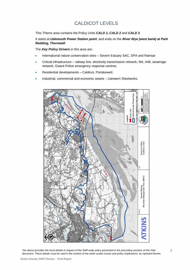
CALDICOT LEVELS
This Theme area contains the Policy Units CALD 1, CALD 2 and CALD 3.
It starts at Uskmouth Power Station point, and ends on the River Wye (west bank) at Park Redding, Thornwell.
The Key Policy Drivers in this area are:
• International nature conservation sites – Severn Estuary SAC, SPA and Ramsar
• Critical infrastructure – railway line, electricity transmission network, M4, A48, sewerage network, Gwent Police emergency response centres;
• Residential developments – Caldicot, Portskewett;
• Industrial, commercial and economic assets – Llanwern Steelworks.

The above provides the local details in respect of the SMP-wide policy presented in the preceding sections of this Plan document. These details must be read in the context of the wider-scales issues and policy implications, as reported therein.
Severn Estuary SMP2 Review – Final Report
2
The above provides the local details in respect of the SMP-wide policy presented in the preceding sections of this Plan document. These details must be read in the context of the wider-scales issues and policy implications, as reported therein.
Severn Estuary SMP2 Review – Final Report
3
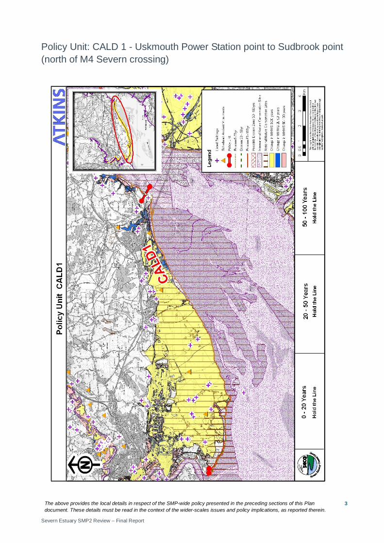
Policy Unit: CALD 1 - Uskmouth Power Station point to Sudbrook point (north of M4 Severn crossing)

The above provides the local details in respect of the SMP-wide policy presented in the preceding sections of this Plan document. These details must be read in the context of the wider-scales issues and policy implications, as reported therein.
Severn Estuary SMP2 Review – Final Report
4
Preferred Policies to Implement the Plan:
Epoch Preferred Policy Comments
0 to 20 years (2025)
HTL
The short term policy for this unit is Hold The Line.
The existing defences will come to the end of their serviceable life in this epoch. HTL recommends that defences are replaced. The position, size and materials of new defences should be considered in more detail by the SEFRMS. Opportunities to create habitat and help manage the impacts of sea level rise through MR should be investigated when the position of any new defences is chosen. HTL will manage the risk of impacts from flooding to residential, commercial and industrial assets and infrastructure (road, rail, electricity) in this and linked Policy Units (NEW 4, NEW 5). Investigations of future potential for MR should start in this epoch. All stakeholders should be involved. Future MR will help manage impacts from sea level rise and create new habitat.
HTL does not guarantee funding to build or maintain current or future defences or to counter sea level rise.
20 to 50 years (2055)
HTL
The medium term policy for this unit is Hold The Line.
Reconstructed defences should be maintained. HTL will manage the risk of impacts from flooding residential, commercial and industrial assets and infrastructure (road, rail, electricity) in this and linked Policy Units (NEW 4, NEW 5).
HTL does not guarantee funding to build or maintain current or future defences or to counter sea level rise.
50 to 100 years (2105)
HTL
The long term policy for this unit is Hold The Line.
Reconstructed defences should be maintained. HTL will manage the risk of impacts from flooding residential, commercial and industrial assets and infrastructure (road, rail, electricity) in this and linked Policy Units (NEW 4, NEW 5). The potential for MR should be investigated to create a long term sustainable defence.
HTL does not guarantee funding to build or maintain current or future defences or to counter sea level rise.
Economics
Policy Unit
Existing SMP1 Policy
Time Period (epoch) SMP2 Assessment
0-20
20-50
50-100
Preferred Plan Present Value Damages
Preferred Plan Present Value Defence Costs
CALD 1 HTL HTL HTL HTL £1,135m (NEW4-5, CALD1 total)
£37m (NEW4-5, CALD1 total)
The preferred policy is economically viable for the linked Policy Units of NEW 4, NEW 5, and CALD 1. The costs and damages of the preferred policy in the table above relate to actions taken in all linked policy units.

The above provides the local details in respect of the SMP-wide policy presented in the preceding sections of this Plan document. These details must be read in the context of the wider-scales issues and policy implications, as reported therein.
Severn Estuary SMP2 Review – Final Report
5
Predicted Implication of the Preferred Plan for the CALD 1 Policy Unit
Time Period
Management Activities
Property, Land Use and Human Health
Nature Conservation – including Earth Heritage, Geology and Biodiversity
Landscape Character and Visual Amenity Historic Environment Amenity and
Recreational Use
0 – 20 years
The existing defences are likely to be replaced in this epoch. Following replacement a monitoring and maintenance programme should be established. Studies to help inform the potential for MR should be undertaken.
Defences will manage the risk of impacts from flooding to existing properties and land use of this and adjacent units will be protected from increased risk of flooding and erosion. Realignment of defences could lead to a loss of property / land but reduce the risk of impacts from flooding to areas behind the new defences. Losses will depend on the location of new defences.
Coastal squeeze may occur resulting in loss of intertidal habitats and affect Severn N2K. The Gwent Levels- Nash and Goldcliff, Gwent Levels- Whitson, Gwent Levels -Redwick, Gewnt Levels- Llandevenny, Gwent Levels- Magor and Undy SSSIs terrestrial habitats will be protected. Realignment of defences could lead to a loss of terrestrial habitat but the creation of intertidal habitat in front of new defences. The integrity of the Severn Estuary SAC, SPA and Ramsar site should be maintained. Works should take account of possible environmental impacts and the need for an EIA.
Defences are likely to come to the end of their serviceable life. Increased height of defences or change in defence construction materials will affect local landscape - increasing presence in the landscape and disrupting views. Realignment of defences will alter the landscape, but may be less visually intrusive than higher defences in their current location.
Defences will manage the risk of flooding on protect historic environment assets and protect the Historic Landscape designation. Realignment of defences could lead to the loss of historic environment features and alter the historic landscape.
The defences will prevent increase in present flood risk to amenity and recreational assets. Realignment of defences could lead to the loss of recreational assets. PRoW / coastal path may need to be re-routed.

The above provides the local details in respect of the SMP-wide policy presented in the preceding sections of this Plan document. These details must be read in the context of the wider-scales issues and policy implications, as reported therein.
Severn Estuary SMP2 Review – Final Report
6
Time Period
Management Activities
Property, Land Use and Human Health
Nature Conservation – including Earth Heritage, Geology and Biodiversity
Landscape Character and Visual Amenity Historic Environment Amenity and
Recreational Use
20 – 50 years
The monitoring and maintenance programme should continue. As and when defences need to be replaced, opportunities for MR should be considered.
Defences will manage the risk of impacts from flooding to existing properties and land use of this and adjacent units will be protected from increased risk of flooding and erosion. Realignment of defences could lead to a loss of property / land but reduce the risk of impacts from flooding to areas behind the new defences. Losses will depend on the location of new defences.
Coastal squeeze may occur resulting in loss of intertidal habitats and affect Severn N2K. The Gwent Levels SSSIs (as above),terrestrial habitats, will be protected. Realignment of defences could lead to a loss of terrestrial habitat but the creation of intertidal habitat in front of new defences. The integrity of the Severn Estuary SAC, SPA and Ramsar site should be maintained. Works should take account of possible environmental impacts and the need for an EIA.
Increased height of defences or change in defence construction materials could affect local landscape - increasing presence in the landscape and disrupting views. Realignment of defences will alter the landscape, but may be less visually intrusive than higher defences in their current location.
Defences will manage the risk of flooding on protect historic environment assets and protect the Historic Landscape designation. Realignment of defences could lead to the loss of historic environment features and alter the historic landscape.
The defences will prevent increase in present flood risk to amenity and recreational assets. Realignment of defences could lead to the loss of recreational assets. PRoW / coastal path may need to be re-routed.
50 – 100 years
The monitoring and maintenance programme should continue. MR should be considered to create a long term sustainable defence.
Defences will manage the risk of impacts from flooding to existing properties and land use of this and adjacent units will be protected from increased risk of flooding and erosion. Realignment of defences could lead to a loss of property / land but reduce the risk of impacts from flooding to areas behind the new defences. Losses will depend on the location of new defences.
Coastal squeeze may occur resulting in loss of intertidal habitats and affect Severn N2K. The Gwent Levels SSSIs (as above), terrestrial habitats, will be protected. Realignment of defences could lead to a loss of terrestrial habitat but the creation of intertidal habitat in front of new defences. The integrity of the Severn Estuary SAC, SPA and Ramsar site should be maintained. Works should take account of possible environmental impacts and the need for an EIA.
Increased height of defences or change in defence construction materials could affect local landscape - increasing presence in the landscape and disrupting views. Realignment of defences will alter the landscape, but may be less visually intrusive than higher defences in their current location.
Defences will manage the risk of flooding on protect historic environment assets and protect the Historic Landscape designation. Realignment of defences could lead to the loss of historic environment features and alter the historic landscape.
The defences will prevent increase in present flood risk to amenity and recreational assets. Realignment of defences could lead to the loss of recreational assets. PRoW / coastal path may need to be re-routed.
The above provides the local details in respect of the SMP-wide policy presented in the preceding sections of this Plan document. These details must be read in the context of the wider-scales issues and policy implications, as reported therein.
Severn Estuary SMP2 Review – Final Report
7
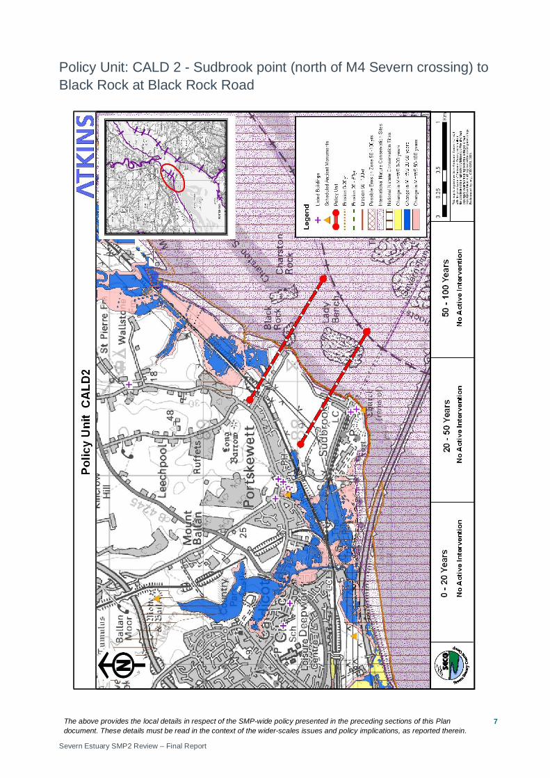
Policy Unit: CALD 2 - Sudbrook point (north of M4 Severn crossing) to Black Rock at Black Rock Road
The above provides the local details in respect of the SMP-wide policy presented in the preceding sections of this Plan document. These details must be read in the context of the wider-scales issues and policy implications, as reported therein.
Severn Estuary SMP2 Review – Final Report
8
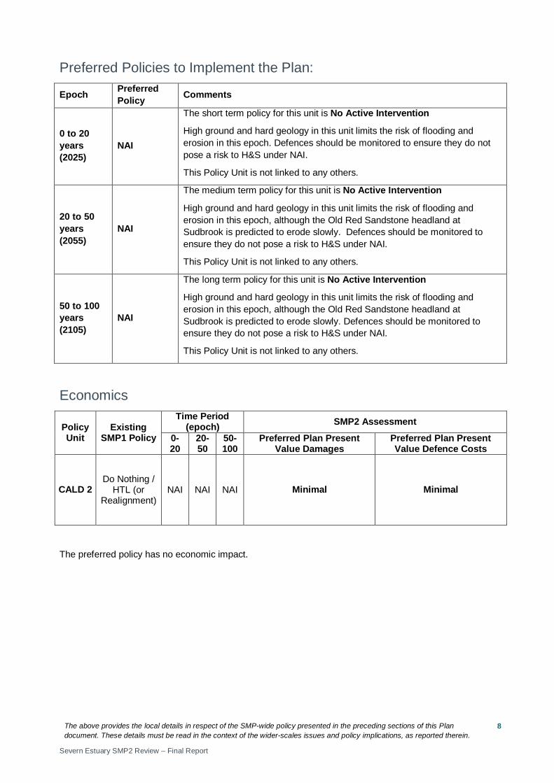
Preferred Policies to Implement the Plan:
Epoch Preferred Policy Comments
0 to 20 years (2025)
NAI
The short term policy for this unit is No Active Intervention
High ground and hard geology in this unit limits the risk of flooding and erosion in this epoch. Defences should be monitored to ensure they do not pose a risk to H&S under NAI.
This Policy Unit is not linked to any others.
20 to 50 years (2055)
NAI
The medium term policy for this unit is No Active Intervention
High ground and hard geology in this unit limits the risk of flooding and erosion in this epoch, although the Old Red Sandstone headland at Sudbrook is predicted to erode slowly. Defences should be monitored to ensure they do not pose a risk to H&S under NAI.
This Policy Unit is not linked to any others.
50 to 100 years (2105)
NAI
The long term policy for this unit is No Active Intervention
High ground and hard geology in this unit limits the risk of flooding and erosion in this epoch, although the Old Red Sandstone headland at Sudbrook is predicted to erode slowly. Defences should be monitored to ensure they do not pose a risk to H&S under NAI.
This Policy Unit is not linked to any others.
Economics
Policy Unit
Existing SMP1 Policy
Time Period (epoch) SMP2 Assessment
0-20
20-50
50-100
Preferred Plan Present Value Damages
Preferred Plan Present Value Defence Costs
CALD 2 Do Nothing /
HTL (or Realignment)
NAI NAI NAI Minimal Minimal
The preferred policy has no economic impact.
The above provides the local details in respect of the SMP-wide policy presented in the preceding sections of this Plan document. These details must be read in the context of the wider-scales issues and policy implications, as reported therein.
Severn Estuary SMP2 Review – Final Report
9
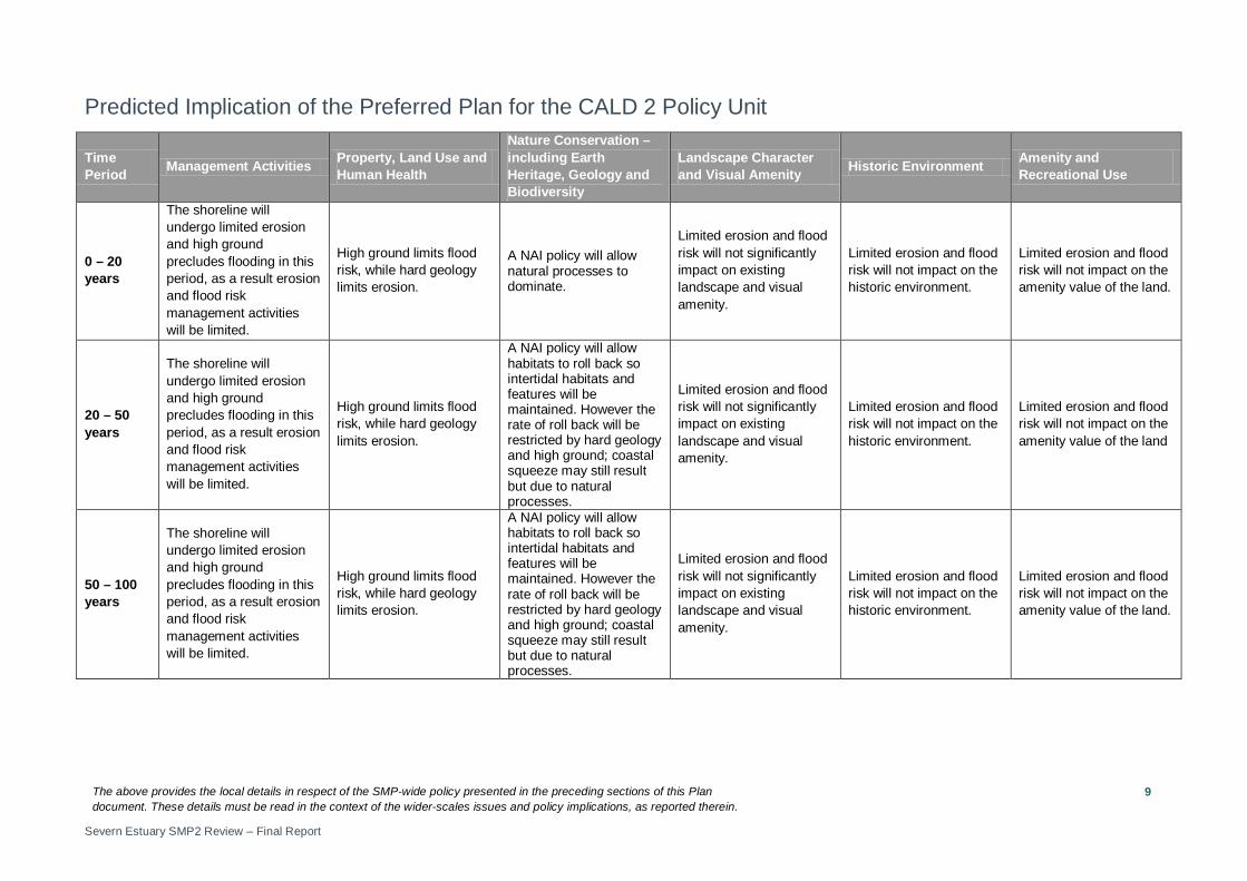
Predicted Implication of the Preferred Plan for the CALD 2 Policy Unit
Time Period Management Activities Property, Land Use and
Human Health
Nature Conservation – including Earth Heritage, Geology and Biodiversity
Landscape Character and Visual Amenity Historic Environment Amenity and
Recreational Use
0 – 20 years
The shoreline will undergo limited erosion and high ground precludes flooding in this period, as a result erosion and flood risk management activities will be limited.
High ground limits flood risk, while hard geology limits erosion.
A NAI policy will allow natural processes to dominate.
Limited erosion and flood risk will not significantly impact on existing landscape and visual amenity.
Limited erosion and flood risk will not impact on the historic environment.
Limited erosion and flood risk will not impact on the amenity value of the land.
20 – 50 years
The shoreline will undergo limited erosion and high ground precludes flooding in this period, as a result erosion and flood risk management activities will be limited.
High ground limits flood risk, while hard geology limits erosion.
A NAI policy will allow habitats to roll back so intertidal habitats and features will be maintained. However the rate of roll back will be restricted by hard geology and high ground; coastal squeeze may still result but due to natural processes.
Limited erosion and flood risk will not significantly impact on existing landscape and visual amenity.
Limited erosion and flood risk will not impact on the historic environment.
Limited erosion and flood risk will not impact on the amenity value of the land
50 – 100 years
The shoreline will undergo limited erosion and high ground precludes flooding in this period, as a result erosion and flood risk management activities will be limited.
High ground limits flood risk, while hard geology limits erosion.
A NAI policy will allow habitats to roll back so intertidal habitats and features will be maintained. However the rate of roll back will be restricted by hard geology and high ground; coastal squeeze may still result but due to natural processes.
Limited erosion and flood risk will not significantly impact on existing landscape and visual amenity.
Limited erosion and flood risk will not impact on the historic environment.
Limited erosion and flood risk will not impact on the amenity value of the land.

The above provides the local details in respect of the SMP-wide policy presented in the preceding sections of this Plan document. These details must be read in the context of the wider-scales issues and policy implications, as reported therein.
Severn Estuary SMP2 Review – Final Report
10
Policy Unit: CALD 3 - Black Rock at Black Rock Road to River Wye (West bank) at Park Redding, Thornwell
The above provides the local details in respect of the SMP-wide policy presented in the preceding sections of this Plan document. These details must be read in the context of the wider-scales issues and policy implications, as reported therein.
Severn Estuary SMP2 Review – Final Report
11
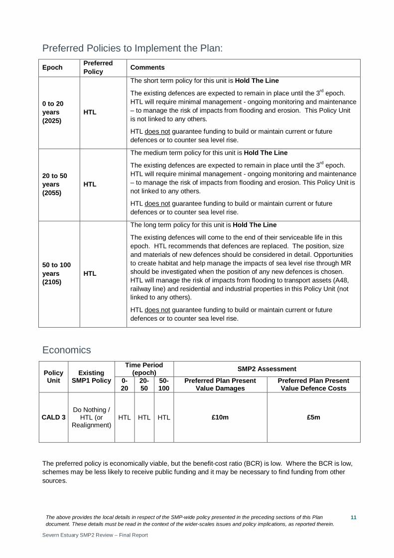
Preferred Policies to Implement the Plan:
Epoch Preferred Policy Comments
0 to 20 years (2025)
HTL
The short term policy for this unit is Hold The Line
The existing defences are expected to remain in place until the 3rd epoch. HTL will require minimal management - ongoing monitoring and maintenance – to manage the risk of impacts from flooding and erosion. This Policy Unit is not linked to any others.
HTL does not guarantee funding to build or maintain current or future defences or to counter sea level rise.
20 to 50 years (2055)
HTL
The medium term policy for this unit is Hold The Line
The existing defences are expected to remain in place until the 3rd epoch. HTL will require minimal management - ongoing monitoring and maintenance – to manage the risk of impacts from flooding and erosion. This Policy Unit is not linked to any others.
HTL does not guarantee funding to build or maintain current or future defences or to counter sea level rise.
50 to 100 years (2105)
HTL
The long term policy for this unit is Hold The Line
The existing defences will come to the end of their serviceable life in this epoch. HTL recommends that defences are replaced. The position, size and materials of new defences should be considered in detail. Opportunities to create habitat and help manage the impacts of sea level rise through MR should be investigated when the position of any new defences is chosen. HTL will manage the risk of impacts from flooding to transport assets (A48, railway line) and residential and industrial properties in this Policy Unit (not linked to any others).
HTL does not guarantee funding to build or maintain current or future defences or to counter sea level rise.
Economics
Policy Unit
Existing SMP1 Policy
Time Period (epoch) SMP2 Assessment
0-20
20-50
50-100
Preferred Plan Present Value Damages
Preferred Plan Present Value Defence Costs
CALD 3 Do Nothing /
HTL (or Realignment)
HTL HTL HTL £10m £5m
The preferred policy is economically viable, but the benefit-cost ratio (BCR) is low. Where the BCR is low, schemes may be less likely to receive public funding and it may be necessary to find funding from other sources.
The above provides the local details in respect of the SMP-wide policy presented in the preceding sections of this Plan document. These details must be read in the context of the wider-scales issues and policy implications, as reported therein.
Severn Estuary SMP2 Review – Final Report
12
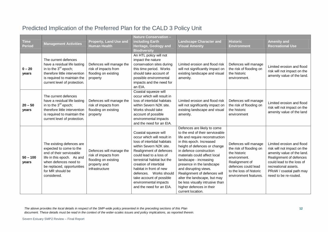
Predicted Implication of the Preferred Plan for the CALD 3 Policy Unit
Time Period Management Activities Property, Land Use and
Human Health
Nature Conservation – including Earth Heritage, Geology and Biodiversity
Landscape Character and Visual Amenity
Historic Environment
Amenity and Recreational Use
0 – 20 years
The current defences have a residual life lasting in to the 3rd epoch; therefore little intervention is required to maintain the current level of protection.
Defences will manage the risk of impacts from flooding on existing property
An HTL policy will not impact the nature conservation sites during this time period. Works should take account of possible environmental impacts and the need for an EIA.
Limited erosion and flood risk will not significantly impact on existing landscape and visual amenity.
Defences will manage the risk of flooding on the historic environment.
Limited erosion and flood risk will not impact on the amenity value of the land.
20 – 50 years
The current defences have a residual life lasting in to the 3rd epoch; therefore little intervention is required to maintain the current level of protection.
Defences will manage the risk of impacts from flooding on existing property
Coastal squeeze will occur which will result in loss of intertidal habitats within Severn N2K site. Works should take account of possible environmental impacts and the need for an EIA.
Limited erosion and flood risk will not significantly impact on existing landscape and visual amenity.
Defences will manage the risk of flooding on the historic environment
Limited erosion and flood risk will not impact on the amenity value of the land
50 – 100 years
The existing defences are expected to come to the end of their serviceable life in this epoch. As and when defences need to be replaced, opportunities for MR should be considered.
Defences will manage the risk of impacts from flooding on existing property and infrastructure
Coastal squeeze will occur which will result in loss of intertidal habitats within Severn N2K site. Realignment of defences could lead to a loss of terrestrial habitat but the creation of intertidal habitat in front of new defences. Works should take account of possible environmental impacts and the need for an EIA.
Defences are likely to come to the end of their serviceable life and require reconstruction in this epoch. Increased height of defences or change in defence construction materials could affect local landscape - increasing presence in the landscape and disrupting views. Realignment of defences will alter the landscape, but may be less visually intrusive than higher defences in their current location.
Defences will manage the risk of flooding on the historic environment. Realignment of defences could lead to the loss of historic environment features.
Limited erosion and flood risk will not impact on the amenity value of the land. Realignment of defences could lead to the loss of recreational assets. PRoW / coastal path may need to be re-routed.