Embed Size (px)
Citation preview
5.0
Waterfront Trail - On-road / Sur la route
Waterfront Trail - Proposed / Proposée
Waterfront Trail - Off-road / Hors route
Alerts / Alertes
Distance / Distance (km)
Hospital / Hôpital
Attraction / Attraction
Provincial Highway / Route provinciale
Regional Road / Route régionale
Beach / Plage
Campground / Camping
Railway Crossing / Passage à niveau
Roofed Accommodation / Hébergement avec toiture
Commercial Area / Zone commerciale
Wifi / Wifi
Restaurants / Restaurants
Liquor Control Board of Ontario / Régie des alcools de l'Ontario
Information / Renseignements
Viewpoint / Vue panoramique
Marina / Marina
Parking / Stationnement
Town Hall / Hôtel de ville
Washrooms / Washrooms
P
?
Hiking Trails / Sentiers de randonnées
Mountain Bike Trails / Sentiers de vélo de montagne
Park, Natural Area / Parc, Espace naturel
Provincial Park / Parc provincial de l’Ontario
Great Lakes Waterfront Trail / Sentier riverain des Grands Lacs
Trans Canada Trail / Sentier Transcanadien
Conservation Area / Zone de protection de la nature
Other Trails - Routes /D'autres pistes - Routes
Waterfront Trail - Gravel road / Route en gravier
A$
LCBO
Legend / Légende
83
21
Junction Marker / Marqueur de jonction
*
*Contains information licensed under the Open Government Licence – Canada*Contains information licensed under the Open Government Licence – Ontario
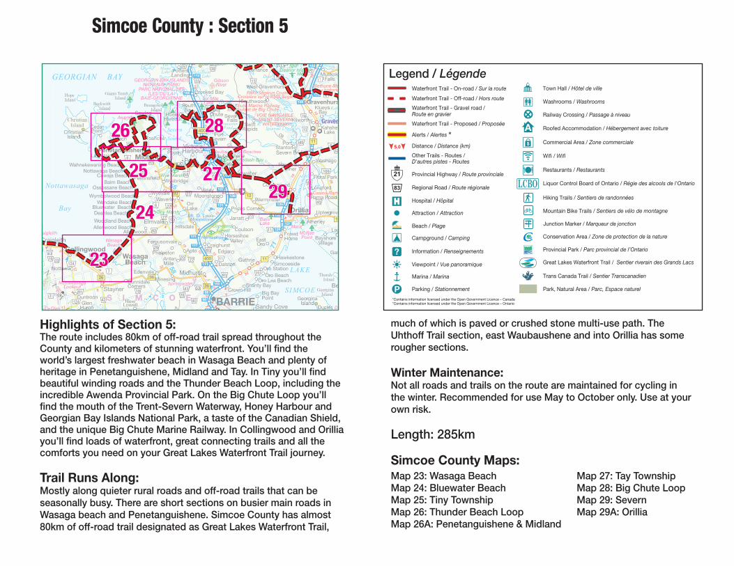
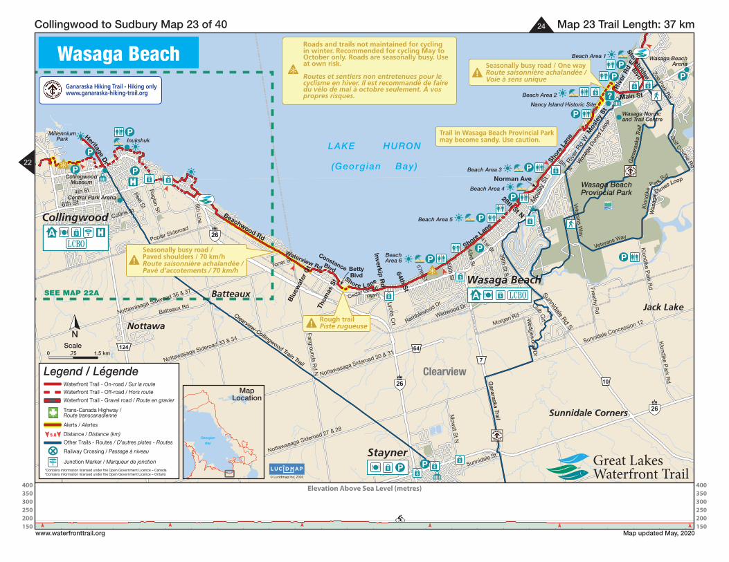
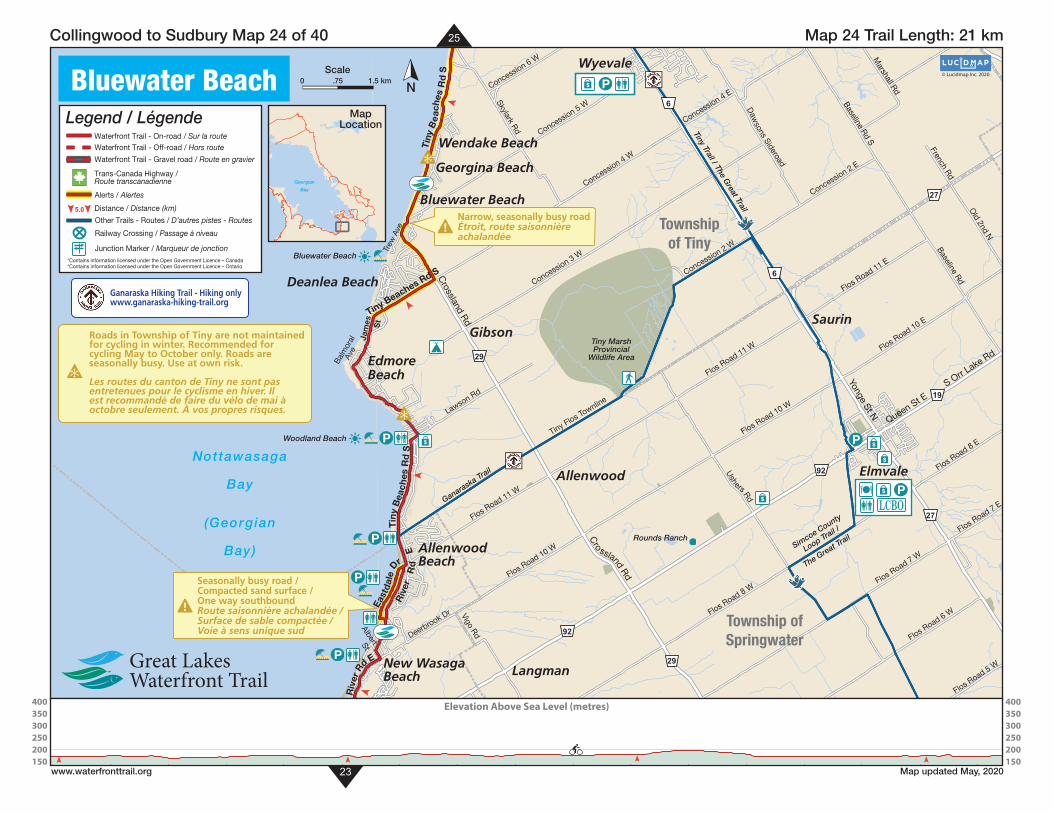
Highlights of Section 5:The route includes 80km of off-road trail spread throughout the County and kilometers of stunning waterfront. You’ll fi nd the world’s largest freshwater beach in Wasaga Beach and plenty of heritage in Penetanguishene, Midland and Tay. In Tiny you’ll fi nd beautiful winding roads and the Thunder Beach Loop, including the incredible Awenda Provincial Park. On the Big Chute Loop you’ll fi nd the mouth of the Trent-Severn Waterway, Honey Harbour and Georgian Bay Islands National Park, a taste of the Canadian Shield, and the unique Big Chute Marine Railway. In Collingwood and Orillia you’ll fi nd loads of waterfront, great connecting trails and all the comforts you need on your Great Lakes Waterfront Trail journey.
Trail Runs Along:Mostly along quieter rural roads and off-road trails that can be seasonally busy. There are short sections on busier main roads in Wasaga beach and Penetanguishene. Simcoe County has almost 80km of off-road trail designated as Great Lakes Waterfront Trail,
Simcoe County : Section 5
137
131
141
136
121
117
111
98
96
94 S
147
149
153156
162
102
RR
168
174
169
175
182
135
133
131
129
38
50
2671
15
10
6
55
7
19
15
54
11
10
19
58
25
7
5
94
2
32
8
6
10
12
5
11
26
22
19
19
12
9
6
16
CP
CN
CN
CP
S I M C O E
RMS Segwun CruiseCroisière sur le RMS Segwun
Big Chute Marine RailwayBer roulant de Big Chute
Bethune MeLieu historiq
VOIE NAVIGABLETRENT-SEVERN
WATERWAY
Casino Rama
Mt. St. Louis-Moonstone
Horseshoeraigleith
vil’s Glen
Wasaga Beach
Awenda
Bass Lake
Springwater
DuP
MaraMcRae Point
Waubaushene Beaches
GEORGIAN BAY ISLANDSNATIONAL PARK/
PARC NATIONAL DESÎLES-DE-LA-
BAIE-GEORGIENNE
Gibson River
Six Mile Lake
Nottawasaga Lookout
Tiny Marsh
Copeland Forest
Wye Marsh
RNFEleanor Island NWA
Matchedash Bay
HopeIsland
Giants Tomb Island
Beckwith Island
Beausoleil Island
ChristianIsland
NI
AG
Thorah Island
Georgina Island546 m
tawasaga
Bay OrrLake
LAKE
SIMCOELa
ke C
ouch
ichin
g
SevernSound
GoHomeLakeGo H
Gibson Lake Deer
Lake
R.
Severn
North River
Sparrow L.Gloucester
Pond
Stu
rgeo
n
R
.
Chr
istia
n C
hannel
Kahs La
B
H
South
Nottawasaga
Creek
Coate
26 26
11400
1293
12
400
11
26
12
921
32
42
9
7
1031 28
29
29
22
6
48
5
6
23
58
19
23
19
11
22
11
20
45
44
6
6
49
13
19
3238
33 1713
34
52
17
17
25
26
40
43 53
16
93
93
27
27
91
92
169
124
124
93
169
27
19
1
ChristianIsland
Lafontaine
Wahnekewaning BeachNottawaga Beach
Cawaja BeachBalm Beach
Ossossane Beach
Wymbolwood BeachWendake Beach
Bluewater BeachDeanlea Beach
Woodland Beach
WasagaBeach
CollingwoodCraigleith
Nottawa
Stayner
Elmvale
GlenHuron
DuntroonNew
Lowell
Toanche
Paradise Point
Cedar Point
ThunderBeach
Perkinsfield
MidlandPenetanguishene
PortMcNicoll
WyevaleWaverley
OrrLake
Wyebridge
VaseyMoonstone
Jarratt
SawlogBay
VictoriaHarbour
Hillsdale
Fergusonvale
Phelpston Apto
Midhurst
AntenMills
Edenvale
MinesingSunnidaleCorners
HoneyHarbour
SouthBay
BARRIE
Orillia
Guthrie
Sandy Cove
Big BayPoint
BeShanty Bay
DuclosP i t
Oro Station
Crown Hill
HawkestoneGam
LagC
BayshoreVillage
ForestHome
Atherley
Uptergrov
EdgarCraighurst
CoulsonHorseshoe
Valley
Dalston
Prices Corner
Coldwater
WarminsterArdtrea
CumberlandBeach
Hawkins Corner
PortStanton
SevernFalls
SwiftRapids
PortSevern
Waubaushene
FessertonSturgeon
BayFloral Park
Longford
Washago
S
Severn Bridge
Klueys Bay
Kilworthy
KahsheLake
Big Chute
Crooked Bay
Muskoka Falls
Gravenhurs
Torrance
West Gravenhurst
Southwood
PointSahanatienPottersLanding
Rama Road
Allenwood BeachAllenwood
Simcoeside
Oro BeachOro Lea Beach
EastOro
BowersBeach
GeorginaIsland
Graven
137
131
141
136
121
117
111
98
96
94 S
147
149
153156
162
102
RR
168
17
169
175
182
135
133
131
129
38
50550
26711
15
10
6
5555555555
7
19
15
54
11
10
19
58
25
77
5
99994
22
32
8
6
101010
12
55
111
26
222
19
19
11212121221212
9
66
1666
CP
CN
CNNCNNCN
CP
EEEM C OCCMMMMI MMI MI MS MM EI M
RMS Segwun CruiseMS SMS Segwuwun C ewuwun C eegRMS Segwun CruisegSegwunnwunwunCroisière sur le RMS SegRMS SRMS Ssu e R S See S SeC r l RMS SegRMRM SSSSSSSSCC uuuuusière sur le RMS SegwunnnnnnuuuMMMRRRroisière sur le RMS SegwRisière sur le RMS SegwMMMoisière sur le RMS Sege ee RMS Seeoisière sur le RMS Segisière sur le RMS Seeeère sur le RMS Segwwwsière sur le RMMMRRsière sur le RMS Segwwroisière sur le RCC SSSiCroisière sur le RMS Segwun
gggg
yyyBig Chute Marine Railwagg Cg Cg Cg C lwaBig lwaig h ai yyygggggg waywaywCCC ailwaaarine Railwaaute Marine Railllne Rainig Chute MariiiBBBBBB wwwwwg Chute Mggg e MarineChute Marine RailwaCCg ChutgBigBBiiBiBiBBBBBB e Marine RailwaywMarine Railwaae MarineB arine RailwawwBig Chute Marine Ri Ch t M i R iBig Chute Marine RailwaygBer roulant de Big Chuteerr r e r rouro tu eer r teer rro gulant de Big Chutttt de Big Chuhroulant de BrrrrrrrBer roulant de Biooooer roulant de Big eeo eee eeeoulant deoer roulant de Big ChCh tttBer roulant de Big Chuteeeee ant de Big Chuteeer roulant deeBer roulant de B teeteBer roulant de Br CBer roulant de Big Chute
yyyyggggggggg
eMeMeMMhune MeBethuneut MMBethunBB MMMeeeeeethunee MeeethBBBB eBethB MMMe MeeeBBBBBethune MeiqiqqLieu historiqto qLieu qLie qqqu ttsieu historiiiLLLL ooeu his oe qqeu histottLiLLLLL eu hisseieu historiLieu historiq
NNVOIE NNVOIE NNOVOIE NNAAAAAAAAAAAAANNNN EEEBLBLBAAIGIGIVVIVIVIGGG EEEBBBBAAAVIIIVVVV LLLAAAGAGAGAGAAABABBBLELELVVV ABBBBVIGABLENNNNNNNENEEEERRRRTRTRTRTTTTTRERENNNNNEEEERRRRTRTTRTRRRENTRENNTTT ERNEVVEVEEVESESEES-SEVERNSSSS VERNEEVVVVEEEE-SEVER-S-S-SEVVV RN-SEVERNTTTTT
WWWAAAAAWWWWW RRRRRRRREEREERERTETETTT RTEEEEETTETET RRRRRRRTERWWWWWWWWWWWWWWWWWWWWWWWWWWAAAAAAAAAAAAAAAAAAAWWWWWWWWWWW YYYYYYYYYYYYYYYYYY
mammmmRamaRamaRaamaRaino Ro CasinoCasino Raaaaa aaasino RammmRRRino Rammmmmmsino aCasino Raaaa aCasino RC iCasino Rama
Mt. St. Louis-S LouisMM LouiMMMoonstoneoonstoM onstM e
HorseshoeHorseeshohoH eshohoHo eraigleithraigleith
lenlenn nnGleGls Gssl’’s’svil GGsvil’s Glennil’s Gll nnnsss Glessvil’s Glessvi sss Gle’ivil’s Glen
WWWasagaasagaWWWWWBeachBeach
AA dadadndenwwewewww aaaaaaddddddwwwenne aadddendaawendawenda
BassBB aaaaaaBassBB ssaaBB ssBasssssBaassBBass LakeLLLaLLLakeLLakeLake
gwaterateraterpringwaterging erin rSpringSpringwattpringwaterrrrinnniiinnngwateeeeeSpringwattSpringii eeewateeringwa riSpringwater
DuDuPP
Mara MM1MaraaMaraaarMara
RaeRRMcRcRMcRaRMcRaecRaecRaMcRaett nttintPointtPointPoint
WWWWWWWWWWWWWW BeachesBhene Beneh nehenneenneehehehhshusaubaubbuaa aushene Beaaaaaaubaaushene Beauu s BeachesBnnnhenhhhhhhuuubbb ss ene Beachesee e Beacheeeene Beacheebaushbaushbau e Beachesesheaabbaubaushene Beabb BBssh e Beachesaubaushene Beachesa ene Beachesaaaubaushene Beachesaubaushene BeachesWWWWW
BBN BAGIGGGEORGGGGGEO AAA BBBIANEOR IAAAGGGG ANAAO BRGIAN BBBR BBBGEORGIAN BGEORGIAN BBAAAAAAAAAAAAAABBBB SSY ISLANDSY Y YYYY ISLANDSYY LANDSSY ISLANDSSY ISLANDSNNNAAANNNN LLLANNNIONIOIOTITITIT OOO AAALNANNTIITITT AALALALNANANAOOO AANTIONAL PPPPPPPPPP K/KRRRAARK/RRKKKAAARK/AAARAARAAARARKAARK/PPPPPPPP
PPP NNC NNARC NNNAR NNNRCAARC NNPPPPP AAAAAAAAAAAAAANNNNN SSSESSDEDEDEL DL DL DANNNNONONIOTTTITTTT SSSOO AAA DDDNALNANNATITTTIT EEAAAAALAANAA ESESESO DDDEESANNNN SSSTIONAL DESADE LAÎLES-DE-LA--DE-LA-ÎLES-DE-LADDDÎL EEEES-DE-LADÎLE --ÎLES-DE-LAÎLES-DE-LA-
NNENNNNNENNBAIE-GEORGIE NNNNNNBAIE-GEORGI EBAIE-GEORGIENNNNBAIE GEORGBAIE-GEORGIENNE
GibsonGibsonRiverRiver
eelelilililMiMMiMMMMMMMx MxSSSSSS llliiiMMMii MMMx eeeix eeSSSSiSix eMM eleeei iSix Milee Lake akLLL keeeeeLakL ea eeea ekeLake
gagaNottawasagot waot wa ggawasagaaattawastNottawasagoo aaasaaaottawasagagagawaNottawasagwNottawasagaaasaaNottato aaaaawasttNottawasaga goutkoutkokoLookLLLookoutLLookouoookoooLooL tLookout
ggg
TTTTTiny Marshny MarshiniinyinininyTTTTTTTTTTTTTT
CopelandCopela dndddCC d Forest Forerestsests
Wye Marshye WWW
R RNF RNandEleanor Islaanddndd CCCNWWWAAAWW
Matchedash BayMatchedash BaMa heedMa heedtcM
HopeIsland
Giants TombTT Island
Beckwith Island
Beausoleilleilus l Islandla
ChristianIsland
NNIIII
AAAAAAAGGGG
Thorah Island
Georgina Island546 m65454 m6 mm546AAAAAA
tawasaga
Bay OrrOrrOLakekee
LAKE
SIMCOELa
keeekkCoCC
uucchhii
cchhiinn
gg
SeSS vernSoundund
GoHomeLakeGGGo H
Gibsonbb Lake 74 Deeree
LakekeL
R.
SSSevernnn
Nyy oNN rthhh River
Spararrorr w L.Gloucester
PondPP
SLL
turrgggrr
eeeoonnn
RRR.
Chr
istia
nn
Channel
Kahs La
B
H
Southh
NNoo
NNNNtttta
asa aga agg
CkC
Coateatat
26 26
11400
1293
12
400
11
26
12
921
322
42
9
7
1031 28
29
29
22
6
48
5
6
23
58
19
23
19
11
22
11
20
45
44
6
6
49
13
19
3238
33 1713
34
52
17
17
25
26
40
43 53
16
93
93
277
277
91
92
169
124
124
93
169
277
19
1
hristianChristianhristianandIslandand
afontaineLaafafoafo
W Beachahnekewaning BeachBeachhhhNottawaga Beachh
chCawaja Beachchhhg
Balm BeachOssossane Beachh
hWymbolwood BeachhW hendake BeachhWW
hBluewater BeachhDeanlea Beach
W hoodland BeachchhWW
WasagaasagWWBeachBeachh
ggggCColliCollingwoodColliCollCollCol
CraigleCraigleithCraigle
NottawaNNottawaaNottawaa
aynerStayneraynernn
ElmvaleeElm eElm
GlenHuHHuurrrononon
DuntroonononewNe
owellLowowee
TTTToancheoancheoancheTT
Pararadise ParantPointntntttt
Cedar CCPointunderThuu
BeachBeBeeBeaeBea
PerkinsfieldsfieieldPeerk dfieieldPer d
MidlandddididlanddM aidlandMid a
7Penetanguisheneeeeneanguetangu nePeneen eneangueta guPeneen ne
Port PoPo ortort McNicollM NicollcNicollicMccNicollMcNicollM icMcNicollMcNicollMM
WyevaleyeW evaleevale11
WWWWaverleyyy
OrrLakeeL e
WyebridgeW idgedg5
W
VVVaseyeasaVVVVVVMoonstonesnsMo ensMo e
Jarrattt
awlogSawlogawlogBayBaBB y
V riaictoriariactorbouHarbourbouourr
HillsdaleHillsHill
Feeeerrrrrgusonvalegg eg e
Phelpstonhelhelpstelelpst AptoAptoAApto
MidhurstidhursM trstM trstrs
AntenAAMillsM llsM lls
Edenvalede ede
MinesingM ggSSSSunnidaleS leSunnidalS leS id l
CoCoCorrrnersn
neyHoHoneyHoneyyybourHaarbour Harbour
yyy
SouthSoSo hBayBayBayy y
ARRIEBABARRIBARRIA RIEEB RIEEBBA
iaOriOrilliOrilliaaaa
GuthrieeutGuutG
SSandy CoveSS
Big BayPoint
BeShaShanty BayShaSSS
DuclocloscloDDPP i tPPP
OOOrrroo Stationo
CCCCrrrown Hn Hilln Hownown
HHawkestoneHGam
LagLaLaCCC
BayshoreVVillage
ForrestHomomeom
AtherleyAtheAtheA eyA ey
UpteU rrrggggrov
EdgarrgarrarCraighurstC ursC urs
CoulsonCoCoCCHorseshoeshoHor hoo
VVValleyaaVVVVV
DalstonotonnD tonnD
Prices Coceceic00 rnererrrr
ColdwaterrdwaterdwateColC1
WWWWWarminstermin rterrerAArrdtdtd reaeeaaeaeaa
Cumberlandmbmb rlandndmb landndBeacheeacheach
HawkinsHa sHa s CoCo Co rner
PortrtrtPortStantonSS nn
SevernnnFalls
SwiftRapids
PortrtrtPPoPPSevern
WWWWWWaubausheneaa us nes ehbaubaushenesaa us neusus neu h
FessertonFess rtortonrtrtonoStutuSStSStSt rgeoneonon
4
nnBayB 44
g
Floral ParkoFlFl PPor
LongfoLoLonLongLongforddd
WWWWWWashagoashagashag
S
Severn BridgeBridgeeid eBridgeBrBBrBBridge
Klueys Bayyy9
y
KilworthyKilwoworthyKilwowort yhyyK t
KahsheLake
BigBiBigBigBigBiChuteChChCC
g
CCCCCrrrooked Bayookeooked
MuskokaMuM kouskkoM k FallsFFallssallss 1
GravenhursGGrGrGGGGG
TTTTorranceooTTTTTT
WWWest Gravenhurstteses raGrav tGrav tt GWWWW
Southwoodood
PointPo SahanatienatatPottersPottPott sLandingLandingL gg
Rama Roada RoaR ada RoaR adR
hAllenwood BeachhenwoodeAllee denwn
SimcoesideS
OOOro BeachOOro Lea Beach
EastE stE stOrrooo
BowersBBeachB
Geor naginanaIsland
g
GravenGravenGraven
2323
2424
2525
2626
2727
2828
2929Nottawasaga
much of which is paved or crushed stone multi-use path. The Uhthoff Trail section, east Waubaushene and into Orillia has some rougher sections.
Winter Maintenance:Not all roads and trails on the route are maintained for cycling in the winter. Recommended for use May to October only. Use at your own risk.
Length: 285km
Simcoe County Maps:
Bay
GEORGIAN BAY
Map 23: Wasaga BeachMap 24: Bluewater BeachMap 25: Tiny Township Map 26: Thunder Beach Loop Map 26A: Penetanguishene & Midland
Map 27: Tay TownshipMap 28: Big Chute LoopMap 29: SevernMap 29A: Orillia

5.0
Waterfront Trail - On-road / Sur la route
Waterfront Trail - Off-road / Hors routeWaterfront Trail - Gravel road / Route en gravier
Other Trails - Routes / D’autres pistes - Routes
Railway Crossing / Passage à niveau
Alerts / Alertes
Distance / Distance (km)
Legend / Légende
*Contains information licensed under the Open Government Licence – Canada*Contains information licensed under the Open Government Licence – Ontario
Waterfront Trail - Proposed / Proposée
P
$$
PP
P$
$$
P
26
26
124
32
A $
LCBO
Busy intersectionTraversée occupée!
!Seasonally Busy Road /Paved shoulders / 70 km/hRoute saisonnière achalandée /Pavé d’accotements / 70 km/h
Inukshuk
Central ParkArena
CollingwoodMuseum
Bygone DaysHeritage Museum
Side LaunchBrewing
Company Inc.
NorthwindsBrewhouse& Kitchen
MillenniumPark
Train Trail
HistoricDowntown
CollingwoodBrewery
Bowers Beach
CollingwoodH
urontario St
Hume St
High S
t
Pretty River Pkwy
Huron St
6th St
6th St
1st St
Beachwood Rd
Ontario St
3rd St
Telfer Rd
9th St
Connell St
Cameron St
Ste M
arie St
Oak S
t
Beech S
t
Ced
ar St
Niagara St
Napier S
t
Barr S
t
Walnut S
t
Broadview St
Sp
ruce St
Katherine S
t
Ste M
arie St
Clark S
t
Raglan S
t
Hickory S
t
Map
le St
Birch S
t
Pine S
t
Collins St
Rob
inson S
t
Findlay Dr
Bryan Dr
Stanley St
10th St
Peel St
William
s St
Lockhart Rd
Alice S
t7th St
Nottawasaga Sideroad 36 & 37
8th St
Georgian M
anor Dr
Saint Paul St
Simcoe St
Mary StS
aunders St Regent St
Heritage DrN M
aple
St
N P
ine StSide Launch
Way
Mar
ine
View
D
r
St Clair St
SilverCr
Hur
onia
Ptw
y
BarringtonTr
Waterfront
Cir
Lake
view
Ave
New
port
Blv
d
Sandford Fleming Dr
10th Line
Campbell St
Mountain RdR
aglan St
Poplar Sideroad
6th Line
North N
ottawasaga C
oncession 10
High S
tClearview
Nottawasaga Bay
(Georgian Bay)
© Lucidmap Inc. 2020
Collingwood
N
Map 22A Trail Length: 17 km Collingwood to Sudbury Map 22A of 40
www.waterfronttrail.org Map updated May, 2020
Km0 1.5
A $ LCBO
5.0
Waterfront Trail - On-road / Sur la routeWaterfront Trail - Off-road / Hors route
Waterfront Trail - Gravel road / Route en gravier
Trans-Canada Highway /Route transcanadienne
Other Trails - Routes / D’autres pistes - Routes
Railway Crossing / Passage à niveau
Alerts / Alertes
Distance / Distance (km)
Legend / Légende
Junction Marker / Marqueur de jonction*Contains information licensed under the Open Government Licence – Canada*Contains information licensed under the Open Government Licence – Ontario
See
Huro
n to
Man
itoul
in M
ap 2
2
23
Georgian
Bay
MapLocationRoads and trails not maintained for cycling
in winter. Recommended for cycling May to October only. Roads are seasonally busy. Use at own risk.
Routes et sentiers non entretenues pour le cyclisme en hiver. Il est recommandé de faire du vélo de mai à octobre seulement. À vos propres risques.
5.0
Waterfront Trail - On-road / Sur la route
Waterfront Trail - Off-road / Hors routeWaterfront Trail - Gravel road / Route en gravier
Other Trails - Routes / D’autres pistes - Routes
Railway Crossing / Passage à niveau
Alerts / Alertes
Distance / Distance (km)
Legend / Légende
*Contains information licensed under the Open Government Licence – Canada*Contains information licensed under the Open Government Licence – Ontario
Waterfront Trail - Proposed / Proposée
24
SEE MAP 22A
P
P
P
P
$
P
P
$$
$
PP
$ ?
P
$
$
$
$P$
P$$
P
P
P
P
Clearview
26
26
26
124
7
10
64
Rough trailPiste rugueuse!
!Seasonally busy road / One wayRoute saisonnière achalandée /Voie à sens unique
!Seasonally busy road /Paved shoulders / 70 km/hRoute saisonnière achalandée /Pavé d’accotements / 70 km/h
Trail in Wasaga Beach Provincial Parkmay become sandy. Use caution.
A $
LCBO
A $ LCBO
$ P
CollingwoodMuseum
Wasaga Nordicand Trail Centre
Clearview-Collingwood Train Trail
Wasaga BeachArena
Inukshuk
Central Park Arena
MillenniumPark
Nancy Island Historic Site
BeachArea 6
Beach Area 5
Beach Area 4
Beach Area 3
Beach Area 2
Beach Area 1
Ganaraska Trail
Gan
aras
ka T
rail
Was
aga
Dun
es L
oop
Was
aga
Dunes Loop
Jack Lake
Sunnidale Corners
Nottawa
BatteauxWasaga Beach
Collingwood
Stayner
Club CrtWildwood Dr
Shor
e La
ne
Nottawasaga Sideroad 27 & 28
Shore Lane
Toner St
Collins St
Ramblewood Dr
Sunnidale Concession 12
Peel St
4th St
Nottawasaga Sideroad 30 & 31
Shore Lane
Morgan Rd Wed
gewood
Dr
Mow
at St N
Zoo Park Rd
39th St S
Sunnidale St
Freethy Rd
Klondike P
ark Rd
28th St N
Waterview Rd
Heritage Dr
Blu
ewat
er G
t
Thom
as S
t
ConstanceBlvd
Inverkip R
d
Cedar Grove
Pkwy
57th St
41st St
50th St
18th St
Norman Ave
Stonebridge
Blvd
43rd St
BettyBlvd
Beachwood Rd
Sunnidale Rd S
6th St
Rive
r Rd
W
Mos
ley
St
Mos
ley
St
Main St
Riv
er R
d E
Batteaux Rd
Lyons Crt
Veterans Way
Fairgrounds Rd
N
Klond
ike Park R
d
Nottawasaga Sideroad 33 & 34
Raglan S
t
Nottawasaga Sideroad 36 & 37
Poplar Sideroad
6th Line
64th St
Veterans Way
Klo
ndik
e
Park Rd
Golf Course Rd
Wasaga BeachProvincial Park
LAKE HURON
(Georgian Bay)
© Lucidmap Inc. 2020
Wasaga Beach
N
Map 23 Trail Length: 37 km Collingwood to Sudbury Map 23 of 40
www.waterfronttrail.org Map updated May, 2020
400350300250200150
400350300250200150
Elevation Above Sea Level (metres)
kmScale
22
Georgian
Bay
MapLocation
Ganaraska Hiking Trail - Hiking onlywww.ganaraska-hiking-trail.org
Roads and trails not maintained for cycling in winter. Recommended for cycling May to October only. Roads are seasonally busy. Use at own risk.
Routes et sentiers non entretenues pour le cyclisme en hiver. Il est recommandé de faire du vélo de mai à octobre seulement. À vos propres risques.
5.0
Waterfront Trail - On-road / Sur la routeWaterfront Trail - Off-road / Hors route
Waterfront Trail - Gravel road / Route en gravier
Trans-Canada Highway /Route transcanadienne
Other Trails - Routes / D’autres pistes - Routes
Railway Crossing / Passage à niveau
Alerts / Alertes
Distance / Distance (km)
Legend / Légende
Junction Marker / Marqueur de jonction*Contains information licensed under the Open Government Licence – Canada*Contains information licensed under the Open Government Licence – Ontario
5.0
Waterfront Trail - On-road / Sur la route
Waterfront Trail - Off-road / Hors routeWaterfront Trail - Gravel road / Route en gravier
Other Trails - Routes / D’autres pistes - Routes
Railway Crossing / Passage à niveau
Alerts / Alertes
Distance / Distance (km)
Legend / Légende
*Contains information licensed under the Open Government Licence – Canada*Contains information licensed under the Open Government Licence – Ontario
Waterfront Trail - Proposed / Proposée
25
23
$
P
P
P $
$
$P
P
92
92
27
27
6
29
29
19
6
!
Seasonally busy road /Compacted sand surface /One way southboundRoute saisonnière achalandée /Surface de sable compactée /Voie à sens unique sud
!Narrow, seasonally busy roadÉtroit, route saisonnièreachalandée
$ PLCBO
$ P
Rounds Ranch
Tiny MarshProvincial
Wildlife Area
Simcoe County
Loop Trail /
The Great Trail
Tiny Trail / The Great Trail
Ganaraska Trail
Bluewater Beach
Woodland Beach
Elmvale
AllenwoodBeach
Allenwood
Deanlea Beach
Gibson
Wendake Beach
New WasagaBeach
Saurin
Bluewater Beach
Wyevale
EdmoreBeach
Georgina Beach
Langman
Riv
er R
d E
S Orr Lake Rd
Cro ssland Rd
Yonge St N
Queen St E
Crossland R
d
Concession 2 E
Flos Road 6 W
Flos Road 8 E
Flos Road 10 E
Lawson Rd
Flos Road 5 W
Flos Road 7 E
Vigo Rd
Concession 4 W
Concession 6 W Marshall Rd
Concession 4 E
Concession 3 W
Flos Road 11 E
Flos Road 11 W
Flos Road 10 W
Flos Road 7 W
Flos Road 8 W
Concession 2 W
Tiny Flos Townline
Concession 5 W
Skylark Rd
Dawsons Sideroad
Tiny
Be
ache
s R
d S
Ushers Rd
Old 2nd N
Baseline Rd
Baseline Rd S
French Rd
Tiny Beaches Rd S
Tin
y B
each
es R
d S
Riv
er
Rd
E
East
dal
e Dr
Balm
oral
Ave
Jam
es
S
t
AlbertSt
Trew
Ave
Flos Road 11 W
Deerbrook Dr
Flos Road 10 W
Township ofSpringwater
Townshipof Tiny
Nottawasaga
Bay
(Georgian
Bay)
© Lucidmap Inc. 2020
N
Map 24 Trail Length: 21 km Collingwood to Sudbury Map 24 of 40
www.waterfronttrail.org Map updated May, 2020
Bluewater Beach
400350300250200150
400350300250200150
Elevation Above Sea Level (metres)
kmScale
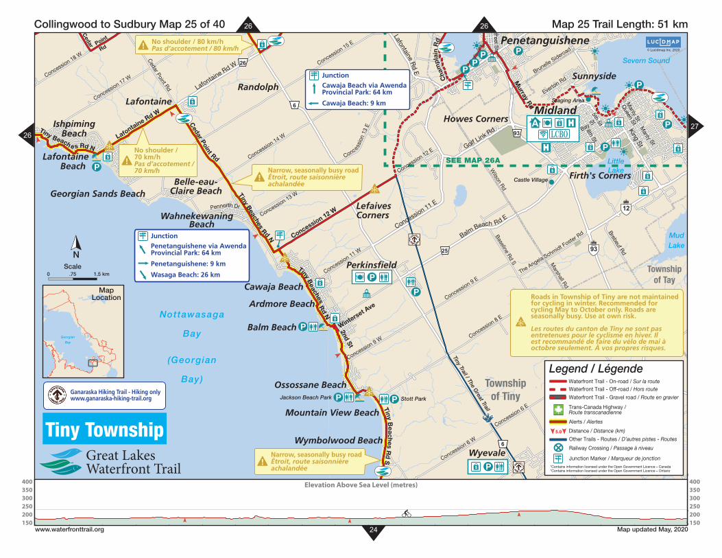
Roads in Township of Tiny are not maintained for cycling in winter. Recommended for cycling May to October only. Roads are seasonally busy. Use at own risk.
Les routes du canton de Tiny ne sont pas entretenues pour le cyclisme en hiver. Il est recommandé de faire du vélo de mai à octobre seulement. À vos propres risques.
Georgian
Bay
MapLocation
Ganaraska Hiking Trail - Hiking onlywww.ganaraska-hiking-trail.org
5.0
Waterfront Trail - On-road / Sur la routeWaterfront Trail - Off-road / Hors route
Waterfront Trail - Gravel road / Route en gravier
Trans-Canada Highway /Route transcanadienne
Other Trails - Routes / D’autres pistes - Routes
Railway Crossing / Passage à niveau
Alerts / Alertes
Distance / Distance (km)
Legend / Légende
Junction Marker / Marqueur de jonction*Contains information licensed under the Open Government Licence – Canada*Contains information licensed under the Open Government Licence – Ontario
400350300250200150
400350300250200150
Elevation Above Sea Level (metres)
5.0
Waterfront Trail - On-road / Sur la route
Waterfront Trail - Off-road / Hors routeWaterfront Trail - Gravel road / Route en gravier
Other Trails - Routes / D’autres pistes - Routes
Railway Crossing / Passage à niveau
Alerts / Alertes
Distance / Distance (km)
Legend / Légende
*Contains information licensed under the Open Government Licence – Canada*Contains information licensed under the Open Government Licence – Ontario
Waterfront Trail - Proposed / Proposée
26
24
SEE MAP 26A
$
P
P
$
$
$
$
$
P
$
P
PP
P
P
P
PP
$
$
P
$
$
$
6
6
93
12
93
25
26
! No shoulder / 80 km/hPas d’accotement / 80 km/h
!Narrow, seasonally busy roadÉtroit, route saisonnièreachalandée
!Narrow, seasonally busy roadÉtroit, route saisonnièreachalandée
!No shoulder /70 km/hPas d’accotement /70 km/h
JunctionPenetanguishene via AwendaProvincial Park: 64 km
Penetanguishene: 9 km
Wasaga Beach: 26 km
JunctionCawaja Beach via AwendaProvincial Park: 64 km
Cawaja Beach: 9 km
A $
LCBO
P
$ P
Castle Village
Staging Area
Tiny Trail / The Great Trail
Stott ParkJackson Beach Park
Georgian Sands Beach
Ardmore Beach
Wahnekewaning Beach
Mountain View Beach
Randolph
Belle-eau-Claire Beach
Wymbolwood Beach
Firth's Corners
Ossossane Beach
BeachLafontaine
Wyevale
Wyebridge
IshpimingBeach
Sunnyside
LefaivesCorners
Howes Corners
Perkinsfield
Lafontaine
Balm Beach
Cawaja Beach
Midland
Penetanguishene
Concession 11 E
Balm Beach Rd E
Lafontaine Rd W
Golf Link Rd
Lafontaine Rd E
King St
Concession 17 WM
anly StConcession 18 W
Marshall Rd
Brunelle Sideroad
Wilson Rd
The Angela Schmidt Foster R
d
Brebeuf Rd
Concession 6 W
Cedar Point Rd
Concession 6 E
Concession 9 E
5th St
Murray R
d
Lafontaine Rd W
Concession 13 W
Concession 11 W
Concession 12 W
Concession 14 W
Concession 15 E
Pennorth Dr
Everton Rd
Peel S
t
Manly St
Queen St
Concession 8 E
Baseline R
d S
Concession 9 W
Bay St
8th St
Cedar P
oint
Rd
Cedar Point Rd
Tiny Beaches Rd N
Tiny Beach es Rd N
Tiny Beaches R
d S
Tiny Beaches R
d N
Winterset Ave
2nd St
Concession 12 EConcess
ion
13 E
Cha
mpl
ain
Rd
Townshipof Tay
Townshipof Tiny
Severn Sound
MudLake
LittleLake
Nottawasaga
Bay
(Georgian
Bay)
© Lucidmap Inc. 2020
N
Map 25 Trail Length: 51 km Collingwood to Sudbury Map 25 of 40
www.waterfronttrail.org Map updated May, 2020
Tiny Township
Elevation Above Sea Level (metres)
27
kmScale
26
26
Georgian
Bay
MapLocation Roads in Township of Tiny are not maintained
for cycling in winter. Recommended for cycling May to October only. Roads are seasonally busy. Use at own risk.
Les routes du canton de Tiny ne sont pas entretenues pour le cyclisme en hiver. Il est recommandé de faire du vélo de mai à octobre seulement. À vos propres risques.
Ganaraska Hiking Trail - Hiking onlywww.ganaraska-hiking-trail.org
5.0
Waterfront Trail - On-road / Sur la routeWaterfront Trail - Off-road / Hors route
Waterfront Trail - Gravel road / Route en gravier
Trans-Canada Highway /Route transcanadienne
Other Trails - Routes / D’autres pistes - Routes
Railway Crossing / Passage à niveau
Alerts / Alertes
Distance / Distance (km)
Legend / Légende
Junction Marker / Marqueur de jonction*Contains information licensed under the Open Government Licence – Canada*Contains information licensed under the Open Government Licence – Ontario
5.0
Waterfront Trail - On-road / Sur la route
Waterfront Trail - Off-road / Hors routeWaterfront Trail - Gravel road / Route en gravier
Other Trails - Routes / D’autres pistes - Routes
Railway Crossing / Passage à niveau
Alerts / Alertes
Distance / Distance (km)
Legend / Légende
*Contains information licensed under the Open Government Licence – Canada*Contains information licensed under the Open Government Licence – Ontario
Waterfront Trail - Proposed / Proposée
25
SEE MAP 26A
6
26
26
93
! Soft shoulders / 80 km/hDoux d’accotement / 80 km/h
! No shoulder / 80 km/hPas d’accotement / 80 km/h
!Narrow, seasonally busy roadÉtroit, route saisonnièreachalandée
!No shoulder /70 km/hPas d’accotement /70 km/h
Steep HillPente escarpée
Steep HillPente escarpée
JunctionCawaja Beach via AwendaProvincial Park: 64 km
Cawaja Beach: 9 km
A $
LCBO
$ LCBO
P
Staging Area
Christian IslandFerry
Staging Area
Tiny
Tra
il / T
he Gre
at Tra
il
DiscoveryHarbour
P P
$
$
P
$
P
PP
P
$
$
P
$
P
$
$
Midland
Penetanguishene
Georgian Highlands
Thunder Beach
Highland Point
Cove Beach
Marygrove
Randolph
Kettle's BeachClearwater Beach
KingswoodAcres
Silver BirchBeach
Cedar Point
Sunnyside
Toanche
Howes Corners
SawlogBay
Peekaboo Point
Coutnac Beach
BeachPetaguishene
Northwest Basin
Lafontaine
IshpimingBeach
Mac
Ava
lley
Rd
Concession 19 W
Silver Birch D
r
Hillcrest R
d Thunder Beach Rd
Bay St
Methodist Point R
d
N Shore Dr
Concession 15 W
Champlain R
d
Concession 17 E
Awenda
Park R
dDorio
n Rd
5th St
Murray R
d
Military Rd
Cham
pla in Rd
Concession 18 W
Lafontaine Rd W
Concession 18 W
W S
hore
Dr
Tinney Dr
Concession 14 W
Concession 15 E
Chem
in du Loup Rd
Bush Rd
Yeo St
8th St
Tiny Beaches R d N
Cedar Point R
d
Cedar Point R
d
Green Point Rd
Champlain Rd
Ch
amp
lain
Rd
Lafo
ntaine Rd E
Cedar P
oint Rd
Farla in Lake Rd E
Awenda Park
Rd
Kettle’s B
each
Rd
Tiny B
ea
ches Rd N
Lafontaine Rd E
Lafontaine Rd W
Golf Link Rd
Fuller Ave
Chu
rch
St
Broad St
Sandy Bay Rd
Concession 16 E Fox S
t
Con
cess
ion
13 E
Townshipof Tiny
Awenda Provincial Park
OuterHarbour
GEORGIAN BAY
Christian
Channel
Thunder
Bay
Pen
eta
ng
uis
he
ne
H
arb
ou
r
FarlainLake
KettleLake
© Lucidmap Inc. 2020
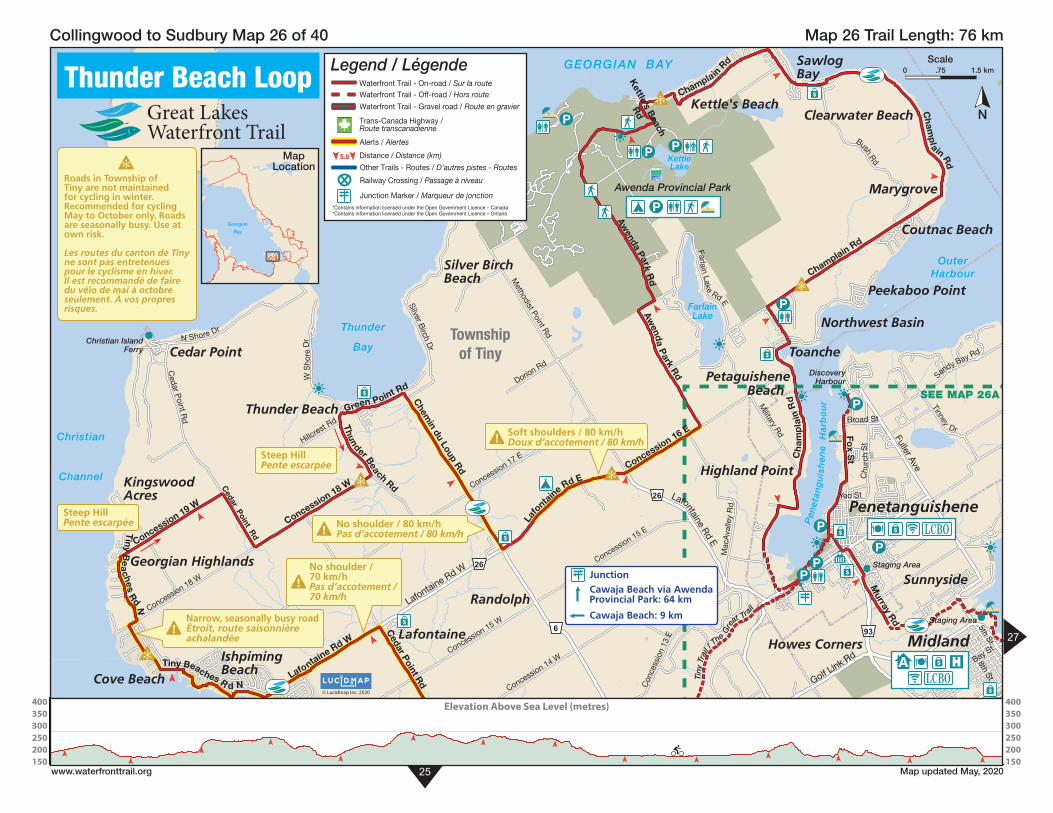
Thunder Beach LoopN
Map 26 Trail Length: 76 km Collingwood to Sudbury Map 26 of 40
www.waterfronttrail.org Map updated May, 2020
400350300250200150
400350300250200150
Elevation Above Sea Level (metres)
27
kmScale
Roads in Township of Tiny are not maintained for cycling in winter. Recommended for cycling May to October only. Roads are seasonally busy. Use at own risk.
Les routes du canton de Tiny ne sont pas entretenues pour le cyclisme en hiver. Il est recommandé de faire du vélo de mai à octobre seulement. À vos propres risques.
Georgian
Bay
MapLocation
5.0
Waterfront Trail - On-road / Sur la routeWaterfront Trail - Off-road / Hors route
Waterfront Trail - Gravel road / Route en gravier
Trans-Canada Highway /Route transcanadienne
Other Trails - Routes / D’autres pistes - Routes
Railway Crossing / Passage à niveau
Alerts / Alertes
Distance / Distance (km)
Legend / Légende
Junction Marker / Marqueur de jonction*Contains information licensed under the Open Government Licence – Canada*Contains information licensed under the Open Government Licence – Ontario

5.0
Waterfront Trail - On-road / Sur la route
Waterfront Trail - Off-road / Hors routeWaterfront Trail - Gravel road / Route en gravier
Other Trails - Routes / D’autres pistes - Routes
Railway Crossing / Passage à niveau
Alerts / Alertes
Distance / Distance (km)
Legend / Légende
*Contains information licensed under the Open Government Licence – Canada*Contains information licensed under the Open Government Licence – Ontario
Waterfront Trail - Proposed / Proposée
26
27
93
26
! Soft shoulders / 80 km/hDoux d’accotement / 80 km/h
Steep HillPente escarpée
JunctionCawaja Beach via AwendaProvincial Park: 64 km
Cawaja Beach: 9 km
$ LCBO
A $
LCBO
PenetanguisheneCentennial Museum
Penetang Arena
StagingArea
Huronia Museum andHuron Ouendat Village
Tiny T
rail /
The
Gre
at Trail
DiscoveryHarbour
$
P
P
P
$
$
$
$
P
P
P
$
P$
P
P
P
P
P
$
$
Tiffin
Portage Park
Highland Point
Midland Point
Sunnyside
Howes Corners
Midland
Penetanguishene
Overhead Bridge Rd
Robert St E
Yonge St
Vindin St
Golf Link Rd
Main St
Fuller Ave
Fuller Ave
Lafontaine Rd E
Robert St W
King St
4th St
William
St
Midland Ave
Manly St
Brule St
Shanahan Rd
Penetanguishene Rd
Ottawa St
1st St
Mac
Ava
lley
Rd
Tay Point Rd
Puddicombe R
d
Brunelle Sideroad
Kin
gfis
her C
res
Curry Rd
Robbs Rd
Beck
Blv
d
Anne StEllen St
Richelieu St
Chu
rch
St
Harriet St
5th St
Oxley Dr
Cambridge St
6th St
Montreal S
tVictoria St
Quebec St
Military Rd
Ontario St
Zoschke Dr
Tinney Dr
Dufferin S
t
Thompsons Rd
Bay
shor
e
Dr
2nd St
3rd St
Maria St
Cook Dr
W
hip Poor W
ill Dr
Timberland Crt
Everton Rd
Murray R
d
John St
Par 4 Dr
Burke St
Centre St
Poyntz St
Don St
Pine Grove Rd
Alvin Willia
ms Rd
Hanly StScott St
Jury Dr
Laurier R
d
Gawley Dr
Lorn
e A
ve
Copeland Creek Dr
Park St
Manly St
Aberdeen Blvd
Queen St
Birchwood Dr
Yeo St
Dominion Ave
7th St
Elizabeth St
8th St
George StBay St
James St
Marine Park Ave
Peel S
tHugel A
ve
Conce
ssion 13 E
Yonge St
Concession 16 E
Chu
rch
St
Sandy Bay Rd
Cha
mpl
ain
Rd
Fox S
t
Galloway Blvd
William
St
Mid
land Point R
d
Ch
am
pla
in R
d
Main St
Harbourview
Dr
Broad St
Townshipof Tiny
Midland Golf &Country Club
Severn
Sound
St.Andrews
Lake
LittleLake
Midland
Bay
Pe
ne
tan
gu
ish
en
e
H
arb
ou
r
© Lucidmap Inc. 2020
N
Map 26A Trail Length: 27 km Collingwood to Sudbury Map 26A of 40
www.waterfronttrail.org Map updated May, 2020
Penetanguishene$ LCBO
25
Km0 1.5
MidlandA $ LCBOGeorgian
Bay
MapLocation
5.0
Waterfront Trail - On-road / Sur la routeWaterfront Trail - Off-road / Hors route
Waterfront Trail - Gravel road / Route en gravier
Trans-Canada Highway /Route transcanadienne
Other Trails - Routes / D’autres pistes - Routes
Railway Crossing / Passage à niveau
Alerts / Alertes
Distance / Distance (km)
Legend / Légende
Junction Marker / Marqueur de jonction*Contains information licensed under the Open Government Licence – Canada*Contains information licensed under the Open Government Licence – Ontario
400350300250200150
400350300250200150
Elevation Above Sea Level (metres)
5.0
Waterfront Trail - On-road / Sur la route
Waterfront Trail - Off-road / Hors routeWaterfront Trail - Gravel road / Route en gravier
Other Trails - Routes / D’autres pistes - Routes
Railway Crossing / Passage à niveau
Alerts / Alertes
Distance / Distance (km)
Legend / Légende
*Contains information licensed under the Open Government Licence – Canada*Contains information licensed under the Open Government Licence – Ontario
Waterfront Trail - Proposed / Proposée
28
SE
E M
AP
26
A
SEE INSET
23
23
12
12
400
17
17
17
16
58
58
400
12
400
12
17
! Soft shoulder / 80 km/hDoux d’accotement / 80 km/h
! No shoulder / 80 km/hPas d’accotement / 80 km/h
! Narrow BridgePont étroit
Junction
Waubaushene: 8 kmWaubaushene viaBig Chute Loop: 65 km
Orillia: 25 km andGravenhurst: 69 km
Junction
Coldwater via BigChute Loop: 65 km
Coldwater: 8 kmA $
$ LCBOP
SS Kewatin
Wye MarshWildlife Centre
Ste-Marie amongthe Hurons
Martyr’sShrine
St-Louis MissionNational Historic Site
Staging Area
CenotaphParkette
Coldwater Arena
Ganaraska Trail
Ganaraska Trail
Simcoe County Loop Trail
$
P
P
$
$
$
$
P
P
P$
P
P$
P
P$
Grandview Beach
EbenezerRiverside
Fesserton
Vasey
Sturgeon Beach
Sunset Beach
Port McNicoll
Waubaushene
Forest Harbour
Elliotts Corners
Ogden’sBeach
Coldwater
$ PLCBO
Victoria Harbour$ LCBO
4th Ave
Wood
row R
d
Line 8 N
Old Coach Rd
F R N
elson Rd
Duck Bay Rd
Southorn Rd
Lawson Line
Peter St W
Quarry Rd
Kinnear Sideroad
Laughlin Falls Rd
Rumney Rd
Line 5 N
Line 7
Hogg Valley Rd
New
ton St
Reeves Rd
Gratrix Rd
Sandhill Rd
Simcoe Ave
Wood Rd
Irish Line
Albert St
Hodgins Rd
Anderson Line
Line 4 N
Line 6 N
Rosemount Rd
Line 9 N
Dunns Line
Elliott S
ideroad
Ron Jones Rd
Park St
Arpin St
7th Ave
Forgets
Rd
Ebenezer S
ideroad
Quarry Rd
Quarry Rd
Tanners RdGratrix RdTalbot S
t
Ney A
ve
Robin
s Poi
nt Rd
Hoy
t Ave
Bass
Bay Dr
Fesserton
Sideroad
Albin Rd
Col
dwat
erR
d
Ellen St
Gray St
George
St
Triple Bay Rd
1st AveOgden’s Beach R
d
Gervais Rd
Vasey Rd
Upper Big C
hute Rd
Upper Big Chute Rd
Old Fort Rd
Sturgeon
Bay Rd
Vasey Rd
Township ofSevern
Township ofOro-Medonte
Townshipof Tay
Hogg
Bay
Sturgeon
Bay
Severn Sound
Matchedash
Bay
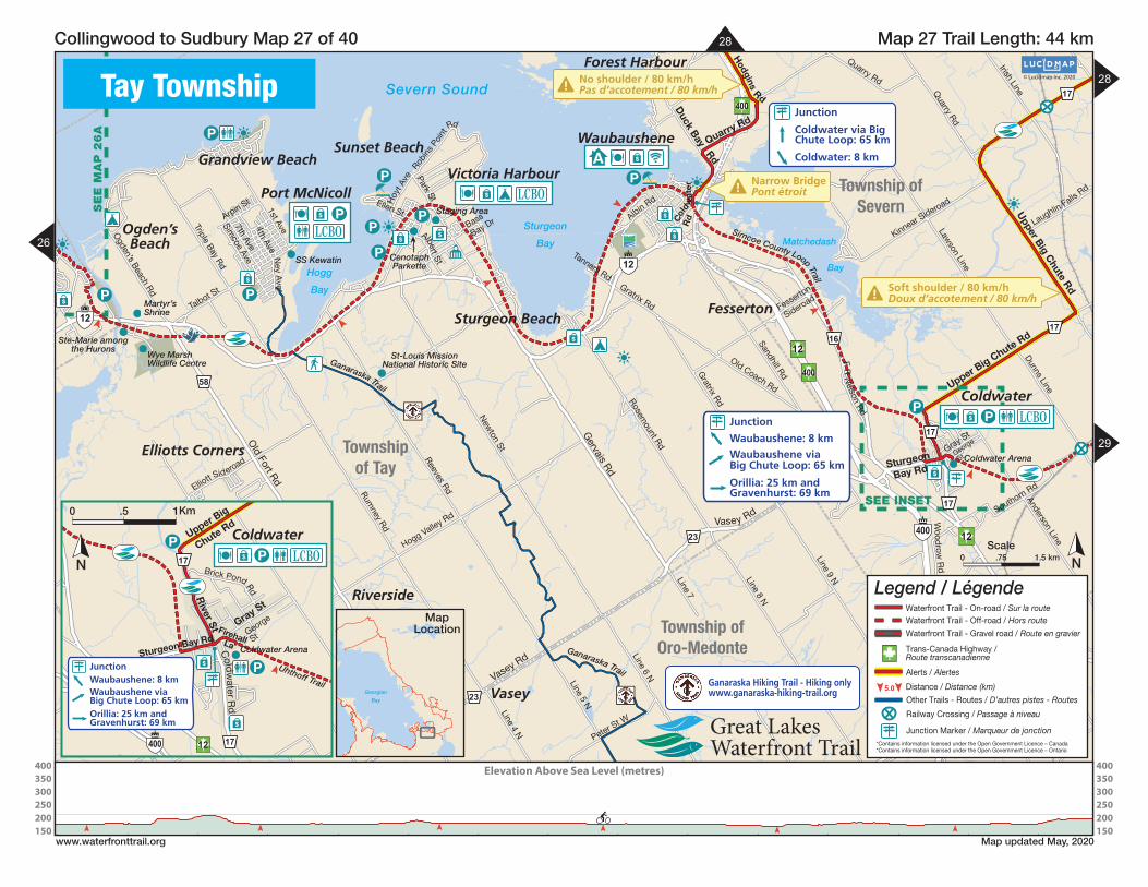
© Lucidmap Inc. 2020Tay Township
NkmScale
Map 27 Trail Length: 44 km Collingwood to Sudbury Map 27 of 40
www.waterfronttrail.org Map updated May, 2020
26
29
Elevation Above Sea Level (metres)
28
17
17
400 12
JunctionWaubaushene: 8 kmWaubaushene viaBig Chute Loop: 65 kmOrillia: 25 km andGravenhurst: 69 km
$ LCBOP
Coldwater Arena
Uhthoff Trail
$
P
P
$
Coldwater
Gray St
George
St
Brick Pond Rd
Upper Big
Chute Rd
Sturgeon Bay Rd
River St
Cold
water R
d
FirehallLa
N
Km0 1.5
Georgian
Bay
MapLocation
Ganaraska Hiking Trail - Hiking onlywww.ganaraska-hiking-trail.org 5.0
Waterfront Trail - On-road / Sur la routeWaterfront Trail - Off-road / Hors route
Waterfront Trail - Gravel road / Route en gravier
Trans-Canada Highway /Route transcanadienne
Other Trails - Routes / D’autres pistes - Routes
Railway Crossing / Passage à niveau
Alerts / Alertes
Distance / Distance (km)
Legend / Légende
Junction Marker / Marqueur de jonction*Contains information licensed under the Open Government Licence – Canada*Contains information licensed under the Open Government Licence – Ontario
400350300250200150
400350300250200150
Elevation Above Sea Level (metres)
5.0
Waterfront Trail - On-road / Sur la route
Waterfront Trail - Off-road / Hors routeWaterfront Trail - Gravel road / Route en gravier
Other Trails - Routes / D’autres pistes - Routes
Railway Crossing / Passage à niveau
Alerts / Alertes
Distance / Distance (km)
Legend / Légende
*Contains information licensed under the Open Government Licence – Canada*Contains information licensed under the Open Government Licence – Ontario
Waterfront Trail - Proposed / Proposée
5
5
48
34 17
17
400
400
12
Busy intersectionsTraversées occupée1
Narrow BridgesPonts étroit2
1
Busy intersectionsTraversées occupée1
! Soft shoulder / 80 km/hDoux d’accotement / 80 km/h
! No shoulder / 80 km/hPas d’accotement / 80 km/h
Junction
HoneyHarbour: 4 km
A $
A $
DaytripperFerry to
Georgian BayIslands
National Park
Big Chute MarineRailway / Trent-Severn Lock #44
Georgian Bay Islands
National
Park
Six Mile LakeProvincial Park
Trent-SevernLock #45
P
PP
P
$
P
?
P
P$
$
P
Buckskin
WolverineBeach
Severn Falls
BigChute
Mordolphin
Forest Harbour
Port Severn
Maceys Bay
Honey Harbour
Tow
er
Line
Rd
Irish Line
Tobys Rd
Narrow
s Rd
Joe Kings Rd
Quarry Rd
Fell Line
Taylor Line
Frankland Lane
Whi
te Pi nes R
d
Macey Bay Rd
Sunri
se Trail
Hodgins R
d
Janes Lane
Elli
s R
d
Lodge Rd
Saint Amant Rd
E Sh
ore Rd
Silk Line
Graham R
d
Bass Bay Rd
Mus
ky Bay Rd
Lavalley Way
Baxter L
oop R d
Kings Farm
Rd
Nicholson Rd
S Bay Rd Whites Falls R
d
Honey Harbour Rd
Honey Harbour R
d
Up per B
ig C
hute
Rd
Upper Big Chute Rd
Upper Big Chute Rd
Port S evernRd N
Port
SevernR
d
Township ofSevernTownship of
Georgian Bay
Townshipof Tay
Township ofMuskoka Lakes
Severn
Sound
Six MileLake
GloucesterPool
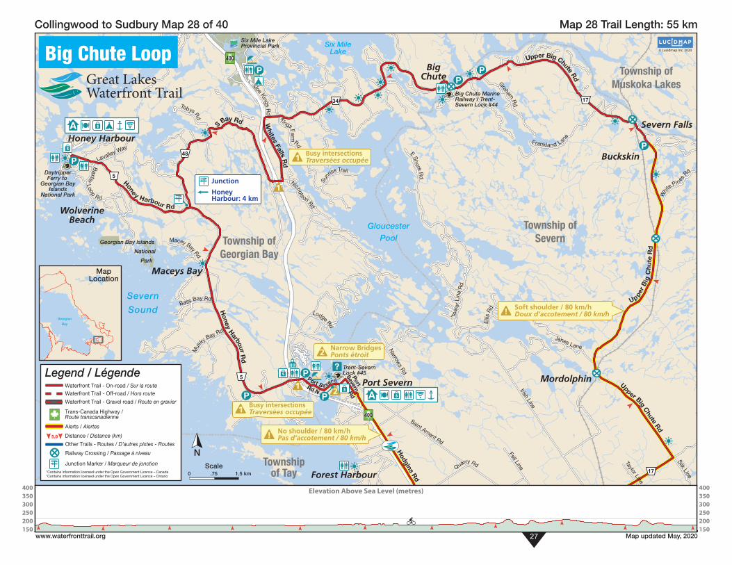
© Lucidmap Inc. 2020Big Chute Loop
N
Map 28 Trail Length: 55 km Collingwood to Sudbury Map 28 of 40
www.waterfronttrail.org Map updated May, 202027
kmScale
Elevation Above Sea Level (metres)
Georgian
Bay
MapLocation
5.0
Waterfront Trail - On-road / Sur la routeWaterfront Trail - Off-road / Hors route
Waterfront Trail - Gravel road / Route en gravier
Trans-Canada Highway /Route transcanadienne
Other Trails - Routes / D’autres pistes - Routes
Railway Crossing / Passage à niveau
Alerts / Alertes
Distance / Distance (km)
Legend / Légende
Junction Marker / Marqueur de jonction*Contains information licensed under the Open Government Licence – Canada*Contains information licensed under the Open Government Licence – Ontario
400350300250200150
400350300250200150
Elevation Above Sea Level (metres)
5.0
Waterfront Trail - On-road / Sur la route
Waterfront Trail - Off-road / Hors routeWaterfront Trail - Gravel road / Route en gravier
Other Trails - Routes / D’autres pistes - Routes
Railway Crossing / Passage à niveau
Alerts / Alertes
Distance / Distance (km)
Legend / Légende
*Contains information licensed under the Open Government Licence – Canada*Contains information licensed under the Open Government Licence – Ontario
Waterfront Trail - Proposed / Proposée
30
SEE MAP 29A
11
11
2212
12
Junction
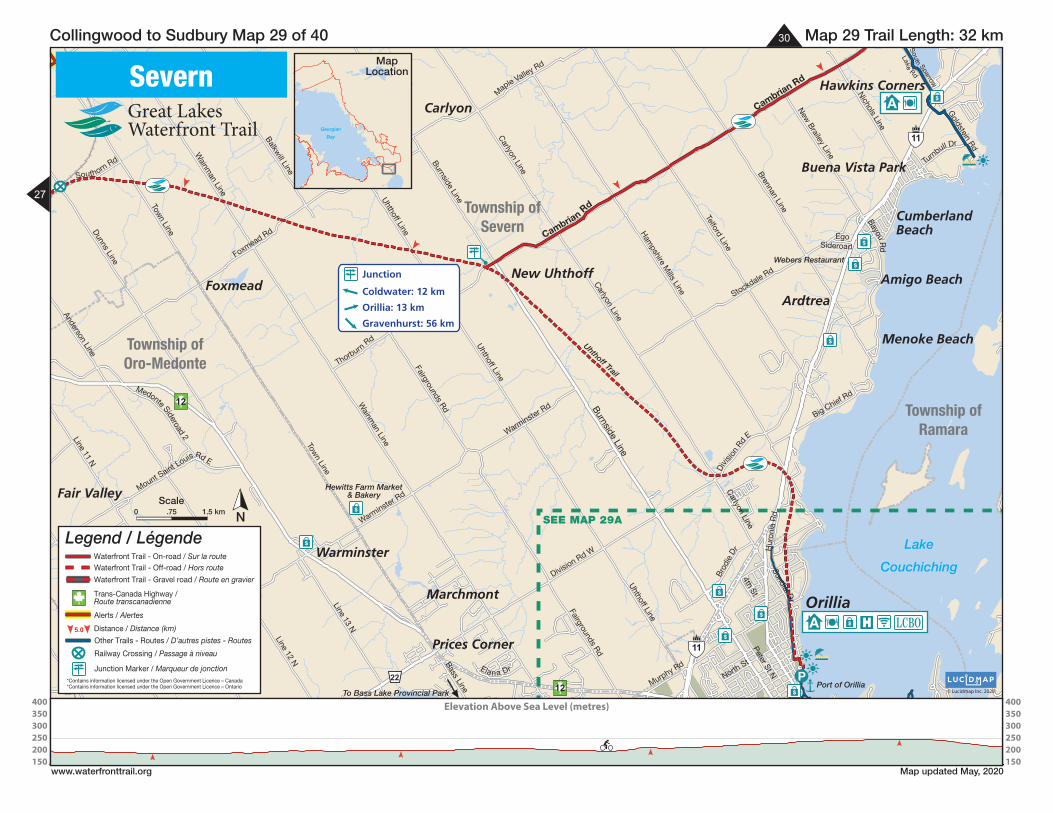
Coldwater: 12 km
Orillia: 13 km
Gravenhurst: 56 km
A $ LCBO
A
Webers Restaurant
Uhthoff Trail
Hewitts Farm Market& Bakery
Port of OrilliaTo Bass Lake Provincial Park
$
P
$
$
$
$
$
$
$
$
$
Orillia
New Uhthoff
Menoke Beach
Hawkins Corners
Warminster
Carlyon
Fair Valley
Foxmead
Prices Corner
Amigo Beach
CumberlandBeach
Marchmont
Buena Vista Park
Ardtrea
Line 12 N Bass Line
Peter St N
Burnside Line
Thorburn R
d
Warminster R
d
Medonte Sideroad 2
Warminster R
d
New
Brailey Line
Nichols Line
Brennan Line
Big Chief Rd
Elana Dr
Ham
pshire Mills Line
Turnbull Dr
4th St
Sundial D
r
Line 11 N
Foxmead Rd
Uhthoff Line
Murphy Rd
Fairgrounds Rd
Balkwill Line
Mount Saint L
ouis Rd E
Anderson LineD
unns Line
Telford Line
Stockdale Rd
Carlyon Line
Wainm
an Line
M
aple Valley Rd
Town Line
Line 13 N
North St
Hur
onia
Rd
Bayou Rd
Uhthoff Line
Uhthoff Line
Town Line
Wainm
an Line
Southorn Rd
Goldstein Rd
EgoSideroad
Fairgrounds Rd
Carlyon Line
Bro
die
Dr
Carlyon Line
Division Rd W
Divi
sion
Rd
E
Burnside Line
Cambrian Rd
Cambrian R
d
South Sparrow
Lake Rd
Township ofSevern
Township ofRamara
Township ofOro-Medonte
Lake
Couchiching
© Lucidmap Inc. 2020
Severn
N
Map 29 Trail Length: 32 km Collingwood to Sudbury Map 29 of 40
www.waterfronttrail.org Map updated May, 2020
Elevation Above Sea Level (metres)
27
kmScale
Georgian
Bay
MapLocation
5.0
Waterfront Trail - On-road / Sur la routeWaterfront Trail - Off-road / Hors route
Waterfront Trail - Gravel road / Route en gravier
Trans-Canada Highway /Route transcanadienne
Other Trails - Routes / D’autres pistes - Routes
Railway Crossing / Passage à niveau
Alerts / Alertes
Distance / Distance (km)
Legend / Légende
Junction Marker / Marqueur de jonction*Contains information licensed under the Open Government Licence – Canada*Contains information licensed under the Open Government Licence – Ontario
5.0
Waterfront Trail - On-road / Sur la route
Waterfront Trail - Off-road / Hors routeWaterfront Trail - Gravel road / Route en gravier
Other Trails - Routes / D’autres pistes - Routes
Railway Crossing / Passage à niveau
Alerts / Alertes
Distance / Distance (km)
Legend / Légende
*Contains information licensed under the Open Government Licence – Canada*Contains information licensed under the Open Government Licence – Ontario
Waterfront Trail - Proposed / Proposée
29
11
11
44
11
12
12
12
12
A $ LCBO
Brian OrserArena
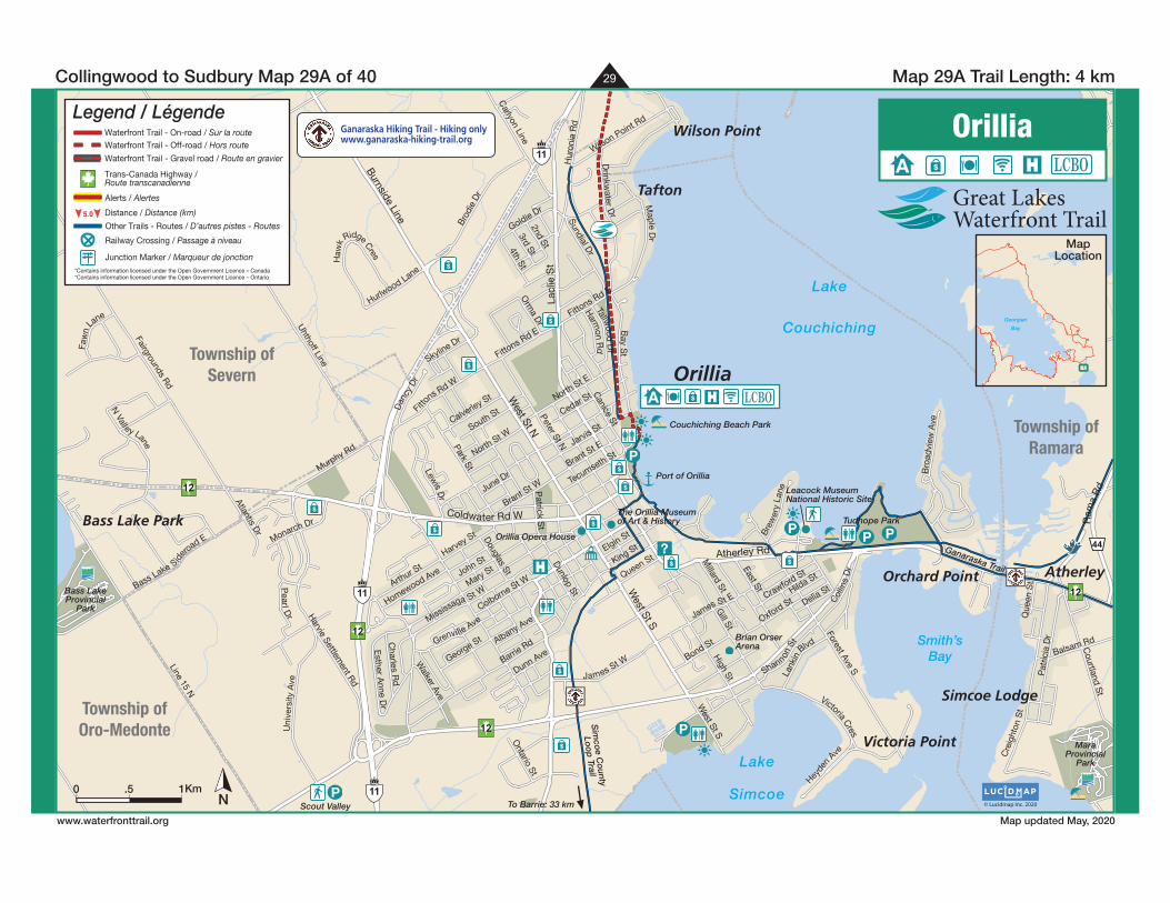
The Orillia Museumof Art & History
Orillia Opera House
Leacock MuseumNational Historic Site
MaraProvincial
Park
Sim
coe C
ounty
Loo
p Trail
Bass LakeProvincial
Park
Scout Valley
Port of Orillia
Couchiching Beach Park
Ganaraska Trail
Tudhope Park
To Barrie: 33 km
$
$
P
$
P
$
P
?$
$
$
$
PPP$
$
$
$
Orillia
Wilson Point
Orchard Point Atherley
Bass Lake Park
Victoria Point
Tafton
Simcoe Lodge
Grenville Ave
Calverley St
Atlantis Dr
Dunn Ave
Wilson Point Rd
3rd StPeter St N
Que
en S
t
June Dr
Dunlop St
Heyde
n Ave
Balsam Rd
Esther A
nne Dr
George St Albany Ave
James St W
Bre
wer
y La
neLa
nkin
Blvd
High St
Harm
on Rd
Uni
vers
ity A
ve
Brant St W
Park St
Canice St
Dan
cy D
r
Faw
n
Lane
Harvey St
Colborne St W
Col
lins
Dr
James S t E Delia StHilda St
Victoria Cres
Shannon S
t
Tallwood
Dr
Charles R
d
Monarch Dr
Pearl D
r
Ontario St
4th St
Skyline Dr
2nd St
Bro
advi
ew A
ve
Sundial D
r
Hurlwood Lane
Uhthoff Line
Murphy Rd
Cre
ight
on S
t
Oxford St
Forest Ave S
N Valley Lane
South St
North St E
Millard St
Crawford St
Homewood AveArth
ur St
Harvie Settlem
ent Rd
Cedar St
Patrick S
t
Lewis D
r
Maple D
r
Fittons Rd E
Drinkw
ater Dr
Orm
a Dr
Queen StElgin St
Jarvis St
Bass Lake S
idero
ad E
Walker Ave
Haw
k
Ridge Cres
North St W
Hur
onia
Rd
Bond St
West St S
Mary St
Douglas StJohn St
Pat
ricia
Dr
Brant St E
Goldie Dr
Tecumseth St
East St
Bay S
t
Burnside Line
Ram
a R
d
Lacl
ie S
t
Coldwater Rd W
West St N
West St S
Atherley Rd
Fairgrounds RdLine 15 N
Bro
die
Dr
Fitto
ns Rd W
King St
Carlyon Line
Division Rd W
Courtland S
t
Gill St
Fittons Rd E
Mississaga St W
Barrie Rd
Township ofSevern
Township ofRamara
Township ofOro-Medonte
Lake
Couchiching
Smith’sBay
Lake
Simcoe© Lucidmap Inc. 2020
Orillia
N
Map 29A Trail Length: 4 km Collingwood to Sudbury Map 29A of 40
www.waterfronttrail.org Map updated May, 2020
A $ LCBO
Km0 1.5
Georgian
Bay
MapLocation
5.0
Waterfront Trail - On-road / Sur la routeWaterfront Trail - Off-road / Hors route
Waterfront Trail - Gravel road / Route en gravier
Trans-Canada Highway /Route transcanadienne
Other Trails - Routes / D’autres pistes - Routes
Railway Crossing / Passage à niveau
Alerts / Alertes
Distance / Distance (km)
Legend / Légende
Junction Marker / Marqueur de jonction*Contains information licensed under the Open Government Licence – Canada*Contains information licensed under the Open Government Licence – Ontario
Ganaraska Hiking Trail - Hiking onlywww.ganaraska-hiking-trail.org