Embed Size (px)
Citation preview
Site Structure of a Village of the Late Pithouse-Early Pueblo Period in New MexicoAuthor(s): Vernon L. ScarboroughSource: Journal of Field Archaeology, Vol. 16, No. 4 (Winter, 1989), pp. 405-425Published by: Boston UniversityStable URL: http://www.jstor.org/stable/530278Accessed: 18/10/2010 15:41
Your use of the JSTOR archive indicates your acceptance of JSTOR's Terms and Conditions of Use, available athttp://www.jstor.org/page/info/about/policies/terms.jsp. JSTOR's Terms and Conditions of Use provides, in part, that unlessyou have obtained prior permission, you may not download an entire issue of a journal or multiple copies of articles, and youmay use content in the JSTOR archive only for your personal, non-commercial use.
Please contact the publisher regarding any further use of this work. Publisher contact information may be obtained athttp://www.jstor.org/action/showPublisher?publisherCode=boston.
Each copy of any part of a JSTOR transmission must contain the same copyright notice that appears on the screen or printedpage of such transmission.
JSTOR is a not-for-profit service that helps scholars, researchers, and students discover, use, and build upon a wide range ofcontent in a trusted digital archive. We use information technology and tools to increase productivity and facilitate new formsof scholarship. For more information about JSTOR, please contact [email protected].
Boston University is collaborating with JSTOR to digitize, preserve and extend access to Journal of FieldArchaeology.
http://www.jstor.org
405
Site Structure of a Village of the Late Pithouse-Early Pueblo Period in New Mexico
Vernon L. Scarborough University of Cincinnati Cincinnati, Ohio
The period of change from pithouse to pueblo as the preferred dwelling in the American Southwest represents an architectural transition associated with greater complexity of com- munity organization. Excavation of more than 70% of the principal residential area within a small, single component, late Mogollon pithouse village (A.c. 1150-1200) in New Mexico (but located near El Paso, Texas) helps provide behavioral definition of this period. Through an examination of trash location and artifact size, feature-fill sequence reconstruction, and overall community plan, a "core activity area"for Meyer Pithouse Village has been estab- lished. This activity zone is the material correlate ofsupra-household cooperation, a condi- tion held necessary for the subsequent acceptance in antiquity ofpueblo room-block architec- ture similar to that of the neighboring Anasazi area.
Introduction The transition from pithouse to pueblo as the preferred
dwelling in the American Southwest has received consid- erable attention in recent literature (cf. Martin and Plog 1973; Plog 1974; Anyon 1980; Lipe and Breternitz 1980; Whalen 1981a; McGuire and Schiffer 1983; Cordell 1984; Shafer and Taylor 1986 ; Gilman 1987), with sev- eral themes emerging to explain this transition in archi- tecture and social organization. These explanations include the effects of 1) greater activity differentiation; 2) less household mobility and greater settlement longevity; 3) greater dependence on agriculture and the increased need for improved storage of foodstuffs; and 4) population growth. Most explanations assume that the transition ush- ered in a period of more structured, supra-family coop- eration.
Elsewhere in the world, similar architectural transitions associated with changes in social organization have been described with considerable energy having been invested in chronicling the movement away from circular-plan housing and dome-shaped domiciles towards rectangular residential architecture. Flannery (1972), for example, is careful to distinguish between the processes leading to
agriculture, incipient villages, and sedentism, and their clear associations with house form. In discussing the Me- soamerican village, he suggests an early adaptation involv-
ing a nuclear-family organizational unit associated with rectilinear housing. This condition is viewed as developing
from an earlier strategy based on mobility and very small
group size, and contrasts with the larger, more socially- flexible groups associated with Near Eastern settlements.
Flannery argues that early circular house forms of the first Southwest Asian villages are correlated with mobility and
larger group size. Similar house forms have not been found in Mesoamerica, where, according to Flannery, de-
veloped villages based on rectangular house plans were characteristic from the outset. In his view, rectilinear living units best accommodate the division of labor associated with self-sufficient nuclear family units. Flannery further
suggests that well-developed sodality organization would have bound together otherwise self-sufficient households so as to establish village-level identity.
Hunter-Anderson (1977), Robbins (1966), and Whit-
ing and Ayres (1968) indicate, for different reasons, that rectilinear structures are considerably more common
among villagers than hunter-gatherers. Hunter-Anderson (1977: 324) suggests that
the kind of organization of labor and consumption in which each family is a relatively self-sufficient, production-consump- tion unit is feasible when the certainty ... of resources is high. And housing these materials and facilities in family living space would probably result in a rectangular form.
In attempting to develop a theory for the design of vernacular architecture, McGuire and Schiffer (1983) spe- cifically examined the transition from pithouse to pueblo. They view pithouses as manifesting high maintenance
406 Village ofLate Pithouse-Early Pueblo Period/Scarborough
33 1063
C-
3 % ALAMOGOROO
Vo POINT OF
ROCKS
LAKE LUCERO E / o 'RINCON HILLS
S3JARILLA MTS.
DE LA A
_)WHITE SANOs OROGRANDE
LAS CRUCES "
00
LI CARMICHAEL
SURVEY TRACT
"" TRACT
\\48
REGIONAL CONTEXT OF STUDY ARECARM. MEXICO URVE
Adopted from Carmichael 1986 Drafted by L. Morston
Tn WHALEN
TRACT
NEW MEXICO - UNITED STATES EL PASO CHIHUAHUA - MEXICO
NEW MEXI I
I "• f IREGIONAL CONTEXT OF STUDY AREA
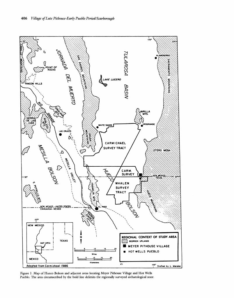
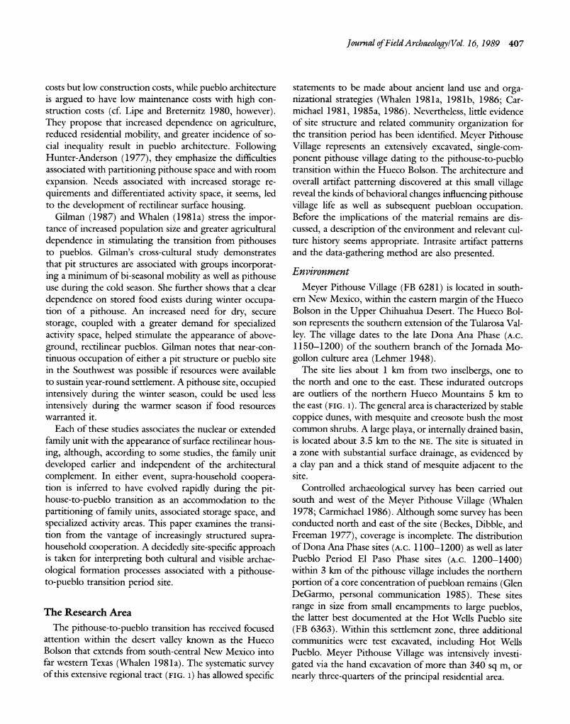
Figure 1. Map of Hueco Bolson and adjacent areas locating Meyer Pithouse Village and Hot Wells Pueblo. The area circumscribed by the bold line delimits the regionally surveyed archaeological zone.
Journal of Field Archaeology/Vol. 16, 1989 407
costs but low construction costs, while pueblo architecture is argued to have low maintenance costs with high con- struction costs (cf. Lipe and Breternitz 1980, however). They propose that increased dependence on agriculture, reduced residential mobility, and greater incidence of so- cial inequality result in pueblo architecture. Following Hunter-Anderson (1977), they emphasize the difficulties associated with partitioning pithouse space and with room
expansion. Needs associated with increased storage re-
quirements and differentiated activity space, it seems, led to the development of rectilinear surface housing.
Gilman (1987) and Whalen (1981a) stress the impor- tance of increased population size and greater agricultural dependence in stimulating the transition from pithouses to pueblos. Gilman's cross-cultural study demonstrates that pit structures are associated with groups incorporat- ing a minimum of bi-seasonal mobility as well as pithouse use during the cold season. She further shows that a clear
dependence on stored food exists during winter occupa- tion of a pithouse. An increased need for dry, secure
storage, coupled with a greater demand for specialized activity space, helped stimulate the appearance of above- ground, rectilinear pueblos. Gilman notes that near-con- tinuous occupation of either a pit structure or pueblo site in the Southwest was possible if resources were available to sustain year-round settlement. A pithouse site, occupied intensively during the winter season, could be used less
intensively during the warmer season if food resources warranted it.
Each of these studies associates the nuclear or extended family unit with the appearance of surface rectilinear hous- ing, although, according to some studies, the family unit developed earlier and independent of the architectural complement. In either event, supra-household coopera- tion is inferred to have evolved rapidly during the pit- house-to-pueblo transition as an accommodation to the partitioning of family units, associated storage space, and specialized activity areas. This paper examines the transi- tion from the vantage of increasingly structured supra- household cooperation. A decidedly site-specific approach is taken for interpreting both cultural and visible archae-
ological formation processes associated with a pithouse- to-pueblo transition period site.
The Research Area
The pithouse-to-pueblo transition has received focused attention within the desert valley known as the Hueco Bolson that extends from south-central New Mexico into far western Texas (Whalen 1981a). The systematic survey of this extensive regional tract (FIG. 1) has allowed specific
statements to be made about ancient land use and orga- nizational strategies (Whalen 1981a, 1981b, 1986; Car- michael 1981, 1985a, 1986). Nevertheless, little evidence of site structure and related community organization for the transition period has been identified. Meyer Pithouse Village represents an extensively excavated, single-com- ponent pithouse village dating to the pithouse-to-pueblo transition within the Hueco Bolson. The architecture and overall artifact patterning discovered at this small village reveal the kinds of behavioral changes influencing pithouse village life as well as subsequent puebloan occupation. Before the implications of the material remains are dis- cussed, a description of the environment and relevant cul- ture history seems appropriate. Intrasite artifact patterns and the data-gathering method are also presented.
Environment
Meyer Pithouse Village (FB 6281) is located in south- ern New Mexico, within the eastern margin of the Hueco Bolson in the Upper Chihuahua Desert. The Hueco Bol- son represents the southern extension of the Tularosa Val- ley. The village dates to the late Dona Ana Phase (A.c. 1150-1200) of the southern branch of the Jornada Mo- gollon culture area (Lehmer 1948).
The site lies about 1 km from two inselbergs, one to the north and one to the east. These indurated outcrops are outliers of the northern Hueco Mountains 5 km to the east (FIG. 1). The general area is characterized by stable coppice dunes, with mesquite and creosote bush the most common shrubs. A large playa, or internally drained basin, is located about 3.5 km to the NE. The site is situated in a zone with substantial surface drainage, as evidenced by a clay pan and a thick stand of mesquite adjacent to the site.
Controlled archaeological survey has been carried out south and west of the Meyer Pithouse Village (Whalen 1978; Carmichael 1986). Although some survey has been conducted north and east of the site (Beckes, Dibble, and Freeman 1977), coverage is incomplete. The distribution of Dona Ana Phase sites (A.c. 1100-1200) as well as later Pueblo Period El Paso Phase sites (A.c. 1200-1400) within 3 km of the pithouse village includes the northern portion of a core concentration of puebloan remains (Glen DeGarmo, personal communication 1985). These sites range in size from small encampments to large pueblos, the latter best documented at the Hot Wells Pueblo site (FB 6363). Within this settlement zone, three additional communities were test excavated, including Hot Wells Pueblo. Meyer Pithouse Village was intensively investi- gated via the hand excavation of more than 340 sq m, or nearly three-quarters of the principal residential area.
408 Village ofLate Pithouse-Early Pueblo Period/Scarborough
Culture History: Pithouse, Pithouse-to-Pueblo, and Pueblo Periods
The Formative Stage (A.C. 1-1400) in the Hueco Bol- son is initially defined by the early appearance of shallow
pithouse structures and Brown Ware ceramics. It con- cludes with the presumed abandonment of pueblo occu-
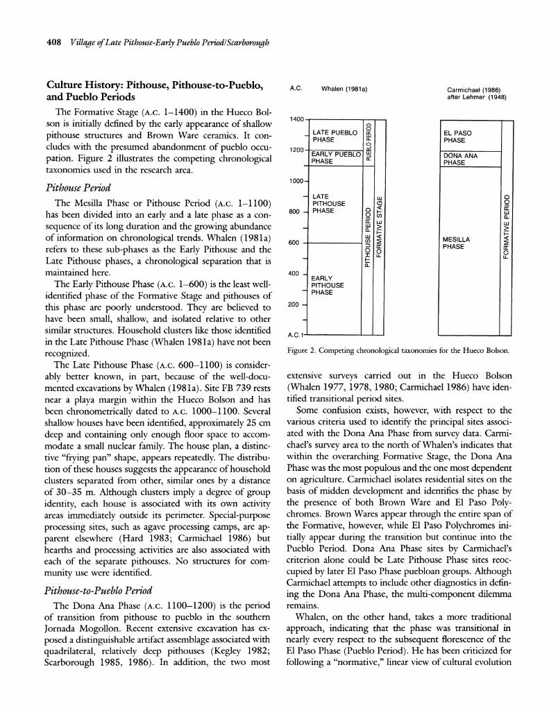
pation. Figure 2 illustrates the competing chronological taxonomies used in the research area.
Pithouse Period The Mesilla Phase or Pithouse Period (A.C. 1-1100)
has been divided into an early and a late phase as a con-
sequence of its long duration and the growing abundance of information on chronological trends. Whalen (1981a) refers to these sub-phases as the Early Pithouse and the Late Pithouse phases, a chronological separation that is maintained here.
The Early Pithouse Phase (A.C. 1-600) is the least well- identified phase of the Formative Stage and pithouses of this phase are poorly understood. They are believed to have been small, shallow, and isolated relative to other similar structures. Household clusters like those identified in the Late Pithouse Phase (Whalen 1981a) have not been
recognized. The Late Pithouse Phase (A.C. 600-1100) is consider-
ably better known, in part, because of the well-docu- mented excavations by Whalen (1981a). Site FB 739 rests near a playa margin within the Hueco Bolson and has been chronometrically dated to A.C. 1000-1100. Several shallow houses have been identified, approximately 25 cm
deep and containing only enough floor space to accom- modate a small nuclear family. The house plan, a distinc- tive "frying pan" shape, appears repeatedly. The distribu- tion of these houses suggests the appearance of household clusters separated from other, similar ones by a distance of 30-35 m. Although clusters imply a degree of group identity, each house is associated with its own activity areas immediately outside its perimeter. Special-purpose processing sites, such as agave processing camps, are ap- parent elsewhere (Hard 1983; Carmichael 1986) but hearths and processing activities are also associated with each of the separate pithouses. No structures for com- munity use were identified.
Pithouse-to-Pueblo Period
The Dona Ana Phase (A.C. 1100-1200) is the period of transition from pithouse to pueblo in the southern Jornada Mogollon. Recent extensive excavation has ex- posed a distinguishable artifact assemblage associated with quadrilateral, relatively deep pithouses (Kegley 1982; Scarborough 1985, 1986). In addition, the two most
A.C. Whalen (1981a) Carmichael (1986) after Lehmer (1948)
1400 o
LATE PUEBLO as EL PASO PHASE a- PHASE
1200 m EARLY PUEBLO u DONA ANA
PHASE PHASE
1000-
LATE w PITHOUSE c O
800- PHASE 0 F w
-W LU > w
600 MESILLA 60 PHASE Ic ?1u- 0
a- 400
EARLY PITHOUSE PHASE
200 -
A .C .1 -
Figure 2. Competing chronological taxonomies for the Hueco Bolson.
extensive surveys carried out in the Hueco Bolson
(Whalen 1977, 1978, 1980; Carmichael 1986) have iden- tified transitional period sites.
Some confusion exists, however, with respect to the various criteria used to identify the principal sites associ- ated with the Dona Ana Phase from survey data. Carmi- chael's survey area to the north of Whalen's indicates that within the overarching Formative Stage, the Dona Ana Phase was the most populous and the one most dependent on agriculture. Carmichael isolates residential sites on the basis of midden development and identifies the phase by the presence of both Brown Ware and El Paso Poly- chromes. Brown Wares appear through the entire span of the Formative, however, while El Paso Polychromes ini-
tially appear during the transition but continue into the Pueblo Period. Dona Ana Phase sites by Carmichael's criterion alone could be Late Pithouse Phase sites reoc-
cupied by later El Paso Phase puebloan groups. Although Carmichael attempts to include other diagnostics in defin-
ing the Dona Ana Phase, the multi-component dilemma remains.
Whalen, on the other hand, takes a more traditional
approach, indicating that the phase was transitional in
nearly every respect to the subsequent florescence of the El Paso Phase (Pueblo Period). He has been criticized for
following a "normative," linear view of cultural evolution
Journal of Field Archaeology/Vol. 16, 1989 409
in characterizing the Pithouse, Pithouse-to-Pueblo, and Pueblo Period sequence (Carmichael 1986; Reed 1987). Whalen's interpretations, however, appear to be based on empirical evidence drawn from controlled survey data.
Pueblo Period
Survey data again provide much of what we know about the Pueblo Period or the El Paso Phase of the southern Jornada Mogollon (A.C. 1200-1400). As intimated above, Carmichael (1986) identifies a decrease in the density of residential sites within his survey area as compared to the earlier Dona Ana Phase. He suggests that only 24% of the sites dating to the El Paso Phase are residential sites. Whalen (1981b), on the other hand, does not directly address the differences between the Dona Ana Phase and the El Paso Phase, but rather tends to lump the Dona Ana and El Paso phases together into a more broadly defined Pueblo Period that follows the earlier Pithouse Period.
In any event, Whalen (1981b) indicates that there exist three times more puebloan residential sites during his Pueblo Period than during the entire Pithouse Period, in spite of the fact that the Pithouse Period lasted three times longer. He further notes that only 10% of Pithouse Period residential sites are 3 ha or larger, while 49.5% of Pueblo Period residential sites are of that size (Whalen 1981b: 82). Not only are there more residential sites, they are larger.
In a further attempt to elucidate the demographic and social organization of the Formative Stage, Whalen (1981 la: 85) treated the number of hearths identified from Pithouse and Pueblo Period residential sites as an index of the number and kind of activities being carried out. He found that Pueblo Period hearths were larger on the av- erage, but clearly fewer in number (from 12.9 hearths per ha in residential sites during the Pithouse Period to 2.6 hearths per ha in residential sites during the Pueblo Pe- riod). Nor did Pueblo Period residential sites have roast- ing pits, a recurrent feature at Pithouse Period sites. These data have been interpreted as evidence for greater activity specialization at Pueblo Period sites; smaller camps are assumed to be the loci for special activities or tasks, for- merly performed at the less task-differentiated Pithouse Period residential sites.
By incorporating excavation data from small dated camps of both periods, Whalen (1981b: 86; 1986) showed that small camps were fewer in number, though larger in size, during the Pueblo Period as opposed to the earlier Pithouse Period. In addition, Pueblo Period camps were closely associated with playas, while Pithouse Period camps remained scattered. Finally, Pueblo Period camps were defined by larger and more frequently-occurring
hearths, as well as by evidence for repeated occupation and use of specialized tools, than is the case with Pithouse Period campsites. Pueblo Period camps, then, have been interpreted as special purpose sites. One of the associated activities included the repeated processing of agave at one place (explaining the location of agave roasting pits away from residential sites). The small campsite data further support the notion that the Pueblo Period introduced a period of greater overall task differentiation.
The Pueblo Period is hypothesized by Whalen to have ushered in a period of agricultural production as opposed to the earlier collection strategy of the Pithouse Period. The remains of corn, beans, and squash are routinely identified at El Paso Phase residential sites. Both Carmi- chael and Whalen agree that El Paso Phase residential sites appear exclusively along the eastern and western alluvial margins of the Hueco Bolson, in locations having the greatest potential for floodwater irrigation schemes (Hub- bard 1987; cf. Scarborough 1988).
The architecture of the El Paso Phase includes well- defined, small, single-story, contiguous adobe room- blocks, some of 100 rooms or more (Scarborough 1985). Hot Wells Pueblo and Escondido Pueblo are good ex- amples of large residential communities dating to this phase (Brook 1975a; Hedrick 1967). The smaller camp- sites have already been mentioned, although Kauffman and Batcho (1983) and Carmichael (1985b) reported the presence of shallow, Pueblo Period pithouses or huts as- sociated with logistical camps. Although several explana- tions are possible, Carmichael (1985b) and Upham (1984) suggest that a dual subsistence/settlement system best explains the presence of these camps. They suggest that the artifact assemblages from these less materially substantial sites indicate residential occupation. This scen- ario implies the presence of two different subsistence strat- egies by two distinct groups during the El Paso Phase, one highly mobile adaptation and another more sedentary. Although this approach has not been adequately tested, it cannot be dismissed until more excavations of late For- mative Stage camps are conducted.
Data Collection and Analyses at Meyer Pithouse Village
To assess structured, supra-family cooperation, a recon- struction of community use and site formation processes (Schiffer 1983, 1987) is required. The presence of com- munity activity is thought to be reflected by the following circumstances.
1) Patterned use of activity space exists when a signifi- cant number of features and artifact debris are patterned with respect to the identification of site formation pro-
410 Village ofLate Pithouse-Early Pueblo Period/Scarborough
cesses. This condition is heavily influenced by the remain-
ing factors.
2) The site must reveal extended occupation over a near- continuous period of time. It is less likely that an infre-
quently occupied site or even a repeatedly re-occupied site will bear clearly defined, patterned spatial use associated with structured supra-household activity. Without persis- tent maintenance of spatial patterns in a community, by way of visual landmarks (features) and activity routines
by its members, little material evidence of a repeated spa- tial activity is probable.
3) A significantly larger area than the zone around the household will manifest patterned activity use if commu-
nity use is involved. A community-use area implies a
greater number of participants and a correspondingly greater degree of routinization contributing to preserva- tion of a spatial pattern.
4) At Pithouse Period villages, insular household-activ-
ity patterning is shown to occur inside and within the immediate and near margins of the house (Whalen 1981a). If artifacts and features representing such activity are absent, the existence of supra-household cooperation elsewhere at the site is implied.
Meyer Pithouse Village permits the testing of the above
hypotheses for identifying supra-household activity. To better interpret the quality and significance of the data
analyses, a description of field technique is presented. It is proffered as evidence that a significant sample of the
archaeological record has in fact been recovered, as out- lined in the first hypothesis above.
Survey and Testing Meyer Pithouse Village was examined using a series of
progressively more refined and energy-costly survey and
testing techniques (Scarborough 1986). Five different
techniques were employed prior to full-scale excavation.
They were 1) wide transect survey; 2) narrow transect
survey; 3) surface-artifact point-provenience control and collection; 4) excavation with a posthole digger; and 5) initial test trenching of the site (FIG. 3).
At the outset, a 30-m transect-interval survey was car- ried out over a 20-ha site area. This was followed by an intensive 10 m transect-interval survey covering a 1.2-ha subset of the initial survey area. The latter technique was utilized because of the greater density of artifacts identified in this area and the desire to define spatial patterns in the surface scatter.
Surface collection and preliminary laboratory analysis followed an electronic distance measurement (EDM) sur- vey. The closely spaced transect-interval survey permitted the definition of a slightly reduced site area for the EDM
survey and surface collection phase. Of the 1000 artifacts examined, nearly half were sherds, permitting a prelimi- nary date for the community to be established.
The subsequent posthole testing was designed to sample the surface-collected site area at 4-m intervals. More than 350 postholes were excavated, documenting artifact den- sities as well as the three soil horizons identified at the
site, including a buried caliche substratum. Trash deposits were generally defined as containing charcoal, bone, and three or more artifacts per test. This combination of arti- facts occurred with frequency in Cluster 1, a concentration of debris initially recognized during the surface collection
phase. Drawing from the various data sets so retrieved, an
initial, extensive excavation sampling procedure was de-
signed. Eight artifact cluster areas were defined in addition to the main Cluster 1 (FIG. 3). These areas were identified around trash-bearing postholes and concentrations of sur- face debris. By judgmentally stratifying our sample using the battery of techniques outlined, the site area was re- duced from 1.2 ha to 847 sq m. Within this latter area, more than 40% of the site was eventually excavated.
To further confirm the absence of features outside the main Cluster 1, a series of systematically cut, N-s backhoe trenches was excavated. These backhoe trenches stopped short of Cluster 1 to avoid disturbing the densest artifact concentration at the site. Only one feature outside of Cluster 1 (Feature 12) was immediately identified during these excavations.
Intensive Lateral Excavation Most of the excavation sample from Meyer Pithouse
Village was derived from broad horizontal exposures within Cluster 1 (FIGS. 3-5). Given the initial suggestion of dense midden debris in the core of the cluster, well- defined structures associated with a single-occupation site were predicted. A block exposure was proposed to best define domiciles, extramural features, and artifact densi- ties. Moreover, by excavating in 10-cm levels within 1 sq- m units, artifact densities were controlled across the well-
preserved, 5-7-cm thick occupation deposit. All elevations were controlled from a single arbitrary datum as opposed to taking elevations from the present ground surface. Dune sand had buried portions of the site. Because the occupational surface sometimes undulated more than 10 cm within a level, our smallest unit of analysis for assessing the horizontal distribution of artifact densities was a 1-m
square x 20 cm deep. Meaningful density relationships were maintained by employing this standardized volume containing the deposit of the occupational surface. This
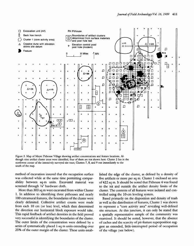
Journal of Field Archaeology/Vol. 16, 1989 411
+ 4- t , O Excavation unit (m2) PH Pithouse o Back hoe trench r Boundaries of artifact clusters + +
Cluster 1 (core activity determined from surface materials ( Cluster 1 (core activity area)
and post hole test and post hole test a Coppice dune with elevation Elevation control post/ above site datum -post hole (modern)
Feature \
0 8 Miles MN PH4
+L1 1
,I
0 P +0
t - + +.1t+
+ + ? + + + 9 4 + +
+ + + + 4 + + + 4 -I::
/-P 1 a L . . J + + + +
+ + + + . .
++ + 4 P %P
4" + + + +
- +
4-++ .
+
-- ! A+ 26 a I9 n s 1ZL
+ + + + +
++ r I4- 4 ?IrP t
,rl 1rl
+ + + +B 4- 4 + + 4 +
+ + +4- - + 4- 4- + 4- + +57
Fea. 12 + + 4- + + + + 4- 4- + 4- + 4- 4 4
+ + -
+ + + + 4- 4 + +
- +
4-- ED
Figure 3. Map of Meyer Pithouse Village showing artifact concentrations and feature locations. Al- though nine artifact cluster areas were identified, four of them are not shown here: Cluster 2 lies in the northwest corner of the intensively surveyed site tract; Clusters 7, 8, and 9 rest immediately to the south of the map.
method of excavation insured that the occupation surface was collected while at the same time permitting compar- ability between sq-m units. Excavated material was screened through /8" hardware cloth.
More than 303 sq m were excavated from within Cluster 1. In addition to identifying three pithouses and nearly 100 extramural features, the boundaries of the cluster were
clearly delimited. Collective artifact counts were made from each 10 cm (or less) level, which then determined the direction our horizontal block exposure would take. This rapid feedback of artifact densities in the field proved very successful in identifying the boundaries of the cluster. The outer limits of the concentration were defined by a series of systematically placed 1-sq m units extending over 25% of the outer margin of the cluster. These units estab-
lished the edge of the cluster, as defined by a density of five artifacts or more per sq m. Cluster 1 enclosed an area of 422 sq m. It should be noted that Pithouse 4 was found to the NE and outside the artifact density limits of the cluster. The contents of all features were isolated and con- trolled using the 10-cm leveling system.
Based primarily on the disposition and density of trash as well as the distribution of features, Cluster 1 was shown to represent a "core activity area" revealing well-defined site structure. At this juncture, it can only be stated that a spatially representative sample of the community was examined. It should be noted, however, that the absence of caches and the scarcity of pit-feature superposition sug- gest an extended, little-interrupted period of occupation of the village (see below).
412 Village ofLate Pithouse-Early Pueblo Period/Scarborough
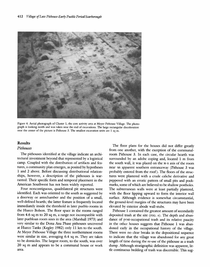
Figure 4. Aerial photograph of Cluster 1, the core activity area at Meyer Pithouse Village. The photo- graph is looking north and was taken near the end of excavations. The large rectangular discoloration near the center of the picture is Pithouse 3. The smallest excavation units are 1 sq m.
Results Pithouses
The pithouses identified at the village indicate an archi- tectural investment beyond that represented by a logistical camp. Coupled with the distribution of artifacts and fea- tures, a community plan emerges, as posited by hypotheses 1 and 2 above. Before discussing distributional relation- ships, however, a description of the pithouses is war- ranted. Their specific form and temporal placement in the American Southwest has not been widely reported.
Four noncontiguous, quadrilateral pit structures were identified. Each was oriented to the south as suggested by a doorway or antechamber and the position of a small, well-defined hearth; the latter feature is frequently located immediately inside the threshold in later pueblo rooms in the Hueco Bolson. The floor space in the rooms ranged from 4.6 sq m to 20 sq m, a range not incompatible with later puebloan room sizes in the area (Marshall 1973) and very similar to the Dona Ana Phase pithouses uncovered at Hueco Tanks (Kegley 1982) only 11 km to the south. At Meyer Pithouse Village the three northernmost rooms were similar in size, averaging 6.4 sq m. They are taken to be domiciles. The largest room, to the south, was over 20 sq m and appears to be a communal house or work area.
The floor plans for the houses did not differ greatly from one another, with the exception of the communal- room Pithouse 3. In each case, the circular hearth was surrounded by an adobe coping and, located 1 m from the south wall, it was placed on the N-s axis of the room near an apparent southern entranceway (Pithouse 3 was probably entered from the roof). The floors of the struc- tures were plastered with a crude caliche derivative and peppered with an erratic pattern of small pits and pock- marks, some of which are believed to be shallow postholes. The subterranean walls were at least partially plastered, with the floor lipping upward to form the interior wall surface. Although evidence is somewhat circumstantial, the ground-level margins of the structures may have been elevated by exterior abode wall-stubs.
Pithouse 1 contained the greatest amount of secondarily deposited trash at the site (FIG. 6). The depth and abun- dance of post-occupational trash and its relative paucity in the other houses suggests that Pithouse 1 was aban- doned early in the occupational history of the village. There were no clear breaks in the depositional sequence to indicate that the village was abandoned for any great length of time during the re-use of the pithouse as a trash dump. Although stratigraphic definition was apparent, lit- tle continuous bedding of trash was discernible. This sug-
Journal of Field Archaeology/Vol. 16, 1989 413
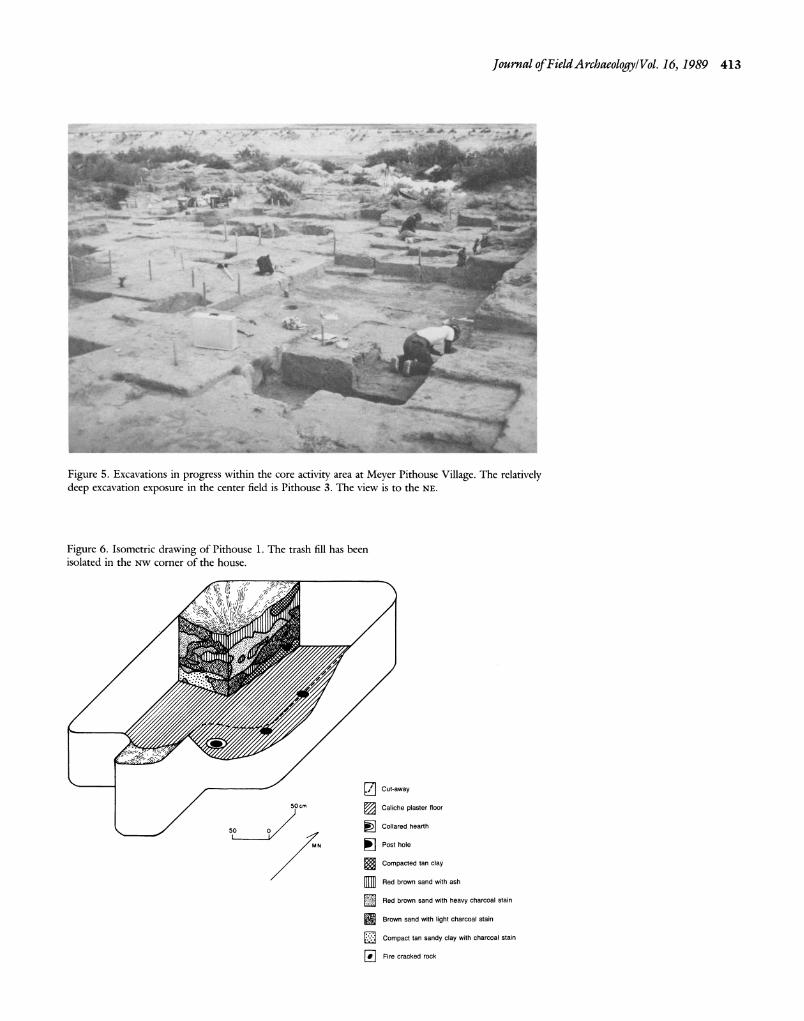
Figure 5. Excavations in progress within the core activity area at Meyer Pithouse Village. The relatively deep excavation exposure in the center field is Pithouse 3. The view is to the NE.
Figure 6. Isometric drawing of Pithouse 1. The trash fill has been isolated in the Nw corner of the house.
Cut-away 50cm C Caliche plaster floor
50 O0 -
Collared hearth
MN Post hole
Compacted tan clay
Red brown sand with ash
Red brown sand with heavy charcoal stain
Brown sand with light charcoal stain
Compact tan sandy clay with charcoal stain
] Fire cracked rock
414 Village ofLate Pithouse-Early Pueblo Period/Scarborough
gests that isolated but repeated dumping events were re-
sponsible for the appearance of the fill. Pithouse 2 contained 60% less trash by volume than
Pithouse 1, while both Pithouses 3 (the communal room) and Pithouse 4 were infilled with less than 10% as much trash by volume as Pithouse 1. Except for the working- floor surface of the communal room, the remaining pit- house floors were devoid of artifacts. Only Structure 5, a
saucer-shaped floor area believed to be the remains of an
ephemeral hut, contained a comparable amount of floor debris to that reported in the communal room.
The formal evidence supporting the argument that Pit- house 3 was a communal structure is grounded on four considerations. 1) The size of the room is three times
larger than that of the other domiciles and was able to accommodate a group larger than the nuclear family. 2) The structure indicates a more complex array of activities than the other houses. Over 20 features and numerous artifacts have been defined on the floor, suggesting a broad
range of activities performed during construction and use. Most of the turquoise and obsidian obtained from the site was collected from this context, and the only interment at the site was located in this room. 3) The architectural form of the structure is different from the other dwellings. No molded pot-rest was found in association with the hearth, as in the domiciles. Further, the presence of a deflector shield and possible ventilator, as well as the sug- gestion that the structure was entered by way of the ceiling (a well-defined, diagonally-oriented pair of postholes may in fact be a ladder impression), indicate greater planning than suggested elsewhere. The other three pithouses are much more similar to one another than to Pithouse 3. 4) The structure was more solidly built than the other dwell-
ings. This is indicated by the substantial deposit of wind blown sand resting on the floor and below the mottled matrix thought to represent final roof collapse. Similar
deposits of sterile sands do not appear on the floors of the other houses at the village. To suggest that roofing and support posts for Pithouse 3 remained secure some time after the collapse of the smaller and more easily maintained houses suggests greater energy investment in the construction of the larger room.
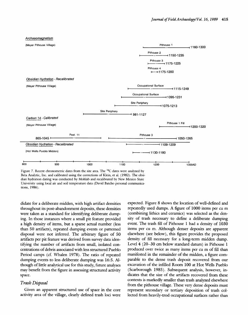
Figure 7 presents the suites of dates associated with the Meyer Pithouse Village. In addition to extramural asso- ciations, each pithouse was dated from its internal hearth by archaeomagnetism (Eighmy 1980). These latter dates are accepted as our most precise chronometric control, each temporal span defined at the 95% confidence interval. The 14C sample taken from the fill of Feature 11, a large trash pit, yielded too early a date to accurately reflect the actual age of the deposit; an "old wood" problem may
account for this aberrant date (Schiffer 1986). A number of large El Paso Polychrome sherds (cross-dated to a pe- riod dated A.c. 1100-1400) were collected from this con- text.
The Hot Wells Pueblo obsidian hydration dates are
presented to emphasize the architectural transition within the research area. The dates were taken on specimens from a midden exposure within a room-block in the northern sector of that site and reveal an age coeval with those
reported for Meyer Pithouse Village. The pueblo dates are earlier than the archaeomagnetic dates reported by Brook (1970, 1975b) for the southern and western por- tions of the site. This circumstance is not surprising given the size of the pueblo and the probable number of build-
ing phases. To summarize, the population of Meyer Pithouse Vil-
lage was clearly small, especially when compared to neigh- boring Hot Wells Pueblo. Although four pithouses and one possible hut were identified, only two of the domiciles can be argued to have been occupied at the same time
(see below). The absolute dating techniques indicate that the site was occupied relatively intensively for a short
period of time. By reviewing the sequence of trash de-
position in Pithouse 1 and observing the lack of trash in other structures, however, more precise ideas of house use and abandonment sequences have been developed. The
greater distribution of artifacts across the core activity area will further indicate a patterned disposal of artifacts in accordance with hypotheses 1 and 2.
Feature Use The reconstruction of the feature-fill sequence is pred-
icated on one assumption, namely that village occupants utilized some patterning in trash disposal. An abandoned
pithouse would be a convenient dumping receptacle for most household trash. Although any depression such as a
depleted storage pit could be used as a garbage container, a pithouse had the clear advantage of holding a large volume of waste at one location. Thus, once any pit was no longer used for its original purpose it was available
immediately for trash disposal. Trash, as defined by larger-sized artifacts found in
greater densities than identified elsewhere, was restricted to pit depressions at Meyer Pithouse Village. Artifact cat- egories included lithic debris (both tools and debitage), sherds, bone, and fire-cracked rock. The last two categories were quantified by weight, the former two by individual counts. Lithic debris and sherd counts, however, were the recognized artifacts or items used in the analysis, as bone and fire-cracked rock were not always present in trash deposits. Because the fill of Pithouse 1 was the best can-
Journal of FieldArchaeology/Vol. 16, 1989 415
Archaeomagnetism
(Meyer Pithouse Village) Pithouse 1 . - 11160-1300
Pithouse 2 ----- 1150-1235
Pithouse 3 S--- 1175-1225
Pithouse 4 *--1175-1200
Obsidian Hydration - Recalibrated
(Meyer Pithouse Village) Occupational Surface I- - 1115-1249
Occupational Surface * -11095-1231
Site Periphery * - 1075-1213
Site Periphery ? I981-1127
Carbon 14 - Calibrated
(Meyer Pithouse Village) Pithouse 1 Fill ~------?-~---120120-320
Feat. 11 Pithouse 3 865-1045 1 1050-1265
Obsidian Hydration - Recalibrated 1- -I 1109-1209
(Hot Wells Pueblo Midden) I *----- 1130-1180
800 900I I I I I I 1300AD
800 900 1000 1100 1200 1300AD
Figure 7. Recent chronometric dates from the site area. The '4C dates were analyzed by Beta Analytic, Inc. and calibrated using the corrections of Klein, et al. (1982). The obsi- dian hydration dating was conducted by Mohlab and recalibrated by New Mexico State
University using local air and soil temperature data (David Batcho personal communica- tions, 1986).
didate for a deliberate midden, with high artifact densities
throughout its post-abandonment deposits, these densities were taken as a standard for identifying deliberate dump- ing. In those instances where a small pit feature provided a high density of items, but a sparse actual number (less than 50 artifacts), repeated dumping events or patterned disposal were not inferred. The arbitrary figure of 50 artifacts per pit feature was derived from survey data iden-
tifying the number of artifacts from small, isolated con- centrations of debris associated with less structured Pueblo Period camps (cf. Whalen 1978). The ratio of repeated dumping events to less deliberate dumping was 16:5. Al- though of little analytical use for this study, future analyses may benefit from the figure in assessing structured activity space.
Trash Disposal Given an apparent structured use of space in the core
activity area of the village, clearly defined trash loci were
expected. Figure 8 shows the location of well-defined and
repeatedly used dumps. A figure of 1000 items per cu m
(combining lithics and ceramics) was selected as the den- sity of trash necessary to define a deliberate dumping event. The trash fill of Pithouse 1 had a density of 1030 items per cu m. Although denser deposits are apparent elsewhere (see below), this figure provides the proposed density of fill necessary for a long-term midden dump. Level 4 (20-30 cm below standard datum) in Pithouse 1 produced over twice as many items per cu m of fill than manifested in the remainder of the midden, a figure com- parable to the dense trash deposit recovered from our excavation of the infilled Room 100 at Hot Wells Pueblo (Scarborough 1985). Subsequent analysis, however, in- dicates that the size of the artifacts recovered from these contexts is markedly smaller than trash analyzed elsewhere from the pithouse village. These very dense deposits must represent secondary or tertiary deposition of trash col- lected from heavily-trod occupational surfaces rather than
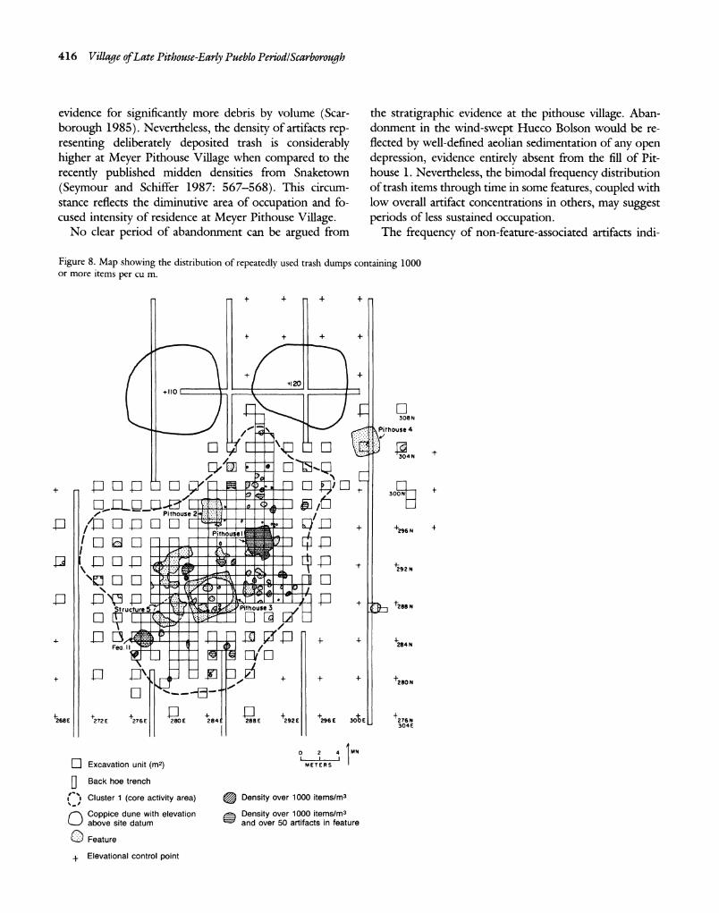
416 Village ofLate Pithouse-Early Pueblo Period/Scarborough
evidence for significantly more debris by volume (Scar- borough 1985). Nevertheless, the density of artifacts rep- resenting deliberately deposited trash is considerably higher at Meyer Pithouse Village when compared to the
recently published midden densities from Snaketown
(Seymour and Schiffer 1987: 567-568). This circum- stance reflects the diminutive area of occupation and fo- cused intensity of residence at Meyer Pithouse Village.
No clear period of abandonment can be argued from
the stratigraphic evidence at the pithouse village. Aban- donment in the wind-swept Hueco Bolson would be re- flected by well-defined aeolian sedimentation of any open depression, evidence entirely absent from the fill of Pit- house 1. Nevertheless, the bimodal frequency distribution of trash items through time in some features, coupled with low overall artifact concentrations in others, may suggest periods of less sustained occupation.
The frequency of non-feature-associated artifacts indi-
Figure 8. Map showing the distribution of repeatedly used trash dumps containing 1000 or more items per cu m.
+ + + +
- + + +
+120 +110o
308N
1 Pithouse 4
-P E ,l Poo,
R % ,
F1 El E 304N
- Pithouse 2.~fii: 1EE-1
El-F-I IE,
+296N, LPithouse I " ] .
/ +2809 N
268E 272E 276E E 284 8E 292E 296E 3E +2N FaII 0 2 4 4MNN
-Excavation unit (m2) METRS U Back hoe trench
("> Cluster 1 (core activity area) @ Density over 1000 items/m3 O Coppice dune with elevation Density over 1000 items/m3 above site datum
w and over 50 artifacts in feature
O Feature 4 Elevational control point
+ Elevational control point
Journal of FieldArchaeology/Vol. 16, 1989 417
cates a ratio of sherds to lithics of slightly greater than
1:2, a figure comparable to that for most of the feature fill. The similarity of the proportions suggests that the core area was the surface upon which most activity oc- curred. Debris is believed to have been swept or removed
periodically from the surface of the core area and rede-
posited in trash pits. Such an expectation follows from extended occupation at a site (hypothesis 2). Although nearly half of the total artifact inventory was collected
from non-feature localities, most of these objects were
extremely small and were likely found in the context of
original breakage, and were not redeposited (see below).
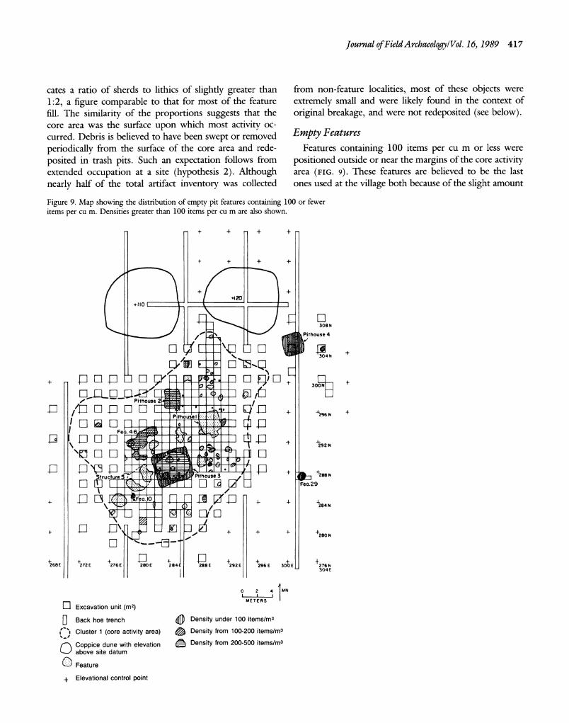
Empty Features Features containing 100 items per cu m or less were
positioned outside or near the margins of the core activity area (FIG. 9). These features are believed to be the last ones used at the village both because of the slight amount
Figure 9. Map showing the distribution of empty pit features containing 100 or fewer items per cu m. Densities greater than 100 items per cu m are also shown.
- + - + +
+ + + +
+ 4- +120
+110 1
308 N
IVA Pifhouse 4
S- Pithouse 2I
hPithousie t u d 296 N
Fe. 46
' C 1 a t1 ite292sN
TI,
.•
+ t288 N
tioolo84 N
4O-r + + + +2280 N
4268E +272 E +276 E 280E 284 288 E 292E 296E 300E 276N 304 E O 2 4 MN
r- Excavation unit (m2) METERS
0 Back hoe trench Density under 100 items/ma
~" Cluster 1 (core activity area) Density from 100-200 items/m3
SCoppice dune with elevation Density from 200-500 items/ms above site datum
U Feature
+ Elevational control point
418 Village ofLate Pithouse-Early Pueblo Period/Scarborough
of debris in them and because of the previously mentioned
pattern of utilizing empty pits. The few artifacts retrieved from these contexts are construed to be items that have fallen in from the margins of the pit feature. Pithouse 4 and Pithouse 3 (the communal room) were the last two structures used, as indicated by the absence of trash-fill items. The period associated with the empty pit features
immediately prior to the final abandonment of the site
may represent the approximate number of storage pits excavated and in use by the occupants of Pithouse 4 and the users of Pithouse 3.
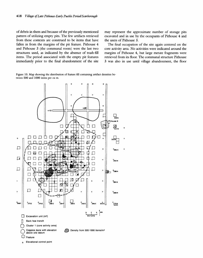
The final occupation of the site again centered on the core activity area. No activities were indicated around the
margins of Pithouse 4, but large metate fragments were retrieved from its floor. The communal structure Pithouse 3 was also in use until village abandonment, the floor
Figure 10. Map showing the distribution of feature fill containing artifact densities be- tween 500 and 1000 items per cu m.
t 4- + +
+ + + +
I+I +110rI
308 N
Pithouse 4
:E 'l 30 4 N
de;sop Pithouse 2 - 300NZ 1 I! D /EPi'0ou + +296 N
+292 N
304El
\0 2 4 EMN
1"] Excavation unit
(m2) METERS /
Structure Pithoumse3288N
SElevational control point + + + +268E +272E 276E 280E 284 288E +292E 296E 300E 276N
304E
0 2 4MN
I Excavation unit (n2) METERS
f Back hoe trench
('I Cluster 1 (core activity area)
Coppice dune with elevation Density from 500-1000 items/n2 above site datum
O Feature
+ Elevational control point
Journal of FieldArchaeology/Vol. 16, 1989 419
littered with lithic debris. Two extramural hearths located in the southern part of the site reveal little reuse as evi- denced by artifact concentrations. Feature 10 to the sw was a shallow, ephemeral feature, while Feature 29 was a substantial roasting pit containing considerable charcoal and ash, but little or no fire-cracked rock. Given the char- acter of agave roasting pits elsewhere in the Hueco Bolson (Hard 1983), the absence of fire-cracked rock makes the function of this feature somewhat enigmatic. Of special note are Feature 46 and Pithouse 2. Both contained 200- 500 items per cu m and were perhaps trash disposal loci late in the occupation of the site. If these features had been used and abandoned early in the occupation of the site, they would be expected to have a more dense con- centration of trash in their fill. The size and central loca- tion of abandoned Pithouse 2 would have made it an
especially attractive dumping site.
Intensive Occupational Zones
Figure 10 illustrates feature-artifact densities greater than 500 items per cu m but less than 1000 items per cu m. It indicates that the density resting in and on the floor of the communal structure Pithouse 3, although substan- tial, was not that of a midden dump. Moreover, it reveals a comparable density of debris lying on the floor of Struc- ture 5 (the hut-like structure). This is an expected rela-
tionship given the work-related activities associated with a ramada (canopied shelter) or hut containing a friable dirt floor. All of these deposits rest squarely within the core activity area.
The Feature Sequence The distribution of trash has revealed significant aspects
of community patterning (Binford 1982). Although a ter- minus ante quem is difficult, a relative post quem is not. Pithouse 1 was abandoned early and used as the central trash receptacle for the small, circumscribed community. Pithouse 2, on the other hand, contained a relatively small amount of trash and appears to have been abandoned sometime near the end of the village occupation. Pithouses 3 and 4 were occupied into the final moments of the community. Structure 5 is somewhat enigmatic given its lack of depth and its questionable utility as a trash recep- tacle and cannot be assigned a relative date of abandon- ment.
The apparent reliability of the archaeomagnetic dating would suggest that the earliest pithouse occupation did not occur before A.c. 1150 (Pithouse 2). Given the se- quence of pithouse abandonment, Pithouse 4 indicates that the last structure was no later than A.c. 1200. Our
best estimate, then, for the occupation span of Meyer Pithouse Village is A.C. 1150-1200.
Trash pits are much more difficult to sequence. Most features indicate that some time elapsed before dumping actually occurred. The distribution of artifact concentra- tions within features, taken from arbitrary 10-cm intervals, indicates that dumping events immediately following the removal of a feature's contents only occurred in 14 of the 68 features reported with artifacts. Although idiosyncratic behavior may account for some of this pattern, it is sug- gested that the site may have been abandoned for a short period following the removal of the contents in these pits, perhaps following the intensive use and infilling of Pit- house 1 with trash.
Non-Feature Artifact Distribution Hypothesis 3, that a patterned area larger than the zone
immediately around a household exists, is supported by the patterned use of space across the principal residential area at Meyer Pithouse Village. Further, hypothesis 4, that an insular house manifests little activity near its margins, is supported by Pithouse 4. In the core area of 422 sq m, the highest density of artifacts and features was identified. Although three pithouse structures were unearthed, Pit- house 4 was found outside and away from these other trash concentrations. This circumstance suggests that a structured cleaning and depositing of collected trash from in and around houses was carried out at Meyer Pithouse Village.
The distributional pattern of artifacts was evaluated from the occupational surface debris. This surface, usually associated with artifact concentrations, was defined by a more compacted, silty loam than identified either above or below it. Generally, the occupational surface sloped gently downward from east to west, representing only a 20 cm drop over a total distance of 35 m within the core activity area. Although feature fill intersected the occupa- tion surface, only that portion of feature fill associated with the occupational surface is examined here.
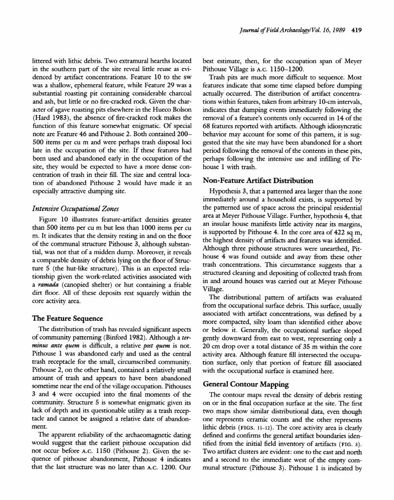
General Contour Mapping The contour maps reveal the density of debris resting
on or in the final occupation surface at the site. The first two maps show similar distributional data, even though one represents ceramic counts and the other represents lithic debris (FIGS. 11-12). The core activity area is clearly defined and confirms the general artifact boundaries iden- tified from the initial field inventory of artifacts (FIG. 3). Two artifact clusters are evident: one to the east and north and a second to the immediate west of the empty com- munal structure (Pithouse 3). Pithouse 1 is indicated by
420 Village ofLate Pithouse-Early Pueblo Period/Scarborough
4 /0
2
o50
.to
00
Scale Explanation 0 3m '
E 36 m ( Structure Contour Interval: 10 Items
Figure 11. Computer-generated artifact-density contour map of all ce- ramics distributed across the occupational surface.
the densest concentration of debris at the site, although surface deposits elsewhere also reveal very high artifact densities. The area immediately north and south of Pit- house 1 shows densities interpreted as reflecting repeated activity use, or dumping associated with the pithouse fill. The western portion of the core activity area indicates
higher-than-anticipated artifact densities given the re- duced number of features identified from this zone. Pit- house 4 lies outside the core activity area.
Given the E-w subdivisioning of the community along the same general, parallel axis as the individual structures, a degree of patterned activity is apparent. The communal
house, Pithouse 3, separates the two halves of the com-
munity with a cleared area, presumed to be a path, running NNw/SSE through the center of the core activity area. The cleared area is best defined to the north and represents swept plaza space. In addition, the area north, west, and south of Pithouse 2 is less cluttered and may represent an
attempt to clear the immediate margins of the house prior to abandonment. This swept space away from the main
plaza zone may be a vestige of the earlier occupation of Pithouse 2. This pithouse, unlike Pithouses 3 and 4, was not occupied at the time of final site abandonment.
Fine-Grained Mapping To further assist our analysis, a spatially-controlled sam-
ple of occupational surface artifacts was examined by item
4
/0 50
90 /00
/0
•,o
tp
Scale Explanation 0 3m
O, ,i3m
Q Structure Contour Interval: 20 Items
Figure 12. Computer-generated artifact-density contour map of all lithics distributed across the occupational surface.
Figure 13. Computer-generated artifact-density contour map of lithic items up to 2 cm (maximum length) distributed across the occupa- tional surface.
4
2
0 3m
Fea 13
Scale Explanation - L 3:Structure
Contour Interval: 20 Items
Journal of FieldArchaeology/Vol. 16, 1989 421
size. Large sherds and lithics were anticipated as being associated with spatially well-defined midden zones, while smaller lithics and sherds were predicted to suggest break-
age locations having experienced heavy foot traffic. The
sample was chosen with reference to the four pithouses and the greater core activity area (FIG. 3). The floors of the houses (including Structure 5) were examined in their
entirety, while within a contiguous area 2m or less outside a house, every other 1-m unit was examined (a 50% sam-
ple). The remainder of the core activity area was studied at 4-m intervals, providing an additional 25% sample.
Features were not the focus of the analysis, except with reference to the residential structures. Nevertheless, the fill of those features encountered by our systematic design was examined, although only the basal 20 cm of fill was re-studied. Feature-fill sherds were consistently larger than those associated with the exposed occupational surface
(Scarborough 1985). In addition, the contents from Fea- ture 13 (an extramural hearth) were analyzed because of the unusually high lithic densities reported and the in-
ability of our 4-m interval sample to encompass them.
Except for the upper levels of Feature 13, these biased feature data do not appear in the contour mapping anal-
ysis.
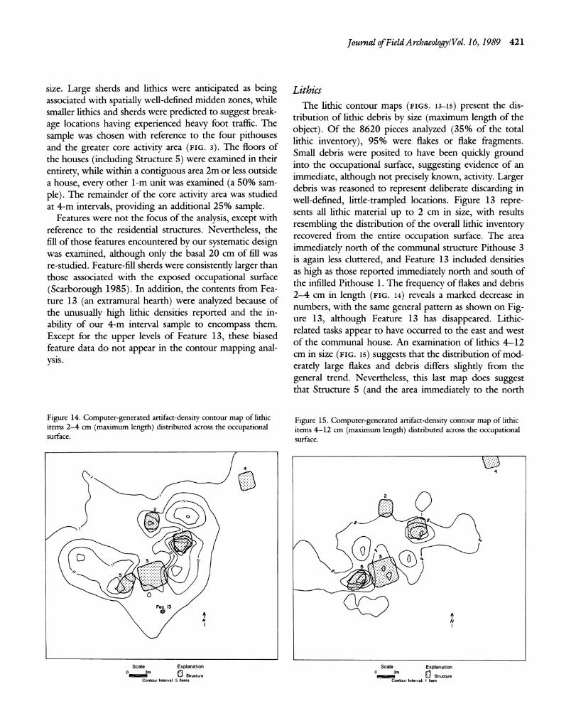
Lithics The lithic contour maps (FIGS. 13-15) present the dis-
tribution of lithic debris by size (maximum length of the
object). Of the 8620 pieces analyzed (35% of the total lithic inventory), 95% were flakes or flake fragments. Small debris were posited to have been quickly ground into the occupational surface, suggesting evidence of an
immediate, although not precisely known, activity. Larger debris was reasoned to represent deliberate discarding in well-defined, little-trampled locations. Figure 13 repre- sents all lithic material up to 2 cm in size, with results
resembling the distribution of the overall lithic inventory recovered from the entire occupation surface. The area
immediately north of the communal structure Pithouse 3 is again less cluttered, and Feature 13 included densities as high as those reported immediately north and south of the infilled Pithouse 1. The frequency of flakes and debris 2-4 cm in length (FIG. 14) reveals a marked decrease in
numbers, with the same general pattern as shown on Fig- ure 13, although Feature 13 has disappeared. Lithic- related tasks appear to have occurred to the east and west of the communal house. An examination of lithics 4-12 cm in size (FIG. 15) suggests that the distribution of mod-
erately large flakes and debris differs slightly from the
general trend. Nevertheless, this last map does suggest that Structure 5 (and the area immediately to the north
Figure 14. Computer-generated artifact-density contour map of lithic items 2-4 cm (maximum length) distributed across the occupational surface.
2Q
Fea. 13
Scale Explanation 0 m
Structure Contour Interval: 5 Items
Figure 15. Computer-generated artifact-density contour map of lithic items 4-12 cm (maximum length) distributed across the occupational surface.
2
N
Scale Explanation 0
3m 1 Structure Contour Interval: 1 Item
422 Village ofLate Pithouse-Early Pueblo Period/Scarborough
of it) may have served on occasion as a discrete trash
depository following its abandonment. The larger size of lithic debris, we believe, indicates the trash-receptacle function of Pithouse 1. Feature 13 does not appear on the contour map in Figure 15, suggesting that only lithic- related tasks (small debris rapidly trodden into the sub-
stratum) occurred in this area, as opposed to deliberate trash disposal.
A further map not provided here was made of the distribution of lithic debris having cortex present. It was
anticipated that if the site had had a specialized lithic
procurement or manufacturing bias, the distribution of
primary and secondary lithic debris would be differentially patterned. This was not the case. A contour plot (not illustrated here) of tertiary flake debris (no cortex) also
proved nearly identical to the total lithic inventory map. Evidence suggests that the pithouse did not have a task-
specific orientation, a corollary of extended residential oc-
cupation (hypothesis 2). Locations of tool manufacture or use were difficult to
determine, but gross activity zones appear to cluster on the east and west sides of the communal house. The con- tour maps reveal a degree of spatial bilateral symmetry with respect to the overall distribution of debris.
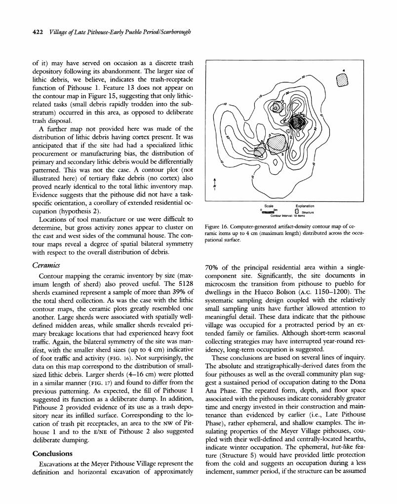
Ceramics Contour mapping the ceramic inventory by size (max-
imum length of sherd) also proved useful. The 5128 sherds examined represent a sample of more than 39% of the total sherd collection. As was the case with the lithic contour maps, the ceramic plots greatly resembled one another. Large sherds were associated with spatially well- defined midden areas, while smaller sherds revealed pri- mary breakage locations that had experienced heavy foot traffic. Again, the bilateral symmetry of the site was man-
ifest, with the smaller sherd sizes (up to 4 cm) indicative of foot traffic and activity (FIG. 16). Not surprisingly, the
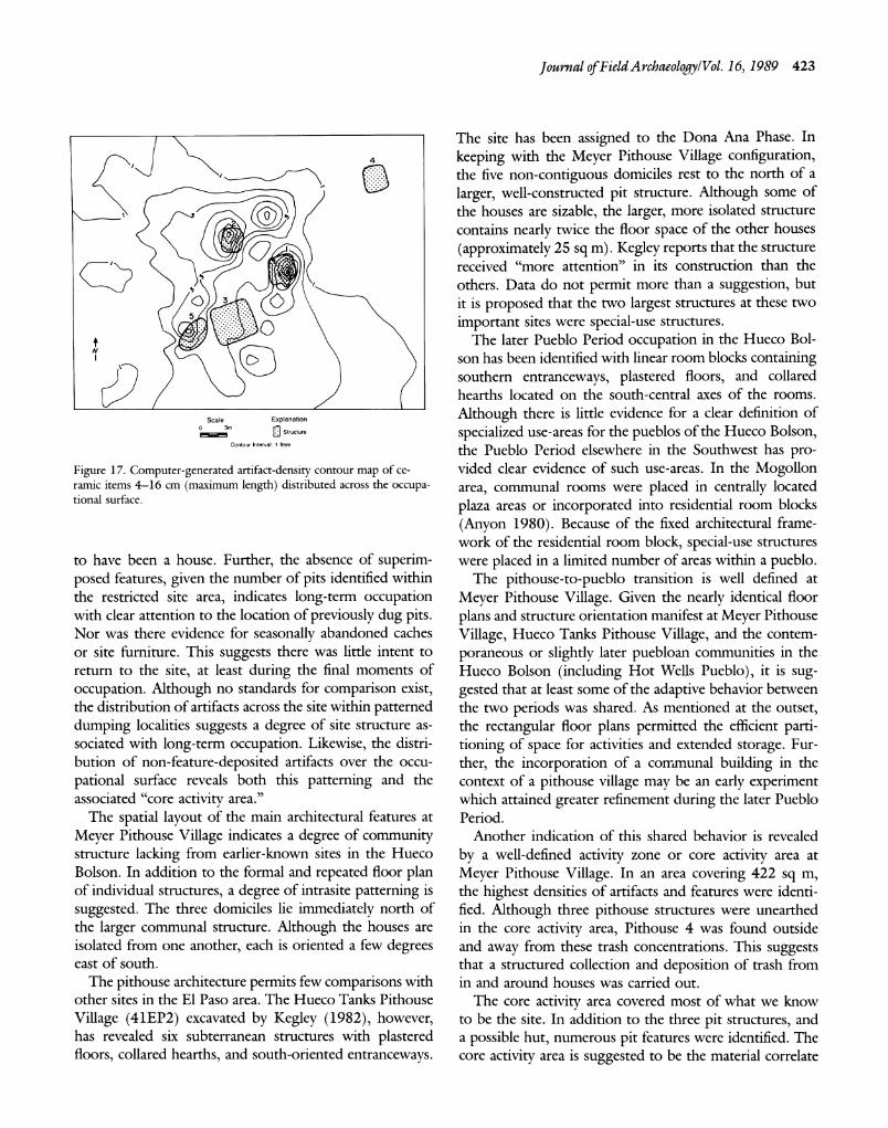
data on this map correspond to the distribution of small- sized lithic debris. Larger sherds (4-16 cm) were plotted in a similar manner (FIG. 17) and found to differ from the
previous patterning. As expected, the fill of Pithouse 1
suggested its function as a deliberate dump. In addition, Pithouse 2 provided evidence of its use as a trash depo- sitory near its infilled surface. Corresponding to the lo- cation of trash pit receptacles, an area to the Nw of Pit- house 1 and to the E/NE of Pithouse 2 also suggested deliberate dumping.
Conclusions
Excavations at the Meyer Pithouse Village represent the definition and horizontal excavation of approximately
4 10
S30 NO 2
Scale Explanation
o• •2" 3~Structure Contour Interval: 10 Items
Figure 16. Computer-generated artifact-density contour map of ce- ramic items up to 4 cm (maximum length) distributed across the occu- pational surface.
70% of the principal residential area within a single- component site. Significantly, the site documents in microcosm the transition from pithouse to pueblo for
dwellings in the Hueco Bolson (A.c. 1150-1200). The
systematic sampling design coupled with the relatively small sampling units have further 'allowed attention to
meaningful detail. These data indicate that the pithouse village was occupied for a protracted period by an ex- tended family or families. Although short-term seasonal
collecting strategies may have interrupted year-round res-
idency, long-term occupation is suggested. These conclusions are based on several lines of inquiry.
The absolute and stratigraphically-derived dates from the four pithouses as well as the overall community plan sug- gest a sustained period of occupation dating to the Dona Ana Phase. The repeated form, depth, and floor space associated with the pithouses indicate considerably greater time and energy invested in their construction and main- tenance than evidenced by earlier (i.e., Late Pithouse
Phase), rather ephemeral, and shallow examples. The in-
sulating properties of the Meyer Village pithouses, cou-
pled with their well-defined and centrally-located hearths, indicate winter occupation. The ephemeral, hut-like fea- ture (Structure 5) would have provided little protection from the cold and suggests an occupation during a less inclement, summer period, if the structure can be assumed
Journal of FieldArchaeology/Vol. 16, 1989 423
4+
I. O0
Scale Explanation 0
3m Structure
Contour Interval: 1 Item
Figure 17. Computer-generated artifact-density contour map of ce- ramic items 4-16 cm (maximum length) distributed across the occupa- tional surface.
to have been a house. Further, the absence of superim- posed features, given the number of pits identified within the restricted site area, indicates long-term occupation with clear attention to the location of previously dug pits. Nor was there evidence for seasonally abandoned caches or site furniture. This suggests there was little intent to return to the site, at least during the final moments of
occupation. Although no standards for comparison exist, the distribution of artifacts across the site within patterned dumping localities suggests a degree of site structure as- sociated with long-term occupation. Likewise, the distri- bution of non-feature-deposited artifacts over the occu-
pational surface reveals both this patterning and the associated "core activity area."
The spatial layout of the main architectural features at
Meyer Pithouse Village indicates a degree of community structure lacking from earlier-known sites in the Hueco Bolson. In addition to the formal and repeated floor plan of individual structures, a degree of intrasite patterning is
suggested. The three domiciles lie immediately north of the larger communal structure. Although the houses are isolated from one another, each is oriented a few degrees east of south.
The pithouse architecture permits few comparisons with other sites in the El Paso area. The Hueco Tanks Pithouse
Village (41EP2) excavated by Kegley (1982), however, has revealed six subterranean structures with plastered floors, collared hearths, and south-oriented entranceways.
The site has been assigned to the Dona Ana Phase. In
keeping with the Meyer Pithouse Village configuration, the five non-contiguous domiciles rest to the north of a
larger, well-constructed pit structure. Although some of the houses are sizable, the larger, more isolated structure contains nearly twice the floor space of the other houses
(approximately 25 sq m). Kegley reports that the structure received "more attention" in its construction than the others. Data do not permit more than a suggestion, but it is proposed that the two largest structures at these two
important sites were special-use structures. The later Pueblo Period occupation in the Hueco Bol-
son has been identified with linear room blocks containing southern entranceways, plastered floors, and collared hearths located on the south-central axes of the rooms.
Although there is little evidence for a clear definition of
specialized use-areas for the pueblos of the Hueco Bolson, the Pueblo Period elsewhere in the Southwest has pro- vided clear evidence of such use-areas. In the Mogollon area, communal rooms were placed in centrally located
plaza areas or incorporated into residential room blocks
(Anyon 1980). Because of the fixed architectural frame- work of the residential room block, special-use structures were placed in a limited number of areas within a pueblo.
The pithouse-to-pueblo transition is well defined at
Meyer Pithouse Village. Given the nearly identical floor
plans and structure orientation manifest at Meyer Pithouse
Village, Hueco Tanks Pithouse Village, and the contem-
poraneous or slightly later puebloan communities in the Hueco Bolson (including Hot Wells Pueblo), it is sug- gested that at least some of the adaptive behavior between the two periods was shared. As mentioned at the outset, the rectangular floor plans permitted the efficient parti- tioning of space for activities and extended storage. Fur- ther, the incorporation of a corrmnunal building in the context of a pithouse village may be an early experiment which attained greater refinement during the later Pueblo Period.
Another indication of this shared behavior is revealed
by a well-defined activity zone or core activity area at
Meyer Pithouse Village. In an area covering 422 sq m, the highest densities of artifacts and features were identi- fied. Although three pithouse structures were unearthed in the core activity area, Pithouse 4 was found outside and away from these trash concentrations. This suggests that a structured collection and deposition of trash from in and around houses was carried out.
The core activity area covered most of what we know to be the site. In addition to the three pit structures, and a possible hut, numerous pit features were identified. The core activity area is suggested to be the material correlate
424 Village ofLate Pithouse-Early Pueblo Period/Scarborough
of the cooperative work unit within the village. It may be that the early abandonment of Pithouse 1 attracted daily activities to this ready-made trash receptacle. It should be noted that over 15% of the lithics and nearly 20% of the sherds from the entire excavation sample were recovered from this pithouse. The rapid removal of spent artifacts and organic by-products from the site facilitated the do- mestic routine. The core activity area can be viewed as a zone set aside for structured communal activities. In more
complex communities, centralized work areas can be ex-
pected. The nuclear family or the occupants of the limited floor space within a pithouse, are not viewed as the small- est social division during the transition to puebloan life
(cf. Netting, Wilk, and Arnould 1984). Although the nuclear family or the immediate household might be the smallest unit of analysis for earlier times, by the Dona Ana Phase these analytical units appear to bond with like households. Household trash deposits and activity space at this site suggest more structured cooperation than in
previous periods. Community structure is most clearly identifiable during the subsequent Pueblo Period with the
appearance of shared plaza space, milling rooms, storage rooms, and communal activity areas as evidenced in ad-
jacent regions of the puebloan Southwest.
Acknowledgments I thank Michael Blake, Glen DeGarmo, Creighton Ga-
bel, Rex Gerald, Robert Hard, Raymond Mauldin, Mi- chael Schiffer, Alan Sullivan, Grace H. Ziesing, and Al
Wesolowsky for their suggestions and support. Paul Lu-
kowski, Chuck Haight, Lisa LeCount, Lisa Esile, and Tim Graves provided field assistance. Brigid Sullivan and Linda Marston prepared the illustrations. Sandi Cannell typed the manuscript. Financial support was given by the United States Army and Fort Bliss, Texas, as well as the Office of the Dean, College of Arts and Sciences, University of Cincinnati. The Environmental Protection Office at Fort
Bliss supervised the project.
Vernon L. Scarborough was director of the Meyer Pithouse Village Project at Fort Bliss. He has worked in the western United States, Belize, Sudan, and Pakistan. His topical inter- ests remain settlement patterns/architecture and water man- agement. Currently he isAssistant Professor in the Depart- ment ofAnthropology, Mail Location 380, University of Cincinnati, Cincinnati OH 45221.
Anyon, Roger 1980 "The Architectural Evolution of Mogollon-Mimbres Cer-
emonial Structures," The Kiva 45: 253-277.
Beckes, Michael R., David S. Dibble, and Martha D. Freeman 1977 A Cultural Resource Inventory and Assessment of McGregor
Guided Missile Range: Otero County, New Mexico, Part 1. Texas Archaeological Survey Research Report No. 6511. Austin: University of Texas.
Binford, Lewis R. 1982 'The Archaeology of Place," Journal of Anthropological
Archaeology 1: 5-31.
Brook, Vernon R. 1970 "Four Archaeomagnetic Dates from the Hot Wells Site
(EPAS-3)," The Artifact 8: 1-16.
1975a Cultural Traits of the El Paso Phase of the Mogollon. Hobbs, New Mexico: Lea County Archaeological Society.
1975b 'The Development of Prehistoric House Types in the Jornada Branch," Awanyu 3: 16-31.
Carmichael, David L. 1981 "Non-residential Occupation of the Prehistoric Southern
Tularosa Basin, New Mexico," in M. S. Foster, ed., Ar- chaeological Essays in Honor ofMark Wimberly. TheArtifact 19 (3 and 4): 51-68. El Paso Archaeological Society.
1985a "Pithouse to Pueblo Transition in the Jornada Mogollon: A Reappraisal," in M. S. Foster and T. C. O'Laughlin, eds., Proceedings of the ThirdJornada-Mogollon Conference. The Artifact 23 (1 and 2): 109-118. El Paso Archaeo- logical Society.
1985b Archaeological Excavations at Two Prehistoric Campsites near Keystone Dam, El Paso, Texas. University Museum Occasional Papers 14. Las Cruces: New Mexico State Uni- versity.
1986 Archaeological Survey in the Southern Tularosa Basin ofNew Mexico. Historic and Natural Resources Report 3. Fort Bliss: Environmental Management Office, United States Army Air Defense Artillery Center.
Cordell, Linda 1984 Prehistory of the Southwest. Orlando: Academic Press.
Eighmy, Jeffrey L. 1980 Archaeomagnetism: A Handbook for the Archaeologist. Her-
itage Conservation and Recreation Service, Publication No. 58. Washington, D.C.: United States Department of the Interior.
Flannery, Kent V. 1972 'The Origins of the Village as a Settlement Type in
Mesoamerica and the Near East: A Comparative Study," in Peter J. Ucko, Ruth Tringham, and G. W. Dimbleby, eds., Man, Settlement and Urbanism. London: Duck- worth, 23-53.
Gilman, Patricia A. 1987 "Architecture as Artifact: Pit Structures and Pueblos in
the American Southwest," American Antiquity 52: 538- 564.
Hard, Robert J. 1983 Excavations in the Castner Range Archaeological District in
El Paso, Texas. El Paso Centennial Museum Publications in Anthropology 11. El Paso: University of Texas at El Paso.
Hedrick, John A. 1967 "Escondido Survey," The Artifact 5(1): 19-34.
Journal ofFieldArchaeology/Vol. 16, 1989 425
Hubbard, Richard A. 1987 "Prehistoric Agricultural Fields and Water Control Sys-
tems of South-Central New Mexico," unpublished M.A. thesis, Department of Anthropology, University of Texas, Austin.
Hunter-Anderson, Rosalind L. 1977 "A Theoretical Approach to the Study of House Form,"
in Lewis R. Binford, ed., For Theory Building in Archae- ology. New York: Academic Press, 287-316.
Kauffman, Barbara, and David Batcho 1983 "Ephemeral Sites and Resilient Folk: A Discussion and
Analysis of Seven Archaeological Sites Near Las Cruces, New Mexico," U.S.D.A. Forest Service report on file with the Cultural Resources Management Division, New Mexico State University, Las Cruces.
Kegley, George 1982 Archaeological Investigations at Hueco Tanks State Historical
Park, El Paso County, Texas. Austin: Texas Parks and Wildlife Department.
Klein, Jeffery, J. C. Lerman, P. E. Damon, and E. K. Ralph 1982 "Calibration of Radiocarbon Dates," Radiocarbon 24:
103-150.
Lehmer, Donald J. 1948 The Jornada Branch of the Mogollon. University ofArizona
Social Science Bulletin 17. Tucson.
Lipe, William D., and Cory D. Breternitz 1980 "Approaches to Analyzing Variability among Dolores
Area Structures, A.D. 600-900," Contract Abstracts and CRMArchaeology 1(2): 21-28.
McGuire, Randall H., and Michael B. Schiffer 1983 "A Theory of Architectural Design," Journal of Anthro-
pological Archaeology 3: 277-303.
Marshall, Michael P. 1973 "Background Information on the Jornada Culture Area,"
in Technical Manual: 1973 Survey of the Tularosa Basin, the Research Design. Albuquerque: Human Systems Re- search, 49-120.
Martin, Paul S. and Fred Plog 1973 The Archaeology ofArizona. New York: Doubleday.
Netting, Robert M., Richard R. Wilk, and Eric J. Arnould, eds. 1984 Households: Comparative and Historical Studies of the Do-
mestic Group. Berkeley: University of California Press.
Plog, Fred 1974 The Study of Prehistoric Change. New York: Academic
Press.
Reed, Paul F. 1987 "Reinterpreting Jornada Mogollon Prehistory," North
American Archaeologist 8: 193-208.
Robbins, Michael C. 1966 "House Types and Settlement Patterns: An Application
of Ethnology to Archaeological Interpretation," Minne- sota Archaeologist 28: 3-26.
Scarborough, Vernon L. 1985 "Meyer Pithouse Village," unpublished manuscript on
file with Environmental Management Office, Fort Bliss, Texas.
1986 "Meyer Pithouse Village: A Preliminary Assessment," in C. Benson and Steadman Upham, eds., Mogollon Varia- bility. Occasional Papers of the University Museum No. 15. Las Cruces: New Mexico State University, 271-284.
1988 "A Water Storage Adaptation in the American South- west," Journal ofAnthropological Research 44: 21-40.
Schiffer, Michael B. 1983 'Toward the Identification of Formation Processes,"
American Antiquity 48: 675-706.
1986 "Radiocarbon Dating and the 'Old Wood' Problem: The Case of the Hohokam Chronology," Journal ofArchaeo- logical Science 13: 13-30.
1987 Formation Processes of the Archaeological Record. Albuquer- que: University of New Mexico Press.
Seymour, Denise J., and Michael B. Schiffer 1987 "A Preliminary Analysis of Pithouse Assemblages from
Snaketown Arizona," in Susan Kent, ed., Method and Theory for Activity Area Research: An Ethnoarchaeological Approach. New York: Columbia University Press, 549- 603.
Shafer, Harry J., and Anne J. Taylor 1986 "Mimbres Mogollon Pueblo Dynamics and Ceramic
Style Changes," Journal of Field Archaeology 13: 43-68.
Upham, Steadman 1984 "Adaptive Diversity and Southwestern Abandonment,"
Journal ofAnthropological Research 40: 235-256.
Whalen, Michael E. 1977 Settlement Patterns of the Eastern Hueco Bolson. El Paso
Centennial Museum Publications in Anthropology 4. El Paso: University of Texas at El Paso.
1978 Settlement Patterns of the Western Hueco Bolson. El Paso Centennial Museum Publications in Anthropology 6. El Paso: University of Texas at El Paso.
1980 Special Studies in the Archaeology of the Hueco Bolson. El Paso Centennial Museum Publications in Anthropology 9. El Paso: University of Texas at El Paso.
1981a "Cultural-Ecological Aspects of the Pithouse-to-Pueblo Transition in a Portion of the Southwest," American Antiquity 46: 75-92.
1981b "An Investigation of Pithouse Village Structure in West- ern Texas," Journal of Field Archaeology 8: 303-311.
1986 "Small-Site Analysis in the Hueco Bolson of Western Texas," Journal of Field Archaeology 13: 69-82.
Whiting, John W., and Barbara Ayres 1968 "Inferences from the Shape of Dwellings," in K. C.
Chang, ed., Settlement Archaeology. Palo Alto: National Press Books, 117-133.