Embed Size (px)
Citation preview
�������� ����� ��
Danube loess stratigraphy – Towards a pan-European loess stratigraphic model
Slobodan B. Markovic, Thomas Stevens, George J. Kukla, Ulrich Ham-bach, Kathryn E. Fitzsimmons, Phil Gibbard, Bjorn Buggle, Michael Zech,Zhengtang Guo, Qingzhen Hao, Haibin Wu, Ken O’Hara Dhand, Ian J.Smalley, Gabor Ujvari, Pal Sumegi, Alida Timar-Gabor, Daniel Veres, FrankSirocko, Djordjije A. Vasiljevic, Zdzisław Jary, Anderss Svensson, VidojkoJovic, Frank Lehmkuhl, Janos Kovacs, Zorica Svircev
PII: S0012-8252(15)30007-6DOI: doi: 10.1016/j.earscirev.2015.06.005Reference: EARTH 2130
To appear in: Earth Science Reviews
Received date: 12 July 2014Revised date: 13 June 2015Accepted date: 19 June 2015
Please cite this article as: Markovic, Slobodan B., Stevens, Thomas, Kukla, GeorgeJ., Hambach, Ulrich, Fitzsimmons, Kathryn E., Gibbard, Phil, Buggle, Bjorn, Zech,Michael, Guo, Zhengtang, Hao, Qingzhen, Wu, Haibin, Dhand, Ken O’Hara, Smal-ley, Ian J., Ujvari, Gabor, Sumegi, Pal, Timar-Gabor, Alida, Veres, Daniel, Sirocko,Frank, Vasiljevic, Djordjije A., Jary, Zdzis�law, Svensson, Anderss, Jovic, Vidojko,Lehmkuhl, Frank, Kovacs, Janos, Svircev, Zorica, Danube loess stratigraphy – To-wards a pan-European loess stratigraphic model, Earth Science Reviews (2015), doi:10.1016/j.earscirev.2015.06.005
This is a PDF file of an unedited manuscript that has been accepted for publication.As a service to our customers we are providing this early version of the manuscript.The manuscript will undergo copyediting, typesetting, and review of the resulting proofbefore it is published in its final form. Please note that during the production processerrors may be discovered which could affect the content, and all legal disclaimers thatapply to the journal pertain.
ACC
EPTE
D M
ANU
SCR
IPT
ACCEPTED MANUSCRIPT
1
Danube loess stratigraphy –towards a pan-European loess
stratigraphic model
Slobodan B. Marković *(1), Thomas Stevens (2), George J. Kukla† (3), Ulrich Hambach (4),
Kathryn E. Fitzsimmons (5), Phil Gibbard (6), Björn Buggle (4, 7), Michael Zech (4,8), Zhengtang
Guo (9), Qingzhen Hao (9), Haibin Wu (9), Ken O'Hara Dhand (10), Ian J. Smalley (10), Gábor
Újvári (11), Pál Sümegi (12), Alida Timar-Gabor (13), Daniel Veres (13, 14), Frank Sirocko (15),
Djordjije A. Vasiljević (16), Zdzisław Jary (17), Anderss Svensson (18), Vidojko Jović (19), Frank
Lehmkuhl (20), János Kovács (21), Zorica Svirčev (1)
(1) Laboratory for Palaeoenvironmental Reconstruction, Faculty of Sciences, University of Novi Sad, Trg Dositeja
Obradovića 2, 21000 Novi Sad, Serbia; * corresponding author [email protected]
(2) Department of Earth Sciences, Uppsala University, Villavägen 16, 75236 Uppsala, Sweden
(3) Lamont-Doherty Earth Observatory of Columbia University, Rt. 9W, Palisades NY10964, USA
(4) BayCEER &Chair of Geomorphology, University of Bayreuth, D-95440 Bayreuth, Germany
(5) Department of Human Evolution, Max Planck Institute for Evolutionary Anthropology, Deutscher Platz 6, D-04103
Leipzig, Germany
(6) Cambridge Quaternary, Department of Geography,University of Cambridge, Downing Place
Cambridge CB2 3EN, England, UK
(7) Geological Institute, ETH Zürich, Sonneggstr. 5, 8092 Zürich, Switzerland.
(8) Soil Physics Department, University of Bayreuth, D-95440 Bayreuth, Germany
(9) Key laboratory of Cenozoic Geology and Environment, Institute of Geology and Geophysics, Chinese Academy of
Sciences, Beijing 10029, China
(10) Giotto Loess Research Group, Geography Department, Leicester University, LeicesterLE1 7RH, UK
(11) Geodetic and Geophysical Research Institute of the Hungarian Academy of Sciences, Csatkai Endre u. 6-8., H-9400
Sopron, Hungary
(12) Department of Geology and Palaeontology, University of Szeged, Egyetem u. 2-6, H-6722 Szeged, Hungary
(13) Faculty of Environmental Science, Babes-Bolyai University, Fantanele, 30, 400294 Cluj Napoca, Romania
ACC
EPTE
D M
ANU
SCR
IPT
ACCEPTED MANUSCRIPT
2
(14) Romanian Academy, Institute of Speleology, Clinicilor 5, 400006 Cluj‐Napoca, Romania
(15) Institute of GeoSciences, University of Mainz, J.-J. Becher-Weg 21, D-55128 Mainz, Germany
(16) Chair of Geoecology, Faculty of Sciences, University of Novi Sad, Trg Dositeja Obradovića 2, 21000 Novi Sad,
Serbia
(17) Institute of Geography and Regional Development, University of Wrocław, Pl. Uniwersytecki 1, 50-137 Wrocław,
Poland
(18) Ice and Climate Research, Niels Bohr Institute, University of Copenhagen, Juliane Maries Vej 30, 2100
Copenhagen, Denmark
(19) Serbian Academy of Sciences and Arts, Knez Mihajlova 35, 11000 Belgrade, Serbia
(20) Department of Geography, RWTH Aachen University, Wüllnertsr. 5b, D-52056 Aachen, Germany
(21) Department of Geology & Meteorology, and Environmental Analytical & Geoanalytical Research Group,
Szentágothai Research Centre, University of Pecs, Hungary
Abbreviations
CLP – Chinese Loess Plateau
CLPS – Chinese loess-palaeosol sequences
DB – Danube Basin
DLPS – Danube loess-palaeosol sequences
ELSA -Eifel Laminated Sediment Archive
EMF – Earth’s magnetic field
MS – Magnetic susceptibility
MBB - Matuyama-Brunhes palaeomagnetic polarity boundary
MSS – Mošorin/Stari Slankamen
post IR IRSL - Post-IR infrared stimulated luminescence dating
OSL – Opticaly stimulated luminescecne
TL - Thermoluminescence
TT OSL - Thermally transferred optically stimulated luminescence dating
VADM - virtual axial dipole moment

ACC
EPTE
D M
ANU
SCR
IPT
ACCEPTED MANUSCRIPT
3
†This paper is dedicated in the memory of our teacher, colleague and friend George J. Kukla,
who passed away on Saturday, May 31st 2014 during preparation of this paper.

ACC
EPTE
D M
ANU
SCR
IPT
ACCEPTED MANUSCRIPT
4
Contents
Abstract
1. Introduction
2. Comparison of the existing loess-palaeosol stratigraphic models in the Danube Basin
2.1. Pedostratigraphy
2.2. Magnetic stratigraphy (sensu Opdyke & Channell 1996)
2.1.1. Palaeomagnetic reversal zonation
2.1.1.1. Evidence for the Brunhes-Matuyama palaeomagnetic boundary
2.1.1.2. Episodes of normal polarity within the Matuyama and the boundary with the
Gauss palaeomagnetic Chron
2.1.1.3. Short excursions of reversal polarity within the Brunhes palaeomagnetic chron
2.1.2. Magnetic susceptibility interprofile correlation
2.3. Amino-acid racemisation relative geochronology
2.4. Recent results from improved luminescence dating methods
3. Danube loess stratigraphic model
3.1. The synthetic Mošorin/StariSlankamen loess-palaeosol type section
3.2. Stratigraphic status of interstadial palaeosols
3.3. Is there a possible correlation between the Danube loess and Greenland ice-core event
stratigraphy?
3.4. ‘Super-units’ as higher order stratigraphic units
3.5. Advantages of the proposed Danube loess stratigraphic model
4. Direct comparison with the Chinese loess stratigraphic model
5. Comparison with other European loess stratigraphic models
6. Possibilities for further improvements to the Danubian loess stratigraphic model
6.1. Towards a detailed tephrochronostratigraphy
6.2. Dating of loess sequences by relative geomagnetic palaeointensity
7. Conclusions
8. Acknowledgements
9. References
ACC
EPTE
D M
ANU
SCR
IPT
ACCEPTED MANUSCRIPT
5
Abstract
The Danube River drainage basin is the second largest river catchment in Europe and contains a
significant and extensive region of thick loess deposits that preserve a record of a wide variety of
recent and past environments. Indeed, the Danube River and tributaries may themselves be
responsible for the transportation of large volumes of silt that ultimately drive loess formation in the
middle and lower reaches of this large catchment. However, this vast loess province lacks a unified
stratigraphic scheme. European loess research started in the late 17th
century in the Danube Basin
with the work of Count Luigi Ferdinand Marsigli. Since that time numerous investigations provided
the basis for the pioneering stratigraphic framework proposed initially by Kukla (1970, 1977) in his
correlations of loess with deep-sea sediments. Loess-palaeosol sequences in the middle and lower
reaches of the Danube River basin were a key part of this framework and contain some of the longest
and most complete continental climate records in Europe, covering more than the last million years.
However, the very size of the Danube loess belt and the large number of countries it covers presents
a major limiting factor in developing a unified approach that enables continental scale analysis of the
deposits. Local loess-palaeosol stratigraphic schemes have been defined separately in different
countries and the difficulties in correlating such schemes, which often change significantly with
advances in age-dating, have limited the number of basin-wide studies. A unified basin-wide
stratigraphic model would greatly alleviate these difficulties and facilitate research into the wider
significance of these loess records. Therefore we review the existing stratigraphic schemes and
define a new Danube Basin wide loess stratigraphy based around a synthetic type section of the
Mošorin and Stari Slankamen sites in Serbia. We present a detailed comparison with the
sedimentological and palaeoclimatic records preserved in sediments of the Chinese Loess Plateau,
with the oxygen isotope records from deep-sea sediments, and with classic European Pleistocene
stratigraphic subdivisions. The hierarchy of Danubian stratigraphic units is determined by
climatically controlled environmental shifts, in a similar way to the Chinese loess stratigraphic
ACC
EPTE
D M
ANU
SCR
IPT
ACCEPTED MANUSCRIPT
6
scheme. A new unified Danube loess stratigraphic model has a number of advantages, including
preventing confusion resulting from the use of multiple national schemes, a more transparent basis,
and the potential to set Pleistocene palaeoenvironmental changes recorded in the Danube catchment
area into a global context. The use of a very simple labelling system based on the well-established
Chinese loess scheme facilitates interpretation of palaeoenvironmental information reported from the
Danube Basin loess sites in a wider more accessible context that can be readily correlated world-
wide. This stratigraphic approach also provides, for the first time, an appropriate framework for the
development of an integrated, pan-European and potentially pan-Eurasian loess stratigraphic scheme.
Key words: Danube, Europe, loess, Pleistocene, stratigraphy, Chinese Loess Plateau
1. Introduction
Loess deposits cover 10% of the world’s continents and even larger parts of Eurasia (Pécsi, 1990),
and represent some of the most important climate archives available (Porter, 2001). Perhaps equally
significant, loess deposits contain uniquely widespread records of past atmospheric dust dynamics
(e.g., Újvari et al., 2010), a major component of global climate forcing, which have the potential to
be linked to other dust records in ice cores and the marine realm (Maher et al., 2010). Loess deposits
are therefore of critical importance in understanding past climate change. Despite this, interpretation
of loess deposits has been greatly limited by difficulties in stratigraphic correlation between deposits
and other records, a result of the complex nature of soil development in loess, the use of national
stratigraphic schemes, a lack of precise numerical age-dating methods for loess, and potential
hiatuses in records. Loess deposits have enormous potential for global, hemispheric and regional
climate interpretation if they can be placed within a larger and widely applicable stratigraphic
framework that covers basin scale depocentres. With the exception of Chinese loess-palaeosol
ACC
EPTE
D M
ANU
SCR
IPT
ACCEPTED MANUSCRIPT
7
sequences (CLPS) (Liu, 1985) this has not been fully achieved and is therefore a major focus for
immediate research.
Smalley et al. (2009) recently reiterated the association of major loess depocentres with major
rivers, and a possible causal relationship has been proposed based on empirical data in Eastern
Europe and China (Újvari et al., 2012; Stevens et al., 2013). The Danube is Europe’s second largest
river in terms of catchment area (app. 800,000 km2) and an important "loess river" (sensu Smalley
and Leach, 1978), as it flows through extensive loess and alluvial deposits. The Danube Basin (DB)
contains the largest and most significant European loess region east of the Russian Plain, preserving
a palaeoenvironmental record that extends back over the last million years (Marković et al., 2011)
and is distributed across 19 countries. However, analysis of these sequences basin-wide has been
greatly restricted, preventing large-scale climate interpretations or correlations.
The Danube River and its tributaries originate in the German Black Forest, the central
European Alps, the Bohemian massif, and the Carpathian, Dinaric and Balkan mountains, and
connects the Central and South-Eastern European plains. In the middle and lower part of the basin,
several large rivers converge with the Danube, including major tributaries such as the Sava, Drava
(Dráva, Drau), Morava, Tamiš (Timiș ), Tisa (Tizsa, Theiss), Olt, Ialomiț a, Argeș , Jiu, Buzau,
Siret and Prut (Figure 1). While precise sources of material are debated, the term “Danube loess”
describes the likely importance of river transport of silt-sized material over long distances across
different environments from the mountains to the river’s delta at the Black Sea. During glacial
periods, the Danube transported large quantities of glacially-ground silt from the Alpine ice caps and
foreland glaciers, as well as from glaciated headwaters including the Carpathians (Reuther et al.,
2007) and Balkans (Kuhlemann et al., 2008; Hughes et al., 2006; 2010, 2013) (Figure 1A). This was
one reason for Kukla’s (1975) early definition having a strong Danubian perspective in
characterizing the loess as ‘periglacial’ sediment. In recognizing the role of fluvial activity Smalley
et al. (2009) proposed that both, glacial and periglacial factors, can be crucial for the production of
ACC
EPTE
D M
ANU
SCR
IPT
ACCEPTED MANUSCRIPT
8
silt material in the case of most European loess deposits, supported by river erosion and transport.
The Alps are probably the most significant source of proto-loess material to the Danube and its huge
loess belt downstream (Buggle et al., 2008; Újvári et al., 2008; 2012), although there were also likely
to be contributions from other regional or local sources such as the Caspian lowlands and coastal
plains (Kukla, 1975), and large proglacial plains south of the Scandinavian ice-sheet, especially
relevant for the Lower Danube area (e.g. Buggle et al., 2008; Bokhorst et al., 2011). Beyond the
middle Danube confluences with its major tributaries, large amounts of sediment input from the river
has likely resulted in the great thickness of loess cover in the Middle and Lower DB, in some places
exceeding 70 m (Haase et al., 2007; Fitzsimmons et al., 2012; Jipa, 2014).
Danubian loess-palaeosol sequences (DLPS) are among the longest and most complete in
Europe (Marković et al., 2009a; 2011; Buggle et al., 2013). Pleistocene climatic variations have been
recorded in detail in the DLPS, providing among the oldest and most complete European continental
archives of environmental change (Fink and Kukla, 1977; Marković et al., 2012a). Investigations
into the large number of loess sequences contained within the DB (Figure 1B) have been made by a
great number of loess scholars, many of whom have lived and worked in the region. Indeed, this
research has led to some very important events in the global history of loess research (Smalley et al.,
2001, 2010).
Given this enormous potential of the DLPS records for providing archives of palaeoclimatic
change on the European continent, it is perhaps surprising that there are not many basin-wide studies
of Danubian loess (Smalley and Leach, 1978; Fitzsimmons et al., 2012). This is perhaps due to the
historical, political and scientific separation between Danubian countries, which have resulted in a
large number of country-specific loess stratigraphic models. However, recent advances in
understanding the chronostratigraphy of some key loess exposures in the Middle and Lower DB
provide promising opportunities to develop a unified stratigraphic model following the famous
Chinese loess L(oess) and S(oil) stratigraphic nomenclature (Kukla, 1987; Kukla and An, 1989), at
ACC
EPTE
D M
ANU
SCR
IPT
ACCEPTED MANUSCRIPT
9
least for the Middle and Late Pleistocene loess sequences (e.g. Panaiotu et al., 2001; Jordanova et al.,
2007, 2008; Marković et al., 2009b, 2011; Buggle et al., 2009; Balescu et al., 2010; Timar-Gabor et
al., 2011; Varga et al., 2011; Radan, 2012; Újvári et al., 2014). Similar stratigraphic models have
also been applied to the Ukrainian (e.g. Bogutsky and Łanzont, 2002; Buggle et al., 2009; Bokhorst
et al., 2011) and Polish loess deposits (Bokhorst et al., 2011; Jary, 2009; Jary and Ciszek, 2013),
indicating the potential for defining an integrated, pan-European loess stratigraphic system.
The aim of this study is hence to define a unified DLPS chrono-stratigraphic model, preceded
by a review of the existing loess stratigraphic models in the Danube area, and then to indicate
possible links between the stratigraphic models of “classical” European and Asian loess provinces.
The potential continental stratigraphic correlations have great potential for developing an integrated
understanding of spatial and temporal variations in Pleistocene environmental dynamics at the
Eurasian continental scale. It is hoped that this will act as a catalyst for the future use of a catchment
or even continental scale approach for understanding the palaeoenvironmental record, as contained
within these highly significant deposits.
2. Comparison of the existing loess-palaeosol stratigraphic models in the Danube
Basin
As a consequence of current and past environmental diversity, the Danube loess belt includes two
main landscape zones characterised by different models for loess formation. The first represents a
discontinuous slope loess cover usually associated with fluvial terraces in the upper part of the DB
and in hilly parts of tributary basins. In this zone, higher relief and higher humidity means that the
loess deposits and inherited fossil soils are more prone to erosion. The stratigraphic record preserved
in this loess zone is therefore often incomplete and characterised by the reworking of fossil soil and

ACC
EPTE
D M
ANU
SCR
IPT
ACCEPTED MANUSCRIPT
10
loess units due to slope processes. Loess stratigraphic subdivisions in Austrian, Czech and Slovakian
sequences of this zone are complicated by this greater erosion potential and also by the more humid
climate and shifted seasonality compared to further down the Danube loess belt, leading to complex
soil stratigraphy (Sprafke et al., 2014). The second zone includes the relatively continuous plateau-
like mantles in the Middle and Lower Danube lowlands, covering an area approximately from the
northern and western limits of the Great Hungarian plain to the Black Sea coast (Hosek et al., 2014;
Jipa, 2014; Neugebauer-Maresch et al., 2014). The greater preservation potential of these plateau
deposits leads to an easier correlation of soil horizons between sites, and the stratigraphy of
Southeastern Pannonian and Lower Danube Basin loess plateaus in particular is clear-cut as a result
of the more arid, stable environmental conditions in the region (Fitzsimmons et al., 2012). Thus,
southeastern European loess sediments have more in common with those in Central Asia (Dodonov
and Baiguzina, 1995; Machalett et al., 2008) and central China (e.g. Kukla, 1987, Kukla and An,
1989; Ding et al., 1995; Lu et al., 1999; Guo et al., 2000) than with other European loess provinces
such as northern France, Germany and Belgium (Antoine et al., 2001), Austria, Czech and Slovak
Republic (Antoine et al., 2013) and central Ukraine (Buggle et al., 2009).
Despite geomorphologically and climatically controlled differences in the loess-palaeosol
records within the DB, recent studies suggest that it is possible to assign a basin-wide stratigraphic
scheme for DLPS (Marković et al., 2011, 2012a; Fitzsimmons et al., 2012). The record of alternation
between dominant aeolian deposition and pedogenetic overprinting, clearly represented by
environmental magneto-stratigraphic parameters, should allow for direct DLPS inter-profile
correlations from the Alpine foothills to the Black Sea coast. These correlations can be further
extended to Central Asian and Chinese loess regions creating a pan-Eurasian loess stratigraphic
system that takes advantage of widespread deposits in hemispheric climate reconstructions.
The proposed stratigraphic model outlined below is mainly based on environmental magneto-
stratigraphic information, essentially magnetic susceptibility (MS). The MS variations sensitively
ACC
EPTE
D M
ANU
SCR
IPT
ACCEPTED MANUSCRIPT
11
reflect changes in litho- and pedo-stratigraphy. The application of MS as a palaeoclimatic proxy and
correlative stratigraphic tool in the Eurasian loess steppe environments is based on (1) the
mineralogical homogeneity of the loess and (2) the neo-formation of ferrimagnetic minerals in the
course of silicate weathering and pedogenesis. The latter depends largely on the temporal variation
of soil humidity and thus of palaeoclimate variations. Thus, increasing pedogenesis in purely aeolian
loess is concurrent with the enhancement of mineral magnetic signals and provides a
climatostratigraphic metronome (cf. Buggle et al., 2008, 2014).
However, these correlative stratigraphic interpretations require underpinning through
independent chronostratigraphical means via amino-acid recemisation (AAR) relative dating, and
absolute luminescence dating geochronologies. To minimise the influence of local environmental
conditions on themineral magnetic record, we have focused on the loess palaeosol-sections located
on loess plateaus, where loess deposition was a relatively stable process and preservation potential
highest. While loess deposits on slopes are frequently impacted by reworking and erosion, loess
plateau deposits such as those on the CLP are generally held to contain a mostly continuous sequence
of aeolian sediments with few major hiatuses in deposition (Porter, 2001). While some plateau
deposits may contain short hiatuses, luminescence dating and palaeomagnetic profiling have
demonstrated that these are generally of short duration (<4 kyrs; Stevens et al., 2007; Zhu et al.,
2007) and that on the longer timescales that are relevant to basin-wide, long-term unified
stratigraphic models, these are not significant. Many Danubian sequences are formed in plateau-like
depositional environments comparable to the Chinese Loess Plateau, where relatively continuous,
uniform and well-preserved loess records facilitate relatively straight-forward cross correlations
between sites (Marković et al., 2012a). We deliberately target these and avoid using other Danubian
non-plateau loess sequences, which are characterised by a greater influence of erosional or slope
processes (e.g. Terhorst et al., 2014).
ACC
EPTE
D M
ANU
SCR
IPT
ACCEPTED MANUSCRIPT
12
2.1. Pedostratigraphy
It is often possible to establish a pedostratigraphy, in the sense of a stratigraphy of soils and
intercalated loess layers, preferably based on complete regional terrestrial sequences. The basic
conditions in this context are firstly the re-occurrence of certain types of palaeosols at the same
stratigraphic position within a regional-specific sequence of palaeosols, and secondly the presence of
pedostratigraphic marker horizons. There are several examples of such marker horizons: the
“Mende-Base” soilcomplex (Pécsi et al., 1977), the “F5” palaeosol (Bronger, 1976, 2003) in the
loess of the Carpathian basin, the “S5” palaeosol in the Chinese loess (Kukla, 1987), as well as the
characteristic succession of “PK III” and “PK II” in Czech and Slovakian loesses (cf. Hošek et al.,
2014). This pedostratigraphic fingerprinting was observed by Kukla (1970) in Central European
loess-palaeosol-sequences and then transferred to the Chinese Loess Plateau (CLP) (Kukla, 1987).
Kukla (1970) explained the characteristic features of almost every individual Late and Middle
Pleistocene palaeosol complex by assigning these complexes to individual warm marine isotope
stages. Subsequently, when Heller and Liu (1984) recognised the same pattern in the CLP on the
basis of rock magnetic records, the characteristic succession of distinctive palaeosol complexes in the
Eurasian loess led to a revolution in loess stratigraphy. However, many decades passed before this
scheme was successfully applied to European loess sequences (cf. Marković et al., 2009).
In the contrast to the national schemes discussed above, Bronger was the first researcher who
developed a unified Danube basin-wide stratigraphic model (Bronger, 1976, 2003) (Table 1). This
stratigraphic scheme was based on pedostratigraphic inter-profile correlation and introduced the label
F (fossil soil) for the individual pedocomplexes supplemented with a numerical suffix (e.g. F1, F2
etc) according to the stratigraphic position of the individual pedocomplexes at the investigated
section. Initially based on pedostratigraphic criteria, Bronger’s stratigraphic model has been revised
several times (Bronger, 1976, 2003; Bronger and Heinkele, 1989; Bronger et al., 1998). Following a
proposed set of dominant pedostratigraphic criteria formulated in 1961 at the 6th INQUA Congress

ACC
EPTE
D M
ANU
SCR
IPT
ACCEPTED MANUSCRIPT
13
in Warsaw, Poland, the youngest Brown Forest Soil or Brown Forest Soil-Lessivé palaeosol exposed
at different loess profiles was taken to represent the last (Riss/Würm or Eemian) interglacial, an
equivalent of MIS 5e (Fink, 1962). However, this model did not consider the strong Pleistocene
environmental gradients over the DB catchment, where forest soils did not form in some locations
during the last interglacial. Thus, Bronger (1976) correlated palaeosols F5 in Hungary (Mende Base
(MB) soil complex - Oches and McCoy, 1995a) and V-S4 inSerbia (Marković et al., 2008), formed
during MIS 11, with the Czech PKIII pedocomplex or lower part of the Austrian Stillfried A
complex, both formed during the last interglacial period.
A good example of the ongoing chonostratigraphical improvements to the DLPS over the few
decades are the changing stratigraphic interpretations of the Serbian Stari Slankamen loess-palaeosol
sequence (Table 1). Thermoluminescence (TL) dating by Singhvi et al. (1989) suggested that the
fossil chernozems F2 and F3 were formed no earlier than during MIS 5a and 5e (Tables 1).
Pedostratigraphic interpretations have been improved considerably by the application to these
sequences of recent advances in magneto- and amino-stratigraphy, as well as luminescence dating
techniques (Schmidt et al., 2010; Murray et al., 2014).
2.2. Magnetic stratigraphy
Both the natural remanent (palaeo-)magnetisation and the rock magnetic properties allow indirect
dating of soils and sediments. Magnetic dating includes all approaches dealing with the temporal
variation of the Earth’s magnetic field (EMF) as well as with the application of climate dependent
variations of rock/mineral magnetic properties of sedimentary sequences and their correlation to
independently dated palaeoclimatic archives. Palaeomagnetic dating employs the temporal variation
of the direction as well as the intensity of the EMF on time scales from 102 to 10
7 years. The well-
known temporal pattern of changing polarity and (relative) palaeo-intensity variation on time scales
ACC
EPTE
D M
ANU
SCR
IPT
ACCEPTED MANUSCRIPT
14
from 103 to 10
5 years provides an excellent tool for stratigraphic subdivisions, especially of
Quaternary continental deposits (cf. Hambach etal. 2008a).
Here we consider both magnetic polarity zonation and mineral magnetic records (mainly
magnetic susceptibility, MS) as a means to derive chronostratigraphic models. Attempts to recognise
the standard polarity sequence (Cande and Kent, 1995) in DLPS date back over 40 years, when
Kukla and colleagues first used palaeomagnetic approaches in loess stratigraphy. Certainly the most
famous is the palaeomagnetic zonation at the Moravian Red Hill (Červeny Kopec) loess site (Buha et
al., 1969; Kukla and Koči, 1972; Kukla, 1970, 1975, 1977). Subsequent palaeomagnetic
investigations were undertaken at Krems and Stratzendorf in Austria (Fink and Kukla, 1977; Kukla,
1978; Kukla and Cilek, 1996) (Figure 2) and Paks in Hungary (Pécsi et al., 1977; Márton, 1979).
However, in spite of these pioneering palaeomagnetic approaches performed at several key Danube
loess sections and subsequent models developed for certain key sites, for example at Stari Slankamen
in Serbia (Marković et al., 2011), there is still no consistent magnetic polarity record recorded at the
DLPS as exists for the CLPS (e.g. Evans and Heller, 2001).
Beyond environmental differences between sites, the most probable reason for differences in
interpretation of palaeomagnetic zonation could be related to differences in the methodological
approaches (including sampling, measurements and most importantly data treatment and analyses)
performed by many research groups over a long time period (e.g. Evans and Heller, 2001). Older
palaeomagnetic interpretations at individual sites of Early Pleistocene age that are still applied in
Austria and the Czech Republic (e.g. Kukla, 1975; Fink and Kukla, 1972), despite their undeniable
historical significance, should be viewed with some scepticism because of probable limitations with
instrumentation and discontinuous preservation of the loess record in the investigated region. In
addition to palaeomagnetic polarity records, mineral magnetic parameters as function of stratigraphy
(such as MS) serve as a chronometric method in loess research. Following the seminal work of
Heller and Liu (1986) studies by Forster et al. (1996), Sartori et al. (1999) and Jordanova and
ACC
EPTE
D M
ANU
SCR
IPT
ACCEPTED MANUSCRIPT
15
Petersen (1999) were the first to apply an MS-based stratigraphic approach to DLPS in the middle
and in the lower Danube catchment, respectively. Following these initial MS measurements, we have
had the opportunity to provide sensitive inter-profile correlations between numerous Danubian loess
sections (Buggle et al., 2009; Marković et al., 2011; Fitzsimmons et al., 2012)
2.2.1. Palaeomagnetic reversal zonation (polarity stratigraphy)
Loess sections in the DB have a number of stratigraphic limitations that vary by location,
notably poor preservation of older Early and Middle Pleistocene units and a diversity of local and
regional morphological and vegetation expressions and dust accumulation rates. Austrian, Slovakian,
Czech and geomorphologically more dynamic slope loess linked with fluvial terrace landscapes and
local tectonic basins (Antoine et al., 2013; Hosek et al., 2014; Sprafke et al., 2014) yield more
complex and incomplete stratigraphic records than those in Hungary or Croatia (Novothny et al.,
2009; Wacha and Frechen, 2011; Wacha et al. 2013), or in the semi-arid Serbian, Romanian and
Bulgarian loess plateau zone (Buggle et al. 2009; Marković et al., 2012a). These environmental
differences limit the preservation of primary palaeomagnetic and environmental magnetic records, as
well as dictating the post-depositional magnetic overprints. Additional problems are the limited
number of preserved Early and Middle Pleistocene sequences in the region and the reduced
resolution of these sediments. These condensed sedimentary intervals mainly contain evidence of the
Matuyama reversed polarity Chron. Therefore, the delineation of a reliable magnetic polarity based
stratigraphy for the Early Pleistocene DLPS is a challenging task and requires careful evaluation of
the available palaeomagnetic datasets. By contrast, magnetostratigraphical interpretations of Middle
and Late Pleistocene DLPS are more consistent, especially because of the greater availability of
records located over the entire Danube loess belt for this time interval, as discussed below.
ACC
EPTE
D M
ANU
SCR
IPT
ACCEPTED MANUSCRIPT
16
2.2.1.1. Evidence for the Matuyama-Brunhes palaeomagnetic polarity boundary
On supra-millennial time scales, palaeomagnetic reversals occur synchronously around the
world, allowing the reversal boundary recorded in different archives to be used as a time marker for
correlating different continuous sedimentary records (Zhou and Shackleton, 1999). The youngest
major magnetic polarity reversal, the Matuyama-Brunhes palaeomagnetic polarity boundary (MBB),
788 ka, is found in marine sediments within MIS 19 which is an interglacial stage (Channellet al.,
2010; Tauxe et al., 1996), while in the CLPS it is documented stratigraphically lower in a loess unit
L8 which is a glacial stage corresponding to MIS 20 (Heller and Liu, 1986; Zhou and Shackleton,
1999). This age offset has led to confusion when correlating palaeoclimatic records of the CLPS with
marine and ice core records. Several explanations for this important chronostratigraphic problem
have been proposed, and are still hotly debated, including the delayed remanence lock-in, magnetic
overprinting, complicated remnance acquisition or retention, or errors in the loess chronologies (Liu
et al., 2008; Kong et al., 2014; Wang et al., 2014; Singer, 2014 see as a review). However, evidence
of the MBB position is even more varied and problematic at the key Danubian loess sections than in
China, where the transition is generally stratigraphically shallower andmore consistent between
investigated sections (Liu et al., 2008), at least on the main central Chinese Loess Plateau.
Using the local stratigraphic schemes, the MBB position is observed withinthe uppermost
part of the pedocomplexes PKX at the Czech Red Hill section (Forster at al., 1996), and PD2 at the
Hungarian Paks sections (Sartori et al., 1999) (Figure 3 and Table 2). These strongly developed
pedocomplexes are formed above the oldest preserved depositional units that consist of up to 3 m
thick accumulations of sediments with typical loess characteristics (in this context a “typical loess”
deposit is considered to be a unit that is homogeneous, silt dominated with a high percentage of
carbonate content, low MS values and negligible evidence for pedogenic alteration (e.g. Smalley et
al., 2011). The presence of the MBB within these loess units has resulted in them being assigned as
chronostratigraphic equivalents of MIS 19 (Újvári et al., 2014). However, this assignment does not
ACC
EPTE
D M
ANU
SCR
IPT
ACCEPTED MANUSCRIPT
17
account for the likely impact of lock-in depth and soil forming processes that have been widely
shown to impact loess sequences as stated above. This position is significantly different from the
identified level of the MBB in the Serbian Stari Slankamen (Marković et al., 2011), Bulgarian
Viatovo and Koriten (Jordanova et al., 2008), and Romanian Tuzla (Balescu et al., 2003) sections.
Despite the fact that different stratigraphic schemes have been used for these sections, which
confuses their correlation, the recorded location of the MBB in the uppermost part of the oldest thick
loess unit L7 at Viatovo, Koriten and at Tuzla sections is in good agreement with the apparent
position of the MBB at the base of the lowermost thick loess unit, termed V-L9, at Stari Slankamen.
Here, the primary remanence is heavily masked or even destroyed by deep rooting and related
pedogenic processes. V-L9 has been correlated with MIS 22 (Marković et al., 2011) and is separated
from the centre of the MIS-19 equivalent V-S7 unit by more than 1.5 m, where the reversal should be
located according to the marine isotope stratigraphy. Radan (2012) reported the position of the MBB
in the Zimnicea borehole in Romania as within loess layer L8, although again differences in
stratigraphic nomenclature mean this loess unit actually corresponds to L7 layer at Tuzla, Viatovo
and Koriten and V-L9 in Stari Slankamen (Figures 3 and 4). These differences are a consequence of
the situation that palaeosols V-S6, V-L7S1, V-S7 and V-S8 at Stari Slankamen correspond to the
welded pedocomplex S6 in Viatovo, Koriten and Tuzla sections, or the double palaeosol S6 at
Mircea Voda and Zimnicea (Buggle et al., 2009, Radan, 2012). While there is considerable
uncertainty about these positions, made more complex due to different stratigraphic models,
evidence for the MBB polarity transition preserved at key sections of the Danube loess belt
seemingly has an even deeper stratigraphic position than on the CLPS. It is also worth noting that
this complexity would be greatly alleviated by a unified stratigraphic scheme, which we propose in
this paper.
To some extent these differences in MBB position can be explained by the diversity of loess
stratigraphic features and the different existing stratigraphic models across the DB, and by the
ACC
EPTE
D M
ANU
SCR
IPT
ACCEPTED MANUSCRIPT
18
influence of complexities in remanance acquisition and retention (Spasov et al., 2003), as in Chinese
loess. The contrasting processes of detrital and chemical remnant magnetisation have been shown to
interact in CLPS sequences to yield an alternating signature of reversed and normal polarity, even
where the geomagnetic field may not have varied (Spassov et al., 2003), and indeed at high dust
sedimentation rate sites, spurious signals may be preserved (Wang et al., 2014). This may account
for some of the complexities seen here, accompanied by the substantial effect of pedogenesis and
root activity on the generally lower accumulation rate sequences in the Danube basin. For example,
at the Stari Slankamen site bioturbation resulting from penetration by large root channels associated
with massive carbonate concretions and hydromorphic features strongly affect the critical interval
from V-S7 to V-L9 (Marković et al., 2011).
2.2.1.2. Episodes of normal polarity within the Matuyama and the boundary with the Gauss
palaeomagnetic Chron
The main Danubian loess sections also exhibit different stratigraphic positions of the
Matuyama normal palaeomagnetic subchrons. Initially, Fink and Kukla (1972) reported evidence of
two normal polarity intervals in the lower parts of Austrian sections Krems and Stranzendorf, most
likely representing equivalents of the Jaramillo and Olduvai palaeomagnetic subchrons. One interval
of normal polarity within a reversed palaeomagnetic zone in the lower part of Czech Red Hill loess-
palaeosol sequence has been interpreted as an equivalent of the Jaramillo subchron (Fink and Kukla,
1977; Kukla and Cilek, 1996) (Figure 2). Forster et al. (1996), however, demonstrated that these
conclusions were based on an incorrect correlation of sub-profiles and that the sections record only
the MBB.
Initially the loess-palaeosol sequences from Krems and Stranzendorf (Figure 2) were
interpreted as covering the interval from the lower Brunhes to the uppermost Gauss (Fink and Kukla,
ACC
EPTE
D M
ANU
SCR
IPT
ACCEPTED MANUSCRIPT
19
1977). However, Kukla and Cilek (1996) reported revised combined results from Red Hill, Krems
and Stranzendorffollowing the suggestion of the probable incompleteness of the Krems sequence
after investigation of micro-vertebrates by Rabeder (1981). However, based on the fact that Austrian
loess-palaeosol sequences are highly susceptible to erosion and re-deposition processes (Sprafke et
al., 2014), the revised correlation by Kukla and Cilek (1996) should also be viewed with caution. An
additional challenge to improving the chronostratigraphic model for Austrian slope loess is the
limited possibility of using MS for stratigraphic correlation. It has not been possible to use MS
variations to clearly differentiate loess layers and different types of fossil soils and pedocomplexes.
For example, at the Wels-Aschet section, loess unit AS9 has significantly higher MS values than the
strongly developed interglacial palaeosol, AS7c (Scholger and Terhorst, 2013, see Table 2).
The Jaramillo subchron has been also found in Hungarian loess deposits, in the Dunaföldvár
exposure and the Dunakömlőd borehole (red and ochre red soils of Dv1-6 in the Dunaföldvár
complex (Újvári et al., 2014). Koloszár (2010) presented evidence for the Jaramillo subchron being
recorded in the Tengelic red clay formation in the Udvari 2A borehole.
The Tengelic red clay formation (Ujvari et al., 2014) is similar to the proposed Bulgarian ‘red
clay complex’ that underlies the loess in this region (Jordanova et al., 2008). At the Viatovo loess
section two normal magnetozones were also found in this lowermost reddish clay rich sequence,
most probably corresponding to the Jaramillo and Olduvai subchrons of the Matuyama reversed
chron (Jordanova et al., 2008). Here, it is important to stress the problematic nature of the
nomenclature, as the famous Chinese Red Clay Formation at the base of thick Quaternary loess
formations of the Central Chinese Loess Plateau (Ding et al., 1999) is of Pliocene age and represents
a fundamental shift in depositional and weathering conditions between loess and red clay units. The
boundary is sharp and well defined. The formation of the so called “red clay” sediments in the
Danube area (Jordanova et al., 2008) does not necessarily correspond to the formation interval of the
Chinese “Pliocene Red Clay formation” and the former are more akin to weathered loess and an
ACC
EPTE
D M
ANU
SCR
IPT
ACCEPTED MANUSCRIPT
20
extension of the loess stratigraphic framework. Indeed, Kovács et al. (2012) reviewed the
geochronological and stratigraphical framework of the red clay in the Carpathian Basin and showed
that the DB red clay exhibits depositional ages from 0.5 to ~ 3.5 Ma years, with strong local and
regional differences of the upper and lower boundary age. To avoid confusion and the incorrect
stratigraphic correlation of the Bulgarian red clay complex and Chinese Red Clay Formation, as well
as with other unrelated and diachronous ”red clay” formations in the Danube basin, Marković et al.
(2011) proposed the term 'Basal Complex' for the equivalent stratigraphical unit at Stari Slankamen
to that named the “Red Clay Complex” by Jordanova et al. (2008). Similar palaeomagnetic evidence
is also expressed at the Stari Slankamen site as a normal polarity interval in the lowermost part of the
Basal Complex which most probably corresponds with Jaramillo normal subchron (Marković, et al.,
2011). Thus, the Basal Complex in Serbia, Bulgaria and Romania corresponds to the Czech and
Austrian alternation of loess and palaeosol units formed during the Matuyama Chron.
2.2.1.3. Short geomagnetic excursions within the Brunhes palaeomagnetic chron
Kukla and Koči (1972) identified the Blake palaeomagnetic event (120–110 ka) within the
double pedocomplex PKII and PKIII confirming astratigraphic link between these two palaeosols
and the MIS 5 period. Recently, Scholger and Terhorst (2013) performed detailed palaeomagnetic
investigation at the Wels-Aschet section and recognised many excursions of reversed polarity within
the Bruhnes. These short-lived geomagnetic reversals were regarded as equivalents of the Blake
(120–110 ka), Albuquerque - Fram Strait (165–155 ka), Jamaica - Pringle Falls (215–205 ka),
Calabrian Ridge 1 (325–315 ka) and Emperor - Big Lost - Calabrian Ridge 3 (570–560 ka)
geomagnetic excursions of the geomagnetic reference timescale based on their positions in the
sedimentary column. For the excursion in the loess complex AS4e, depending on which reference
time scale is used, either the Calabrian Ridge 2 (525–515 ka), West Eifel 5 (528+-16 ka) or a much
ACC
EPTE
D M
ANU
SCR
IPT
ACCEPTED MANUSCRIPT
21
younger age excursion were deemed plausible (Table 2). At Krems, Hambach et al. (2008b) reported
evidence for the Mono Lake and Laschamp geomagnetic excursions from last glacial loess using
both detailed palaeomagnetic direction and intensity variations.
Similar detailed palaeomagnetic sampling and measurements were performed on the lower
part of the Stari Slankamen loess-palaeosol sequence. Evidence of the so-called Stage 17 reversed
polarity excursion has been identifiedinpalaeosol V-S6 and independently confirms its proposed
chronostratigraphic correlation with MIS 17, based on MS variations (Marković, et al., 2011).
2.2.2. Magnetic susceptibility interprofile correlation
Since the seminal work of Heller and Liu (1984, 1986), mineral magnetic parameters became
fundamental palaeoclimate proxies in loess/palaeosol research. Magnetic susceptibility (MS; induced
magnetisation/applied magnetic field) and its dependence on the frequency of the applied field
(MSfd) turned out to be, along side grain size (GS) and geochemical indices of climate/environment,
a highly sensitive proxy for temperature and humidity during loess accumulation (cf. Buggle et al.
2014). The application of MS and MSfd as palaeoclimatic proxies in the Eurasian loess steppe
environments is based, in addition to the mineralogical homogeneity of the loess, mainly on the neo-
formation of ferrimagnetic minerals in the course of silicate weathering and pedogenesis. The latter
depends largely on the temporal variation of soil humidity and thus the temporal course of
palaeoclimate. Thus, increasing pedogenesis goes along with the enhancement of the mineral
magnetic signals. However, the properties of a given magnetic assemblage in loess depends not only
on the concentration and mixture of the minerals, but largely on the grain size distribution of the
magnetic particles. For a given ferromagnetic (s.l.) mineral concentration, MS varies widely,
depending only on grain size, being largest for very fine so called superparamagnetic (SP) particles.
These SP-particles precipitate from weathering solutions largely controlling the mineral magnetic
ACC
EPTE
D M
ANU
SCR
IPT
ACCEPTED MANUSCRIPT
22
signal in loess palaeosol sequences and are the main cause of the enhancement of the mineral
magnetic signals. Accordingly, the weathering and pedogenesis controlled magnetic enhancement,
therefore, provides a sensitive proxy for soil palaeo-humidity and hence for palaeoclimate (e.g.
Buggle et al. 2014; Evans and Heller 2003; Singer and Verosub, 2007).
Since Heller and Liu (1984, 1986) promoted MS variations as a sensitive palaeoclimatic
proxy, and due to relative simple measuring procedure (in the field, as well as in the laboratory), it
became the most commonly measured global proxy from the loess-palaeosol sequences. MS
fluctuations recorded in DLPS apparently reflect the pedostratigraphy well (Marković et al., 2008,
2011). This is a typical example of the model involving magnetic enhancement via pedogenesis,
similar to that seen in Chinese and Central Asian loess deposits (e.g. Heller and Liu, 1984; Maher
and Thompson, 1992). This enhancement of the magnetic signal as a consequence of pedogenetic
processes appears to be valid for a huge Eurasian semi-arid loess belt (Ding et al., 2002; Dodonov
and Zhou, 2008). Measurement of loess MS is therefore a rapid and consistent tool for inter-profile
correlations, even on very long distances across Europe and Asia. It is striking in fact how some
intervals of MS patterns seen in Serbian and Chinese loess-palaeosol sequences match each other
(Marković et al., 2012a; Figure 5).
Several important conditions allow the use of MS records of the DLPS as a key stratigraphic
tool. As a consequence of the drier Pleistocene environmental conditions in the region compared to
other parts of Europe, the oldest and most complete European loess records (e.g. Marković et al.,
2011, 2012a) were preserved within the Middle and Lower DB. As noted above there were drier
conditions in the middle and lower Danube basin during the Pleistocene and this results in the DLPS
satisfying one of the most important stratigraphic criteria for use as a basis for a stratigraphic
scheme: quasi-continuity of the depositional record, at least on multi-millennial timescales. An
additional important criterion is a relatively uniform stratigraphy over a wide region, with a
relatively small number of stratigraphical units in comparison with other European loess provinces
ACC
EPTE
D M
ANU
SCR
IPT
ACCEPTED MANUSCRIPT
23
(Marković et al., 2008; Buggle et al., 2009); this also being facilitated by the drier lower to middle
basin climate.
Figure 4 shows proposed correlations between MS records of the main sections of the Danube
loess area: Paks in Hungary (Sartori et al., 1999), the composite profile of Sedlec near Prague-
Sedlesovice-Sedlec close to Mikulov-Červeny Kopec (Forster et al., 1996), the Serbian sections
Batajnica (Marković et al., 2009b), Ruma (Marković et al., 2006), Stari Slankamen 1 (Marković et
al., 2003) and Stari Slankamen 2 (Marković et al., 2011), Koriten (Jordanova and Petersen, 1999)
and Viatovo (Jordanova et al., 2008) in Bulgaria, and the Romanian sites Mircea Voda (Timar-Gabor
et al., 2011), Mostiştea (Panaiotu et al., 2001) and Zimnicea (Radan, 2012). A broad-scale
correlation with marine oxygen isotope stratigraphy (Lisiecki and Raymo et al., 2005; Berger, 2008)
and a potential palaeomagnetic zonation up to the Olduvai Subchron is also proposed (Sartori et al.,
1999; Jordanova et al., 2008; Marković et al., 2011).
The ‘background’ (i.e. less weathered or unweathered) MS recorded in loess units is very
similar in all analysed sections (Buggle et al., 2008; Buggle et al., 2013; Buggle et al., 2014)
indicating a generally similar origin, which is mainly silt-sized deflated material. However, the
amplitude of MS values is quite different when comparing chronostratigraphically equivalent
interglacial pedocomplexes from Czech (Forster et al., 1996), Hungarian (Sartori et al., 1999),
Serbian, Romanian and Bulgarian sections (Marković et al., 2009b, 2011, 2012a; Jordanova et al.,
2008; Radan, 2012). As these palaeosols are formed in a very similar plateau-like situation and from
presumably (from the similar MS values in loess units) very similar parent material, the differences
in absolute MS values are mostly related to different climatic, environmental and local geomorphic
conditions.
In spite of these regional differences in MS peak magnitude, following the common
variability of signal recorded in Middle and Lower DLPS, the definition of basin-wide stratigraphic
correlation is relatively simple. While previous stratigraphic schemes even in these areas have at
ACC
EPTE
D M
ANU
SCR
IPT
ACCEPTED MANUSCRIPT
24
times required substantial revision (for example the famous Hungarian section of Paks), this has
generally been due to a lack of available techniques to detect gaps or inconsistencies in the records.
This has meant that schemes have been developed based on approaches that use either a counting
downwards from the top technique, or one based on counting from a recognised reference unit. For
example, the absence of the V-S2 (MIS 7) pedo-complex at the Stari Slankamen exposure can be
detected visually by using the presence of a distinct erosional horizon. However, what would be less
clear from either visual, or even from magnetic susceptibility, is the exact number of units removed.
The application of independent stratigraphic/geochronological approaches, such as amino-acid
recemisation (AAR) relative geochronology (Marković et al., 2011) and luminescence dating
(Schmidt et al., 2010; Murray et al., 2014) (Figure 8) can be used along with comparison of recorded
MS patterns to a reference column to constrain this information. In this way the use of visual and MS
stratigraphy can be augmented to develop secure stratigraphic schemes that are readily correlatable
across the lower and middle Danube basin. In some cases the fit of the magnetic susceptibility profile
to expected patterns can be used to determine the stratigraphic integrity of a sequence. For example,
several hiatuses in the uppermost part of the Paks exposure yield an atypical Late Pleistocene MS
pattern at the site, in comparison to that typically seen in other Danube loess sections (Figure 4).
However, ideally independent evidence should be used to better constrain these missing intervals.
As such, using the characteristic MS pattern as a stratigraphic tool for correlating loess sites
in various parts of the Danubian loess belt, alongside ground truthing using independent
geochronological tools where possible, allows the establishment of a basin-wide stratigraphic model,
at least with regard to the most recent eight glacial-interglacial loess-palaeosol couplets.
2.3. AAR relative geochronology
ACC
EPTE
D M
ANU
SCR
IPT
ACCEPTED MANUSCRIPT
25
The racemisation/epimerisation of amino-acids preserved in Quaternary fossils provides relative
geochronological information applicable to a wide range of stratigraphic problems, depositional
environments, and timescales (Penkman and Kaufman, 2012). AAR ratios of isomer pairs measured
from land snails have been successfully used for the correlation of loess stratigraphic units across the
northern hemisphere: loess provinces in Europe, Asia and North America (Oches et al., 2000; Oches
and McCoy, 2001). Previous applications of the AAR geochronological approach to European loess-
palaeosol sequences were almost completely related to the DLPS (Oches and McCoy, 1995a, 1995b,
1995c). However, the potential of the AAR method for solving long-term stratigraphical issues has,
as yet, not been widely recognised within the research community. At present, environmental
magnetism, coupled with absolute dating using luminescence or radiocarbon techniques, is the
preferred approach for reconstructing chronostratigraphies within loess in general.
The first phase of the application of AAR to loess was completed in the 1990s at the classical
sections in Austria, Slovakia, Czech Republic and Hungary (Oches and McCoy, 2001). The use of
the AAR technique by Zöller et al. (1994), as well as Oches and McCoy (1995a, 1995b, 1995c) in
these countries substantially improved our understanding of Danubian loess stratigraphy. The most
abundant shells of the taxa, including Succinea, Helicopsis, Trichia and Pupilla, offer the most direct
aminostratigraphic comparison with data from loess elsewhere in the DB. While the
aminostratigraphic data arising from these studies have provided limited resolution on
stadial/interstadial time scales, stratigraphic subdivision into younger glacial/interglacial couplets
was very successful. These resulting chronostratigraphic interpretations for the four youngest
glacial/interglacial cycles enabled revision of the previous 'classical' stratigraphic schemes. More
advanced reverse-phase liquid chromatography AAR was subsequently applied to northern Serbia
(Marković et al., 2004a, 2004b, 2005, 2006, 2007, 2011) and Hungary (Novothny et al., 2009)
approximately one decade later. This technique has the considerable advantage that multiple amino
acids can be measured, with varying racemization rates, meaning for the first time stadial-interstadial
ACC
EPTE
D M
ANU
SCR
IPT
ACCEPTED MANUSCRIPT
26
differentiation was plausible. However, as yet, the technique has not been applied to loess sections in
the lower Danube regions in Bulgaria and Romania.
Figure 6 shows comparison between marine isotope stratigraphy and glacial cycles defined by
Kukla (1975, 1977), and the stratigraphic subdivisions of Czech, Slovak, Austrian, Hungarian
(Oches and McCoy, 1995a, 1995b), and Serbian (Marković et al., 2006, 2008, 2011) loess
pedocomplexes, as refined using AAR to reliably facilitate basin-wide correlation of the interglacial
pedocomplexes for the most recent four interglacial-glacial cycles.
Shells of the typical loess genus Pupilla,which are abundant in all of the investigated
Danubian loess sites in Serbia, Hungary, Austria, Germany, Ukraine, Czech Republic and Slovakia,
offer the possibility of direct aminostratigraphical comparison. Figure 7 summarises the gradual
increase of D-alloisoleucine/L-isoleucine epimerization rates measured from Pupilla shells collected
from sites in Central Europe across to the Middle DB across all stratigraphic units. This trend is most
likely to be a consequence of regional gradients in mean annual temperatures, which would have
persisted throughout the Pleistocene. This gradient must be taken into account when establishing
aminostratigraphic correlations (Marković et al., 2006, 2008, 2011).
Recently, Marković et al. (2011) presented application of AAR relative geochronology to the
long-term loess-palaeosol sequence at Stari Slankamen in order to test the resolution of the method.
These results indicate that the AAR methodological approach can be a powerful tool in resolving
glacial interglacial cycles younger than 700 ka. However, the erosional hiatus suggested by the MS
record and presence of a gravel unit at the site was confirmed using AAR and shown to indicate that
pedocomplex V-S2 and part of the bracketing loess units are missing at the site (Figure 8).
2.4. Recent results from improved luminescence absolute chronology
ACC
EPTE
D M
ANU
SCR
IPT
ACCEPTED MANUSCRIPT
27
Compared to many other Quaternary deposits, loess has a distinct advantage because of the
possibility for absolute dating by luminescence techniques. Indeed, early developments in TL dating
and new luminescence methodologies such as thermally transferred optically stimulated
luminescence dating (TT-OSL) and post-IR infrared stimulated luminescence dating (post-IR IRSL),
were undertaken on loess samples due to the suitability of loess for luminescence methods (see
Roberts, 2008 for a review). Early TL chronologies from the DLPS (e.g. Wintle, 1987; Singhvi et al.
1989) were obtained using protocols which have since been shown to be potentially unreliable in
loess environments (Frechen et al., 1997). Subsequently, optically stimulated luminescence dating
(OSL) on quartz, and infrared stimulated luminescence dating (IRSL) on feldspars and polymineral
samples dominated by feldspar signals were adopted and thought to provide more reliable age
estimates (Balescu et al. 2003, 2010; Novothny et al. 2009, 2010; Lang et al. 2003; Timar et al.
2010). However, these methods are not without limitations. Direct dating of sediments by OSL,
IRSL, TL, TT-OSL and post-IR IRSL methods is a rapidly developing field of Quaternary
geochronology. Significant recent advances in this field have arisen from studies of loess deposits
generally (e.g. Roberts, 2008), and in a number of cases, Danubian loess (Anechitei-Deacu et al.,
2014; Stevens et al., 2011; Thiel et al., 2011; Timar-Gabor et al., 2011; Schmidt et al., 2010; Timar-
Gabor and Wintle, 2013; Fitzisimmons and Hambach, 2014; Zöller et al., 2014). These developments
in luminescence dating have been reviewed elsewhere (e.g. Roberts, 2008, Fitzsimmons et al., 2012),
and will only be summarised briefly here in terms of studies of the Danubian loess.
While quartz OSL dating is widely considered to be the most reliable method of choice for
loess work, OSL dating of loessic quartz is generally acknowledged to have an upper age limit
ranging from 50 to 100 ka (Wintle and Murray, 2006; Timar et al., 2010; Timar-Gabor et al., 2011;
Timar-Gabor and Wintle, 2013). Investigations into the OSL characteristics of quartz of different
size fractions from Romania, from sites with independent age control, suggest that the reliability and
upper dating limit is partially dependent on the grain size chosen for measurement (Constantin et al.,
ACC
EPTE
D M
ANU
SCR
IPT
ACCEPTED MANUSCRIPT
28
2012; Timar-Gabor et al., 2011, 2012; Timar-Gabor and Wintle, 2013); it has been suggested that
this may reflect variations in depositional processes and source sediment of the different size
fractions (Anechitei-Deacu et al., 2014) but at present the cause of these discrepancies is unclear. At
present, the most reliable quartz OSL dating results for Danubian loess appear to derive from fine-
grained material, for ages up to ca. 70 ka (Timar-Gabor et al., 2012), and loess sections in Romania
have been successfully dated within these limitations (Anechitei-Deacu et al., 2014; Constantin et al.,
2012 Fitzsimmons et al., 2013; Fitzsimmons and Hambach, 2014), alongside sections in Serbia
(Schmidt et al., 2010, Stevens et al., 2011). However, studies employing quartz OSL in Hungary
have sometimes met with poor quartz luminescence properties such as low signals and
reproducibility, although reliable ages may be obtained (Schatz et al., 2012).
The feldspar IRSL signal is, by contrast with quartz, subject to fading of the luminescence
signal through time, resulting in the need to substantially correct the age estimates (Auclair et al.,
2003). However, IRSL techniques have readily been applied to European deposits but fading was
either not measured or reported to be absent (see Roberts, 2008 for review). This seems surprising
given recent development in post-IR IRSL that have involved measuring fading rates for standard
IRSL protocols, which have shown this phenomenon to be widespread. It seems that methods of
fading measurement on European loess sequences used previously have been inadequate to quantify
fading rates in loess feldspars (Roberts, 2008). The recent development of the post-IR IRSL protocol
appears to access a more stable signal, showing no or much lower fading rates, and thereby reducing
the need for an empirical correction that is likely to only be valid for younger age samples. This
technique, partially developed on European loess, extends the dating range beyond that of quartz,
potentially to up to 300 ka (Thiel et al., 2011; Buylaert et al., 2012). This protocol has been
successfully applied to a number of Austrian, Hungarian, Croatian, Serbian and Romanian sites, and
confirm or extend existing chronostratigraphic models (Schmidt et al., 2010; Thiel et al., 2011, 2014;
Stevens et al., 2012; Schatz et al., 2012; Wacha and Frechen, 2011; Vasiliniuc et al. 2012; Murray et
ACC
EPTE
D M
ANU
SCR
IPT
ACCEPTED MANUSCRIPT
29
al., 2014) and provides an independent age control (Fitzsimmons et al., 2013). For example, Schmidt
et al. (2010) obtained coupled post IR-OSL and IRSL dating results from loess units V-L1 and V-L2
at Stari Slankamen in Serbia which support the existing chronostratigraphic model. Luminescence
data from last glacial loess unit V-L1 yield ages of approximately 25 to 65 ka. These results are
similar to recent IRSL or OSL dating for the last glacial loess at other investigated sites in the
Vojvodina region reported in recent papers (Marković et al., 2007, 2008; Fuchs et al., 2008;
Bokhorst et al., 2009; Újvári et al., 2010; Stevens et al., 2011; Hatte et al., 2013). Further, dates from
loess unit V-L2 yield minimum ages of between 100 to 193 ka, supporting our suggestion of a
penultimate glacial age for the unit (Schmidt et al., 2010). In the study of Vasiliniuc et al. (2011,
2012) (Figure 9) post IR-IR225 ages in agreement with fine (4-11μm) quartz OSL ages for the
uppermost Romanian loess unit have been obtained while for L2, L3 and L4 the (uncorrected for
fading) ages obtained by applying post IR-IR225 on polymineral fine grains yielded ages of 156±24
ka, 269±46 ka and 360±71 ka, respectively. The ages are in good agreement with the palaeomagnetic
time-depth model and assign these units to MIS6, MIS 8 and MIS 10. However, there are still
uncertainties with the post-IR IRSL technique, notably in the size of the residual (Stevens et al.,
2011) and the upper age limit (Thiel et al., 2014).
The reliability of luminescence techniques, including new protocols such as post-IR IRSL
and of different grain sizes of quartz, can be assessed very well within parts of the DLPS due to the
excellent preservation of volcanic tephra layers which provide independent age control (e.g. Veres et
al., 2013a; Fitzsimmons et al., 2013; Anechitei-Deacu et al., 2014; Constantin et al., 2012; Wacha
and Frechen, 2011). The lower Danubian loess represents one of the few regions in Eastern Europe
which can be used to test the accuracy of luminescence dating techniques, although species specific
AMS 14
C dating of small gastropod shells may also prove important for younger deposits (Pigati et
al., 2013).
ACC
EPTE
D M
ANU
SCR
IPT
ACCEPTED MANUSCRIPT
30
An additional important advance is the application of luminescence chronologies to
estimating sedimentation rates of loess (Újvári et al., 2010; Fitzsimmons and Hambach, 2014). This
approach is generally constrained to the last glacial cycle as reliable quartz OSL ages are limited to
last glacial loess (Timar-Gabor and Wintle, 2013) and age estimations of older loess and palaeosol
units decrease in reliability as the post-IRIRSL290 signal approaches saturation towards ~300 ka
(Murray et al., 2014; Thiel et al., 2014). Nevertheless, a number of useful estimates of sedimentation
rates have been determined by using luminescence dating from sites in Serbia (Stevens et al., 2011),
Hungary (Újvári et al., 2010; Novothny et al., 2011; Schatz et al., 2012; Thiel et al., 2014) and
Romania (Timar et al., 2010; Vasiliniuc et al., 2010; Constantin et al., 2014; Fitzsimmons and
Hambach, 2014). At the site of Urluia in southeastern Romania, substantial deposits of the
Campanian Ignimbrite volcanic tephra provide a useful upper age limit (ca. 39 ka) to investigating
the variability of sedimentation rates from MIS 3 to the present, and indicate substantial loess
accumulation during the last glacial maximum period on the order of 6-8 m within several thousand
years (Fitzsimmons and Hambach, 2014). Thiel et al. (2014) confirmed previous stratigraphic
expectations related to the loess wall in the Paks brickyard, Hungary (Sartori et al., 1999; Horváth,
2001; Marković et al., 2009b; 2011, 2012a) (Figure 10). This demonstrates that the loess-palaeosol
sequences at Paks are not a continuous record. Such unconformities are also common in other DLPS
and point to the fact that all these sequences are only quasi-continuous records. The study does
demonstrate that the Basaharc Double soil (BD1+2) complex is correlated with MIS 7. The Basaharc
Lower soil (BA) likely corresponds to MIS 9, however, below this the signal approaches saturation.
Finally, Stevens et al. (2011) demonstrate that there are differences in calculated sedimentation rates
over the last glacial cycle between Danubian loess sites, notably some sites that show very little
glacial loess accumulation during the early part of the last glacial, compared to others where loess
sedimentation increases early in the glacial. Site specific differences and different luminescence
protocols cannot be ruled out as factors that account for these discrepancies, however, and these
ACC
EPTE
D M
ANU
SCR
IPT
ACCEPTED MANUSCRIPT
31
differences require further investigation in order to develop fully integrated basin scale models of
dust accumulation that can be of use to communities that model modern and past fluxes of
atmospheric dust (Albani et al., 2014).
Luminescence dating has also been used to assess the timing of transitional intervals in loess
deposition and alteration, as well as palaeosol development. A current study by Marković et al.
(2014c) has raised an important question about the temporal accordance between the main loess-
palaeosol stratigraphical boundaries andthe equivalent MIS transitions. The synchronicity between
the start of the Holocene and theinitiation of soil formation on Serbian loess plateaus is
checkedthrough application of luminescence dating of the transitional interval between the last
glacial loess and modern soil. The two uppermost luminescence dates from the Orlovat loess section
clearly demonstrate an Early Holocene age almost 0.7 m below the Holocene soil V-S0 to loess
boundary. Critically, this contrasts with other sites in the basin in terms of when soil-forming
conditions regain dominance in the region during the Holocene and whether the lower boundary of
soil V-S1 chronologically corresponds to Termination 1 (Bard et al., 1992). The luminescence dating
results from this and various other sites in the Vojvodina region (Stari Slankamen, Rogulić, Surduk
and Crvenka) indicate that the precise timing of these transitions, such as the decrease in loess
accumulation and initiation of Holocene soil formation, may vary between locations. The results at
the Orlovat section indicate thatloess deposition continued well into the Holocene. Chernozem soil
formation started considerably later than the beginning of the Holocene. This interpretation is
supported by very young luminescence ages (7.6 ± 0.5 ka) from the lower part of modern soil V-S0
at Stari Slankamen (Schmidt et al., 2010) and from the last glacial loess V-L1 (10.0 ± 1.1 ka) 1.6 m
deeper than the lower boundary of the modern soil in the Rogulić gully on the Titel loess plateau
(Bokhorst et al., 2011). It is also supported by a very young 14
C age (7.3 ± 0.38 cal 14
C ka BP) for the
uppermost part of the last glacial loess at Surduk (Hatte et al., 2013). This would be in marked
contrast to CLPS where Holocene soil formation extends well in to last glacial loess (Stevens et al.,
ACC
EPTE
D M
ANU
SCR
IPT
ACCEPTED MANUSCRIPT
32
2008). By contrast, in northern Serbia at Crvenka, quartz OSL dates from the Holocene soil and the
boundary with last glacial loess unit V-L1 suggest that soil formation began at the onset of the
Holocene (Stevens et al., 2011).
The increasingly widespread adoption of absolute dating using luminescence techniques
clearly demonstrates their applicability for testing stratigraphic correlations between sites, in addition
to elucidating rates of loess accumulation and pedogenesis. Furthermore, the presence of the well-
dated Campagnian Ignimbrite tephra in the eastern Danubian loess enables reliable assessment of the
accuracy of the different protocols in some areas over a limited time range. Absolute chronologies
are fundamental to the development of a regional stratigraphic model, despite the existing age limits
and challenges with the current luminescence dating techniques.
3. A unified Danube loess stratigraphic model
Our proposed chronostratigraphic model spans the Middle Pleistocene transition through to the
present (Ruddiman et al., 1989; Heslop et al., 2002). The climatic changes of the mid-Pleistocene
transition resulted in a shift to more arid conditions in the DB (Buggle et al. 2013; Fitzsimmons et al.
2012), making it relatively difficult to subdivide stratigraphic units straddling this time period.
Regional environmental responses to these significant global climate changes were not uniform in
the DB area resulting in a high spatial and temporal diversity of palaeosols. For example, during the
last interglacial period, quite different palaeosols have developed simultaneously in the basin,
including luvisols in Austria, cambisols in Hungary, or chernozems in Serbia, resulting in some
important differences in loess-palaeosol stratigraphy of the key loess sections. An additional problem
for valid stratigraphical correlations is the considerable environmental diversity over the entire
Danube loess belt, resulting in some important differences in the loess-palaeosol stratigraphy of the
key loess sections. This is related to the high propensity of the DLPS to erosion and re-deposition, in
ACC
EPTE
D M
ANU
SCR
IPT
ACCEPTED MANUSCRIPT
33
turn driving a low sedimentary preservation potential, which seriously limits detailed stratigraphic
interpretations. However, even more confusing are the often highly complicated national
stratigraphic nomenclatural schemes. In these national schemes 14 different letters have been used
(Fitzsimmons et al., 2012), or in some cases a particular pedocomplex received the names of the
local settlements, such as: Stillfried, Paudorf and Göttweig in Austria (Fink, 1962; 1965), Mende,
Basharc and Paks in Hungary (Pécsi and Schweitzer, 1993), or Surduk in Serbia (Antoine et al.,
2009a). While important regional differences in soil type are of significance and a way to distinguish
time equivalent soils under contrasting environmental conditions, this type of loess stratigraphical
nomenclature is valuable only to a narrow number of regional loess specialists and is a major
inhibitor for the wider use of the Danube loess records in regionally, hemispherically or globally
integrated palaeoclimatic and palaeoenvironmental research. As such, a unified scheme, much like
that of the Loess Plateau in China and in the deep marine records (where significant differences in
depositional conditions also occur) is required to utilise the basin-wide deposits to their full potential.
After comprehensive stratigraphic analyses of the key Danube loess sections and critical
evaluation of the existing stratigraphical models, we propose the direct correlation presented in
Tables 1 and 2. This compares the classical Austrian and Czech stratigraphic models (Fink and
Kukla, 1977; Kukla, 1975; Zöller et al., 1994; Forster et al., 1996; Kukla and Cilek, 1996) with
current stratigraphic models based on magnetic stratigraphic analysis and supported by luminescence
dating and AAR geochronology (Sartori et al., 1999; Marković et al., 2006, 2009b, 2011; Buggle et
al., 2009; Panaiotu et al., 2001; Timar et al., 2010; Timar-Gabor et al., 2011; Jordanova et al., 2007,
2008; Radan, 2102; Újvari et al., 2014). Loess-palaeosol units are correlated to each other, to
Chinese loess stratigraphy (Kukla and An, 1989), and to the equivalent MIS (Lisiecki and Raymo,
2005) andglacial cycles as defined by Kukla (1975). This is a crucial part of integrating these
important sequences into the global network of long-term palaeoclimate records.
ACC
EPTE
D M
ANU
SCR
IPT
ACCEPTED MANUSCRIPT
34
Bulgarian sites such as Ljubenovo, Viatovo, and Koriten, as well as Zimnicea, Mircea Voda,
Tuzla and Costinesti in Romania have apparently greatly reduced resolution in the older part of the
Middle Pleistocene (Figure 4). This is a serious limitation for stratigraphic interpretations over this
interval. For example, the welded pedocomplex S6 in Bulgaria and Romania corresponds to several
separate loess-palaeosol units in Serbia, Hungary, and the Czech Republic. At the site of Mircea
Voda (Romania), Buggle et al. (2009) subdivided the S6 pedocomplex into S6S1, S6L1, and S6S2
indicating that S6S1 is an equivalent of MIS17. Also, at the site of Zimnicea (Romania), Radan
(2012) labelled the upper palaeosol as S6 (MIS 17) and the lower one as S7, correlating it with MIS
19. Furthermore, at the site of Viatovo (Bulgaria), Jordanova et al. (2008) correlated the S6
pedocomplex with MIS 17, 18, 19 and 21, whilst relating the thin interbedded loess units within S6
to formation during MIS 18 and 20. However, a comparison of the MS pattern and the position of the
Brunhes-Matuyama boundary between the Stari Slankamen record and the Bulgarian S6
pedocomplex suggests that the latter could have been formed even prior to the end of MIS 21.
Contrary to the complicated and problematic stratigraphic interpretations for older DLPS,
inter-profile correlation of younger loess palaeosol units is much simpler and more consistent. Loess
units accumulated during MIS 16 are exposed at all sections as a thick, typical loess layer. An
important stratigraphical marker is also a strongly developed pedocomplex formed from MIS 15 to
13 (PK7+8 in the Czech Republic, Phe and MTp1+2 in Hungary, V-S5 in Serbia, and S5 in Romania
and Bulgaria). This pedocomplex shows a much greater degree of pedochemical weathering and clay
mineral formation than in modern soils of this region, a feature that appears to be a characteristic of
the middle part of all Brunhes loess-palaeosol sediments in Eurasia (Bronger, 2003). It also matches
the characteristics of the poorly developed MIS 14 cold event in the marine record (e.g. Bassinot et
al., 1994; Lisiecki and Raymo, 2005) and covers the same interval as the Chinese Loess Plateau S5.
This wide scale similarity led Vandenberghe (2000) to underline the importance of this long warm
ACC
EPTE
D M
ANU
SCR
IPT
ACCEPTED MANUSCRIPT
35
period, as expressed in V-S5 soil formation and palaeobotanical evidence, as a key element in
linking Chinese and European stratigraphies.
The pattern of MS variations and the aminostratigraphical assignments in the upper part of
the profiles suggest a correlation of the youngest four major palaeosols (PKVI, PKV, PKIV+III, and
PKII in the Czech Republic; MB, BA, BD2+1, and MF2 in Hungary; VS4, VS3, VS2, and VS1 in
Serbia; S4, S3, S2, and S1 in Romania and Bulgaria) with MIS 11, 9, 7, and 5 respectively (Table 2;
Figure 4), with the uppermost fossil soil confirmed as MIS 5 equivalent using luminescence
techniques. In Serbia, Romania and Bulgaria the 4th
pedocomplex (S4), which is an equivalent to
interglacial MIS 11 (Candy et al., 2010; 2014), is expressed as the youngest forest fossil soil. These
fossil complexes are separated by thick typical loess horizons corresponding to MIS 10, 8, 6, and 4-2
respectively. These loess and palaeosol couplets were originally named as the young loess formation
(Pécsi, 1995; Oches and McCoy, 1995a). A successful inter-profile correlation of the main loess and
palaeosol units within the Danube loess belt requires a uniform definition of loess and palaeosol
boundaries, combined with a standard stratigraphical classification. To ensure the application of
uniform stratigraphic criteria, we follow the same definitions for stratigraphic units as previously
established by Kukla (1987) and Kukla and An (1989). The most accurate, objective, and easily
reproducible delimitation of stratigraphic units is based on the low field MS supported by
independent methods such as luminescence dating, amino-acid geochronology and identified
palaeomagnetic reversal boundaries.
Following the widely recognised CLPS stratigraphic model (Kukla, 1987, Kukla and An,
1989), we designate the Danubian L (loess) and S (palaeosol) stratigraphic units, numbered in order
of increasing age. Early attempts to develop a Danube loess stratigraphic model proposed the prefix
"D" to refer to the standard Pleistocene loess-palaeosol stratigraphy in the Middle DB loess area
(Marković et al., 2003, 2008, 2012a). However, including such a prefix "D" would again cause
unnecessary complications for wide applications of this stratigraphic model. Thus, for labelling the

ACC
EPTE
D M
ANU
SCR
IPT
ACCEPTED MANUSCRIPT
36
Danube loess we propose the same nomenclature already well established for the Chinese loess
stratotype sections, i.e. a system based on the “S” and “L” labelling systematic without any specific
regional prefixes. For labelling hierarchically lower units, there are two modes in the Chinese
system. For example, according to the initially established scheme the uppermost (youngest)
interstadial palaeosol within the L1 loess would be labelled L1-2 and the loess that directly underlies
it would be termed L1-3 (see Liu et al., 1985; Liu and Ding, 1998). Later on, an alternative
nomenclature for lower units was proposed by Kukla and An (1989), according to which the same
units would be labelled as L1SS1 and L1LL2, respectively. Today, the Kukla and An (1989) version
is widely accepted for Chinese loess sites. In some previous DLPS studies the last glacial interstadial
pedocomplexes have been labelled (V)L1S1 and the underlying loess (V)L1L2 (Panaiotu et al.,
2001; Jordanova and Petersen, 1999; Marković et al., 2006, 2009, 2011; Buggle et al., 2009, 2013).
The newly proposed stratigraphic scheme for the DLPS strictly follows the rules defined by
Kukla and An (1989) for the Chinese loess stratigraphy:
1. The upper boundary of a loess unit and the lower boundary of an interglacial pedocomplex
unit is drawn at the top of the primary unweathered calcareous loess usually coincident with
accumulation of carbonate concretions and bioturbation mostly related to humic infiltrations from
overlying soil in former root channels. The boundary is characterized by a rapid increase upwards of
the MS values. Average MS values in “S” units are at least 50% higher than in the “L” units that
underly them.
2. The lower boundary of a loess unit or the upper boundary of a soil unit is drawn at the level
of the first appearance of typical sub-aerial loess that is unaltered or only partly affected by
bioturbation. The transition from interglacial palaeosol unit to the overlying loess unit is less sharp,
but still this stratigraphic boundary is clearly indicated by significant gradual decrease of MS values
from the palaeosol to the loess unit above.

ACC
EPTE
D M
ANU
SCR
IPT
ACCEPTED MANUSCRIPT
37
3. The units of the first-order are prefixed by a single capital letter L for loess layers and S for
pedocomplexes and palaeosols. They are numbered in order of increasing age.
4. The second or third-order units are named by the designation of the corresponding first order
unit, followed with only one additional capital letter 'L' for loess, and 'S' for soil, for each
stratigraphic level. They are also numbered in increasing order. Usually, second-order stratigraphic
units can be recognised by the more gentle changes of MS values within the magnitude and range
that characterizes the first-order unit.
5. The nature of the boundaries of the second- and third-order units, because of their more
complicated origin and more problematic chronological determination, will be discussed in more
detail.
6. Stratigraphical units of higher order, so-called 'super-units', include several integrated
couplets of loess and palaeosol units, with the lower and upper boundary of the terminating units as
their lower and upper boundaries. They are numbered in order of increasing age. This situation gives
an opportunity for the definition of older 'Super-units' following improvements in understanding of
the stratigraphy of older sequences.
3.1. The synthetic Mošorin/StariSlankamen loess-palaeosol type section
The most detailed stratigraphical record in the Danubian loess, in terms of number of studies
undertaken and data currently available, comes from the combined sections in the wider ‘Titel loess
plateau’. The three main sections (including the Mošorin section) are situated close to the village of
Mošorin and the famous section at Čot, near Stari Slankamen, in the Vojvodina region of northern
Serbia (Bronger, 2003; Marković et al., 2011, 2012a, 2012b) (Figure 11). These two localities are
only 15 km distant from each other.
ACC
EPTE
D M
ANU
SCR
IPT
ACCEPTED MANUSCRIPT
38
The Mošorin composite section is situated in the northern part of the Titel loess plateau
(45o17-18’N and 20
o12-15’E, top of the section is 120 m a.s.l.). The modern soil (S0) and the most
recent three glacial loess units L1, L2, and L3 and palaeopedocomplexes S1, S2, and S3 are
represented in profile Mošorin 1, located in the Veliki Surduk deep loess gully at the eastern edge of
the village. The Mošorin 2 sub-profile, in the Feudvar loess gully, exposes the loess units L3 and L4,
and pedocomplexes S3 and S4, and is situated 3 km west of the Mošorin 1 subprofile.
An important stratigraphic marker in the Mošorin 2 subprofile is the abrupt increase of MS in
L4 loess unit, which is suggested to represent a tephra horizon. This is the probable equivalent to the
Bag tephra identified in South Slovakia and Hungary (e.g. Pouchlet et al., 1999; Horváth, 2001;
Bradák, 2009). Pouchlet et al. (1999) suggested that the Vulsini and Alban Hills (central Italian
volcanic area) as likely sources of the volcanic ash, and it was correlated with Villa Senni Tuff, dated
to around 350 ka. Although the lack of reliable glass chemical data for this tephra in the loess
sections currently precludes a secure correlation, this age estimate fits very well with the age of the
abrupt L4 MS peak in our proposed timescale. Finally, Mošorin 3 subprofile is exposed in steep
cliffs near the Tisa River at Dukatar. It includes the lowermost loess–palaeosol sequences L5 and
pedocomplex S5 at the base of the section (Figure 13). The site at Dukatar has been previously
investigated by many researchers (Marković-Marjanović et al., 1972; Bronger, 1976, 2003; Singhvi
et al., 1989; Butrym et al., 1991). The composite Mošorin section was reconstructed on the basis of
the cross-matching pedo- and MS variations at the sections. The total thickness of Mošorin
composite sequence is 47.3 m. As a result of the unusually high accumulation rates, this is one of the
most detailed European loess records covering the last five glacial–interglacial cycles.
The completeness of the last five glacial/interglacial cycles at the Mošorin section was tested
by comparison with the Batajnica loess–palaeosol sequence. These two sites are approximately 45
km apart. The Batajnica loess section occurs about 15 km northwest of Belgrade (44o55’29”N;
20o19’11”E; top of the section is 111 m a.s.l.). Similar to the Mošorin composite section, the
ACC
EPTE
D M
ANU
SCR
IPT
ACCEPTED MANUSCRIPT
39
composite Batajnica section was reconstructed on the basis of inter-profile correlation, using pedo-
and MS stratigraphy. The total thickness of the Batajnica composite profile is 40.5 m, and the depth
of the lower base of palaeosol S5 is 33.45 m (Marković et al. 2009b, 2012b). Despite being 45 km
apart, the patterns of MS records are almost identical in these sections, although there are clear
differences in the thickness of the stratigraphic units. Even some details, such as the appearance of
highly weathered remnants of tephra shards, observed in the loess units L2 and L3 (very base) are
identified at both sections (Figure 12). However, the latter layer has been missed at Titel when the
sections were sampled in detail employing 5 cm sample spacing, but was undoubtedly visually
identified when the sections were cleaned for the detailed description of palaeosols.
The Stari Slankamen profile (45o07’58’’ N and 20
o18’44’’ E, top of the section is 130 m
a.s.l.) is approximately 40 m thick. This section is located some 20 km south of the Mošorin locality
(Figure 10). In this study we focus on the lowermost 14.3 m of the section that probably includes the
oldest loess deposits of the region so far observed (Marković et al., 2011). Initial palaeomagnetic
analysis indicates potential for palaeoclimatic reconstructions extending at least one million years.
Details of field and laboratory investigations and of the current litho- and pedo-stratigraphical time
scale are presented by Marković et al. (2009b, 2011, 2012a, 2012b).
The synthetic stratigraphic column from the Mošorin and Stari Slankamen (MSS) localities
and their MS records are shown in Figure 13. Without doubt the synthetic MSS sequence is the most
complete in the DB.
3.2. Stratigraphic status of interstadial palaeosols
Designating the stratigraphic status of interstadial or stadial units is more complex than higher order
sub-divisions. Terrestrial sub-aerial clastic sedimentary records are characterised by unconformities
and discontinuities of accumulation, which are frequently referred to as being disadvantageous in
ACC
EPTE
D M
ANU
SCR
IPT
ACCEPTED MANUSCRIPT
40
comparison to the supposedly more continuous ice, marine and lacustrine archives. Nevertheless,
despite being subject to complexities such as variable accumulation rates and more dynamic
environmental thresholds, loess-palaeosol sequences represent some of the longest and most
continuous records of environmental change on land. Global climate change initiates spatially and
temporally diverse regional terrestrial responses. The precise timing of climatic terminations does
not necessarily occur coevally with the dated boundaries of loess and palaeosol units (Stevens et al.,
2008; Marković et al., 2014c). This complicates the assignment of uniform stratigraphic schemes
over wide areas at stadial-interstadial levels. Nonetheless, we consider this possible with detailed
analysis of stratigraphic and age dating information.
An additional problem is that loess can very rapidly transform into sediment with an initial
soil structure, or under extended periods, into a well developed soil. As a result of the significant
palaeoenvironmental diversity over Danube region during the last glacial interstadial (MIS 3), the
intensity of the pedogenic overprint on the local loess matrix was highly variable. As such, the
character of the resulting palaeosol represents a wide variety of habitats from ancient analogues of
modern boreal to Arctic brown soils (Antoine et al., 2013), to soils related to the parklands and
grasslands in the Middle Danube (Marković et al., 2008; Schatz et al., 2011; Kovács et al., 2012),
and to the dry steppe bioclimatopedo-zone soils in the Lower Danube lowland (Buggle et al., 2009).
This middle last glacial L1S1 unit is usually correlated with MIS 3 (a period between 24 and
60 ka, van Kreveldet al., 2000; Thompson and Goldstein, 2006). Recent luminescence chronological
studies have generally confirmed this statement (Fuchs et al., 2008, 2013; Novothny et al., 2009;
Stevens et al., 2011; Timar-Gabor et al., 2011; Constantin et al., 2014) presenting results that are in
good agreement with MIS3 time frame. However, these results also suggest the occurrence of local
sedimentary hiatuses within the L1S1 pedocomplex (Fitzsimmons and Hambach, 2014; Wacha and
Frechen, 2011; Wacha et al., 2013; Fuchs et al., 2013). Loess sub-layers and the CI tephra
intercalated in L1S1 preserve evidence of sudden changes in climatic and environmental conditions.
ACC
EPTE
D M
ANU
SCR
IPT
ACCEPTED MANUSCRIPT
41
With the exception of the youngest loess sequences at Krems (Austria) (Hambach et al., 2008b;
Terhorst et al., 2014), the formation and further preservation of palaeopedological and loessic
horizons of the L1S1 pedocomplex could not be directly correlated with individual NW European
interstadials, such as the Denekamp, Hengelo, Moershoofd or Glinde, or the Greenland Interstadials
(GI) 8, 12, 13, 14, respectively. Thus, labelling of the third order stratigraphical units, such as
L1S1S1or L1S1L1 in the present stratigraphic model, does not at this stage have chonostratigraphic
significance. It just illustrates the morphological diversity of the L1S1 subunit in representing local
environmental responses. In this case the labelling has a dynamic character. For example, the mid
last glacial interval is represented in the Vojvodina region in northern Serbia by a weakly developed
soil complex L1S1. This appears either as a single, complete pedohorizon (Ruma site), or as a double
palaeosol (Batajnica, Irig, Mišeluk, Susek and Petrovaradin) or multiple (Stari Slankamen, Titel loess
plateau and Crvenka) palaeosols (Marković et al., 2008). These sections are located inside an area of
only 100 km diameter.
How can such diversity in the L1S1 pedocomplex structure over such a small distance under
similar plateau-like deposition conditions be explained? During the last glacial period in the
Vojvodina region, dry semi-arid conditions prevailed around the threshold between loess formation
and initial pedogenesis and led to the formation of weakly developed pedological horizons
(Marković et al., 2006, 2007; Hatté et al., 2013). This offers some explanation of why it is very hard
to distinguish differences between loess and initial pedogenetic layers in these sections and why over
short distances the same stratigraphical subunits have quite different expressions (Figure 14). These
non-uniform environmental conditions are further accentuated by the fact that during the whole last
glacial, or even the last interglacial, different types of the grassland vegetation predominated in
different areas (Marković et al., 2008; Zech et al., 2013). Stratigraphically the position of the weakly
developed palaeosols of the last glacial within the loess subunit L1L1 is also very interesting. Figure
14 shows the variable position of these initial pedogenetic horizons in three adjacent sections on the
ACC
EPTE
D M
ANU
SCR
IPT
ACCEPTED MANUSCRIPT
42
Titel loess plateau, in spite of the unambiguous inter-profile correlation based on MS records. The
characteristics are also considerably different from the upper last glacial record of the famous Dolní
Věstonice section where loess is intercalated with several tundra gley palaeosols (Antoine et al.,
2013). The tundra gleyed pedohorizons represent a cold wetland environment, but do not influence
significant changes in the MS, grain size, carbonate, or organic carbon content variations.Some of
the last glacial sedimentary intervals in Hungarian (Sümegi et al., 2012) and Austrian loess sections
(Terhorst et al., 2014, 2015) also provide detailed records of environmental changes with
exceptionally good age models. However, overall the Hungarian and Serbian embryonic palaeosols
and Austrian and Czech tundra gley palaeosols reflect different short-term last glacial environmental
dynamics across the basin. Thus, the last glacial DLPS cannot currently be directly linked with
events in the Greenland ice-core stratigraphy, especially given age model limitations and accepted
precision.
3.3. Is there a possible correlation between the Danube loess and Greenland ice-core event
stratigraphy?
One of the most important palaeoclimatic discoveries in the last decades of the 20th
century has been
the identification of abrupt climate changes during the last glacial cycle in the North Atlantic region.
These are now known as Dansgaard–Oeschger and Bond cycles, and Heinrich events (Bond et al.,
1992, Dansgaard et al., 1993; Bond and Lotti, 1995). In the meantime, the specific patterns of short
relative warm intervals known as Greenland Interstadials (GI) became a stratigraphic standard for the
last glacial period (Björck et al., 1998; Blockley et al., 2012).
Recent results of the ELSA (Eifel Laminated Sediment Archive) project confirm the
dominant climatic influence of the abrupt climatic events in the North Atlantic region and provide
additional important environmental evidence that during the last glacial period the atmosphere over
ACC
EPTE
D M
ANU
SCR
IPT
ACCEPTED MANUSCRIPT
43
Central Europe was permanently dusty (Sirocko et al., 2005, 2013; Seelos et al., 2009). The ELSA
dust stack comprises the last glacial/interglacial period of the last 133 ka. The record indicates that
the coldest periods of the last glacial cycle, MIS 4 (70 – 60 ka BP) and MIS 2 (29 – 14.7 ka BP),
were characterised by relatively stable climate conditions related to the accumulation of homogenous
dust sediments. Conditions during MIS 3 were generally dusty, but several periods of reduced dust
deposition have also been detected over this interval. Even in MIS 5 high frequencies of dust storm
events during the cold events C24 and C23 after the last warm stage (MIS 5e) have been detected
(Sirocko et al., 2005, 2013; Seelos et al., 2009) (Figure 15).
The high level of correspondence between the dust records from the Greenland ice-cores and
the Eifel maar lakes indicates a substantial opportunity for direct linkage between marine, ice-core
and terrestrial records. However, recent reviews of central and eastern European climate over the last
glacial period highlight how such correlations are substantially less well understood than in western
European sequences (Feurdean et al., 2014). Thus, is it possible to correlate the DLPS and Greenland
ice-core event stratigraphy? Seelos et al. (2009) reported evidence of continuous dust deposition
during the last glacial period over Central Europe. Similar aeolian dust input was probably occurring
over most of Europe during the last glacial. However, with the potential exception of several semi-
continuous Danubian loess records, loess formation was not continuous at least on millennial
timescales. These sedimentary interruptions are related to the nature of loess formation, a process
controlled not only by atmospheric dust abundance but also by different local trapping, geomorphic
and preservation conditions. This is a significant limiting factor for continuous loess deposition, as
well as for suitable reconstruction of climatic and environmental dynamics.
However, despite these limitations some sedimentary intervals preserved in the Danube loess
belt hold the potential for correlation with Greenland ice-core event stratigraphy (Blockley et al.,
2012). The famous Dolní Věstonice site has long been believed to record the terrestrial equivalent of
climatic oscillations known from marine and ice-core records (Demek and Kukla, 1969; Kukla and
ACC
EPTE
D M
ANU
SCR
IPT
ACCEPTED MANUSCRIPT
44
Cilek, 1996). The lower part of the Dolní Věstonice sequence provides an exceptionally well-
preserved soil complex composed of three chernozem palaeosols intercalated with five aeolian silt
layers (Kukla (1975) defined these layers as a loess markers). This pedocomplex is the most
complete record of dust response to environmental dynamics in the European loess belt for the
period 110-70 ka. It has been proposed, based on luminescence ages combined with
sedimentological and palaeopedological analysis, that this soil complex recorded all the main
climatic events expressed in the North GRIP record from GI-25 to GI-19 (Antoine et al., 2013;
Rousseau et al., 2013) (Figure 15). However, a great deal of questions still remain, not least whether
the lowermost Bt horizon was effected by post depositional processes, and critically whether the
luminescence chronologies are sufficiently precise to make the proposed temporal correlations with
higher–resolution Greenland ice-core records. Given 1σ uncertainties on a luminescence age are at
best 5% this equates to ±3.5-5.5 ka uncertainty, far too large to allow such fine correlations over this
time interval. However, the argument lies over whether the sedimentological and palaeopedological
evidence can be used to tune these age estimates sufficiently to allow correlation. These sudden
environmental shifts represented by the appearance of the dust markers have great stratigraphic
significance.
Bokhorst and Vandenberghe (2009) have extensively discussed the limitations of correlating
short climatic oscillations recorded in the Greenland ice cores with loess records. They found that the
reliability of tuning on the basis of the climatic proxy signal between two nearby loess sections
should be considered carefully. They argue that a multi-proxy approach can strongly improve the
validity of age tuning between two terrestrial records because this procedure may separate local from
regional or global signals. However, the issue of the precision of age models is still critical here as
the oscillation wave-length of a particular set of climatic shifts is often shorter than the errors on the
age model, meaning that miscorrelations are statistically very likely and at the very least leads and
lags are entirely lost.
ACC
EPTE
D M
ANU
SCR
IPT
ACCEPTED MANUSCRIPT
45
Some sedimentary intervals of the Nussloch (Middle Rhine, Germany) loess-palaeosol
sequence have also been directly correlated with Greenland stadial-interstadial cycles (Rousseau et
al., 2002, 2007; Antoine et al., 2009b). The 14
C and luminescence chronologies suggest that the
upper partof the Nussloch loess site corresponds to the interval starting with GI-8 (correlated with
the Lohner Boden, see Zöller and Semmel, 2001), while the top loess unit is correlated with the
sequence younger than the GI-2 in Greenland. The tundra gleys exposed at the site, G1a, G1b, G2a,
G2b, G3, G4 and G7, were correlated to GI-7 to 2 in Greenland (Rousseau et al., 2007). Similarly,
although less continuous and detailed, the late last glacial grain-size record at Dolní Věstonice shows
strongly contrasting variations with numerous abrupt coarse-grained events in the upper part of the
sequence spanning the interval between approximately 30 to 20 ka (Antoine et al., 2013). Similar,
abrupt grain size compositional changes are also observed in sections over the Titel loess plateau and
in Katymar in southeastern Hungary (Marković et al., 2008; Bokhorst et al., 2011). However, we are
still far from achieving a valid correlation between the Greenland ice-core and the Danube loess
records and similar reservations about timescale precision in the loess sequences apply to the last
glacial of Nussloch and Dolní Věstonice.
3.4. ‘Super-units’ as higher order stratigraphical units
The long-term Plio-Pleistocene climatic variations indicate a gradual cooling trend associated with
increasing amplitude of benthic 18
O values over time (Lisiecki and Raymo, 2005; Rohling et al.,
2014). Following the first significant cool phase related to MIS 22, several even cooler episodes
occurred during MIS 16, MIS 12, MIS 6 and MIS 2. These events correspond to Danubian and
Chinese loess units L9, L6, L7, L2, and L1 (more precisely L1L1), as well as to the Elsterian, Saalian
and Weichselian ice advances. This synchronicity indicates a direct link between global climate
ACC
EPTE
D M
ANU
SCR
IPT
ACCEPTED MANUSCRIPT
46
changes recorded in the deep-sea sediments and northern ice-sheet and Eurasian dust deposition
dynamics (Kukla and Cilek, 1996).
According to the palaeoenvironmental signature of preserved Danube loess record we can
subdivide the six major higher order stratigraphical units ('Super-units'). These 'Super-units',
generally coincide with 'Super-cycles' as defined by Kukla (2005). 'Super-cycles' were established in
order to bring the classical continental stages into correspondence with the marine isotope
stratigraphy. They are composed of more than one glacial-interglacial cycle, beginning with an initial
interglacial phase and finishing with the next most substantial glacial period. Kukla (2005) compared
the structure of these 'super-cycles' with an enlarged individual glacial-interglacial cycle. Thus, a
'Super-cycle', as defined by Kukla (2005), includes: an introductory interglacial (equivalent of an
interglacial period in a classical interglacial/glacial cycle), the alternation of several lower but
increasing amplitude glacials (representing early glacial conditions) and finally, the coldest glacial
phase of 'Super-cycle' (corresponding to full-glacial conditions).
The oldest 'Super-cycle' 5 is probably an equivalent of the basal palaeosol complex in Stari
Slankamen (Marković et al., 2011), the so-called the ‘Red Clay Formation’ at Viatovo (Jordanova et
al., 2008) and the lowermost sedimentary interval in the Zimnicea borehole (Radan, 2012). These
records represent several fused interglacial palaeosols, possibly reflecting more humid climate
conditions during the latest part of the Early Pleistocene, and certainly a lower loess sedimentation
rate (Figure 16). This 'Super-cycle' also corresponds to the palaeosols of L and K glacial cycles at the
Red Hill, the discontinuous sequence at Krems (Kukla, 1975), and the loess-palaeosol column at
Stranzendorf (Fink and Kukla, 1977; Kukla and Cilek, 1996) (Figure 2).
Subsequently the Danube loess stratigraphic 'Super-cycle’ 4 includes the oldest thick loess
layer L9, closely spaced palaeosols from S8 to S6, separated by thin loess units, and finally the thick
loess unit L6. In the Lower DB these palaeosols are more condensed, and include less pronounced
ACC
EPTE
D M
ANU
SCR
IPT
ACCEPTED MANUSCRIPT
47
silty layers. This 'Super-cycle' is composed of light yellowish-brown compact loess, partly affected
by pedogenesis, interbedded with rubified palaeosols including large carbonate concretions.
The overlying 'Super-cycle' 3 consists of the oldest thick typical loess layer L6 and the
strongly developed pedocomplex S5 which represents a long period from MIS 15 to 13. This distinct
pedocomplex is noticeable at key exposures from the Alpine slopes to the Black Sea coast
(Fitzsimmons et al., 2012). The main characteristic of this unit is a sharp environmental difference
between the full-glacial loess unit L6, and the prolonged interglacial pedocomplex S5.
'Super-cycle' 2 is delimited by 'super-terminations' III and II, and coincides with terminations
V and II. It begins with pedocomplex S4, an equivalent of MIS 11, and terminates with the
penultimate glacial loess L2 (MIS 2). The loess units L4 and L3 are relatively poorly developed in
comparison to the youngest loess layers L2 and L1. In contrast, the fossil interglacial pedocomplexes
S3 and S2 are more strongly developed than the Holocene soil, but less than the S5 and S4
pedocomplexes.
The ‘Super-cycle’ 1 includes the last glacial-interglacial cycle or palaeosol S1 loess unit L1,
as well a modern soil S0and is not likely to have terminated with a coldest glacial stage yet (Kukla,
2005). The average duration of the Danube loess 'super-units' is about 250 ka. Marković et al.
(2012b) reported spectral analyses of orbitally tuned loess-palaeosol records the most prominent
spectral peak of 256 ka indicating that the climate dynamics in Vojvodina is dominated mainly by
the Earth's orbital eccentricity cycle. This observation is generally consistent with other Eurasian
terrestrial records and could have continental significance. However, natural processes controlling
the appearance of a 256 ka cycle in Eurasian continental records are still unknown (Basarin et al.,
2014).
3.5. Advantages of the proposed Danube loess stratigraphic model
ACC
EPTE
D M
ANU
SCR
IPT
ACCEPTED MANUSCRIPT
48
The advantages of this stratigraphic model over the existing, numerous European terrestrially based
chronostratigraphies are as follows.
1. The proposed stratigraphic scheme is based on a type sequence – the composite MSS loess
sequence. In this way the formal standard stratigraphic criteria required for
chronostratigraphic schemes are fulfilled. This also brings European sequences in line with
CLPS where the Luochuan section is considered the type-section for the Chinese Loess
Plateau (Liu et al., 1985). Moreover, the type sequence provides a quasi-continuous
(continuous at least on multi-millennial scale), high-resolution proxy record of the last eight
glacial-interglacial cycles (Figures 5 and 13). This record can be regarded as one of the
oldest, most detailed and complete European continental proxy archives. Hence, the
composite MSS loess sequence offers the potential as a master sequence (or reference
section) for the Danube area, if not for the European loess belt in general.
2. By using the same nomenclature that is already well accepted for CLPS, the chronological
synchronization between the Danube and Chinese stratigraphic units is facilitated. Therefore,
this novel stratigraphic scheme allows standardization of the previously region/country
specific stratigraphies of European loess sections and offers greater potential for correlating
the complex diversity of European loess stratigraphic records across the Eurasian loess belt
and to Central Asian and Chinese sections.
3. The basis of the proposed system is much more transparent than many previously
complicated national stratigraphic schemes. This is particularly important given the
increasing focus on past dust cycling in climate literature. Hence, a unified
chronostratigraphic scheme, greatly promotes the high potential of the DB loess sites for
Quaternary and climate research to the geoscience community and for the first time allows
the sequences to be used to their full regional and global context potential.

ACC
EPTE
D M
ANU
SCR
IPT
ACCEPTED MANUSCRIPT
49
4. The use of multiple different national-based schemes has no basis in environmental, fluvial or
aeolian similarities or differences. Furthermore, the terminologies used are often inconsistent,
vary through time with new data and publications, and often use incompatible or overlapping
nomenclature despite no implied genetic association. A unified scheme provides a consistent
reference point upon which to base these national or local schemes and alleviates this
confusion.
4. Direct comparison with the Chinese loess stratigraphical model
Eurasia is characterised by extreme continental climatic conditions in its inner part, with maritime
climates on the margins, as well as significant climatic variability from north to south, and from west
to east. These features give rise to a considerable diversity of loess sequences from the arid and semi-
arid zones in Central China, Central Asia and Southeastern Europe to the humid periglacial European
loess regions, as well as the periglacial and subarctic frozen loess zone in Siberia (e.g. Dodonov and
Zhou, 2008; Marković et al., 2012a). The oldest, thickest and most complete loess-palaeosol
successions are related to a great middle Eurasian semi arid loess zone. Spatially, this great
continental loess belt spans approximately 45o and 30
o N latitude, from the DB, through Central Asia
(Kazakhstan, Uzbekistan and Tajikistan), across to the huge Chinese loess province.
The remarkable accordance between Danubian and Chinese loess records (Figure 5)opens up
the possibility for a transcontinental correlation of European, Central Asian and Chinese loess
sequences, using a standardised nomenclature and chronostratigraphic model. In the following
discussion, we apply the unified stratigraphy of the DLPS for a direct correlation of two very distant
loess regions, the Danube loess region, represented by the composite type sequence MSS, and the
CLPS represented by the type sequence of Luochuan (e.g. Kukla and an, 1989; Hao et al., 2012).
Bronger and co-workers (Bronger, 1976, 2003; Bronger and Heinkele 1989; Bronger et al., 1998)
ACC
EPTE
D M
ANU
SCR
IPT
ACCEPTED MANUSCRIPT
50
presented the first attempt at a transcontinental stratigraphic correlation between European and Asian
loess regions. This correlation was based on palaeopedological investigations of palaeosols in the
middle DB and the Chinese Loess plateau. These stratigraphic interpretations were revised in
subsequent studies of Marković et al. (2011, 2012a). The main limitation of the earlier correlations
was related to an idealised concept of the uniform response of such diverse terrestrial environments
to global climate change. Even within the DB the nature of soil conditions is extremely diverse over
time equivalent units, making correlation based only on pedostratigraphy extremely difficult(Figure
4).
Aeolian deposits in China extend to the base of the Miocene (Guo et al., 2002). The Basal
complex in the DLPS, as represented in the MSS composite, is of Early Pleistocene age. In other
parts of the DB region, the basal complex may extend to the Pliocene, but no older units have been
detected (Kovács et al., 2013) and more research is needed on the lower part of the aeolian DB
sequence. Hence, due to a significantly longer period of dust deposition and already high
sedimentation rates during the Pliocene and Early Pleistocene, the total thickness of the aeolian
deposits on the Chinese Loess Plateau tend to be greater than loess deposits in the DB (Marković,
2012a). However, from the latest part of the Early Pleistocene onwards it is possible to apply direct
correlation between Danubian and Chinese loess records.
Figures 5 and 17 show the correlation between the MSS loess-palaeosol type sequence and
the equivalent for the Chinese loess at Luochuan (Liu et al., 1985; Hao et al., 2012). Below we
suggest that the loess chronostratigraphies in the Vojvodina region and in the central CLP from S0 to
L9, correspond strongly. This transcontinental correlation reveals also that there are significant
similarities between the magnetic records of northern Serbia and the central CLP. Not only is the
general multi-millennial and longer pattern of MS variations almost identical in loess sections from
DB and CLP but these distant MS successions often have a close correspondence on shorter
timescales. This correspondence appears to be stronger than the correlation with the globally
ACC
EPTE
D M
ANU
SCR
IPT
ACCEPTED MANUSCRIPT
51
integrated marine records, potentially suggesting a similar response of continental climate to global
changes that differs from shifting ice volume. This is well illustrated by the normalized MS records,
plotted on a relative depth scale, for the Serbian and Chinese the Late Pleistocene and early Middle
Pleistocene (Figure 17). What are the reasons for such high similarities over multi-millennial
timescales between loess records from the DB plateaux and the Chinese loess plateau?
If we accept that the similarities are not solely a function of the way that MS is recorded and
preserved in continental loess records, a similar environmental evolution needs to be postulated for
these distant regions situated on opposite sides of the Eurasian continent. For example, several recent
studies highlight corresponding trends of Pleistocene aridification in the DB as well as in the Chinese
Loess Plateau (Marković et al., 2009b, 2011; Buggle et al., 2013, 2014). In any case, it is apparent
that the similar nature of MS signal acquisition in the two regions provides the base for comparable
environmental records based on magnetic signal enhancement via pedogenesis (Marković et al.,
2012a). Bronger (2003) provided a direct comparison between the palaeopedological characteristics
of the middle Danube loess sites and the Chinese Louchuan section. These comparative
palaeopedological interpretations are a better fit after our modification of Bronger’s initial
stratigraphical subdivision. Based on these results, palaeosol units S11, S8, S7 and S5 at Luochuan
(Bronger et al., 1998) are strongly developed and similar to their stratigraphic equivalents at Stari
Slankamen: the strongly rubified basal pedocomplex, S8, S7 and S5. The palaeopedological
characteristics of these units clearly differ from the temperate forest S4 palaeosols and the steppe-
like interglacial pedocomplexes S3, S2 and S1 in Serbia and China. The apparently different climatic
conditions under which the Danubian pedocomplexes developed are not only seen macroscopically,
but also in their mineralogy, geochemistry and micromorphological properties (Buggle et al., 2013).
A detailed analysis of the changes in palaeoenvironmental conditions in terms of temperature,
rainfall and seasonality has been given by Buggle et al (2014) comparing the different interglacials
from the early Middle Pleistocene to the present. Evaluating potential triggers of this aridification of
ACC
EPTE
D M
ANU
SCR
IPT
ACCEPTED MANUSCRIPT
52
interglacial periods, Buggle et al. (2013) suggested that progressively increasing dryness of the
interglacials and cooling during glacials in the DB as well as other Asian loess regions reflects
increasing continentality caused by Pleistocene surface uplift of Eurasian mountain ranges.Our
proposed new stratigraphic scheme makes the geographical extent of this transition clear.
Simultaneously with this trend of interglacial aridification, the calculated accumulation rates
in Danubian loess units also increase, indicating a concurrent trend to colder, drier and dustier glacial
conditions. The thickest loess units in DB and China are L9, L6, L2 and L1. This observed intensity
of dust deposition in the DBalso correlates to the Chinese loess accumulation dynamics (e.g. Hao et
al., 2012), as well as with dust evidence from the EPICA ice-core from Dome C, Antarctica
(Lambert et al., 2008). In addition it also parallels the trend to more intense glaciations indicated in
the marine ice-volume indices (e.g. Lisiecki and Raymo, 2005). Thus, two distant loess records on
the western and eastern sides of Eurasia provide a similar pattern of climatic and environmental
changes, probably controlled by global increases in ice volume, especially on the Eurasian continent
in particular, and the Northern Hemisphere in general.
The second reason for the similarity of the DLPS and CLPS is climatic seasonality. Despite
fundamental differences in dominant climate modes in the DB (temperate continental) and China
(monsoonal), the significant imprint of the dry season’s influence on these distant loess records is
similar between the records (Marković et al., 2012a). The presence of a marked dry season in both
climate zones has been shown to have a fundamental control on the development of the magnetic
mineral content by promoting the repeated reduction and then oxidation of the weathering horizon
(Buggle et al., 2014).
The third factor influencing similarities between the Danubian and the Chinese loess records
is the plateau-like deposition model, operating at least in the middle to lower parts of the DB. For
example, the almost parallel position of the multiple loess-palaeosol sequences preserved in
Danubian and Chinese loess plateaus indicate generally the same style of deposition (Marković et al.,
ACC
EPTE
D M
ANU
SCR
IPT
ACCEPTED MANUSCRIPT
53
2012a). This model implies almost continuous plateau topography throughout the history of both
aeolian deposition and pedogenesis. According to existing relief and climate, erosional processes on
the Danubian loess plateaus should be confined only to relatively small-scale landforms visibly
related to the steep cliffs and gullies. A consequence of the significantly lower total thickness of
Danubian compared to Chinese loess deposits is that the dimensions of the loess landforms are also
proportionally smaller.
In spite of the general similarities, there are also some significant differences between these
loess records. The absolute magnitude of these MS values is significantly higher in the CLPS than in
the DPLS. The most likely reason for this is the higher background MS of the parent material.More
importantly, contrary to the almost uniform amplitude of the absolute MS values in Danubian loess
and palaeosol units, the Chinese palaeosols from S8 to S6 are significantly smaller in comparison to
the younger fossil soils. Additionally, accumulation rates differ in the Danube Basin and China over
this time interval. This can be recognised, when comparing the thickness of units L9 to L6,
representing the time interval from about 650 to 900 ka, in the two type sections. However, regarding
the five last glacial-interglacial cycles, the sedimentation rates at several key sites in the Danube area
have at times been even higher than at Chinese key sections (Figure 5). Stevens et al. (2011) also
noted specific differences between the Crvenka (Vojvodina, Serbia) and Beiguoyuan (Chinese Loess
Plateau) climate and accumulation records on millennial time scales, notably in the timing of peak
sedimentation and recording of abrupt fluctuations in MS and grain size. These differences suggests
that while overall continental scale climate changes are relatively uniform, there are differences in
the shorter, more abrupt events and in the climatic nature of certain periods. The nature and reasons
for these differences is an exciting avenue of future research that should bring significant insight into
the dynamics and forcing of regional scale climate in the context of global and hemispheric shifts.
ACC
EPTE
D M
ANU
SCR
IPT
ACCEPTED MANUSCRIPT
54
5. Comparison to other European stratigraphic models
The development of the extensive Danube loess belt coincides with fundamental changes in Earth’s
climatic cyclicity during the so-called Early-Middle Pleistocene transition. (Marković et al., 2011). It
is therefore logical that the general pattern of Danube loess stratigraphy should broadly correspond to
these large-scale climatic and environmental shifts, as do other European stratigraphical systems
such as the ones described below.
Two classical stratigraphical subdivisions, developed during the long tradition of
investigations into European Pleistocene stratigraphy, are still mostly in use: the Fennoscandian or
North European, and the Alpine classification schemes. The North European Pleistocene
stratigraphical scheme has several regional subdivisions in Britain, the North Sea basin, Poland and
Russia (van Gijjsel, 2006; Figure 18). Kukla (2005) questioned this approach by asking whether
these classical European stratigraphical systems that are pieced together from discontinuous sets of
glacial moraines, river terraces and marine transgressions are comparable with the more continuous
marine, ice-core or loess stratigraphical records. Under this interpretation, previous discrepancies
between European stratigraphic subdivisions have occurred because of the different expressions of
the basic Pleistocene climatostratigraphical units (the glacials and the interglacials) and their
interpretation in local, discontinuous geological records.
Across northern Eurasia, the first major glacial event recorded in the lowlands is represented
by the Hattem Beds of the Netherlands, which are related to the Menapian Stage, or ~MIS 36-34
(Laban and van der Meer, 2004). In upland areas, Scheidt et al. (2015) demonstrate that the onset of
the Alpine glaciation started just after the Gauss-Matuyama boundary, as evidenced by changes in
the characteristics of deposits of the River Rhine.
Collective evidence from all the northern continents indicates that MIS 22 is the first major
cold-climate period when large boreal regions of North America, Eurasia and most of the European
ACC
EPTE
D M
ANU
SCR
IPT
ACCEPTED MANUSCRIPT
55
Alpine area were significantly glaciated (Head and Gibbard, 2005). This glacial advance event
coincided with the deposition of the first relatively thick loess L9 in the DB, hinting at the potential
of loess accumulation to derive information on the intensity of European glaciations where no direct
stratigraphic or geomorphic record is preserved.
There is relatively weak direct evidence of glaciations during MIS 20 and 18 in marine and
terrestrial records (Lisiecki and Raymo, 2005; Tzedakis et al., 2006). However, the glaciation during
MIS 16 corresponds to the Donian Stage glaciation which is characterised by first significant ice
advance in large parts of Europe. This is one of the most extensive cold phases yet experienced in the
Northern Hemisphere during the mid-Pleistocene transition. These global ice volume variations
(Head and Gibbard, 2005) also correspond well with the Danube loess record. Thin loess units L8
and L7 contrast with the thick typical loess layer L6, corresponding to MIS 20, 18 and 16,
respectively (Figure 13).
The extended MIS 15 to 13 interglacial intervals in the marine record,(Lisiecki and Raymo,
2005), associated with the Danubian pedocomplex S5, were followed, during MIS 12, by another
extensive glaciation in Europe, known as the Elsterian (Anglian, San 2 or Oka) (Head and Gibbard,
2005; van Gijjsel, 2006; Gibbard and Cohen, 2008). During MIS 12, evidence for the oldest glaciers
in the Mediterranean mountains also appears (Hughes et al., 2006, 2010, 2013; Kuhleman et al.,
2008). This significant continental ice advance is related to the anomalously thick loess unit L5 in
the Danubian loess, again reinforcing the link between loess accumulation in the basin and glacial
intensity. This is also similar to the CLP record, where a strongly developed palaeosol S5 and
relative thick loess horizon L5 is represented in the time equivalent record (Figure 5).
The glaciations of MIS 10, 8 and 6 are classified as parts of the large, polycyclic Saalian
(Rissian) glaciation in Europe. The MIS 10 and 8 glacial phases were characterised by the relatively
weak growth of continental ice, as shown by evidence for reduced ice extent in marine and ice-core
records (Kukla, 2005). By contrast, the MIS 6 glaciation (the coldest interval of Saalian, Wolstonian,
ACC
EPTE
D M
ANU
SCR
IPT
ACCEPTED MANUSCRIPT
56
Odrainan, Dniepr or Rissian III phases) is very strongly expressed in the marine record. During
MIS6 the advances of Eurasian ice margins were significantly more southerly than during the last
glacial period (Weichselian and equivalents) (Head and Gibbard, 2005). Again, global pulses of
glacial ice advance took place coevally with increased dust deposition, represented by the relatively
thin Danubian loesses L4 and L3 corresponding to MIS 10 and 8, as well as the relative thick
penultimate glacial loess L2 as an equivalent of MIS 6 (Figure 12 and 13).
Finally, the last glaciation (Weichselian) begins with an early glacial, cool and dry MIS 5d
event indicating initial ice advance and sea level drop (Sirocko et al., 2005). Global ice volume then
continued to gradually increase, culminating in two periods with maximal ice extension during MIS
4 and finally with the last glacial maximum during MIS 2 (Lambeck and Chappell, 2001). The
greatest thickness of the Danubian loess deposits formed during this period, especially during the
cold MIS 4 and 2 intervals associated with the lower and upper last glacial subunits L1LL2 and
L1LL1. Finally, after the termination of the last glacial, dust covered almost the whole basin, which
was pedogenically altered during the Holocene (Flandrian or Postglacial) to form the modern soil
(S0). Strong erosion by the Danube River and its tributaries also began, which has greatly reduced
the distribution of loess sediments and uncovered the profiles that we study today.
6. Possibilities for further improvements of the Danubian loess stratigraphic
model
In spite of the significant improvements related to understanding the stratigraphy of the Danube loess
belt presented above, there are several important limitations that currently exist in our stratigraphic
interpretations. The most important issue is the limited number of known sections containing long-
term loess-palaeosol successions. The key sections such as those at Red Hill (Červeny Kopec),
Krems (Schießstätte), Stranzendorf, Mende, Basaharc, Paks, Dunaföldvár, Süttő, Stari Slankamen,
ACC
EPTE
D M
ANU
SCR
IPT
ACCEPTED MANUSCRIPT
57
Batajnica and Stalać have been known for some time. However, some of these crucial sections have
since been destroyed. After a long period of exploitation and excavation of construction material in
the Red Hill brickyard, the majority of the loess-palaeosol units are now missing. Apart from this
destruction caused by human activity, loess sequences are also highly vulnerable to erosion. The
realisation of this has recently resulted in the preservation of some sequences as unique geoheritage
sites (Vasiljević et al., 2011a, 2011b, 2014). However, the question of why there are so few long-
term loess depositional site preserved in Europe is an open question. It may also offer an alternative
explanation for the increasing sedimentation rates in loess units seen in the Danubian deposits. Other
serious limitations are the spatial differences in structure and resolution of contemporaneous
stratigraphical units across the Danube loess belt, problems related to identification of magnetic
reversals and the difficulties associated with dating sequences beyond the range of luminescence
dating techniques. Additional problems arise from the variability in accumulation rates of the
individual strata due to site-specific influences and the welding of palaeosols into complexes which
cannot be distinguished as representing either multiple interglacial or interstadial phases. High-
resolution conversion of the litho- and pedostratigraphy to a chronostratigraphy is limited by the
methodological restrictions on the precision of dating techniques.
Fortunately, some of the problems may be solved in forthcoming years through
methodological advances and the discovery of new loess profiles. Recently, several important
exposures such as those at Ruma and Nosak in Serbia (Marković et al., 2006, 2014b), Ljubenovo
and Viatovo in Bulgaria (Jordanova et al., 2007, 2008) and Mircea Voda in Romania (Buggle et al.,
2009; Timar et al., 2010) have been promoted as new important sites while advances in
luminescence techniques, for example, have greatly improved the accuracy of the Danube loess
stratigraphy beyond the last glacial cycle (e.g. Thiel et al., 2011).
6.1. Towards a detailed tephrochronostratigraphy for Danubian loess
ACC
EPTE
D M
ANU
SCR
IPT
ACCEPTED MANUSCRIPT
58
Tephrochronology provides an important stratigraphic tool for linking, dating, and synchronising
geological, palaeoenvironmental and archaeological sequences or events. Volcanic ashes deposited
within loess have the potential to act as reliable marker horizons across loess sequences, particularly
when chemically tied to specific eruptions, and precisely dated (Lowe, 2011). Pioneering
tephrostratigraphic investigations have been applied to DLPS (Pouclet et al., 1999; Horvath, 2001),
however, as the region is favourably located in the dispersal area of several major volcanic fields,
including the nearby Carpathian, western and central European eruptive zones, and the more distal,
but exceptionally productive, central and eastern Mediterranean volcanic provinces, the full potential
of this technique has yet to be exploited (Veres et al., 2013b; Fitzsimmons et al., 2013).
The Middle Pleistocene Bag tephra is distributed from southern Slovakia, over the Great
Hungarian plain (Pouclet et al., 1999; Horváth, 2001), and potentially extends to the Vojvodina
region in northern Serbia where a thin dark layer of anomalously high MS is located in L4 at
approximately the correct stratigraphic level (Marković et al., 2012a, 2012b). Recently, a remnant of
a tephra unit (represented by ghost structures of volcanic glass shards and weathered mafic minerals)
has been identified in the penultimate glacial loess L2 at several Serbian (Marković et al., 2009b,
2012a) and Croatian (Wacha and Frechen, 2011) sections. Moreover, initial rock magnetic
investigations indicate the potential occurrence of crypto tephras, such as in the upper part of the
distinct pedocomplex S5 at Batajnica and Mošorin sections (Marković et al., 2012a). However, all
these layers lack reliable glass chemical data that makes comparison between records only tentative.
In this context, one of the most useful marker horizons is the Campanian Ignimbrite (CI/Y5), which
originated in the Campi Flegrei region of central Italy around 39 ka (e.g. De Vivo et al., 2001;
Giaccio et al., 2008). The fine ash of this this eruption spread in a plume eastwards and
northeastwards as far as North Africa, the eastern Mediterranean and the Russian Plain (Costa et al.,
2012). It is at the moment one of the most important chronologic/stratigraphic markers of western
ACC
EPTE
D M
ANU
SCR
IPT
ACCEPTED MANUSCRIPT
59
Eurasia and provides an independent basis for establishing age-depth relationships for the enclosing
deposits. Recent geochemical finger printing research coupled with luminescence dating identified
unexpectedly thick CI occurrences within both the loess unit L1 and in alluvial sequences in southern
Romania (Veres et al., 2013b; Constantin et al., 2012; Fitzsimmons et al., 2013; Fitzsimmons and
Hambach, 2014).
The numerical Ar/Ar age of the CI tephra (De Vivo et al. 2001) means that it also provides a
particularly useful independent age control for assessing the accuracy of loess luminescence dating
(Timar-Gabor et al., 2011). Quartz OSL age estimates obtained at several sites match the known age
of the eruption (Constantin et al., 2012, Fitzsimmons et al., 2013, Anechitei-Deacu et al., 2014), and
confirm the reliability of luminescence dating using a variety of protocols. These results highlight the
important role that tephra layers could play as marker horizons at sub-continental scale, provided that
the potential tephra layers mentioned previously are more thoroughly investigated, both chemically
and chronologically (Veres et al., 2013b).
The known distribution of stratigraphically significant tephra horizons in the DB is
summarised in Table 3 and Figure 19. It is certain that this database will be expanded in the near
future and thereby provides an independent chronological framework. Figure 19shows our current
knowledge of the spatial distribution of the major tephra layers preserved in the Danube loess.
6.2. Dating of a loess sequences by relative geomagnetic palaeointensity
Application of relative geomagnetic intensity to dating the Danubian loess-palaeosol sequences is a
new approach (Hambach et al., 2008b; Zeeden et al. 2009, 2011; Fitzsimmons et al., 2013; Rolf et
al., 2014). Although these studies only provide results for the Late Pleistocene loess-palaeosols
sequences, dating by this chonostratigraphical approach also indicates the great potential for defining
a valid chronology for older loess-palaeosol sequences. The well-known temporal pattern of the
ACC
EPTE
D M
ANU
SCR
IPT
ACCEPTED MANUSCRIPT
60
Earth’s magnetic field intensity variations, on time scales from 104 to 10
7 years, provides an
excellent independent tool for stratigraphical subdivision and correlation, although there are
ambiguities if the studied sequences are fragmentary or contain sedimentary hiatuses that are poorly
understood. The record of variations in the intensity of the Earth’s magnetic field also serves as a
dating tool and has been successfully applied to various sedimentary archives (e.g., Tauxe,
1993; Roberts et al., 2013; Rolf et al., 2014). Hambach et al. (2009) applied the relative
palaeomagnetic intensity to the lower part of the Stari Slankamen section. The relative palaeointesity
record from Stari Slankamen matches the palaeointensity of Earth’s magnetic field for the past 4 Ma
relatively well (the data are expressed as the virtual axial dipole moment (VADM)). The relative
palaeomagnetic intensity record matches the VADM model published by Valet and Meynder (1993)
quite well, and is a much better match to the chonostratigraphical interpretation based on MS
correlation, rather than the palaeomagentic polarity directional evidence where lock-in effects and
signal stability strongly impact the record.
7. Conclusions
Some of the most important events in the history of loess research occurred in the DB loess region.
Through his description of the DLPS, Kukla (1977; 1978) created the glacial-interglacial cycle
palaeoclimatic paradigm in loess research, and provided an opportunity for direct Pleistocene land-
sea correlations. However, over the following decades, the majority of research interests have been
shifted to the CLPS, generally accepted as the most important global terrestrial record of Quaternary
climatic and environmental changes. What are the reasons that Chinese loess became a much more
globally important palaeoclimatic record than DLPS? Although the fact that the Chinese loess is both
older and usually thicker than the DLPS will undoubtedly have contributed to its dominance, it
appears that the crucial limitation for wider use of the DLPS in global palaeoclimatic studies stems
ACC
EPTE
D M
ANU
SCR
IPT
ACCEPTED MANUSCRIPT
61
from complicated separate national stratigraphic models employed in the basin. The classical loess
stratigraphies used for DLPS subdivisions still use a total of 14 different letters of alphabet and are
very confusing even for loess specialists. It is evident that future DB loess research needs simplified
chronostratigraphic model following the well-accepted Chinese loess stratigraphy.
We propose a DLPS climato-, chrono- and pedo-stratigraphical model based on the widely
accepted chronology of the main Pleistocene global palaeoclimatic variations. The major
stratigraphic formations are designated on the basis of significant environmental shifts affecting the
area during the uppermost Matuyama Chron, about 850 ka, and after two intense glacial episodes;
MIS 16 and 12 at about 650 ka and 450 ka, respectively. These are recorded in the changing
properties of the stratigraphic units, such as: sedimentation rates, as well as environmental
expressions of the palaeosol and loess units.
This is the first basin-wide integrated stratigraphical approach to Danubian loess and
highlights the importance of the sequences as the most complete long-term, and spatially extensive
Pleistocene terrestrial sedimentary recordin Europe. These sequences and the proposed model
provide a unique opportunity to fill in gaps within other European continental Pleistocene records
and related stratigraphical subdivisions, as well as to link regions with diverse climates. In terms of
the time span and continuity of these loess sections, the chronostratigraphy of DB loess sites,
especially the composite key section MSS, have the potential to serve as master sequences for
Pleistocene glacial – interglacial changes in Europe.
Contrary to the ice records, deep-sea or lacustrine sediments that are characterised by more or
less continuous sedimentation, loess-palaeosol sequences are more complex depositional systems
with significantly different accumulation rates, more dynamic environmental thresholds and higher
sensitivity to erosion. Thus, beyond the last two glacial-interglacial cycles when luminescence
techniques are not available, valid correlations on regional or even continental scale are only possible
on the level of first order units (i.e. MIS or glacial loess and interglacial pedocomplex units).
ACC
EPTE
D M
ANU
SCR
IPT
ACCEPTED MANUSCRIPT
62
However, rapid improvements in numerical dating techniques, associated with tephrochronological
approaches, may yet improve our understanding of the DLPS chronostratigraphic mosaic over
forthcoming years.
Finally the proposed Danube loess chronostratigraphical model can be regarded as an
important step towards the development of a transcontinental Eurasian stratigraphic system. This
opens up possibilities for detailed temporal and spatial environmental reconstructions across the
largest continent on Earth and the initial relationships explored here hint at significant future
developments for our understanding of loess depositional systems and terrestrial responses to global
climate changes over a wide area.
Acknowledgements
This research was supported by Project 176020 of the Serbian Ministry of Education and
Science and Project 114-451-2662 of the Provincial secretariat for science and technological
development, P.G. A. P. Vojvodina. KEF is grateful for the support of the Department of Human
Evolution, Max Planck Institute for Evolutionary Anthropology, through the project “Lower Danube
Survey for Palaeolithic Sites”. BB greatly acknowledges the financial support of the German
Research foundation for the project (GL 327/8-2). MZ and SM are grateful to support from the
Humboldt foundation. UH and SM acknowledge the support by the German Federal Ministry for
Education and Research (BMBF, MOE 04/R01) and by the Bavarian Academic Center for Central,
Eastern and Southeastern Europe (BAYHOST). Financial support provided by the Bolyai János
Research Scholarship of the Hungarian Academy of Sciences (to GÚ) and a post-doc grant (PD-
108639) by the Hungarian Scientific Research Fund is gratefully acknowledged. JK is grateful for
the support of “Developing Competitiveness of Universities in the South Transdanubian Region
(SROP-4.2.1.B-10/2/KONV-2010-0002)”. FL is grateful to the CRC grant 806 subproject B1
ACC
EPTE
D M
ANU
SCR
IPT
ACCEPTED MANUSCRIPT
63
supported by the DFG. We are very grateful to Jeff Vandenberghe and an anonymous reviewer
whose comments and suggestions significantly improved the quality of this study. We especially
wish to also extend our deep gratitude to editor Ian Candy for his outstanding and detailed comments
and suggestions on our manuscript. These have greatly improved this submission.
References
Albani, S., Mahowald, N.M., Winckler, G., Anderson, R.F., Bradtmiller, L. I., Delmonte, B.,
François, R., Goman, M., Heavens, N.G., Hesse, P.P., Hovan, S.A., Kohfeld, K.E., Lu, H.,
Maggi, V., Mason, J.A., Mayewski, P.A., McGee, D., Miao, X., Otto-Bliesner, B.L., Perry,
A.T., Pourmand, A., Roberts H.M., Rosenbloom, N., Stevens, T., Sun, J., 2014. Clim. Past
Discuss. 10, 4277-4363.
Anechitei-Deacu, V., Timar-Gabor, A., Fitzisimmons, K., Veres, D., Hambach, U., 2014. OSL
investigations on quartz grains of different sizes extracted from a loess section in Romania
interbedding the Campanian Ignimbrite ash layer. Geochronometria 41, 1-14.,
Antoine, P., Rousseau, D.D., Zöller, L., Lang, A., Munaut, A.V., Hatté, C., Fontugne. M., 2001.
High resolution record of the Last Interglacial–Glacial cycle in the Nussloch loess-palaeosol
sequences, Upper Rhine Area Germany. Quat. Int. 76-77, 211–229.
Antoine, P., Rousseau, D.D., Fuchs, M., Hatte, C., Gauthier, C., Markovic, S.B., Jovanovic, M.,
Gaudenyi, T., Moine, O., Rossignol, J., 2009a. High-resolution record of the last climatic
cycle in the southern Carpathian Basin (Surduk, Vojvodina, Serbia). Quat. Int. 198, 19–36.
Antoine, P., Rousseau, D.D., Moine, O., Kunesch, S., Hatte, C., Lang, A., Tissoux, H., Zöller, L.,
2009b. Rapid and cyclic aeolian deposition during the Last Glacial in European loess: a high
resolution record from Nussloch, Germany, Quat. Sci. Rev. 28, 2955–2973.
Antoine, P., Rousseau, D.D., Degeai, J.P., Moine, O., Lagroix, F., Kreutzer, S., Fuchs, M., Hatté, C.,
Gauthier, C., Svoboda, J., Lisa, L., 2013. High-resolution record of the environmental
ACC
EPTE
D M
ANU
SCR
IPT
ACCEPTED MANUSCRIPT
64
response to climatic variations during the Last Interglacial–Glacial cycle in Central Europe:
the loess-palaeosol sequence of Dolní Vestonice (Czech Republic). Quat. Sci. Rev. 67, 17–
38.
Balescu, S., Lamothe, M., Mercier, N., Huot, S., Balteanu, D., Billard, A., Hus, J., 2003.
Luminescence chronology of Pleistocene loess deposits from Romania: testing methods of
age correction for anomalous fading in alkali feldspars. Quat. Sci. Rev. 22, 967–973.
Balescu, S., Lamothe, M., Panaiotu, E.C., Panaiotu, C., 2010. La chronologie ner des séquences
loessiques de l’est de la Roumanie. Quaternaire. 21, 115-126.
Bard, E., M. Arnold, Hamelin, B., 1992. Present status of the radiocarbon calibration for the late
Pleistocene (abstract), GEOMAR Rep. 15, 52-53.
Basarin, B., Buggle, B., Hambach, U., Marković, S.B., O’Hara-Dhand, K., Kovačević, A., Stevens,
T., Guo, Z.T., Lukić, T., 2014. Time-scale and astronical forcing of Serbian loess-paleosol
sequeces. Glob. Planet. Chang.122, 89-106.
Bassinot, F.V., Labeyrie, L.D., Vincent, E., Quidelleur, X., Shackleton, N.J., Lancelot, Y., 1994. The
astronomical theory of climate and the age of the Brunhes-Matuyama magnetic reversal.
Earth Planet. Sci. Lett. 126, 91-108.
Bazin, L., Landais, A., Lemieux-Dudon, B., Toyé, M., Kele, H., Veres, D., Parrenin, F., Martinerie,
P., Ritz, C., Capron, E., Lipenkov, V., Loutre, M.-F., Raynaud, D., Vinther, B., Svensson,
A., Rasmussen, S.O., Severi, M., Blunier, T., Leuenberger, M., Fischer, H., Masson-
Delmotte, V., Chappellaz, J., Wolff, E., 2013. An optimized multi-proxy, multi-site Antarctic
ice and gas orbital chronology (AICC2012): 120–800 ka. Clim. Past 9, 1715-1731.
Berger, W.H., 2008. Sea level in the Late Quaternary: patterns of variation and implications. Int. J.
Earth Sci. 97, 1143-1150.
Björck, S., Walker, M.J.C., Cwynar, L.C., Johnsen, J., Knudsen, K.L., Lowe, J.J., Wohlfarth, B.,
1998. An event stratigraphy for the Last Termination in the North Atlantic region based on
ACC
EPTE
D M
ANU
SCR
IPT
ACCEPTED MANUSCRIPT
65
the Greenland ice-core record: a proposal by the INTIMATE group. J. Quat. Sci. 13/4, 283-
292.
Blockley, S.P.E., Lane, C.S., Hardiman, M., Rasmussen, S. O., Seierstad, I.K., Rasmussen, S.O.,
Seierstad, I.K., Steffensen, J.P., Svensson, A., Lotter, A.F., Turney, C.S.M., Ramsey, C.B.
and INTIMATE members. 2012. Synchronisation of palaeoenvironmental records over the
last 60,000 years, and an extended INTIMATE(1) event stratigraphy to 48,000 b2k. Quat.
Sci. Rev. 36, 2-10.
Bogutsky, A.B., Łanczont, M., 2002. Stratygrafia lessów Naddniestrza halickiego. W: Madeyska, T.,
(red.), Lessy i paleolit Naddniestrza halickiego (Ukraina), Stud. geol. Pol. 119, 315-327. (In
Polish with English summary)
Bokhorst, M.P., Beets, C.J., Marković, S.B., Gerasimenko, N.P., Matviishina, Z.N., Frechen, M.,
2009. Pedo-chemical climate proxies in Late Pleistocene Serbian–Ukranian loess sequences
Quat. Int. 198, 113–123.
Bokhorst, M.P., Vandenberghe, J., Sümegi, P., Lanczont, M., Gerasimenko, N.P., Matviishina, Z.N.,
Markovic, S.B., Frechen, M., 2011. Atmospheric circulation patterns in Central and Eastern
Europe during the Weichselian Pleniglacial inferred from loess grain-size records Quat. Int.
234, 62–74.
Bond, G., Heinrich, H., Broecker, W., Labeyrie, L., McManus,J., Andrews, J., Huon, S., Jantschik,
R., Clasen, S., Simet, C., Tedesco, K., Klas, M., Bonani, G., Ivy, S., 1992. Evidence for
massive discharges of icebergs into the North Atlantic Ocean during the last glacial period.
Nature 360, 245–249.
Bond, G., Lotti, R., 1995. Iceberg discharges into the North Atlantic on millennial time scales during
the last glaciations. Science 267, 1005–1010.
ACC
EPTE
D M
ANU
SCR
IPT
ACCEPTED MANUSCRIPT
66
Bradák, B., 2009. Application of anisotropy of magnetic susceptibility (AMS) for the determination
of paleo-wind directions and paleo-environment during the accumulation period of Bag
Tephra, Hungary.Quat. Int. 198, 77-84.
Bronger, A., 1976. Zur quartären Klima- und Landschaftsentwicklung des Karpatenbeckens auf
(paläo-)pedologischer und bodengeographischer Grundlage. In Kieler geographische
Schriften 45. Selbstverlag des Geographischen Instituts der Universität Kiel, Kiel.
Bronger, A., Heinkele, T., 1989. Micromorphology and genesis of paleosols in the Luochuan loess
section, China: Pedostratigraphical and environmental implications. Geoderma 45, 123-143.
Bronger, A., Winter, R., Derevjanko, O., Aldag, S., 1995. Loess-paleosol sequences in Tadjikistan as
a paleoclimatic record of the Quaternary in Central Asia. Quat. Proc. 4, 69–81.
Bronger, A., Winter, R., Sedov, S.. 1998. Weathering and clay mineral formation in two Holocene
soils and in buried paleosols in Tadjikistan towards a Quaternary paleoclimatic record in
Central Asia. Catena 34, 19-34.
Bronger, A., 2003. Correlation of loess-paleosol sequences in East and Central Asia with SE Central
Europe - Towards a continental Quaternary pedostratigraphy and paleoclimatic history. Quat.
Int. 106/107, 11-31.
Bucha, V., Horaček, A., Koči, A., Kukla, J., 1969. Paläomagnettishe Messungen in Lössen, in:
Demek, J., Kukla, J. (Eds.), Periglazialzone, Löss und Paläolithikum der Tschechoslowakei.
Tschechoslowakische Akademie der Wissenschaften, Geographisches Institut in Brno, pp.
123-131.
Buggle, B., Glaser, B., Zöller, L., Hambach, U., Marković, S., Glaser, I., Gerasimenko, N., 2008.
Geochemical characterization and origin of Southeastern and Eastern European loeses
(Serbia, Romania, Ukraine). Quat. Sci. Rev. 27, 1058–1075.
ACC
EPTE
D M
ANU
SCR
IPT
ACCEPTED MANUSCRIPT
67
Buggle, B., Hambach, U., Glaser, B., Gerasimenko, N., Marković, S.B., Glaser, I., Zöller, L., 2009.
Magnetic susceptibility stratigraphy and spatial and temporal paleoclimatic trends in East
European loess paleosol sequences. Quat. Int. 196, 86-106.
Buggle, B., Hambach, U., Kehl, M., Marković, S.B., Zöller, L., Glaser, B., 2013. The progressive
evolution of a continental climate in SE-Central European lowlands during the Middle
Pleistocene recorded in loess paleosol sequences. Geology 41, 771–774.
Buggle, B., Hambach, U., Müller, K., Zöller, L., Marković, S.B., Glaser, B., 2014. Iron
mineralogical proxies and Quaternary climate change in SE-European loess–paleosol
sequences. Catena 117, 4–22.
Butrym, J., Maruszcak, H., Zeremski, M., 1991. Thermoluminescence stratigraphy of Danubian loess
in Belgrade environs Annales, Universite Marie-Curie Sklodowska, B, 46, 53–64.
Buylaert, J.P., Jain, M., Murray, A.S., Thomsen, K.J., Thiel, C., Sohbati, R., 2012. A robust feldspar
luminescence dating method for Middle and Late Pleistocene sediments. Boreas 41, 435–451.
Cande, S.C., Kent, D.V., 1995. Revised calibration of the geomagnetic polarity timescale for the
Late Cretaceous and Cenozoic. J. Geophys. Res. 100, 6093–6095.
Candy, I., Coope, G.R., Lee, J.R., Parfitt, S.A., Preece, R.C., Rose, J., Schreve, D.C., 2010.
Pronounced warmth during early Middle Pleistocene interglacials: Investigating the Mid-
Brunhes Event in the British terrestrial sequence. Earth-Sci. Rev. 103, 183-196.
Candy, I., Schreve, D.C., Sherriff, J., Tye, G.J., 2014. Marine Isotope Stage 11: Palaeoclimates,
palaeoenvironments and its role as an analogue for the current interglacial.Earth-Sci. Rev.
128, 18-51.
Channell, J.E.T., Hodell, D.A., Singer, B.S., Xuan, C., 2010. Reconciling astrochronological and
40Ar/39Ar ages for the Matuyama-Brunhes boundary and late Matuyama Chron.
Geochemistry, Geophysics, Geosystems 11, 1-21.
ACC
EPTE
D M
ANU
SCR
IPT
ACCEPTED MANUSCRIPT
68
Constantin, D., Timar-Gabor, A., Veres, D., Begy, R., Cosma, C., 2012. SAR-OSL dating of
different grain-sized quartz from a sedimentary section in southern Romania interbedding the
Campanian Ignimbrite/Y5 ash layer. Quat Geochronol. 10, 81–86.
Constantin, D., Begy, R., Vasiliniuc, S., Panaiotu, C., Necula, C., Codrea, V., Timar-Gaboret, A.,
2014. High-resolution OSL dating of the Costineşti section (Dobrogea, SE Romania) using
fine and coarse quartz. Quat. Int. 334-335, 20-29.
Costa, A., Folch, A., Macedonio, G., Giaccio, B., Isaia, R., Smith, V.C., 2012. Quantifying volcanic
ash dispersal and impact of the Campanian Ignimbrite super-eruption. Geophys. Res. Lett. 39,
L10310.
Dansgaard, W., Johnsen, S.J., Clausen, H.B., Dahl-Jensen, D., Gundestrup, N.S., Hammer, C.U.,
Hvidberg, C.S., Steffensen, J.P., Sveinbjörnsdottir, A.E., Jouzel, J., Bond, G., 1993. Evidence
for general instability of past climate from a 250-kyr ice-core record. Nature 364, 218-220.
De Vivo, B., Rolandi, G., Gans, P.B., Calvert, A., Bohrson, W.A., Spera, F.J., Belkin, H.E., 2001.
New constraints on the pyroclastic eruptive history of the Campanian volcanic Plain (Italy).
Miner. Petrol. 73, 47-65.
Demek, J., Kukla, G., 1969. Periglazialzone, Löss und Palaolithikum der Tschechoslowakei, Akad.
Wiss. Geogr. Inst. Brno, Brno.
Ding, Z.L., Liu, T.S., Rutter, R.W., Yu, Z.W., Guo, Z.T., Zhu, R.X., 1995. Ice-volume forcing of
east Asian winter monsoon variations in the past 800,000 years. Quat. Res. 44, 149–159.
Ding, Z., Sun, J., Rutter, N.W., Rokosh, D., Liu, T., 1999. Changes in sand content of loess deposits
along a north–south transect of the Chinese Loess Plateau and the implications for desert
variations. Quat. Res. 52, 56–62.
Ding, Z.L., Ranov, V., Yang, S.L., Finaev, A., Han, J.M., Wang, G.A., 2002. The loess record in
southern Tajikistan and correlation with Chinese loess. Earth Planet. Sci. Lett. 200, 387-400.
ACC
EPTE
D M
ANU
SCR
IPT
ACCEPTED MANUSCRIPT
69
Ding, Z.L., Derbyshire, E., Yang, S.L., Sun, J.M., Liu, T.S., 2005. Stepwise expansion of desert
environment across northern China in the past 3.5 Ma and implications for monsoon
evolution. Earth Planet. Sci. Lett. 237, 45-55.
Dodonov, A.E., Baiguzina, L.L., 1995. Loess stratigraphy of Central Asia: Paleoclimatic and
paleoenvironmental aspects. Quat. Sci. Rev. 14, 707–720.
Dodonov, A.E., Zhou, L.P., 2008. Loess deposition in Asia: its initiation and development before
and during the Quaternary. Episodes 31, 222–225.
Evans, M.E., Heller, F., 2001. Magnetism of loess/palaeosol sequences: recent developments. Earth-
Sci. Rev. 54, 129–144.
Evans, M. E., Heller, F., 2003. Environmental Magnetism - Principles and Applications of
Enviromagnetics. San Diego.
Feurdean, A., Persoiu, A., Tantau, I., Stevens, T., Magyari, E.K., Onac, B.B., Markovic. S., Andric,
M., Connor, S., Galka, M., Hoek, W.S., Lamentowicz, M., Sümegi, P., Persoiu, I., Kolaczek,
P., Kuneš, P., Marinova, E., Slowinski, M., Michczyńska, D., Stancikaite, M., Svensson, A.,
Veski, S., Fărcaş, S., Tămaş, T., Zernitskaya, V., Timar, A., Tonkov, S., Toth, M., Willis,
K.J., Płóciennik, M., Gaudeny, T., in press. Climate variability and associated vegetation
response throughout Central and Eastern Europe (CEE) between 60 and 8 ka. Quat. Sci. Rev.
106, 206-224.
Fink, J., 1962. Studien zur absoluten und relativen Chronologie der fossilen Böden in Österreich, II
Wetzleinsdorf und Stillfried. Archaeol. Austriaca 31, 1- 18.
Fink, J., 1965. Pleistocene in Eastern Austria. In: International studies on Quaternary. Papers
prepared on Occasion of VII INQUA Congress, Boulder, Colorado, The Geological Society
of America, Special paper 84, 179-199.
Fink, L., Kukla, G., 1977. Pleistocene climates in Central Europe: at least 17 interglacials after the
Olduvai event. Quat. Res. 7, 363–371.
ACC
EPTE
D M
ANU
SCR
IPT
ACCEPTED MANUSCRIPT
70
Fitzsimmons, K., Marković, S., Hambach, U., 2012. Pleistocene environmental dynamics recorded in
the loess of the middle and lower Danube basin. Quat. Sci. Rev. 41, 104–118.
Fitzsimmons, K., Hambach, U., Veres, D., Iovita, R., 2013. The Campanian Ignimbrite eruption: new
data on volcanic ash dispersal and its potential impact on human evolution. PLoS One 8/6,
e65839. doi:10.1371/journal.pone.0065839
Fitzsimmons, K.E., Hambach, U., 2014. Loess accumulation during the last glacial maximum:
Evidence from Urluia, southeastern Romania. Quat. Int. 334–335, 74–85.
Forster, T., Heller, F., Evans, M.E., Havlicek, P., 1996. Loess in the Czech Republic: Magnetic
properties and paleoclimate. Stud. Geophys. Geod. 40, 243-261.
Frechen, M., Horváth, E., Gábris, G., 1997. Geochronology of Middle and Upper Pleistocene loess
sections in Hungary. Quat. Res. 48, 291-312.
Fuchs, M., Rousseau, D.D., Antoine, P., Hatté, C., Gauthier, C., Marković, S., Zöller, L., 2008.
Chronology of the last climatic cycle (Upper Pleistocene) of the Surduk loess sequence,
Vojvodina, Serbia. Boreas 37, 66-73.
Fuchs, M., Kreutzer, S., Rousseau, D.D., Antoine, P., Hatté, C., Lagroix, F., Moine, O., Gauthier, C.,
Svoboda, J., Lisa, L., 2013. The loess sequence of Dolni Vestonice, Czech Republic: A new
OSL-based chronology of the Last Climatic Cycle. Boreas 42, 664–677.
Giaccio, B., Isaia, R., Fedele, F.G., Di Canzio, E., Hoffecker, J., Ronchitelli, A., Sinitsyn, A.,
Anikovich, M., Lisitsyn, S.N., 2008. The Campanian Ignimbrite and Codola tephra layers:
two temporal/stratigraphic markers for the Early Upper Palaeloithic in Southern Italy and
Eastern Europe. J. Volcanol. Geoth. Res. 177, 208–226.
Gibbard, P.L., Cohen, K.M., 2008. Global chronostratigraphical correlation table for the last 2.7
million years. Episodes 31, 243-247.
ACC
EPTE
D M
ANU
SCR
IPT
ACCEPTED MANUSCRIPT
71
Guo, Z., Biscaye, P., Wei, L., Chen, X., Peng, S., Liu, T., 2000. Summer monsoon variations over
the last 1.2 Ma from the weathering of loess-soil sequences in China. Geophys. Res. Lett. 27,
1751–175.
Guo, Z.T., Ruddiman, W.F., Hao, Q.Z., Wu, H.B., Qiao, Y.S., Zhu, R.X., Peng, S.Z., Wei, J.J.,
Yuan, B.Y., Liu, T.S., 2002. Onset of Asian desertification by 22 Myr ago inferred from loess
deposits in China. Nature 416, 159–163.
Guo, Z.T., Berger, A., Yin, Q.Z., Qin, L., 2009. Strong asymmetry of hemispheric climates during
MIS-13 inferred from correlating China loess and Antarctica ice records. Clim. Past 5, 21-31.
Haase, D., Fink, J., Haase, G., Ruske, R., Pécsi, M., Richter, H., Altermann, M., Jäger, K-D., 2007.
Loess in Europe — its spatial distribution based on a European Loess Map, 1:2 500 000.
Quat. Sci. Rev. 26/9–10, 1301–1312.
Hambach, U., 2010. Paleoclimatic and stratigraphic implications of high resolution magnetic
susceptibility logging of Würmian Loess at the Upper Paleolithic Krems-Wachtberg Site. In:
Neugebauer-Maresch, C., Owen, L.R. (Eds.), New Aspects of the Central and Eastern
European Upper Palaeolithic – Methods, Chronology, Technology and Subsistence.
Proceedings of the Prehistoric Commission of the Austrian Academy of Sciences. Vienna,
295–304.
Hambach, U., Rolf, C., Schnepp, E., 2008a. Magnetic dating of Quaternary sediments, volcanites and
archaeological materials: an overview. E&G Quaternary Science Journal, 57, 25-51.
Hambach, U., Zeeden, C., Hark, M., Zoeller, L., 2008b. Magnetic dating of an Upper Palaeolithic
cultural layer bearing loess from the Krems-Wachtberg Site (Lower Austria), in: Reitner, J.,
et al. (Eds.), Veränderter Lebensraum e Gestern, Heute und Morgen. DEUQUA Symposium
2008, Abhandlungen der Geologischen Bundesanstalt 62, pp. 153-157.
ACC
EPTE
D M
ANU
SCR
IPT
ACCEPTED MANUSCRIPT
72
Hambach, U., Jovanovic, M., Marković, S.B., Nowazcyk, N., Rolf, C., 2009. The Matuyama-
Brunhes geomagnetic reversal in the Stari Slankamen loess section (Vojvodina, Serbia): its
detailed record and its stratigraphic position. Geophysical Research Abstracts 11, EGU2009-0
Hao, Q.Z., Wang, L., Oldfield, F., Peng, S.Z., Qin, L., Song, Y., Xu, B., Qiao, Y., Bloemendal, J.,
Guo, Z.T., 2012. Delayed build-up of Arctic ice sheets during 400,000-year minima in
insolation variability. Nature, 490, 393–396.
Hatte, C., Gauthier, C., Rousseau, D.D., Antoine, P., Fuchs, M., Lagroix, F., Marković, S.B., Moine,
O., Sima, A., 2013. Excursions to C4 vegetation recorded in the Upper Pleistocene loess of
Surduk (Northern Serbia): an organic isotope geochemistry study. Clim. Past 9, 1001–1014.
Head, M.J., Gibbard, P.L., 2005. Early-Middle Pleistocene transitions: an overview and
recommendation for the defining boundary, in: Head, M.J., Gibbard, P.L. (Eds.), Early-
Middle Pleistocene Transitions: The Land-Ocean Evidence. Spec. Publ., 247, Geological
Society London, London, pp. 1–18.
Heller, F., Liu, T., 1982. Magnetostratigraphical dating of loess deposits in China. Nature 300, 431–
433.
Heller F, Liu T., 1984. Magnetism of Chinese loess deposits. J. Roy. Astron. Soc. 77, 125–141.
Heslop, D., Dekkers, M. J., Langereis, C. G., 2002. Timing and structure of the mid-Pleistocene
transition: records from the loess deposits of northern China. Palaeogeogr. Palaeoclimatol.
Palaeoecol., 185, 133-143.
Horváth, E., 2001. Marker horizons in the loesses of the Carpathian Basin. Quat. Int. 76/77, 157-163.
Hošek, J., Hambach, U., Lisá, L. Grygar, T.M., Horáček, I., Meszner, S. Knésl, I., 2015. An
integrated rock-magnetic and geochemical approach to loess/paleosol sequences from
Bohemia and Moravia (Czech Republic): implications for the Upper Pleistocene
paleoenvironment in central Europe. Palaeogeogr. Palaeoclimatol. Palaeoecol. 418, 344-358.
ACC
EPTE
D M
ANU
SCR
IPT
ACCEPTED MANUSCRIPT
73
Hughes, P.D., Woodward, J.C., Gibbard, P.L., 2006. Late Pleistocene glaciers and climate inthe
Mediterranean region. Glob. Planet. Chang. 46, 83–98.
Hughes, P.D., Woodward, J.C., van Calsteren, P.C., Thomas, L.E., Adamson, K., 2010. Pleistocene
ice caps on the coastal mountains of the Adriatic Sea: palaeoclimatic and wider
palaeoenvironmental implications. Quat. Sci. Rev. 29, 3690–3708.
Hughes, P.D., Gibbard, P.L., Ehlers, J., 2013. Timing of glaciation during the last glacial cycle:
evaluating the concept of a global‘Last Glacial Maximum’(LGM). Earth-Sci. Rev. 125, 171-
198.
Iovita, R.P., Dobos¸ A., Fitzsimmons, K.E., Probst, M., Hambach, U., Robu, M., Vlaicu, M.,
Petculescu, A., 2014. Geoarchaeological prospection in the loess steppe: preliminary results
from the Lower Danube Survey for Palaeolithic sites (LoDanS). Quat. Int., 351, 98-114..
Jary, Z., 2011. Periglacial markers within the Late Pleistocene loess–palaeosol sequences in Poland
and Western Ukraine. Quat. Int. 198, 124-135.
Jary, Z., Ciszek, D., 2013. Late Pleistocene loess-palaeosol sequences in Poland and western
Ukraine. Quat. Int. 296, 37–50.
Jipa, D.C., 2014. The conceptual sedimentary model of the Lower Danube loess basin:
Sedimentogenetic implications. Quat. Int.,351, 14-24.
Jordanova, D., Petersen, N., 1999. Paleoclimatic record from a loess-soil profile in northeastern
Bulgaria II. Correlation with global climatic events during the Pleistocene. Geophys. J. Int.
138, 533-540.
Jordanova, D., Hus, J., Geeraerts, R., 2007. Palaeoclimatic implications of the magnetic record from
loess/palaeosol sequence Viatovo (NE Bulgaria). Geophys. J. Int. 171, 1036-1047.
Jordanova D, Hus J, Evgoliev J, Geeraerts R., 2008. Paleomagnetism of the loess /paleosol sequence
in Viatovo (NE Bulgaria) in the Danube Basin. Phys. Earth Planet. Inter. 167, 71-83.
ACC
EPTE
D M
ANU
SCR
IPT
ACCEPTED MANUSCRIPT
74
Kels, H., Protze, J.,Sitlivy, V., Hilgers, A., Zander, A., Anghelinu, M., Bertrams, M., Lehmkuhl., F.,
2014. Genesis of loess-like sediments and soils at the foothills of the Banat Mountains,
Romania – Examples from the Paleolithic sites Româneşti and Coşava. Quat. Int., 351, 213-
230.
Koloszár, L., 2010. The thickest and the most complete loess sequence in the Carpathian basin: the
borehole Udvari-2A. Cent. Eur. J. Geosci. 2, 165–174.
Kong, X.G., Zhou, W., Beck, W., Xian, F., Wu, Z., 2014. Asynchronous records of
Brunhes/Matuyama reversal in marine sediments and Chinese loess: Review and discussion.
Quat. Int. 319, 137-142.
Kovács, J., Moravcová, M., Újvári, G., Pinter, A.G., 2012. Reconstructing the paleoenvironment of
East Central Europe in the Late Pleistocene using the oxygen and carbon isotopic signal of
tooth in large mammal remains. Quat. Int. 276-277, 145–154.
Kovács, J., Raucsik, B., Varga, A., Újvári, G., Varga, Gy., Ottner, F., 2013. Clay mineralogy of red
clay deposits from the central Carpathian Basin (Hungary): implications for Plio-Pleistocene
chemical weathering and palaeoclimate. Turk. J. Earth Sci. 22, 414-426.
Kuhleman, J., Rohling, E. J., Krumrei, I., Kubik, P., Ivy-Ochs,S., Kucera, M., 2008. Regional
synthesis of Mediterranean atmo-spheric circulation during the last Glacial Maximum,
Science 321, 1338–1340.
Kukla, G.J., 1970. Correlations between loesses and deep-sea sediments. Geologiska Foreningen i
Stockholm Forhandlingar 92, 148-180.
Kukla, G.J., Koči, A., 1972. End of the last interglacial in theloess records. Quat. Res. 2, 374–383.
Kukla, G.J., 1975. Loess stratigraphy of Central Europe, in: After the Australopithecines, Butzer,
K.W., Isaac, L.I. (Eds). Mouton Publishers, The Hague, pp. 99-187.
Kukla, G.J., 1977. Pleistocene land-sea correlations. Earth-Sci. Rev. 13, 307-374.
ACC
EPTE
D M
ANU
SCR
IPT
ACCEPTED MANUSCRIPT
75
Kukla, G.J., 1978. The classical European glacial stages: correlation with deep-sea sediments. Trans.
Nebr. Acad. Sci. VI, 57-93.
Kukla, G., 1987. Loess stratigraphy in central China. Quat. Sci. Rev. 6, 191-219.
Kukla, G., An, Z., 1989. Loess stratigraphy in Central China. Palaeogeogr. Palaeoclimatol.
Palaeoecol. 72, 203-225.
Kukla, G.J., Cilek, V., 1996. Plio-Pleistocene megacycles: record of climate and tectonics.
Palaeogeogr. Palaeoclimatol. Palaeoecol. 120, 171-194.
Kukla, G. 2005. Saalian supercycle, Mindel/Riss interglacial and Milankovitch’s dating. Quat. Sci.
Rev. 24, 1573-1583.
Laban, C., van der Meer, J.J.M., 2004. Pleistocene glaciation in The Netheralands. In: Quaternary
Glaciations – Extent and Chronology. J. Elhers and P.L. Gibbard (eds.), 252-259.
Lambeck, K., Chappell, J., 2001. Sea level change through the last glacial cycle. Science 292, 679–
686
Lambert, F., Delmonte, B., Petit, J.R., Bigler, M., Kaufmann, P.R., Hutterli, M.A., Stocker, T.F.,
Ruth, U., Steffensen, J.P., Maggi, V., 2008. Dust-climate couplings over the past 800,000
years from the EPICA Dome C ice core. Nature 452, 616–619.
Lang, A., 2003. Phases of soil erosion-derived colluviation in the loess hills of South Germany.
Catena 51, 209–221.
Lisá, L., Hošek, J., Grygar, T., Bajer, A., Vandenberghe, D., 2014. Geoarchaeology of Upper
Palaeolithic loess sites located within a transect through Moravian valleys, Czech Republic,
Quat. Int., 351, 25-37.
Lisiecki, L.E., Raymo, M.E., 2005. A Pliocene-Pleistocene stack of 57 globally distributed benthic
δ18O records. Paleoceanography 20: PA1003.
Liu, Q., Roberts, A.P., Eelco, J., Rohling, E.J., Rixiang Zhu, R., Sun, Y., 2008. Post-depositional
remanent magnetization lock-in and the location of the Matuyama–Brunhes geomagnetic
ACC
EPTE
D M
ANU
SCR
IPT
ACCEPTED MANUSCRIPT
76
reversal boundary in marine and Chinese loess sequences. Earth Planet. Sci. Lett. 275, 102-
110.
Liu, T.S., Gu, X.F., An, Z.S., Fan, X.Y., 1985. Loess and the Environment. China Ocean Press,
Beijing.
Liu, T., Ding, Z., 1998. Chinese loess and the paleomonsoon. Annu. Rev. Earth. Planet. Sci. 26, 111–
145.
Liu, Z.P., Shao, M.A., Wang Y.Q., 2013. Spatial patterns of soil total nitrogen and soil total
phosphorus across the entire Loess Plateau region of China. Geoderma 197, 67–78.
Lowe, D.J., 2011. Tephrochronology and its application: A review. Quat. Geochronol. 6/2, 107-153.
Lu, H.Y., Liu, X.D., Zhang, F., An, Z.S., Dodson, J., 1999. Astronomical calibration of loess-
paleosol deposits at Luochuan, central Chinese Loess Plateau. Palaeogeogr. Palaeoclimatol.
Palaeoecol. 154, 237-246.
Machalett, B., Oches, E.A., Frechen, M., Zöller, L., Hambach, U., Mavlyanova NG, Marković SB,
Endlicher W. 2008. Aeolian dust dynamics in Central Asia during the Pleistocene – driven by
the long-term migration, seasonality and permanency of the Asiatic polar front. Geochem.
Geophys. Geosyst. 8: Q08Q09.
Maher, B.A., Thompson, R., 1992. Paleoclimatic significance of the mineral magnetic record of the
Chinese loess and paleosols. Quat. Res. 37, 155–170.
Maher, B.A., Prospero, J.M., Mackie, D., Gaiero, D., Hesse, P.P., Balkanski, Y., 2010. Global
connections between aeolian dust, climate and ocean biogeochemistry at the present day and
last glacial maximum. E. Sci. Rev. 99, 61-97.
Marković, S.B., Heller, F., Kukla, G., Gaudenyi, T., Jovanović, M., Miljković, LJ., 2003.
Magnetostratigraphy of loess profile Čot near Stari Slankamen. Zbornik radova Instituta za
geografiju 32, 20-28. (In Serbian with English Summary)
ACC
EPTE
D M
ANU
SCR
IPT
ACCEPTED MANUSCRIPT
77
Marković, S.B., Kostić, N., Oches, E.A., 2004a. Paleosols in the Ruma loess section. Rev. Mex.
Cienc. Geol. 21, 79-87.
Marković, S. B. Oches, E.A., Jovanović, M., Gaudenyi, T., Hambach, U., Zöller, L., Sümegi, P.,
2004b. Paleoclimate record in the Late Pleistocene loess-paleosol sequence at Miseluk
(Vojvodina, Serbia). Quaternaire 15/4, 361-368.
Marković, S.B., McCoy, W.D., Oches, E.A., Savić, S., Gaudenyi, T., Jovanović, M., Stevens, T.,
Walther, R., Ivanišević, P., Galić, Z., 2005. Paleoclimate record in the Upper Pleistocene
loess-paleosol sequence at Petrovaradin brickyard (Vojvodina, Serbia). Geol. Carpath. 56,
545–552.
Marković, S.B., Oches, E., Sümegi, P., Jovanović, M., Gaudenyi, T., 2006. An introduction to the
Upper and Middle Pleistocene loess-paleosol sequence at Ruma brickyard, Vojvodina,
Serbia. Quat. Int. 149, 80-86.
Markovićć, S.B., Oches, E.A., McCoy, W.D., Gaudenyi, T., Frechen, M., 2007. Malacological and
sedimentological evidence for “warm” glacial climate from the Irig loess sequence,
Vojvodina, Serbia. Geochem. Geophys. Geosyst. 8, Q09008.
http://dx.doi.org/10.1029/2006GC001565
Marković, S.B., Bokhorst, M., Vandenberghe, J., Oches, E.A., Zöller, L., McCoy, W.D., Gaudenyi,
T., Jovanović, M., Hambach, U., Machalett, B., 2008. Late Pleistocene loess-paleosol
sequences in the Vojvodina region, North Serbia. J. Quat. Sci. 23, 73-84.
Marković, S.B., Smalley, I.J., Hambach, U., Antoine, P., 2009a. Loess in the Danube region and
surounding loess provinces: The Marsigli memorial volume. Quat. Int. 198, 5-6.
Marković, S.B., Hambach, U., Catto, N., Jovanović, M., Buggle, B., Machalett, B., Zöller, L.,
Glaser, B., Frechen, M., 2009b. The middle and late Pleistocene loess-paleosol sequences at
Batajanica, Vojvodina, Serbia. Quat. Int. 198, 255-266.
ACC
EPTE
D M
ANU
SCR
IPT
ACCEPTED MANUSCRIPT
78
Marković, S.B., Hambach, U., Stevens, T., Kukla, G.J., Heller, F., McCoy, W.D., Oches, E.A.,
Buggle, B., Zöller, L., 2011. The last million years recorded at the Stari Slankamen loess-
palaeosol sequence: revised chronostratigraphy and long-term environmental trends. Quat.
Sci. Rev. 30, 1142-1154.
Marković, S., Hambach, U., Stevens, T., Jovanović, M., O‘Hara-Dhand, K., Basarin, B., Lu, H.,
Smalley, I., Buggle, B., Zech, M., Svirčev, Z., Sümegi, P., Milojković, N., Zöller, L., 2012a.
Loess in the Vojvodina region (Northern Serbia): an essential link between European and
Asian Pleistocene environments. Neth. J. Geosci. Geol. Mijnbouw 91, 173–188.
Marković, S.B., Hambach, U, Jovanović, M., Stevens, T., O’Hara-Dhand, K., Basarin, B., Smalley.
I.J., Buggle, B., Zech, M., Svirčev, Z., Milojković, N., Zöller, L. 2012b. Loess in Vojvodina
region (Northern Serbia): the missing link between European and Asian Pleistocene
environments. Neth. J. Geosci. 91, 173-188.
Marković, S.B., Yang, S., Catto, N., Stevens, T., 2014a. Loess in China and Europe: A tribute to
Edward Derbyshire. Quat. Int. 334–335, 1-3.
Marković, S.B., Korać, M., Mrðić, N., Buylaert, J-P., Thiel, C., McLaren, S.J., Stevens, T., Tomić,
N., Petić, N., Jovanović, M., Vasiljević, D.A., Sümegi, P., Gavrilov, M.B., Obreht, I., 2014b.
Palaeoenvironment and geoconservation of mammoths from the Nosak loess–palaeosol
sequence (Drmno, northeastern Serbia): Initial results and perspectives. Quat. Int. 334–
335, 30-39.
Marković, S.B., Timar-Gabor, A., Stevens, T., Hambach, U., Popov, D., Tomić, N., Obreht, I.,
Jovanović, M., Lehmkuhl, F., Kels, H., Marković, R., Gavrilov, M.B. 2014c. Environmental
dynamics and luminescence chronology from the Orlovat loess-palaeosol sequence
(Vojvodina, Northern Serbia). J. Quat. Sci. 29, 189-199.
Marton, P., 1979. Paleomagnetism of the Paks brickyard exposures. Acta Geologica Academiae
Scientiarum Hungaricae 22, 445–449.
ACC
EPTE
D M
ANU
SCR
IPT
ACCEPTED MANUSCRIPT
79
Muhs, D.R., 2013. The geologic records of dust in the Quaternary. Aeolian Research 9, 3-48.
Murray, A.S., Schmidt, E.D., Stevens, T., Buylaert, J.P., Marković, S.B., Tsukamoto, S., Frechen,
M., 2014. Dating Middle Pleistocene loess from Stari Slankamen (Vojvodina, Serbia) —
Limitations imposed by the saturation behaviour of an elevated temperature IRSL signal.
Catena 117, 34-42.
Neugebauer-Maresch, C., Hambach, U., Anghelinu, M., 2014. Loess and the Record of Upper
Palaeolithic Cultures in the Danube Basin. Quat. Int., 351, 1-4.
Novothny, Á., Frechen, M., Horváth, E., Bradák, B., Oches, E.A., McCoy, W.D., Stevens, T., 2009.
Luminescence and amino acid recemization chronology of the loess-palaeosol sequence at
Sütto, Hungary. Quat. Int. 198/1-2, 62-76.
Novothny, Á., Frechen, M., Horváth, E., Krbetschek, M., Tsukamoto, S., 2010. Infrared stimulated
luminescence and radiofluorescence dating of aeolian sediments from Hungary. Quat.
Geochronol. 5, 114-119.
Novothny, Á., Frechen, M., Horváth, E., Wacha, L., Rolf, C., 2011. Investigating the penultimate
and last glacial cycles of the Süttő loess section (Hungary) using luminescence dating, high
resolution grain size, and magnetic susceptibility data. Quat. Int. 234/1-2, 75-85.
Oches, E.A., McCoy, W.D., 1995a. Aminostratigraphic evaluation of conflicting age estimates for
the “Young Loess” of Hungary. Quat. Res. 43, 160–170.
Oches, E.A., McCoy, W.D., 1995b. Amino acid geochronology applied to the correlation and dating
of central European loess deposits. Quat. Sci. Rev. 14, 767–782.
Oches, E.A., McCoy, W.D., 1995c. Aminostratigraphy of central European loess cycles: introduction
and data. Geolines 2, 34–86.
Oches, E.A., McCoy, W.D., Gnieser, D., 2000. Aminostratigraphic correlation of loess-paleosol
sequences across Europe, in: Goodfried, G.A., Collins, M.J., Fogel, M.L., Macko, S.A.,
ACC
EPTE
D M
ANU
SCR
IPT
ACCEPTED MANUSCRIPT
80
Wehmiller, J. F. (Eds.), Perspectives in Amino Acid and Protein Geochemistry, Oxford
University Press, New York, pp. 331-348.
Oches, E.A., McCoy, W.D., 2001. Historical developments and recent advances in amino acid
geochronology applied to loess research: examples from North America, Europe, and
China.Earth-Sci. Rev. 54, 173-192.
Panaiotu, C.G., Panaiotu, C.E., Grama, A., Necula, C., 2001. Paleoclimatic record from a loess-
paleosol profile in southeastern Romania. Phys. Chem. Earth (A) 26, 893-898.
Pécsi, M., Pevzner, M.A., 1974. Paleomagnetic measurements in the loess-sequences at Paks and
Dunaföldvar, Hungary. Földrajzi Közlemények 3, 215–219.
Pécsi, M., Pécsi-Donáth, É., Szebényi, E., Hahn, Gy., Schweitzer, F., Pevzner, M.A., 1977.
Paleogeographical reconstruction of fossil soils in Hungarian loess (in Hungarian, translated
title: A magyarországi löszök fosszilis talajainak aleogeográfiai értékelése és tagolása).
Földrajzi Közlemények 1–3, 94–137.
Pécsi M. 1990. Loess is not just the accumulation of dust. Quat. Int. 7-8, 1-21.
Pécsi, M., Schweitzer, F., 1993. Long-term terrestrial records of the Middle Danubian Basin. Quat.
Int. 17, 5-14.
Pécsi, M., 1995. The role of principles and methods in loessepaleosol investigations. GeoJournal 36,
117-131.
Penkamn, K., Kaufman, D., 2012. Amino acid geochronology: Recent perspectives. Quat.
Geochronol.16, 1-2.
Pigati, J.S:, McGeehin, J.P., Muhs, D.R., Bettis III, E.A., 2013. Radiocarbon dating late Quaternary
loess deposits using small terrestrial gastropod shells. Quat. Sci. Rev. 76, 114-128.
Porter, S., 2001.Chinese loess record of monsoon climate during the last glacial-interglacial cycle.
Earth-Sci. Rev. 54, 115-128.
ACC
EPTE
D M
ANU
SCR
IPT
ACCEPTED MANUSCRIPT
81
Pouclet, A., Horvath, E., Gabris, G., Juvigné, E., 1999. The Bag tephra, a widespread tephro-
chronological marker in Middle Europe: chemical and mineralogical investigations. Bulletin
of Volcanology 60, 265–272.
Rabeder, G., 1981. Die Arvicoliden (Rodentia, Mammalia) aus dem Pliozän und dem älteren
Pleistozän von Niederösterreich. Beiträge zur Paläontologie Österreichs 8, 1–373.
Rădan, S.C., 2012. Towards a historical synopsis of dating the loess from the Romanian Plain and
Dobrogea: authors and methods through time. Geo-Eco-Marina 18, 153–172.
Reuther, A.U., Urdea, P., Geiger, C., Ivy-Ochs, S., Niller, H.-P., Kubik, P.W., Heine, K., 2007.Late
Pleistocene glacial chronology of the Pietrele Valley, Retezat Mountains, Southern
Carpathians constrained by 10Be exposure ages and pedological investigations. Quat.
Int.164-165, 151-169.
Roberts, A.P., Tauxe, L., Heslop, D., 2013. Magnetic paleointensity stratigraphy and high-resolution
Quat Geochronol.: successes and future challenges. Quat. Sci. Rev. 61, 1-16.
Roberts, H.M., 2008. The development and application of luminescence dating to loess deposits: a
perspective on the past, present and future. Boreas 37, 483–507.
Rohling, E.J., Foster, G.L., Grant, K.M., Marino, G., Roberts, A.P., Tamisiea, M.E., Williams, F.,
2014. Sea-level and deep-sea-temperature variability over the past 5.3 million
years. Nature 508, 477-482.
Rolf, C., Hambach, U., Novothny, Á., Horváth, E., Schnepp, E., 2014. Dating of a Last Glacial loess
sequence by relative geomagnetic palaeointensity: A case study from the Middle Danube
Basin (Süttő, Hungary). Quat. Int. 319, 99-108.
Rousseau, D.-D., Antoine, P., Hatté, C., Lang, A., Zöller, L., Fontugne, M., Ben Othman, D., Luck,
J.-M., Moine, O., Labonne, M., Bentaleb, I., Jolly, D., 2002. Abrupt millennial climatic
changes from Nussloch (Germany) Upper Weichselian eolian records during the Last
Glaciation. Quat. Sci. Rev. 21, 1577–1582.
ACC
EPTE
D M
ANU
SCR
IPT
ACCEPTED MANUSCRIPT
82
Rousseau, D.D., Sima, A., Antoine, P., Hatte, C., Lang, A., Zöller, L., 2007. Link between European
and North Atlantic abrupt climate changes over the last glaciation, Geophys. Res. Lett. 34,
L22713.
Rousseau, D.-D., Derbyshire, E., Antoine, P., Hatté, C., 2013. Loess Records | Europe. Reference
Module in Earth Systems and Environmental Sciences, from Encyclopedia of Quaternary
Science (Second Edition), 606-619.
Ruddiman, W.F., Prell, W.L., Raymo, M.E., 1989. Late Cenozoic uplift in southern Asia and
America west: Rationale for general circulation modelling experiments. J. Geophys. Res. 94,
18379-18391.
Sartori, M., Heller, F., Forster, T., Borkovec, M., Hammann, J., Vincent, E., 1999. Magnetic
properties of loess grain size fractions from section Paks (Hungary). Phys. Earth Planet. Inter.
116, 53-64.
Schatz, A.K., Zech, M., Buggle, B., Gulyás, S., Hambach, U., Marković, S.B., Sümegi, P., Scholten,
T., 2011. The late Quaternary loess record of Tokaj, Hungary: Reconstructing
palaeoenvironment, vegetation and climate using stable C and N isotopes and biomarkers.
Quat. Int. 240, 52–61.
Schatz, A.K., Buylaert, J-P., Murray, A.S., Stevens, T., Scholten, T., 2012. Establishing a
luminescence chronology for a palaeosol-loess profile at Tokaj (Hungary): A comparison of
quartz OSL and polymineral IRSL signals. Quat. Geochron. 10, 68-74.
Schmidt, E., Machalett, B., Marković, S.B., Tsukamoto, S., Frechen, M., 2010. Luminescence
chronology of the upper part of the Stari Slankamen loess sequence (Vojvodina, Serbia).
Quat. Geochronol. 5, 137-142.
Scheidt, C., Hambach, U., Rolf, C. 2015. A consistent magnetic polarity stratigraphy of late Neogene
to Quaternaryfluvial sediments from the Heidelberg Basin (Germany): A new time framefor
ACC
EPTE
D M
ANU
SCR
IPT
ACCEPTED MANUSCRIPT
83
the Plio-Pleistocene palaeoclimatic evolution of the Rhine Basin. Glob. Planet. Cha. 127,
102-116.
Scholger, R., Terhorst, B., 2013. Magnetic excursions recorded in the Middle to Upper Pleistocene
loess/palaeosol sequence Wels-Aschet (Austria). E & G Quaternary Science Journal 62/1, 14-
21.
Seelos, K., Sirocko, F., Dietrich, S., 2009. A continuous high-resolution dust record for the
reconstruction of wind systems in central Europe (Eifel, Western Germany) over the past 133
ka. Geophys. Res. Lett. 36, DOI: 10.1029/2009GL039716
Singer, B.S., in press. A Quaternary geomagnetic instability time scale. Quat Geochronol..
http://dx.doi.org/10.1016/j.quageo.2013.10.003
Singer, M.J., Verosub, K.L., 2007. Mineral Magnetic Analysis, in: Elias, S., (Ed.), The Encyclopedia
of Quaternary Sciences. Elsevier, Amsterdam, pp. 2096–2102
Singhvi, A.K., Bronger, A., Sauer, W., Pant, R.K., 1989. Thermoluminescence dating of loess -
paleosol sequences in the Carpathian basin (East-Central Europe): A suggestion for a revised
chronology. Chem. Geol. 73, 307-317.
Sirocko, F., Seelos, K., Schaber, K., Rein, B., Dreher, F., Diehl, M., Lehne, R., Jäger, K.,
Krbetschek, M., Degering, D., 2005. A late Eemian aridity pulse in central Europe during the
last glacial inception. Nature 436, 833–836.
Sirocko, F., Dietrich, S., Schaber, K., Seelos, K., Grootes, P.M., Kromer, B., Rein, B., Krbetschek,
M., Appleby, P., Hambach, U., Rolf, C., Veres, D., Sudo, M., Grim, S., 2013. Multi-proxy-
dating of Holocene maar lakes and Pleistocene dry maar sediments in the Eifel, Germany.
Quat. Sci. Rev. 62, 56–76.
Smalley, I.J., Leach, J.A., 1978. The origin and distribution of the loess in the Danube basin and
associated regions of East-Central Europe e a review. Sediment. Geol. 21, 1-26.
ACC
EPTE
D M
ANU
SCR
IPT
ACCEPTED MANUSCRIPT
84
Smalley, I.J., Jefferson, I.F., Dijkstra, T.A., Derbyshire, E., 2001. Some major events in the
development of the scientific study of loess. Earth-Sci. Rev. 54, 5-18.
Smalley, I.J., O’Hara-Dhand, K., Wint, J., Machalett, B., Jary, Z., Jefferson, I.F., 2009. Rivers and
loess: the significance of long river transportation in the complex event-sequence approach to
loess deposit formation. Quat. Int. 198, 7-18.
Smalley, I.J., Marković, S.B., O’Hara-Dhand, K., 2010. The INQUA Loess Commission as a Central
European Enterprise. Cent. Eur. J. Geosci. 2, 3-8.
Smalley, I.J., Marković, S.B., Svircev, Z., 2011. Loess is almost totally formed by the accumulation
of dust. Quat. Int. 240, 4–11.
Smalley, I.J., Marković, S.B., 2014. Loessification and hydroconsolidation: there is a connection.
Catena 117, 94-99.
Spassov, S., Heller, F., Evans, M.E., Yue, L.P., von Dobeneck, T., 2003. A lock-in model for the
complex Matuyama-Brunhes boundary record of the loess/palaeosol sequence at Lingtai
(Central Chinese Loess Plateau). Geophys. J. Int. 155, 350-366.
Sprafke, T., Thiel, C., Terhorst, B., 2014. From micromorphology to palaeoenvironment: The MIS
10 to MIS 5 record in Paudorf (Lower Austria). Catena 117, 60-72.
Stevens, T., Thomas, D.S.G., Armitage, S.J., Lunn, H.R., Lu, H.Y., 2007. Reinterpreting climate
proxy records from late Quaternary Chinese loess: A detailed OSL investigation. Earth-Sci.
Rev. 80, 111-136.
Stevens, T., Lu, H., Thomas, D.S.G., Armitage, S.J., 2008. Optical dating of abrupt shifts in the Late
Pleistocene East Asian monsoon. Geology 36, 415-418.
Stevens, T., Marković, S.B., Zech, M., Hambach, U., Sümegi, P., 2011. Dust deposition and climate
in the Carpathian Basin over an independently dated last glacial-interglacial cycle. Quat. Sci.
Rev. 30, 662-681.
ACC
EPTE
D M
ANU
SCR
IPT
ACCEPTED MANUSCRIPT
85
Stevens, T., Adamiec, G., Bird, A.F., Lu, H., 2013. An abrupt shift in dust source on the Chinese
Loess Plateau revealed through high sampling resolution OSL dating. Quat. Sci. Rev. 82,
121-132.
Tauxe, L., 1993. Sedimentary records of relative paleointensity of the geomagnetic field theory and
practice. Rev. Geophys. 31, 319–354.
Tauxe, L., Herbert, T., Shackleton, N.J., Kok, Y.S., 1996. Astronomical calibration of the
Matuyama–Brunhes boundary; consequences for magnetic remanence acquisitionin marine
carbonates and the Asian loess sequences. Earth Planet. Sci. Lett. 140, 133–146.
Terhorst, B., Kühn, P., Damm, B., Hambach, U., Meyer-Heintze, S., Sedov, S., 2014.
Paleoenvironmental fluctuations as recorded in the loess-paleosol sequence of the Upper
Paleolithic site Krems-Wachtberg, Quaternary International, 351, 67-82.
Terhorst, B., Sedov, S., Sprafke, T. Peticzka, R., Meyer-Heintze, S., Kühn, P., Solleiro Rebolledo,
E.2015. Austrian MIS 3/2 loess–palaeosol records—Key sites along a west–east
transect.Palaeogeogr. Palaeoclimatol. Palaeoecol. 418, 43-56.
Thiel, C., Buylaert, J.P., Murray, A., Terhorst, B., Hofer, I., Tsukamoto, S., Frechen, M., 2011.
Luminescence dating of the Stratzing loess profile (Austria) – Testing the potential of an
elevated temperature post-IR IRSL protocol. Quat. Int. 234, 23-31.
Thiel, C., Horváth, E., Frechen, M., 2014. Revisiting the loess/palaeosol sequence in Paks, Hungary:
A post-IR IRSL based chronology for the ‘Young Loess Series’. Quat. Int. 319, 88-98.
Thompson, W.G., Goldstein, S.L., 2006. A radiometric calibration of the SPECMAP timescale.
Quat. Sci. Rev. 25, 3207-3215.
Timar, A., Vandenberghe, D., Panaiotu, E.C., Panaiotu, C.G., Necula, C., Cosma, C., van den Haute,
P., 2010. Optical dating of Romanian loess using fine-grained quartz. Quat Geochronol. 5/2-
3, 143-148.
ACC
EPTE
D M
ANU
SCR
IPT
ACCEPTED MANUSCRIPT
86
Timar-Gabor, A, Vandenberghe, D.A.G., Vasiliniuc, S., Panaoitu, C.E., Panaiotu, C.G., Dimofte, D.,
Cosma, C., 2011. Optical dating of Romanian loess: A comparison between silt-sized and
sand-sized quartz. Quat. Int. 240: 62-70.
Timar-Gabor, A., Vasiliniuc, Ş., Vandenberghe, D.A.G., Cosma, C., Wintle, A.G., 2012.
Investigations into the reliability of SAR-OSL equivalent doses obtained for quartz samples
displaying dose response curves with more than one component. Radiat. Meas. 47/9, 740-
745.
Timar-Gabor A, Wintle AG., 2013. On natural and laboratory generated dose response curves for
quartz of different grain sizes from Romanian loess. Quat Geochronol. 18, 34-40.
Tzedakis, P.C., Hooghiemstra, H., Pälike, H., 2006. The last 1.35 million years at TenaghiPhilippon:
revised chronostratigraphy and long term vegetation trends. Quat.Sci.Rev. 25, 3416–3430.
Újvári, G., Varga, A., Balogh-Brunstad, Zs., 2008. Origin, weathering, and geochemical composition
of loess in southwestern Hungary. Quat. Res. 69, 421–437.
Újvari, G., Kovács, J., Várga, Gy., Raucsik, B., Marković, S.B., 2010. Dust flux estimates for the
Last Glacial Period in East Central Europe based on terrestrial records of loess deposits a
review. Quat. Sci. Rev. 29, 3157-3166.
Újvári, G., Varga, A., Ramos, F.C., Kovács, J., Németh, T., Stevens, T., 2012. Evaluating the use of
clay mineralogy, Sr-Nd isotopes and zircon U-Pb ages in tracking dust provenance: an
example from loess of the Carpathian Basin. Chem. Geol. 304-305, 83–96.
Újvári, G., Varga, A., Raucsik, B., Kovács, J., 2014. The Paks loess-paleosol sequence: A record of
chemical weathering and provenance for the last 800 ka in the mid-Carpathian Basin. Quat.
Int. 319, 22-37.
Újvári, G., Molnár, M., Novothny, Á.,Páll-Gergely, B., Kovács, J., Várhegyi, A., 2014. AMS14C
and OSL/IRSL dating of the Dunaszekcső loess sequence (Hungary): chronology for 20 to
ACC
EPTE
D M
ANU
SCR
IPT
ACCEPTED MANUSCRIPT
87
150 ka and implications for establishing reliable age–depth models for the last 40 ka. Quat.
Sci. Rev., 106, 140-154,
Valet, J.-P., Meynadier, L., 1993. Geomagnetic field intensity and reversals during the past four
million years. Nature 366, 234–238.
Van Gijssel, K., 2006. A continent-wide framework for local and regional stratigraphies: application
of genetic and event stratigraphy to the Middle Pleistocene terrestrial sediments of Northwest
and Central Europe, Unpublished PhD Thesis, Leiden: University of Leiden.
Van Kreveld, S., Sarnthein, M., Erlenkeuser, H., Grootes, P., Jung, S., Nadeau, M.J., Pflaumann, U.,
Voelker, A., 2000. Potential links between surging ice sheets, circulation changes, and the
Dansgaard-Oeschger cycles in the Irminger Sea, 60–18 kyr. Paleoceanography 15, 425–442.
Van Loon, A.J., 2006. Lost loesses. Earth-Science Reviews 74, 309-316.
Vandenberghe, J., 2000. A global perspective of the European chronostratigraphy for the past 650ka.
Quat. Sci. Rev. 19, 1701-1707.
Vandenberghe, J., Lowe, J., Coope, R., Litt, T., Zöller, L., 2004. Climatic and environmental
variability in the mid-Latitude Europe sector during the last interglacial-glacial cycle, in: Past
Climate Variability throughout Europe and Africa, Battarbee, R.W., Gasse, F., Stickley, C.E.
(Eds.), Springer, Dordrecht, pp. 393-416.
Vandenberghe, J., Marković, S.B., Jovanović, M., Hambach, U., 2014. Site-specific variability of
loess and palaeosols (Ruma, Vojvodina, northern Serbia). Quat. Int. 334–335, 86-93.
Varga, A., Újvari, G., Raucsik, B., 2011. Tectonic versus climatic control on the evolution of a
loess–paleosol sequence at Beremend, Hungary: an integrated approach based on
paleoecological, clay mineralogical, and geochemical data. Quat. Int. 240, 71–86.
Vasiliniuc, Ş., Timar-Gabor, A., Vandenberghe, D.A.G., Panaiotu, C.G., Begy, R.Cs., Cosma, C.,
2011. A high resolution optical dating study of the Mostistea loess-palaeosol sequence (SE
Romania) using sand-sized quartz, Geochronometria 38/1, 34-41.
ACC
EPTE
D M
ANU
SCR
IPT
ACCEPTED MANUSCRIPT
88
Vasiliniuc, Ş., Vandenberghe, D.A.G., Timar-Gabor, A., Panaiotu, C. , Cosma, C. ,van den Haute P.,
2012. Testing the potential of elevated temperature post-IR-IRSL signals for dating
Romanian loess, Quat Geochronol.10, 75-80.
Vasiljević, D.A., Marković, S.B., Hose, T.A., Smalley, I., Basarin, B., Lazić, L., Jović, G., 2011a.
The Introduction to Geoconservation of loess-palaeosol sequences in the Vojvodina region:
Significant geoheritage of Serbia. Quat. Int. 240/1–2, 108-116.
Vasiljević, D.A., Marković, S.B., Hose, T.A., Smalley, I., O’Hara-Dhand, K., Basarin, B., Lukić, T.,
Vujičić, M.D., 2011b. Loess towards (geo) tourism – proposed application on loess in
Vojvodina region (north Serbia). Acta. Geogr. Slov. 51/3, 391-406.
Vasiljević, D.A., Marković, S.B., Hose, T.A., Ding, Z. L, Guo, Z.Т., Liu, X.М., Smalley, I., Lukić,
T., Vujičić, M.D., 2014. Loess-palaeosol sequences in China and Europe: Common values
and geoconservation issues. Catena 117, 108-118.
Veres, D., Lane, C.S., Timar-Gabor, A., Hambach, U., Constantin, D., Szakács, A., Fülling, A.,
Onac, B.P., 2013a. The Campanian Ignimbrite/Y5 tephra layer - A regional stratigraphic
marker for isotope Stage 3 deposits in the Lower Danube region, Romania. Quat. Int. 293,
22–33.
Veres, D., Bazin, L., Landais, A., Toyé Mahamadou Kele, H., Lemieux-Dudon, B., Parrenin, F.,
Martinerie, P. ,Blayo, E., Blunier, T., Capron, E.,Chappellaz, J., Rasmussen, S.O., Severi,
M., Svensson, A., Vinther, B., Wolff, E.W., 2013b. The Antarctic ice core chronology
(AICC2012): an optimized multi-parameter and multi-site dating approach for the last 120
thousand years. Clim. Past 9, 1733-1748.
Wacha, L., Frechen, M., 2011. The geochronology of the “Gorjanović loess section” in Vukovar,
Croatia. Quat. Int. 240/1–2, 87-99.
Wacha, L., Galović, L., Koloszár, L., Magyari, Á., Chikán, G., Marsi, I., 2013. The chronology of
the Šarengrad II loess–palaeosol section (Eastern Croatia). Geol. Croat. 66/3, 191–203.
ACC
EPTE
D M
ANU
SCR
IPT
ACCEPTED MANUSCRIPT
89
Wang, X., Løvlie, R., Chen, Y., Yang, Z., Pei, J., Tang, L., 2014. The Matuyama-Brunhes polarity
reversal in four Chinese loess records: high-fidelity recording of geomagntic field bahviour or
a less than reliable chronostratigraphic marker? Quat. Sci. Rev. 101, 61-76.
Wintle, A.G., 1987. Thermoluminescence dating of loess. Catena, Supplement 9, 103—115.
Wintle, A.G. Murray, A.S., 2006. A review of quartz optically stimulated luminescence
characteristics and their relevance in single-aliquot regeneration dating protocols. Radiat.
Meas. 41, 369- 391.
Yang, T., Hyodo, T., Yang, Z., Li, H., Maeda, M., 2010. Multiple rapid polarity swings during the
Matuyam-Brunhes transition from two high resolution loess-paleosol records. J. Geophys.
Res. 115, B05101.
Zech, R., Zech, M., Marković, S., Hambach, U., Huang, Y., 2013. Humid glacials, arid interglacials?
Critical thoughts on pedogenesis and paleoclimate based on multi-proxy analyses of the
loess–paleosol sequence Crvenka, Northern Serbia. Palaeogeogr. Palaeoclimatol. Palaeoecol.
387, 165-175.
Zeeden, C., Hambach, U., Steguweit, L., Fülling, A., Anghelinu, M., Zöller, L., 2009. Using the
relative intensity variation of the Earth’s magnetic palaeofield as correlative dating technique:
a case study from loess with Upper Palaeolithic cultural layers at Poiana Cires¸ ului,
Romania. Quartär 56, 175-185.
Zeeden, C., Hambach, U., Steguweit, L., Anghelinu, M., 2011. Loess stratigraphy using
palaeomagnetism: Application to the Poiana Cireşului archaeological site (Romania).
Quat. Int. 240/1–2, 100-107.
Zhou, L.P., Shackleton, N.P., 1999. Misleading positions of geomagnetic reversal boundaries in
Eurasian loess and implications for correlation between continental and marine sediment
sequences. Earth Planet. Sci. Lett. 168, 117-130.
ACC
EPTE
D M
ANU
SCR
IPT
ACCEPTED MANUSCRIPT
90
Zhu, R., Zhang, R., Deng, C., Pan, Y., Liu, Q.S., Sun, Y.B., 2007. Are Chinese loess depositis
esentialy continuous? Geophys. Res. Lett. 34, L17306, DOI: 10.1029/2007GL030591
Zöller, L., Oches, E.A., McCoy, W.D., 1994. Towards a revised chronostratigraphy of loess in
Austria with respect to key sections in the Czech Republic and in Hungary. Quat. Sci. Rev.
13, 465–472.Zöller, L., Semmel, A., 2001. 175 years of loess research in Germany—long
records and “unconformities”. Earth-Sci. Rev. 54/1–3, 19-28.
Zöller, L., Richter, D., Blanchard, H., Einwögerer, T., Händel, M., Neugebauer-Maresch, C., 2014.
Our oldest children: Age constraints for the Krems-Wachtberg site obtained from various
thermoluminescence dating approaches. Quat. Int. 351, 83-87.
ACC
EPTE
D M
ANU
SCR
IPT
ACCEPTED MANUSCRIPT
91
Table and Figure Captions
Table 1. Varying chronostratagraphic models proposed for the Stari Slankamen loess-palaesol
sequence by different researchers and their comparison to the traditional Alpine subdivision
(Bronger, 1976) and MIS stratigraphy (Singhvi et al., 1989; Butrym et al., 1991; Bronger, 2003;
Marković et al., 2011).
Table 2. The proposed Danube loess stratigraphic model, covering the last approximately one million
years, and its relation to the Chinese loess record, marine isotope stratigraphy, glacial cycles and
national loess stratigraphies in the Czech Republic (Kukla and Cilek, 1996), Austria (Scholger and
Terhorst, 2013), Hungary (Sartori et al., 1999; Újvári et al., 2014, modified), Serbia (Marković et al.,
2011), Romania (Buggle et al., 2009) and Bulgaria (Jordanova et al., 2008).
ACC
EPTE
D M
ANU
SCR
IPT
ACCEPTED MANUSCRIPT
92
FIGURE CAPTIONS
Figure 1. A) Distribution of the loess sediment across Europe with reconstruction of the continental
ice caps and sea level during the last glacial maximum (modified from Moine et al. (2002), Rousseau
(2001) and Marković et al. (2007)) and the permafrost zone (Vandenberghe et al., 2004). Key: 1)
Loess; 2) Ice caps; 3)Area of the modern Danube Basin;4) Dry continental shelf; 5) Boundary of
permafrost zone south of the Alps.B) Topographic map showing the locations of the main Middle
Pleistocene loess sites in the Danube Basin.
Figure 2.Alternative correlation of the loess palaeosol stratigraphy in central China, Xifeng section
(Liu et al., 1985), with Red Hill (Cerveny Kopec), Krems and Stranzendorf in central Europe (Fink
and Kukla, 1977; Rebeder, 1981), following Kukla and Cilek (1996). Depth scale is plotted from the
profile topographic surface. Earlier polarity interpretations are modified(Kukla and Cilek, 1996).
Figure 3. Comparison between the Matuyama/Brunhes Boundary position indeep-sea sediments
(Lisiecki and Raymo, 2005) and key loess sections in DB: Paks (Sartori et al., 1999) and Red Hill
(Forster et al., 1996), Stari Slankamen (Marković et al., 2011) and Koriten (Jordanova and Petersen,
1999).
Figure 4. Correlation of the MS records from the longest measured loess profiles in the Danube
Basin region, extending to MIS 21, along with the global Plio-Pleistocene stack of Lisiecki and
Raymo (2005). Loess records are illustrated in terms of location, from the most upstream (Paks,
Hungary) to the most downstream (Mircea Voda, Romania) in the basin and are presented as
follows: composite profile, Czech Republic (Forster et al., 1996) Paks (Sartori et al., 1999), Ruma
ACC
EPTE
D M
ANU
SCR
IPT
ACCEPTED MANUSCRIPT
93
(Marković et al., 2006), Stari Slankamen (Marković et al., 2003, 2011), Batajnica (Marković et al.,
2009b), Koriten (Jordanova and Petersen, 1999), Viatovo (Jordanova et al., 2008), Mostistea
(Panaiotu et al., 2001), Mircea Voda (Buggle et al., 2009; Timar-Gabor et al., 2011) and Zimnicea
(Radan, 2012). χ denotes mass specific low field initial susceptibility. The grey shading denotes the
inter-profile correlation of the magnetic susceptibility pattern of the main pedocomplexes across the
Danube loess belt.
Figure 5. Direct correlations between the Mošorin and Stari Slankamen synthetic (MSS) loess-
palaeosol sequence and the Louchuan loess type section on the Central Chinese Loess Plateau (Hao
et al., 2012). Dark grey zones labelled Sn represent well-developed palaeosols/pedocmplexes, white
zones labelled Ln represent typical loess units and light grey zones (unlabelled) represent weakly
developed palaeosol/pedocomplexes. The uncertain stratigraphic interval in the transition between
L2 and S2 units is indicated with “?”.
Figure 6. Summary of the national loess stratigraphy nomenclatures from Austria, Czech Republic,
Slovakia, Hungary (Oches and McCoy, 1995a, 1995b, 1995c) and Serbia (Marković et al., 2004a,
2004b, 2005, 2007, 2011). Proposed correlation with the deep-sea oxygen isotope stratigraphy and
glacial cycle designations are also shown (after Kukla, 1977). Termination ages are from SPECMAP
(Bassinot et al., 1994).
Figure 7. Total acid hydrolosate D-alloisoleucine/L-isoleucine aminostratigraphy of the Danubian
loess. The values are compared between Danubian localities for the older part of the B glacial cycle
(MIS 2-5), as well as glacial cycles C (MIS 7-6) and D (MIS 9-8) for the terrestrial land snail
Pupilla. SRB = Serbia, H = Hungary, A = Austria, SK = Slovakia, UA = Ukraine, D = Germany and
ACC
EPTE
D M
ANU
SCR
IPT
ACCEPTED MANUSCRIPT
94
CZ = Czech Republic (Oches and McCoy, 1995a, b, c, 2001; Oches et al., 2000; Marković et al.,
2008, 2011). Countries are presented in approximate order of decreasing mean annual temperature.
Figure 8.Results of the luminescence dating and AAR relative geochronology at Stari Slankamen.
Legend: I. Luminescence dating by Murray et al. (2014); II. Luminescence dating by Schmidt et al.
(2010); III. Pupilla D/L Glutaminic acid ratios; IV. Linearly plottedage model based on the proposed
chronology of the main Terminations (Aitken and Stokes, 1997); EL – erosional layer.
Figure 9. Results of fine (4-11µm) quartz (Timar et al. 2010) and coarse (63-90 µm) quartz SAR
OSL dating (Timar-Gabor et al. 2011), as well as post IR-IR225 using polymineral fine grains
(Vasiliniuc et al. 2012) ages on the MirceaVoda section. Fine and coarse quartz dates are represented
by red squares and blue circles respectively, while upside-down triangles represent post IR-IR225
dating.Ages are compared toanage depth model based on magnetic susceptibility measurements. The
inset gives an expanded view of the luminescence ages in L1.
Figure 10. Log of the composite profile of Paks in Hungary and pIR-IR290 ages. The grey shaded
areas show MIS 3, 5, 7, and 9 respectively. The three lowermost age estimates have to be interpreted
as minimum ages because the pIR-IR290 signal is close to saturation. Note the break in the age axis
(Thiel et al., 2014).
Figure 11. Location of the Mošorin and Stari Slankamen loess sites (i.e. 1 = Veliki Surduk, 2 =
Feudvar, 3 = Dukatar, 4 = Rogulićev Surduk, 5 = Stara Ciglana). Embedded legend shown in Fig.
1and represents A) Investigated sections; B) Contours (m); C) Settlement; D) Rivers.
ACC
EPTE
D M
ANU
SCR
IPT
ACCEPTED MANUSCRIPT
95
Figure 12. Comparison between MS records of the Batajnica (Marković et al., 2009b) and Mošorin
sections in Serbia with map showing distance between these sections (Marković et al., 2012b).
Figure 13. Comparison between MS record and palaeopedology of Mošorin and Stari Slankamen
synthetic (MSS) loess-palaeosol sequence related to equivalent stratigraphic units. Legend: I. Loess;
II. Embryonic pedogenic layer; III. A horizon; IV. Ah horizon; V. B horizon; VI. Bwt rubified
horizon; VII. sand beds; VIII. possible tephra layers; IX. Hydromorphic features; X. carbonate
concretions; XI. krotovinas (Marković et al., 2012b, modified).
Figure 14. Comparison between pedostratigraphy and MS records of the Late Pleistocene Mošorin
Big gully (Marković et al., 2012b), Mošorin Rogulić gully and Titel old brickyard (Bokhorst et al.,
2011, modified) sections plotted on the same depth scale. The positions of luminescence samples are
indicated with arrows with related IRSL dates (Bokhorst et al., 2011). The location of these three
sites is shown in Figure 11.
Figure 15. Comparison of climate proxy records for the period 132 – 0 ka: (a) North GRIP 18O-
record as a temperature proxy for the last glacial cycle in Greenland; (b) the North GRIP
microparticles record, measured particle diameters; (c) ELSA dust detection stack as a normalized
probability record; (d) frequency of single dust storms in a 100-years-segmentation from the ELSA
stack; (e) the coverage of the four core sequences of the ELSA stack, SM3 is a sediment core of a
recent maar lake, DE3, OW1 and HL2 are cores from dry maars; (f) radiometric dating:AMS 14C
and OSL and tephrochronology as age control for the ELSA stack (Seelos et al., 2009); (g) combined
grain-size records from Madaras (Bokhorst et al., 2011), Titel (Bokhorst et al., 2011) and Dolni
Vestonice (Antoine et al., 2014);(h) the coverage of the three loess sequences used for grain-size
records in (g).
ACC
EPTE
D M
ANU
SCR
IPT
ACCEPTED MANUSCRIPT
96
Figure 16. Danube loess stratigraphic Super-units presented as variations of the MIS record plotted
on a time-scale compared with the LR04 stack (Lisiecki and Raymo, 2005) and Chinese MIS record
(Sun et al., 2006).
Figure 17. Comparison of normalised MS records of the Mošorin and Stari Slankamen synthetic
(MSS) loess-palaeosol sequence (lower, thicker line) and the Louchuan loess type section (upper,
normal line) on the Central Chinese Loess Plateau (Hao et al., 2012) during the Late Pleistocene (A),
and over the interval between S6 and S8 (B).
Figure 18. Overview of the European terrestrial Pleistocene stratigraphical schemes and terminology
(van Gijssel, 2006) compared with our proposed Danube loess stratigraphic model.
Figure 19. (A) Geographical distribution of the sites with identified tephra layers. Legend: I)
Campagnean Ignimbrite (CI/Y5) tephra; II) L2 tephra; III) Bag tephra according to Horvath (2001),
modified. (B) Map of Europe showing the spread of CI/Y5 tephra according to Costa et al. (2012), as
well as our hypothesised potential spread of the L2 and BAG tephras. Note that these are based on
location of sites where these tephra layers have been observed (Fig 19A). Dashed lines represent the
current known extent of each tephra; coarse-dashed line = known distribution of the CI/Y5 tephra,
medium dashed line = known distribution of the L2 tephra, fine dashed line = known distribution of
the BAG tephra.
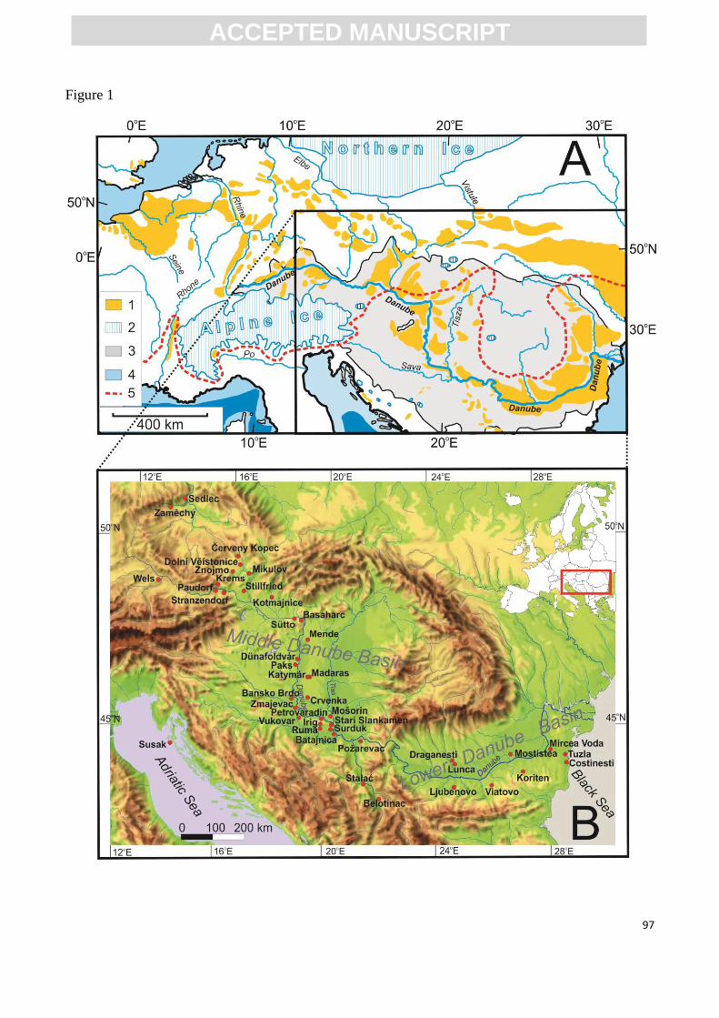
ACC
EPTE
D M
ANU
SCR
IPT
ACCEPTED MANUSCRIPT
97
Figure 1
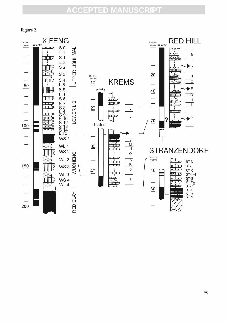
ACC
EPTE
D M
ANU
SCR
IPT
ACCEPTED MANUSCRIPT
98
Figure 2

ACC
EPTE
D M
ANU
SCR
IPT
ACCEPTED MANUSCRIPT
99
Figure 3
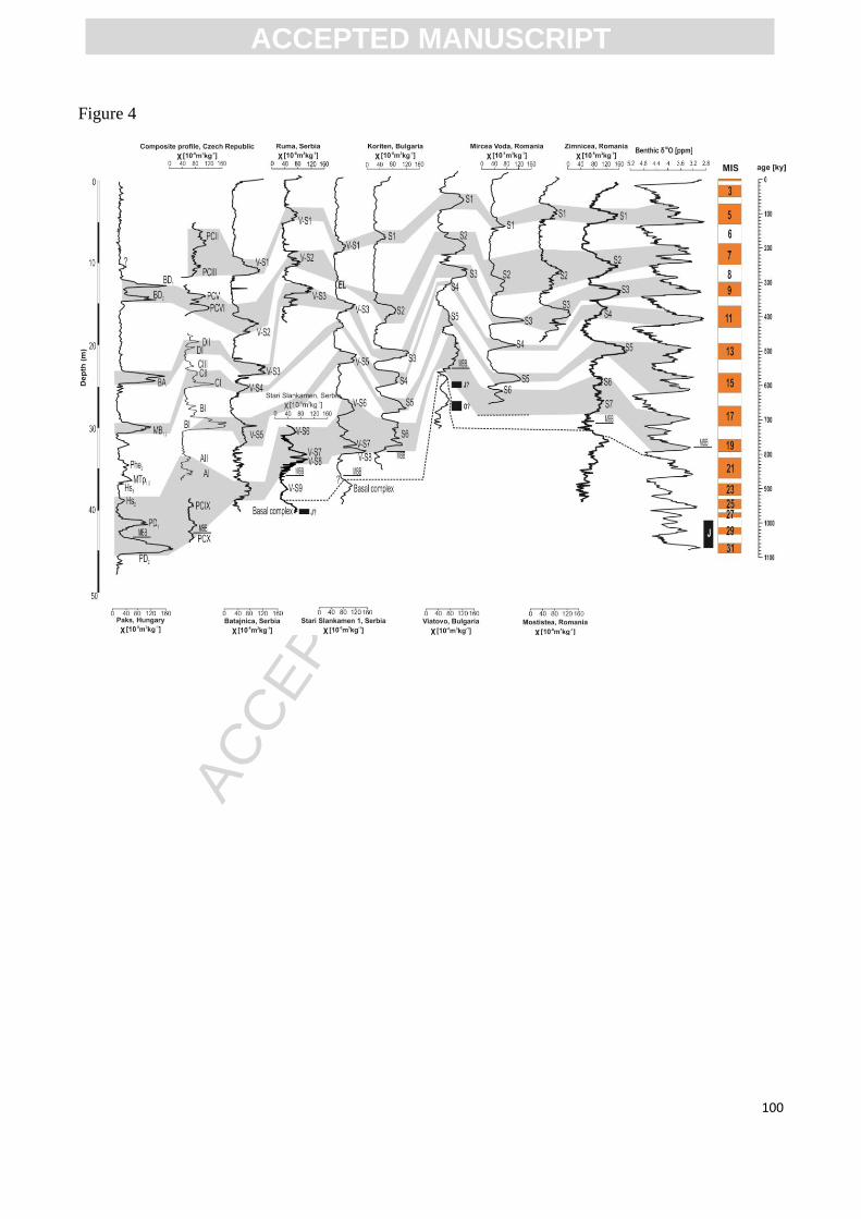
ACC
EPTE
D M
ANU
SCR
IPT
ACCEPTED MANUSCRIPT
100
Figure 4
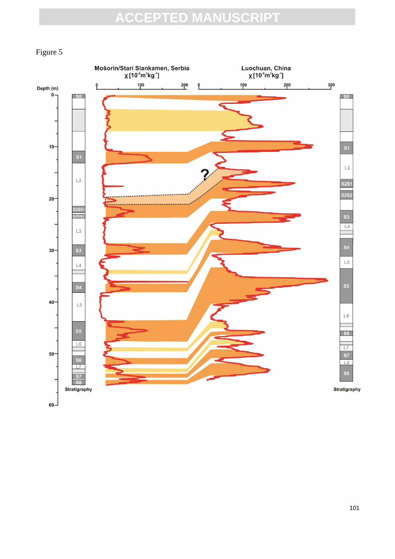
ACC
EPTE
D M
ANU
SCR
IPT
ACCEPTED MANUSCRIPT
101
Figure 5
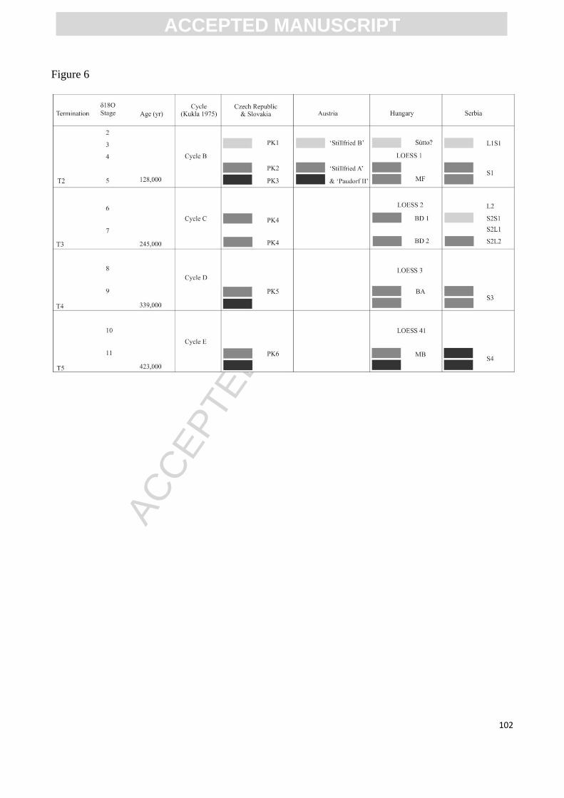
ACC
EPTE
D M
ANU
SCR
IPT
ACCEPTED MANUSCRIPT
102
Figure 6
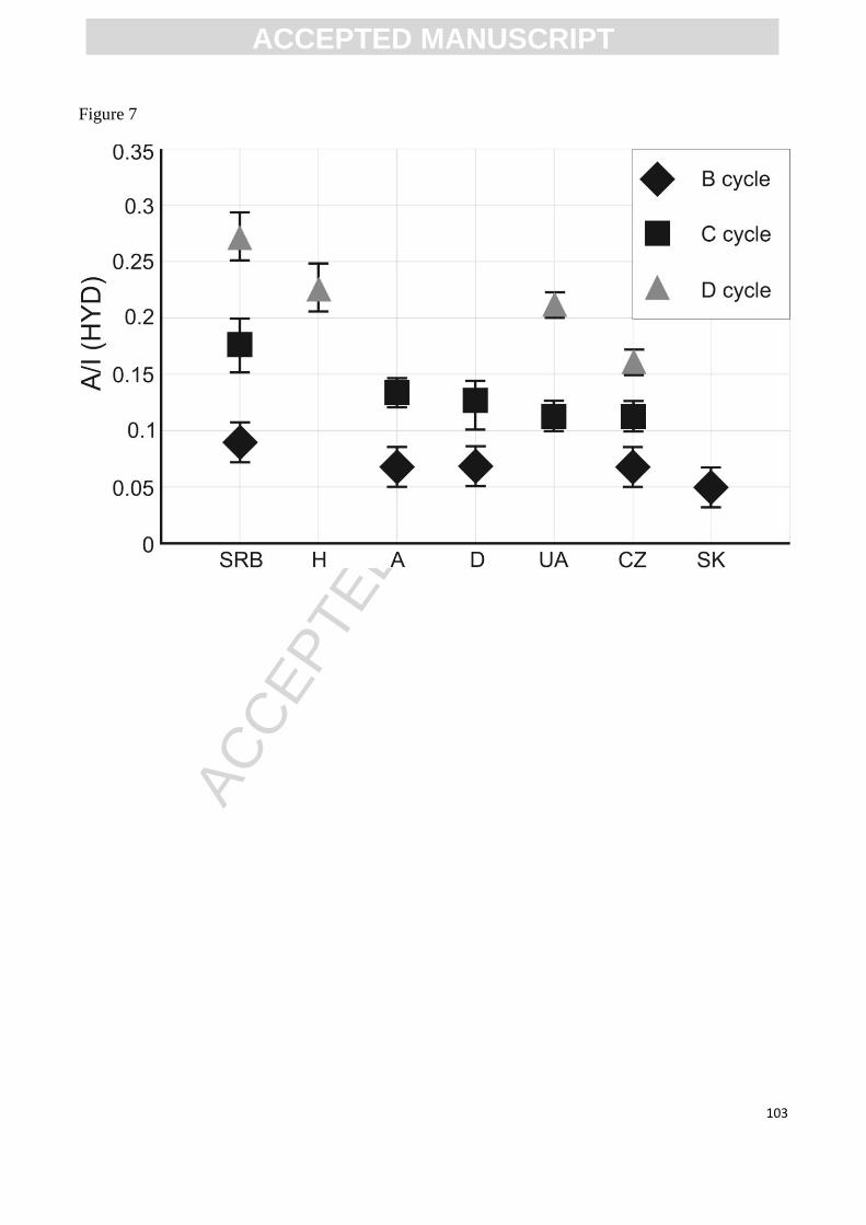
ACC
EPTE
D M
ANU
SCR
IPT
ACCEPTED MANUSCRIPT
103
Figure 7
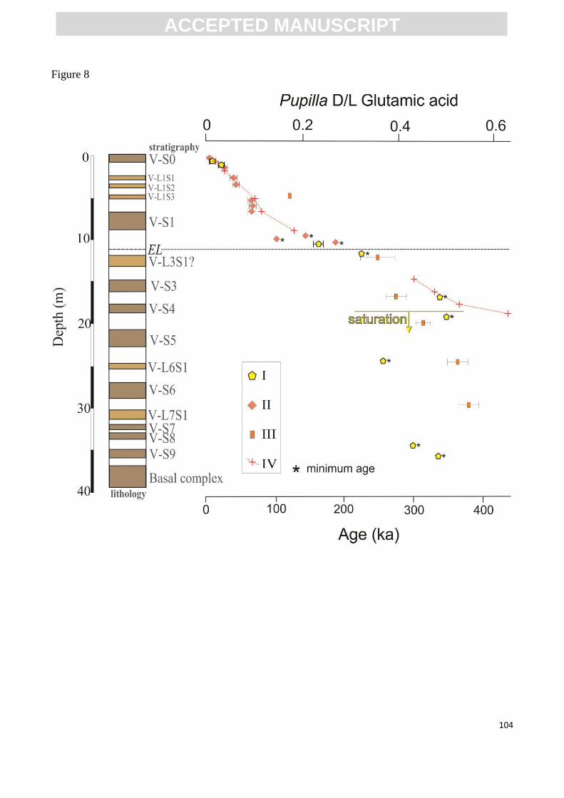
ACC
EPTE
D M
ANU
SCR
IPT
ACCEPTED MANUSCRIPT
104
Figure 8
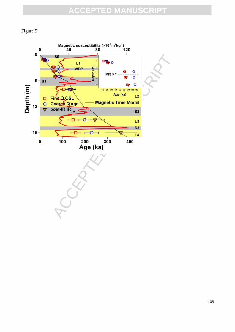
ACC
EPTE
D M
ANU
SCR
IPT
ACCEPTED MANUSCRIPT
105
Figure 9
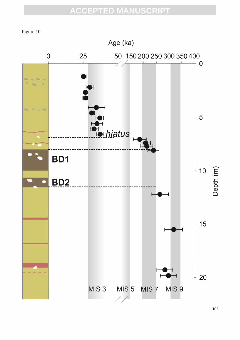
ACC
EPTE
D M
ANU
SCR
IPT
ACCEPTED MANUSCRIPT
106
Figure 10
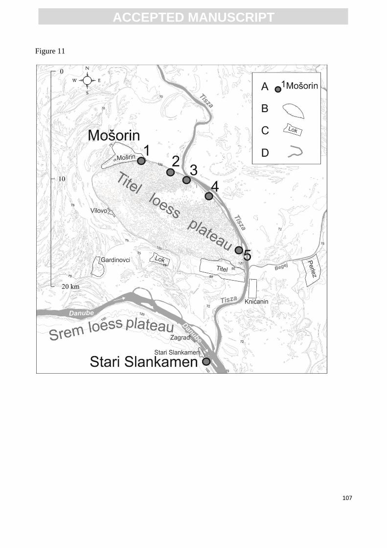
ACC
EPTE
D M
ANU
SCR
IPT
ACCEPTED MANUSCRIPT
107
Figure 11
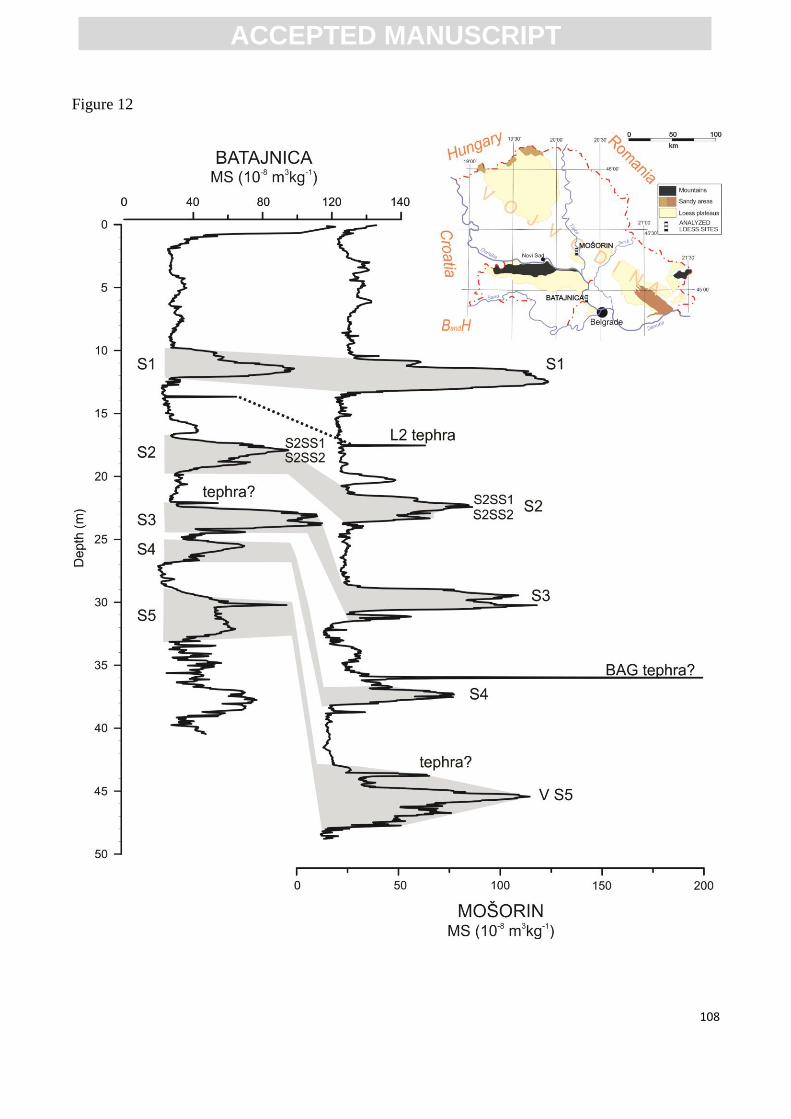
ACC
EPTE
D M
ANU
SCR
IPT
ACCEPTED MANUSCRIPT
108
Figure 12
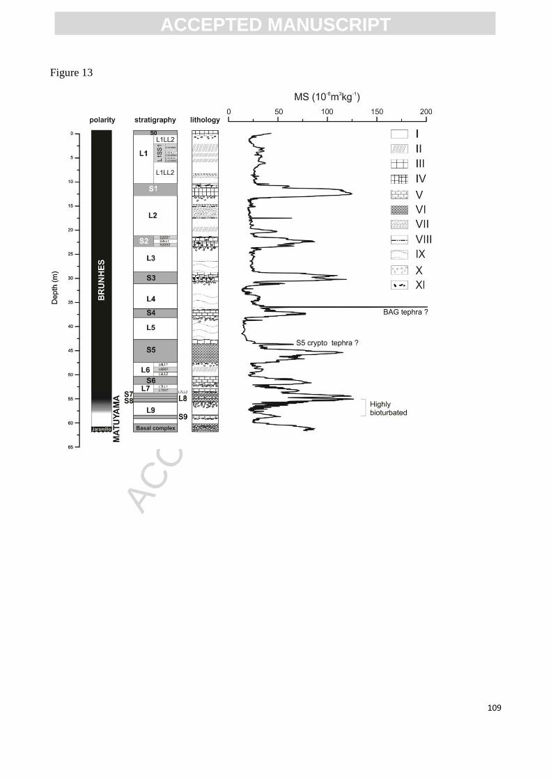
ACC
EPTE
D M
ANU
SCR
IPT
ACCEPTED MANUSCRIPT
109
Figure 13
ACC
EPTE
D M
ANU
SCR
IPT
ACCEPTED MANUSCRIPT
110
Figure 14
ACC
EPTE
D M
ANU
SCR
IPT
ACCEPTED MANUSCRIPT
111
Figure 15
ACC
EPTE
D M
ANU
SCR
IPT
ACCEPTED MANUSCRIPT
112
Figure 16
ACC
EPTE
D M
ANU
SCR
IPT
ACCEPTED MANUSCRIPT
113
Figure 17
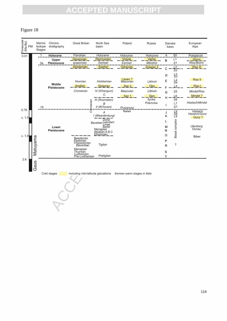
ACC
EPTE
D M
ANU
SCR
IPT
ACCEPTED MANUSCRIPT
114
Figure 18
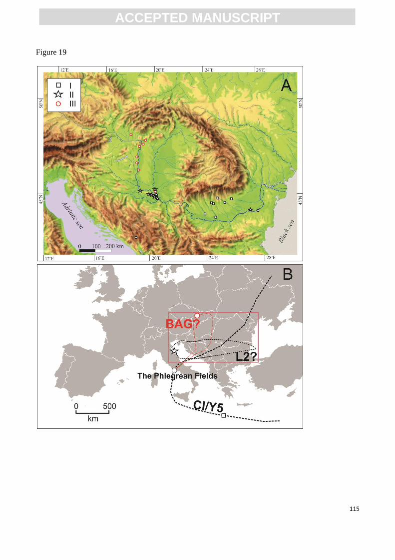
ACC
EPTE
D M
ANU
SCR
IPT
ACCEPTED MANUSCRIPT
115
Figure 19
ACC
EPTE
D M
ANU
SCR
IPT
ACCEPTED MANUSCRIPT
116
Table 1. Varying chronostratagraphic models proposed for the Stari Slankamen loess-palaesol
sequence by different researchers and their comparison to the traditional Alpine subdivision
(Bronger, 1976) and MIS stratigraphy (Singhvi et al., 1989; Butrym et al., 1991; Bronger, 2003;
Marković et al., 2011).
Bronger
(1976)
Singhvi
et al.
(1989)
Butrym et al.
(1991) Bronger (2003) Marković et al. (2011)
paleosol Alpine
sudivision MIS
paleosol MIS paleosol MIS paleosol MIS
F2 Würm
paleosols
W
5a D 5a F2 5a V-S1 5
F3 5e Not observed F3 5e Not observed
F4 G 5c F4 7 V-S3 9
F5 R-W I 5e F5 9 or
11 V-S4 11
F6 L 7 F6 13-
15 V-S5 13-15
F7 n1 9 V-S6 17
F8 n2 9 V-L7S1 18.3
F9 V-S7 19
F10 V-S8 21
V-S9 25
F11
basal
complex 29-?
ACC
EPTE
D M
ANU
SCR
IPT
ACCEPTED MANUSCRIPT
117
Table 2. The proposed Danube loess stratigraphic model, covering the last approximately one million
years, and its relation to the Chinese loess record, marine isotope stratigraphy, glacial cycles and
national loess stratigraphies in the Czech Republic (Kukla and Cilek, 1996), Austria (Scholger and
Terhorst, 2013), Hungary (Sartori et al., 1999; Ujvari et al., 2014, modified), Serbia (Marković et al.,
2011), Romania (Buggle et al., 2009) and Bulgaria (Jordanova et al., 2008).
MIS CLP Glacial
cyclle
Czechia Austria Hungary Serbia Romania Bulgaria DB
1 S0 A Recent soil V-S0 S0 S0 S0
2 L1LL2
B
AS16 V-L1L2 L1L2 L1LL2 L1LL2
3 L1SS1 PKI AS15+14 MF1 V-L1S1 L1S1 L1SS1 L1SS1
4 L1LL2 AS13 V-L1L2 L1L2 L1LL2 L1LL2
5 S1 PKII+III AS12-10 MF2 V-S1 S1 S1 S1
6 L2 C AS9 V-L2 L2 L2 L2
7 S2 PKIV AS8 BD1+2 V-S2 S2 S2 S2
8 L3 D AS8a? V-L3 L3 L3 L3
9 S3 PKV AS7a+7b?
+ 7c?
BA V-S3 S3 S3 S3
10 L4 E AS6? V-L4 L4 L4 L4
11 S4 PKVI AS5? MB1+2 V-S4 S4 S4 S4
12 L5
F-G
AS4? V-L5 L5 L5 L5
13-15 S5 PKVII +
VIII
AS3-1? Phe+Mp
t+Hs1?
V-S5 S5 S5 S5
16 L6 H V-L6 L6 L6 L6
17 S6 ? Hs2? V-S6
S6S1?
S6
18.1 L7LL1
I
V-L7L1 L7LL1
18.2 L7SS1 V-L7S1 L7SS1
18.3 L7LL2 V-L7L2 L7LL2

ACC
EPTE
D M
ANU
SCR
IPT
ACCEPTED MANUSCRIPT
118
19 S7 PKIX PD1? V-S7
S6S2?
S6 S7
20 L8 J V-L8 L8
21 S8 PKX PD2? V-S8 S8
22-24 L9 K-? V-L9 L7 L7 L9
25-? S9-? PKXI Basal
complex
? Red clay Basal
complex