Embed Size (px)
Citation preview
(2:0LCGIC STRUCTURE OP THE PENI SYLVANIAN ROCKS,
TiXOLOTE MOUNTAIN /,:\1,A, UL\I Î.ILXICO
A THESIS
IN (æOLOGfr
Rex Hale S t e v e r
Approved
Texaa Technolc g i c a l C o l l e g e
A u g u s t , 1951
snr*"™. lifiDADV
GEOLCG C STRUCTUHE OP THE rENÍ^SYLVAI.'IAN ROCKS,
TECOLOTE MOUNTAiíi ARî.A, NEW KEXICO
A TBESIS
IN CEOLOGÎ
SulDmltted t o the P a c u l t y of the D ' v i s i o n of Graduate S t u d i e s of Texas T e c h n o l o g i c a l ColIegB
i n P a r t i a l P u l f i l l m e n t of the Requirements f o r the Degree of
BÎASTER OP SCIENCE
Rex Hale S t e v e r , B. A.
Corpus C h r i s t i , Texas
August , 1951
ACKNOl'.liBDCSEíÆ^NT
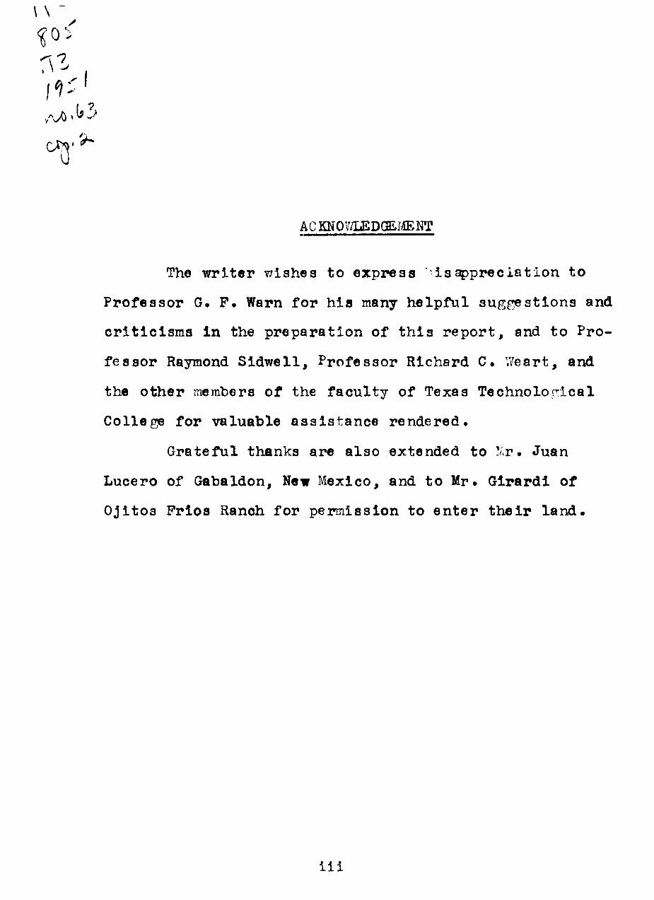
The wr i t e r wishes to express ' i i s ^ p r e c i a t i o n to
Professor G. P . Warn for h i s many helpfu suggest ions and
c r i t i c i s m s in the prepara t ion of t h i s r e p o r t , and to Pro-
fessor Raymond Sidwel l , Professor Richard C. V/eart, and
the o ther merabers of the facul ty of Texas Technolon:ical
College for valuable ass i s t ance rendered.
Grateful thanks are a lso extended to ! ' r . Juan
Lucero of Gabaldon, New Mexico, and to Mr. Glrardi of
Oji tos Prloa Ranoh for permisslon to en t e r t h e i r l and .
i i i
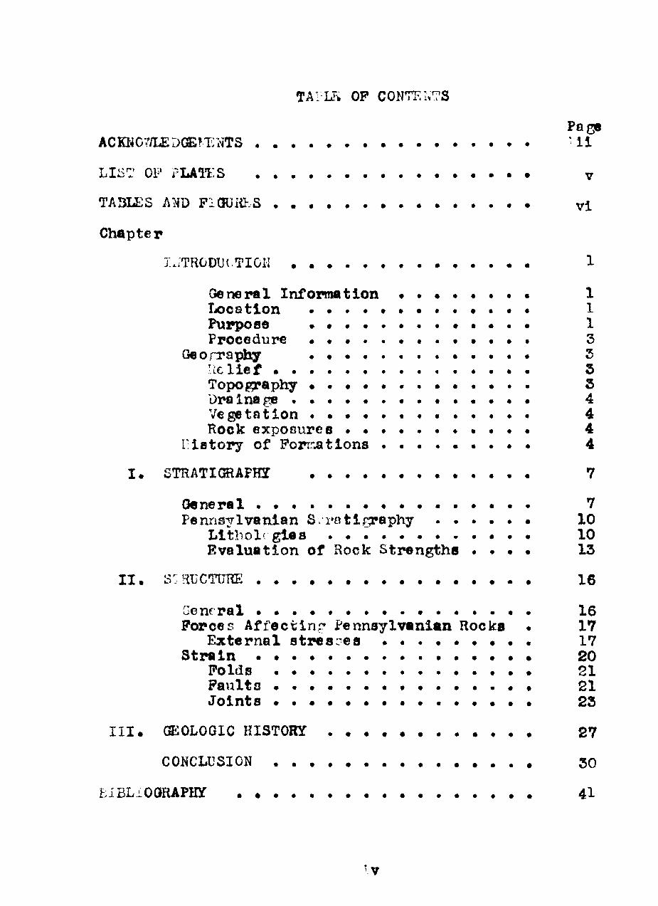
TAIL^ OP CONTENTS
Page
ACKN07/LEDC3aS!T NTS * i l
LIST OF rLAai:S • v
TA3LES Am PlOUiíF.S vi
Chapter Ix.TRODUí.TIOÎI 1
Goneral nformatlon • . • • « . . • 1 Xx)cotlon • • . . . • • • « • • • • 1 Furpose • • • • • • . . 1 Procedure • • • . . • • . • • • • • 3
Georraphy . . . . . . . . . . . . . 5 R c l i e f 5 Topography • • • • . . . • 5 Dx^inage • • • • • . • . « 4 Vegetation • • • • 4 Rock exposures • • • • • • 4
í:ÍBtory of Poznr^tions . • • . • • • • • 4
I . STRATKBAPH • 7
Oeneral • • • • • • • • • • • 7 Pennsylvanlan S •rQtîí^aphy 10
Llthol( glea • 10 Evaluat ion of Hock Strengtha • • • • 13
I I . s:: Î-GCTTJRE 16
Goneral • • • • • • • 16 Porces Affect iní ' Pennsylvanl«n Rocks . 17
External atresL^ea • « . . • • • • . 17 S t r e i n 20
Folds • 21 Paults 21 Jo ln t s • • • • • • • • • 23
I I I . C220LOGIC HISTORY 27
CONCLUSION 30
EiBLiOORAPHÍ 4 l
LIST OP PLATi:S
Plate Page
1» Index Map of San Tiguel County, New '.'exico 2
I I • Pennsylvanian Sect ion 11
I I I . Joint Map of Tecolote Mountain Area . • • • 24
IV^ Joint Diagpams • . • • 25
V. (Photographs) 33
VI. (Photographs) 35
VII^ (Photogrephs) 37
V I I I . Panoramic Viewa . • • • • • • 39
IX. Structure Sect ions • • • 40
X. Geologic Map of the Tecolote I.îountain Area, New Mexico
TABLES AÎ;D PIGURES
Table Pa,^
! • Regional Columnar Sec t ion • • . . . . . . , 8
Pigure
l Posslble shear solutions and orientation of strain axes 19
vl
GEOLOGIC STRUCTURE OP THE PENNSYLVANIAN ROCKS,
TECOLOTE i.'OUNTAIN AREA, N1:W IIEXICO
INT lODUCTION
General Information* Pennaylvanian sediments of the
area studied are s t r u c t u r a l l y a s soc ia ted wlth the Sangre de
Cris to ant i c l inor ium, a member of the Southern Rocky Moun-
t a i n Province• These and other Pennaylvanian sediments ex -
posed in the various mountain ranp^s comprise the o ldes t
sediments in north centra l New Mexico, r e s t i n g unconformably
on pre-Cambrian igneous and metamorphic rocks .
Pennsylvanian sediments are a l s o reported from the
subsurface to the west and to the eas t under the Las Vegas
Plateau of the Great Plaina Province•
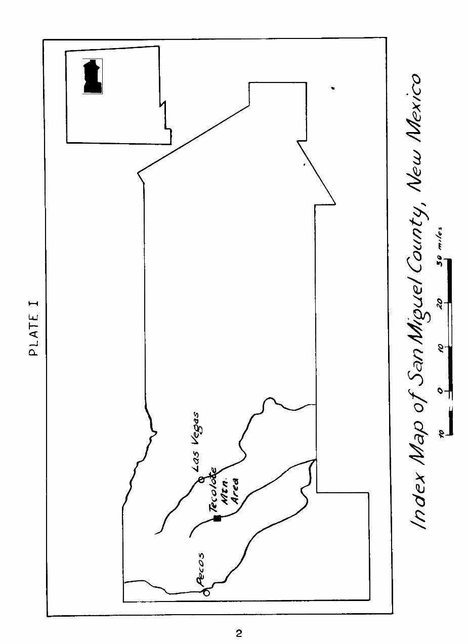
Location^ The area studied i s s i tua ted immediately
west of Tecolote Mountain, a prominent but+e which i s about
12 mi les southwest of Las Vegas, New Mexico^ (Plate I ) •
I t ia aprroxiinately 2 .8 square mi les in area l extent and
raay be reached by travelln«? weat and south on New Mexico
Highiray 67 from Romeroville to the small v i l l a g e of Gabaldoia.
Purpose. The purpose of t h i s study i s to work out
the l o c a l geo log ic s tructure and evaluate i t in terms of the
forces a p p l i e d . These cons iderat ions include the geologic
h i s t o r y of the area .
Procedure. P i e ld procedure included a d e t a i l e d
LU
.8 I 5
0
f
.0:
^
J
descrlption of Pennsylvanian litholories, determination of
the attltudea of outcropping beds and prominent Jointa with
a Bru ton compass, and measurements of thicknesaes and out-
orop dlstances. The entire area of Pennsylvanian outcrops
and the adjacent areas of Permian outcrops were extensively
studied. Most of the structures were traced by walking the
outcrops.
Geography
Relie f• Maximum r e l i e f in the area i s about 1000
f e e t , with Tecolote Mountain and Permian scarps to the
aouth and west r i s ing several hundred feet above the l eve l
of Tecolote Creek.
Topography. Upland areas consist chief ly of west-
ward dipplng Permian redbeds formlng steep east - fac ing
scarps on the south and west, and Tecolote Mountain, capped
by Permian sandstonea.
Pennsylvanian rocks, whlch outcrop in the v i c i n i t y
of Tecolote Creek, form low ant i c l ina l h i l l s controlled by
res i s tant marine l i estonea. The deeply incised meanders
of Tecolote Creek suggeat a rejuvenation In the drainage of
the region.
Low h i l l s northeast of the area studied are composed
of pre-Cambrian granites sch i s t s and pegnat i tes .
Drainage . The principal drainage consis ts of Teco-
lote Creek, an intermittent tributary of the Pecos River.
The atream pattern i s dendr i t i c througjiout the area of
Permian outcrops , but the small g u l l i e s t ravers ing the
folded Pennsylvanian rocks are subsequent, showing a t r e l -
l i s p a t t e r n .
Vegetat ion . The ch i e f vegetat ion c o n s i s t s of various
types of graases; naraely, grama, g a l l e t a , blue stem, muhly,
buf fa lo g r a s s , and timothy which are used for grazing pur-
p o s e s . Wlth the except lon of land under c u l t i v a t i o n there
i s an abundant coverage of p l n e s , scrub cedars , vine mes-
q u i t e , and some cactus^ Heaviest f o r e s t a g e , where untouch-
ed by man, i s found on the north side of h i l l s and scarps ,
e x p e c l a l l y in areas of Permian outcrops .
Rock exposures . The best exposurea of Pennsylvanian
rocks are found along Tecolote Creek, on the tops of h i l l s
adjacent to the creek, and in the numerous small t r i b u -
t a r i e s of Tecolote Creek.
Permian rocks of the Sangre de Cristo formatlon are
w e l l exposed in promlnent scarps and r idges to the e a s t ,
south , and west and are frequently found In contact wlth
Pennsylvanian rocks along the eas t ern edge of the area of
Pennsylvanian outcrops^
History of Pormations
Early g e o l o g l c a l work connected with the Pennayl-
vanian i n New ^exico cons i s t ed c h i e f l y of reconnaissance•
There was l i t t l e a t t empt a t d e f l n l n g f o r n a t i o n a l and o t h e r
s t r a t i r r a p h i c u n i t s .
He r r l ck^ (1900) c a l l e d the lower Carboni ferous rocks
exposed i n the Sandia Mountains "the Sandia s e r i e s . "
KeyesS (1903) proposed the name "Madera" fo r the g rea t
l imes tonc p l a t e a long the back slope of the Sandia Moun-
t a i n s . The name i s de r ived from the l i t t l e iv'exican v i l l a g e
of La Madera which i s s i t u a t e d on t h i s l ÍTes tone p l a t e a u .
L a t e r Keyes (1906) proposed s e v e r a l c l a s s l f l c a t i o n s fo r the
Pennsy lvan ian , Permian, and T r i a a s i c format ions of c e n t r a l
New Mexico^ However, these c l a s s i f i c a t i o n s were based on
vague and i n d e f i n i t e l i tho lo f^ ic d e s c r i p t i o n s and were never
u s e d .
Gordon^ <1907) , i n a r e p o r t fo r the G e o l c r i c a l Sur -
vey , employed the names Sandia and Madera fo r the lower
and upper Pennsylvanian in New Mexico and adopted the name
"Magdalena" from the Magdalena Mountains as a group t e r m .
This I s the accep ted c l a s s i f i c a t i o n . However, i t was not
u n t l l Read, e t a l . ^ (1944) d iv ided the Sandia and Madera
^ C. L« H e r r i c k , "Geology of the White Sands of New Mexlco", Jour* of Geblogy. Vol . V I I I , ( 1900) , p . 1 1 5 .
2 C. R» Keyes, ^ 'Geological Sketches of New Mexico", Ores and M e t a l s . Vol , X I I , (1903) , p^ 48^
3 C^ H^ Gordon, "Notes on the Pennsylvanian Porma-t i o n s i n the Rlo Grande V a l l e y , New Mexlco", Jour^ of Geology. Vol^ XV, (1907) , p^ 806•
4 C^ ?• Read e t a l « . Golopiical Map and S t r a t i r r a p h i c S e c t i o n s of Permian and Pennsy lvan ian Rocka i n P a r t s of San Mip:uel. Santa Fe , Sandova l . B e r n a l i l l c . T o r r a n c e . and Valen-c i a C o u n t i e s . North Centra New Mexico. L . S . Dept^ I n t . ^ Geol^ S u r v . , O i l and Gas I n v e s t i g a t i o n , Prel im^ Map 2 1 , (1944) •
formationa i n to înenbers tha t a workable f i e l d c l a s s i f i c a -
t i o n was obtained^ This c l a s s i f i c a t i o n , based on l i t h o -
lo^ic d i f f e r e n c e s , d iv ides the Sandia in to a lo^-if'r l i r e -
stone and upper c l a s t i c membcr and the Madera in to a lower
gray l i - e s t o n e and upper arkosic member^ As yet the mem-
bers have not been named^ This c l a s s i f i c a t i o n i s fo owed
i n t h l s paper^
CHi'-PTER I
STRATIGRAPHY
General
The sequence of rocks in the v i c i n i t y of the Teco-
lo te area comprises formatlons ranging In age from pre-
Cambrian to Cretaceous. (Table ! ) • These formations are
exposed from the Tecolote area eastward for a d is tance
of about f ive miles^ They represent the eas tern limb of
the broad Sangre de Cris to ant ic l inor ium, a t e c t o n i c f e a -
ture of Laramide age^
Pre-Cambrian rocks , which outcrop about a mile
northeast of the Tecolote area , are composed c h i e f l y of
plnk and gray grani tes and granite pegmat i tes . Some
gne l s se s and mica s c h i s t s are a l s o present^
A profound unconfoinnity separates the Pennsylvanian
and Pre-Cambrian rocka throughout northern New Mexico.
The Sandia lower formation of the Magdalena Group, c o n s l s t s
of a lower l lmestone member, which i s not present In the
Tecolote Mountain area , and an upper c l a s t i c member com-
posed of brown and gray l i m e s t o n e s , sandstones , a h a l e s ,
and marls^
The Sandia ia over la in by gray, cherty l imestones
and calcareoua sha les of the Madera formation^ The upper
: adera c o n s i s t s of c l a s t i c li^nestones and arkoses which
TABLE 1
S ystem
Cret^ceous
^u/^cfss/c
Tr/ass/c
Per/TiíaA?
fhnn sty/u<a/7 'fcin
Pre- Ccimb.
Group
Co/or<ac/o
DocÂru/n
*
Mciø</ci/enci
ror/77at/on
Qre e/7/7 or/?
Oro/7ero^
Dâ/cota
/Vlorr'/son
£r?trci c/a
C/?/r?/e
3ant<^ /?osa
San Anc/res
Yeso
SiSn^re de Cr/'sto
/Wac/era
Sanc//^
/i//ember
Siltstone
L/mestone
G/or/etta
/Jr/Cos/c //mestone
C/? ert(/ //mcs tone
C/a st/c /77 em/? er
Loojer //mestone
REGIONAL COLUMNAR 5ECT10N
8
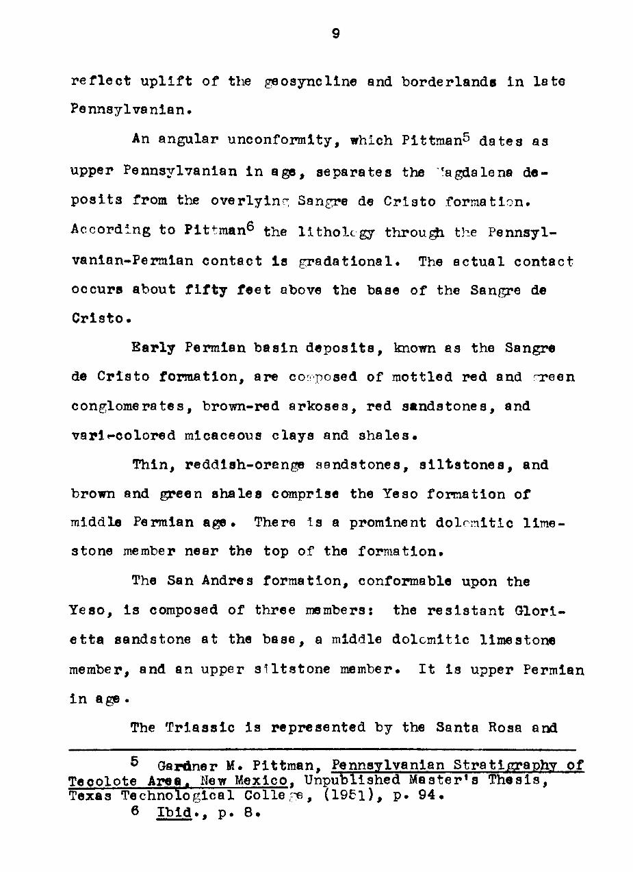
r e f l e c t u p l i f t of the geosyncline and borderlands in l e t e
Pennsylvanian^
An angular unconformity, which Pittman^ dates as
upper Pennsylvanian i n agp, separates the ^agdalena de-
p o s i t s from the overlyinr; Sangre de Cris to formation^
According to Plttman^ the l i t h o l c g y t h r o u ^ the Pennsyl-
vanian-Permian contact Is gradational^ The ac tua l contact
occura about f i f t y f e e t above the base of the Sangre de
C r l s t o .
Barly Permlan bas in d e p o s i t s , known as the Sangre
de Crls to formatlon, are co" posed of mottled red and T?een
conglomerates , brown-red arkoses , red sandstones , and
varl'-colored raicaceous c lays and s h a l e s .
Thin, reddish-orange sandstones, s i l t s t o n e s , and
brown and green shales comprise the Yeso f o m a t i o n of
middle Permian age . There s a prominent do lemit ic l ime-
stone member near the top of the formation.
The San Andres formation, conformable upon the
Yeso , i s composed of three members! the r e s i s t a n t Glori -
e t t a sandstone at the base , a middle dolomit ic l imestone
member, and an upper s i l t s t o n e member. I t i s upper Permlan
i n age .
The T r i a s s l c i s represented by the Santa Rosa and
^ Gardner M. Pittman, Pennsylvanian Stratigraphy of Teoolote Area. New Mexico. Unpublished Master*s T h e s i s , Texas Technological Colle , ^ , ( 1 9 5 l ) , p . 9 4 .
6 I b i d . . p^ 8 ,
10
Chinle formations^ The Santa Rosa i s primarily a grecnish-
t a n , "dirty", cross-bedded sandstone with l enses and wedr^s
of conglomerate • The Chinle c o n s i s t s of t h i n , tan, red
and purple , f ine -gra lned sandstones , sandy s h a l e s , c l ays
and c onglomc ra 1 e s •
The Jurass lc system i s composed of the Entrada and
Morrison forraations• The Entrada c o n s i s t s of t h i n , gray
to buff , limy sandstones^ I t i s over la in by thc t h i n , gray,
a r g i l l a c e o u s Todi l to llmestone which i s t le basal rnember
of the ?Æorrlson formation^ The l a t t e r c o n s i s t s of a f i n e -
grained arkosic sandstone and a l t e r n a t i n g varicolored
c l a y s t o n e s , marls , sandstones , s i l t s t o n e s and nodular
l imestones •
Cretaceous rocks include the Dakota sandstone, a
r e s i s t a n t ridrre formlng rock, the Graneros s h a l e , and the
Greenhom limestone^
According to Sidwell^^ the highly cross-bedded
sandstones and shales of middle Permian to Cretaceous age
represent a platform envoronment^
Pennsylvanian Stratigraphy
L i t h o l o g i e s • Pennsylvanian rocka of the Tecolote
Mountain area c o n s i s t of l imes tones , sandstones , s h a l e s ,
and conglomerates . Lîmestones c o n s t i t u t e approxirîiately
7 Raymond S i d w e l l , "Sediments at the Southern Ter-
mlnatlon of the Sangre de Cristo Antic l lnorium", Jour. of Sedimentary Petro logy . Vol . XVIII, No. 3 , (1948) , pp 100-101
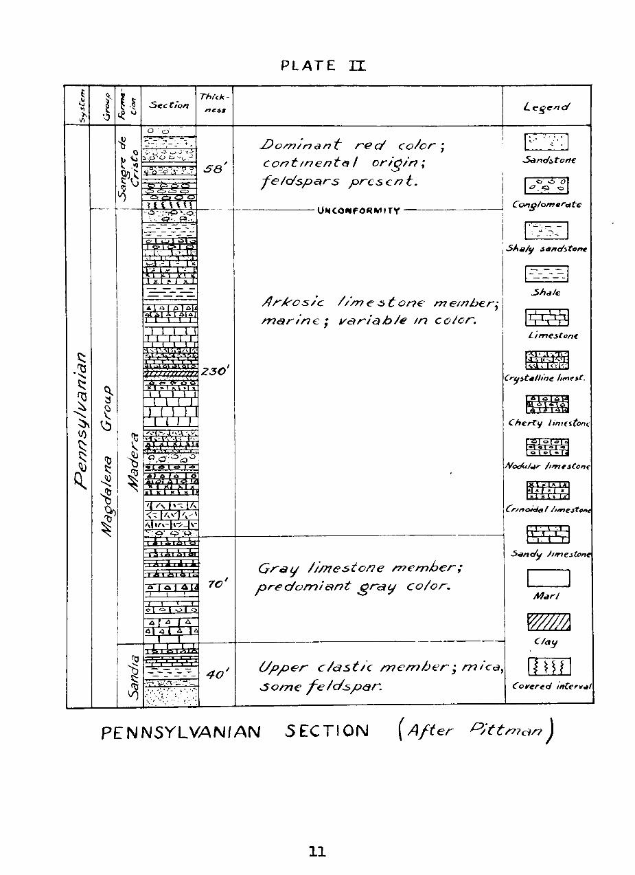
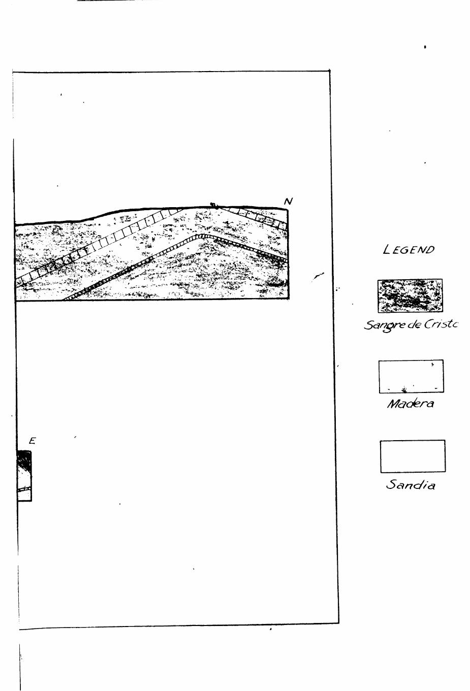
PLATE H
Legenc/
Do/n/ncint r€c/ co/cr \ ccnt/nent<31 or/^/n ; /e/dsp&rs prescnt.
Sancfí,toft€
o o o
ONCO«FO«M»TY Conø/om^rfjte
I S/i « / ^ s sfft/i tont
/}/^/ccs/c //m € -st one m e/nher^ m&r/nc ; i/<ar/cib/e /n co/cr.
3h^/e
7/^\ \ \ \
A/ocAj/mtr Jifntitont
Onâi^ ///?7estor?€ mem/íer; predom/cint ^Acîd/ co/or.
C/ppc'r c/ast/c member -, m/ca^ Some fe/d^pâr.
Lim€ston<
^m SIESE
Chertt^ linifstont:
«=>! o | o l o| ô t ô I ^ ° t ' - t * l^
- t i - l J l/f Cr/noté^ / /finestoftt
•' r 'i -•y T - 1 -r-r-T
S^nc/u Jffneitone
/H^r/
wm m.
Coíferfd interv^l
?EUr^SyLVAN\/\N 5ECTI0N [After l^/ttmo/?)
11
12
58 percent of the s e c t l o n , with both normal marine and
bioatromal typea p r e s e n t . 8 (piate I I ) .
Limestones of Sandia age are dominantly f ine -gra ined ,
a r g i l l a c e o u s and highly mlcaceous. They contain prominent
amounts of Iron oxide which imparts a dark brownish-black
to orange c o l o r , making the l i n e s t o n e s read i ly d i s t i n m i s h -
able in the f i e l d . They are general ly t^ln to medlum bedded.
Weathered f o s s i l a leave the exposed surfaces h i ^ l y Irregulan
Madera llmeatones are t y p i c a l l y f ine to medium grain-
ed , c r y s t a l l l n e , w e l l - c o n s o l i d a t e d , somewhat q u a r t z l t i c ,
and quite cherty . However, some limestone members are
poorly conaol idated and earthy . Their f resh co lors are
whi te , pale y e l l o w , and l i g h t gray, usua l ly weathering
tan , dark gray, or b lack . Bedding i s r e l a t i v e l y massive ,
but chert nodules and a high f o s s i l content provide i r -
regular surfaces where weathered.
Although the l imestones and marls themselves are
Ind lca t lve of s table platform cond i t lons , the t y p i c a l
Pennsylvanian d e p o s i t i o n a l c y c l e s in the area studled
sug :e s t a f l u c t u a t i o n between r e l a t i v e l y atable and r e l a -
t l v e l y unstable condi t ions during Magdalena t ime .
Shales comprise about 8 perc< nt of the sediments
i n the Tecolote area , t h i s amount being somewhat lower
than the average amount in Pennsylvanian sequences in New
Q
° Pittman, op. c i t . . p . 5 7 .
13
Mexico.^ They are micaceous, ca lcareous , ferruglnous , and
o c c a s l o n a l l y contain f o s s i l s . The shales are t h i n , f r e -
quently f i s s i l e , and vary in color from mottled red and
black to green and y e l l o w . Ironstone concret ions conta in-
ing euhedral c a l c i t e c r y s t a l s are sometimes found In the
shale s .
Red, brown, and gray sandstones are found at i n t e r -
va l s throuf^out the Pennsylvanian sequence. Cenentlng
materia la are calcium carbonate, s i l i c a , and iron o x i d e s .
Sandstones of the uppcr Sandla contain well-rounded and
we l l sorted quartz grains and cr inoid fragments, and show
a h o r i z o n t a l banding suggest ive of mild current a c t i o n .
The bedding i s th in to medium and i r r e g u l a r . Contrasted
with these sandstones are the upper Madera arkoses , which
are coarse-grained and contain angular f r a ^ e n t s of f e l d -
spar and quartz i te • They are th in to massive and i rregu lar -
ly bedded. Part of the sandstones are fitable .
Conglomerates, composed c h i e f l y of limeatone nodules ,
are a s soc ia ted with the l imestones and marls . Some conrse ,
q u a r t z i t i c conglomerates are as soc ia ted with the sandstones .
Evaluat ion of Rock Strengths
One important aspect of the structure of a region
i s the r e l a t i v e competency of the s t ra ta Involved. Com-
petent beds do not "support" folda but serve to contro l the
9 I b i d . . p . 5 9 .
14
aymmetry of a f o l d , reduce pressure under the arch, and
transmit s tresses .^O
Bai ley W l l l i s s t a t e s :
In order that any stratum s h a l l be competent, i t should possess c e r t a i n inherent c h a r a c t e r i s t i c s i n a degree superior to that in which they are possessed by other s t r a t a . These q u a l i t i e s are (a) s trength to r e s i s t shearing; (b) capaci ty to hea l fractTires; (c) s t i f f n e s s or i n f l e x i b i l i t y . On the other hand, the condit ions which favor i n -competence of s trata in fo ld ing arc (a) lack of coherent s trengthj (b) lack of cer^^nting q u a l i t y ; (c) f l e x i b i l i t y . l í
A l s o , according to B i l l i n g s ^ ^ , massive formations are more
competent than thinner beds with the same composlt ion.
The r e l a t i v e s trengths of sedimentary rocks , in
decreas ing order, are l lmestone , sandstone, and s h a l e .
Limestones show a compressive strength of 11,000 to 30,000
pounds per square inch.^^ Crysta l l ine v a r i e t i e s are e s -
p e c i a l l y strong because they are f ine-gra ined and compact,
and because the gpains or c r y s t a l s i n t e r l o c k . Other fac tors
i n the s trength of l imestone are i t s a b i l i t y to heal a f t e r
f r a c t u r i n g and i t s frequent r e l a t i v e maasiveness . Sand-
s tones are not as competent as l imestones because they are
r i g i d , thus are more e a s i l y fractured . Prequently they
10 C. M. Nevin, Pr inc ip le s of Structural Geologv. (4 th e d . ; New York; John Wiley & Sons, I n c , 1949) p . 5 4 .
H Eai ley W i l l i s , Geolop:ic S truc tures . (3rd. e d . ; New Yorkj McGraw-Hill Co . , 1934) ?• 8 0 .
12 Marland P^ B i l l i n g s , Structural G e o l o ^ . (New York: P r e n t i c e - H a l l , 1^0. , 1942) p . 8 9 .
•'• W i l l i s , o p . c i t . , p . 80^
15
have cementinf? q u a l i t i e s . S h a l e s , re[/-ardless of type ,
can never overcome the inhcrent weakness caused by t h e i r
t h i n bedding and s l i g h t induration^ They are subject to
p l a s t i c flow between more competent layers^
While the above r e f e r s to indiv ldual l a y e r s , the
usual s i t u a t i o n i s an a l t e r n a t i o n of beds of varyinr de-
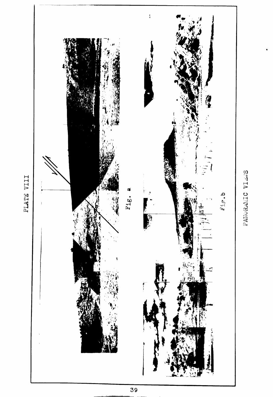
øpees of competency^ The th ick , c r y s t a l l i n e l imestones of
lower and middle Madera age (Plate Vl l -a and Plate VlII -b)
are the competent layers in the Tecolote Mountain a r e a .
Underlying c l a s t i c s and over ly ing arkoses are l e s s com-
p e t e n t . Wlthin the limestone u n i t s , unindurated marls and
underclays a s s o c i a t e d with masaive l i : es tones have acted
as lubr icants durlng t h r u s t i n g . (Plate I I ) .
CHAPTER II
STRlfCTURE
Ge ne ra 1
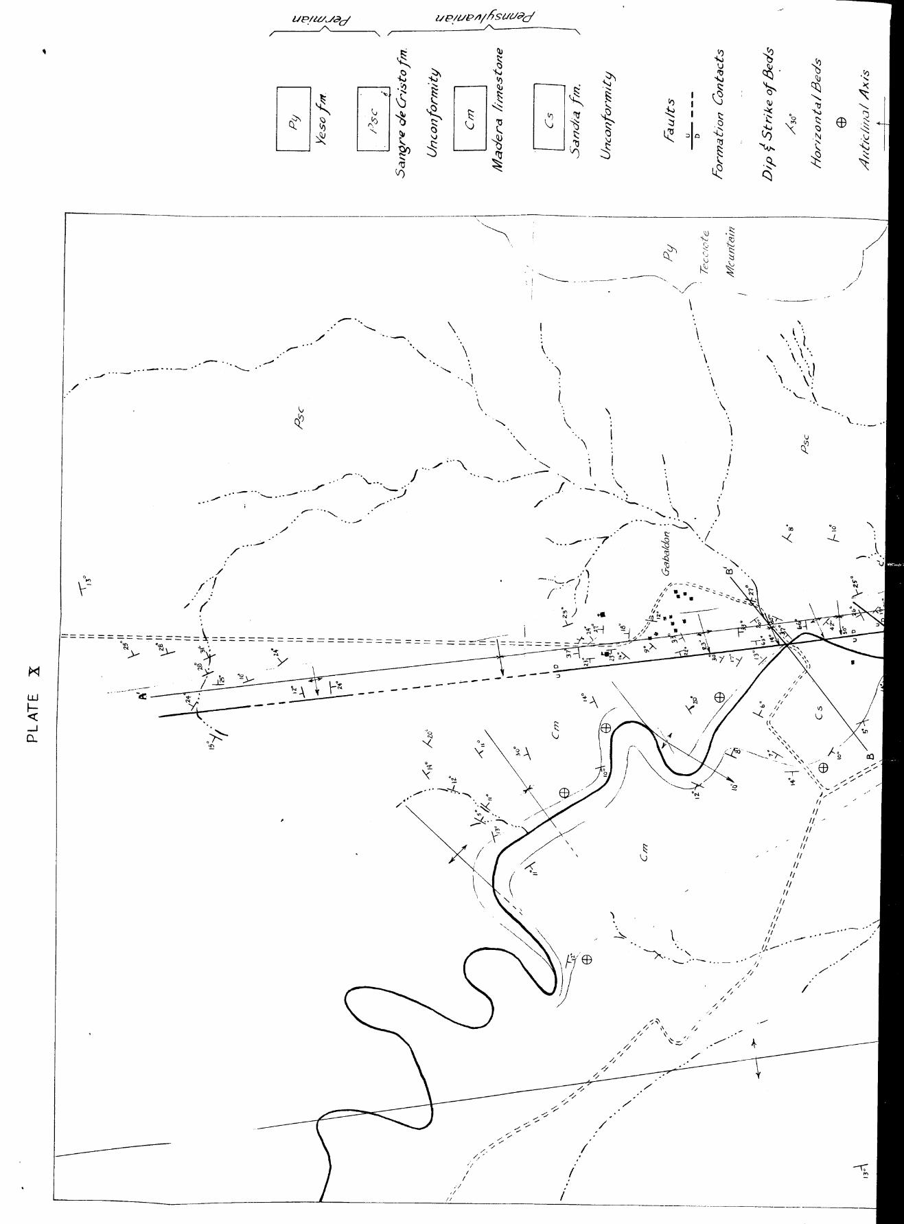
The Tecolote Mountain area cons i s ta of a narrow b e l t
of Pennsylvanian rocks exposed between younger formations
of Permlan a g e . (Plate X ) . The use of the word "Pennsyl-
vanian'* i s here in taken to mean rocks of f'agdalena a'^.
The s o - c a l l e d " trans i t i on beds" include approximately 50
f e e t of coarse quartzose and arkosic conírlomerates and
sandstones of supposed upper Pennsylvanian-lower Permian
a g e . These beds are grouped in t h i s paper with the Permian
rocks wlth which they are s t r u c t u r a l l y a s s o c i a t e d .
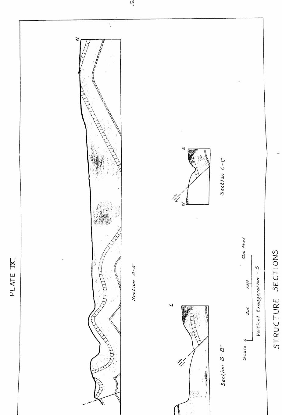
The Pennsylvanian rocks have undergone two d i s t i n c t
periods of deformation. The e a r l i e r deformation in t h i s
area i s recognized as post-Magdalena-pre-Sangre de Cris to
i n a g e . This i s shown by the unconformable r e l a t i o n of
the Sangre de Cris to formation upon the folded and apparent-
l y truncated Madera. (Plate IX, s e c t i o n s B-I » and C-C')»
This upper Pennaylvanian dis turbance , accompanied by t i l t -
ing of the Magdalena beds to the southwest, created a
aystem of c c s e l y f o l d e d , p a r a l l e l , concentric fo lda with
a northeast -southwest s t r l k e and a southwest plunge.
Overthrusts to the south devcloped as a r e s u l t of continucd
s t r e s s .
16
17
The Laramide r e v o l u t i o n , post-up rr Cretaceous in
northern New ' ' ex i co , r e su l t ed in the formation of the broad
north*»3outh trending Sangre de Cris to ant ic l inor ium and
succeeded In c r o s s - f o l d i n g tho already folded Pennsylvanian
rocks in the Tecolote area . Thia ant ic l inorium plunges
to the south . A major normal f a u l t , s t r i k i n g north and
south and downthrown to the e a s t , accompanied t h i s fo d i n g .
(P la t e s VII, IX, and X ) . I t i s evident from s e c t i o n s B-B»
and C-C» that t h i s f a u l t i s assoc ia ted with the Laramide
f o l d i n g , which i t p a r a l l e l e . The sec t ions a l s o i l l u s t r a t e
the c r o s s - f o l d i n g in the Pennsylvanian rocks .
Porces Af fec t ing Pennsylvanien Rocks
External s t r e s s e s . S tre s se s exerted on a rock mass
from an outs ide source , as d i s t ingu i shed from those a c t i n g
wi th in a s lng le rock u n i t , are known as external s t r e s s e s .
Types of ex terna l s t r e s s are as fo l lowsj s t r e s s e a caused
by the weij^t of over ly ing mater la l , t ens iona l s t r e s s e s ,
compresslonal s t r e s s e s , and coup les , or shearing s t r e s s e s .
The unconformity at the top of the Magdalena repre-
aerts a formerly e x i s t i n g volume and weigjit of rock of un-
known magnitude. Assuming an average s p e c i f i c gravity of
2 . 8 , a cubic foot of rock would weigh 175 pounds; and a
pressure of 1.15 pounds would be exerted on each aquare
inch of the base . At a depth of one mile the pressure
18
would be 6415 pounds per sqiiare inch.^^ Slnce rocks can
r i t h s t a n d a crushing force of several times t h i s amount,
i t i s doubtful i f the former rock mass a : ove the unconformity
i n the Tccolote area represented e n o u ^ V70i^t to deform the
underlying rocks . Howevcr, the v / e i ^ t of rock no doubt i n -
f luenced the deformation by supplying confininr; p?rssures .
By Cretaceous time the th ick mantle of sediments exerted a
much greater pressure on Pennsylvanian rocks . Erosion durin/5
Cenozoic t lne re leased part of t h i s pressure , r e s u l t i n g in
an upward adjustment of the more deeply buried sediments .
The main ex terna l s t e s s e s applied during the Pennsylvanian
f o l d i n g are e i t h e r t e n s i o n a l , compressional, or shear ing .
The presence of thrust f a u l t s in the Pennsylvanian rocks
a long Tecolote Creek south of Gabaldon precludes a t en -
s i o n a l I n t e r p r e t a t i o n , although tens ion j o i n t s due to
f o l d i n g ( s t r ike j o i n t s ) were observed on the c r e s t s of
a n t i c l i n e s north of Gabaldon. Furthermore, the obvious
r o t a t i o n of the southernmost thrust (Plate X) el iminRtes
compression as the causat ive force and e s t a b l i s h e s a shecr-
Íng couple as the probable ex terna l force . Althourrh con-
ceding the p o s s l b i l i t y that the shears are components of a
co"ipressive f o r c e , the wrl ter b e l i e v e s t h i s to be a l e s s
l i k e l y e x p l a n a t i o n . Mead w r i t c s :
I t aeems probable that the movements between
14 W i U i s , op. c i t . . p . 1 1 .
19
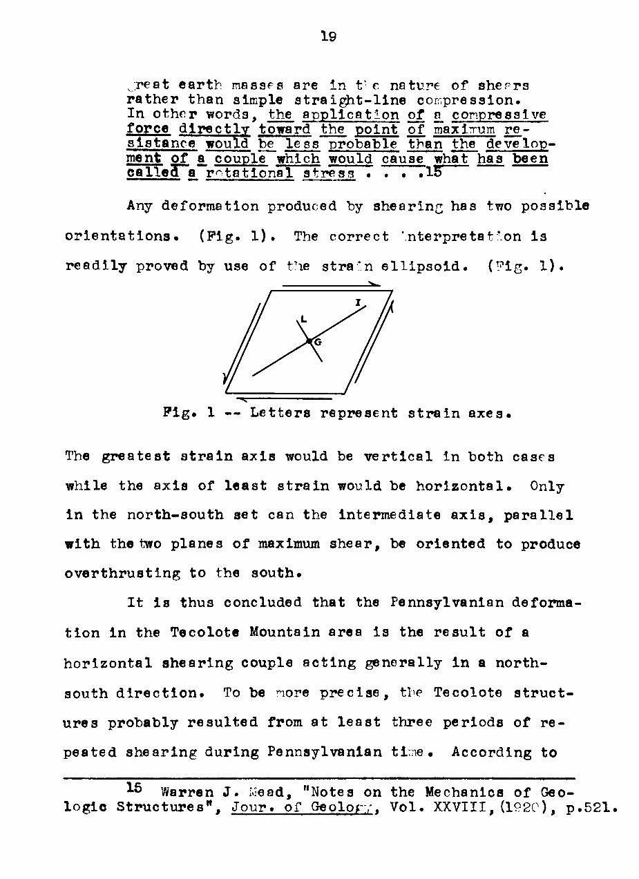
^:reat earth masscs are in t' e neture of sherrs rather than simple s t r a i g h t - l i n e compression. In othor words, the appl i ca t on of a_ conpressive force d i r e c t l v toward the point of maxÍTum r e -s i s tance would be l c s s probable tban the develop-ment of a_ couple which would cause what has been c a l l e ^a r^tat iona l s t r e s s • . • •IS
Any deformation produced by shearinn; has two poss ib le
o r i e n t a t i o n s . (Pig- 1)» The correct 'n terpre ta t lon i s
r e a d i l y proved by use of the stra In e l l i p s o i d ^ (Pig^ 1) •
P i g . 1 — Let ters represent s t r a i n a x e s .
The greates t s t r a i n a x i s would be v e r t i c a l in both cascs
while the a x i s of l e a s t s t r a i n would be h o r i z o n t a l . Only
in the north-south se t can the intermediate a x i s , p a r a l l e l
with the two planes of maximum shear, be oriented to produce
over thrus t ing to the south.
I t I s thus concluded that the Pennsylvanian deforma-
t i o n in the Tecolote Mountain area i s the r e s u l t of a
h o r i z o n t a l ahearing couple a c t i n g general ly i n a north-
south d i r e c t i o n ^ To be nore p r e c i s e , tbe Tecolote s t r u c t -
ures probably r e s u l t e d from at l e a s t three periods of re -
peated shearing during Pennsylvanian ti^ne . According to
IS Warren J . iMead, "Notes on the Mechanics of Geo-l o g i c Structures" , Jour^ of Geolorv. Vol^ XXVIII, (192C), p . 5 2 1 .
20
Sidwel l l6^ the Magdalena sequence of basa l l imes tones ,
c l a s t i c s , maanive l imestones and as soc ia ted c h e r t s , and
arkoses indicate the fo l lowing d ias trophic movements; ( 1 ) ,
u p l l f t of the source areas in middle Sandla t ime; (2) ear ly
Madera subsidence in the geosync l ine; and ( 3 ) , l a te Madera
oror«ny. The wr i t er suggests tliat d i f f e r e n t l a l s t r e s s e s
created by these movenents t i l t e d , f o lded , and faul ted
the s t ra t a in the Tecolote area .
The Laramide deformation presents a regional problem
beyond the scope of t h i s paper. However, c er ta in obser^^a-
t i o n s can be made. P i r s t , the Laramide s t e s s e s were r^ro-
bably of much greater magnitude than the Pennsylvanian
s t r e s s e s . Second, f o l d a: es s tr ike northwest, almost at
r i ^ t angles to the Pennsylvanian f o l d s . Third, f a u l t i n g
i s of the normal type . Rotat ion i s suggested in the Teco-
l c t e area by the d i f f e r e n t o r i e n t a t i o n of fo ld axes on
opposite s ides of the major normal fau l t and the r e l a t i v e l y
low d ip (45° south of Gabaldon) of the f a u l t . The wr i ter
thus e n v i s i o n s l o c a l shearing and tens iona l s t e s e e s which
are probably components of reg ional compressional s t r e s s e s .
S tra in
Both d i s t o r t i o n . channje in shape, and d i l a t i o n .
change i n s i z e , occur in rocks that have undergone
16 S l d w e l l , op* c i t . . p . 106.
21
deformatlon. The compoaite resul t i s s t ra in . Strains
commonly conslst of f o l d s , f a u l t s , jo lnts and cleavage.
Polds. The folda in the Tecolote area, (with the
exception of the croas-folds formed in the Pennaylvanian
rocks by Cretaceous force s ) , are of two types: (1) r e la -
t ive y t i g h t , s i m i l s r , asyrnnetr ical , pli nping f o l d s ; and
( 2 ) , broad, concen t r i c , Gy^-^etrical fo lds vr'iich a l s o are
plunrin^;. The t ght fo ld in^ and overthrustinc" occur in
the southern pa r t of the Tecolote a rea , v/liich has under-
gone the -Teatest deformatîon. llorthward, the folds are
l a r g e r , l e s s co . ip l ica ted , and inore syi'nractrlcal. Tíiis i s
r e a d i l y secn from sec t ion A-A^.
Polds vrøst of the noinal fau l t have s t r i l i es raiiglng
frora .:320x: to Î>î54* 'î and a shalloT/ plunrx3 :i t e::cceding
l O ^ . ( P l a l Q X ) .
In the narrow b c l t eact of the normal f a u l t and
nor th of the low angle t h r u s t , the fold axes are r:ore or
l e s s p a r a l l e l , s t r i l r ing Í:75^-OOOT> ^ Pl-aiiccs arc v a r i a b l c ,
r a n g i n r Trom 14^ to 50O. Thcse are the s teepeat p lu i^es
found in the r e g i o n .
South of the lou-angle t h r u s t , fold axes have an
averri^^ s tr iks of about N45^.. There i s l i t t l e or no
plunge .
Paul t s . Thrust faul t s of Pennsylvanian age occur In
the southern part of the area studied. (Plate X)^ Madera
22
l imestones are overthrust to the south in each case^ The
northermost of these (Plate V, Pigurea a and b) has been
t e n t a t i v e l y mapped, as a r e l a t i v e l y h l ^ - a n g l e thrust^
I t i s conceded the angle i s probably much lower than i l l u s -
t r a t e d , in which case the heave would be quite large • Tha
s t r a t i g r a p h l c throw i s est imated at 70 f e c t .
About 300 yarda to the south a minor hlgh-angle
thrust i s c l e a r l y v l s l b l e in both the e a s t and west banks
of Tecolote Creek. (Plate VI, P i g . a ) .
The f a u l t s t r l k e s N65<^ and dlps approximately 700
to the northwest . I t appjears to be a d i p - s l i p oblique fau l t
wi th a s t ra t igraph lc throw of about 20 f e e t .
Southward along Tecolote Creek a low-angle thrust Is
exposed i n a small run in the west bank. (Plate VI, P i g . b)
The f a u l t a t t i t u d e i s not readi ly determined because the
Laramide c r o s s - f o l d i n g has folded the f a u l t sur face . How-
e v e r , the s t r ike i s Judged to be northeast -southwester ly
and the d p to be about 20^-25° northwest. The low dip
and the f a c t that a l l f o l d axes north of the f a u l t are
or iented d i f f e r e n t l y from those to the south suggest r o -
t a t i o n and p o s s i b l y a greater raagnitude and Importance for
t h i s f a u l t .
A major normal f a u l t of Cretaceoua age traverses the
Tecolote area f o r over a mile i n a general north-south
d l r e c t i o n . (Plate X ) . In a stream cut south of Gabaldon
23
the adjacent minor f a u l t s (Sce e x p l a n - t i o n of Pig^ a,
Plate VIII) provide an e x c e l l e n t clue to the r e l a t i v e
moveraent of the major faul t^ They are downthrown to the
e a s t and t h e i r d ips average 46o northeast^ The s t r a t i -
graphic throw at t h i s point i s est imated at 165 feet^ I t
i s considered to be an o b l i q u e - s l i p f a u l t and the r e l a t i v e l y
low dip angle i s suggest ive of rotat ion^ The o r i e n t a t i o n
of f o l d axes north of Oabaldon on opposite s ldes of the
f a u l t further substant iatea t h i s theory^
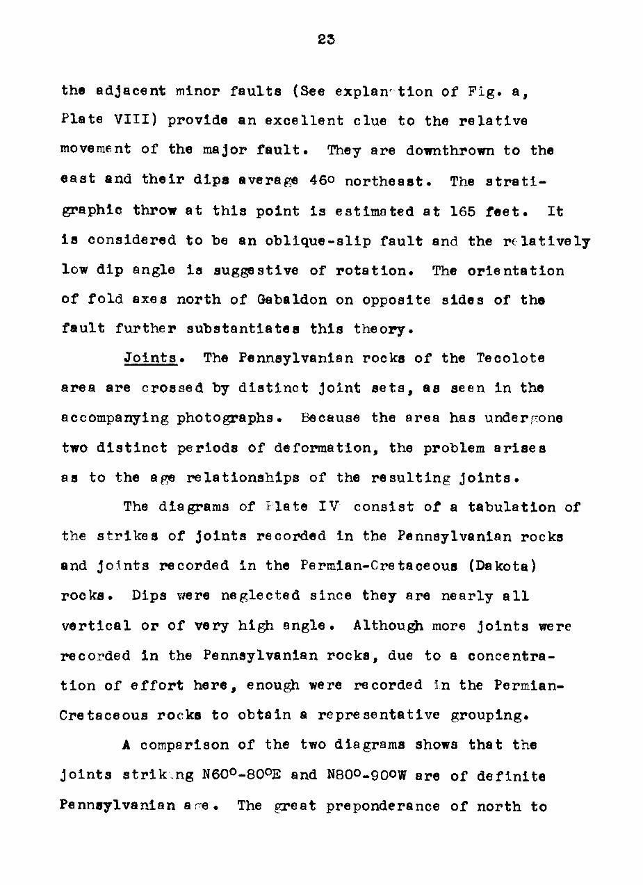
J o i n t s . The Pennsylvanian rocks of the Tecolote
area are crossed by d i s t i n c t Joint s e t a , as seen in the
accompanying photographs. Because the area has undergone
two d i s t i n c t periods of deformation, the problem a r i s e s
as to the age r e l a t i o n s h l p s of the r e s u l t i n g j o i n t s .
The diagrams of Flate IV c o n s i s t of a tabulat lon of
the s t r i k e s of j o i n t s recorded in the Pennsylvanian rocks
and Jo5nts recorded in the Permian-Cretaceoua (Dakota)
r o c k s . Dips v/ere neglected since they are nearly a l l
v e r t i c a l or of very high a n g l e . Althougji more j o i n t s were
recorded in the Pennsylvanian rocka, due to a concentra-
t i o n of e f f o r t here , enough were recorded In the Permian-
Cretaceous rocks to obtain a representat ive grouping.
A comparison of the two diagrams shows that the
j o i n t s s t r i k . n g N6OO-8OOE and N8OO-900W are of d e f i n i t e
Penneylvanian a r e . The great preponderance of north to
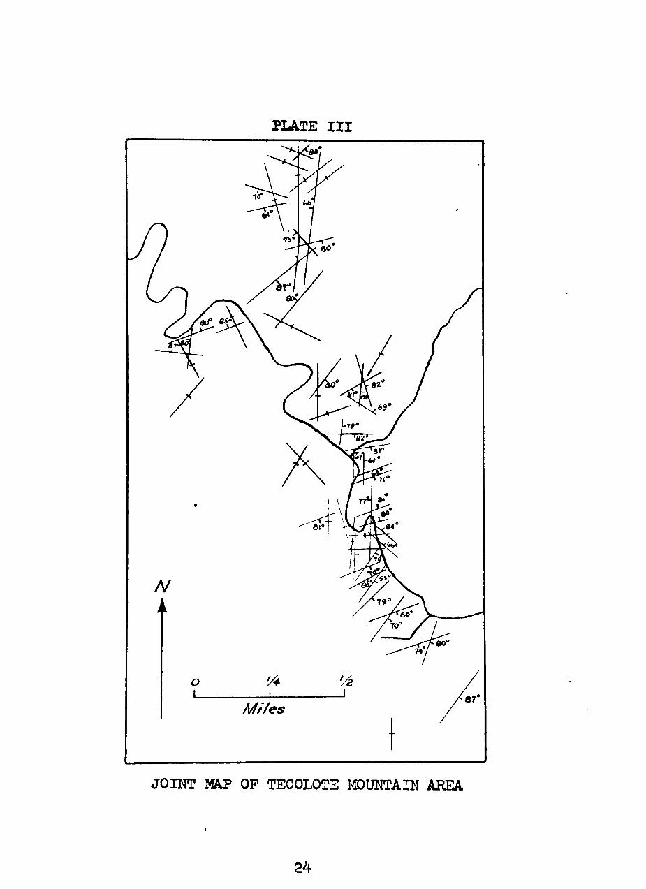
PLATE III
JOHÎT M P OP TECOLOTE MOUNTAIN AREA
24
PLATE IV
F/g. <3 ~Jo//?t D/a^râm of Pennsy/i/â/?/â/? fPcc/cs
W.
F/^. b '"^o/ntD/^^a//? of Per/r^/cin-Cretciceous /?oc/cs S<ôt/e 11 11 I 1 I 11 I 111 £âch cíiVÍsion c<fua/s one jotnt
JOIUT DIAGRAMS
25
26
NIOQE Jo in t s sugr€sts these a l s o are Pennsylvanian, a l t h o u ^
P i g . b (Plîîte IV ) would indicate they are Laramide. The
perpendicu lar i ty of the Pennsylvanian and Laramide deforma-
t i o n s would probably produce some p a r a l l e l j o i n t s . The
w r i t e r b e l i e v e s that the north trending Jo ints were formed
by both Pennsylvanian and Laramide a c t i v i t y .
CIIAPTER I I I
GEOLOGIC HISTORY
The h i s t o r y of the region begins with igneous a c t i -
v i t y of supposed pre-Cambrian age . A major i n t e r v a l of
e r o s i o n occupied e a r l y and mlddle Paleozoic time . L i t t l e
e l s e i s known of the pre-Pennsylvanian h i s tory of northern
New Mexico. Several i s l a n d - l i k e p o s i t i v e areas projected
above the eroded pre-Cambrian surface during Pennsylvanian
t lme . These include the Zuni u p l i f t to the west , ths Un-
compahgre landmass and Sierra Grande arch to the north-
wes t , and the Pedernal a x l s to the southeas t .
The Tecolote Mountain area l i e s near tbe western
fr inge of the Pedernal a x i s in the rtowe-Mora Basin. Penn-
sy lvanian s trata here r e f l e c t a near-shore envlronment.
They have resu l ted from t y p i c a l Penneylvanian c y c l i c de-T7 p o s i t i o n . According to Young-^ , "Not l e s s than 68 cy-
clothems occur in the Cortado formation (Des lîoines age)
In the v i c i n i t y of Taos, New íAexico"^ Upl i r t of the
source areas and lowcring of the bas ins were the main
causes of the cyc lc thems.
Early Sandla seaa transgressed the basin areas , de-
p o a i t i n g t h i c k l l m e s t o n e s . Subsequent u p l i f t and eros ion
^"^ John A. Young, "Cyclothems, the Key to Lower Pennsylvanian Diastrophism in Northern New Mexlco", Geol. Soo. Am.. Bul. 57 , (1946) , p . 1246.
27
28
of the source areas in middle Sandia t ine were responsible
for the upper s e r i e s of c l a s t i c s . Late Sandia u p l i f t of
these axes and deepening of the Intervening trour-hs r e -
su l t ed i n geosync l ina l condit ions of depos i t i on in ear ly
Kadera t ime . Late Madera orkoses r e f l e c t u p l i f t of the
source areaa . Continued u p l i f t , a s soc ia ted with hor izonta l
shear ing , re su l t ed in the defornation of the Tecolote area
at the c lose of Magdalena t ime. Regional t i l t i n g accora^anied
the f o l d i n g . Thrust f a u l t i n g in ^^e southern part of the
area re su l t ed from continued app l i ca t ion of the shearing
s t r e s s e s . The angular r e l a t i o n s h i p of the 'lsgdalena rocka
to the over ly ing Sangre de Cristo formation i n d i c a t e s the
t i l t i n g was of rreater magnitude than i s indicated by t h e i r
present plunge • Since the Tecolote Mountain area i s s i tua ted
on the e a s t e r n edge of the Sangre de Cristo ant i c l inor ium,
the Laramlde f o l d i n g would tend to r e c t i f y the southwest
plunge of the Pennsylvanian rocks rather than increase i t .
An extended period of eros ion i s shown by the promin-
ent angular unconformity at the top of the Magdalena. Basin
d e p o s i t s of the Sanrre de Cris to formation grade upward to
platform sandstones in the upper Permian. Near-shore p l a t -
form condi t ions prevai led throurhout the Mesoeoic. Deposi-
t i o n had by now overlapped the ances t ra l uplands and broad,
a l l u v i a l p l a i n s probably e x i s t e d .
In l a t e Cretaceous age the sediir.ents in northern
29
New Mexico were subjected to g igant ic s t r e s s e s which folded
them i n t o the Sangre de Cristo ant i c l inor ium. Pennsyl-
vanian f o l d s i n the Teco ote area v/cre c r o s s - f o l d e d , and
a large norraal f a u l t further deformed the area .
Erosion of the ant ic l inor ium in Tert iary t ime,
fol lowed by subsequent u p l i f t and e r o s i o n , produced the
present reg ional physiography.
CONCLUSIONS
The Tecolote Mountain area has undergone two d i s t i n c t
per iods of deformation, Pennsylvanian and Cretaceous. The
former re su l t ed from a general ly north-south a c t l n g couple
accompanied by t i l t i n g . This f lexured the Pennsylvanian
sediments i n t o t i g h t northeast-southwest strikin<~ asymmetric-
a l f o l d s which are overthrust to the south. The folded
s t ra ta are separated from over ly ing arkosic redbeds by a
prominent angul r unconformity. Although the lowermost
redbeds are deemed to be Pennsylvanian in age , they are
s t r u c t u r a l l y a s soc ia ted with the Permian redbeds.
The l a t e r deformation occurred in l a t e Cretaceous
time and Is a s s o c i a t e d with the Laramide r e v o l u t i o n . As
a r e s u l t , the major structure in the Pennsylvanian of 1 he
Tecolote area i s a north-trending a n t i c l i n e plunging to the
south . S t r e s s e s a c t i n g in the Tecolote area were probably
shearing components of the reg iona l s t r e s s e s . Their general
path of a c t l o n was e a s t - w e s t . The true d i r e c t i o n i s not
determlnable , be lng a funct ion of the b r l t t l e n e s s of the
s t ra ta I t a f f e c t s . The a lready-fo lded Pennsylvanian rocks
were cross-foldfed and a l s o traversed by a major normal f a u l t
downthrown to the e a s t .
A study of the Jo in t s found in Pennsylvanian and
Permian-Cretaceous s trata revea l s Jo ints of d e f i n i t e
30
31
Pennsylvanian age s t r i k i n g N70^-80OE and N80O-90°W. Proni-
nent Jo in t s s t r i k i n g NIO^ to NIOOW are be l i eved to be of
both Pennsylvanian and Cretaceous age becauae the d i r e c t i o n s
of s t r e s s of the two deformations are perpendicular . In
f a c t , t h i s Joint trend may have been the plane of weakness
which permitted the major north-south f a u l t i n Cretaceous
time in the Tecolote area .
32
EXPLANATION 0!? PL->TE V
Pip:* a . Looking c^st toward Tecolote ?íountain. Strata dipping to northwest are thrust over the c r o s s -bedded Madera sandstone to south. The fau l t has a higji angle and s t r i k e s nearly In l ine with the telephone p o l e s . Tecolote Creek i s in the foreground. In the small t r ibutary ( r i g h t , rear) raay be seen unconformable northeas t -d lpping Permian redbeds.
Pift* h . Looking north at same outcrops as above . Prominent conjugate Jo ints and cross-bedded nature of the l lmestone are s e e n . Rocks in l e f t background are thrust over those i n the foreground.
P i g , c , Looking eas t from a point south of the bend in Tecolote Creek in P i g . a . Rldges in background and f l a t land in front of them are Permlan Sangre de Cr l s to formation. Madera limestone in foreground.
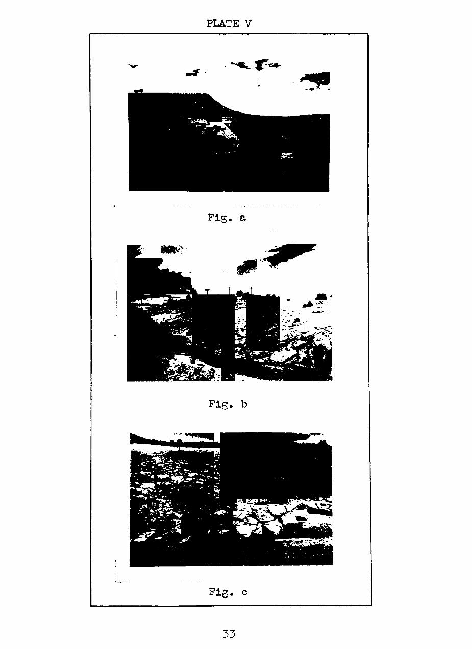
PLATE V
33
34
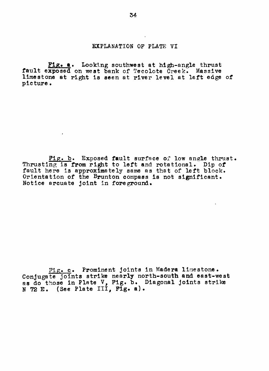
EXPLANATION OP PLATE VI
Flg» a . Looking southwest at h i ^ - a n g l e thrust f a u l t exposed on west bank of Tecolote Creek. Massive l imestone at r ight i s seen at r iver l e v e l at l e f t edge of p i c t u r e .
Pip;. b . Exposed f a u l t surface of low angle t h r u s t . Thrusting i s from r i g h t to l e f t and r o t a t i o n a l . Dip of f a u l t here i s approximately same as that of l e f t b lock . Orientat ion of the Brunton compass i s not s i g n i f i c a n t . Notice arcuate Joint in foreground.
P i g . c . Prominent Jo ints i n Madera l i n e s t o n e . Conjugate j o i n t a s tr ike nearly north-south and eas t -wes t as do those in Plnte V, P i g . b . Diagonal Jo lnts s tr ike N 72 E . (See Plate I I I , P i g . a ) .
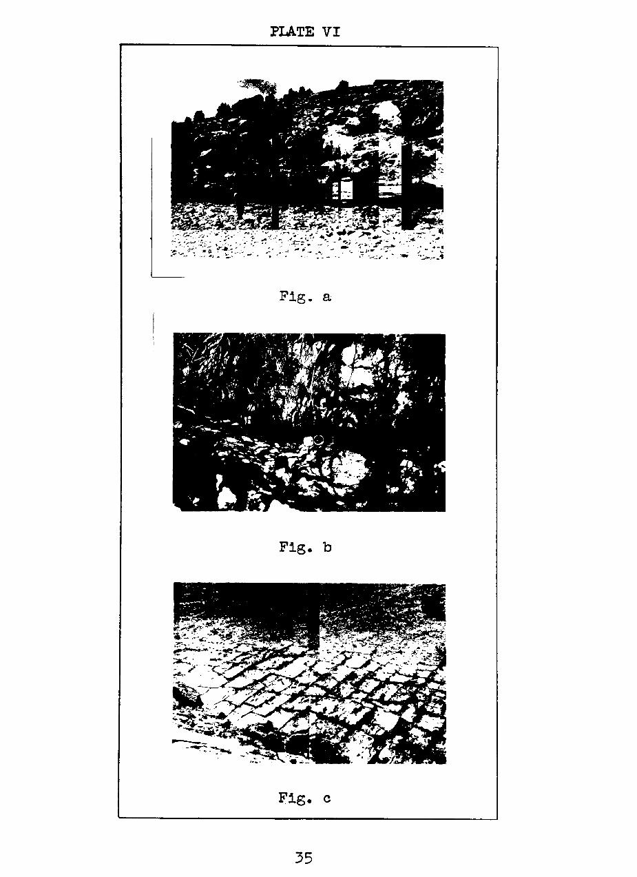
PLATE VI
-•'•c^r'y,y-''.V.--
FlS- a
Pig. b
Flg. c
35
36
EXPLANATION OP PLATE VII
Pify. a . Looking northeast at s t eep ly dippinf; Madera l imestone beds Just south of the stream Juncture where the major normal f a u l t i s crossed by Tecolote Creek. (See Plate X ) . The massive gray l imestone in the center of the p ic ture i s approximately 15 f ee t t h l c k . I t I s a l so seen a t extreme l e f t of P i g . a, Plate VIII .
Pif^. b . Looking southwest from the rim of the f i r s t large meander in Tecolote Creek northwest of Gabal-don. Tecolote Creek bed Is approxlmately 100 f e e t below. An a n t i c l i n e can be seen in the west bank. Rocks at the creek l e v e l are upper Sandia in age , and those on the rim are Madera. Scarps in the background c o n s l s t of Sangre de Crlsto redbeds.
Fip;. c . Outcrop of " t r a n s i t i o n beds" at the e x -treme northern end of the area s t u d i e d . These rocks are very coarse arkoses and l i e unconfgrmably on Magdalena age r o c k s . They are considered upper Pennsylvanian in age but are s t r u c t u r a l l y a s s o c l a t e d with the Permian rocks of the Sangre de Cristo formation. P o s s i l evidence i s l a c k l n g for a d e f l n i t e determination of age of these r o c k s .
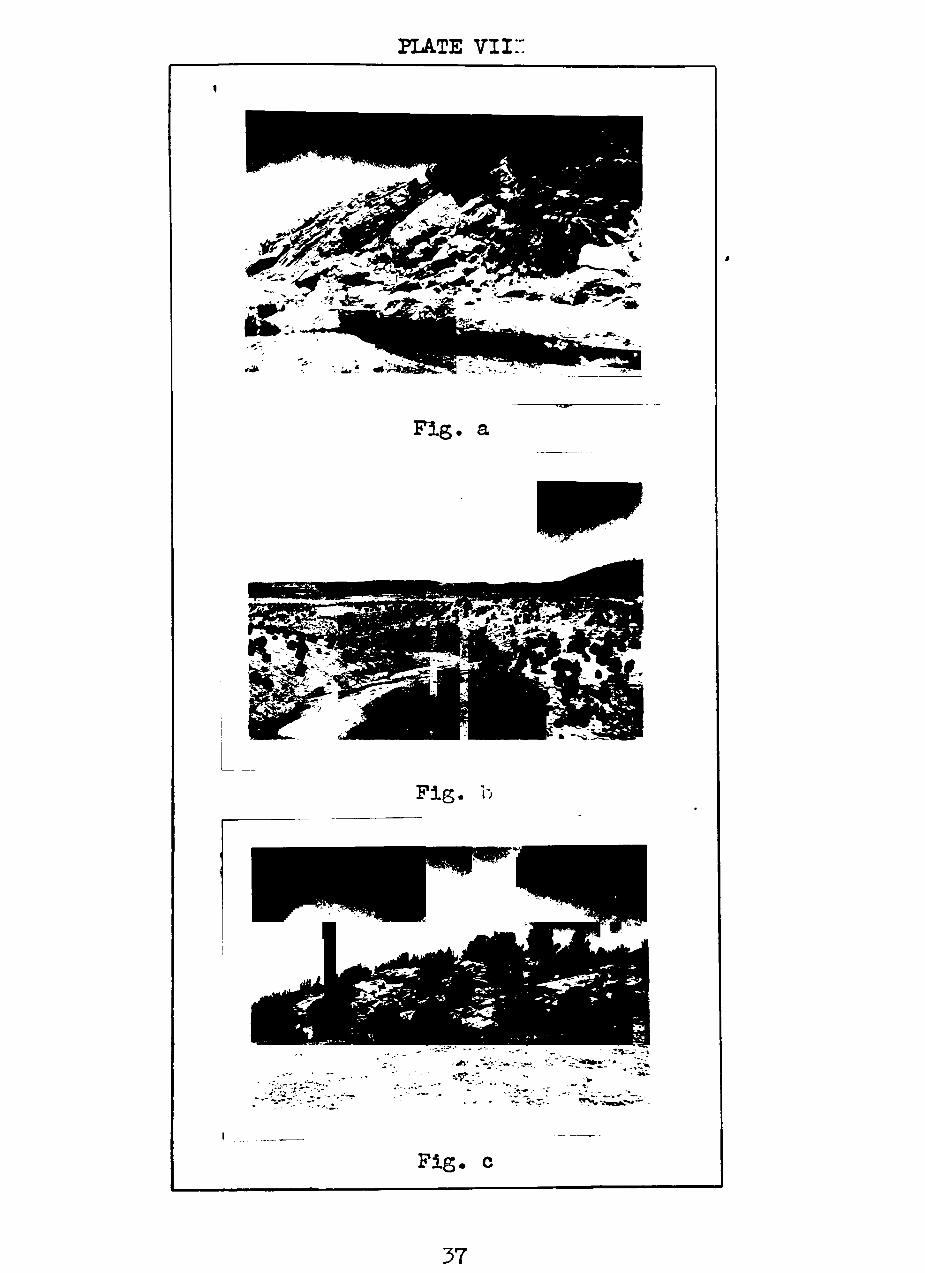
PLATE v i i : :
F l g . a
P i g . o
'^* » '" ^.-/
f ' . ' i •'.'•. WV,v„i^if««-'
F i g . c
37
38
EXPLANATION OP PL..TE VIII
Pip;* a . Looking south at stream bank p a r a l l e l t o s e c t i o n C-C». The major normal f a u l t of Cretaceous age i s seen here dipping about 45° to the e a s t . On the r i { ^ t are c l a s t i c s of Sandia age and on the l e f t are Madera l imestones The l e f t or eas t b lock i s thus seen to have dropped down r e l a t i v e to the west b lock . Careful inspec t ion of the Iron-stone layer at r l ^ t along the stream l e v e l shows mlnor f a u l t s (displacements of a few inches to one foo t ) wh'ch are d i r e c t evidence of the age r e l a t i o n s of the major f a u l t .
P i g . b . Looking eas t toward Tecolote Mountain. The stream Juncture Just south of Gabladon i s seen in the l e f t center port ion of the v lew. The major normal f a u l t in P i g . a s t r i k e s approximately p a r a l l e l to the stream bed at r ight and passes behlnd the f l a t - l y i n g s trata of Sandla age at l e f t . The l a t t e r are thus seen to be the upthrown b lock . The massive l imestones at r ight are of Madera age and r e -present the north limb of an asymmetrical fau l ted a n t i -c l i n e plunging toward the ohserver.
M M M >
a tJÛ •H &4
i -- /
^ • *
CO
M P»
O
3 < • — I
39
LãOEf^D
Sa/T^re c/e Cr/stc
/^c c/erdi
t^í^ Sanc/é /a
^ ^
UG/i/£>/t//>Sl/í/^c/ / \ . " A
,"0 A, ^
I ^ ^
I
c 5
^
^
<í 1 f 0 ^
^-
«0
H2
o
I
^
•ÍS-V 0»
C o
• ^
Ci
o >3
<3i ^ X • ^
t ^
,N
î?
®
.<0
y
/
y
r /
^-/7
V ^ -M UJ
<
o *
^
v
V V
\ \
X - . / \
V y \
r r'
\ • - ? ' •
/
_;LI
c^
•^
\
\
^
Y L».t
^ \
' í X
^ 'O
-íi
'' m '' \
'' '/ //«
'7 •
• a
.
y \
03
'^ -Í" ^
" ^ < : ^
———"
/
\
s
\
\
•,Vi \v--
V.'
V
Kí
^ o \
>
Ai,
^ \ X
>y '•/ ~ > y
/ ,k!
A H
,V
- < // \j
-X / î \ - ' ,
oû
® x - ^ - / " i.'-
'l
II II ••
Jí ll
II II
II
II II
ll
\ J i s
fí® \
//
// //
// IJ.-^' ^
y
/y
/
//\^
''/ •^'
/y
X
^/
yy /
/
/
r
I ./
./
^
LU í -<:
•/.^^
m
>.íL_
f '-:Í<--'\
/U/ o o
' • « .
-to u
íO
I
î: o
.S
I-
li V
I-
II
5: ,0 s. Ho
'0 •j
z o h-o u
LU
h-
BIBLIOGRAPHY
B i l l l n g s , Marland P . , S tructural Geology, (New York: P r e n t i c e - H a l l , I n c , 1942) .
Gordon, C. H. , "Notes on the Pennsylvanian Pcrmations in the Rio Grande Va l l ey , New I'exico", Jour. of Geolory. Vol . XV, ( 1 9 0 7 ) .
Herrick, C. L . , "Geology of the White Sands of lîew Mexico'*, Jour. of GeoloCT-. Vol . VII I , ( 1900) .
Keyes, C. R. , "Oeological Skstches of New Mexico", Ores and Meta ls , Vol . XII , (1905) .
Mead, Warren J . , "Notes on the Mechanics of Geolo^ric S t m c t -ures" , Jour. of Geology. Vol . XXVIII, (1920) .
Nevin, C. M., Pr inc ip lea of Structural Geolofq-^ (4th e d . ; New York: John Wiley & Sons, I n c . , 1949)•
Plttman, Gardner M., Pennsylvanian Stratipraphy of Tecolote Area. New Mexico. Unpubllshed Master's T h e s i s . Texas Technologlcal Co l l ege , (1951) .
Read, C. 3 . e t a l . y Geolopiical Map and Strat lpyaphic Sections qf Permian and Pennsylvanian Rocka i n Parts of San Mipnel. Santa Fe, Sandoval. B e r n a l i l l o . Torrance. and Valencia Counties . North Central New Mexico. U. â. Dept. I n t . , Geol. Surv . , Oil and Gas I n v e s t i g a t i o n , Preliminary Map 2 1 , (1944) .
S i d w e l l , Raymond, "Sediments at the Southern Termination of the Sangre de Cristo Antlcl inorium", Jour. of Sedinen-tarv Petro logy . Vol . XVIII, No. 3 , ( 1 9 4 8 ) .
W l l l i s , Ba i ley and W i l l i s , Robin, Geologic Structvires . (3rd. e d . ; New Yorkj McGraw-Hill Co. , 1934) .
Young, John A . , J r . , "Cyclothems, the Key to Lower Pennsyl-vanian Diastrophism In Northern New Mexico", Geol. S o c i e t y of America. Bul . 57 , (1946) .
41