Embed Size (px)
Citation preview
6th Grade Modern World Studies Frameworks for the Georgia Standards of Excellence in Social Studies
Georgia Department of Education THIS WORK IS LICENSED UNDER A CREATIVE C OMMONS ATTRIBUTION - NONCOMMERCIAL - SHAREALIKE 4.0 INTERNATIONAL LICENSE
7.17.2018 Page 1 of 47
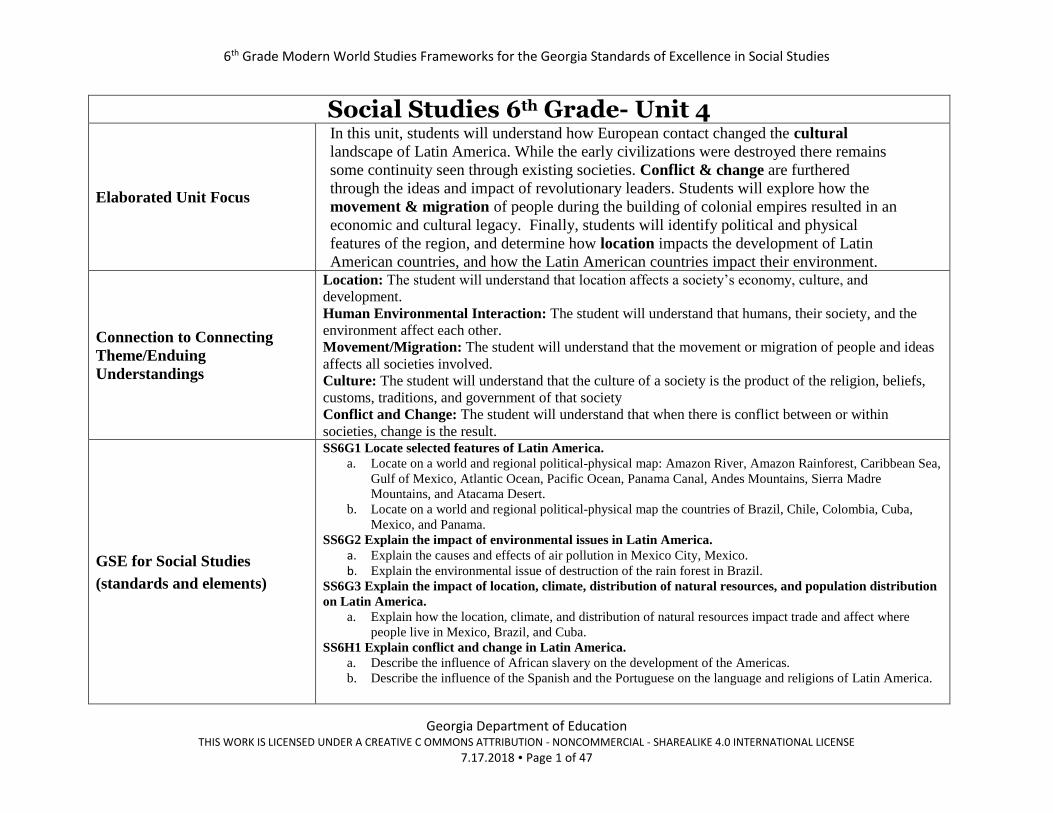
Social Studies 6th Grade- Unit 4
Elaborated Unit Focus
In this unit, students will understand how European contact changed the cultural
landscape of Latin America. While the early civilizations were destroyed there remains
some continuity seen through existing societies. Conflict & change are furthered
through the ideas and impact of revolutionary leaders. Students will explore how the
movement & migration of people during the building of colonial empires resulted in an
economic and cultural legacy. Finally, students will identify political and physical
features of the region, and determine how location impacts the development of Latin
American countries, and how the Latin American countries impact their environment.
Connection to Connecting
Theme/Enduing
Understandings
Location: The student will understand that location affects a society’s economy, culture, and
development.
Human Environmental Interaction: The student will understand that humans, their society, and the
environment affect each other.
Movement/Migration: The student will understand that the movement or migration of people and ideas
affects all societies involved.
Culture: The student will understand that the culture of a society is the product of the religion, beliefs,
customs, traditions, and government of that society
Conflict and Change: The student will understand that when there is conflict between or within
societies, change is the result.
GSE for Social Studies
(standards and elements)
SS6G1 Locate selected features of Latin America.
a. Locate on a world and regional political-physical map: Amazon River, Amazon Rainforest, Caribbean Sea,
Gulf of Mexico, Atlantic Ocean, Pacific Ocean, Panama Canal, Andes Mountains, Sierra Madre
Mountains, and Atacama Desert.
b. Locate on a world and regional political-physical map the countries of Brazil, Chile, Colombia, Cuba,
Mexico, and Panama.
SS6G2 Explain the impact of environmental issues in Latin America.
a. Explain the causes and effects of air pollution in Mexico City, Mexico. b. Explain the environmental issue of destruction of the rain forest in Brazil.
SS6G3 Explain the impact of location, climate, distribution of natural resources, and population distribution
on Latin America.
a. Explain how the location, climate, and distribution of natural resources impact trade and affect where
people live in Mexico, Brazil, and Cuba.
SS6H1 Explain conflict and change in Latin America.
a. Describe the influence of African slavery on the development of the Americas.
b. Describe the influence of the Spanish and the Portuguese on the language and religions of Latin America.

6th Grade Modern World Studies Frameworks for the Georgia Standards of Excellence in Social Studies
Georgia Department of Education THIS WORK IS LICENSED UNDER A CREATIVE C OMMONS ATTRIBUTION - NONCOMMERCIAL - SHAREALIKE 4.0 INTERNATIONAL LICENSE
7.17.2018 Page 2 of 47
Connection to Literacy
Standards for Social
Standards (reading and /or
writing)
Reading Skills
L6-8RHSS1: Cite specific textual evidence to support analysis of primary and secondary
sources.
L6-8RHSS7: Integrate visual information (e.g., in charts, graphs, photographs, videos, or maps)
with other information in print and digital texts.
Writing Skills
L6-8WHST4: Produce clear and coherent writing in which the development, organization, and
style are appropriate to task, purpose, and audience. L6-8WHST7: Conduct short research projects to answer a question (including a self-generated question),
drawing on several sources and generating additional related, focused questions that allow for multiple
avenues of exploration.
L6-8WHST9: Draw evidence from informational texts to support analysis reflection, and research.
Connection to Social Studies
Matrices (information
processing and/or map and
globe skills)
Map and Globe Skills
6. use map key/legend to acquire information from historical, physical, political, resource,
product, and economic maps.
7. use a map to explain impact of geography on historical and current events.
8. draw conclusions and make generalizations based on information from maps
10. compare maps of the same place at different points in time and from different perspectives to
determine changes, identify trends, and generalize about human activities.
11. compare maps with data sets (charts, tables, graphs) and /or readings to draw conclusions
and make generalizations.
Information Processing Skills 6. identify and use primary and secondary sources.
11. Draw conclusions and make generalizations.
6th Grade Modern World Studies Frameworks for the Georgia Standards of Excellence in Social Studies
Georgia Department of Education THIS WORK IS LICENSED UNDER A CREATIVE C OMMONS ATTRIBUTION - NONCOMMERCIAL - SHAREALIKE 4.0 INTERNATIONAL LICENSE
7.17.2018 Page 3 of 47
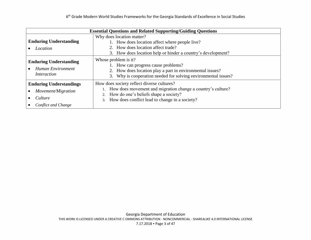
Essential Questions and Related Supporting/Guiding Questions
Enduring Understanding
• Location
Why does location matter?
1. How does location affect where people live?
2. How does location affect trade?
3. How does location help or hinder a country’s development?
Enduring Understanding
• Human Environment
Interaction
Whose problem is it?
1. How can progress cause problems?
2. How does location play a part in environmental issues?
3. Why is cooperation needed for solving environmental issues?
Enduring Understandings
• Movement/Migration
• Culture
• Conflict and Change
How does society reflect diverse cultures?
1. How does movement and migration change a country’s culture?
2. How do one’s beliefs shape a society?
3. How does conflict lead to change in a society?

6th Grade Modern World Studies Frameworks for the Georgia Standards of Excellence in Social Studies
Georgia Department of Education THIS WORK IS LICENSED UNDER A CREATIVE C OMMONS ATTRIBUTION - NONCOMMERCIAL - SHAREALIKE 4.0 INTERNATIONAL LICENSE
7.17.2018 Page 4 of 47
Sample Instructional Activities/Assessments
Where Am I?
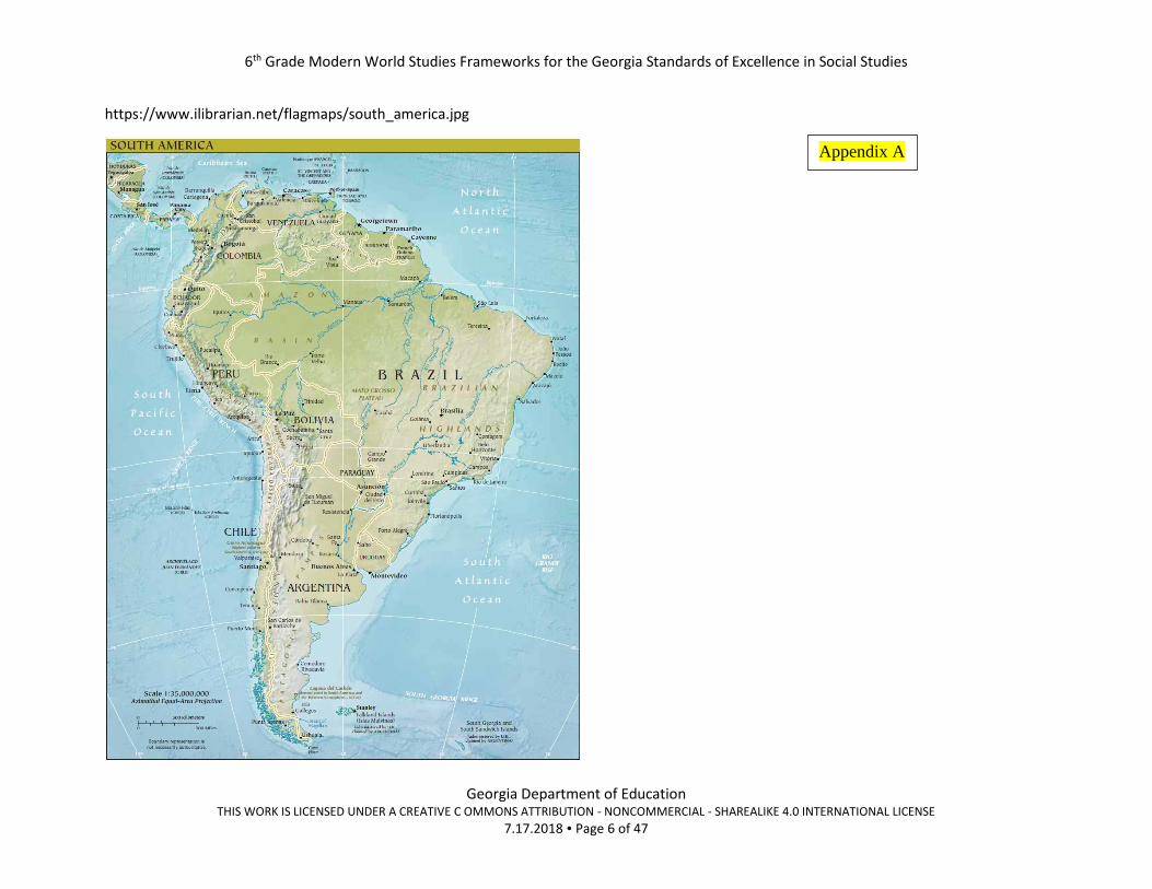
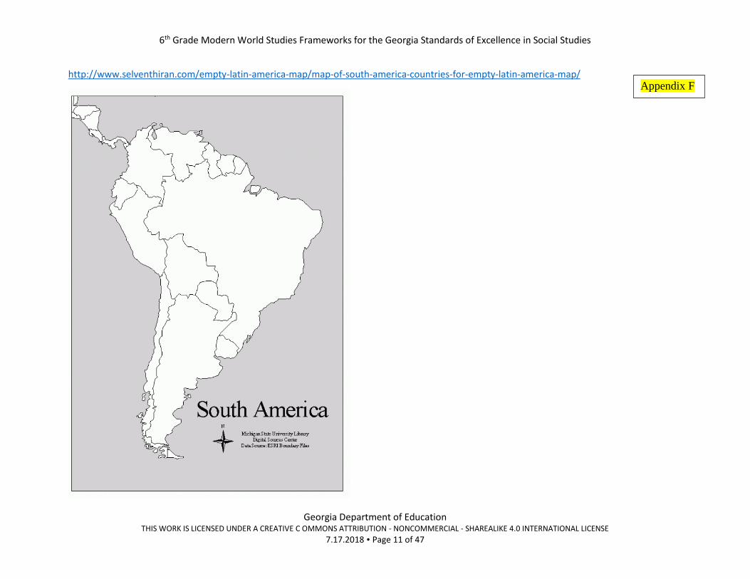
1. Using the political and physical maps, have students label the countries and features in the elements.
a. Physical Maps – Appendix A – C
b. Political Maps - Appendix D - H
Extension Ideas: (Choose one or provide as a choice for students.)
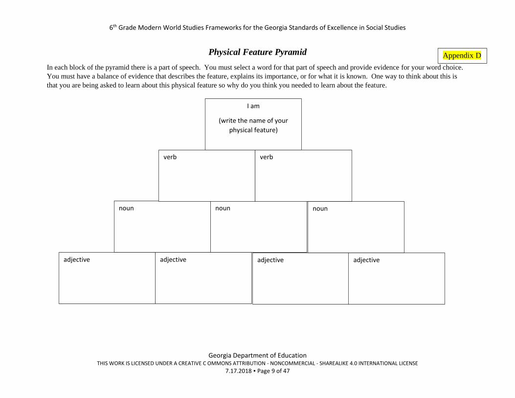
1. Have students work in groups and assign one of the physical features. Have them research their physical feature to provide a
brief overview of the feature by completing the Physical Feature pyramid. Students can create these on larger sheets of paper.
You can give each group 10 pieces of blank paper and a large sheet of paper to create a large version of the pyramid. By
doing it this way group members can work on pyramid pieces at the same time. (Appendix D)
2. Be the thing – Students will imagine that they are the physical feature and write a description of “themselves” as the feature.
They must have a balance of evidence that describes the feature, explains its importance, or for what it known. One way to
think about this is that students are being asked to learn about this physical feature so why do they think they need to learn
about the feature. Their response should be at least 2 paragraphs.
GSE Standards and
Elements
SS6G1 Locate selected features of Latin America.
a. Locate on a world and regional political-physical map: Amazon River, Amazon Rainforest,
Caribbean Sea, Gulf of Mexico, Atlantic Ocean, Pacific Ocean, Panama Canal, Andes
Mountains, Sierra Madre Mountains, and Atacama Desert.
b. Locate on a world and regional political-physical map the countries of Brazil, Chile, Colombia,
Cuba, Mexico, and Panama.
Literacy Standards
Reading Skills
L6-8RHSS1: Cite specific textual evidence to support analysis of primary and secondary sources.
L6-8RHSS7: Integrate visual information (e.g., in charts, graphs, photographs, videos, or maps) with
other information in print and digital texts.
Writing Skills
L6-8WHST4: Produce clear and coherent writing in which the development, organization, and style
are appropriate to task, purpose, and audience. L6-8WHST7: Conduct short research projects to answer a question (including a self-generated question), drawing on
several sources and generating additional related, focused questions that allow for multiple avenues of exploration.
L6-8WHST9: Draw evidence from informational texts to support analysis reflection, and research.
6th Grade Modern World Studies Frameworks for the Georgia Standards of Excellence in Social Studies
Georgia Department of Education THIS WORK IS LICENSED UNDER A CREATIVE C OMMONS ATTRIBUTION - NONCOMMERCIAL - SHAREALIKE 4.0 INTERNATIONAL LICENSE
7.17.2018 Page 5 of 47
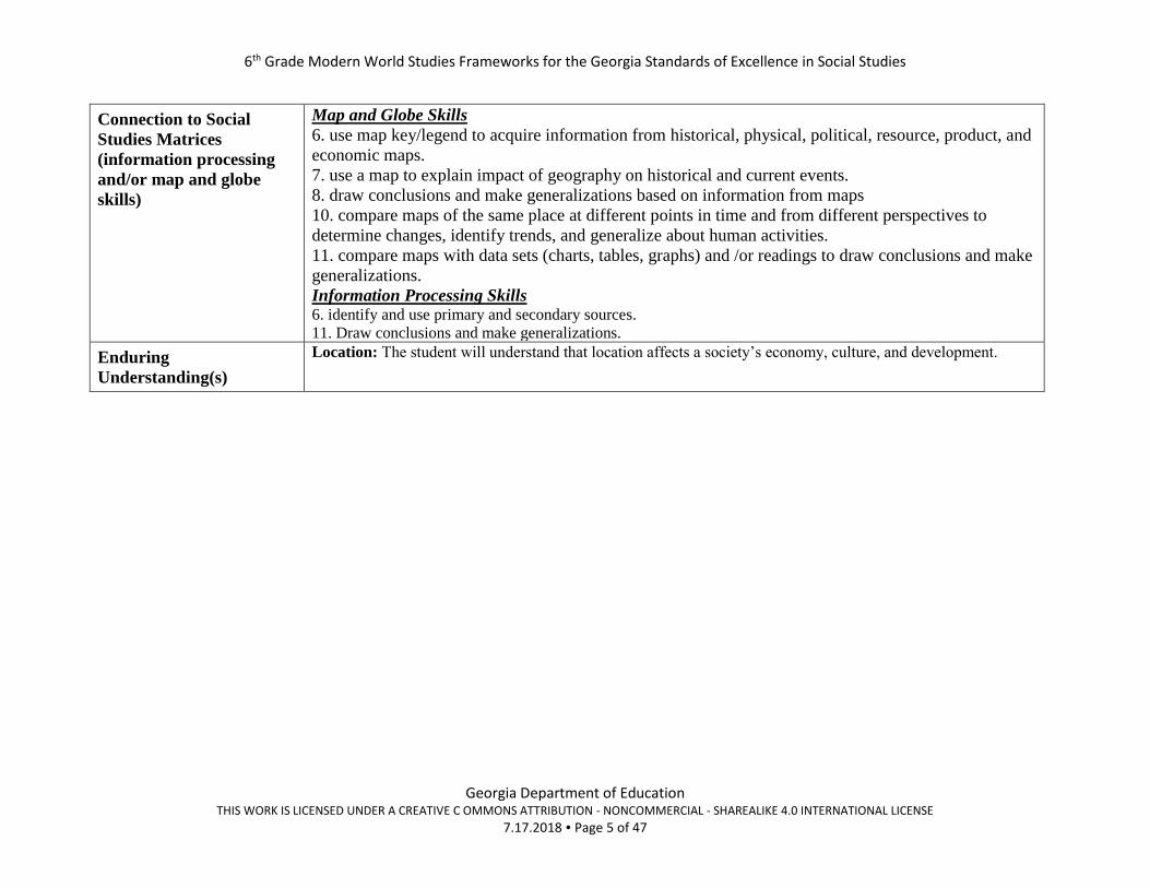
Connection to Social
Studies Matrices
(information processing
and/or map and globe
skills)
Map and Globe Skills
6. use map key/legend to acquire information from historical, physical, political, resource, product, and
economic maps.
7. use a map to explain impact of geography on historical and current events.
8. draw conclusions and make generalizations based on information from maps
10. compare maps of the same place at different points in time and from different perspectives to
determine changes, identify trends, and generalize about human activities.
11. compare maps with data sets (charts, tables, graphs) and /or readings to draw conclusions and make
generalizations.
Information Processing Skills 6. identify and use primary and secondary sources.
11. Draw conclusions and make generalizations.
Enduring
Understanding(s)
Location: The student will understand that location affects a society’s economy, culture, and development.
6th Grade Modern World Studies Frameworks for the Georgia Standards of Excellence in Social Studies
Georgia Department of Education THIS WORK IS LICENSED UNDER A CREATIVE C OMMONS ATTRIBUTION - NONCOMMERCIAL - SHAREALIKE 4.0 INTERNATIONAL LICENSE
7.17.2018 Page 6 of 47
https://www.ilibrarian.net/flagmaps/south_america.jpg
Appendix A

6th Grade Modern World Studies Frameworks for the Georgia Standards of Excellence in Social Studies
Georgia Department of Education THIS WORK IS LICENSED UNDER A CREATIVE C OMMONS ATTRIBUTION - NONCOMMERCIAL - SHAREALIKE 4.0 INTERNATIONAL LICENSE
7.17.2018 Page 7 of 47
http://www.maps-world.net/central-america.htm
Appendix B

6th Grade Modern World Studies Frameworks for the Georgia Standards of Excellence in Social Studies
Georgia Department of Education THIS WORK IS LICENSED UNDER A CREATIVE C OMMONS ATTRIBUTION - NONCOMMERCIAL - SHAREALIKE 4.0 INTERNATIONAL LICENSE
7.17.2018 Page 8 of 47
http://jeffreycollins.us/south-america-map-blank/south-america-map-blank-lovely-south-america-physical-features-map-blank-volgogradnews-
me-in/
Appendix C
6th Grade Modern World Studies Frameworks for the Georgia Standards of Excellence in Social Studies
Georgia Department of Education THIS WORK IS LICENSED UNDER A CREATIVE C OMMONS ATTRIBUTION - NONCOMMERCIAL - SHAREALIKE 4.0 INTERNATIONAL LICENSE
7.17.2018 Page 9 of 47
Physical Feature Pyramid
In each block of the pyramid there is a part of speech. You must select a word for that part of speech and provide evidence for your word choice.
You must have a balance of evidence that describes the feature, explains its importance, or for what it is known. One way to think about this is
that you are being asked to learn about this physical feature so why do you think you needed to learn about the feature.
adjective adjective adjective adjective
noun noun noun
verb verb
I am
(write the name of your
physical feature)
Appendix D

6th Grade Modern World Studies Frameworks for the Georgia Standards of Excellence in Social Studies
Georgia Department of Education THIS WORK IS LICENSED UNDER A CREATIVE C OMMONS ATTRIBUTION - NONCOMMERCIAL - SHAREALIKE 4.0 INTERNATIONAL LICENSE
7.17.2018 Page 10 of 47
http://www.selventhiran.com/empty-latin-america-map/south-america-map-no-labels-rip4l-awesome-blank-central-for-of-with-empty-latin-
america-map/
Appendix E
6th Grade Modern World Studies Frameworks for the Georgia Standards of Excellence in Social Studies
Georgia Department of Education THIS WORK IS LICENSED UNDER A CREATIVE C OMMONS ATTRIBUTION - NONCOMMERCIAL - SHAREALIKE 4.0 INTERNATIONAL LICENSE
7.17.2018 Page 11 of 47
http://www.selventhiran.com/empty-latin-america-map/map-of-south-america-countries-for-empty-latin-america-map/
Appendix F
6th Grade Modern World Studies Frameworks for the Georgia Standards of Excellence in Social Studies
Georgia Department of Education THIS WORK IS LICENSED UNDER A CREATIVE C OMMONS ATTRIBUTION - NONCOMMERCIAL - SHAREALIKE 4.0 INTERNATIONAL LICENSE
7.17.2018 Page 12 of 47
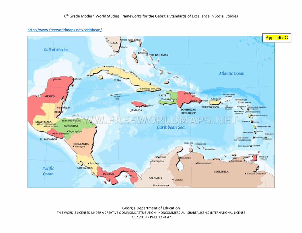
http://www.freeworldmaps.net/caribbean/
Appendix G

6th Grade Modern World Studies Frameworks for the Georgia Standards of Excellence in Social Studies
Georgia Department of Education THIS WORK IS LICENSED UNDER A CREATIVE C OMMONS ATTRIBUTION - NONCOMMERCIAL - SHAREALIKE 4.0 INTERNATIONAL LICENSE
7.17.2018 Page 13 of 47
http://www.freeworldmaps.net/southamerica/political.html
Appendix H
6th Grade Modern World Studies Frameworks for the Georgia Standards of Excellence in Social Studies
Georgia Department of Education THIS WORK IS LICENSED UNDER A CREATIVE C OMMONS ATTRIBUTION - NONCOMMERCIAL - SHAREALIKE 4.0 INTERNATIONAL LICENSE
7.17.2018 Page 14 of 47
Sample Instructional Activities/Assessments
How can there be a balance between development and damage to the environment?
The link below is to a lab on the sixth-grade resource page. Teachers can choose to do the complete lab or select resources and
activities from the lab.
https://www.georgiastandards.org/Georgia-Standards/Documents/Social-Studies-6th-Grade-Environmental-Issues-Latin-America-
Social-Studies-Lab.pdf
GSE Standards and
Elements
SS6G2 Explain the impact of environmental issues in Latin America.
a. Explain the causes and effects of air pollution in Mexico City, Mexico. b. Explain the environmental issue of destruction of the rain forest in Brazil.
Literacy Standards
Reading Skills
Writing Skills
Connection to Social
Studies Matrices
(information processing
and/or map and globe
skills)
Map and Globe Skills
Information Processing Skills
Enduring
Understanding(s)
See lab
See lab
See lab
6th Grade Modern World Studies Frameworks for the Georgia Standards of Excellence in Social Studies
Georgia Department of Education THIS WORK IS LICENSED UNDER A CREATIVE C OMMONS ATTRIBUTION - NONCOMMERCIAL - SHAREALIKE 4.0 INTERNATIONAL LICENSE
7.17.2018 Page 15 of 47
Sample Instructional Activities/Assessments
Why does location matter?
Where do people live?
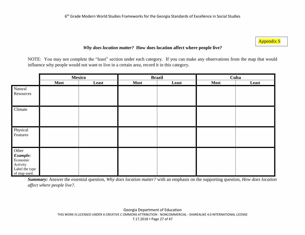
For the countries of Mexico and Brazil, give students the set of maps and population chart. (Appendix I – R). NOTE: If you do not
want to print colored copies of the maps, you can use the source set PowerPoint and display maps. Also, if you have a class set of
atlases you could use maps from the atlas.
1. Have them analyze the maps to determine the areas that are more heavily populated and least populated. Have students
complete the graphic organizer. (Appendix S)
2. Summary: Have students answer the essential question, Why does location matter? with an emphasis on the supporting
question, How does location affect where people live?.
Trade
Students will use the same maps from Where do people live? to complete the trade portion of this lesson. Directions are listed in
Appendix T. The organizer to record their analysis is Appendix U.
NOTE: The extra information for step 5 of the direction is located in Appendix V – X.
GSE Standards and
Elements
SS6G3 Explain the impact of location, climate, distribution of natural resources, and population
distribution on Latin America.
a. Explain how the location, climate, and distribution of natural resources impact trade and affect
where people live in Mexico, Brazil, and Cuba.
Literacy Standards
Reading Skills
L6-8RHSS1: Cite specific textual evidence to support analysis of primary and secondary sources.
L6-8RHSS7: Integrate visual information (e.g., in charts, graphs, photographs, videos, or maps) with
other information in print and digital texts.
Writing Skills
L6-8WHST4: Produce clear and coherent writing in which the development, organization, and style
are appropriate to task, purpose, and audience. L6-8WHST7: Conduct short research projects to answer a question (including a self-generated question), drawing on
several sources and generating additional related, focused questions that allow for multiple avenues of exploration.
L6-8WHST9: Draw evidence from informational texts to support analysis reflection, and research.

6th Grade Modern World Studies Frameworks for the Georgia Standards of Excellence in Social Studies
Georgia Department of Education THIS WORK IS LICENSED UNDER A CREATIVE C OMMONS ATTRIBUTION - NONCOMMERCIAL - SHAREALIKE 4.0 INTERNATIONAL LICENSE
7.17.2018 Page 16 of 47
Connection to Social
Studies Matrices
(information processing
and/or map and globe
skills)
Map and Globe Skills
6. use map key/legend to acquire information from historical, physical, political, resource, product, and
economic maps.
7. use a map to explain impact of geography on historical and current events.
8. draw conclusions and make generalizations based on information from maps
10. compare maps of the same place at different points in time and from different perspectives to
determine changes, identify trends, and generalize about human activities.
11. compare maps with data sets (charts, tables, graphs) and /or readings to draw conclusions and make
generalizations.
Information Processing Skills 6. identify and use primary and secondary sources.
11. Draw conclusions and make generalizations.
Enduring
Understanding(s)
Location: The student will understand that location affects a society’s economy, culture, and development.

6th Grade Modern World Studies Frameworks for the Georgia Standards of Excellence in Social Studies
Georgia Department of Education THIS WORK IS LICENSED UNDER A CREATIVE C OMMONS ATTRIBUTION - NONCOMMERCIAL - SHAREALIKE 4.0 INTERNATIONAL LICENSE
7.17.2018 Page 17 of 47
https://legacy.lib.utexas.edu/maps/americas/brazil_econ_1977.jpg
Brazil Economic Activity Appendix I
6th Grade Modern World Studies Frameworks for the Georgia Standards of Excellence in Social Studies
Georgia Department of Education THIS WORK IS LICENSED UNDER A CREATIVE C OMMONS ATTRIBUTION - NONCOMMERCIAL - SHAREALIKE 4.0 INTERNATIONAL LICENSE
7.17.2018 Page 18 of 47
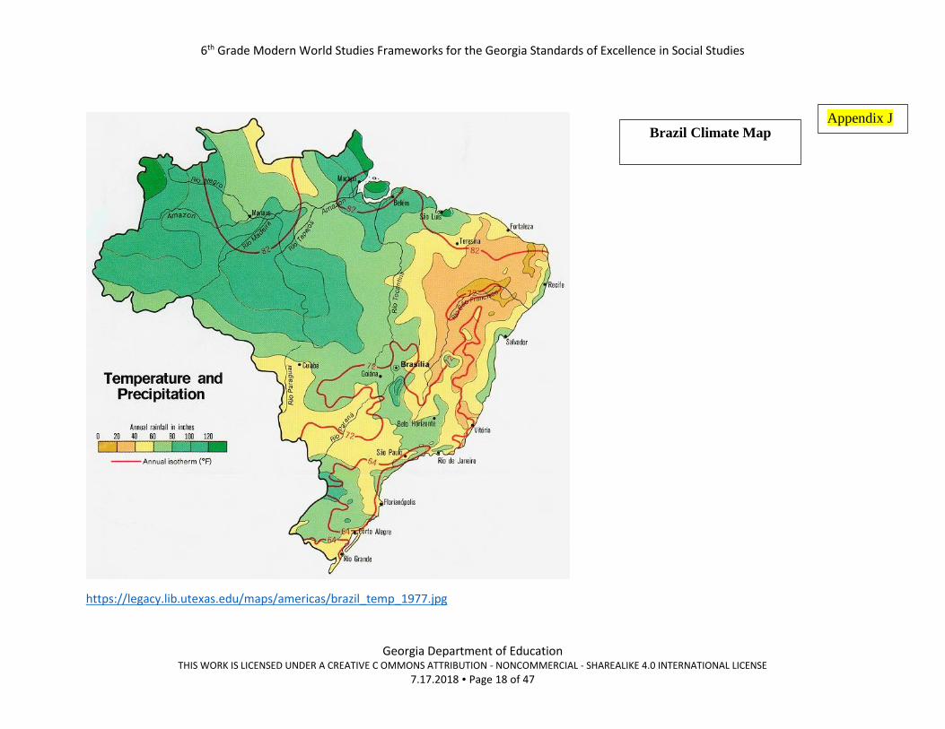
https://legacy.lib.utexas.edu/maps/americas/brazil_temp_1977.jpg
Brazil Climate Map Appendix J

6th Grade Modern World Studies Frameworks for the Georgia Standards of Excellence in Social Studies
Georgia Department of Education THIS WORK IS LICENSED UNDER A CREATIVE C OMMONS ATTRIBUTION - NONCOMMERCIAL - SHAREALIKE 4.0 INTERNATIONAL LICENSE
7.17.2018 Page 19 of 47
http://www.socioeconomicatlas.rs.gov.br/demographic-distribution-and-density
Brazil Population Map Appendix K

6th Grade Modern World Studies Frameworks for the Georgia Standards of Excellence in Social Studies
Georgia Department of Education THIS WORK IS LICENSED UNDER A CREATIVE C OMMONS ATTRIBUTION - NONCOMMERCIAL - SHAREALIKE 4.0 INTERNATIONAL LICENSE
7.17.2018 Page 20 of 47
https://trader2trader.co/2012/12/10/mexico-resources-mining-industry-map/
Appendix L

6th Grade Modern World Studies Frameworks for the Georgia Standards of Excellence in Social Studies
Georgia Department of Education THIS WORK IS LICENSED UNDER A CREATIVE C OMMONS ATTRIBUTION - NONCOMMERCIAL - SHAREALIKE 4.0 INTERNATIONAL LICENSE
7.17.2018 Page 21 of 47
https://maps-mexico-mx.com/mexico-population-distribution-map
Appendix M

6th Grade Modern World Studies Frameworks for the Georgia Standards of Excellence in Social Studies
Georgia Department of Education THIS WORK IS LICENSED UNDER A CREATIVE C OMMONS ATTRIBUTION - NONCOMMERCIAL - SHAREALIKE 4.0 INTERNATIONAL LICENSE
7.17.2018 Page 22 of 47
http://zeihan.com/wp-content/uploads/2015/12/272c-Mexican_Land_Use_R11-29-01-1024x850.jpg
Appendix N
6th Grade Modern World Studies Frameworks for the Georgia Standards of Excellence in Social Studies
Georgia Department of Education THIS WORK IS LICENSED UNDER A CREATIVE C OMMONS ATTRIBUTION - NONCOMMERCIAL - SHAREALIKE 4.0 INTERNATIONAL LICENSE
7.17.2018 Page 23 of 47
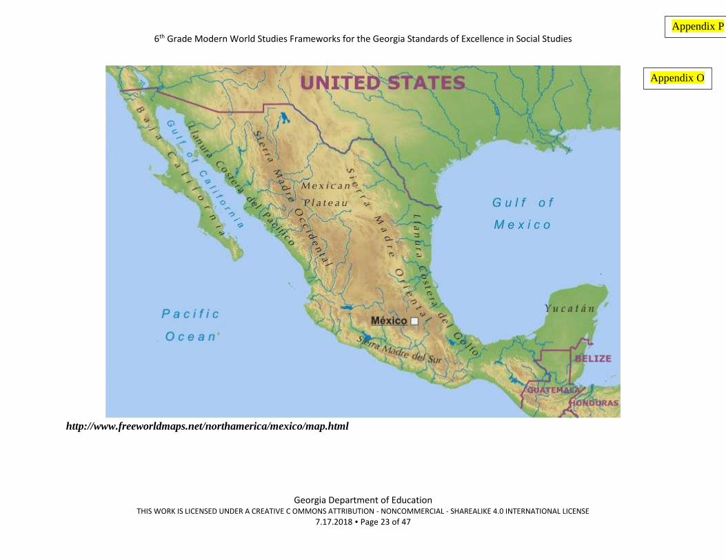
http://www.freeworldmaps.net/northamerica/mexico/map.html
Appendix O
Appendix P

6th Grade Modern World Studies Frameworks for the Georgia Standards of Excellence in Social Studies
Georgia Department of Education THIS WORK IS LICENSED UNDER A CREATIVE C OMMONS ATTRIBUTION - NONCOMMERCIAL - SHAREALIKE 4.0 INTERNATIONAL LICENSE
7.17.2018 Page 24 of 47
https://legacy.lib.utexas.edu/maps/americas/cuba_econ_1977.jpg
Cuba Economic Activity Map Appendix P

6th Grade Modern World Studies Frameworks for the Georgia Standards of Excellence in Social Studies
Georgia Department of Education THIS WORK IS LICENSED UNDER A CREATIVE C OMMONS ATTRIBUTION - NONCOMMERCIAL - SHAREALIKE 4.0 INTERNATIONAL LICENSE
7.17.2018 Page 25 of 47
https://www.ezilon.com/maps/north-america/cuba-physical-maps.html
Cuba Physical Map Appendix Q

6th Grade Modern World Studies Frameworks for the Georgia Standards of Excellence in Social Studies
Georgia Department of Education THIS WORK IS LICENSED UNDER A CREATIVE C OMMONS ATTRIBUTION - NONCOMMERCIAL - SHAREALIKE 4.0 INTERNATIONAL LICENSE
7.17.2018 Page 26 of 47
https://www.worldatlas.com/articles/the-biggest-cities-in-cuba.html
The Biggest Cities In Cuba
Rank Biggest Cities in Cuba Population
1 Havana 2,106,146
2 Santiago de Cuba 509,143
3 Holguín 346,191
4 Camagüey 321,992
5 Santa Clara 242,402
6 Bayamo 222,118
7 Guantánamo 210,407
8 Las Tunas 171,957
9 Cienfuegos 164,924
10 Pinar del Río 154,107
Appendix R
6th Grade Modern World Studies Frameworks for the Georgia Standards of Excellence in Social Studies
Georgia Department of Education THIS WORK IS LICENSED UNDER A CREATIVE C OMMONS ATTRIBUTION - NONCOMMERCIAL - SHAREALIKE 4.0 INTERNATIONAL LICENSE
7.17.2018 Page 27 of 47
Why does location matter? How does location affect where people live?
NOTE: You may not complete the “least” section under each category. If you can make any observations from the map that would
influence why people would not want to live in a certain area, record it in this category.
Mexico Brazil Cuba Most Least Most Least Most Least
Natural
Resources
Climate
Physical
Features
Other
Example: Economic
Activity
Label the type
of map used.
Summary: Answer the essential question, Why does location matter? with an emphasis on the supporting question, How does location
affect where people live?.
Appendix S

6th Grade Modern World Studies Frameworks for the Georgia Standards of Excellence in Social Studies
Georgia Department of Education THIS WORK IS LICENSED UNDER A CREATIVE C OMMONS ATTRIBUTION - NONCOMMERCIAL - SHAREALIKE 4.0 INTERNATIONAL LICENSE
7.17.2018 Page 28 of 47
SS6G3 Explain the impact of location, climate, distribution of natural resources, and population distribution on Latin America.
b. Explain how the location, climate, and distribution of natural resources impact trade and affect where people live in Mexico, Brazil, and Cuba.
Direction for “Trade” Analysis
Step 1:
Using the maps introduced in the “Where People Live” section, have students complete the “Trade Predictions” organizer.
Step 2:
Once they have made their predictions, have students go the The World Factbook — Central Intelligence Agency - CIA
https://www.cia.gov/library/publications/the-world-factbook/ to check their predictions. Once they get to the site, have
students use the drop-down menu and select the countries: Mexico, Brazil and Cuba . They can scroll down to the Economic
section to see trading partners and items for export.
Step 3:
Students will make other connections using the information on the World Factbook site: Agriculture products, Industries.
Students can make connections to this information to export
Step 4:
Have students go to the transportation section for each country. Have them scroll down to find important information about
transportation that will impact trade (major waterways, ports, etc.) Use this information and the physical features map to
determine possible trade routes for the countries they are trading partners.
o Example:
▪ Railways: note about carriers for industries, waterways, merchant marines ports and terminals.
Step 5:
Students can use the extra information provided to further validate their predictions.
Summary: Have students answer the essential question and supporting question, Why does location matter? How does location
affect trade?
Appendix T

6th Grade Modern World Studies Frameworks for the Georgia Standards of Excellence in Social Studies
Georgia Department of Education THIS WORK IS LICENSED UNDER A CREATIVE C OMMONS ATTRIBUTION - NONCOMMERCIAL - SHAREALIKE 4.0 INTERNATIONAL LICENSE
7.17.2018 Page 29 of 47
Trade Predictions– Mexico, Brazil, Cuba
Using the maps provided in the activity on population density, complete the prediction statements about trade in these countries.
Mexico Brazil Cuba
Physical Map:
What features may help or
hinder trade?
Natural Resources:
What do you think the
county might export?
Climate:
Do you think climate will
affect trade in this country?
Explain.
Location:
What are possible trade
routes for this country?
Who do you think might be
their trading partners?
Other observations
Summary: Have students answer the essential question and supporting question, Why does location matter? How does location
affect trade?
Appendix U
6th Grade Modern World Studies Frameworks for the Georgia Standards of Excellence in Social Studies
Georgia Department of Education THIS WORK IS LICENSED UNDER A CREATIVE C OMMONS ATTRIBUTION - NONCOMMERCIAL - SHAREALIKE 4.0 INTERNATIONAL LICENSE
7.17.2018 Page 30 of 47
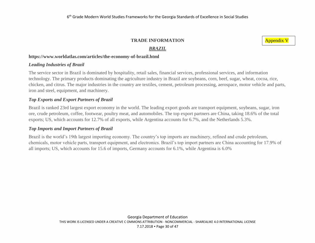
TRADE INFORMATION
BRAZIL
https://www.worldatlas.com/articles/the-economy-of-brazil.html
Leading Industries of Brazil
The service sector in Brazil is dominated by hospitality, retail sales, financial services, professional services, and information
technology. The primary products dominating the agriculture industry in Brazil are soybeans, corn, beef, sugar, wheat, cocoa, rice,
chicken, and citrus. The major industries in the country are textiles, cement, petroleum processing, aerospace, motor vehicle and parts,
iron and steel, equipment, and machinery.
Top Exports and Export Partners of Brazil
Brazil is ranked 23rd largest export economy in the world. The leading export goods are transport equipment, soybeans, sugar, iron
ore, crude petroleum, coffee, footwear, poultry meat, and automobiles. The top export partners are China, taking 18.6% of the total
exports; US, which accounts for 12.7% of all exports, while Argentina accounts for 6.7%, and the Netherlands 5.3%.
Top Imports and Import Partners of Brazil
Brazil is the world’s 19th largest importing economy. The country’s top imports are machinery, refined and crude petroleum,
chemicals, motor vehicle parts, transport equipment, and electronics. Brazil’s top import partners are China accounting for 17.9% of
all imports; US, which accounts for 15.6 of imports, Germany accounts for 6.1%, while Argentina is 6.0%
Appendix V
6th Grade Modern World Studies Frameworks for the Georgia Standards of Excellence in Social Studies
Georgia Department of Education THIS WORK IS LICENSED UNDER A CREATIVE C OMMONS ATTRIBUTION - NONCOMMERCIAL - SHAREALIKE 4.0 INTERNATIONAL LICENSE
7.17.2018 Page 31 of 47
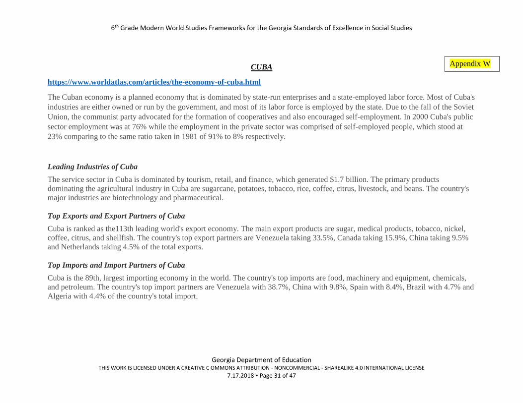
CUBA
https://www.worldatlas.com/articles/the-economy-of-cuba.html
The Cuban economy is a planned economy that is dominated by state-run enterprises and a state-employed labor force. Most of Cuba's
industries are either owned or run by the government, and most of its labor force is employed by the state. Due to the fall of the Soviet
Union, the communist party advocated for the formation of cooperatives and also encouraged self-employment. In 2000 Cuba's public
sector employment was at 76% while the employment in the private sector was comprised of self-employed people, which stood at
23% comparing to the same ratio taken in 1981 of 91% to 8% respectively.
Leading Industries of Cuba
The service sector in Cuba is dominated by tourism, retail, and finance, which generated $1.7 billion. The primary products
dominating the agricultural industry in Cuba are sugarcane, potatoes, tobacco, rice, coffee, citrus, livestock, and beans. The country's
major industries are biotechnology and pharmaceutical.
Top Exports and Export Partners of Cuba
Cuba is ranked as the113th leading world's export economy. The main export products are sugar, medical products, tobacco, nickel,
coffee, citrus, and shellfish. The country's top export partners are Venezuela taking 33.5%, Canada taking 15.9%, China taking 9.5%
and Netherlands taking 4.5% of the total exports.
Top Imports and Import Partners of Cuba
Cuba is the 89th, largest importing economy in the world. The country's top imports are food, machinery and equipment, chemicals,
and petroleum. The country's top import partners are Venezuela with 38.7%, China with 9.8%, Spain with 8.4%, Brazil with 4.7% and
Algeria with 4.4% of the country's total import.
Appendix W

6th Grade Modern World Studies Frameworks for the Georgia Standards of Excellence in Social Studies
Georgia Department of Education THIS WORK IS LICENSED UNDER A CREATIVE C OMMONS ATTRIBUTION - NONCOMMERCIAL - SHAREALIKE 4.0 INTERNATIONAL LICENSE
7.17.2018 Page 32 of 47
MEXICO
https://www.worldatlas.com/articles/the-economy-of-mexico.html
Leading Industries of Mexico
The leading industry of Mexico is the services sector, which contributes 59.8% of the GDP. The industry sector contributes 36.6%,
followed by agriculture with 3.6% (significantly lower than its employment rate). The leading industry products include: tobacco,
chemicals, electronics, iron and steel, aerospace, textiles, mining, and petroleum.
Top Export Goods and Partners of Mexico
In 2014, exports from Mexico were valued at $400 billion, making it the 12th largest export economy in the world. Its principal
exports include: crude petroleum ($37 billion), cars ($33 billion), vehicle parts ($23 billion), delivery trucks ($22.7 billion), and
computers ($18.6 billion). A large percentage of its exports go to the following countries: the United States ($291 billion), Canada
($24.5 billion), China ($7.89 billion), Spain ($6.18 billion), and Brazil ($5.35 billion).
Top Import Goods and Partners of Mexico
In 2014, imports to Mexico totaled $379 billion, giving this country a positive trade balance of $21.3 billion. A positive trade balance
means the country exported more than it imported. Its major imports include: refined petroleum ($22.9 billion), vehicle parts ($22.7
billion), integrated circuits ($13.5 billion), computers ($10 billion), and broadcasting accessories ($8.98 billion). A large portion of its
imports come from the following countries: the US ($194 billion), China ($58.7 billion), Japan ($15.8 billion), South Korea ($13.4
billion), and Germany ($12.8 billion).
Appendix X

6th Grade Modern World Studies Frameworks for the Georgia Standards of Excellence in Social Studies
Georgia Department of Education THIS WORK IS LICENSED UNDER A CREATIVE C OMMONS ATTRIBUTION - NONCOMMERCIAL - SHAREALIKE 4.0 INTERNATIONAL LICENSE
7.17.2018 Page 33 of 47
Sample Instructional Activities/Assessments
Predictions Please! What are my elements?
Students can work in partners or groups of 4.
PART 1
1. Show students the standard SS6H1 Explain conflict and change in Latin America. Do Not show the elements. Explain to
students that they have to solve the puzzle of what are the 2 elements under this standard. You can set it up something like
this:
a. Post the standard only on the board. Tell students today this is the standard that they are to master. However, there
are some pieces missing. We are not sure what is the change and conflict that we are to learn. Some documents
have been left to analyze that will help us solve our puzzle. (You may need to post previous standard and elements
to review the purpose of the elements.)
2. Provide students with the information chart of the countries of Latin America and the maps. (Appendix Y – BB) (You
may want to give one to each group member or if students are working with a partner, assign 2 per partner.)
3. Have them analyze the information to make predictions about what is the conflict and change they are supposed to learn.
4. Have students complete the document analysis and prediction chart. (Appendix CC)
5. Have students write what they think element A and B might be. Have them write the evidence to support their responses.
6. Have students share. (You could have a couple of groups share.)
PART 2
1. Explain to students that they are going to be given reading selections that will provide more information. Two students will
get Reading A and the other partnership will get Reading B. They will use the selective highlighting strategy as they read.
They will highlight anything that could be conflict in one color and anything that is change in another color.
2. Each pair will share their findings.
3. Students can change their predictions if needed based on the new information.
4. Give each group 2 sentence strips. Have them write their predictions on the sentence strips – one for element A and another
for element B. Also, have them write the evidence that supports their predictions. OR Give them large sheets of paper and
have them write their responses.
5. Post these in the room.
PART 3
1. Explain to students that they are going to view other students’ work. They should look for:
a. Similarities in topics
b. Something they really like
6th Grade Modern World Studies Frameworks for the Georgia Standards of Excellence in Social Studies
Georgia Department of Education THIS WORK IS LICENSED UNDER A CREATIVE C OMMONS ATTRIBUTION - NONCOMMERCIAL - SHAREALIKE 4.0 INTERNATIONAL LICENSE
7.17.2018 Page 34 of 47
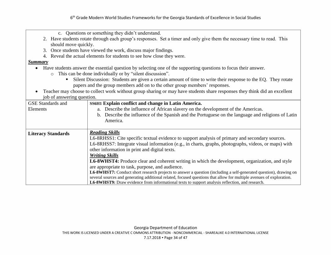
c. Questions or something they didn’t understand.
2. Have students rotate through each group’s responses. Set a timer and only give them the necessary time to read. This
should move quickly.
3. Once students have viewed the work, discuss major findings.
4. Reveal the actual elements for students to see how close they were.
Summary
• Have students answer the essential question by selecting one of the supporting questions to focus their answer.
o This can be done individually or by “silent discussion”.
▪ Silent Discussion: Students are given a certain amount of time to write their response to the EQ. They rotate
papers and the group members add on to the other group members’ responses.
• Teacher may choose to collect work without group sharing or may have students share responses they think did an excellent
job of answering question.
GSE Standards and
Elements
SS6H1 Explain conflict and change in Latin America.
a. Describe the influence of African slavery on the development of the Americas.
b. Describe the influence of the Spanish and the Portuguese on the language and religions of Latin
America.
Literacy Standards
Reading Skills
L6-8RHSS1: Cite specific textual evidence to support analysis of primary and secondary sources.
L6-8RHSS7: Integrate visual information (e.g., in charts, graphs, photographs, videos, or maps) with
other information in print and digital texts.
Writing Skills
L6-8WHST4: Produce clear and coherent writing in which the development, organization, and style
are appropriate to task, purpose, and audience. L6-8WHST7: Conduct short research projects to answer a question (including a self-generated question), drawing on
several sources and generating additional related, focused questions that allow for multiple avenues of exploration.
L6-8WHST9: Draw evidence from informational texts to support analysis reflection, and research.

6th Grade Modern World Studies Frameworks for the Georgia Standards of Excellence in Social Studies
Georgia Department of Education THIS WORK IS LICENSED UNDER A CREATIVE C OMMONS ATTRIBUTION - NONCOMMERCIAL - SHAREALIKE 4.0 INTERNATIONAL LICENSE
7.17.2018 Page 35 of 47
Connection to Social
Studies Matrices
(information processing
and/or map and globe
skills)
Map and Globe Skills
6. use map key/legend to acquire information from historical, physical, political, resource, product, and
economic maps.
7. use a map to explain impact of geography on historical and current events.
8. draw conclusions and make generalizations based on information from maps
10. compare maps of the same place at different points in time and from different perspectives to
determine changes, identify trends, and generalize about human activities.
11. compare maps with data sets (charts, tables, graphs) and /or readings to draw conclusions and make
generalizations.
Information Processing Skills 6. identify and use primary and secondary sources.
11. Draw conclusions and make generalizations.
Enduring
Understanding(s)
Movement/Migration: The student will understand that the movement or migration of people and ideas affects
all societies involved.
Culture: The student will understand that the culture of a society is the product of the religion, beliefs, customs,
traditions, and government of that society
Conflict and Change: The student will understand that when there is conflict between or within societies,
change is the result.

6th Grade Modern World Studies Frameworks for the Georgia Standards of Excellence in Social Studies
Georgia Department of Education THIS WORK IS LICENSED UNDER A CREATIVE C OMMONS ATTRIBUTION - NONCOMMERCIAL - SHAREALIKE 4.0 INTERNATIONAL LICENSE
7.17.2018 Page 36 of 47
http://www.freeman-pedia.com/latin-american-independence/ http://www.justmaps.org/maps/thematics/religions.asp
Appendix Y
MAPS

6th Grade Modern World Studies Frameworks for the Georgia Standards of Excellence in Social Studies
Georgia Department of Education THIS WORK IS LICENSED UNDER A CREATIVE C OMMONS ATTRIBUTION - NONCOMMERCIAL - SHAREALIKE 4.0 INTERNATIONAL LICENSE
7.17.2018 Page 37 of 47
https://en.wikipedia.org/wiki/Triangular_trade#/media/File:Triangle_trade2.png
Triangular Trade
Appendix Z

6th Grade Modern World Studies Frameworks for the Georgia Standards of Excellence in Social Studies
Georgia Department of Education THIS WORK IS LICENSED UNDER A CREATIVE C OMMONS ATTRIBUTION - NONCOMMERCIAL - SHAREALIKE 4.0 INTERNATIONAL LICENSE
7.17.2018 Page 38 of 47
https://www.sutori.com/item/map-of-the-columbian-exchange
The Columbian Exchange
Appendix AA

6th Grade Modern World Studies Frameworks for the Georgia Standards of Excellence in Social Studies
Georgia Department of Education THIS WORK IS LICENSED UNDER A CREATIVE C OMMONS ATTRIBUTION - NONCOMMERCIAL - SHAREALIKE 4.0 INTERNATIONAL LICENSE
7.17.2018 Page 39 of 47
Latin American Countries – Religion and Language
Helpful Hint: Focus for religion analysis: Under the religion column, look for common religions for the highest percent.
❖ Information in this chart is from https://www.cia.gov/library/publications/the-world-factbook/
Country Religion Language
Argentina Roman Catholic 92% (less than 20% practicing), Protestant 2%,
Jewish 2%, other 4%
Spanish (official)
Belize Roman Catholic 40.1%, Protestant 31.5% Jehovah's Witness
1.7%, other 10.5% (2010 est.)
English 62.9% (official)
Bolivia Roman Catholic 76.8%, Evangel ical and Pentecostal 8.1%,
Protestant 7.9%, other 1.7%, none 5.5% (2012 est.)
Spanish (official) 60.7%, Quechua (official) 21.2%, Aymara
(official) 14.6, Guarani (official) note: Bolivia 's 2009
constitution designates Spanish and all indigenous languages a s
official; 36 indigenous languages are specified, including some
that are extinct (2001 est.)
Brazil Roman Catholic 64.6%, other Catholic 0.4%, Protestant 22.2%
Portuguese (official and most widely spoken language)
Chile Roman Catholic 66.7%, Evangelical or Protestant 16.4%,
Jehovah's Witnesses 1%, other 3.4%, (2012 est.)
Spanish 99.5% (official)
Columbia Roman Catholic 90%, other 10% Spanish (official)
Costa Rica Roman Catholic 76.3%, Evangelical 13.7%, Jehovah's Witnesses
1.3%, other Protestant 0.7%, other 4.8%, none 3.2%
Spanish (official)
Cuba nominally Roman Catholic 85%,
note: prior to CASTRO assuming power
Spanish (official)
Dominican
Republic
Roman Catholic 95%, other 5% Spanish (official
Ecuador Roman Catholic 74%, Evangelical 10.4%, Je hovah's Witness
1.2%, other 6.4% note: data represents persons at least 16 years
of age from five Ecuadoran cities (2012 est.)
Spanish (official)
El Salvador Roman Catholic 57.1%, Protestant 21.2%, Jehovah's Witnesses
1.9%, Mormon 0.7%, other religions 2.3%, none 16.8% (2003
est.)
Spanish (official)
Guatemala Roman Catholic, Protestant, indigenous Mayan beliefs Spanish (official)
Guyana Protestant 30.5%, Hindu 28.4%, Roman Catholic 8.1%, Muslim
7.2%, Jehovah's Witness 1.1%, other Christian 17.7%, other
1.9%, none 4.3%, unspecified 0.9% (2002 est.)
English (official)
Haiti Roman Catholic (official) 54.7%, Protestant 28.5% French (official), Creole (official)
Honduras Roman Catholic 97%, Protestant 3% Spanish (official)
Appendix BB

6th Grade Modern World Studies Frameworks for the Georgia Standards of Excellence in Social Studies
Georgia Department of Education THIS WORK IS LICENSED UNDER A CREATIVE C OMMONS ATTRIBUTION - NONCOMMERCIAL - SHAREALIKE 4.0 INTERNATIONAL LICENSE
7.17.2018 Page 40 of 47
Country Religion Language
Jamaica Protestant 64.8% Roman Catholic 2.2%, other 6.5%, none
21.3%, unspecified 2.3% (2011 est.) English
Mexico Roman Catholic 82.7%, Pentecostal 1.6%, Jehovah's Witnesses
1.4%, other Evangelical Churches 5%, other 1.9%, none 4.7%,
unspecified 2.7% (2010 est.)
Spanish
Nicaragua Roman Catholic 58.5%, Protestant 23.2% Jehovah's Witnesses
0.9%, other 1.6%, none 15.7% (2005 est.)
Spanish (official)
Panama Roman Catholic 85%, Protestant 15% Spanish (official)
Paraguay Roman Catholic 89.6%, Protestant 6.2%, other Christian 1.1%,
other or unspecified 1.9%, none 1.1% (2002 census)
Spanish (official), Guarani (official)
Peru Roman Catholic 81.3%, Evangelical 12.5%, other 3.3%, none
2.9% (2007 est.)
Spanish (official) 84.1%, Quechua (official)
Suriname Hindu 27.4%, Protestant 25.2% Roman Catholic 22.8%, Muslim
19.6%, indigenous beliefs 5%
Dutch (official)
Uruguay Roman Catholic 47.1%, non-Catholic Christians 11.1%,
nondenominational 23.2%, Jewish 0.3%, , other 1.1% (2006)
Spanish (official)
Venezuela Roman Catholic 96%, Protestant 2%, other 2% Spanish (official)

6th Grade Modern World Studies Frameworks for the Georgia Standards of Excellence in Social Studies
Georgia Department of Education THIS WORK IS LICENSED UNDER A CREATIVE C OMMONS ATTRIBUTION - NONCOMMERCIAL - SHAREALIKE 4.0 INTERNATIONAL LICENSE
7.17.2018 Page 41 of 47
R E A D I N G A h t t p s : / / w w w . b e r e a . e d u / c i e / f o c u s - l a t i n - a m e r i c a /
G e o g r a p h y
Latin America is a region in the Western Hemisphere, south of the United States. The term Latin America is used
to describe the countries in South America, Middle America, and the Caribbean that speak Latin languages, also
known as the “Romance languages.” These languages include Spanish, Portuguese, and French. Latin America
extends from Mexico in North America and down through Central America, parts of the Caribbean and all of South
America down to the bottom of the continent. While it is a very diverse region, the people of these countries share
similar historical experiences, languages and cultures.
H i s t o r y
Latin America came to fruition in the 1500’s after European “discovery” of the New World. Countries such as
Spain, France and Portugal colonized the region. Although most of Latin America was colonized by Spain, the
countries of Portugal and France also had major influences on the region. Due to war and disease, native
populations were decimated. The European countries’ demand for free labor led them to engage in the African
slave trade. Millions of Africans were brought over from Africa, which resulted in the African diaspora being so
prominent in Latin America. During the late 18th and early 19th century the people of Latin America began fighting
for independence. By 1898, all Latin American countries had become independent nations.
C u l t u r e
Latin America is a huge melting pot of different cultures. Indigenous, African, and European people make up the
bulk of this culture. As a result of intermixing, religions such as Santeria in Cuba, and Candomble in Brazil have
been created. These religions have African roots but also contain elements of European Catholicism. Another
example of intermixing can be found in Mexican son music. The term “Son” is given to a category of Mexican folk
music which covers a variety of styles that vary by region. However, these styles share a number of common
characteristics in their rhythms, lyrics, and dance. The music is a mix of Spanish, African, and indigenous
elements, which mingled at least as far back as the 18th century.
Appendix CC
6th Grade Modern World Studies Frameworks for the Georgia Standards of Excellence in Social Studies
Georgia Department of Education THIS WORK IS LICENSED UNDER A CREATIVE C OMMONS ATTRIBUTION - NONCOMMERCIAL - SHAREALIKE 4.0 INTERNATIONAL LICENSE
7.17.2018 Page 42 of 47
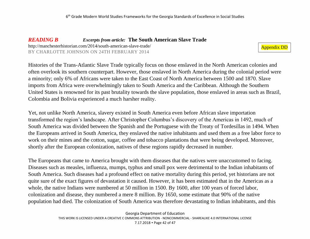
READING B Excerpts from article: The South American Slave Trade http://manchesterhistorian.com/2014/south-american-slave-trade/
BY CHARLOTTE JOHNSON ON 24TH FEBRUARY 2014
Histories of the Trans-Atlantic Slave Trade typically focus on those enslaved in the North American colonies and
often overlook its southern counterpart. However, those enslaved in North America during the colonial period were
a minority; only 6% of Africans were taken to the East Coast of North America between 1500 and 1870. Slave
imports from Africa were overwhelmingly taken to South America and the Caribbean. Although the Southern
United States is renowned for its past brutality towards the slave population, those enslaved in areas such as Brazil,
Colombia and Bolivia experienced a much harsher reality.
Yet, not unlike North America, slavery existed in South America even before African slave importation
transformed the region’s landscape. After Christopher Columbus’s discovery of the Americas in 1492, much of
South America was divided between the Spanish and the Portuguese with the Treaty of Tordesillas in 1494. When
the Europeans arrived in South America, they enslaved the native inhabitants and used them as a free labor force to
work on their mines and the cotton, sugar, coffee and tobacco plantations that were being developed. Moreover,
shortly after the European colonization, natives of these regions rapidly decreased in number.
The Europeans that came to America brought with them diseases that the natives were unaccustomed to facing.
Diseases such as measles, influenza, mumps, typhus and small pox were detrimental to the Indian inhabitants of
South America. Such diseases had a profound effect on native mortality during this period, yet historians are not
quite sure of the exact figures of devastation it caused. However, it has been estimated that in the Americas as a
whole, the native Indians were numbered at 50 million in 1500. By 1600, after 100 years of forced labor,
colonization and disease, they numbered a mere 8 million. By 1650, some estimate that 90% of the native
population had died. The colonization of South America was therefore devastating to Indian inhabitants, and this
Appendix DD

6th Grade Modern World Studies Frameworks for the Georgia Standards of Excellence in Social Studies
Georgia Department of Education THIS WORK IS LICENSED UNDER A CREATIVE C OMMONS ATTRIBUTION - NONCOMMERCIAL - SHAREALIKE 4.0 INTERNATIONAL LICENSE
7.17.2018 Page 43 of 47
loss has been described as one of the largest demographic disasters in human history. It was then when the
Europeans of South America turned to Africa for a new labor force to be the backbone of their agricultural
economy.
Today, the descendants of the Africans enslaved during this period still have a profound effect on the landscape of
Latin America. Indeed, the largest African population outside of Africa exists in Brazil. They have had
considerable influence in shaping the societies of Latin America. As in the United States, the Africans shipped to
South America in the colonial period brought with them many customs, religions, and traditions which contribute
to the culture that exists in these countries today. This can be seen most clearly when looking at religion. Religious
faiths that emerged from Africa and that still exist today – for example, Shango in Venezuela and Brazil – are no
longer just confined to people of African origin. Literature and the arts have also been greatly influenced by Africa.
Many poems and novels of Latin America show elements of African styles or concepts, which further demonstrates
a far-reaching cultural exchange. Whether these descendants of both free and enslaved Africans exist as a majority
or minority in Latin America today, their influence in these societies is still very much present.

6th Grade Modern World Studies Frameworks for the Georgia Standards of Excellence in Social Studies
Georgia Department of Education THIS WORK IS LICENSED UNDER A CREATIVE C OMMONS ATTRIBUTION - NONCOMMERCIAL - SHAREALIKE 4.0 INTERNATIONAL LICENSE
7.17.2018 Page 44 of 47
Document What I Observe Statement
Maps
Triangular Trade
Columbian Exchange
Latin American Countries:
Religion and Language
Our Predictions
Your because should be the evidence you gathered during your analysis of the documents.
SS6H1 Explain conflict and change in Latin America
We think element a is:
because
We think element b is:
because
Appendix EE

6th Grade Modern World Studies Frameworks for the Georgia Standards of Excellence in Social Studies
Georgia Department of Education THIS WORK IS LICENSED UNDER A CREATIVE C OMMONS ATTRIBUTION - NONCOMMERCIAL - SHAREALIKE 4.0 INTERNATIONAL LICENSE
7.17.2018 Page 45 of 47
Culminating Unit Performance Task
Come Visit! Travel Poster
Students will use their knowledge and resources to create a travel poster about Mexico, Cuba or Brazil.
NOTE: Students could choose other Latin American countries if the teacher wants to extend the assignment.
Students may create this using the computer or on poster paper.
The following is a list of sample requirements.
Requirements:
1. Graphics – Minimum of 5 – needs to represent factual information
2. Slogan – Come up with a creative slogan or title of why people should come to your country.
3. Information – You have learned about physical features, location, where people live, and culture. Incorporate this information
in your poster. Your information needs to be related to the essential questions: Why does location matter? and How does
society reflect a diverse culture?.
4. Overall Appearance – Creativity, neatness, etc.
Think about ways you can incorporate your information into your graphics. For example, if you are highlighting the Amazon River,
you may draw the river and put your information inside the river.
GSE Standards and Elements
SS6G1 Locate selected features of Latin America.
c. Locate on a world and regional political-physical map: Amazon River, Amazon Rainforest, Caribbean
Sea, Gulf of Mexico, Atlantic Ocean, Pacific Ocean, Panama Canal, Andes Mountains, Sierra Madre
Mountains, and Atacama Desert.
d. Locate on a world and regional political-physical map the countries of Brazil, Chile, Colombia, Cuba,
Mexico, and Panama.
SS6G3 Explain the impact of location, climate, distribution of natural resources, and population
distribution on Latin America.
c. Explain how the location, climate, and distribution of natural resources impact trade and affect where
people live in Mexico, Brazil, and Cuba.
SS6H1 Explain conflict and change in Latin America.
a. Describe the influence of African slavery on the development of the Americas. b. Describe the influence of the Spanish and the Portuguese on the language and religions of Latin America

6th Grade Modern World Studies Frameworks for the Georgia Standards of Excellence in Social Studies
Georgia Department of Education THIS WORK IS LICENSED UNDER A CREATIVE C OMMONS ATTRIBUTION - NONCOMMERCIAL - SHAREALIKE 4.0 INTERNATIONAL LICENSE
7.17.2018 Page 46 of 47
Literacy Standards
(Standards used depend upon the
choice of the activity.)
Reading Skills
L6-8RHSS2: Determine the central ideas or information of a primary or secondary source;
provide an accurate summary of the source distinct from prior knowledge or opinions.
L6-8RHSS4: Determine the meaning of words and phrases as they are used in a text, including
vocabulary specific to domains related to history/social studies.
L6-8RHSS7: Integrate visual information (e.g., in charts, graphs, photographs, videos, or
maps) with other information in print and digital texts.
Writing Skills
L6-8WHST2: Write informative/explanatory texts, including the narration of historical
events, scientific procedures/experiments, or technical processes.
a. Introduce a topic clearly, previewing what is to follow; organize ideas, concepts, and
information into broader categories as appropriate to achieving purpose; include
formatting (e.g., headings), graphics (e.g., charts, tables), and multimedia when useful
to aiding comprehension.
b. Develop the topic with relevant, well-chosen facts, definitions, concrete details,
quotations, or other information and examples.
c. Use precise language and domain-specific vocabulary to inform about or explain the
topic.
L6-8WHST9: Draw evidence from informational texts to support analysis reflection, and
research.
Social Studies Matrices
(Standards used depend upon the
choice of the activity.)
Map Skills
4.compare and contrast the categories of natural, cultural, and political features found on maps
7. use a map to explain impact of geography on historical and current events
10. compare maps of the same place at different points in time and from different perspectives to
determine changes, identify trends, and generalize about human activities
11. compare maps with data sets (charts, tables, graphs) and /or readings to draw conclusions and make
generalizations.
Informational/Processing Skills 6. identify and use primary and secondary sources
11. draw conclusions and make generalizations
15. determine adequacy and/or relevancy of information
6th Grade Modern World Studies Frameworks for the Georgia Standards of Excellence in Social Studies
Georgia Department of Education THIS WORK IS LICENSED UNDER A CREATIVE C OMMONS ATTRIBUTION - NONCOMMERCIAL - SHAREALIKE 4.0 INTERNATIONAL LICENSE
7.17.2018 Page 47 of 47
Enduring Understanding(s) Location: The student will understand that location affects a society’s economy, culture, and
development.
Human Environmental Interaction: The student will understand that humans, their society, and the
environment affect each other.
Movement/Migration: The student will understand that the movement or migration of people and ideas
affects all societies involved.
Culture: The student will understand that the culture of a society is the product of the religion, beliefs,
customs, traditions, and government of that society
Conflict and Change: The student will understand that when there is conflict between or within
societies, change is the result.