Embed Size (px)
Citation preview

Software Release Notes
Geocortex Viewer for HTML5 2.11.0 June 2018

Copyright © 2018 Latitude Geographics Group Ltd.
All Rights Reserved.
Printed in Canada
The information contained in this document is the exclusive property of Latitude Geographics Group Ltd.
and/or its licensors. This work is protected under Canadian and US copyright law and copyright laws of the
given countries of origin and applicable international laws, treaties, and/or conventions. No part of this
work may be reproduced or transmitted in any form or by any means, electronic or mechanical, including
photocopying or recording, or by any information storage or retrieval system, except as expressly
permitted in writing by Latitude Geographics Group Ltd. All requests should be sent to Attention:
Contracts Manager, Latitude Geographics Group Ltd, 300 - 1117 Wharf Street, Victoria, British Columbia
V8W 1T7.
This information is subject to change without notice.
US Government Restricted Rights
The Software and documentation are provided with restricted rights. Use, duplication, or disclosure by the
U.S. Government is subject to restrictions as set forth in subparagraph (c)(1)(ii) of The Rights in Technical
Data and Computer Software clause at DFARS 252.227-7013, or subparagraphs (c)(1) and (2) of the
Commercial Computer Software - Restricted Rights at 48 CFR 52.227-19, as applicable. The Owner or
authorized licensor is Latitude Geographics Group Ltd., 300 - 1117 Wharf Street Victoria, British Columbia
V8W 1T7.
Geocortex and Latitude Geographics are registered trademarks of Latitude Geographics Group Ltd. in the
United States and Canada, and are trademarks in other jurisdictions around the world. Esri, the Esri globe
logo, ArcGIS, @esri.com, and esri.com are trademarks, service marks, or registered marks of Esri in the
United States, the European Community, or certain other jurisdictions. Trademarks are provided under
license from Esri. Microsoft and the Windows logo are registered trademarks of Microsoft Corporation.
Other companies and products mentioned herein are trademarks or registered trademarks of their
respective trademark owners.

Geocortex Viewer for HTML 5: Release Notes
1 | © 2018 Latitude Geographics Group Ltd. All Rights Reserved.
1.1 Introduction
The Geocortex Viewer for HTML5 is part of the Geocortex Essentials product line; however it is shipped and released separately from Geocortex Essentials. This document summarizes changes included in the most recent release of the Geocortex Viewer for HTML5, as well as changes made in previous versions. For more information about the release of Geocortex Essentials, please consult the Geocortex Essentials Release Notes.

Geocortex Viewer for HTML 5: Release Notes
2 | © 2018 Latitude Geographics Group Ltd. All Rights Reserved.
2.11.0 Product Release
Released: 27-Jun-2018
Release Version Number 2.11.0 This product release contains the Geocortex Viewer for HTML5, a VTE integration package, a QuickStart, and a set of SDK Samples. The following section describes changes made from the 2.10.1 release to the 2.11.0 release of the Geocortex Viewer for HTML5.
Important Information
The following information applies to this release:
• This release requires Geocortex Essentials 4.10.
• This release requires Geocortex Mobile App Framework version 2.3.1 for offline deployments.
• This release uses version 3.21 of the ArcGIS API for JavaScript.
• This release supports ArcGIS Enterprise version 10.6.
• Custom development done against this version of the product in TypeScript requires TypeScript 2.3.
New Features
The following features were introduced in this release:
• Results Table – In Place Editing
• Results Table – Sort Results
• Results Table – Filter Results
• Results Table – Reorder and Remove Columns
• Results Table – Export and Save Modified Results
• Reporting 5 Support
• Improved Startup Times
Known Issues
• WFS Layer limitations:
o Not currently supported in global search
o Must match the spatial reference of the base map of the application

Geocortex Viewer for HTML 5: Release Notes
3 | © 2018 Latitude Geographics Group Ltd. All Rights Reserved.
Bug Fixes
The following issues were resolved in this release:
BUG-9195 BUG-13746 BUG-13955
Resize overlay incorrectly sized when a form is active in the data frame Layer name text too close to the layer icon in Feature Set Collection view Fixed a misconfiguration that could result in the failure to download ESRI api components
BUG-14086 Feature Action Menu text was incorrectly aligned in the handheld shell
BUG-14242 Collaboration Websocket connections could fail with large numbers of users
BUG-14342 Some OGC WMS services produced errors when identifying
BUG-14455 ‘Add to results’ command was unavailable until the results pane had been opened
BUG-14471 Certain actions in the viewer could permanently disable annotation layers
BUG-14619 Some administrator defined queries on coded domain fields could not be displayed in the viewer
BUG-14629
A service whose full extent was undefined would cause an error when initializing a site
BUG-14639 Could not toggle WMS layers on and off when using a local copy of ESRI’s API
BUG-14640 User added graphics layers sometimes added to the bottom of the map
BUG-14696 Update interval not respected for WMS layers
BUG-14698 Collaboration could fail periodically with a ‘NullReferenceException’
BUG-14737 Stream layers could not be resymbolized
BUG-14742 Uploading data or restoring projects could sometimes break dynamic mapservice layers
BUG-14794 Some workflow forms had incorrectly wrapped text
BUG-15038 Text markup tool needed to be ‘sticky’ to function properly
BUG-15053 Layer reordering view incorrectly claimed that some services were not in the layer list
BUG-15346 Some WMTS services in Web Mercator could fail to display
BUG-15429 Collaboration could become unavailable until Geocortex Core was restarted
BUG-15829 Blank images requested for dynamic mapservices with no layers turned on
BUG-16253 A WMTS service that did not specify a bounding box would not display correctly
BUG-16397 Using the Filter tool on Layer Catalog layers could cause them to disappear
BUG-16428 Geolocation ‘Follow Me’ mode disabled map panning permanently
BUG-16869 Coordinate values truncated when using a comma as the decimal separator
BUG-16918 Incorrect validation used for edits on 1:1 relationship key fields
BUG-17108 Feature hyperlinks were non-functional when displayed in the FeatureSelectorView on some browsers
BUG-17221 Fixed many issues present when using the screen reader NVDA in combination with Firefox
BUG-17721 Filter state could not be reset by selecting ‘Clear’ after closing and reopening tool
BUG-18393 Layer Catalog would not function properly if a group layer had the same name as a layer in the catalog service
BUG-18662 Datalink field replacement tokens in feature descriptions did not resolve when the datalink was inherited
BUG-18815 1:1 datalink data not visible in Results Table view

Geocortex Viewer for HTML 5: Release Notes
4 | © 2018 Latitude Geographics Group Ltd. All Rights Reserved.
BUG-19020 Using the ‘ClearSelection’ command on query results would disable the Query Builder tool

Geocortex Viewer for HTML 5: Release Notes
5 | © 2018 Latitude Geographics Group Ltd. All Rights Reserved.
2.10.1 Product Release
Released: 14-Dec-2017
Release Version Number 2.10.1 This product release contains the Geocortex Viewer for HTML5, a VTE integration package, a QuickStart, and a set of SDK Samples. The following section describes changes made from the 2.10 release to the 2.10.1 release of the Geocortex Viewer for HTML5.
Important Information
The following information applies to this release:
• This release requires Geocortex Essentials 4.9.1.
• This release requires Geocortex Mobile App Framework version 2.3.1 for offline deployments.
• This release uses version 3.21 of the ArcGIS API for JavaScript.
• This release supports ArcGIS Enterprise version 10.5.1.
• Custom development done against this version of the product in TypeScript requires TypeScript 2.3.
Important Information – Support for Workflow 5 Series
In support of the Workflow 5 series, an additional library has been added to the configuration files for the 2.10 release of the Geocortex Viewer for HTML5. If a viewer is not able to access this library, then the viewer may not operate properly. This situation may occur where the viewer’s environment includes either:
• Forward proxies; or
• Close networks
For both use cases, the problem may be avoided by:
• Upgrading to the 2.10.1 release; and
• Deleting both the Workflow 5 host library and the corresponding module from the viewer’s configuration files
For a proxied system, the problem may also be avoided by upgrading to the 2.10.1 release and
adding the URL included in the WorkflowHost module to the proxy’s whitelist.
Known Issues
• WFS Layer limitations:
o Not currently supported in global search
o Must match the spatial reference of the base map of the application

Geocortex Viewer for HTML 5: Release Notes
6 | © 2018 Latitude Geographics Group Ltd. All Rights Reserved.
Bug Fixes
The following issues were resolved in this release:
GVH-8803 Smart labeling causes illegible labels
GVH-14070 'SelectFeatures' task in workflow switches from the workflow view to the results view
GVH-14768 Action menu styling renders incorrectly on IE11
GVH-15241 New Feature or Related Record Disappears Until Viewer Extent Change or Reloaded in Safari iOS
GVH-15292 Page title incorrectly reads "Results List Collection Actions" for several different context menus
GVH-15539 Border tab indicator needs increased contrast
GVH-16026 Translating user privileges in Collaboration results in overlapping text
GVH-16219 Revert to non-grouped results cannot save "Look and feel" changes
GVH-16314 Simple Query Builder, Simple Filter Builder and Scale box forms have no submit buttons
GVH-16316 Allow administrator to configure whether highlights appear on map images in reports
GVH-16366 Datalink values of 0 do not show in the results panel of the viewer
GVH-16371 OpenStreetMap link doesn't conform to WCAG Guidelines
GVH-16415 Cannot change library in drawing styles
GVH-16426 Simple Query Builder has non-unique IDs
GVH-16427 Date Picker has non-unique IDs
GVH-16456 First measurement erased on map isn't cleared from Results Table
GVH-16477 Dragging Bottom Panel view up pushes map widgets above Toolbar
GVH-16483 Views are overlapped when clicking on add attachment while editing
GVH-16487 File picker in collaboration does not have description
GVH-16488 Feature Set Actions can appear outside of the screen when Results Table has many tabs
GVH-16490 Query Builder displays dropdown menus for field and operator for layers with no visible fields
GVH-16499 Saved Project Results Table Layer Buttons Missing
GVH-16509 Union of overlapping features does not work in iOS tablet
GVH-16515 Cannot export markup to shapefile from saved project
GVH-16541 Clustering/Heat maps opacity not respected when exported/printed
GVH-16548 Cut/Union Support for Related Features. Warn users when performing actions that alter features relationships.
GVH-16592 Highlight cannot be removed when the map tip is open, and a newly created feature is cut or edited.
GVH-16623 Cut does not work on Polylines
GVH-16624 Union does not work on Polylines
GVH-16625 Display Results Picker no longer respects Feature Description and Show Icons configuration
GVH-16634 Field permissions are not respected on date fields
GVH-16658 Using a Select Features or Show Results (in Workflow 5) without specifying a Layer Name causes Results Table to appear without tab name
GVH-16694 Do Not Highlight Any Features is broken when using the Table View
GVH-16696 Time slider does not show correctly in Firefox 57
GVH-16714 Insufficient contrast in Footer Menu View
GVH-16746 Extra request for file that does not exist
GVH-16782 Double slash in ESRI request results in 404

Geocortex Viewer for HTML 5: Release Notes
7 | © 2018 Latitude Geographics Group Ltd. All Rights Reserved.
2.10 Product Release
Released: 02-Nov-2017
Release Version Number 2.10 This product release contains the Geocortex Viewer for HTML5, a VTE integration package, a QuickStart, and a set of SDK Samples. The following section describes changes made from the 2.9.2 release to the 2.10 release of the Geocortex Viewer for HTML5.
Important Information
The following information applies to this release:
• This release requires Geocortex Essentials 4.9.
• This release requires Geocortex Mobile App Framework version 2.3.1 for offline deployments.
• This release uses version 3.21 of the ArcGIS API for JavaScript.
• This release supports ArcGIS Enterprise version 10.5.1.
• Custom development done against this version of the product in TypeScript requires TypeScript 2.3.
• This release contains changes to the way that custom CSS is applied. Custom CSS changes should follow the recommendations included in the “Shells Module” section of the “Geocortex Viewer for HTML5 (GVH) Administrator Help” page on the Geocortex Documentation Center.
• This release contains an updated QuickStart project and sample modules that use modern AMD development patterns. See the QuickStart’s README.md file for build instructions. Note: legacy development patterns are still fully supported, but AMD style development is recommended for new code.
• The Samples Viewer for the SDK Samples is not included in this release. The Samples Viewer is now available online at the Geocortex Documentation Center.
Important Information – Support for Workflow 5 Series
In support of the Workflow 5 series, an additional library has been added to the configuration files for the 2.10 release of the Geocortex Viewer for HTML5. If a viewer is not able to access this library, then the viewer may not operate properly. This situation may occur where the viewer’s environment includes either:
• Forward proxies; or
• Close networks
For both use cases, the problem may be avoided by:
• Upgrading to the 2.10 release; and

Geocortex Viewer for HTML 5: Release Notes
8 | © 2018 Latitude Geographics Group Ltd. All Rights Reserved.
• Deleting both the Workflow 5 host library and the corresponding module from the viewer’s configuration files
For a proxied system, the problem may also be avoided by upgrading to the 2.10 release and
adding the URL included in the WorkflowHost module to the proxy’s whitelist.
New Features
The following features were introduced in this release:
• Results Table Redesign – Results Tables Actions (per tab or row)
• Results Table Redesign – Infinite Scrolling
• Results Table Redesign – Improved Performance
• Advanced Editing Tools – Cut
• Advanced Editing Tools – Union
Known Issues
• WFS Layer limitations:
o Not currently supported in global search
o Must match the spatial reference of the base map of the application
• New Features or Related Records in iPad (iOS)
o New features/related records are not visible until the viewer extent is changed or the viewer is reloaded
• The Cut and Union tools do not support layers with related features
Bug Fixes
The following issues were resolved in this release:
GVH-5518 Cannot listen for any events with circular references from workflow
GVH-6093 Querying an exact date with the '=' operator doesn't return any features
GVH-7522 Forms in “ModalWindowNoCloseButton” container do not close
GVH-9156 Panning with any 3rd Party Map option "sticks" and moves map, but not cursor
GVH-11950 User-added layers disappear when running "AppendCatalogLayers" command
GVH-12011 Viewer fails to zoom and pan related feature for feature layer
GVH-12350 Ability to attach file or photo to related feature missing from Panel Actions menu
GVH-13409 Total measurement label obscures last vertex of polyline
GVH-13411
One-to-one data link fields are truncated or null when exporting to CSV or XLSX
GVH-13442 Pictometry “Export Visible Area” doesn't download any images
GVH-13743 Layer themes broken when including nested base map folders
GVH-14302 Attachment and related feature missing from feature details panel
GVH-14868 Sticky tools not deactivated when selecting linked maps tool
GVH-15681 Highlights disappear when switching results list to results table with "Highlight All Features" mode

Geocortex Viewer for HTML 5: Release Notes
9 | © 2018 Latitude Geographics Group Ltd. All Rights Reserved.
GVH-15777 MapTip callouts do not show "View Additional Details" or "Edit Feature" at the bottom of the callout
GVH-15789 RunWorkflowByUrl isn't listed as an available command in Manager
GVH-15813 Feature Buffering - Selecting the “Units” drop-down when the “Distance” field is empty causes an error
GVH-15822 When "Highlight All Features" is selected, the highlight layer is not cleared when a new identify operation is run
GVH-15933 When "Highlight All Features" mode is used, "Remove from Results" does not remove yellow highlight
GVH-16039 Filter builder interactions with workflow SetLayerDefinition activity are inconsistent
GVH-16052 “Create New Feature” tool shows feature services that don't have “Create” capability
GVH-16060 “Get Current Location” workflow activity occasionally returns stale location
GVH-16063 “Outer Focused Border Highlight” colour is not respected
GVH-16115 Buffer distance of “1” fails to buffer
GVH-16169 Unable to run reports if map contains a text symbol with no font size
GVH-16193 Changing drawing order of layers within group layers causes layers to disappear
GVH-16230 Layer charts consider 'null' to have a value of 1 rather than 0
GVH-16235 Vector tiled layer will not load when geocortexUseLocalEsriApi = true
GVH-16382 Cannot scroll context menu on tablet shell when in table view

Geocortex Viewer for HTML 5: Release Notes
10 | © 2018 Latitude Geographics Group Ltd. All Rights Reserved.
2.9.2 Product Release
Released: 25-September-2017
Release Version Number 2.9.2
This product release contains the Geocortex Viewer for HTML5, a VTE integration package, a QuickStart, and a set of SDK Samples. The following section describes changes made from the 2.9.1 release to the 2.9.2 release of the Geocortex Viewer for HTML5.
Important Information
The following information applies to this release:
• This release requires Geocortex Essentials 4.8.
• This release requires Geocortex Mobile App Framework version 2.3 for offline deployments.
• This release uses version 3.21 of the ArcGIS API for JavaScript.
• This release supports ArcGIS Enterprise version 10.5.1.
• Custom development done against this version of the product in TypeScript requires TypeScript 2.3.
• This release contains an updated QuickStart project and sample modules that use modern AMD development patterns. See the QuickStart’s README.md file for build instructions. Note: legacy development patterns are still fully supported, but AMD style development is recommended for new code.
• The Samples Viewer for the SDK Samples is not included in this release. The Samples
Viewer is now available online at the Geocortex Documentation Center.
Known Issues
• WFS Layer limitations:
o Not currently supported in global search
o Must match the spatial reference of the base map of the application
Bug Fixes
The following issues were resolved in this release:
GVH-16201 WMTS in Webmercator & WGS84 fails to get the tiles with GVH 2.9.1
GVH-16228 OGC (WMTS and WFS) features are shifted

Geocortex Viewer for HTML 5: Release Notes
11 | © 2018 Latitude Geographics Group Ltd. All Rights Reserved.
2.9.1 Product Release
Released: 16-August-2017
Release Version Number 2.9.1 This product release contains the Geocortex Viewer for HTML5, a VTE integration package, a QuickStart, and a set of SDK Samples. The following section describes changes made from the 2.9.0 release to the 2.9.1 release of the Geocortex Viewer for HTML5.
Important Information
The following information applies to this release:
• This release requires Geocortex Essentials 4.8.
• This release requires Geocortex Mobile App Framework version 2.3 for offline deployments.
• This release uses version 3.21 of the ArcGIS API for JavaScript.
• This release supports ArcGIS Enterprise version 10.5.1.
• Custom development done against this version of the product in TypeScript requires TypeScript 2.3.
• This release contains changes to the way that custom CSS is applied. Custom CSS changes should follow the recommendations included in the “Customizing the Viewer” section of the Geocortex Viewer for HTML5’s Administrator and Developer Guide.
• This release contains an updated QuickStart project and sample modules that use modern AMD development patterns. See the QuickStart’s README.md file for build instructions. Note: legacy development patterns are still fully supported, but AMD style development is recommended for new code.
• The Samples Viewer for the SDK Samples is not included in this release. The Samples Viewer is now available online at the Geocortex Documentation Center.
Known Issues
• WFS Layer limitations:
o Not currently supported in global search
o Must match the spatial reference of the base map of the application
• Version 3.21 of the ArcGIS API for JavaScript refactored a css class from “tooltip” to “esriMapTooltip”. We have included this change in this release, but custom developers who are using the “tooltip” class will need to refactor their code to accommodate this change.

Geocortex Viewer for HTML 5: Release Notes
12 | © 2018 Latitude Geographics Group Ltd. All Rights Reserved.
Bug Fixes
The following issues were resolved in this release:
GVH-14376 Coded domains not resolving for feature description and details
GVH-15079 Removed user added layers appear on project load
GVH-15097 Filter builder has text that incorrectly refers to the filters as queries
GVH-15424 Query/Filter Builder does not allow proper drop down option for coded domains
GVH-15581 Feature Details not shown in results list unless Feature Description and Feature Long Description are defined
GVH-15593 Typescript definition files not included in SDK package
GVH-15629 Workflow's content has scroll bar
GVH-15756 Icon URI property of the Select Features activity has no effect
GVH-15786 GVH CSS Files No Longer Loaded From inetpub Directory
GVH-15819 Map Tips initial HREF link does not work
GVH-15844 IE11 fails when adding graphics layer to the map while Esri Draw toolbar is active

Geocortex Viewer for HTML 5: Release Notes
13 | © 2018 Latitude Geographics Group Ltd. All Rights Reserved.
2.9 Product Release
Released: 04-Jul-2017
Release Version Number 2.9 This product release contains the Geocortex Viewer for HTML5, a VTE integration package, a QuickStart, and a set of SDK Samples. The following section describes changes made from the 2.8.2 release to the 2.9 release of the Geocortex Viewer for HTML5.
Important Information
The following information applies to this release:
• This release requires Geocortex Essentials 4.8.
• This release requires Geocortex Mobile App Framework version 2.3 for offline deployments.
• This release uses version 3.20 of the ArcGIS API for JavaScript.
• This release supports ArcGIS Enterprise version 10.5.1.
• Custom development done against this version of the product in TypeScript requires TypeScript 2.3.
• This release contains an updated QuickStart project and sample modules that use modern AMD development patterns. See the QuickStart’s README.md file for build instructions. Note: legacy development patterns are still fully supported, but AMD style development is recommended for new code.
• The Samples Viewer for the SDK Samples is not included in this release. The Samples Viewer is now available online at the Geocortex Documentation Center.
Important Information – Support for Workflow 5 Series
In support of the Workflow 5 series, an additional library has been added to the configuration files for the 2.9 release of the Geocortex Viewer for HTML5. If a viewer is not able to access this library, then the viewer may not operate properly. This situation may occur where the viewer’s environment includes either:
• Forward proxies; or
• Close networks
For both use cases, the problem may be avoided by:
• Upgrading to the 2.9 release; and
• Deleting both the Workflow 5 host library and the corresponding module from the viewer’s configuration files
For a proxied system, the problem may also be avoided by upgrading to the 2.9 release and
adding the URL included in the WorkflowHost module to the proxy’s whitelist.

Geocortex Viewer for HTML 5: Release Notes
14 | © 2018 Latitude Geographics Group Ltd. All Rights Reserved.
New Features
The following features were introduced in this release:
• “Skip Navigation” Links (Accessibility/WCAG)
• Support for MGRS/USNG coordinate systems in the Coordinate Tool
• Tool Labels Toggle
• Support for Workflow 5 series
Known Issues
• WFS Layer limitations:
o Not currently supported in global search
o Must match the spatial reference of the base map of the application
Bug Fixes
The following issues were resolved in this release:
GVH-10465 Query/Filter tools show all layers from all layer themes upon site load
GVH-12602 “Follow Me”/”Track Me” throws an error shortly after being invoked on an iPad
GVH-14602 Toolbar button displayed when toolbar is open on startup
GVH-14635 Layer loading notification occasionally does not appear
GVH-15058 Feature disappears when editing from the feature actions menu in the results list or from Map Tip link
GVH-15570 ConfigDomain issues following viewer upgrader to GVH 2.8.x

Geocortex Viewer for HTML 5: Release Notes
15 | © 2018 Latitude Geographics Group Ltd. All Rights Reserved.
2.8.2 Product Release
Released: 30-May-2017
Release Version Number 2.8.2 This product release contains the Geocortex Viewer for HTML5, a VTE integration package, a QuickStart, and a set of SDK Samples. The following section describes changes made from the 2.8.1 release to the 2.8.2 release of the Geocortex Viewer for HTML5.
Important Information
The following information applies to this release:
• This release requires Geocortex Essentials 4.7.
• This release requires Geocortex Mobile App Framework version 2.2 for offline deployments.
• This release uses version 3.20 of the ArcGIS API for JavaScript.
• Custom development done against this version of the product in TypeScript requires TypeScript 2.1.
• This release contains an updated QuickStart project and sample modules that use modern AMD development patterns. See the QuickStart’s README.md file for build instructions. Note: legacy development patterns are still fully supported, but AMD style development is recommended for new code.
Deprecation Notice
• Geocortex Viewer for HTML5 2.7.2 was the final version to support iOS 8; as of version 2.8, the Geocortex HTML5 Viewer requires iOS 9 or greater. iOS 10 is recommended.
Known Issues
• WFS Layer limitations:
o Not currently supported in global search
o Must match the spatial reference of the base map of the application
Bug Fixes
The following issues were resolved in this release:
GVH-15385 Unable to load site when signed in, with Insight/Analytics module enabled
Geocortex Viewer for HTML 5: Release Notes
16 | © 2018 Latitude Geographics Group Ltd. All Rights Reserved.
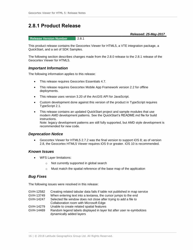
2.8.1 Product Release
Released: 25-May-2017
Release Version Number 2.8.1 This product release contains the Geocortex Viewer for HTML5, a VTE integration package, a QuickStart, and a set of SDK Samples. The following section describes changes made from the 2.8.0 release to the 2.8.1 release of the Geocortex Viewer for HTML5.
Important Information
The following information applies to this release:
• This release requires Geocortex Essentials 4.7.
• This release requires Geocortex Mobile App Framework version 2.2 for offline deployments.
• This release uses version 3.20 of the ArcGIS API for JavaScript.
• Custom development done against this version of the product in TypeScript requires TypeScript 2.1.
• This release contains an updated QuickStart project and sample modules that use modern AMD development patterns. See the QuickStart’s README.md file for build instructions. Note: legacy development patterns are still fully supported, but AMD style development is recommended for new code.
Deprecation Notice
• Geocortex Viewer for HTML5 2.7.2 was the final version to support iOS 8; as of version 2.8, the Geocortex HTML5 Viewer requires iOS 9 or greater. iOS 10 is recommended.
Known Issues
• WFS Layer limitations:
o Not currently supported in global search
o Must match the spatial reference of the base map of the application
Bug Fixes
The following issues were resolved in this release:
GVH-12582 Creating related tabular data fails if table not published in map service
GVH-13749 When entering text into a textarea, the cursor jumps to the end
GVH-14247 Selected file window does not close after trying to add a file to Collaboration room with Microsoft Edge
GVH-14279 Unable to create related spatial features
GVH-14469 Random legend labels displayed in layer list after user re-symbolizes dynamically added layers

Geocortex Viewer for HTML 5: Release Notes
17 | © 2018 Latitude Geographics Group Ltd. All Rights Reserved.
GVH-14471 WMS layers are displayed initially when added through the AssemblyProvider Layer Catalog
GVH-14519 Geolocation time-out error on iOS 10.3 and 10.3.1
GVH-14900 Cannot click command hyperlinks in feature set view in IE 11 and Firefox
GVH-14984 Filter Builder clauses stack when user presses “Filter” button multiple times without any intervening events
GVH-14998 Data frame resize button (handle) is missing on startup
GVH-15014 Setting results list to use Feature Description has no effect – Feature Long Description is always used
GVH-15019 Zoom upon geolocation no longer works
GVH-15041 Images in the results list have unexpected formatting applied
GVH-15081 Images not displayed in Display Form
GVH-15090 Opening and closing the Panel Actions Menu prevents use of Map Tips

Geocortex Viewer for HTML 5: Release Notes
18 | © 2018 Latitude Geographics Group Ltd. All Rights Reserved.
2.8 Product Release
Released: 26-Apr-2017
Release Version Number 2.8.0 This product release contains the Geocortex Viewer for HTML5, a VTE integration package, a QuickStart, and a set of SDK Samples. The following section describes changes made from the 2.7.2 release to the 2.8.0 release of the Geocortex Viewer for HTML5.
Important Information
The following information applies to this release:
• This release requires Geocortex Essentials 4.7.
• This release requires Geocortex Mobile App Framework version 2.2 for offline deployments.
• This release uses version 3.20 of the ArcGIS API for JavaScript.
• Custom development done against this version of the product in TypeScript requires TypeScript 2.1.
Deprecation Notice
• Geocortex Viewer for HTML5 2.7.2 was the final version to support iOS 8; as of version 2.8, the Geocortex HTML5 Viewer requires iOS 9 or greater. iOS 10 is recommended.
New Features
The following features were introduced in this release:
• Tested to be compatible with ArcGIS 10.5:
o ArcGIS for Server
o Portal for ArcGIS
• Solve communication challenges spatially with real-time, map-based collaboration tools
• Clickable graphics, improved editing, editing markup
• The results list now supports grouping of results by layer
• Improved feature highlighting and push-pin interactions between the results list and map
• Easily add or remove from existing results using identify tools
• Enhanced markup symbology controls allow you full control over styles including support for icons
• Filter the layer list and legend to find layers of interest
• Build, save and run more sophisticated queries. This includes:
o ‘OR’ operations with nesting
o Administrator defined queries

Geocortex Viewer for HTML 5: Release Notes
19 | © 2018 Latitude Geographics Group Ltd. All Rights Reserved.
• Dynamically reorder map services and layers within the viewer
• Export to CSV and Excel operations now include related data link data
• Receive instant, ripple-effect feedback when clicking on the map
• Enhanced feedback/notification system to prompt actions
• End users are now able to delete attachments
Known Issues
• WFS Layer limitations:
o Not currently supported in global search
o Must match the spatial reference of the base map of the application
o Cannot be added via layer catalog or user layer addition
• The Quickstart and SDK samples still use the legacy module syntax
Bug Fixes
The following issues were resolved in this release:
GVH-5169 Display Capture Geometry default type not shown as active
GVH-5679 Null reference when using geocortex.request on a secured site and content is not specified
GVH-5860 Results Table Tab arrows off center in Firefox, IE 8, 9, 10
GVH-6746 Toolbar arrow button should not be displayed if number of tools in toolbar is less than number of tools to display
GVH-7788 Long related feature title tabs overlapped in expanded view
GVH-8013 Markdown form item contents do not appear in Handheld shell
GVH-8134 Map clicks sometimes do not register or have a long delay in Chrome
GVH-8427 Font used in Print Map difficult to read in Chrome/IE
GVH-8796 Query value field width shrinks to an unusable width when a large field name exists
GVH-9339 Cannot resize table results view as expected by dragging on edge of table
GVH-9828 ‘Create new Feature’ view remains with ‘no editable field’ error after deleting feature
GVH-9883 Text in Data Region is double-spaced in IE
GVH-10416 Feature hyperlinks convert hyperlink text replacement tokens into an “&” command
GVH-10455 Long URL in feature description causes squished feature details view
GVH-10482 Offline basemap options do not align properly in manager
GVH-10670 Layer List folder still appears in Layer List view when permissions restrict access to layers
GVH-10693 Bottom of text in map tip title is cut off
GVH-10813 Layer’s legend appears in theme that does not have the layer available
GVH-10968 Border is overlapped with legend in legend page
GVH-11057 Mailto links don’t work in map tips
GVH-11287 Workflow returns to HomePanel after being run from HomePanel, without displaying results
GVH-11357 "Show Labels" in customize labels dialog doesn't align with checkbox
GVH-11363 Styling issue with portrait mode on iOS devices
GVH-11510 Styling issue with “Layer Added” confirmation message in Handheld shell

Geocortex Viewer for HTML 5: Release Notes
20 | © 2018 Latitude Geographics Group Ltd. All Rights Reserved.
GVH-11590 Poor performance with table view and thousands of results
GVH-11790 Tab focus length overflows on time slider handles and data picker in FireFox
GVH-11832 Token not being refreshed for layer-secured map services
GVH-11840 Unable to use certain characters on Search Tables via the global search
GVH-11867 High memory usage after doing a few large identify operations
GVH-12004 Incorrect tab title when multiple anonymous feature sets are selected from workflow
GVH-12020 Heat map enabled on uploaded data features becomes opaque in loaded project
GVH-12024 Layer Addition: Feature layers from ArcGIS Online cannot be saved and restored correctly via save project
GVH-12107 Multiple export calls made by viewer on startup
GVH-12157 Can’t identify layers added via layer catalog that have minimum scale set to zero
GVH-12195 NVDA screen reader does not read row description in the debug menu
GVH-12227 Cannot customize labels when service is token secured
GVH-12245 Global Search only works if unchecking “Give Precedence to Nearby Results”
GVH-12290 ViewManager.createView does not properly check for null
GVH-12302 Layer Catalog Assembly Provider: Possibly unhandled TypeError: Cannot read property 'mapServices' of null
GVH-12325 The buildEventBinding function does not check for null
GVH-12334 Color picker not available in Internet Explorer when customizing visualization
GVH-12354 User list appears in IE11
GVH-12356 Named anchor tags (fragments) are removed and root URL is loaded
GVH-12393 Search results can take a long time to display
GVH-12406 Transparency slider not restored properly when a project is opened
GVH-12497 Setting Display Time Zone causes site with time slider to fail to load
GVH-12551 Add layer URL overflow in IE11 and Edge
GVH-12620 Cannot type dates manually into the date picker
GVH-12751 Line layer legend swatch is at the bottom beside the layer text
GVH-12835 "Font Style" checkboxes in label customization are not aligned with their text
GVH-12896 Cannot pick seconds in DatePicker form items
GVH-12951 Default Geographic Coordinate System functionality broken
GVH-12973 Scale Override not respected when set in Layer Catalog
GVH-12975 Menus missing default icon
GVH-13099 Workflow loops, then fails, when changing container name in a sequence
GVH-13127 Closing time slider also closes the data region
GVH-13129 Number of results counted is inconsistent in Table view
GVH-13153 GeoRSS layers with default namespaces are not displayed by the viewer
GVH-13282 Layer List and Legend do not wrap long layer names
GVH-13333 Map tip appears while Edit tool is being activated
GVH-13513 Broken splash logo when local path used
GVH-13592 Splash screen moves around while viewer loads
GVH-13639 Setting Line Width has no effect in Layer Visualization
GVH-13732 Identify operation incorrectly warns that “Feature Set Collection does not exist”
GVH-13829 Cannot re-add features to results list that you previously removed

Geocortex Viewer for HTML 5: Release Notes
21 | © 2018 Latitude Geographics Group Ltd. All Rights Reserved.
2.7.2 Product Release
Released: 5-Dec-2016
Release Version Number 2.7.2 This product release contains the Geocortex Viewer for HTML5, a VTE integration package, a QuickStart, and a set of SDK Samples. The following section describes changes made from the 2.7.1 release to the 2.7.2 release of the Geocortex Viewer for HTML5.
Important Information
The following information applies to this release:
• This release requires Geocortex Essentials 4.6.
• This release requires Geocortex Mobile App Framework version 2.1 for offline deployments.
• Custom development done against this version of the product in TypeScript requires TypeScript 1.8.
• As of iOS version 10.0, Safari’s geolocation capabilities are only supported for applications on secure origins (HTTPS). See https://support.geocortex.com/essentialsGSCForum?id=90660000000PDgrAAG for more information.
Deprecation Notice
• Geocortex Viewer for HTML5 2.7.2 is the final version to support iOS 8; as of version 2.8, the Geocortex HTML5 Viewer will require iOS 9 or greater. iOS 10 is recommended.
Known Issues
• GVH-12406: When a saved project is opened, its layer list transparency slider settings may not be reset properly. For example, a transparency slider set to the minimum position when a project is saved may be set to the maximum position when the saved project is opened.
Bug Fixes
The following issues were resolved in this release:
GVH-4200 Remove calls to deprecated FileError API
GVH-12262 Session expiry warning appears for ArcGIS Online/Portal (requires Essentials 4.6.3)
GVH-12472 Last tool in the list can't display on the compact toolbar
GVH-12480 Maximum call stack size exceeded when using the time slider
GVH-12596 Geocortex Bookmarks stops working after clearing cache in Chrome 54
GVH-12696 Load/Save Projects not working after clearing cache in Chrome 54

Geocortex Viewer for HTML 5: Release Notes
22 | © 2018 Latitude Geographics Group Ltd. All Rights Reserved.
2.7.1 Product Release
Released: 19-Oct-2016
Release Version Number 2.7.1 This product release contains the Geocortex Viewer for HTML5, a VTE integration package, a QuickStart, and a set of SDK Samples. The following section describes changes made from the 2.7 release to 2.7.1 release of the Geocortex Viewer for HTML5.
Important Information
The following information applies to this release:
• This release requires Geocortex Essentials 4.6.
• This release requires Geocortex Mobile App Framework version 2.1 for offline deployments.
• Custom development done against this version of the product in TypeScript requires TypeScript 1.8.
• As of iOS version 10.0, Safari’s geolocation capabilities are only supported for applications on secure origins (HTTPS). See https://support.geocortex.com/essentialsGSCForum?id=90660000000PDgrAAG for more information.
Deprecation Notice
• Geocortex Viewer for HTML5 2.7.1 is the final version to support iOS 8; as of version 2.8, the Geocortex HTML5 Viewer will require iOS 9 or greater. iOS 10 is recommended.
Known Issues
• GVH-12262: When a user is signed into ArcGIS Online, the session expiration warning may not appear until 15 to 20 minutes after the token has already expired.
• GVH-12406: When a saved project is opened, its layer list transparency slider settings may not be reset properly. For example, a transparency slider set to the minimum position when a project is saved may be set to the maximum position when the saved project is opened.
Bug Fixes
The following bug fixes were made:
GVH-3026 Implement Layer Addition using Service Discovery Interface
GVH-6004 Legend items are displayed with incorrect sizes
GVH-8109 In the “Create New Feature” template picker, the line features icon is identical to the polygon icon
GVH-9908 Responses from image services are parsed incorrectly, resulting in no feature details
GVH-10255 Text entered into the “Notes” field in the “Print Map” view appears from right to left

Geocortex Viewer for HTML 5: Release Notes
23 | © 2018 Latitude Geographics Group Ltd. All Rights Reserved.
GVH-10559 Save and Restore project state for Layer Addition feature
GVH-10646 Identify operation generates type errors (“Cannot read property ‘query’ of undefined”)
GVH-10807 Layer excluded from layer list is visible after loading project
GVH-10836 Cancel button in upload data is cut off in Android phone
GVH-10855 Layer lists without any theme configuration may display an empty folder
GVH-11009 Time-aware sliders cannot be saved in a project
GVH-11139 Layer Catalog – Implement “remove” functionality for Assembly Provider
GVH-11155 Layer catalog and user added layers do not respect symbol transparency
GVH-11164 Edit Geometry not functioning for feature layers added via Layer Addition
GVH-11176 Cannot remove a catalog layer from the map until all layers in the folder are removed
GVH-11243 Bookmarks widget popup covered when using the footer module
GVH-11291 Some borders missing in legend list on iOS handheld
GVH-11388 When identifying a raster and in the tabular view, some headers are not associated with the correct field
GVH-11429 Save Open Project for Assembly Provider
GVH-11441 User added layer not displayed correctly in layer list in SDK samples
GVH-11447 Cannot Change Time Slider Start/End Point if Clicking Directly on a Line
GVH-11449 Layer Catalog creating UserAddedLayers Folder
GVH-11453 Label for button that hides the Time Slider is misleading
GVH-11455 Cannot change extent by clicking left side of Time Slider in “cumulative from start” mode
GVH-11457 Restoring tiled or image service does not work with layer catalog Save Open Project
GVH-11463 Removing a layer from a folder while adding one from its sub-folder creates two linked transparency sliders
GVH-11479 Time Slider scale is visible behind blue bar after expanding tabbed toolbar in Chrome
GVH-11497 Unable to use Time Slider in an offline environment
GVH-11516 Cannot load attachments for feature services layers added from layer catalog
GVH-11532 Related data missing in Feature Details for layers added from layer catalog
GVH-11534 Basemap folder icons in layer list appear at wrong location
GVH-11537 Viewer does not pan or zoom to a related record when clicked
GVH-11545 Layer Catalog – implement some changes needed for "RemoveUserAddedLayer"
GVH-11546 Layer Catalog – empty user added layers folder is recovered while opening saved project
GVH-11556 Layer Catalog – change esri.layers.ArcGISDynamicMapServiceLayer._img exists to hit a different dynamic map service
GVH-11618 Cannot identify Upload Data
GVH-11621 QuickStart configuration is out of date
GVH-11624 Show site's rest endpoint in viewer log
GVH-11639 Layer Catalog – Assembly Provider has multiple ways to check/uncheck from layer list
GVH-11641 Callout map tips show content (rather than title) in title field
GVH-11643 All layers turn visible when adding/removing a layer with Layer Catalog
GVH-11645 Moving end-time handle causes start-time handle to move (Handheld)
GVH-11651 Time slider handle misbehaves when "Time Instant" mode is set
GVH-11653 Layer Catalog – layer disappears from map while adding another layer from layer catalog

Geocortex Viewer for HTML 5: Release Notes
24 | © 2018 Latitude Geographics Group Ltd. All Rights Reserved.
GVH-11660 “Place User Added Layer Here” folder remains invisible until layer added from Layer Catalog
GVH-11664 Cannot Edit Multi Point Feature
GVH-11669 Type errors ("Cannot read property 'isCodedValueDomain' of undefined") are generated when adding layers via layer catalog
GVH-11671 Time Slider – cannot access parts of UI in landscape mode on Handheld Android devices
GVH-11675 Time Slider – styling issues with labels
GVH-11695 Add help link for Measurement page in Management Pack
GVH-11696 Layers from Layer Catalog that are not contained in folders do not get removed from layer list
GVH-11700 Remove "smartOrderUserAddedLayers" and "insertPosition" from LayerAdditionViewModel configuration
GVH-11701 Add a UserLayerType property to services and layers added at runtime
GVH-11708 Layer Catalog – Remove configuration check for smart ordering
GVH-11711 Layer Catalog – Layer list check/uncheck is reset when adding layers from layer catalog seed site provider
GVH-11724 Date picker keyboard support
GVH-11727 SDK sample does not navigate correctly after external webpage opened in iframe
GVH-11729 Update time slider setting tab icon
GVH-11732 Layer Catalog type error in initializing layer: “Unable to draw graphic (geometry:null, symbol:null): Cannot read property 'parent' of undefined”
GVH-11740 Create a language string for Layer Addition Unsupported WKID error
GVH-11743 Layer Addition – color of success message
GVH-11753 SDK Samples: Add Layer example broken
GVH-11755 Time slider still displayed on the map when loading a saved project without time slider profile
GVH-11759 Time slider handles are not screen reader-friendly
GVH-11769 Cannot delete DateTime in an Edit Feature Session
GVH-11777 "Write to Drawing Layer" is not aligned to checkbox
GVH-11779 Base map layer legend is not aligned properly in FireFox
GVH-11792 Time slider handles do not work when screen readers enabled
GVH-11814 Layer Catalog Assembly Provider – spaces in URL of essentials layer
GVH-11828 Save Results – “Currently Open” text on the same line as results name
GVH-11830 Secured geocoding service does not pass token in URL for Reverse Geocodes
GVH-11835 Null check needed when getting default renderers in case a cluster layer data source has gone missing.
GVH-11842 Dynamic Symbolization – search extent does not increase if initial query returns no results
GVH-11849 Modify MapTextProvider to include map time extent description
GVH-11856 Smart ordering causes assembly provider layer catalog pre-added layers to be ignored
GVH-11863 Fields used to make subtypes claim to have coded domains even when they do not, causing symbolization to fail
GVH-11865 Failed service icon appears under layer name in layer list (Firefox)
GVH-11869 Long layer name overlaps with transparency slider in handheld
GVH-11875 Layer Addition – error When Adding WMS Services in IE
GVH-11889 Layer Catalog – whole layer catalog tree structure is removed while removing a layer in presence of other layer catalog layers
GVH-11899 Highlights on map do not update if layer renderer changes
GVH-11927 Layer Catalog – error when removing vector tile service

Geocortex Viewer for HTML 5: Release Notes
25 | © 2018 Latitude Geographics Group Ltd. All Rights Reserved.
GVH-11931 Load saved project does not function correctly
GVH-11941 Unique Value renderer fails mysteriously in Chrome
GVH-11945 Time extent does not disappear when set to “time instant” mode
GVH-11948 Layer Catalog – permissions not being properly applied
GVH-11953 Include LabelLayer.js in Esri scripts
GVH-11958 Identify does not work for WMS services added from Layer Catalog
GVH-11964 Layer Visualization will not reset to default using Layer Catalog with dynamic layers
GVH-11972 Legend is not retrieved if a Dynamic map service URL does not end with "/Mapserver"
GVH-11974 Workflow date picker remembers the last selected date even after clearing the date field
GVH-11978 Identify does not work for WMS services that do not support the "Query" operation
GVH-11986 Layer catalog does not support secured map service with token security
GVH-12017 Uploaded data does not appear in results list/table when loading the saved project
GVH-12024 Layer Addition – feature layers from ArcGIS Online cannot be saved and restored correctly via save project
GVH-12028 Upgrading to GVH 2.7 resets the Analytics Client Relay to the default
GVH-12034 Changing Opacity in "Set Map Service Property" activity does not have any effect on map service
GVH-12054 Folder icon changes its position after upgrade GVH 2.6.1 to 2.7
GVH-12062 Unable to run report on layers added via Layer Catalog
GVH-12086 Related features/tables not working with Layer Catalog
GVH-12088 Data links do not work with Layer Catalog
GVH-12124 Cannot resymbolize labels if original label has no halo
GVH-12146 Changing text of Input Scale 'GO' button results in its wrapping below
GVH-12175 Global search results from Bing Geocoder do not have a display name
GVH-12206 Query does not highlight feature services that are re-projected
GVH-12233 Bookmarks list can be covered by the footer module
GVH-12243 Can’t identify a WMS backed by a WFS containing raster features

Geocortex Viewer for HTML 5: Release Notes
26 | © 2018 Latitude Geographics Group Ltd. All Rights Reserved.
2.7 Product Release
Released: 8-Aug-2016
Release Version Number 2.7 This product release contains the Geocortex Viewer for HTML5, a VTE integration package, a QuickStart, and a set of SDK Samples. The following section describes changes made from the 2.6.1 release to 2.7 release of the Geocortex Viewer for HTML5.
Important Information
The following information applies to this release:
• This release requires Geocortex Essentials 4.6.
• Custom development done against this version of the product in TypeScript requires TypeScript 1.8.
New Features
The following features were introduced in this release:
• Tested to be compatible with ArcGIS 10.4.1:
o ArcGIS for Server
o Portal for ArcGIS
• API Updates
o The API uses version 3.17 of the ArcGIS API for JavaScript.
o The API is built using TypeScript 1.8.
• Users can use a new Time Slider control to manipulate the time extent of the map.
• Users can change the rendering of layers on the fly with new Dynamic Symbolization controls.
• Users can toggle and reconfigure the labels of layers on the fly.
• Users can add layers to the map from a predefined list of catalog layers set by the administrator.
• Users can search for services and layers by URL or keyword and add them to the map.
• When performing a buffered identify operation the end user now has the option of persisting the buffer polygons to the drawings layer.
• Management Improvements. Administrators are now able to:
o Edit all menus
o Configure the “Hide on Disabled” behavior of menu items
o Configure color of the I Want To menu and other components
o Publish viewer URLs to ArcGIS Online and Portal for ArcGIS.

Geocortex Viewer for HTML 5: Release Notes
27 | © 2018 Latitude Geographics Group Ltd. All Rights Reserved.
Known Issues
• Services and Layers added to the map by end users through Layer Addition are not stored in saved projects
Bug Fixes
The following bug fixes were made:
GVH-5525 Allow viewer command links in the home panel to be made WCAG-compliant
GVH-6955 Map tips won't show resolved coded value domain when one feature is selected
GVH-7552 Change title of view from “Create a feature” to “Create New Feature”
GVH-7947 Some requests to WMS service are not being sent through configured proxy page
GVH-8747 Accessibility icon background does not respect banner background color
GVH-8844 If the I Want To Menu contains no items, it displays poorly
GVH-8900 Some graphical elements do not have adequate contrast
GVH-9178 The Printing module fails to print correct layers if the map scale differs from the print scale
GVH-9351 For Android tablets, items in the Saved Selection results view are missing their bottom borders
GVH-9386 For the Tablet shell, items in the I Want To Menu are missing their separating borders
GVH-9462 In the Offline Maps manager, a long name string will overlap the edit box
GVH-9653 Share Project styling
GVH-9710 The Upload Data module is retaining Custom WKID field information for subsequent upload calls
GVH-9752 The measurement unit dropdown tool is not centered in the tabbed toolbar
GVH-9918 Legend label wraps in the Layer List
GVH-10025 Feature results remain in results list after feature’s uploaded layer is removed
GVH-10059 Upload Data dialog styling
GVH-10091 Make infrastructure.taskUtils.getQueryTaskUrl method backwards-compatible for GVH 2.5
GVH-10112 The Offline Maps UI is inconsistent with the rest of the viewer
GVH-10223 Unable to open Scale Input Box using keyboard controls in IE11 and Firefox
GVH-10272 IE 10 and 11 don't trust URLs that are on the whitelist
GVH-10318 The GetLayerInfoByProperty does not work for table layers
GVH-10350 If user edits/deletes a feature more than once, the Saved Result view does not update properly
GVH-10354 If a URL is added to the viewerConfig object in the Index.html file, the splash screen will not appear
GVH-10380 Upgrading to GVH 2.6 breaks Insight client relay
GVH-10390 Letters are chopped from search text when using Instant Search if the search string contains both letters and numbers
GVH-10401 The Map's WKID is appended to "Map's Current" option in spatial reference dropdown every time Table Mapping Details dialogue is displayed
GVH-10408 When the chart view closes, highlights remain visible
GVH-10457 Hyperlinks built with replacement tokens do not work if content contains curly braces
GVH-10473 Cannot hide labels on the y-axis of a scatterplot chart

Geocortex Viewer for HTML 5: Release Notes
28 | © 2018 Latitude Geographics Group Ltd. All Rights Reserved.
GVH-10487 The input “{{context}}” reported as Invalid JSON by management pack
GVH--10494 Map tip menu items should be left-justified rather than right-justified
GVH-10500 In the Saved Results view, a long name overlaps with the view’s edit and delete buttons
GVH-10505 If the combine mode is set to subtract or intersect in the selectFeatures workflow, the collection name is not populated
GVH-10529 The "Zoom Upon Geolocation" checkbox does not remain unchecked
GVH-10538 The offline page title displays incorrectly in management pack
GVH-10562 Clicking a related record from Table Layer navigates to an incorrect layer
GVH-10569 The Workflow combobox does not set the selected value
GVH-10574 Incorrect word order in warning message when tool cannot execute a command
GVH-10576 Global searches for a text string containing a number return incomplete results
GVH-10614 Query builder in iOS displays blank fields when loaded in Airplane Mode
GVH-10624 Map context menu does not appear when no coordinate system is configured and "Show coordinates" is enabled
GVH-10644 In SDK Samples, the custom search provider returns a language key rather than the related value
GVH-10660 Layer List doesn't honor order of layers added through the layer catalog
GVH-10675 8-Digit Numbers entered into the Filter tool are converted into dates
GVH-10688 In IE 11 clicking exactly in the check box does not change its state
GVH-10690 User is able to open Create Feature tool even when using basic license offline
GVH-10701 Mixed content error when uploading FGDB to ArcGIS Online
GVH-10711 Cannot upload data to AGOL when signed in to Enterprise account as User
GVH-10745 Upload FGDB/ShapeZip data not exporting in opened project
GVH-10762 Empty Layer Theme causes exceptions
GVH-10766 ExportResultsTo documentation appears within the 'null' section of the API Reference
GVH-10781 Additional info required for Unknown Error when upload data tool is used
GVH-10807 Layer excluded from layer list is visible after loading project
GVH-10832 Query Builder race condition when restoring projects
GVH-10883 Save project excludes attributes due to missing ContentPolicy instance
GVH-10903 Unable to manage or create attachments for AGOL hosted feature layer
GVH-10924 User Added Layer List Folder items' state should be maintained across theme changes
GVH-10960 "Download report" link not highlighted when report is run from the results list context menu
GVH-10981 Basemap Slider causes layer to disappear

Geocortex Viewer for HTML 5: Release Notes
29 | © 2018 Latitude Geographics Group Ltd. All Rights Reserved.
2.6.1 Product Release
Released: 6-May-2016
Release Version Number 2.6.1 This product release contains the Geocortex Viewer for HTML5, a VTE integration package, a QuickStart, and a set of SDK Samples. Custom development done against this version of the product in TypeScript requires TypeScript 1.5. The following section describes changes made from the 2.6 release to 2.6.1 release of the Geocortex Viewer for HTML5.
Important Information
• This release requires Geocortex Mobile App Framework version 2.0.1 for offline deployments.
• As of Google Chrome version 50 geolocation capabilities are only supported for applications on secure origins (HTTPS). See https://support.geocortex.com/EssentialsGSCForum?id=906600000000BdyAAE for more information.
Known Issues
• GVH-8134 Map clicks sometimes do not register in Chrome
Bug Fixes
The following issues were resolved in this release:
GVH-4335 Improve automatic positioning of the legend in multi-feature Charts
GVH-4500 No way to return to full list of create-able features
GVH-5525 Viewer command links in home panel cannot be made WCAG compliant
GVH-6955 Map tips won't show resolved coded value domain when one feature is selected
GVH-7106 Unable to show feature detail by clicking points on Chart in handheld
GVH-8368 Leaving the name field blank when renaming a collection of Saved Results does not fail properly
GVH-8490 Uploaded KML File only displays one visible marker
GVH-8545 Honor Time Zone Offsets in Reports
GVH-8614 Menu system doesn't respect defaultIconUri
GVH-8741 Overwriting the saved refine results causes some features to disappear from saved results
GVH-8747 Accessibility icon background does not respect banner background color
GVH-8751 Results view title is not indicating saved results after overwriting the saved results with same name.
GVH-9048 Proxy configured in workflow ComboBox form item is not respected by viewer
GVH-9067 Feature 'Applying edits...' view is stuck and saved results total doesn't match when manually add/remove new feature in viewer

Geocortex Viewer for HTML 5: Release Notes
30 | © 2018 Latitude Geographics Group Ltd. All Rights Reserved.
GVH-9154 Charts and 3rd party maps selector only allows one item selected at a time
GVH-9195 Don't show offline maps as orphaned that are known to be inaccessible by security
GVH-9462 Long name string overlaps edit box in Offline Maps manager
GVH-9464 Offline Maps edit basemap UI panels overlap container
GVH-9599 TypeError thrown when a small set of results is combined with a larger set
GVH-9699 Viewer crashes when changing orientation during QR code scanning on iOS
GVH-9728 Very long saved result title not displayed correctly
GVH-9744 Visualization options remains in data region after completion
GVH-9783 Configured feature fill and border colors are not respected in saved projects
GVH-9822 Project List entry styling issues
GVH-9866 Attachments option appears in menu for layers that do not support attachments
GVH-9923 Switching to between Layer Theme with Basemap only present in first theme causes basemap to be deselected
GVH-9994 Data Link tab not showing when Relationship row clicked to navigate
GVH-10005 Uploaded layers visualization options do not function properly after loading project
GVH-10012 Visualization "Done" button should go back to the previous page instead of layer list
GVH-10074 Toolbar command parameter displays as [object Object]
GVH-10076 Alternate Context Menu address handling required for reverse geocoders that do not return "Match_addr" property
GVH-10078 "Attach a file or photo" option doesn’t appear in action menu following a single click on a feature
GVH-10082 Mouse Coordinates toggle button should use language key rather than hardcoded English string
GVH-10094 Improve contrast of Upload Data colors
GVH-10112 Offline maps UI style inconsistencies
GVH-10114 Layers in a map service within two different layer list folders can affect each other’s visibility
GVH-10118 Unable to create new features with QR Scan in Windows App
GVH-10119 GVH Bridge throws errors when enabling ChromeVox
GVH-10132 User-uploaded layers should be excluded from the query builder
GVH-10156 Uploaded Heatmap layer fails to load when opening a project from a URL
GVH-10158 Cannot save Plot Coordinate state if coordinate editing is active
GVH-10177 Linked Maps action buttons styling
GVH-10195 Support field formats that include the field’s time zone offset from UTC
GVH-10199 Select Existing Feature option (QR Code scanner) doesn't return the list of selected features
GVH-10240 Base map and visualization legend are not respected by layer list visibility
GVH-10245 Offline Map becomes corrupt if sync fails when 'downloading site resources'
GVH-10253 View with view model MultiFeatureSelectorViewModel has no method 'setFeatureView'
GVH-10268 Map Context Menu - Long strings in "Address" field do not wrap
GVH-10272 IE 10 and 11 don’t trust certain whitelisted URLs
GVH-10288 Access denied error message is not correctly displayed when a user attempts to sign in to a viewer they do not have permission to view
GVH-10291 Share project spacing issues
Geocortex Viewer for HTML 5: Release Notes
31 | © 2018 Latitude Geographics Group Ltd. All Rights Reserved.
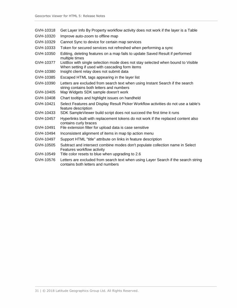
GVH-10318 Get Layer Info By Property workflow activity does not work if the layer is a Table
GVH-10320 Improve auto-zoom to offline map
GVH-10329 Cannot Sync to device for certain map services
GVH-10333 Token for secured services not refreshed when performing a sync
GVH-10350 Editing, deleting features on a map fails to update Saved Result if performed multiple times
GVH-10377 ListBox with single selection mode does not stay selected when bound to Visible When setting if used with cascading form items
GVH-10380 Insight client relay does not submit data
GVH-10385 Escaped HTML tags appearing in the layer list
GVH-10390 Letters are excluded from search text when using Instant Search if the search string contains both letters and numbers
GVH-10405 Map Widgets SDK sample doesn't work
GVH-10408 Chart tooltips and highlight issues on handheld
GVH-10421 Select Features and Display Result Picker Workflow activities do not use a table's feature description
GVH-10433 SDK SampleViewer build script does not succeed the first time it runs
GVH-10457 Hyperlinks built with replacement tokens do not work if the replaced content also contains curly braces
GVH-10491 File extension filter for upload data is case sensitive
GVH-10494 Inconsistent alignment of items in map tip action menu
GVH-10497 Support HTML "title" attribute on links in feature description
GVH-10505 Subtract and intersect combine modes don't populate collection name in Select Features workflow activity
GVH-10549 Title color resets to blue when upgrading to 2.6
GVH-10576 Letters are excluded from search text when using Layer Search if the search string contains both letters and numbers

Geocortex Viewer for HTML 5: Release Notes
32 | © 2018 Latitude Geographics Group Ltd. All Rights Reserved.
2.6 Product Release
Released: 31-Mar-2016
Release Version Number 2.6 This product release contains the Geocortex Viewer for HTML5, a VTE integration package, a QuickStart, and a set of SDK Samples. Custom development done against this version of the product in TypeScript requires TypeScript 1.5. The following section describes changes made from the 2.5.3 release to 2.6 release of the Geocortex Viewer for HTML5.
New Features
The following features were introduced in this release:
• API Updates o Version 3.16 of Esri’s JavaScript API integrated
• Allow end users to save, share and load project files
• Allow end users to save, open and modify collections of features
• Allow end users to upload feature data
• Improvements and new additions to the SDK samples
• Provide a map scale input box
• Provide a map context menu at a location by right-click or long-press
• Initial support for Vector Tile Layers
• Improvements to charting
• Support for field value manipulation on date/time, numeric fields, and time zones
• Support for search tables in Global Search
• Enhancements to the Layer Search and Instant Search providers with support for standalone and related tables
• Reverse geocoding functionality in the Map Context Menu
• Customizable splash screen
• Improvements to markup measurement presentation
• Allow end users to save markup/drawings to Shapefile
• Provide a new print preview dialog
• New Global Menu in the I Want to Menu
Deprecation Notice
• Geocortex Viewer for HTML5 2.5 was the final version to support Internet Explorer 8; as of version 2.6, the Geocortex HTML5 Viewer requires Internet Explorer 9 or later. The latest version of Microsoft Edge, Google Chrome or Mozilla Firefox is recommended.

Geocortex Viewer for HTML 5: Release Notes
33 | © 2018 Latitude Geographics Group Ltd. All Rights Reserved.
Known Issues
• GVH-8134 Map clicks sometimes do not register in Chrome
Bug Fixes
The following bug fixes were made:
GVH-9844 Layer definition not respected when exporting or printing for polygon
GVH-9842 Memory usage incrementally increases on reload in IE and Edge
GVH-9681 Error message not properly rendered in "Display Resutls Picker" when no features are selected
GVH-9249 High memory usage for large site in IE 11 and Edge
GVH-9187 Barcode scanner broken on GMAF Android with Chrome 47 installed
GVH-8910 If the data frame contains an active view, users should not be able to focus on the placeholder view
GVH-8908 Add title attribute to the delete button in the Query or Filter Builder UI
GVH-8906 Make sure all HTML elements have unique ids, if they are needed at all
GVH-8904 Ensure text in the accessibility information modal dialog is a language string that can be translated
GVH-8902 Advertise language of the page
GVH-8900 Some elements don't have adequate contrast
GVH-8898 Update menu systems so that bold text are now headings
GVH-8896 Add alt tags to layer list icons
GVH-8813 Show map tip setting in management pack not respected by pushpin
GVH-8644 Field types for catalog items are not respected
GVH-8556 Report command aliases unimplemented
GVH-8554 Report commands not hyperlinkable
GVH-8548 GVH 2.5 QuickStart guide contains old Defaults.json.js configuration file
GVH-8533 Query or Filter builder support for user added layers
GVH-8370 LayerName token does not resolve in feature description commands
GVH-8355 Map Tip callout generates a null type error when the selected feature has null geometry
GVH-8288 Measurement segment labels always display when a circle is printed or exported
GVH-8243 Closing a map tip twice removes pushpin from the map
GVH-8225 Snapping measurement line inaccurate
GVH-8149 First letter in text area on a workflow form is not displayed
GVH-8130 Default selected layers for measurement snapping not honoured
GVH-8121 Issue with User Defined Layers
GVH-8065 Callout-style maptips don't respond to inline table width formatting
GVH-7984 Unable to find dynamic catalog layer by GetMapServiceInfo workflow activity
GVH-7982 Some legend swatches don't show on initial load
GVH-7945 Datepicker in workflow form not presented in the right locale on iPads
GVH-7846 Screen reader skips from modal dialog text to map extent text
GVH-7840 All links within user guides need updating to the new Communities site

Geocortex Viewer for HTML 5: Release Notes
34 | © 2018 Latitude Geographics Group Ltd. All Rights Reserved.
GVH-7812 Workflow button hover state contrast not high enough
GVH-7808 Information text for zoom in or zoom out selection functions should not include rotation and vertex info
GVH-7793 Proper labels for print title or text attributes
GVH-7713 Zooming or dragging pointer on chart configured to zoom does nothing
GVH-7518 Raster identify with multiple raster layers returns no results if any layer has NoData value
GVH-7413 Layer visibility affecting callout map tip location
GVH-7379 Query or Filter builder should not exclude layers that are not in the layer list.
GVH-7330 Event ComponentViewpointUpdatedEvent in IntegrationModule is susceptible to null reference exceptions
GVH-7279 Case in shortened URL can cause export issues CSV Excel or Shapefile
GVH-7146 Related Features/Data Links in feature details expanded view do not have pagination controls
GVH-7011 Display Capture Geometry dialogue hidden behind workflow panel
GVH-6984 Combo box backed with date objects shows UNIX timestamp instead of properly formatted date
GVH-6835 Bar chart series are sorted incorrectly
GVH-6536 Set a datalink as the default tab in table view not working
GVH-6485 SSL not being applied to legend URL requests to a WMS service, causing a mixed content warning in the viewer
GVH-6404 No way to display workflow results from specific workflows in the results table
GVH-6215 Tools in toolbar offset horizontally by toolbar tabs in Firefox
GVH-6180 English strings present in translated GVH management pack
GVH-6032 Improve MapTextProvider performance
GVH-6001 Some fields from SQL-backed non-SEP service round decimal point-containing fields
GVH-5982 Feature hyperlinks appearing at bottom of feature details when layer Invalid or Broken set to "Show Disabled"
GVH-5932 Dialog box renders momentarily in a random location before being shown center screen
GVH-5598 Error exporting data with large numbers to SHP, XLSX, or CSV
GVH-5431 Global Search does not return formatted values in dataframe
GVH-4860 Export to CSV/XLSX/SHP should respect configuration made on the fields tab
GVH-4673 Get Map Service Info workflow activity does not return ID when used on a table
GVH-4538 Query or Filter builder support for dynamic layers
GVH-4367 Filter builder does not respect spatial filter field
GVH-4351 Activating charting highlights makes feature highlight color opaque instead of transparent
GVH-4195 Submitting workflow form with textbox in Firefox prompts you to save the password
GVH-3932 Allow Administrator to configure short launch links without editing the Index.html
Geocortex Viewer for HTML 5: Release Notes
35 | © 2018 Latitude Geographics Group Ltd. All Rights Reserved.
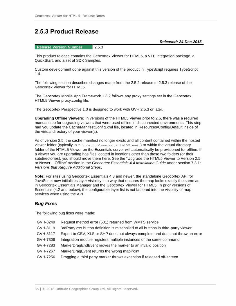
2.5.3 Product Release
Released: 24-Dec-2015
Release Version Number 2.5.3 This product release contains the Geocortex Viewer for HTML5, a VTE integration package, a QuickStart, and a set of SDK Samples. Custom development done against this version of the product in TypeScript requires TypeScript 1.4. The following section describes changes made from the 2.5.2 release to 2.5.3 release of the Geocortex Viewer for HTML5. The Geocortex Mobile App Framework 1.3.2 follows any proxy settings set in the Geocortex HTML5 Viewer proxy.config file. The Geocortex Perspective 1.0 is designed to work with GVH 2.5.3 or later. Upgrading Offline Viewers: In versions of the HTML5 Viewer prior to 2.5, there was a required manual step for upgrading viewers that were used offline in disconnected environments. This step had you update the CacheManifestConfig.xml file, located in Resources/Config/Default inside of the virtual directory of your viewer(s). As of version 2.5, the cache manifest no longer exists and all content contained within the hosted viewer folder (typically in C:\inetpub\wwwroot\Html5Viewer) or within the virtual directory
folder of the HTML5 Viewer on the Essentials server will automatically be provisioned for offline. If a viewer you are upgrading has files located in locations other than those two folders (or their subdirectories), you should move them here. See the “Upgrade the HTML5 Viewer to Version 2.5 or Newer – Offline” section in the Geocortex Essentials 4.4 Installation Guide under section 7.3.1: Versions that Require Additional Steps. Note: For sites using Geocortex Essentials 4.3 and newer, the standalone Geocortex API for JavaScript now initializes layer visibility in a way that ensures the map looks exactly the same as in Geocortex Essentials Manager and the Geocortex Viewer for HTML5. In prior versions of Essentials (4.2 and below), the configurable layer list is not factored into the visibility of map services when using the API.
Bug Fixes
The following bug fixes were made:
GVH-8249 Request method error (501) returned from WMTS service
GVH-8119 3rdParty.css button definition is misapplied to all buttons in third-party viewer
GVH-8117 Export to CSV, XLS or SHP does not always complete and does not throw an error
GVH-7306 Integration module registers multiple instances of the same command
GVH-7283 MarkerDragEndEvent moves the marker to an invalid position
GVH-7267 MarkerDragEvent returns the wrong mapPoint
GVH-7256 Dragging a third party marker throws exception if released off-screen

Geocortex Viewer for HTML 5: Release Notes
36 | © 2018 Latitude Geographics Group Ltd. All Rights Reserved.
2.5.2 Product Release
Released: 4-Nov-2015
Release Version Number 2.5.2 This product release contains the Geocortex Viewer for HTML5, a VTE integration package, a QuickStart, and a set of SDK Samples. Custom development done against this version of the product in TypeScript requires TypeScript 1.4. The following section describes changes made from the 2.5.1 release to 2.5.2 release of the Geocortex Viewer for HTML5. The Geocortex Mobile App Framework 1.3.2 follows any proxy settings set in the Geocortex HTML5 Viewer proxy.config file. Upgrading Offline Viewers: In versions of the HTML5 Viewer prior to 2.5, there was a required manual step for upgrading viewers that were used offline in disconnected environments. This step had you update the CacheManifestConfig.xml file, located in Resources/Config/Default inside of the virtual directory of your viewer(s). As of version 2.5, the cache manifest no longer exists and all content contained within the hosted viewer folder (typically in C:\inetpub\wwwroot\Html5Viewer) or within the virtual directory
folder of the HTML5 Viewer on the Essentials server will automatically be provisioned for offline. If a viewer you are upgrading has files located in locations other than those two folders (or their subdirectories), you should move them here. See the “Upgrade the HTML5 Viewer to Version 2.5 or Newer – Offline” section in the Geocortex Essentials 4.4 Installation Guide under section 7.3.1: Versions that Require Additional Steps. Note: For sites using Geocortex Essentials 4.3 and newer, the standalone Geocortex API for JavaScript now initializes layer visibility in a way that ensures the map looks exactly the same as in Geocortex Essentials Manager and the Geocortex Viewer for HTML5. In prior versions of Essentials (4.2 and below), the configurable layer list is not factored into the visibility of map services when using the API.
Bug Fixes
The following bug fixes were made:
GVH-7919 Layer list configuration is changed after catalog layers are added to the map
GVH-7820 Excessive and duplicated snapping queries on viewer startup
GVH-7747 Coded domains sometimes do not resolve when the attribute value is 0
GVH-7720 Feature attributes with a value of 0 show "N/A" instead
GVH-7600 Snapping dynamic layers needs to respect layer definition
GVH-7556 Identify returns incorrect result for numeral coded value domains
GVH-7503 Basemap export requests made when offline if basemap is dynamic
GVH-7336 Layer Selector does not get new layers when they are added to a map service
GVH-7304 BaseUrl property is not used for all necessary resources

Geocortex Viewer for HTML 5: Release Notes
37 | © 2018 Latitude Geographics Group Ltd. All Rights Reserved.
GVH-7226 Report visibility setting is not respected in HTML5 Viewer
GVH-7224 Create a 'ShowFirstFeatureFromCollection' Command
GVH-7221 Failure to initialize site for base maps slider in iOS
GVH-7158 Can't access parts of GVH Management pack if you have removed the offline module in configuration json
GVH-7150 Layer List is cleared after a new catalog layer is added from the client.
GVH-7109 Cascading Combobox value cannot be selected if there is only one value or if none is selected
GVH-7040 Non-visible layers appear in print
GVH-6975 "Add Bookmark" dialogue and text markup duplicates first letter of typed in field
GVH-6690 Workflow to populate layers in a list box does not function
GVH-6020 Feature zoom animation is out-of-sync with base map
GVH-6002 Error displayed when printing a particular WMS service
GVH-5598 Error exporting data with large numbers to shp, xlsx, or csv

Geocortex Viewer for HTML 5: Release Notes
38 | © 2018 Latitude Geographics Group Ltd. All Rights Reserved.
2.5.1 Product Release
Released: 13-Oct-2015
Release Version Number 2.5.1 This product release contains the Geocortex Viewer for HTML5, a VTE integration package, a QuickStart, and a set of SDK Samples. Custom development done against this version of the product in TypeScript requires TypeScript 1.4. The following section describes changes made from the 2.5 release to 2.5.1 release of the Geocortex Viewer for HTML5. Upgrading Offline Viewers: In versions of the HTML5 Viewer prior to 2.5, there was a required manual step for upgrading viewers that were used offline in disconnected environments. This step had you update the CacheManifestConfig.xml file, located in Resources/Config/Default inside of the virtual directory of your viewer(s). As of version 2.5, the cache manifest no longer exists and all content contained within the hosted viewer folder (typically in C:\inetpub\wwwroot\Html5Viewer) or within the virtual directory
folder of the HTML5 Viewer on the Essentials server will automatically be provisioned for offline. If a viewer you are upgrading has files located in locations other than those two folders (or their subdirectories), you should move them here. See the “Upgrade the HTML5 Viewer to Version 2.5 or Newer – Offline” section in the Geocortex Essentials 4.4 Installation Guide under section 7.3.1: Versions that Require Additional Steps. Note: For sites using Geocortex Essentials 4.3 and newer, the standalone Geocortex API for JavaScript now initializes layer visibility in a way that ensures the map looks exactly the same as in Geocortex Essentials Manager and the Geocortex Viewer for HTML5. In prior versions of Essentials (4.2 and below), the configurable layer list is not factored into the visibility of map services when using the API.
Bug Fixes
The Geocortex Viewer for HTML5 version 2.5.1, along with Geocortex Essentials 4.4.2, contains an important security upgrade which resolves an issue where the viewer may expose REST security tokens when using secured sites with external, non-secure services. We suggest that all users of Geocortex Essentials and the Geocortex Viewer for HTML5 who have secured sites with external services upgrade to HTML5 Viewer 2.5.1 and Essentials 4.4.2.
The following bug fixes were made:
GVH-6286 Layer not queryable following upgrade to Essentials 4.4 / Viewer for HTML5 2.5
GVH-6174 Global Search Fails With Essentials Site Security

Geocortex Viewer for HTML 5: Release Notes
39 | © 2018 Latitude Geographics Group Ltd. All Rights Reserved.
2.5 Product Release
Released: 4-Sep-2015
Release Version Number 2.5 This product release contains the Geocortex Viewer for HTML5, a VTE integration package, a QuickStart, and a set of SDK Samples. Custom development done against this version of the product in TypeScript requires TypeScript 1.4. The following section describes changes made from the 2.4.2 release to 2.5 release of the Geocortex Viewer for HTML5. Upgrading Offline Viewers: In versions of the HTML5 Viewer prior to 2.5, there was a required manual step for upgrading viewers that were used offline in disconnected environments. This step had you update the CacheManifestConfig.xml file, located in Resources/Config/Default inside of the virtual directory of your viewer(s). As of version 2.5, the cache manifest no longer exists and all content contained within the hosted viewer folder (typically in C:\inetpub\wwwroot\Html5Viewer) or within the virtual directory
folder of the HTML5 Viewer on the Essentials server will automatically be provisioned for offline. If a viewer you are upgrading has files located in locations other than those two folders (or their subdirectories), you should move them here. See the “Upgrade the HTML5 Viewer to Version 2.5 or Newer – Offline” section in the Geocortex Essentials 4.4 Installation Guide under section 7.3.1: Versions that Require Additional Steps. Note: For sites using Geocortex Essentials 4.3 and newer, the standalone Geocortex API for JavaScript now initializes layer visibility in a way that ensures the map looks exactly the same as in Geocortex Essentials Manager and the Geocortex Viewer for HTML5. In prior versions of Essentials (4.2 and below), the configurable layer list is not factored into the visibility of map services when using the API.
New Features
The following features were introduced in this release:
• API Updates o Version 2.11 of the Essentials API for JavaScript included o Version 3.14 of Esri’s JavaScript API integrated
• Buffer support for tools and features, with configurable buffer distance and units
• Allow end users to select identifiable layers
• Visualization of point-based features with heatmaps, including weight by field
• Visualization of point-based features with interactive clustering o Clusters can be identified and “explode” to reveal contributing points when clicked
• Search, query and identify on WMS layers that have an associated WFS service
• Improved loading and performance (perceived and actual)
• More accessibility improvements, including indicating to screen readers when views show and hide in the interface. A new accessibility icon and description is also included in the banner.
• Improved geolocation accuracy algorithm with configurable thresholds

Geocortex Viewer for HTML 5: Release Notes
40 | © 2018 Latitude Geographics Group Ltd. All Rights Reserved.
• Report selection interface for running reports on features in the results list or result table
• Client-side handling of coded value domains, eliminating the need to use the Services Enhancement Proxy
• Basemap groups allow users to toggle the visibility of multiple basemap services at once by choosing a single conceptual basemap
• Fully pre-configured toolbar with context-sensitive tools and stateful toggle buttons
• New stateful “Toggle Button” toolbar item allows buttons that can be in “on” or “off” state with associated commands that execute when transitioning state
• New context-sensitive toolbars can be configured to show when certain tools are activated. For example, display buffer and select layer options when identify tool is activated
• Allow the user to create a feature on a feature layer from geolocation/GPS
• Full support for identify on raster layers and image services
• Configurable option to hide the legend for invisible or out-of-scale layers in the Layer List
• Panel sizes (such as the Data Region and Results Region) are configurable with percentage values
• Enable snapping behavior on all shape tools, with support for snapping to vertices and edges of existing geometries
• Support for multi-line geocoders in Global Search
• Support for secured geocode and geometry services
• Use geometry and geocode services configured in the site, not the viewer\
• APIs that can be used to undo and redo actions on the map (such as edits and drawings)
• APIs that can be used to perform cuts and unions of editable geometries
• Improvements and new additions to the SDK samples
Deprecation Notice
• Geocortex Viewer for HTML5 2.5 is the final version to support Internet Explorer 8 as a desktop browser; as of version 2.6, the HTML5 Viewer will require at least Internet Explorer 9. The latest version of Microsoft Edge, Google Chrome or Mozilla Firefox is recommended.
• The option to configure a geometry service within the viewer is deprecated in version 2.5 and this configuration option may cease to be supported in future versions. We recommend that you configure your geometry service in the site instead.
Known Issues
GVH-4769 Fixed: Mouse coordinates widget does not support maps with a WKT spatial reference.
In 2.4, the mouse coordinates widget did not support maps that had a spatial reference system
that was defined by a Well-Known Text (WKT). As of 2.5, the mouse coordinates widget will work
with maps that use a WKT spatial reference.
GVH-7012 Cannot Create Polygon/Line features in WebView for Android 33.0 or lower in Handheld Shell.
Usually, double-tapping the screen completes the drawing of a new feature. In mobile versions of Chrome that are 33.0 or lower, however, the tapping results in a map identify, which closes the feature editing before your changes can be preserved. This issue is resolved in the new Android System WebView app, which is currently available in the Play Store for Android 5.0 and up. GVH-7073 Memory leak in browser process when Heat Maps are enabled and their display is
toggled on or off
Geocortex Viewer for HTML 5: Release Notes
41 | © 2018 Latitude Geographics Group Ltd. All Rights Reserved.
Some browsers may experience a memory leak when the tab or window containing the viewer is refreshed if:
• Heat Maps are enabled in the site and
• their display is toggled on or off (i.e., heat maps that are enabled by default and whose visibility is not toggled do not appear to exhibit a leak)
In some cases, the tab or window’s process will continue to consume additional memory on each browser refresh until no more memory is available, at which point, the viewer will no longer load successfully. Also, having the browser’s developer tools open may increase the rate at which memory is consumed. Closing the tab or window will free up this memory and will allow the viewer to load successfully in a new window or tab.
Bug Fixes
The following bug fixes were made since the release of Geocortex Viewer for HTML5 2.4.2:
GVH-6819 Configurable option to limit concurrent search operations to only one
GVH-6809 Default visibility not honored for a basemap if the basemap is in a folder and the folder is not visible by default
GVH-6802 Layer Definition for Layer ID 0 not included in export / print / report requests
GVH-6795 Offline bundles cannot be generated when site includes any services without url parameters in their connection strings.
GVH-6625 Cannot select first item displayed in ListBox without selecting another first
GVH-6593 Support token-secured geocode / geometry services
GVH-6585 Replacement token in Long Description Format parameter of SelectFeatures activity fails in GVH
GVH-6580 GetLayerInfoByProperty returns wrong URL for Feature Layers
GVH-6577 Feature labels with HTML markup don't work in map tip drop-down or feature details header
GVH-6561 Double field values are truncated when applying edits
GVH-6556 Listbox renders as dropdown for single select without configured size
GVH-6537 All datalinks fail to resolve if one datalink has undefined parameters
GVH-6534 Setting min/maxScale within the MapView module in the handheld configuration causes map to "blank out" when threshold is met
GVH-6509 Geocoder results do not appear list view, but appear in table view
GVH-6499 Modify behavior of 'edit' tool so that it is only enabled when there are drawings or markup on the map
GVH-6493 Results from Workflow do not display dates in correct locale
GVH-6479 Feature Details on Related Table record break when related table has attachments
GVH-6471 Layer swatches for polygon features only shows the outline for feature layers
GVH-6463 Allow bottom region height to be configured in the Management Pack
GVH-6456 Multiple clicks required to type within the map title field in the Print window
GVH-6455 Toggling visibility of feature layer in subfolder does not generate any requests to ArcGIS Server
GVH-6437 Mouse coordinates displayed aren't valid/correct for some projections

Geocortex Viewer for HTML 5: Release Notes
42 | © 2018 Latitude Geographics Group Ltd. All Rights Reserved.
GVH-6435 ShareOn email command fails to function in iOS Safari
GVH-6421 Data links aren't clickable in Feature Details Compact View
GVH-6387 Second autocomplete will not fire unless first autocomplete has already fired in IE
GVH-6381 Instant search results do not show up until results are populated by at least one non-instant search result.
GVH-6371 Horizontal item configuration for groups needs improved styling
GVH-6283 Workflow form line breaks and markup not rendered in GVH
GVH-6263 Optimizer relay throws error when layer's ID not sequential due to security / layer mask
GVH-6243 Export map doesn't honor layer definitions that have been applied to layers with IDs of 0
GVH-6139 Add Close button to the Results List View
GVH-6122 Layers cannot be made visible if the parent folder is set to not be visible at start-up
GVH-6053 Long text in auto-complete list is cropped in Query and Filter tool
GVH-6005 HighlightEsriFeatureSet and HighlightFeatureSet do not handle empty feature sets
GVH-5978 Allow selection of an item in a ListBox from a workflow with double click
GVH-5966 Resolve coded domain values on relationship class
GVH-5951 Make all panel sizes configurable as % values
GVH-5856 Chart series displayed in creation order, regardless of ordering in Manager.
GVH-5853 Toolbar tooltips no longer display when hovered in any shell
GVH-5794 Find me and "Track Me"/"Follow Me" produce different geolocation results; toggling between two modes toggles you between those reported positions
GVH-5622 Offline: cannot delete an unsynced edit if a subsequent edit exists
GVH-5405 Identify does not work with referenced sites
GVH-5046 Related features' coded domain values do not resolve
GVH-4769 Mouse coordinates does not work with a map in a WKT
GVH-3272 Allow administrator to manage HTML5 Viewer without Internet connection
GVH-2536 Improve 'one-time' geolocation accuracy

Geocortex Viewer for HTML 5: Release Notes
43 | © 2018 Latitude Geographics Group Ltd. All Rights Reserved.
2.4.2 Product Release
Released: 29-Jun-2015
Release Version Number 2.4.2 This product release contains the Geocortex Viewer for HTML5, a VTE integration package, a QuickStart, and a set of SDK Samples. Custom development done against this version of the product in TypeScript requires TypeScript 1.4. The following section describes changes made from the 2.4.1 release to 2.4.2 release of the Geocortex Viewer for HTML5. Important: If you are upgrading viewers that are used offline in disconnected environments, you must upgrade the CacheManifestConfig.xml file located in Resources/Config/Default inside of the virtual directory of your viewer(s). If you have not modified your CacheManifestConfig.xml, you may simply drop the new one over top of the existing file. If you have made manual changes to this file, you should copy your custom changes over into the newer CacheManifestConfig.xml. The new CacheManifestConfig.xml is located at the root of the release package. Once you've upgraded an offline viewer's CacheManifestConfig.xml, you should regenerate the offline bundle for that particular viewer from within the Offline viewer configuration section.
New Features
This is a specialized maintenance release that contains a beta version of the Geocortex Insight client relay feature to support the Geocortex Insight 1.0 Beta.
Bug Fixes
There are no new bug fixes in the 2.4.2 viewer that were not part of the 2.4.1 release. Note that all of the fixes provided in 2.4.1 are also included in 2.4.2, including the security upgrade (identified as issue GVH-6286 in the 2.4.1 Bug Fixes section).

Geocortex Viewer for HTML 5: Release Notes
44 | © 2018 Latitude Geographics Group Ltd. All Rights Reserved.
2.4.1 Product Release
Released: 19-Jun-2015
Release Version Number 2.4.1 This product release contains the Geocortex Viewer for HTML5, a VTE integration package, a QuickStart, and a set of SDK Samples. Custom development done against this version of the product in TypeScript requires TypeScript 1.4. The following section describes changes made from the 2.4.0 release to 2.4.1 release of the Geocortex Viewer for HTML5. Important: If you are upgrading viewers that are used offline in disconnected environments, you must upgrade the CacheManifestConfig.xml file located in Resources/Config/Default inside of the virtual directory of your viewer(s). If you have not modified your CacheManifestConfig.xml, you may simply drop the new one over top of the existing file. If you have made manual changes to this file, you should copy your custom changes over into the newer CacheManifestConfig.xml. The new CacheManifestConfig.xml is located at the root of the release package. Once you've upgraded an offline viewer's CacheManifestConfig.xml, you should regenerate the offline bundle for that particular viewer from within the Offline viewer configuration section.
Bug Fixes
The Geocortex Viewer for HTML5 version 2.4.1 contains an important security upgrade related to a recently discovered vulnerability in the viewer (listed as GVH-6286 below). This vulnerability potentially allows attackers to create malicious URLs in order to fool users into executing untrusted code by clicking on these malicious links. We suggest that all 2.4 users upgrade to 2.4.1.
For users on viewer versions including and prior to 2.4, we have provided patches and instructions in the Downloads section of the Geocortex Support Center. The patch can easily be applied to all versions of the viewer.
The following bug fixes were made:
GVH-6286 XSS vulnerability in LogView allows for injection via the locale URL parameter.
GVH-6174 Toolbar sticky tools are deactivated when RunWorkflowById executes.
GVH-6163 Sharing link does not accept providers from other libraries.
GVH-6157 TextBox label always occupies 30% of available width, even when empty.
GVH-6150 Only six list items are visible at once in workflow <select> areas, regardless of configuration.
GVH-6137 GetSelectedFeatures functionality broken when there is an empty FeatureSet in the FeatureSetCollection.
GVH-6129 Labels on swapped axes overlap when there are too many labels to display.
GVH-6127 ExportTo functionality broken when there is an empty FeatureSet in the FeatureSetCollection.
GVH-6119 Mapping.js throws errors in IE8 when any key is pressed.
GVH-6117 Automatic scaling of y-axis fails for charts with all negative values.
Geocortex Viewer for HTML 5: Release Notes
45 | © 2018 Latitude Geographics Group Ltd. All Rights Reserved.
GVH-6080 Don't refresh a selected tab in the results table if a user clicks on it again.
GVH-6069 Tab behavior in modal dialogues is unrelated to settings in accessibility module.
GVH-6064 isAndroid3plus does not catch Android 5 and above user-agents (Android Only).
GVH-6062 Default visibility not honored when changing layer themes and using "Only One Visible at a time" setting.
GVH-6061 Error initializing 'Integration' module.
GVH-6052 Unable to use form file picker on iPad.
GVH-6035 Strings in configuration resolved against incorrect locale file.
GVH-6022 DisplayCaptureGeometry activity doesn't work on mobile devices (Android Only).
GVH-6011 WCAG tab-stop behavior negatively impacts standard forms behavior.
GVH-5983 Chart with axes swapped renders incorrectly.
GVH-5961 Missing command metadata is preventing hyperlink commands from running.
GVH-5959 Edited or deleted features don't update map tips and pushpins.
GVH-5952 Compact feature details view has too much whitespace.
GVH-5950 Can't zoom map with mouse wheel after upgrade to 2.4.
GVH-5944 Charts are re-drawn multiple times unnecessarily.
GVH-5943 Share button missing in compact toolbar management pack.
GVH-5931 Data Links don't open and formatting is incorrect.
GVH-5923 Layer list and layer list legend swatch styling completely broken for certain layers.
GVH-5922 Non-default basemap fails to print.
GVH-5920 Child layer settings not honoured in layer list if no layer themes exist.
GVH-5917 Cannot get feature details for features selected from workflow that have no associated layer.
GVH-5915 Charts disappear when charting view is collapsed, then expanded.
GVH-5908 An error warning that changes were not saved but edits are applied when editing features.
GVH-5907 Feature details' back arrow skips features.
GVH-5904 Related record date label not formatted correctly.
GVH-5903 Edited or deleted feature will not reflect in the results list or table unless feature details is active.
GVH-5902 Modify the Legend collections to use throttling.
GVH-5900 Cannot resize Integration Module when header is disabled.
GVH-5899 Feature editor can load features with stale data.
GVH-5894 Results table tab scroll buttons always appear, even when tabs don't overflow screen width.
GVH-5892 Basemap switcher not populated if you don't have a layer list.
GVH-5882 Dates formatted incorrectly after editing the related feature.
GVH-5878 Cannot collapse tool group in Essentials Manager.
GVH-5872 Minor issues in Feature Details Compact view styling.
GVH-5870 Related spatial feature created while online can't be deleted in offline mode.
GVH-5868 Related features shouldn't query layer for each individual feature listed.
GVH-5842 MapClickedEvent never fires after any fly-out opened once.
GVH-5660 Switching from Results List to Table, and vice versa, takes a long time.

Geocortex Viewer for HTML 5: Release Notes
46 | © 2018 Latitude Geographics Group Ltd. All Rights Reserved.
GVH-5658 Previous charts which were closed reappear when new chart is drawn.
GVH-5633 Viewer initialization fails if site contains a secured AGOL layer and Essentials is not secured by AGOL.
GVH-5581 Initial chart size in Feature Details should be reduced.
GVH-5574 Opening 3rd-Party Maps in new window causes loading and syncing issues in IE browsers.
GVH-5566 Focus moves to map when zooming in or out via keyboard (WCAG).
GVH-5505 Cannot run workflows from Manager viewer previews.
GVH-5501 Having two series with identical names causes chart not to appear.
GVH-5401 Rotating Device while in charting view decreases size of graph.
GVH-5306 Changes made in the Edit menu does not update in Feature.
GVH-4657 iOS date picker sets time to midnight UTC by default and then converts to local date.
GVH-4102 Images linked within the Feature Description do not open in a new tab.
GVH-3541 Syncing offline attachments fails on token-secured services.
GVH-1044 useThrottling on ObservableCollection can fail if the collection is cleared before the throttling is finished.
GVH-388 Remove Invariant.json from distribution.

Geocortex Viewer for HTML 5: Release Notes
47 | © 2018 Latitude Geographics Group Ltd. All Rights Reserved.
2.4 Product Release
Released: 24-Apr-2015
Release Version Number 2.4 This product release contains the Geocortex Viewer for HTML5, a VTE integration package, a QuickStart, and a set of SDK Samples. Custom development done against this version of the product in TypeScript requires TypeScript 1.4. The following section describes changes made from the 2.3.3 release to 2.4 release of the Geocortex Viewer for HTML5. Important: If you are upgrading viewers that are used offline in disconnected environments, you must upgrade the CacheManifestConfig.xml file located in Resources/Config/Default inside of the virtual directory of your viewer(s). If you have not modified your CacheManifestConfig.xml, you may simply drop the new one over top of the existing file. If you have made manual changes to this file, you should copy your custom changes over into the newer CacheManifestConfig.xml. The new CacheManifestConfig.xml is located at the root of the release package. Once you've upgraded an offline viewer's CacheManifestConfig.xml, you should regenerate the offline bundle for that particular viewer from within the Offline viewer configuration section. Note: For sites using Geocortex Essentials 4.3 and newer, the standalone Geocortex API for JavaScript now initializes layer visibility in a way that ensures the map looks exactly the same as in Geocortex Essentials Manager and the Geocortex Viewer for HTML5. In prior versions of Essentials (4.2 and below), the configurable layer list is not factored into the visibility of map services when using the API.
New Features
The following features were introduced in this release:
• API Updates o Version 2.10 of the Essentials API for JavaScript included o Version 3.13 of Esri’s JavaScript API integrated
• Overview Map Widget
• Coordinates & Mouse Position Widget
• Base Map Switcher Widget
• Base Map Slider Widget
• Drill-Down Map Tips
• 3rd Party Map Container Component
• New “Small” Shell
• WCAG Compliance
• Support for KML Layers
• New Compact Toolbar
• Configurable Search Suggestions
• Configurable Copyright Messages
• Generate a “Sharing Link” for Social Media
• Compatibility with ArcGIS 10.3 for Server

Geocortex Viewer for HTML 5: Release Notes
48 | © 2018 Latitude Geographics Group Ltd. All Rights Reserved.
• …and more.
Known Issues
GVH-4769 Mouse coordinates widget does not support maps with a WKT spatial reference.
The mouse coordinates widget does not support maps that have a spatial reference system that
is defined by a Well-Known Text (WKT). If your map has a spatial reference defined by a WKT,
the widget will not appear in the viewer. The widget will work if you specify an Alternate
Coordinate System on the Map Widgets page in the Viewer section of Essentials Manager.
Bug Fixes
Note that the fix contained in the Security Update from March 26, 2015 (listed as GVH-5601 below) is included in Geocortex Viewer for HTML5 2.4.
The following bug fixes were made since the release of Geocortex Viewer for HTML5 2.3.3:
GVH-5700 Global search does not display pushpins intermittently due to TypeError.
GVH-5601 Viewer will load configuration via CORS, leading to XSS vulnerability.
GVH-5495 Home Panel takes a few seconds to show after the site has loaded.
GVH-5471 Feature attributes are randomly lost after identify operations.
GVH-5469 ModalWindowNoCloseButton workflow container doesn't have "allowClose" set to false by default.
GVH-5462 Display Results Picker workflow activity does not work with numeric attributes.
GVH-5413 Making a layer visible does not work if a layer theme is active.
GVH-5408 Features returned from query builder do not have datalinks attached.
GVH-5394 Map tips and identify tools intermittently return "null" results.
GVH-5376 Transparency Slider does not appear for map service with only top-level group layers.
GVH-5349 Spatial reference not specified when querying for attributes for features found with Instant Search.
GVH-5314 Feature layer URL attributes are not clickable in table view.
GVH-5247 Text field with Name that matches default text does not work.
GVH-5242 Unable to query features by date if the date is before 1-1-1970.
GVH-5193 Missing User module causes styling and interface issues in the viewer.
GVH-5190 Startup workflow to enable a tool by default does not highlight icon in toolbar.
GVH-5152 Proxy page is not used when querying related records.
GVH-5150 Related records not returned when feature layer secured in Essentials.
GVH-5129 Unable to run viewer commands from the feature details.
GVH-5126 Switching the base map using the base-map switcher toggles the basemap folder visibility.
GVH-5100 Coded value domains resolve to the wrong value for feature services.
GVH-5075 Quickstart index.html file doesn't show feature details view.
GVH-5069 ClearSelection missing from available commands in the HTML5 Viewer.
GVH-5001 Invoking a tool from the simple toolbar in handheld doesn't toggle toolbar off.
GVH-4946 No horizontal scrollbars in the Results Table.
GVH-4810 Global search returns "0" results if the last character of the token is a number.
Geocortex Viewer for HTML 5: Release Notes
49 | © 2018 Latitude Geographics Group Ltd. All Rights Reserved.
GVH-4802 Query tool should only display layers that belong to current theme.
GVH-4766 String parsing error on String.Format with a string which contains a brace character '{' or '}'.
GVH-4754 Cardinality of relationships not respected for related features.
GVH-4753 Global search fails on HTML5 Viewer if Service Enhancement Proxy is enabled.
GVH-4739 Axis title remains visible when Series Axis configured to not be visible.
GVH-4725 Service set to not visible occasionally appears while viewer loading.
GVH-4725 Service set to not visible occasionally appears while viewer loading.
GVH-4689 Viewer throws error on Active Directory-secured map services and fails to load available services.
GVH-4687 Data frame is sometimes not full width when opened while map services are loading.
GVH-4672 When creating a new feature, date picker shows today's date if the default value is null.
GVH-4660 Basemaps do not show up in the Legend when set to not visible in Manager.
GVH-4652 Fields won't display in feature detail view, but do in query tool.
GVH-4564 Layer list legend requests fail for ArcGIS Image Services.
GVH-4490 Scroll bar missing from layer theme list dropdown.
GVH-4373 Loading a saved site in the Geocortex App fails when in Airplane Mode.
GVH-4097 Scale ranges and changes to symbology for ArcGIS Online web map layers are not respected in the viewer.
GVH-4094 Legend swatches from a WMS service constrained to uniform size, resulting in poorly-rendered images.
GVH-4029 Date fields are auto-populated when editing a feature.
GVH-3681 Toolbar button that executes a 'RunWorkflowWithArguments' command appears disabled.
GVH-3516 Ending a line segment in HTML5 on a touch device results in an extra point (Esri JavaScript API 3.8).
GVH-3364 Add scrollbars to "I want to..." menu
GVH-654 Add/Edit features does not respect the configured output fields (regressed since HTML5 Viewer 1.3).

Geocortex Viewer for HTML 5: Release Notes
50 | © 2018 Latitude Geographics Group Ltd. All Rights Reserved.
In addition to the issues listed prior, the issues below were identified during the pre-release and beta release of Geocortex Viewer for HTML5 2.4 and subsequently fixed for the release. We at Latitude Geographics would like to thank our customers and partners for their invaluable participation.
GVH-5794 Find me and "Track Me"/"Follow Me" produce different geolocation results; toggling between two modes toggles you between those reported positions.
GVH-5670 canExecute for RunWorkflowById fails on upgraded Site with HTML5 Viewer.
GVH-5669 Overview map disappears when opened if spatial reference differs from basemap.
GVH-5667 "I want to…" Edit Menu item dialog missing 'X' in top right corner.
GVH-5666 Map widgets dialog has no title.
GVH-5664 Viewer log contains warnings: "'...view' for menu '...' is being attached to something other than a MenuViewModel".
GVH-5657 Decimal point displayed for floats and doubles in HTML5 Viewer instead of comma in Dutch locale.
GVH-5650 Export/Chart menu on the results list doesn't collapse after selecting an option.
GVH-5649 Sharing a map via email excludes the basemap.
GVH-5634 Viewer performance is slow when screen reader is enabled with slow map services.
GVH-5597 Datalinked URLs aren't available as hyperlinks in feature details table.
GVH-5584 Instant Search hints do not appear in the small shell.
GVH-5569 Hammer.js dependency does not work in Internet Explorer 8.
GVH-5567 Overview Map is not WCAG-compliant.
GVH-5550 No search hints provided for Instant Search on tablet shell.
GVH-5521 Toolbar's expand and collapse icons become invalid after clicking them in Manager.
GVH-5449 Closing Home panel on handheld leaves a large white space.
GVH-5442 Configured search suggestion text ("Items appear after you perform a valid search or other…") appears while search results view is being populated.
GVH-5343 visibleLayers parameter is not sent as part of the web map for printing, which results in no server requests for asynchronous print jobs.
GVH-4976 Measurement text does not look the same in viewer as when printed.

Geocortex Viewer for HTML 5: Release Notes
51 | © 2018 Latitude Geographics Group Ltd. All Rights Reserved.
2.3.3 Product Release
Released: 15-Dec-2014
Release Version Number 2.3.3 This product release contains the Geocortex Viewer for HTML5, a VTE integration package, a QuickStart, and a set of SDK Samples. This version of the product is compatible with TypeScript 1.0 and we suggest TypeScript users still on previous versions upgrade to 1.0. The following section describes changes made from the 2.3.2 release to 2.3.3 release of the Geocortex Viewer for HTML5. Important: If you are upgrading viewers that are used offline in disconnected environments, you must upgrade the CacheManifestConfig.xml file located in Resources/Config/Default inside of the virtual directory of your viewer(s). If you have not modified your CacheManifestConfig.xml, you may simply drop the new one over top of the existing file. If you have made manual changes to this file, you should copy your custom changes over into the newer CacheManifestConfig.xml. The new CacheManifestConfig.xml is located at the root of the release package. Once you've upgraded an offline viewer's CacheManifestConfig.xml, you should regenerate the offline bundle for that particular viewer from within the Offline viewer configuration section.
Bug Fixes
The following bug fixes were made:
GVH-4782 Group layers’ sub layers that are excluded from the layer list in Essentials 4.1 (or lower) sites are visible in viewer’s layer list.
GVH-4655 Cached features do not appear when loading site while in Airplane mode unless the viewer is synchronized multiple times.

Geocortex Viewer for HTML 5: Release Notes
52 | © 2018 Latitude Geographics Group Ltd. All Rights Reserved.
2.3.2 Product Release
Released: 12-Nov-2014
Release Version Number 2.3.2 This product release contains the Geocortex Viewer for HTML5, a VTE integration package, a QuickStart, and a set of SDK Samples. This version of the product is compatible with TypeScript 1.0 and we suggest TypeScript users still on previous versions upgrade to 1.0. The following section describes changes made from the 2.3.1 release to 2.3.2 release of the Geocortex Viewer for HTML5. Important: If you are upgrading viewers that are used offline in disconnected environments, you must upgrade the CacheManifestConfig.xml file located in Resources/Config/Default inside of the virtual directory of your viewer(s). If you have not modified your CacheManifestConfig.xml, you may simply drop the new one over top of the existing file. If you have made manual changes to this file, you should copy your custom changes over into the newer CacheManifestConfig.xml. The new CacheManifestConfig.xml is located at the root of the release package. Once you've upgraded an offline viewer's CacheManifestConfig.xml, you should regenerate the offline bundle for that particular viewer from within the Offline viewer configuration section.
Bug Fixes
The following bug fixes were made:
Known Issues
GVH-4655 Cached features sometimes do not appear when loading site while in Airplane mode
If you are taking your features offline, you may need to sync a second time before the features will appear when launching the Geocortex Mobile App while offline. Please ensure you confirm that your features are cached by putting your device in Airplane mode and then launching the app via the “Launch in Geocortex App” link in Manager.
GVH-4470 SSL warning referencing http://localhost when launching viewer over HTTPS
GVH-4487 Viewer is slow to load due to high number of export requests to the map services
GVH-4612 Change to Site URI causes malformed redirect in Essentials
GVH-4618 Offline layer list response broken with secured site
GVH-4628 Date.Now not supported in IE8
GVH-4629 Cannot load site with WMTS basemap when WFS specified
GVH-4658 Data frame arrow does not function in IE8
GVH-4659 Basemap Switcher menu causes the viewer to "white out" when selected in IE 8
GVH-4661 Browser requests tokens constantly in IE8, Android 2.3 browser

Geocortex Viewer for HTML 5: Release Notes
53 | © 2018 Latitude Geographics Group Ltd. All Rights Reserved.
2.3.1 Product Release
Released: 24-Oct-2014
Release Version Number 2.3.1 This product release contains the Geocortex Viewer for HTML5, a VTE integration package, a QuickStart, and a set of SDK Samples. This version of the product is compatible with TypeScript 1.0 and we suggest TypeScript users still on previous versions upgrade to 1.0. The following section describes changes made from the 2.3 release to 2.3.1 release of the Geocortex Viewer for HTML5. Important: If you are upgrading viewers that are used offline in disconnected environments, you must upgrade the CacheManifestConfig.xml file located in Resources/Config/Default inside of the virtual directory of your viewer(s). If you have not modified your CacheManifestConfig.xml, you may simply drop the new one over top of the existing file. If you have made manual changes to this file, you should copy your custom changes over into the newer CacheManifestConfig.xml. The new CacheManifestConfig.xml is located at the root of the release package. Once you've upgraded an offline viewer's CacheManifestConfig.xml, you should regenerate the offline bundle for that particular viewer from within the Offline viewer configuration section. Please note: 2.3.1 will be the last version of the HTML5 Viewer that supports iOS 6. All subsequent releases of the HTML5 Viewer will require iOS7+.
New Features
The following features were introduced in this release:
• API Updates o Version 3.11 of Esri’s JavaScript API integrated
Bug Fixes
The following bug fixes were made:
GVH-2293 Problem with scale calculation affects layer list and identify
GVH-2823 Values from GDB relationship classes are not reflected in feature identify {replacement tokens} (in descriptions/hyperlinks)
GVH-3618 Remove field names from Search Hints in Instant Search Provider
GVH-3675 Can't load offline features if connection string contains extra slash
GVH-3707 Tapping head of push pin doesn't behave as intended on iOS Tablet
GVH-3814 Secured WMS service does not prompt for credentials in Chrome
GVH-3941 Object experiences addition translation while zooming after moving
GVH-3948 Map Tips commands not implemented
GVH-4030 Binding views with a single root element results in skipped binding
GVH-4154 Changing panes does not fire the essentials timeout reset

Geocortex Viewer for HTML 5: Release Notes
54 | © 2018 Latitude Geographics Group Ltd. All Rights Reserved.
GVH-4159 Scale dependent visibility when printing maps is too precise
GVH-4298 Automatic geolocation map movements confuse drawing tools
GVH-4356 Long Title of "I want to..." menu pushes toolbar off screen in handheld shell
GVH-4358 GetSelectedFeatures throws null exception when the features are the result of a Geocode search
GVH-4363 Resources too large for offline error in Safari (iOS) and IE11 (Windows)
GVH-4378 dojo.connect is broken in iOS8
GVH-4389 Paging consistency between tablet and desktop shells
GVH-4390 Feature Details view fails with TypeError when the features are the result of a Geocode search
GVH-4398 IWTM and BasemapPicker items unselectable in IE8
GVH-4403 “This operation failed because of projection error” when using extent URL parameter
GVH-4407 Can't access tools on handheld when upgrading from GVH to 2.2+
GVH-4416 Support hidden items in the layer list
GVH-4459 Folders can appear toggled off when switching themes
GVH-4463 Editing feature fails on features found via InstantSearch
GVH-4474 Attempting to upload and attach file/photo leads to Internal Server Error
GVH-4480 Binding errors in LA County sample site
GVH-4481 Enabling multiple map tips cause event handlers to leak
GVH-4485 Viewer cannot find related record key when trying to create related spatial record
GVH-4487 Viewer is slow to load due to high number of export requests to the map services
GVH-4490 Scrollbar missing from long layer theme list
GVH-4497 Map scalebar z-order is incorrect
GVH-4498 On Android tablets, clicking the dataframe chevron doesn't expand the dataframe; invokes a map tip instead
GVH-4501 Basemap picker (and other buttons) don't receive click events when a map tip appears behind them
GVH-4504 "View Additional Details" on map tip no longer opens result panel in handheld
GVH-4505 Layer theme switcher needs styling on handheld
GVH-4542 SetLayerVisibility and GetLayerVisibility workflow activities are not working on group layers after upgrade to 2.3
GVH-4546 Management pack references version 3.7 of Esri's JSAPI
GVH-4548 Layer theme does not appear when invoked via URL parameter
JSAPI-143 Essentials Javascript API depends on Framework.UI

Geocortex Viewer for HTML 5: Release Notes
55 | © 2018 Latitude Geographics Group Ltd. All Rights Reserved.
2.3 Product Release
Released: 19-Sep-2014
Release Version Number 2.3 This product release contains the Geocortex Viewer for HTML5, a VTE integration package, a QuickStart, and a set of SDK Samples. This version of the product is compatible with TypeScript 1.0 and we suggest TypeScript users still on previous versions upgrade to 1.0. The following section describes changes made from the 2.2 release to 2.3 release of the Geocortex Viewer for HTML5. Important: If you are upgrading viewers that are used offline in disconnected environments, you must upgrade the CacheManifestConfig.xml file located in Resources/Config/Default inside of the virtual directory of your viewer(s). If you have not modified your CacheManifestConfig.xml, you may simply drop the new one over top of the existing file. If you have made manual changes to this file, you should copy your custom changes over into the newer CacheManifestConfig.xml. The new CacheManifestConfig.xml is located at the root of the release package. Once you've upgraded an offline viewer's CacheManifestConfig.xml, you should regenerate the offline bundle for that particular viewer from within the Offline viewer configuration section.
New Features
The following features were introduced in this release:
• API Updates o Version 2.9 of the Essentials API for JavaScript included o Version 3.10 of Esri’s JavaScript API integrated
• Support for Charts o Administrators are able to define fields that will participate in graphs or charts, and
enable the visualization of the resulting graphs. Charts can also be displayed for single features within the viewer’s feature details view.
• Support for the new configurable layer list available in Geocortex Essentials o Support for the configurable layer list in Geocortex Essentials 4.2 that allows you to
create arbitrary folder structures and groupings of layers form multiple different map services. Layer order in the layer list is independent from drawing order.
• Support for Essentials Layer Themes o Viewer users can now select layer themes configured in the Essentials site via
the base map selector or layer list.
• Previous and Next Extent Tools and Commands
• Geolocation Enhancements: two new geolocation modes o Tracking: the user’s position is continuously updated on the map but the screen
does not follow the position. o Following: the screen continuously pans the map to center on the user as their
position changes.

Geocortex Viewer for HTML 5: Release Notes
56 | © 2018 Latitude Geographics Group Ltd. All Rights Reserved.

Geocortex Viewer for HTML 5: Release Notes
57 | © 2018 Latitude Geographics Group Ltd. All Rights Reserved.
Bug Fixes
The following bug fixes were made:
GVH-2362 Scrollbar on layer list doesn't scroll all the way down in a long layer list.
GVH-2420 Forms don't respect the maximum width of a dialog or group
GVH-3804 Feature service visibility is not respected in the legend
GVH-3817 Can't zoom to points found with a geocoder
GVH-3879 Fetching legend gives an error on secure sites
GVH-3906 Geonames.org feeds should work in the HTML5 Viewer
GVH-3915 Unable to zoom to geometry with a Well-known text (WKT) spatial reference
GVH-3916 Toolbar does not appear automatically on site load after enabling "Open Toolbar by default"
GVH-3930 Tab titles are replaced with the Map Service ID/Layer ID numbers after multiple workflow runs
GVH-3934 Scale Bar covers the “I want to…” menu
GVH-3953 Autocomplete in a workflow doesn't suggest anything in the HTML5 Viewer; works in the Silverlight Viewer and Designer
GVH-3982 GetSelectedFeatures workflow activity fails when results are in Table View
GVH-3983 'Required' asterisk appears way out to the left of the field in desktop shell
GVH-4038 Unable to zoom to selected features in a secured site
GVH-4062 Non-visible print templates still appearing in print layout list selection
GVH-4075 Feature long description should show in Feature Details
GVH-4144 Alias is not respected when viewing related table information
GVH-4151 Map extent does not change when loaded with the home panel open
GVH-4208 TypeError when initializing site containing a single feature layer
GVH-4243 Can't zoom to initial extent on site with a Well-known text (WKT) spatial reference
GVH-4286 Global Search doesn't find anything on an Essentials-secured Feature Layer
GVH-4321 Cascading Multi-field combo boxes fail in the HTML5 Viewer

Geocortex Viewer for HTML 5: Release Notes
58 | © 2018 Latitude Geographics Group Ltd. All Rights Reserved.
2.2.1 Product Release
Released: 3-Jul-2014
Release Version Number 2.2.1 This product release contains the Geocortex Viewer for HTML5, a VTE integration package, a QuickStart, and a set of SDK Samples. This version of the product is compatible with TypeScript 1.0 and we suggest TypeScript users still on previous versions upgrade to 1.0. The following section describes changes made from the 2.2 release to 2.2.1 release of the Geocortex Viewer for HTML5. Important: If you are upgrading viewers that are used offline in disconnected environments, you must upgrade the CacheManifestConfig.xml file located in Resources/Config/Default inside of the virtual directory of your viewer(s). If you have not modified your CacheManifestConfig.xml, you may simply drop the new one over top of the existing file. If you have made manual changes to this file, you should copy your custom changes over into the newer CacheManifestConfig.xml. The new CacheManifestConfig.xml is located at the root of the release package. Once you've upgraded an offline viewer's CacheManifestConfig.xml, you should regenerate the offline bundle for that particular viewer from within the Offline viewer configuration section.
Bug Fixes
The following bug fixes were made:
GVH-1843 Feature long description should show in feature details, like in the Silverlight Viewer
GVH-3365 JavaScript error when supplying "attributes" for map print output
GVH-3680 MapUtils.esriPolylinesEqual and MapUtils.esriPolygonEqual evaluate as true when two Polylines/Polygons of different sizes are passed in
GVH-3766 Add and Remove Bookmark buttons do not align with text in Firefox GVH-3818 Domain fields don't respect required when set in custom module GVH-3847 Arguments not parsed properly in RunWorkflowWithArguments GVH-3880 Having % in the description of the Home panel returns an error when applying
GVH-3935 ZoomToFeature command will sometimes zoom to the centered extent for the feature's minimum visible scale
GVH-3937 Win1250 (Czech) character not correctly encoded in home panel GVH-3977 Dataframe cuts off long text in autocomplete results
GVH-3978 includeInGlobalSearch=false not respected for geolocators GVH-3981 FeatureLayerModuleSyncCompleted event is fired before features are saved GVH-3995 Zoom to Feature doesn't fully zoom to feature
GVH-4036 Attributes with hyperlink labels have their value set to the label GVH-4037 Dataframe contents have no background and show items behind them
Geocortex Viewer for HTML 5: Release Notes
59 | © 2018 Latitude Geographics Group Ltd. All Rights Reserved.
2.2 Product Release
Released: 30-Apr-2014
Release Version Number 2.2 This product release contains the Geocortex Viewer for HTML5, a VTE integration package, a QuickStart, and a set of SDK Samples. This version of the product is compatible with TypeScript 1.0 and we suggest TypeScript users still on previous versions upgrade to 1.0. The following section describes changes made from the 2.1 release to 2.2 release of the Geocortex Viewer for HTML5.
New Features
The following features were introduced in this release:
• API Updates o Version 2.8 of the Essentials API for JavaScript included o Version 3.9 of Esri’s JavaScript API integrated
• Scalebar Widget o A configurable scalebar widget can now be added to the HTML5 Viewer.
• Viewer Logout o HTML5 Viewer users logged into secure sites can now log out.
• Compatible with ArcGIS 10.2.2 for Server
Bug Fixes
The following bug fixes were made:
GVH-3258 Bookmarks does not appear in Available Tools.
GVH-3512 Manual modification to the date on a date-picker in workflow is not honored.
GVH-3559 Default colour for banner text is white.
GVH-3569 Can only choose a year in the iOS date picker by scrolling through the date field.
GVH-3581 Feature layers print out of scale range.
GVH-3582 Tools need to be deactivated when a workflow is started.
GVH-3614 Bookmarks toolbar button does not respect bookmarksEnabled="false" setting.
GVH-3624 Disabling and the re-enabling offline module creates an absolute URL for the offline bundle path.
GVH-3641 Uncaught TypeError when printing at current scale.
GVH-3665 Cannot add custom bookmark in Handheld shell.
GVH-3668 Banner vanishes following upgrade due to white text.

Geocortex Viewer for HTML 5: Release Notes
60 | © 2018 Latitude Geographics Group Ltd. All Rights Reserved.
GVH-3669 Let administrator specify a color for banner text.
GVH-3683 Subtypes not supported in Editing Form.
GVH-3685 Error "TypeError: Cannot set property 'fsTabVisible' of undefined" when deleting a feature.
GVH-3686 Creating related feature using incorrect geometry type.
GVH-3689 Display hyperlinks in datalink fields as a clickable link.
GVH-3690 Viewer shows only one datalink if the feature is selected from a workflow.
GVH-3702 FSMCollectionChangedEvent not fired correctly.
GVH-3734 Deactivating Erase tool activates previously used tool even if it was not active before activating erase tool.
GVH-3735 Using the edit group clear all while editing measurements leaves behind measurement values.
GVH-3736 Search page does not reset to first page on subsequent searches.
GVH-3741 Measurement erase tool can only be deactivated by using it.
GVH-3743 Epoch DateTime values aren't displayed when feature is identified via global search.
GVH-3758 Convert the Measurement Erase functionality into a tool, similar to Markup.
JSAPI-134 ListBox cannot have programmatically set default values when its content is either hard-coded or set by a given DataItem List.

Geocortex Viewer for HTML 5: Release Notes
61 | © 2018 Latitude Geographics Group Ltd. All Rights Reserved.
2.1 Product Release
Released: 31-Mar-2014
Release Version Number 2.1 This product release contains the Geocortex Viewer for HTML5, a VTE integration package, a QuickStart, and a set of SDK Samples. The following section describes changes made from the 2.0 release to 2.1 release of the Geocortex Viewer for HTML5.
New Features
The following features were introduced in this release:
• API Updates o Version 2.7 of the Essentials API for JavaScript included
• Map Push-pins o The HTML5 Viewer will enable administrators to configure a viewer such that when
results are displayed in the results view for desktop or tablet, corresponding push-pins are dropped on the centroid of each feature.
Bug Fixes
The following bug fixes were made:
GVH-3512 Manual modification to the date on a date-picker in workflow is not honored.
GVH-3258 Bookmarks tool does not appear in Available Tools.
GVH-3559 Default colour for banner text is white.
GVH-3569 Cannot choose a year in the iOS date picker.
GVH-3581 Feature layers print out of scale range.
GVH-3582 Tools need to be deactivated when a workflow is started.
GVH-3613 You can set bookmarks via toolbar button when bookmarks are disabled.
GVH-3614 Bookmarks toolbar button does not respect bookmarksEnabled="false" setting.
GVH-3624 Disabling and the re-enabling offline module creates an absolute URL for the offline bundle path.
GVH-3641 "Uncaught TypeError" when printing at current scale
GVH-3665 Cannot add custom bookmark in Handheld shell
GVH-3668 Banner vanishes following upgrade due to white text.
GVH-3669 Let administrator pick color for banner text.
GVH-3683 Support subtypes in editing forms.
GVH-3685 Error "TypeError: Cannot set property 'fsTabVisible' of undefined" when deleting a feature
GVH-3686 Creating related feature using incorrect geometry type.
GVH-3689 Display hyperlinks in datalink fields as a clickable link.
GVH-3690 Viewer shows only one datalink if the feature is selected from a workflow.

Geocortex Viewer for HTML 5: Release Notes
62 | © 2018 Latitude Geographics Group Ltd. All Rights Reserved.
GVH-3702 FSMCollectionChangedEvent not fired correctly.
GVH-3704 Images attached from mobile are not visible in ArcMap.
GVH-3734 Deactivating Erase tool activates previously used tool even if it was not active before activating erase tool
GVH-3735 Using the edit group clear all while editing measurements leaves behind measurement values.
GVH-3736 Search page does not reset to first page on subsequent searches.
GVH-3743 Epoch DateTime values aren't displayed when feature is identified via global search
JSAPI-134 ListBox cannot have programmatically set default values when its content is either hard-coded or set by a given DataItem List.

Geocortex Viewer for HTML 5: Release Notes
63 | © 2018 Latitude Geographics Group Ltd. All Rights Reserved.
2.0 Product Release
Released: 31-Jan-2014
Release Version Number 2.0 This product release contains the Geocortex Viewer for HTML5, a VTE integration package, a QuickStart, and a set of SDK Samples. The following section describes changes made from the 1.3.1 release to 2.0 release of the Geocortex Viewer for HTML5.
New Features
The following features were introduced in this release:
• API Updates o Version 2.6 of the Essentials API for JavaScript included o Version 3.8 of Esri’s JavaScript API integrated
• Instant Search o Support for Instant Search: Viewers consuming sites that have enabled the new
Instant Search capability (part of Geocortex Essentials 4.0) will take advantage of the highly-scalable, extremely fast indexed search engine. Users can find map features matching their search terms in the Global Search text box instantly, and the results are ordered by relevance.
o Supports desktop, tablet, and mobile with shared or individual configurations
• Measurement Tools o High-fidelity, configurable measuring tools that take advantage of geodesic and
shape-preserving measurements, as well as the ability to measure in different projections
o Integration with Markup, yielding the ability for measurements to be added to the map as markup and adjusted or re-measured entirely
• Markup Editing o The ability to create, edit, and delete markup graphics. Includes the ability to re-
symbolize markup o Support for text markup
• Basemap Switcher o Lightweight, mobile-friendly basemap switching widget.
• Bookmarks o Bookmarks (also known as Named Extents) defined in the Site can be displayed in
the viewer. o Users can navigate to bookmarked areas and manage their own
Known Issues
GVH-3399 Scaling or rotating text markup makes the markup very hard to click on for further editing.
GVH-3591 Clicking on different bookmarks causes the map to go blank when a Bing layer is present

Geocortex Viewer for HTML 5: Release Notes
64 | © 2018 Latitude Geographics Group Ltd. All Rights Reserved.
Bug Fixes
The following bug fixes were made:
GVH-2358 Feature label in feature details does not respect HTML markup.
GVH-2367 HTML5's Dropdown list does not scroll with keyboard.
GVH-2370 Required fields are not recognized when editing feature layer on 10.0x ArcGIS Server.
GVH-2424 Display hyperlink activity doesn't clear title.
GVH-2474 New geolocation markup doesn't automatically clear old.
GVH-2519 Edited dates are not sent to the applyEdits endpoint.
GVH-2534 Select Features activity errors out the workflow if given a feature set with zero results.
GVH-2542 Datalinks are not returned with results from workflow.
GVH-2659 Feature layers from ArcGIS Online can't be searched.
GVH-2668 Add Grid option to 'Create a printable map' dialog.
GVH-2677 Can't edit geometry of features with no editable fields.
GVH-2699 Leverage enableHighAccuracy in Geolocate commands.
GVH-2706 Search doesn't work for feature services belonging to FeatureServers that don't have a sibling MapServer.
GVH-2754 Hyperlink Label is not used.
GVH-3001 Cannot edit a feature that was retrieved by search.
GVH-3086 Set Map Service Visibility workflow activity expects a cryptic map service ID for basemaps.
GVH-3088 Default Value provided for Combobox Control not honored.
GVH-3097 Forms group descriptions do not show line breaks.
GVH-3098 Custom library referenced by a relative path in desktop.json.js stops management pack from loading text for Toolbar and I Want To menu.
GVH-3114 SDK Sample fails to load Language.json.
GVH-3116 Features returned by an identify are uneditable after zooming to a particular feature.
GVH-3128 Improve the performance and structure of the feature attribute class.
GVH-3131 Can't generate print template/report after using UpdateGraphicsLayer activity.
GVH-3133 Null type fields on features cause an error which prevents the editor from opening.
GVH-3134 Incorrect password yields the error "Failed to initialize site. The error was: Unknown resource - could not find token service endpoint".
GVH-3135 Draw tools does not release cursor in IE after draw end.
GVH-3137 Command metadata missing for StartEditingFeature.
GVH-3155 Comboboxes selected value only gets set when a query is run.
GVH-3186 Zoom to scale doesn't work when the map uses a WKT projection.
GVH-3187 Combo Box slow to load on iOS 7 on iPhone.
GVH-3193 Tiles are not requested for cached ImageServer service.
GVH-3195 Second global search attempt will fail with missing token error.
GVH-3196 Running the global search command from code renders the global search box unresponsive to user input, and vice versa.
GVH-3202 Generating offline bundle throws error if site display name contains invalid characters.

Geocortex Viewer for HTML 5: Release Notes
65 | © 2018 Latitude Geographics Group Ltd. All Rights Reserved.
GVH-3271 Internet Explorer crashes when highlighting the text entered on the global search and dragging it to the map.
GVH-3273 Circle and Elipse markup remain after clearing all drawings.
GVH-3283 GeoRSS feeds won't load as the proxy misinterprets the server response.
GVH-3324 Can't manage viewer when site contains a dynamic layer.
GVH-3385 Service Order in Legend Does not Match Service order in Layer List or Site > Map Config.
GVH-3401 GVH seems to ignore orientation of children in workflow forms.
GVH-3408 File Picker Required Value Validation Does Not Work.
GVH-3448 Legend order incorrect for feature service.
GVH-3449 Legend doesn't show for tiled services.
GVH-3460 Date Picker form item always appears in English.
GVH-3499 Time Picker's UI Elements appear in English.

Geocortex Viewer for HTML 5: Release Notes
66 | © 2018 Latitude Geographics Group Ltd. All Rights Reserved.
1.3.1 Product Release
Released: 20-Sep-2013
Release Version Number 1.3.1 This product release contains the Geocortex Viewer for HTML5, a VTE integration package, a QuickStart, and a set of SDK Samples. The following section describes changes made from the 1.3 release to the 1.3.1 release of the Geocortex Viewer for HTML5.
Bug Fixes
The following bug fixes were made:
GVH-2687 Invalid token used when Global Search is performed on a token-secured service
GVH-3067 Offline base map file name configuration generates a malformed Meta.json.js file.
GVH-3072 Cannot attach file to feature when offline.
GVH-3075 Upgrader does not get run in Manager.
GVH-3076 Any Bing map layer that is turned on by default will be blank.
GVH-3081 UpdateGraphicsLayer activities are unable to find existing graphics layers.
GVH-3085 Viewer freezes when selecting features.
GVH-3089 The command “ShowFeatureDetails” is throwing an error.
GVH-3105 Editing a field with a coded domain results in display of code instead of name.
GVH-3108 Regions in toolbar do not get displayed properly.
GVH-3125
Viewer doesn’t pass argument value when RunWorkflowWithArguments command hyperlink is clicked.
GVH-3126
Data-binding error in viewer log: Property ‘id’ does not exist in view model ‘undefined’.
GVH-3127 Coded domains default to integer type fields.

Geocortex Viewer for HTML 5: Release Notes
67 | © 2018 Latitude Geographics Group Ltd. All Rights Reserved.
1.3 Product Release
Released: 30-Aug-2013
Release Version Number 1.3 This product release contains the Geocortex Viewer for HTML5, a VTE integration package, a QuickStart, and a set of SDK Samples. Notable features in this release of the Geocortex Viewer for HTML5 include a highly configurable, mobile-supported Toolbar, as well as a Legend, and a user interface for printing. Editing has been enhanced to support more complex feature classes and editing scenarios. Aside from new features and functionality, a number of issues have been fixed and overall browser compatibility has been improved. The Essentials API for JavaScript and the Geocortex Framework for HTML5 have been ported to TypeScript, and the TypeScript definition files are available in the release package. The API and framework remain totally compatible with existing JavaScript applications – developers can continue to write components in JavaScript or migrate to TypeScript as they please. For more information on TypeScript, visit http://www.typescriptlang.org/. The following section describes changes made from the 1.2.1 release to the 1.3 release of the Geocortex Viewer for HTML5. NOTE: The default location of the proxy page has changed from “/proxy.ashx” to “proxy.ashx” We recommend serving proxy pages from within the same IIS folder as the viewer for security reasons. Furthermore, the proxy page has been updated with some new functionality, including improved support for Windows Authentication, and we recommend replacing older versions with their newer counterparts during every upgrade.
New Features
The following features were introduced in this release:
• API Updates o Version 2.5 of the Essentials API for JavaScript included o Version 3.6 of Esri’s JavaScript API integrated
• Configurable Toolbar o Highly configurable toolbar component o Supports desktop, tablet, and mobile with shared or individual configurations o Includes a visual Management Pack component
• Legend Module o Legend for ArcGIS Dynamic Map Service layers, Feature Services, and basic WMS
services o Functions in offline mode when working with Feature Services
• Editing Enhancements o Resolved a number of issues around On Demand feature layers. o Improved validation o Enhanced support for types, sub-types, and coded domain values

Geocortex Viewer for HTML 5: Release Notes
68 | © 2018 Latitude Geographics Group Ltd. All Rights Reserved.
• Browser Support o Support for file attachments in browsers that support the HTML5 File API o Support for touch devices and offline mode in IE10+
• General Enhancements o Home panel o Printing interface o Configured markup tools o Configured identify tools
• Security o Improved support for token-secured Sites and Map Services o Improved support for Windows Authentication when using the proxy page
Bug Fixes
The following bug fixes were made:
GVH-654 Add/Edit features does not respect the configured output fields.
GVH-1351 Can't toggle the visibility of cached map services under certain circumstances.
GVH-1751 Zoom to Feature acts the same as Pan to Feature for point features.
GVH-1809 Binding error: Property 'layerIsEditable' does not exist in view model 'undefined'.
GVH-2019 Panning or zooming the map in OnDemand mode "resets" the feature being edited.
GVH-2063 Layer Actions menu should display the name of the layer you've just clicked/tapped on.
GVH-2202 Identify result that was deleted from results list shows up in table view.
GVH-2208 Removed result returns after changing page.
GVH-2215 Visibility of parent map service does not toggle on when toggling on the visibility of a child layer.
GVH-2217 After editing feature, feature details menu doesn't update.
GVH-2224 Paging controls do not update when a feature is deleted.
GVH-2226 Identify results are not updated when offline deletions are made.
GVH-2239 First identify after editing doesn't return the feature.
GVH-2259 Panning or zooming the map while editing a feature's geometry causes the feature to disappear.
GVH-2283 Results list does not update when you delete features.
GVH-2292 After editing geometry, pressing cancel doesn't reset the position of the feature while offline and causes errors with editing it when back online.
GVH-2330 Dynamically removed banners leave a white space behind.
GVH-2334 No warning for trying to save integer outside of valid range.
GVH-2344 Time-Aware Layers SDK Sample displays wrong map extent.
GVH-2347 ZoomOutToExtent command broken.
GVH-2350 allowMultipleVisibleBaseMaps flag not always respected.
GVH-2372 Switching from online to offline when creating feature results in invalid feature.

Geocortex Viewer for HTML 5: Release Notes
69 | © 2018 Latitude Geographics Group Ltd. All Rights Reserved.
GVH-2374 Feature doesn't appear on map after transitioning online and offline while editing feature.
GVH-2380 Name in result list doesn't show up for some feature layers.
GVH-2386 Panning map before feature layers have loaded causes map to freeze on mobile Chrome 25.
GVH-2414 Cascading dropdowns use the wrong value in the cascading where clause.
GVH-2416 Initial Extent setting of a cached map service with a WKT projection definition is ignored.
GVH-2437 Placeholder activity shouldn't trigger a dialog in the viewer.
GVH-2477 Cascading control below an AutoCompleteBox doesn't populate in a DisplayForm.
GVH-2521 Feature Hyperlink points to the incorrect address.
GVH-2534 Select Features activity errors out the workflow if given a feature set with zero results.
GVH-2543 User gets mixed content warning on IE when using viewer over HTTPS.
GVH-2554 Date picker: formatting missing, incorrect time.
GVH-2555 When you click "Data sync settings", the title displayed is "Manage Sync Settings".
GVH-2572 After changing a feature's geometry, the zoom to feature button zooms to the old extent.
GVH-2576 Datalink gives no results in GVH when it works in GVS.
GVH-2578 Display hyperlink activity does not show hyperlink if there is no hyperlink text.
GVH-2580 TimePicker does not show label.
GVH-2593 HTML5 Viewer does not return errors on feature save for mobile shell.
GVH-2594 Unable to save features that contain datetime fields in iOS.
GVH-2596 Offline button appears below bottom of screen when app first loads.
GVH-2611 Parent group's visibility setting does not override the visibility of children form items in DisplayForm.
GVH-2643 Workflow runtime modification not honored on datepicker for GVH.
GVH-2683 Attempting to clear local storage leads to Error: File error: file not found.
GVH-2687 Invalid token used when Global Search performed on token-secured service.
GVH-2720 AddMarkup command does not add visible markup.
GVH-2723 Marker symbol defaults are not respected.
GVH-2766 Sync Offline Data where specified feature layers for sync are non-visible causes issues.
GVH-2807 Modify GetLayerVisibility activity to show effective visibility if flag is enabled.
GVH-2883 Disable autocapitalize and autocorrect for username on login form.
GVH-2930 FeaturePresenterView not showing coded domains.

Geocortex Viewer for HTML 5: Release Notes
70 | © 2018 Latitude Geographics Group Ltd. All Rights Reserved.
1.2.1 Product Release
Released: 10-May-2013
Release Version Number 1.2.1 This product release contains the Geocortex Viewer for HTML5, a VTE integration package, a QuickStart, and a set of SDK Samples. The following section describes changes made from the 1.2 release to the 1.2.1 release of the Geocortex Viewer for HTML5.
Bug Fixes
The following bug fixes were made:
GVH-1716 If error occurs during synchronizing features, the viewer freezes.
GVH-1736 When a Viewer's display name has a '\' as the last character, the management pack fails to load.
GVH-2034 'No data' text is not displaying for related records while offline.
GVH-2215 Visibility of parent map service does not toggle on when toggling on the visibility of a child layer.
GVH-2233 Feature Layer visibility doesn't work consistently.
GVH-2261 Two drop-down arrows shown in Internet Explorer in the handheld shell.
GVH-2270 Can't create a viewer that has '\' in the name.
GVH-2294 Zoom to visible scale doesn't always work.
GVH-2297 Identify fails on non-editable feature layer while offline.
GVH-2298 The feature is not associated with any known map service error when creating a feature from a token-secured service.
GVH-2301 Unsynchronized edits do not trigger a notification.
GVH-2306 Visibility of WMTS layers is not toggled correctly by the layer list.
GVH-2307 HighlightFeature command is not highlighting the feature.
GVH-2310 When synchronizing multiple layers, have text box scroll to the bottom with each update.
GVH-2311 Cached extents don't get cleared along with offline data.
GVH-2313 Date/Time attributes don't display in the HTML5 viewer result list correctly.
GVH-2316 Invalid HTML in the compiled Mapping module.
GVH-2317 Prepare for offline use dialogue says alert.
GVH-2319 When selecting style from "Create a Feature" menu, error present in logs.
GVH-2320 Horizontal display form text boxes formatted poorly.
GVH-2321 Resolving datalinks causes duplication on the feature details view.
GVH-2324 Edit log dependencies break when deleting edits.
GVH-2338 Can't read entire length of feature attribute names in the results frame.
GVH-2346 Time is displayed in seconds after the epoch after a query task on a workflow.

Geocortex Viewer for HTML 5: Release Notes
71 | © 2018 Latitude Geographics Group Ltd. All Rights Reserved.
GVH-2357 Chrome users are always prompted about storing large amounts of data locally.
GVH-2360 Some CSS elements / JS functions missing in IE8.

Geocortex Viewer for HTML 5: Release Notes
72 | © 2018 Latitude Geographics Group Ltd. All Rights Reserved.
1.2 Product Release
Released: 12-Feb-2013
Release Version Number 1.2 This product release contains the Geocortex Viewer for HTML5, a VTE integration package, a QuickStart, and a set of SDK Samples. The following section describes changes made from the 1.1 release to the 1.2 release of the Geocortex Viewer for HTML5.
New Features
The following features were introduced in this release:
• API updates o Version 2.4 of the Essentials API for JavaScript used and included o Version 3.3 of Esri’s JavaScript API used
• Management Pack
o Graphical interface for managing viewer configuration o Instant preview o Ability to manage multiple “shells” at once
• Highlighting o Basic highlighting commands o Highlight from workflows and configured events o Basic Markup commands included as well
• Improved offline support o Out-of-box ability to take feature layers offline o Caching/syncing user interface for end-users
• Editing o Ability to edit feature layers o Support for editing offline o Support for Relationship Classes and Coded Domain values
• Data Linking o Ability to view DataLinks in the Feature Details view o Relationship support
• Viewer Interface enhancements

Geocortex Viewer for HTML 5: Release Notes
73 | © 2018 Latitude Geographics Group Ltd. All Rights Reserved.
o Increased performance o Configurable drill-down menus, for desktop and mobile o Improved navigation and layout o Extensible workflow form rendering and behavior
Bug Fixes
The following bug fixes were made:
GVH-2231 Can't add html markup on feature label.
GVH-2140 Update Interval setting for GeoRSS layers is not working.
GVH-1883 Opening an uninitialized data frame centers the map on the initial extent, not the previous extent.
GVH-1502 ZoomToFeatures command calls GetItems method on featureset instead of featureset.features.
GVH-1494 Parallel SelectFeatures activities do not select all possible features
GVH-1491 Identify tools return duplicate results.
GVH-1490 Identify tool does not respect whether a layer is visible or configured identifiable.
GVH-1485 PrintMap Activity does not set output format properly.
GVH-1484 Inconsistent handling of Select Text in combo boxes.
GVH-1481 Cannot toggle base maps in the SimpleLayerList in some cases.
GVH-1466 Running a workflow form in IE8 displays a focus-related error.
GVH-1463 Title Bar of Map Tip does not display HTML entities (symbols), even with allowUnsafeContent.
GVH-1461 Identify (Map Tips) produce unexpected results when base layers are not visible.
GVH-1456 Running the SetMapServiceVisibility activity does not reflect on Simple Layer List.
GVH-1453 When there is no layer turned on in a map service, map service visibility is off by default in SimpleLayerList.
GVH-1449 ShowMapTip flag from layer settings in REST Manager is not being respected in Viewer for HTML5.
GVH-1447 QR Codes get clipped on low resolution displays.
GVH-1445 ModelWindowPlaceholderRegion is incorrect in configuration; should be "ModalWindowPlaceholderRegion".
GVH-1444 Incorrect reference to "../Images/Icons/loader-small.gif".
GVH-1421 Freehand polygon identify on feature layers does not return the proper results.
GVH-1394 Handheld shell should scroll past address bar on smaller devices.
GVH-1308 Base map can disappear on iPad after minimizing the browser.
GVH-1079 If allowUnsafeContent is false, show actual symbols instead of HTML entities
GVH-845 Geolocation while offline.
JSAPI-113 JPEG image format not recognized for display setting.
JSAPI-108 Cascading form item queries do not escape single quotes.

Geocortex Viewer for HTML 5: Release Notes
74 | © 2018 Latitude Geographics Group Ltd. All Rights Reserved.
1.1 Product Release
Released: 28-Aug-2012
Release Version Number 1.1 This product release contains the Geocortex Viewer for HTML5, a VTE integration package, a QuickStart, and a set of SDK Samples. The following section describes changes made from the 1.0 release to the 1.1 release of the Geocortex Viewer for HTML5.
New Features
The following features were introduced in this release:
• API updates o Version 2.3 of the Essentials API for JavaScript used and included o Version 3.1 of Esri’s JavaScript API used
• Layer List
o Suitable for desktop and mobile use o Configurable layout options o Configurable behavior options
• Results List / Results Table o Touch-friendly display of results o Can display results from workflows, identify operations, etc. o Configurable behavior on click and long-press events
• Offline support o Infrastructure for custom offline applications o Infrastructure for caching operational data o Infrastructure for disconnected editing
• Global Search o Extensible search framework o Supports ArcGIS Geocoders, Bing Geocoders, and Layer searches, as configured in
the Site.
• Feature Details o Displays information about features on the map

Geocortex Viewer for HTML 5: Release Notes
75 | © 2018 Latitude Geographics Group Ltd. All Rights Reserved.
o Extensible and configurable o Currently shows attributes, related features, and attachments
• Framework enhancements o Simple offline storage API that uses Local Storage and/or HTML5 File API o Template binding enhancements
• Enhanced workflow support o DisplayCaptureGeometry and other workflow activities implemented
• Viewer Interface enhancements o Improved platform support o Usability improvements o Configurable groups of views with tab or drill-down controls o Dedicated Geolocation button o Configurable tools o Configurable menus
Bug Fixes
The following bug fixes were made:
GVH-1314 Remove the Hidden checkbox from the Viewer Info page of the management pack
GVH-1237 Busy indicator in workflow container is hard-coded; this should use CSS styles instead so it can be overridden
GVH-1217 @value-bound textboxes only update via "onchange" requiring a focus change to set the value.
GVH-681 ResourceCompiler does not indicate which dictionary file is invalid when it fails due to invalid dictionary JSON
GVH-678 Results table overlaps with data region
GVH-598 Buffer Activity does not display markup in GVH
GVH-529 ConfirmModule fires callback twice
GVH-527 JavaScript Confirm, Prompt and Alert should stay synchronous if no callback provided
GVH-525 URL parameter to run a workflow does not match the name used by GVS
GVH-522 Identify on Feature Layer should not use a MapService to perform the identify
GVH-512 Token is not included in requests to secured sites
GVH-502 DataRegion should not display default OK/Cancel buttons if not configured in Workflow Designer
GVH-498 SelectFeatures with Clear Collection First True removes layer name in Results Table
GVH-481 Display Form Activity with a large amount of content cannot be scrolled
GVH-479 Display Hyperlink Activity does not disappear after Close button is pressed

Geocortex Viewer for HTML 5: Release Notes
76 | © 2018 Latitude Geographics Group Ltd. All Rights Reserved.
GVH-450 Modal container overflows out of the screenRegion if a large form is viewed in Tablet
GVH-449 IWTM button must be pushed twice to close if the log is opened and closed while the menu is open (Handheld)
GVH-439 Map tips inaccurate, can return values for parcels you didn't click
GVH-430 ScreenRegion should have a configurable title bar for Alert, Prompt, Confirm
GVH-425 Parallel activity continues executing workflow without completing inner activities first
GVH-421 Workflows running in the DataRegion or ScreenRegion can't be closed
GVH-406 Hover states for items in autocomplete lists
GVH-398 DataRegion doesn't have a title bar
GVH-366 Cannot identify layer with maxScale only
GVH-346 Banner can be misplaced after a form is submitted in certain circumstances with iPhone
GVH-340 Collect External Event Args always returns null
GVH-145 Workflows can run overtop and interfere with each other in Handheld
GVH-133 Observable collections have inconsistent rangeStart and rangeEnd

Geocortex Viewer for HTML 5: Release Notes
77 | © 2018 Latitude Geographics Group Ltd. All Rights Reserved.
1.0 Product Release
Released: 4-Apr-2012 This product release contains the Geocortex Viewer for HTML5, a VTE integration package, a QuickStart, and a set of SDK Samples.
Product Required Version Number(s)
Geocortex Essentials REST Elements 3.4


![[MS-HTML5]: Microsoft Edge / Internet Explorer HTML5 ...interoperability.blob.core.windows.net/web/MS-HTML5/[MS-HTML5].pdf · Microsoft Edge / Internet Explorer HTML5 Standards Support](https://img.pdfslide.net/doc/110x75/5a903bb67f8b9a4a268e1ade/ms-html5-microsoft-edge-internet-explorer-html5-ms-html5pdfmicrosoft.jpg)


![ALPHASHOT 360 - ORBITVU · Software ⊲ ORBITVU STATION Software Lizenz ⊲ ORBITVU VIEWER (HTML5 Player Lizenz) Technische Spezifikationen [order code 232H2] ALPHASHOT 360 Spezifikationen](https://img.pdfslide.net/doc/110x75/5f06615d7e708231d417b4dc/alphashot-360-orbitvu-software-a-orbitvu-station-software-lizenz-a-orbitvu.jpg)