Embed Size (px)
Citation preview
1
Soil Resources of India
and
Their Management
Jagdish Prasad
PRESIDENT
Indian Society of Soil Science, New Delhi
FAO Workshop_Bangkok

2 FAO Workshop_Bangkok
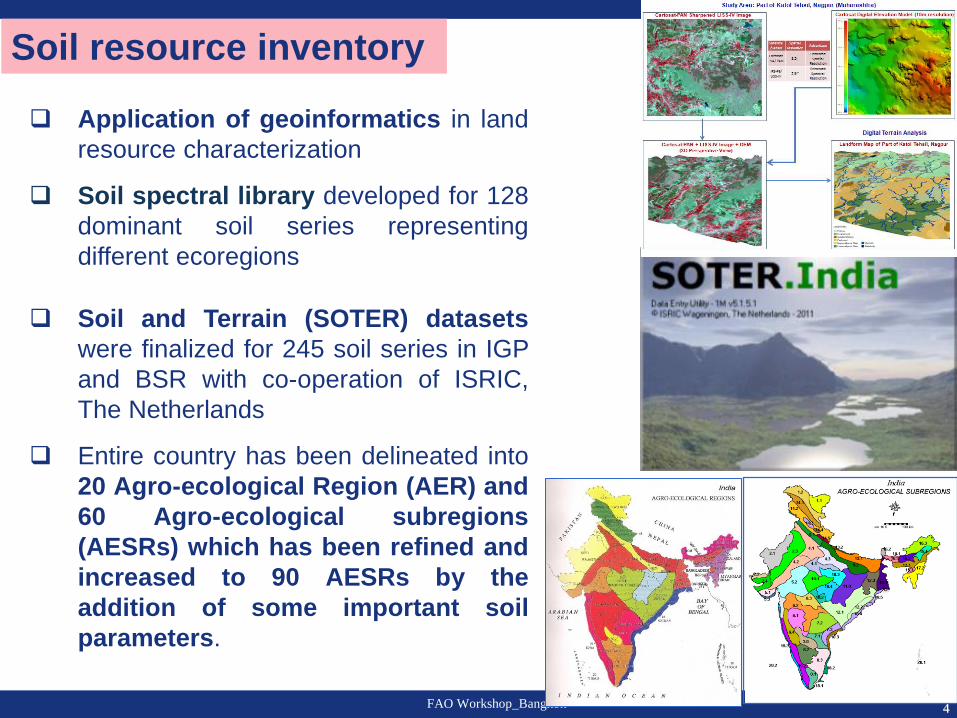
Soil resource inventory
Basic research in soil science
Soil degradation and environmental security
Soil quality and nutrient management
Climate change and soil carbon sequestration
Way Forward
Outline

3 FAO Workshop_Bangkok
Soil map of India at 1:1 m scale with:
- 7 soil orders
- 1649 mapping units
Soil map of all 29 states at 1:250,000
scale (printed on 1:500,000)
Soil information of about 20 million ha
at 1:50,000 scale (71 districts)
A flagship programme to generate
land resource information at 1:10,000
scale initiated
Georeferenced Soil Information
System (GeoSIS, using 850 soil series
information) for two important food
growing areas of India (Indo-Gangetic
Plains and Black Soil Region)
Soil resource inventory
4 FAO Workshop_Bangkok
Application of geoinformatics in land
resource characterization
Soil spectral library developed for 128
dominant soil series representing
different ecoregions
Soil and Terrain (SOTER) datasets
were finalized for 245 soil series in IGP
and BSR with co-operation of ISRIC,
The Netherlands
Entire country has been delineated into
20 Agro-ecological Region (AER) and
60 Agro-ecological subregions
(AESRs) which has been refined and
increased to 90 AESRs by the
addition of some important soil
parameters.
Soil resource inventory
5 FAO Workshop_Bangkok
Basic research in soil science
o Gibbsites were formed in an alkaline environment at an early stages of
weathering.
o Micromorphological studies for pedofeatures and formation of
pedogenic carbonates in the Vertisols of arid and semi-arid climates
leading to subsoil sodicity.
o Mineralogical studies for different soil-size fractions.
o Research on identification of soil-modifiers like zeolites, gypsum
minerals. Presence of zeolites protects the biodiversity of the Western
Ghats and also persistence of Mollisols and Alfisols in Satpura and
Western Ghats
o Quantification of biotite clay minerals and its role in the management of
K-fertilizers
o Use of nanotechnology in soil and crop management, and enhancing
input use efficiency

6 FAO Workshop_Bangkok
Soil degradation and environmental security
About 120.7 mha is degraded
Characterization and mapping of salt
affected soils (6.73 mha)
Characterization and mapping of acid
soils (30.9 mha with pH <5.5)
Reclamation and Management of
problem soils
Bio-remediation/phytoremediation of
contaminated soils

7 FAO Workshop_Bangkok
Soil quality and nutrient management
Development of soil and land quality
indices for major crops
Integrated nutrient management and
input use efficiency
Characterization and prospecting of
large soil biodiversity
Conservation agriculture
Precision agriculture
Research on cropping sequence
under different soil environmental
conditions
Land evaluation and agricultural land
use planning
Benchmark spots (hotspots) for
monitoring soil and land quality
8 FAO Workshop_Bangkok
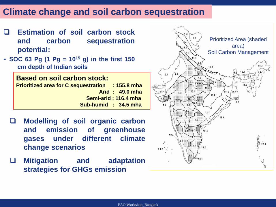
Climate change and soil carbon sequestration
Estimation of soil carbon stock
and carbon sequestration
potential:
- SOC 63 Pg (1 Pg = 1015 g) in the first 150
cm depth of Indian soils
Prioritized Area (shaded
area)
Soil Carbon Management
Based on soil carbon stock: Prioritized area for C sequestration : 155.8 mha
Arid : 49.0 mha
Semi-arid : 116.4 mha
Sub-humid : 34.5 mha
Modelling of soil organic carbon
and emission of greenhouse
gases under different climate
change scenarios
Mitigation and adaptation
strategies for GHGs emission
9 FAO Workshop_Bangkok
Way Forward
Land resource inventory on 1:10,000 scale for the
entire country in phases.
Use of hyperspectral and LiDAR data for hastening
land resource inventory
Basic research to understand the cause-effect
relationships of soil-crop dynamics
Policy for agricultural land use planning
Research on hydro-pedological and pedometrics
Climate resilient/Climate smart agriculture
Refinement of AESRs boundaries of the country
SOTER database for the entire country
Simulation modeling to understand soil physical
processes vis-à-vis climate change
10 FAO Workshop_Bangkok