Embed Size (px)
Citation preview

Solar Radiation - initial source of energy to the Earth. It can be absorbed, reflected and reradiated. The redistribution of this energy controls the structure and dynamics of the Atmosphere and Oceans.
Chapter 8 Circulation of the Atmosphere
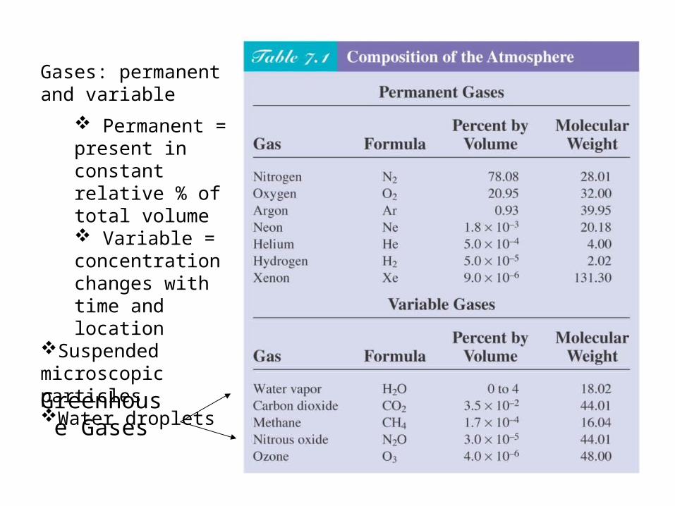
Greenhouse Gases
Gases: permanent and variable
Permanent = present in constant relative % of total volume Variable = concentration changes with time and location
Suspended microscopic particlesWater droplets

The Atmosphere Moves in Response to The Atmosphere Moves in Response to Uneven Solar Heating and Earth’s RotationUneven Solar Heating and Earth’s Rotation
An estimate of the heat budget for Earth. On an average day, about half of the solar energy arriving at the upper atmosphere is absorbed at Earth’s surface. Light (short-wave) energy absorbed at the surface is converted into heat. Heat leaves Earth as infrared (long-wave) radiation. Since input equals output over long periods of time, the heat budget is balanced.

Earth’s Uneven Solar Heating Results in Earth’s Uneven Solar Heating Results in Large-Scale Thermal Cell type of Large-Scale Thermal Cell type of Atmospheric CirculationAtmospheric Circulation
A convection current forms in a room when air flows from a hot radiator to a cold window and back.
Air warms, expands, becomes less dense, and rises over the radiator. Air cools, contracts, becomes more dense, and falls near the cold glass window.
A convection cell is driven by density differences

Enters Co!
Earth’s Uneven Solar Heating Results in Earth’s Uneven Solar Heating Results in Large-Scale Atmospheric CirculationLarge-Scale Atmospheric Circulation
The Coriolis effect is the observed deflection of a moving object, caused by the moving frame of reference on the spinning Earth.
How does this apply to the atmosphere?
As air warms, expands, and rises at the equator, it moves toward the pole, but instead of traveling in a straight path, the air is deflected eastward.
In the Northern Hemisphere air turns to the right.In the Southern Hemisphere air turns to the left.
What factors govern the global circulation of air?
• Uneven solar heating• The Coriolis effect

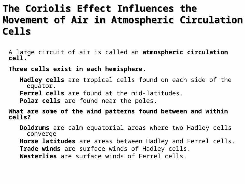
The Coriolis Effect Influences the Movement The Coriolis Effect Influences the Movement of Air in Atmospheric Circulation Cellsof Air in Atmospheric Circulation Cells
Global air circulation as described in the six-cell circulation model. Air rises at the equator and falls at the poles, but instead of one great circuit in each hemisphere from equator to pole, there are three in each hemisphere. Note the influence of the Coriolis effect on wind direction. The circulation show here is idea – that is, a long-term average of wind flow.

Wind bands – Three convection cells in each hemisphere
Trade winds = NE (30°N to 0°) and SE (30°S to 0°)
Westerlies = 60°N to 30°N and 60°S to 30°S
Polar easterlies = 90°N to 60°N and 90°S to 60°S
Low pressure at 0°, 60°N, and 60°S
Low pressure, ascending air, clouds, increased precipitation
High pressure at 30°N, 30°S, 90°N, and 90°SHigh pressure, descending air, clear skies, low precipitation
The Coriolis Effect Influences the Movement The Coriolis Effect Influences the Movement of Air in Atmospheric Circulation Cellsof Air in Atmospheric Circulation Cells
A large circuit of air is called an atmospheric circulation cell.
Three cells exist in each hemisphere.
Hadley cells are tropical cells found on each side of the equator.
Ferrel cells are found at the mid-latitudes.Polar cells are found near the poles.
What are some of the wind patterns found between and within cells?
Doldrums are calm equatorial areas where two Hadley cells converge
Horse latitudes are areas between Hadley and Ferrel cells.Trade winds are surface winds of Hadley cells.Westerlies are surface winds of Ferrel cells.

Sea Breezes and Land Breezes Arise from Sea Breezes and Land Breezes Arise from Uneven Surface HeatingUneven Surface Heating
The flow of air in coastal regions during stable weather conditions.
(a) In the afternoon, the land is warmer than the ocean surface, and the warm air rising from the land is replaced by an onshore sea breeze.
(b) At night, as the land cools, the air over the ocean is now warmer than the air over the land. The ocean air rises. Air flows offshore to replace it, generating an offshore flow (a land breezes).

In the Northern Hemisphere
Air flows clockwise around high pressure systems
Air flows counterclockwise around low pressure systems

Storms Are Variations in Large-Scale Storms Are Variations in Large-Scale Atmospheric CirculationAtmospheric Circulation
Storms are regional atmospheric disturbances. Storms have high winds and most have precipitation.
Tropical cyclones occur in tropical regions. These storms can cause millions of dollars worth of damage and endanger life.
Extratropical cyclones occur in Ferrel cells, and are winter weather disturbances. These storms can also cause extensive damage.
Both types of storms are cyclones, or rotating masses of low-pressure air.

Extratropical Cyclones Form between Two Extratropical Cyclones Form between Two Air MassesAir Masses
(a) The genesis and early development of an extratropical cyclone in the Northern Hemisphere
(b) How precipitation develops in an extratropical cyclone. These relationships between two contrasting air masses are responsible for nearly all the storms generated in the polar frontal zone and thus responsible for the high rainfall within these belts and the decreased salinities of surface waters below.

Tropical Cyclones Form in One Air MassTropical Cyclones Form in One Air Mass
The tracks of tropical cyclones. The breeding grounds of tropical cyclones are shown as orange-shaded areas. The storms follow curving paths: First they move westward with the trade winds. Then they either die over land or turn eastward until they lose power over the cooler ocean of mid-latitudes. Cyclones are not spawned over the South Atlantic or the southeast Pacific because their waters are too chilly; nor in the still air - the doldrums - within a few degrees of the equator.

Chapter 8 - Summary
The interaction of ocean and atmosphere moderates surface temperatures, shapes Earth's weather and climate, and creates most of the sea's waves and currents.
Different amounts of solar energy are absorbed at different latitudes, and this makes the tropics warmer than the polar regions.
Uneven solar heating causes convection currents to form in the atmosphere and leads to areas of different atmospheric pressures. The direction of air flow in these currents is influenced by the rotation of Earth.
To observers on the surface, Earth's rotation causes moving air (or any moving mass) in the Northern Hemisphere to curve to the right of its initial path, and in the Southern Hemisphere to the left. This is known as the Coriolis effect.

Chapter 8 - Summary
The atmosphere responds to uneven solar heating by flowing in three great circulating cells over each hemisphere. The flow of air within these cells is influenced by Earth’s rotation (Coriolis effect). Each hemisphere has three large atmospheric circulation cells: a Hadley cell, a Ferrel cell, and a polar cell (less pronounced over the South Pole).
Large storms are spinning areas of unstable air that develop between or within air masses. Extratropical cyclones originate at the boundary between air masses.
Tropical cyclones, the most powerful of Earth's atmospheric storms, occur within a single humid air mass.

Chapter 9 Circulation of the Ocean

Surface Currents Are Driven by the Winds
The westerlies and the trade winds are two of the winds that drive the ocean’s surface currents.
About 10% of the water in the world ocean is involved in surface currents, water flowing horizontally in the uppermost 400 meters (1,300 feet) of the ocean’s surface, driven mainly by wind friction.
(left) Winds, driven by uneven solar heating and Earth’s spin, drive the movement of the ocean’s surface currents. The prime movers are the powerful westerlies and the persistent trade winds (easterlies).

Surface Currents
What are some effects of ocean currents?
Transfer heat from tropical to polar regionsInfluence weather and climateDistribute nutrients and scatter organisms
Surface currents are driven by wind:
Most of Earth’s surface wind energy is concentrated in the easterlies and westerlies.Due to the forces of gravity, the Coriolis effect, and winds, water often moves in a circular pattern called a gyre.

Surface Currents Are Driven by the Winds
The gyres circulate clockwise in the Northern Hemisphere and counterclockwise in the Southern Hemisphere.
The North Atlantic gyre, a series of four interconnecting currents with different flow characteristics and temperatures.

Surface Currents Flow around the Periphery of Ocean Basins
Surface water blown by the winds at point A will veer to the right of its initial path and continue to the east.
Water at point B veers right and continues to the west.

The Ekman spiral and the mechanism by which it operates.
Surface Currents Flow around the Periphery of Ocean Basins

Surface Currents Flow around the Periphery of Ocean Basins
The surface is raised through wind motion and Ekman transport to form a low hill. The westward-moving water at B ‘feels’ a balanced pull from two forces: the one due to Coriolis effect (which would turn the water to the right) and the one due to the pressure gradient, driven by gravity (which would turn it to the left).
The hill is formed by Ekman transport. Water turns clockwise (inward) to form the dome, then descends, depressing the thermocline.
Consider the North Atlantic.

Seawater Flows in Six Great Surface Circuits
Geostrophic gyres are gyres in balance between the pressure gradient and the Coriolis effect. Of the six great currents in the world’s ocean, five are geostrophic gyres. Note the western boundary currents in this map.

Western boundary currents – These are narrow, deep, warm, fast currents found at the western boundaries of ocean basins.
The Gulf StreamThe Japan CurrentThe Brazil CurrentThe Agulhas CurrentThe Eastern Australian Current
Eastern boundary currents – These currents are cold, shallow and broad, and their boundaries are not well defined.
The Canary CurrentThe Benguela CurrentThe California CurrentThe West Australian CurrentThe Peru Current
Boundary Currents Have Different Characteristics

Boundary Currents Have Different Characteristics
Eddy formation
The western boundary of the Gulf Stream is usually distinct, marked by abrupt changes in water temperature, speed, and direction.
(a) Meanders (eddies) form at this boundary as the Gulf Stream leaves the U.S. coast at Cape Hatteras. The meanders can pinch off (b) and eventually become isolated cells of warm water between the Gulf Stream and the coast (c). Likewise, cold cells can pinch off and become entrained in the Gulf Stream itself (d). (C = cold water, W = warm water; blue = cold, red = warm.)

Boundary Currents Have Different Characteristics
Water flow in the Gulf Stream and the Canary Current, parts of the North Atlantic gyre.

Surface Currents Affect Weather and Climate
Wind induced vertical circulation is vertical movement induced by wind-driven horizontal movement of water.
Upwelling is the upward motion of water. This motion brings cold, nutrient rich water towards the surface.
Downwelling is downward motion of water. It supplies the deeper ocean with dissolved gases.

Nutrient-Rich Water Rises near the Equator
Equatorial upwelling.
The South Equatorial Current, especially in the Pacific, straddles the geographical equator. Water north of the equator veers to the right (northward), and water to the south veers to the left (southward). Surface water therefore diverges, causing upwelling. Most of the upwelled water comes from the area above the equatorial undercurrent, at depths of 100 meters or less.

Wind Can Induce Upwelling near Coasts
Coastal upwelling.
In the Northern Hemisphere, coastal upwelling can be caused by winds from the north blowing along the west coast of a ccontinent. Water moved offshore by Ekman transport is replaced by cold, deep, nutriend-laden water. In this diagram, temperature of the ocean surface is shown in degrees Celsius.

Wind Can Also Induce Upwelling Coastal Downwelling
Coastal downwelling.
Wind blowing from the south along a Northern Hemisphere west coast for a prolonged period can result in downwelling. Areas of downwelling are often low in nutrients and therefore relatively low in biological productivity.

El Niño and La Niña Are Exceptions to Normal Wind and Current Flow
In an El Niño year, when the Southern Oscillation develops, the trade winds diminish and then reverse, leading to an eastward movement of warm water along the equator. The surface waters of the central and eastern Pacific become warmer, and storms over land may increase.
In a non-El Niño year, normally the air and surface water flow westward, the thermocline rises, and upwelling of cold water occurs along the west coast of Central and South America.
An El Niño Year A Non-El Niño Year

Thermohaline Circulation Affects All the Ocean’s Water
The movement of water due to different densities is thermohaline circulation.
Remember that the ocean is density stratified, with the densest water at the bottom. There are five common water masses:
• Surface water = 0-200m• Central water = 200-thermocline• Intermediate water = thermocline-1500m• Deep water = 1500-4000m• Bottom water = 4000-bottom

• Thermohaline Circulation– Vertical, density driven circulation, resulting from
change in temperature and salinity
• Continuity of flow– Water is a relatively fixed quantity in the oceans– Water can not accumulate in one location or be removed
from another location without movement of water between those locations
• Vertical movement of water• Horizontal movement of water

• Ocean water circulates in currents caused mainly by wind friction at the surface and by differences in water mass density beneath the surface zone.
• Water near the ocean surface moves to the right of the wind direction in the Northern Hemisphere, and to the left in the Southern Hemisphere.
• The Coriolis effect modifies the courses of currents, with currents turning clockwise in the Northern Hemisphere and counterclockwise in the Southern Hemisphere. The Coriolis effect is largely responsible for the phenomenon of westward intensification in both hemispheres.
• Upwelling and downwelling describe the vertical movements of water masses. Upwelling is often due to the divergence of surface currents; downwelling is often caused by surface current convergence or an increase in the density of surface water.
Chapter 9 - Summary

• El Niño, an anomaly in surface circulation, occurs when the trade winds falter, allowing warm water to build eastward across the Pacific at the equator.
• Circulation of the 90% of ocean water beneath the surface zone is driven by gravity, as dense water sinks and less dense water rises. Since density is largely a function of temperature and salinity, the movement of deep water due to density differences is called thermohaline circulation.
• Water masses almost always form at the ocean surface. The densest (and deepest) masses were formed by surface conditions that caused water to become very cold and salty.
• Because they transfer huge quantities of heat, ocean currents greatly affect world weather and climate.
Chapter 9 - Summary

Fig. 10-2, p. 266
Direction of wave motion
A B
Wavelength
Height
Still water level Crest Trough
Frequency: Number of wave crests passing point A or point B each second
Orbital path of individual water molecule at water surface
Period: Time required for wave crest at point A to reach point B

Direction of wave motion
Wave-length
Still water levelCrest Trough Crest
1/2 wave-length depth

Seismic disruptionDisturbing forcelandslides
Gravity Wind
Restoring force GravitySurface tension
Type of wave Tide Tsunami Seiche Wind wave Capillary wave (ripple)
24 hr.
Am
ou
nt
of
ener
gy
in o
cean
su
rfac
e
100,000 sec (1 1/4 days)
10,000 sec (3 hr)
1,000 sec (17 min)
100 sec 10 sec 1 sec 1/10 sec 1/100 sec
Period (time, in seconds for two successive wave crests to
pass a fixed point)
1 10 100
Frequency (waves per second)
12 hr.
Period (& wavelength) and Wave Energy

Progressive Waves
Deep- to Shallow-Water Waves

H
L
A
Keep in mind: wave energy, NOT the water particles move across the surface of the sea. Wave propagates with C, energy moves with V
Wave Speed is C - Group Speed is Vwave speed = wavelength / period or C = L / T
T is determined by generating force so it remain the same after the wave formed, but C changes. In general, the longer the wavelength the faster the wave energy will move through the water.
Wave Speed

Deep Water Waves
TgT
LgL
C 56.12
25.12
For example, for a 300 meters wave and 14 sec period, the speed is about 22 meters per second
• Period to about 20 seconds
• Wavelength to at most 600 meters (extreme)
• Speed to about 100 kilometers/hour (70 mi/hr) (extreme)

Deep Water Waves
* surface waves progressing in waters of D larger than 1/2 L
* as the wave moves through, water particles move in circular orbit
* diameter of orbits decrease with depth, orbits do not reach bottom,
particles do not move below a depth D = L/2
* The wave speed can be calculated from knowledge of either the wavelength or the wave period:
C = 1.56 m/s2 T or C2 = 1.56 m/s2 L
* Group Speed (which really transport the energy) is half of the wave speed for deep-water waves: V = C/2

Shallow-Water Waves
Seismic Sea Waves – Shallow-Water Waves
• Period to about 20 minutes
• Wavelength of about 200 kilometers
• Speed of about 750-800 km/hr (close to 500 mi/hr!!)
DgDC 1.3

Shallow-Water Waves• surface waves generated by wind and progressing in waters of D less than (1/20) L • wave motion: as the wave moves through, water particles move in elliptical orbits • diameter of orbits remains the same with depth, orbits do reach the bottom where they ‘flatten’ to just an oscillating motion back and forth along the bottom
* The wave speed and the wavelength are controlled by the depth D of the waters only:
* Group Speed (which transport the energy) is the same as the wave speed for shallow-water waves: V = C
DgDC 1.3

Wind Speed: velocity at which the wind is blowing
Fetch: distance over which the wind is blowing
Duration: length of time wind blows over a given area
Wind Blowing over the Ocean Generates Waves
Waves development and growth are affected by:
Larger Swell Move Faster waves separate into groups
wave separation is called dispersion

• Storm centers and dispersion• Winds flow around low pressure • Variety of periods and heights are generated
grouped into wave trains
Waves with longer period (T) and larger length move faster - these get ahead of the ‘pack’.
Wave sorting of these free waves is dispersion

7 across
1 high
120°
Wave Height, Wavelength & Wave Steepness
Typical ratio wave height to wavelength in open ocean = 1:7 = wave steepness – angle of the crest = 120°
Exceed these conditions and wave will break at sea whitecaps
Wave Height is controlled by (1) wind speed, (2) wind duration and (3) fetch (= the distance over water that the wind blows in the same direction and waves are generated) Significant Wave Height - average wave height of the highest one-third of the waves measured over a long time

1 2
a
b
Constructive interference
(addition)
Destructive interference (subtraction)
Constructive interference
(addition)

Breaker Types
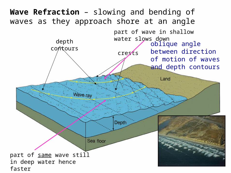
Wave Refraction – slowing and bending of waves as they approach shore at an angle
depth contours
crests
oblique angle between direction of motion of waves and depth contours
part of wave in shallow water slows down
part of same wave still in deep water hence faster

Wave refraction- propagation of waves around obstacles, for example over a shallow ridge – energy is focused (waves get ‘interrupted’, waves generate other waves)
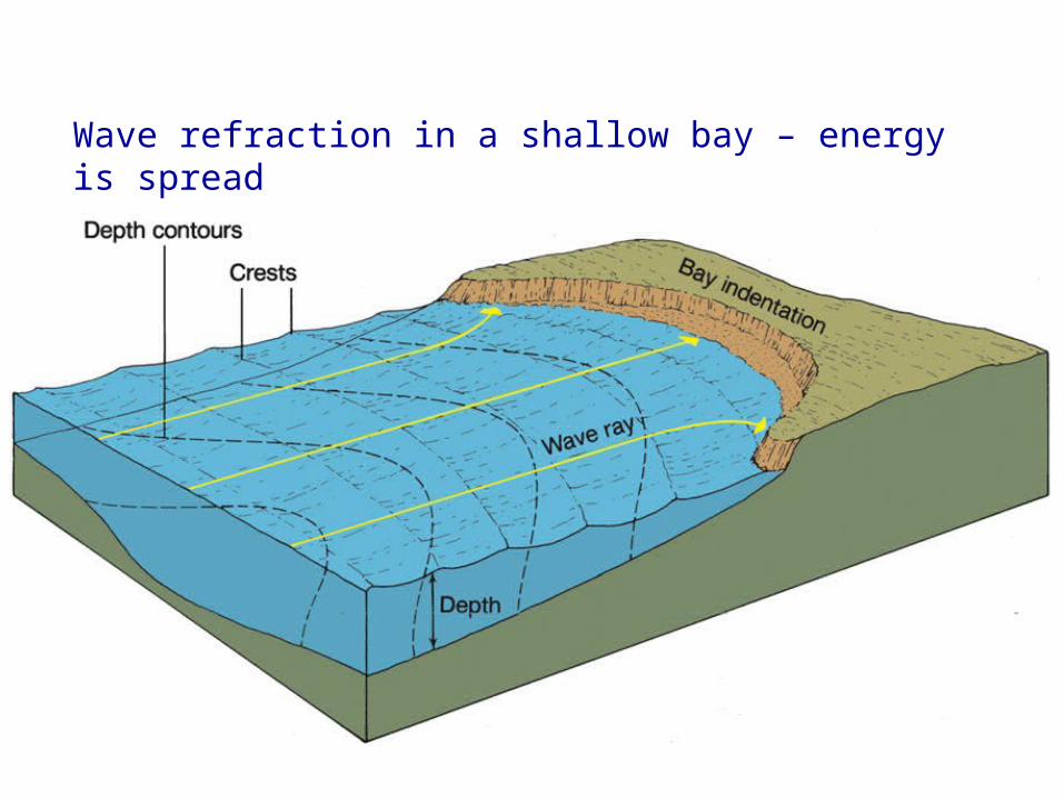
Wave refraction in a shallow bay – energy is spread

Wave Diffraction
narrow opening
diffraction and wave interaction

Tsunamis• Vertical sea floor displacement• Shallow water waves
Long wavelength Low period
• Wave height changes (quite dramatically!) At point of origin Close to shore where depth decreases
when????