Embed Size (px)
Citation preview

TitleSome Geological Results of the Bottom Sampling from the Seaoff Kwanto District Western Margin of the Northern Pacific(Report of the Cruise GDP-1, 1972)
Author(s) Shiki, Tsunemasa; Konda, Isao; Musashino, Makoto; Nishida,Shiro; Yasumatsu, Sadao
Citation Memoirs of the Faculty of Science, Kyoto University. Series ofgeology and mineralogy (1974), 40(2): 95-104
Issue Date 1974-03
URL http://hdl.handle.net/2433/68769
Right
Type Departmental Bulletin Paper
Textversion publisher
Kyoto University

D
~
~ Ib(J 0 ~
~-
0145· 0
0U")
Do 0
ooo1.01
o
~c'{) ~
Taku~Seamountno 0 g~~
o 0 14:700 0 o~b
8o
'T. SHIKI, 1. KaNDA, M. MUSASHINO, S. NISHIDA and S. YASUMATSU
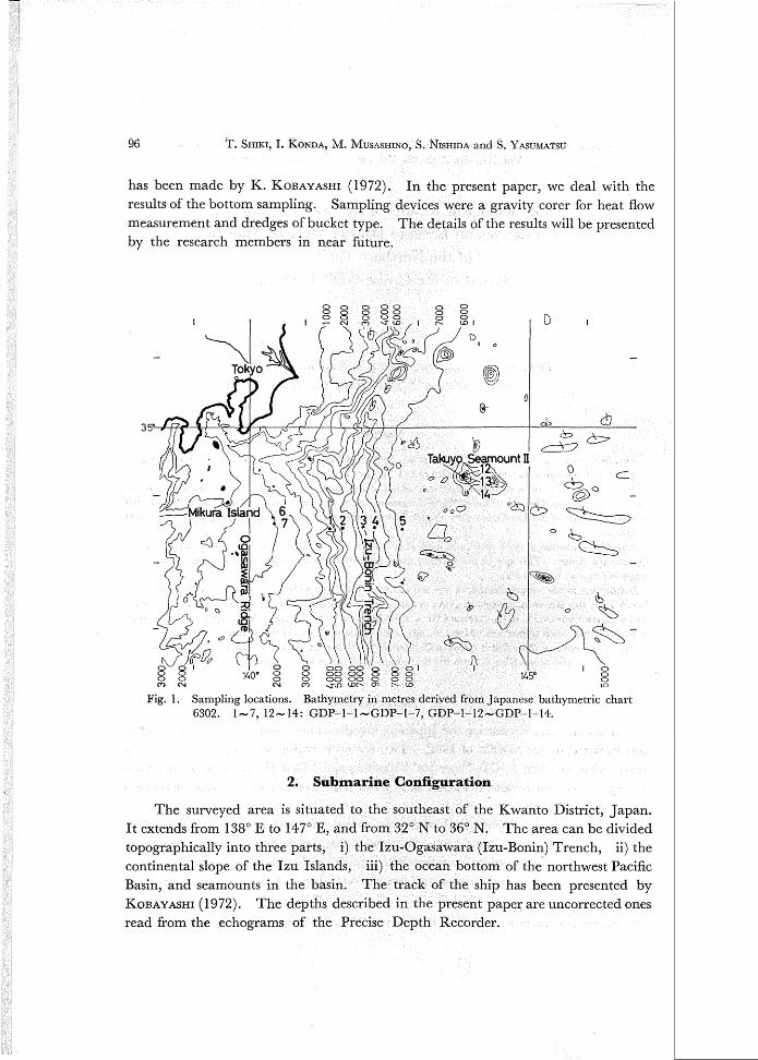
Fig. 1. Sampling locations. Bathymetry in metres derived from Japanese bathymetric chart6302. 1-7,12-14: GDP-I-I-GDP-1-7, GDP-1-12-GDP-1-14.
has been made by K. KOBAYASHI (1972). In the present paper, we deal with theresults of the bottom sampling. Sampling devices were a gravity corer for heat flowmeasurement and dredges of bucket type. The details of the results will be presentedby the research members in near future.
96
2. Submarine Configuration
The surveyed area is situated to the southeast of the Kwanto District, Japan.It extends from 138° E to 147° E, and from 32° N to 36° N. The area can be dividedtopographically into three parts, i) the Izu-Ogasawara (Izu-Bonin) Trench, ii) thecontinental slope of the Izu Islands, iii) the ocean bottom of the northwest PacificBasin, and seamounts in the basin. The track of the ship has been presented byKOBAYASHI (1972). The depths described in the present paper are uncorrected onesread from the echograms of the Precise Depth Recorder.

Sampling from the Sea off Kwanto District 97
3. Sedi:ments
The bottom samplings were made by a gravity corer attached to a heat flow
measuring apparatus, and two dredges of bucket type. Table 1 shows the sampling
position, depth, date, type of apparatus used, and materials obtained at each loca
tion. The results are briefly discussed in the followings.
(1) Izu-Qgasawara TrenchThere were five corings with heat flow measuring at the positions along the line
across the Izu-Ogasawara Trench; two of them were on the west slope
trench, one at the trench bottom, and the other two on the east slope. Two
sediment columns were greenish gray mud, one was greenish olive mud, one
Table 1. Research stations and obtained materials.
Sta. No. Position Depth* Obser- Core Dredged materials Date(m) vation length
GDP-l- 1 33°30.0'N, 5470 Gravity 43 Greenish gray July 27141 0 26.5'E corer -olive gray mud
GDP-l- 2 33°30.0'N, 6750 II 35.5 Greenish grayII141 0 40.0'E -olive gray mud
GDP-l- 3 33°30.0'N, 9020 II 28 Greenish gray Aug.142°00.5'E - greenish olive mud
GDP-l- 4 33°31.3'N, 7610 II 35.8 Dark brown Aug. 2142° 15.4'E -olive brown mud
GDP-l- 5 33°28.5'N, 5940 II 10 Gray muddy sand II142°42.5'E
33°40.9'N, 1260GDP-l- 6 140 0 25.4'E Dredge Med sand with foram., Aug. 6-33°40.5'N,
- 1160haul a few gravels of ss
140 0 26.l'E
GDP-I- 7 33°36.0'N, 980 Sand with foram, scolia,140 0 27.0'E -1045 II anguI. gravels of ss II
34° 18.0'N,
GDP-I-12 143°50.7'E 1440 Sand with granules Aug. 12_34° 18.5'N, II
143°50.5'E
34° 19.2'N, Sand with 3 Mn nodules,143°50.5'E 1420_34° 17.2'N, - 1430
II I scoria, I coral frag., II
143°50.6'E I phos. rock
Sand with Mn nodules,
34°18.6'N, scorias, phos. rocks,
143°50.0'E 1540 II spines of urchins, II
gastropods, teeth of shark,I pelecypod
* UncorrectedNote anguI.: foram. : foraminifers frag. : fragment med: medium Mn: (ferro-)
manganese ss: sandstone phos. : phosphate

'"I
Q
I
T. SHIKI, 1. KONDA, M. MUSASHINO, S. NISHIDA and S. YASUMATSU
Q
I
98

99Sampling from the Sea off Kwanto District
live brown clay, and one was muddy sand. Foraminifers and diatoms wereained in these sediments, but any nannofossil was not preserved.These sediment columns are short but significant. A few bottom samples have
been obtained from the deep bottom of the Izu-Ogasawara Trench. Ryofu-Marucollected a column from the bottom of the Ramapo Deep in the Southern JapanTrench, down to 8,450 m in depth (NASU et at. 1960). GDP-1-3 of the presentreport is greater in water depth of core sampling than that of Ryofu-Maru.
It is remarkable that sandy deposit (Fig. 3) was found on the east slope of thetrench in this cruise. It might be interesting if the sandy deposit of GDP-1-5 shows
e possibility of supply to the present position from the west, prior to the subsidencetrench axis. Such possibility has been suggested by NASU (1964) as one of the
explanations for the occurrence of the coarse sediments on the east slope of the JapanTrench. A great number of sand grains of the present sediment of GDP-1-5, however, seem to be glass and scoria fragments. Since data are insufficient, we cannotdescribe the deposit in detail as yet. Further investigation is necessary.(2) Continental slope of the Izu Islands
It was found from the seismic reflection survey by MURAUCHI and ASANUMAduring this cruise that some basement rock is exposed at the wall of the submarinecanyon which exists to the east of the Mikura Island. For the purpose of obtainingsamples from the exposure, dredging was carried out at three stations. Materialswere obtained at two stations (GDP-1-6, -7) as shown in Table 1. Angular gravelsof calcareous sandstone collected at Station GDP-1-7 are most likely of the fragmentsof the wall rock of the canyon, their maximum size being 4 cm in diameter.
These gravels comprise many microfossils such as foraminifer and nannofossil.The species of planktonic foraminifers significant in the age-consideration fromthese gravels are as follows:
75
50
25
01..,....-==:::e:::.::::---L2--l...--.L---l:5-----L6-==::::::I7=====.....L.S ~
Fig. 3. Weight-pereentage frequency curve of grain size of the
muddy sand of CDP-I-5.

T. SHIKI, 1. KONDA, M. lYfUSASHINO, S. NISHIDA and S. YASUMATSU100
Globigerina bulloides apertula) G. dutertrei, G. eggeri eggeri) G. rubescens) Globorotaliaobliquus extremus, G. pseudomiocenica) Pulleniatina primalis) Sphaeroidinellopsis subdehiscenspaenedehiscens) S. subdehiscens subdehiscens) S. ef. seminulina seminulina etc.
Remarkable calcareous nannofossil species which occurred from the stones areDiscoaster brouweri) D. pentaradiatus) D. surculus) Cyclococcolithusmacintyrei and Reticulqfenestra pseudoumbilica.
From the evidence of the above-mentioned foraminifers and nannofossils, itseems probable that the geological age of the sandstOne gra.velsis<Middle Pliocene.(3) Takuyo Seamount II
Bottom materials were collected by dredge haulsSeamount II (GDP-1-12, -13) and on the slope1-14). The samples obtained are listed in
A large amount of pieces of phosphatecompounds were collected from the samplesThe size of the largest piece was 37 cm in dl<:tmete:rthese pieces and were correlated toin age. They are Watznaueria barnesae)aff. C.disgregatus) Cribrosphaera aff. C. ehrenberginannofossils were replaced by phosphate.
Phosphate rocks also contain small gastropodare phosphatized. These phosphate rocksshallow sea-water, where calcareous se<lu:ne:ntSare collected, however, at a ....pl"'1THPI~T
described.Many spines and tubercles of Sea,-lilrch.lns
pIes. They are like those of Balanocidaris sp.zoic age.
One bivalve fossil was obtained at GDP-1-14, but was not preserved well.Definite identification was impossible.
It is needless to say that the occurrence of these fossils is very'important for thestudy of the history and movement of the seamount and ocean floor around the seamount.
The size and weight of the large ferro-manganese nodules obtained at GDP-1-13, -14 are as shown in Table 2.
Manganese nodules and slabs have been discovered at a few seamounts (KashimaII: 36°02.8' N, 143°32.7' E and "Mizunagi": 37°07.3' N, 145°18.6' E) during theresearch cruise of the Hakuho-Maru KH-69-2, 1969 (ToMoDA and NASU, 1971).Manganese nodules and manganese-coated pumice fragments were also recoveredat E6 (38°06.4'-38°11.2' N, 148°01.0'-147°59.0' E), at the middle of the flat Northwest Pacific Basin, during the Japanese Deep Sea Expedition of 1961 (NASU and SATO,

Sampling from the Sea off Kwanto District 101
1962). The discovery of manganese nodules at the Takuyo Seamount II shouldoffer an interesting additional datum for the problem of distribution and depositionalenvironment of the nodules.
Table 2. Ferro-manganese nodules obtained at GDP-I-13, 14.
Sample No. Size (cm) Weight (kg) Remarksa b c
GDP-I-13 1 27 x23x20 8 Black
2 18x 17x 12 3 One side of the surfaceis remarkably rough.
3 13xllx 9 1.5 Surface is rough.
GDP-I-14 1 30x20x 15 9 Granules and a spongeare attached to the surface.
2 37 X 22 X 17 9 Sponge is attached tothe surface.
3 17 X 11.5 X 6.5 1.5 Pumice thickly coated· bymanganese oxides.
A large number of nodules 4 (in all)
4. Acknowledgtnents
First of all, the writers wish to thank Captain Magoshichi SATO and all thecrew members of the Tokaidaigaku-Maru II, who contributed to the survey bytheir excellent operation and navigation. We are also deeply indebted to the Scientists and students of Tokai University, and Mr. Hideichi TOKUHASHI of Kyoto University, who· cooperated in the work on board. Thanks are due to Prof. SyozaburoNAGUMO of Tokyo University (Chief scientist of the cruise), Prof. Kazuo KOBAYASHIof the same University and other scientists who gave us helpful suggestion and en
couragement during the cruise. Appreciation is expressed to Dr. Atsuyuki MIZUNOof the Geological Survey ofJapan and Prof. Koichiro IOHIKAWA of Osaka City University, for their examination of bivalve fossils, and to Dr. Toshiaki TAKAYAMA ofTohoku University for his helpful discussion on the age determination by foraminifers.The authors are also indebted to Prof. Noriyuki NASU of the Committee of GDP in
Japan and Prof. Tsuhei HOSHINO of the Subcommittee of West Pacific of the Project,and other members of the committees for their hospitality and encouragement.Prof. Tadao KAMEl and Dr. Daikichiro SHIMIZU of Kyoto University also gave ushelpful advice and encouragement. The research has been supported by a Grantin Aid for Fundamental Scientific Research from the Ministry of Education ofJapan.

Explanation of Plate 10Late Cretaceous Nannofossils from the Takuyo Seamount IIElectronmicrographs of carbon replica.Bar scale on each figure represents 1 micron.Figure I. Watznaueria barnesae (BLACK) BUKRY, 1969Figure 2. Cretarhabdus crenulatus crenulatus BRAMLETTE & MARTINI, 1964
Explanation of Plate 11Figure 1. Spines of echinoid: Type 1Figure 2. Spines of echinoid: Type 2Figure 3. Spines of echinoid: Type 3Figure 4. Tubercles of echinoid.Figure 5. Phosphate rock with manganese coating.Figure 6. Cross section of manganese nodule, of which core is phosphate.Figures 1-6 are in natural size.Figure 7. Sandstone fragments at St. GDP-1-7. X 1/3.Figure 8. Thin section of one of the sandstone fragments. X 30.
References
T. SHIKI, I. KONDA, M. MUSASHINO, S. NISHIDA and S. YASUMATSU102
NASU, N. (1964): The provenance of the coarse sediments on the continental shelves and the trenchslopes off the japanese Pacific coast. In R. L. Miller (Editors), Papers in Marine Geology;Shepard Commemorative Volume, The Macmillan Company, New York, 531 p., pp. 55-101.
NASU, N., A. IIJIMA and H. KAGAMI (1960): Geological results in the japanese Deep Sea Expeditionin 1959. Oceanogr. Magazine, Vol. 11, pp. 201-214.
NASU A. and T. SATO (1962): Geological results in the japanese Deep Sea Expedition in 1961(JEDS-4). Oceanogr. Magazine, Vol. 13, pp. 155-166.
KOBAYASHI, K. (1972): Research cruises of Geodynamics Project. Marine Sciences, Vol. 12, pp.61-65, (in japanese with English abstract).
TOMODA, Y. and N. NASU (Ed.) (1971): Preliminary Report of the Hakuho-Maru Cruise KH-69-2,205 p.

pI. 11
4
2
65
1
3
Sci., Kyoto Vniv., Ser. Geol. & Min., Vol. XL, No.2.
et at.: Bottom Sampling from sea off Kwanto District

Kyoto Univ., Ser. Geol. &Min., Vol. XL, No.2.
et al.: Bottom Sampling from sea off Kwanto District