Embed Size (px)
Citation preview

U.S. Department of the InteriorU.S. Geological Survey
Sound Waves Volume FY 2008, Issue No. 104May 2008
Sound Waves C o a s t a l S c i e n c e a n d R e s e a r c h N e w s f r o m A c r o s s t h e U S G S
Fieldwork
http://soundwaves.usgs.gov/
(Coast Salish continued on page 2)
In an exciting new partnership between the Coast Salish (indigenous peoples of the Salish Sea ecoregion) and the U.S. Geological Survey (USGS), members of western Washington Tribes and British Columbia First Nations will measure wa-ter quality in Puget Sound and the Strait of Georgia during their annual summer canoe voyage, the Tribal Journey (URL http://tribaljourneys.com/). Currently, groups paddling more than 100 canoes are plan-ning to set out from locations throughout
Washington State and British Co-lumbia, Canada, and travel during July 2008 along six principal paths to Cowichan, southern Vancouver Island, for the biggest potlatch of the year. The annual Tribal Journey honors the centuries-old traditions of transport and trade by peoples living around the Salish Sea ecoregion—the large inland waterway that encompasses Puget Sound in the United States and the
ceremony for the 2008 North American Indigenous Games (URL http://www.cowichan2008.com/).
This summer, a scientifi c component will be added to the Tribal Journey’s rich array of cultural activities. Four to six of the canoes (the number has yet to be
USGS Will Collaborate with Coast Salish Indigenous Peoples to Measure Water Quality in the Salish Sea (Puget Sound and Strait of Georgia)By Eric Grossman and Helen Gibbons
Installing a water-quality probe and GPS unit on a traditional canoe during a break-out session at the Third Annual Coast Salish Gathering.
Eric Grossman (seated) discusses logistics for data col-lection with (left to right) canoe skipper Eric Day, water quality scientists Rachel Lovellford and Sarah Akin, direc-tor of Offi ce of Planning and Community Development Charlie O'Hara (all from Swinomish Indian Tribal Commu-nity), and USGS hydrologist Paul Schuster at a breakout session at the Third Annual Coast Salish Gathering.
Testing the equipment.
Strait of Georgia in Canada. Historically, Coast Salish people traveled the waters to meet and gather for festivities. Use of traditional water routes was revitalized in 1989, and the modern summer Tribal Journey is now an important event for many Tribes and First Nations. The landing of the Tribal Journey at Cowichan will also serve as the opening

2May 2008 Sound Waves
Sound Waves
EditorHelen Gibbons
Menlo Park, CaliforniaTelephone: (650) 329-5042
E-mail: [email protected]: (650) 329-5190
Print Layout EditorsSusan Mayfi eld, Sara Boore
Menlo Park, CaliforniaTelephone: (650) 329-5066
E-mail: smayfi [email protected]; [email protected]: (650) 329-5051
Web Layout EditorJolene Shirley
St. Petersburg, FloridaTelephone: (727) 803-8747 Ext. 3038
E-mail: [email protected]: (727) 803-2032
SOUND WAVES (WITH ADDITIONAL LINKS) IS AVAILABLE ONLINE AT URLhttp://soundwaves.usgs.gov/
Fieldwork
Fieldwork, continued
(Coast Salish continued from page 1)
Submission Guidelines
Deadline: The dead line for news items and pub li ca tion lists for the August issue of Sound Waves is Wednesday, June 11. Publications: When new publications or prod ucts are re leased, please no ti fy the ed i tor with a full reference and a bulleted sum ma ry or description.Images: Please sub mit all images at pub li ca tion size (col umn, 2-column, or page width). Resolution of 200 to 300 dpi (dots per inch) is best. Ado be Illustrator© fi les or EPS fi les work well with vector fi les (such as graphs or di a grams). TIFF and JPEG fi les work well with ras ter fi les (pho to graphs or rasterized vec tor fi les).
Any use of trade, fi rm, or product names is for descriptive purposes only and does not imply endorsement by the U.S. Gov ern ment.
U.S. Geological Survey Earth Science Information Sources:
Need to fi nd natural-science data orinformation? Visit the USGS Frequently Asked Ques tions (FAQ’s) at URL http://www.usgs.gov/search/faq.html
Can’t fi nd the answer to your question on the Web? Call 1-888-ASK-USGS
Want to e-mail your question to the USGS?Send it to this address: [email protected]
(Coast Salish continued on page 3)
fi nalized) will carry water-quality probes and Global Positioning System (GPS) units on each of four to six of the princi-pal routes to Cowichan. The probes will measure surface-water temperature, con-ductivity (salinity), pH, dissolved oxygen, total dissolved solids, and turbidity. Upon completion of the Tribal Journey, the data will be downloaded and used to compile a database of water-quality measurements across the Salish Sea, maps, geographic-information-system (GIS) data layers, and reports that will help Tribal, Federal, State, and local entities identify water-quality issues and ultimately manage Sal-ish Sea resources. USGS geologist Eric Grossman has been invited by the Coast Salish to provide scientifi c advice and technical expertise in planning and con-ducting the study and analyzing the data.
“The annual Tribal Journey of the Coast Salish offers a unique and unprec-edented opportunity to measure the pulse of the Salish Sea’s environmental health,” said Grossman, who has been study-ing the effects of urbanization on water quality and habitat in Puget Sound (for example, see “Deltaic Habitats in Puget Sound—Natural Versus Human-Related Change,” Sound Waves, December 2004/January 2005, URL http://soundwaves.usgs.gov/2005/01/fi eldwork3.html). Grossman and Coast Salish partners are excited about the upcoming project. Grossman notes that at the end of this summer’s Tribal Journey, the Coast Sal-ish and the USGS “will be able to map out data captured simultaneously across a broad expanse of the Salish Sea.” The data will provide a snapshot of condi-tions during summer 2008 that “we can compare with processes that affect water quality throughout the region—such as river discharge, tides, winds, currents, and coastal upwelling—and with future mea-surements along successive journeys.”
The feasibility of conducting water-quality studies during a canoe voyage like the summer 2008 Tribal Journey was suc-cessfully demonstrated during a 1,200-mi-long canoe trip down the Yukon River in summer 2007. The Yukon River Healing Journey—from Moosehide, Yukon Terri-
George Adams, canoe skipper for the Nooksack Indian Tribe, holding a water-quality probe.
ContentsFieldwork 1Research 5Meetings 7Awards 9Staff and Center News 10Publications 12
3 Sound Waves May 2008Fieldwork
(Coast Salish continued from page 2)
Fieldwork, continued
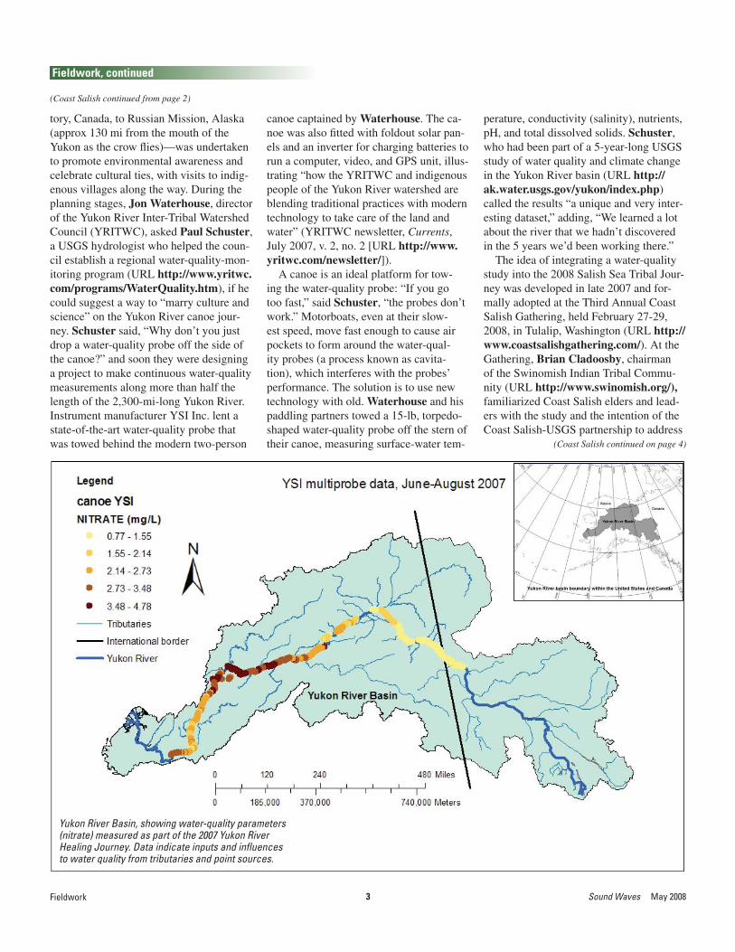
tory, Canada, to Russian Mission, Alaska (approx 130 mi from the mouth of the Yukon as the crow fl ies)—was undertaken to promote environmental awareness and celebrate cultural ties, with visits to indig-enous villages along the way. During the planning stages, Jon Waterhouse, director of the Yukon River Inter-Tribal Watershed Council (YRITWC), asked Paul Schuster, a USGS hydrologist who helped the coun-cil establish a regional water-quality-mon-itoring program (URL http://www.yritwc.com/programs/WaterQuality.htm), if he could suggest a way to “marry culture and science” on the Yukon River canoe jour-ney. Schuster said, “Why don’t you just drop a water-quality probe off the side of the canoe?” and soon they were designing a project to make continuous water-quality measurements along more than half the length of the 2,300-mi-long Yukon River. Instrument manufacturer YSI Inc. lent a state-of-the-art water-quality probe that was towed behind the modern two-person
canoe captained by Waterhouse. The ca-noe was also fi tted with foldout solar pan-els and an inverter for charging batteries to run a computer, video, and GPS unit, illus-trating “how the YRITWC and indigenous people of the Yukon River watershed are blending traditional practices with modern technology to take care of the land and water” (YRITWC newsletter, Currents, July 2007, v. 2, no. 2 [URL http://www.yritwc.com/newsletter/]).
A canoe is an ideal platform for tow-ing the water-quality probe: “If you go too fast,” said Schuster, “the probes don’t work.” Motorboats, even at their slow-est speed, move fast enough to cause air pockets to form around the water-qual-ity probes (a process known as cavita-tion), which interferes with the probes’ performance. The solution is to use new technology with old. Waterhouse and his paddling partners towed a 15-lb, torpedo-shaped water-quality probe off the stern of their canoe, measuring surface-water tem-
perature, conductivity (salinity), nutrients, pH, and total dissolved solids. Schuster, who had been part of a 5-year-long USGS study of water quality and climate change in the Yukon River basin (URL http://ak.water.usgs.gov/yukon/index.php) called the results “a unique and very inter-esting dataset,” adding, “We learned a lot about the river that we hadn’t discovered in the 5 years we’d been working there.”
The idea of integrating a water-quality study into the 2008 Salish Sea Tribal Jour-ney was developed in late 2007 and for-mally adopted at the Third Annual Coast Salish Gathering, held February 27-29, 2008, in Tulalip, Washington (URL http://www.coastsalishgathering.com/). At the Gathering, Brian Cladoosby, chairman of the Swinomish Indian Tribal Commu-nity (URL http://www.swinomish.org/), familiarized Coast Salish elders and lead-ers with the study and the intention of the Coast Salish-USGS partnership to address
Yukon River Basin, showing water-quality parameters (nitrate) measured as part of the 2007 Yukon River Healing Journey. Data indicate inputs and infl uences to water quality from tributaries and point sources.
(Coast Salish continued on page 4)

4May 2008 Sound Waves
Fieldwork, continued
Fieldwork
(Coast Salish continued from page 3)
issues related to the recent deterioration of ancestral waterways and marine re-sources that for millennia have sustained the Coast Salish. Among the goals of the Coast Salish Gathering were to integrate the diverse indigenous peoples of the Sal-ish Sea under one Coast Salish voice and to adopt an environmental science and policy agenda that will help the Coast Sal-ish sustain their environment and marine resources, which are closely linked to their culture and identity.
During the Gathering, Coast Salish elders and leaders, and scientists from Tribes, First Nations, academia, and nu-merous agencies—including the U.S. Environmental Protection Agency (URL http://www.epa.gov/), Environment Canada (URL http://www.ec.gc.ca/), and Parks Canada (http://www.pc.gc.ca/)—highlighted critical impacts to nearshore ecosystems that mirror problems identifi ed by the Puget Sound Nearshore Partnership (URL http://www.pugetsoundnearshore.org/). These impacts include historical changes in fi sh-, bird-, plant-, and inver-tebrate-community structure; increases in parasites (sea lice) and invasive species; sedimentation impacts to shellfi sh-har-vest areas and fi sh migratory pathways; impacts of trawling on benthic ecosystem structure and function; and increases in pollution from both point and nonpoint sources, especially wood-pulp mills, metal refi neries, and dairy farms. Improving our understanding, and ability to predict the extent, of these impacts to nearshore habitats, estuarine processes, and marine resources is the principal mission of the USGS Coastal Habitats in Puget Sound Project (URL http://puget.usgs.gov/), in cooperation with its many partners.
“The Coast Salish have extensive tradi-tional ecological knowledge of their envi-ronment and patterns of change across the Salish Sea,” said Grossman, noting that the plan to collect water-quality data dur-ing the 2008 Tribal Journey “will provide a unique opportunity to use traditional ecological knowledge and western sci-ence to improve understanding of ongo-ing change to the region’s ecologic and cultural resources and the processes that affect them.”
Grossman will serve as scientifi c advi-sor to Coast Salish for the Tribal Journey, and Sarah Akin of the Swinomish Indian Tribal Community will serve as project coordinator. Grossman and Akin have been conducting workshops for Coast Sal-ish participants in preparation for the Trib-
al Journey. To learn more about the Tribal Journey, visit URL http://tribaljourneys.wordpress.com/tribal-journeys-of-the-nw/. To learn more about the history, peoples, and mission of the Coast Salish, visit URL http://www.coastsalishgathering.com/.]
PathwaysLaunch Sites2008 destination
Seattle
Summer 2007 Tribal Journey, in which 88 Native American Tribes from Washington State and First Nations of British Columbia, Canada, paddled along several pathways to a common host destination at Lummi, Washington, over the course of 3 to 4 weeks. Red star, summer 2008 destination: Cowichan, British Columbia, Canada. (Routes in 2008 may differ from those in 2007.)

5 Sound Waves May 2008Research
Research
(Sea-Otter Diets continued on page 6)
Sea-Otter Study Reveals Striking Variability in Diets and Feeding StrategiesBy Tim Stephens, University of California, Santa Cruz
Ecologists have long observed that when food becomes scarce, animal populations exploit a wider range of food sources. So scientists studying southern sea otters at different sites in California’s coastal waters were not surprised to fi nd that the dietary diversity of the population is higher where food is limited. But this diversity was not refl ected in the diets of individual sea otters, which instead showed dietary specialization in response to limited food.
The new fi ndings by researchers at the University of California, Santa Cruz (UCSC) and the U.S. Geological Survey (USGS) were published in a paper in the Proceedings of the National Academy of Sciences for January 15, 2008 (URL http://www.pnas.org/cgi/content/abstract/105/2/560). The study found that all sea otters in an area with abundant food resources share the same dietary preferences. Where food is limited, however, a diverse array of feeding strategies emerges, with individual sea otters specializing on particular types of prey.
Tim Tinker, a USGS research ecologist (and research fellow at UCSC) and the fi rst author of the paper, said that the study has both theoretical implications for the science of ecology and practical implications for wildlife management.
“The traditional way of viewing the relationships between predators and prey and how food webs are structured may be oversimplifi ed,” Tinker said. “When you look at the population as a whole, you may see a diversifi cation of the diet in response to limited food resources. But when you look at individuals, you see dietary specialization.”
One implication of this dietary specialization for California sea otters is that some otters may be exposed to certain food-borne pathogens much more frequently than otters with different diets. “A lot of sea otters in the central-coast population are dying from infectious
diseases, and this could help us to better understand that disease mortality by allowing us to pinpoint the specifi c vectors of disease transmission,” Tinker said.
Tinker’s coauthors are Gena Bentall, who worked on the study as a UCSC graduate student and is now with the Monterey Bay Aquarium’s sea-otter research and conservation group; and James Estes, who worked on this study as a USGS wildlife ecologist (now retired) and is now professor of ecology and evolutionary biology at UCSC and interim director of the STEPS (Science, Technology, Engineering, Policy, and Society) Institute at UCSC. The study compared sea otters on the central California coast, which has the largest population of southern sea otters, with those in a much smaller population around San Nicolas Island off the southern California coast.
The San Nicolas population is the result of an effort by the U.S. Fish and Wildlife Service to reduce the vulnerability of California sea otters to oil spills by establishing a separate population from the main one on the central coast. In the late 1980s, about 140 sea otters were relocated to San Nicolas Island. Most of them soon returned to the mainland, but the few that remained have prospered. With plenty of food to go around, the San Nicolas otters are in better shape than their mainland counterparts, and their population is now growing much faster than the central-coast population.
“The San Nicolas otters are much bigger than the mainland animals, their body condition is better, and they spend less time feeding,” Tinker said. “When we looked at individual diets, a few key prey types
Tim Tinker observes radio-tagged sea otters off the coast of central California. Tinker and his team use radio telemetry to locate a study animal in a kelp bed, and then use high-powered telescopes to gather data on feeding behavior and diet. Photograph by Ian Adams (Corvus Consulting, British Columbia, Canada).

6May 2008 Sound Waves Research
(Sea-Otter Diets continued from page 5)
Research, continued
dominated, and each otter’s diet looked pretty much like every other otter’s diet.”
The otters’ preferred prey are large, energy-rich red sea urchins, which are abundant around San Nicolas Island. On the central coast, red sea urchins are much less common than the smaller purple sea urchins. The San Nicolas otters also eat marine snails and crabs, but there is little difference between the population as a whole and individual otters in terms of dietary diversity. Each otter is a generalist, with the same preferences as other otters.
The mainland otter population is strikingly different. Although the diet of the population as a whole is much more diversifi ed than at San Nicolas, individual diets are more specialized. Estes said it
Tim Tinker haul-ing in a freshly caught sea otter off Cypress Point, south of Monterey Bay on the central California coast. The otter will be examined, radio-tagged, and released. Tinker and team will collect a comprehensive suite of behav-ioral and life-his-tory data from this animal over the next 2 to 3 years, includ-ing a detailed description of the animal’s diet. Photograph by Tom Suchanek (USGS), April 3, 2008.
is not surprising that animals are highly individual in the way they feed, but the link between individual specialization and resource availability is new.
“What’s new in this paper is that individuality is a plastic characteristic that emerges when resources become limited,”Estes said. “We’re seeing this in sea otters, but it probably occurs broadly in nature. It may apply to people, too. When there were just a few people running around on the face of the Earth, they were probably all doing pretty much the same thing.”
Individuality in feeding behavior adds a new level of complexity to the dynamics of food webs. For wildlife managers, it means that each animal has to be considered as an individual and may not
be representative of the whole population. But the fi ndings also suggest a potentially useful tool for assessing the status of wildlife populations, Estes said.
“It’s very hard to know where a population stands with respect to resource limitation; we’re always asking if a population is limited by the availability of food,” he said. “We could conceivably look for individuality in foraging behavior as an indication that food limitation is an important factor.”
According to Estes, scientists were already convinced before this study was completed that the availability of food is limiting the central-coast sea-otter population. He said that the same situation probably prevailed throughout California before fur traders began hunting sea otters in the 18th century, eventually driving them to the brink of extinction. But it’s not clear why sea otters aren’t spreading out into other areas along the California coast where they would fi nd more food than on the central coast.
“Why this population does not expand into food-rich areas is one of the perplexing challenges we haven’t been able to fi gure out,” Estes said.
The full citation for the new paper is:Tinker, M.T., Estes, J.A., and Bentall,
G., 2008, Food limitation leads to behav-ioral diversifi cation and dietary special-ization in sea otters: Proceedings of the National Academy of Sciences, v. 105, no. 2, p. 560-565 [URL http://www.pnas.org/cgi/content/abstract/105/2/560].
About the author: Article author Tim Stephens, who holds degrees from the Uni-versity of California, Santa Barbara (B.A., botany), and Cornell University (M.S., plant pathology), is a science writer in the UCSC Public Information Offi ce.]

7 Sound Waves May 2008
Meetings
Meetings
(India Water Quality continued on page 8)
Rapid population growth and development are occurring in many coastal areas of Goa—India’s smallest state, situated on the central west coast of the subcontinent. As sea levels rise over the next half-century and beyond, coastal regions will become more vulnerable to shoreline erosion, saltwater intrusion into coastal aquifers, increased incursion of tides in coastal rivers, microbiological and chemical contamination, and more frequent coastal fl ooding. India is currently undergoing tremendous economic growth, the extent and sustainability of which will be limited if safe and reliable drinking-water resources are unavailable. Both natural increases in the rates of coastal change and development pressures in the coastal zone are resulting in an urgency to formulate an adequate response strategy for the sustainable development of coastal areas.
To address these issues, 10 scientists from India and the United States met in Goa, India, March 17-21, 2008, to discuss the establishment of an International Partnership for Coastal Water Resources(IPCWR; URL http://www.ipcwr.org). The workshop, which was hosted by The
USGS Participates in India-U.S. Coastal Water-Quality WorkshopBy Cheryl Hapke and Thomas Boving
Energy and Resources Institute (TERI; URL http://www.teriin.org/), included researchers from government, academia, and the private sector. The primary goal of this workshop was to strengthen existing multi-institutional links between Indian and U.S. researchers and to formalize
& Technology Forum (URL http://www.indousstf.org/). U.S. workshop participants included U.S. Geological Survey (USGS) scientist Cheryl Hapke(USGS Patuxent Wildlife Research Center’s Coastal Research Field Station at the University of Rhode Island), William
Some workshop participants: (front row) Debashis Acharya, S.C. Gupta, Cheryl Hapke, Buvana Ramaswamy, Veerabaswant Reddy, Sunder-rajan Krish-nan, William Blanford; (back row) Thomas Boving, B.S. Choudri, Kavita Hawaldar, A.L. Ramanathan. The meeting was held in the TERI conference facility.
India, showing the states of Goa (red), where the workshop was held, and neighboring Karna-taka (light green), where the workshop team took a fi eld trip.
Thomas Boving (back left) discusses a water-quality-remediation project with students at the Bangurnagar Degree College in Dandeli, Kar-nataka. Students from the college conducted a recent survey in local villages to identify water-quality issues.
the design of a new interdisciplinary center focused on research related to water quality and remediation technology in coastal areas. The workshop was organized by Thomas Boving (Department of Geosciences, University of Rhode Island) and B.S. Choudri (TERI) and was funded in part by the Indo-US Science

8May 2008 Sound Waves
Meetings, continued
(India Water Quality continued from page 7)
Meetings
Blanford (Department of Geology and Geophysics, Louisiana State University), and Buvana Ramaswamy (CDM [Camp, Dresser and McKee, Inc.]). In addition to Choudri, four Indian researchers with expertise ranging from hydrogeochemistry to human health participated in the workshop. During the workshop, each participant gave a presentation in his or her area of expertise, and discussions took place regarding the vision, mission, and focus of the proposed center.
A fi eld trip was organized to provide all participants with a better understanding of the water-quality issues in Goa and the neighboring state of Karnataka. The team visited the town of Dandeli in northwestern Karnataka to experience fi rsthand the polluted Kali River. Upon arrival in Dandeli, Boving and Choudrigave presentations at the Bangurnagar Degree College, outlining the purpose of the new center and exploring possible future collaborative efforts between the center and the college. Students then gave
Proposed location of a riverbank-fi ltration system along the Kali River near Dandeli, Karnataka. At this site, effl uent from a large paper mill discharges into the river (note line of color change just beyond small island). In May 2008, Tom Boving, Bill Blanford, and B.S. Choudri plan to begin the installation of the fi ltra-tion system, which will help to provide clean, effl uent-free water to the local village.
presentations on a water-quality survey carried out around the Kali River and shared their experiences on water quality, the local community’s perception of issues related to water management, and the need for remediation of Kali River water. After the presentations, the team visited a few sites along the Kali River, including the source of pollution and the site of a planned riverbank-fi ltration system.
Before and immediately after the 5-day workshop, Hapke, Boving, and Blanfordvisited several sites to characterize the varied geomorphology of the Goa coastline and to explore future research sites and opportunities. The 105-km-long Goa coast is ideal for a pilot study for developing methods of measuring and predicting coastal change in India because it has sandy beaches, rocky headlands, and soft, eroding bluffs. In addition to conducting site visits along the coast, Hapke met with Pravin Kunteof the National Institute of Oceanography (URL http://www.nio.org/jsp/indexNew.jsp) in Dona Paula, Goa, to discuss future research collaborations.]
Varied geomorphology of the Goa coastline: (right) wide expanse of sandy beach at Palolem, South Goa; (below) rocky headlands surrounding a small pocket beach at Co-lomb Beach, South Goa; (far right) bluff failure of the soft laterite cliffs at Anjuna Beach, North Goa, threatening a res-taurant built on the bluff top.
9 Sound Waves May 2008
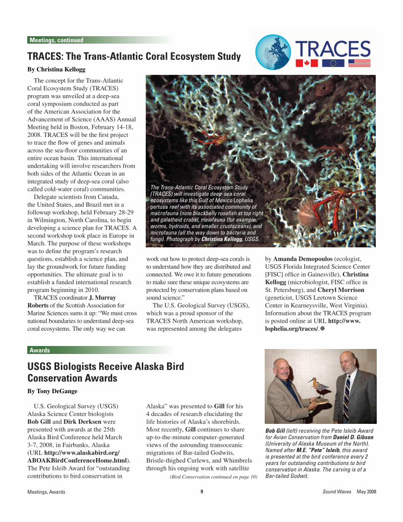
The concept for the Trans-Atlantic Coral Ecosystem Study (TRACES) program was unveiled at a deep-sea coral symposium conducted as part of the American Association for the Advancement of Science (AAAS) Annual Meeting held in Boston, February 14-18, 2008. TRACES will be the fi rst project to trace the fl ow of genes and animals across the sea-fl oor communities of an entire ocean basin. This international undertaking will involve researchers from both sides of the Atlantic Ocean in an integrated study of deep-sea coral (also called cold-water coral) communities.
Delegate scientists from Canada, the United States, and Brazil met in a followup workshop, held February 28-29 in Wilmington, North Carolina, to begin developing a science plan for TRACES. A second workshop took place in Europe in March. The purpose of these workshops was to defi ne the program’s research questions, establish a science plan, and lay the groundwork for future funding opportunities. The ultimate goal is to establish a funded international research program beginning in 2010.
TRACES coordinator J. Murray Roberts of the Scottish Association for Marine Sciences sums it up: “We must cross national boundaries to understand deep-sea coral ecosystems. The only way we can
TRACES: The Trans-Atlantic Coral Ecosystem StudyBy Christina Kellogg
work out how to protect deep-sea corals is to understand how they are distributed and connected. We owe it to future generations to make sure these unique ecosystems are protected by conservation plans based on sound science.”
The U.S. Geological Survey (USGS), which was a proud sponsor of the TRACES North American workshop, was represented among the delegates
by Amanda Demopoulos (ecologist, USGS Florida Integrated Science Center [FISC] offi ce in Gainesville), Christina Kellogg (microbiologist, FISC offi ce in St. Petersburg), and Cheryl Morrison(geneticist, USGS Leetown Science Center in Kearneysville, West Virginia). Information about the TRACES program is posted online at URL http://www.lophelia.org/traces/.]
The Trans-Atlantic Coral Ecosystem Study (TRACES) will investigate deep-sea coral ecosystems like this Gulf of Mexico Lophelia pertusa reef with its associated community of macrofauna (note blackbelly rosefi sh at top right and galatheid crabs), meiofauna (for example, worms, hydroids, and smaller crustaceans), and microfauna (all the way down to bacteria and fungi). Photograph by Christina Kellogg, USGS.
Meetings, Awards
Meetings, continued
(Bird Conservation continued on page 10)
Awards
USGS Biologists Receive Alaska Bird Conservation AwardsBy Tony DeGange
Bob Gill (left) receiving the Pete Isleib Award for Avian Conservation from Daniel D. Gibson (University of Alaska Museum of the North). Named after M.E. “Pete” Isleib, this award is presented at the bird conference every 2 years for outstanding contributions to bird conservation in Alaska. The carving is of a Bar-tailed Godwit.
U.S. Geological Survey (USGS) Alaska Science Center biologists Bob Gill and Dirk Derksen were presented with awards at the 25th Alaska Bird Conference held March 3-7, 2008, in Fairbanks, Alaska (URL http://www.alaskabird.org/ABOAKBirdConferenceHome.html). The Pete Isleib Award for “outstanding contributions to bird conservation in
Alaska” was presented to Gill for his 4 decades of research elucidating the life histories of Alaska’s shorebirds. Most recently, Gill continues to share up-to-the-minute computer-generated views of the astounding transoceanic migrations of Bar-tailed Godwits, Bristle-thighed Curlews, and Whimbrels through his ongoing work with satellite
10May 2008 Sound Waves
(Bird Conservation continued from page 9)
Awards, Staff and Center News
Awards, continued
Staff and Center News
telemetry (see URL http://alaska.usgs.gov/science/biology/shorebirds/). Derksen was honored and recognized for establishing and continuing the Alaska Bird Conference, which has advanced the science and communication of bird research in Alaska for 25 years. Both awardees were honored at a banquet on March 6.]
Dirk Derksen (left) receiving an award from Philip Martin (U.S. Fish and Wildlife Service [USFWS]) for his vision and role in creating the fi rst Alaska Bird Conference. The award is a framed photograph of a King Eider, taken by USFWS employee Ted Swem. Martin also presented an award to Tom Melius (USFWS) for his agency’s role in supporting the start and continuation of the Alaska Bird Conference.
Sea-Otter Expert Joins USGS StaffBy Gloria Maender
Tim Tinker has joined the U.S. Geological Survey (USGS) Western Ecological Research Center (WERC) as its new-est research ecologist. Tinker will lead the center’s sea-otter-research program, previously directed by Jim Estes, who re-cently retired from the USGS. Formerly a research biologist with the Department of Ecology and Evolutionary Biology at the University of California, Santa Cruz (UCSC), Tinker has been studying sea-otter populations for 15 years in Alaska, California, and, most recently, the Russian Commander Islands. Working with Estes, Tinker played a key role in learning about the causes and effects of the sea-otter popu-lation decline in the Aleutian archipelago through the 1990s, and continues to study these threatened populations. More recently, he has also focused on the foraging ecology and demog-raphy of the threatened southern sea otter, investigating how the dynamics of individual animal behavior, food-web interactions, and anthropogenic influences act together to regulate sea-otter
tario, Canada (1993), and a B.Sc. in zoology from the University of Guelph, Ontario, Canada (1989). Tinker’s specialties include quan-titative conservation ecology, with a particular emphasis on modeling population dynamics. He is also interested in individual behavioral strategies, particularly forag-ing specializations, and seeks to understand how variation in the fi tness of individual strategies scales upward to population- and community-level dynamics.
The USGS WERC sea-otter program is headquartered at the Santa Cruz Field Station (URL http://www.werc.usgs.gov/santacruz/), whose offi ces are on the UCSC campus, with a satellite offi ce, Piedras Blancas, in San Luis Obispo County.
Tinker delivered the USGS evening public lecture in Menlo Park, California, on September 27, 2007: “A Tale of Two Kelp Forests: Sea Otters and Ecosystem Dynamics in the Aleutians and the Commander Islands.” A short article about the lecture was published in Sound Waves, September 2007, URL http://soundwaves.usgs.
Labwork without the lab: Tim Tinker pipettes a blood sample taken from a Russian sea otter while trying to stay warm in a tiny cabin on the shores of the Bering Sea in winter. Tinker is one of the principal investigators in a cooperative U.S.-Russian effort to study the thriving sea-otter population in this remote corner of the world, in the hopes of gathering clues about the collapse of neighboring sea-otter populations in Alaska’s Aleutian Islands.
populations in central California (for example, see “Sea-Otter Study Reveals Striking Variability in Diets and Feed-ing Strategies,” this issue).
Tinker earned his Ph.D. in ecology and evolutionary biology at UCSC in 2004. He also holds an M.S. in biology from the University of Waterloo, On-
gov/2007/09/outreach.html, and the lecture can be viewed online through a link posted at URL http://online.wr.usgs.gov/calendar/2007.html.]

11 Sound Waves May 2008
Staff and Center News, continued
Staff and Center News
New Group of Mendenhall Postdoctoral Research Fellows Includes Seven Conducting Coastal and Marine Research
The U.S. Geological Survey (USGS) will welcome a new group of USGS Mendenhall Postdoctoral Research Fellows on October 1, 2008, the start of the Federal Government’s fi scal year 2009 (FY09). Of the 14 postdoctoral researchers in the class of FY09, 7 will be conducting research on coastal and marine topics:
• Serena Moseman (Scripps Institution of Oceanography, University of California, San Diego) will work with Kevin Kroeger, John Crusius, and John Bratton of the USGS Coastal and Marine Geology Program and Eric Sundquist of the USGS Water Resources Discipline’s National Research Program on “Greenhouse Gas Fluxes from the Land/Sea Margin and the Coastal Zone.” Serena will be stationed at the USGS Woods Hole Science Center in Woods Hole, Massachusetts.
• Christopher Smith (Louisiana State University) will work with Peter Swarzenski and Richard Poore of the USGS Coastal and Marine Geology Program on “An Interdisciplinary (Geologic, Hydrologic and Biologic) Investigation of the Processes Controlling Florida’s Harmful Algal Blooms (HABs).” Christopher will be stationed at the USGS Florida Integrated Science Center offi ce in St. Petersburg.
• Ryan Moyer (Ohio State University) will work with Kim Yates and Robert Halley of the USGS Coastal and Marine Geology Program on “Effects of Carbon Dioxide on Neritic Calcifying Organisms and Carbonate Sediments” at the USGS Florida Integrated Science Center offi ce in St. Petersburg.
• Li Erikson (Lund Institute of Technology, Sweden) will work with Bruce Richmond, Curt Storlazzi, and Patrick Barnard of the USGS Coastal and Marine Geology Program, geographer Carl Markon of the USGS Alaska Science Center, and John (Lyle) Mars of the USGS Eastern Mineral Resources Team on “Historical Shoreline Positions and Coastal Change of the U.S. Arctic Coast.” Li will be part of the USGS Western Coastal and Marine Geology Team in Santa Cruz, California.
• Alex Apotsos (Massachusetts Institute of Technology) will work with Bruce Jaffe, Guy Gelfenbaum, and Eric Geist of the USGS Coastal and Marine Geology Program, Brian Atwater of the USGS Earthquake Hazards Team, and Vasily Titov of the National Oceanic and Atmospheric Administration on “Tsunami Sedimentology.” Alex will be part of the USGS Western Coastal and Marine Geology Team in Santa Cruz, California.
• R. Burton Thomas (Pennsylvania State University) will work with Robert Rosenbauer of the USGS Coastal and Marine Geology Program, Yousif Kharaka of the USGS Water Resources Discipline’s National Research Program, and Robert Burruss of the USGS Energy Resources Team on “Geologic Storage of CO2: Potential Environmental and Human Health Effects.” Burton will be part of the Western Coastal and Marine Geology Team in Menlo Park, California.
Incoming USGS Mendenhall Postdoctoral Research Fellow Li Erikson, pictured here with her daughter Sanna in May 2005 at Twin Lakes Beach in Santa Cruz, California.
• Christopher Conaway (University of California, Santa Cruz) will work with Curt Storlazzi, Jon Warrick, Amy Draut, and Dave Rubin of the USGS Coastal and Marine Geology Program on “Brown-to-Blue: Fluvial Deposition in the Coastal Ocean and Its Impact on Nearshore Ecosystems.” Christopher will be part of the USGS Western Coastal and Marine Geology Team in Santa Cruz, California.
The FY09 postdoctoral researchers will be the ninth group hired for 2-year appointments under the Mendenhall Postdoctoral Research Fellowship Program, established in 2001 in honor of Walter C. Mendenhall, the fi fth director of the USGS. In December 2007, the 100th Mendenhall Fellow joined us at the Reno offi ce. Plans are underway for recruiting the FY10 class.
The Mendenhall Postdoctoral Fellowship Program’s Web site (URL http://geology.usgs.gov/postdoc/) contains brief descriptions of the research being conducted by Mendenhall Fellows, contact information, and lists of products. The infl ux of postdoctoral talent through the Mendenhall Program continues to be a vital resource for the future of our science.]

12May 2008 Sound Waves
Publications
Publications
(Recently Published continued on page 13)
Recently Published ArticlesDavey, F.J., and Cooper, A.K., 2007,
Circum-Antarctic Stratigraphy and Paleobathymetry (CASP) Project; report on a meeting held at the 10th ISAES on September 1, 2007 (Meeting Workshop Report 01), in Cooper, A.K., Raymond, Carol, and the 10th ISAES editorial team, eds., Antarctica; a keystone in a changing world—online proceedings for the 10th International Symposium on Antarctic Earth Sciences, Santa Barbara, California, U.S.A.—August 26 to September 1, 2007: U.S. Geological Survey Open-File Report 2007-1047 [URL http://pubs.usgs.gov/of/2007/1047/].
DeWitt, N., Flocks, J., Hansen, M., and Reynolds, B.J., 2008, Bathymetric survey of the nearshore from Belle Pass to Caminada Pass, Louisiana; methods and data report: U.S. Geological Survey Data Series 312, CD-ROM [URL http://pubs.usgs.gov/ds/312/].
Draut, A.E., and Rubin, D.M., 2008, The role of aeolian sediment in the preservation of archaeological sites, Colorado River corridor, Grand Canyon, Arizona, in Van Riper, C., and Sogge, M., eds., The Colorado Plateau III—integrating research and resource management for effective conservation: Tucson, University of Arizona Press, p. 331-350.
Farris, G.S., Smith, G.J., Crane, M.P., Demas, C.R., Robbins, L.L., and Lavoie, D.L., eds., Science and the storms; the USGS response to the hurricanes of 2005: U.S. Geological Survey Circular 1306 [URL http://pubs.usgs.gov/circ/1306/].
Geist, E.L., and Parsons, Tom, 2008, Distribution of tsunami inter-event times: Geophysical Research Letters, v. 35, no. L02612, doi:10.1029/2007GL032690 [URL http://www.agu.org/journals/gl/gl0802/2007GL032690/].
Goff, J.A., Jenkins, C.J., and Williams, S.J., 2008, Seabed mapping and characterization of sediment variability using the usSEABED data base: Continental Shelf Research, v. 28, no. 4-5, p. 614-633, doi:10.1016/j.csr.2007.11.011 [URL http://www.sciencedirect.com/science/journal/02784343].
Haidvogel, D.B., Arango, H.G., Budgell, W.P., Cornuelle, B.D., Curchitser, E., Di Lorenzo, E., Fennel, K., Geyer, W.R., Hermann, A.J., Lanerolle, L., Levin, J., McWilliams, J.C., Miller, A.J., Moore, A.M., Powell, T.M., Shchepetkin, A.F., Sherwood, C.R., Signell, R.P., Warner, J.C., and Wilkin, J., 2008, Ocean forecasting in terrain-following coordinates; formulation and skill assessment of the Regional Ocean Modeling System: Journal of Computational Physics, v. 227, no. 7, p. 3595-3624, doi:10.1016/j.jcp.2007.06.016 [URL http://www.sciencedirect.com/science/journal/00219991].
Kellogg, C.A., 2008, Deep-sea corals have complex microbial assemblages, just like shallow corals: Deep-Sea News [science blog], April 29, 2008, URL http://scienceblogs.com/deepseanews/2008/04/deep_corals_have_complex_micro.php.
Kellogg, C.A., 2007, Microbial diversity associated with Lophelia pertusa in the Gulf of Mexico: Minerals Management Service Information Transfer Meeting, 24th, Kenner, La., January 9-11, 2007, Proceedings [URL http://www.gomr.mms.gov/homepg/regulate/environ/itm_2007.html].
Long, P.E., Schael, H.T., Torres, M.E., Holland, M., Schultheiss, P., Kastner, M., and Soloman, E., 2008, Infrared (IR) imaging results from Indian National Gas Hydrate Program (NGHP), Expedition 01; implications for gas hydrate abundance and correlation to physical properties and pore water chemistry [abs.]: International Conference on Gas Hydrates, Noida, India, February 6-8, 2008, Abstracts, p. 38–39.
McMullen, K.Y., Poppe, L.J., Denny, J.F., Haupt, T.A., and Crocker, J.M., 2008, Sidescan-sonar imagery and surfi cial geologic interpretations of the sea fl oor in central Rhode Island Sound: U.S. Geological Survey Open-File Report 2007-1366, DVD-ROM [URL http://woodshole.er.usgs.gov/pubs/of2007-1366/].
Osterman, L.E., Poore, R.Z., and Swarzenski, P.W., 2007, The last 1000
Brock, J.C., Wright, C.W., Nayegandhi, Amar, Patterson, Matt, Wilson, Iris, and Travers, L.J., 2008, EAARL topography—Padre Island National Seashore, Texas: U.S. Geological Survey Open-File Report 2007-1431, DVD [URL http://pubs.usgs.gov/of/2007/1431/].
Colwell, F., Hangsterfer, A., Brodie, E., Daly, R., Holland, M., Briggs, B., Carini, P., Torres, M., Kastner, M., Long, P., Schaef, H., Delwiche, M., and Winters, B., 2008, Fine scale control of microbial communities in deep marine sediments that contain hydrates and high concentrations of methane; results from NGHP Expedition 01 [abs.]: International Conference on Gas Hydrates, Noida, India, February 6-8, 2008, p. 44-45.
Cooper, A.K., Raymond, Carol, and the 10th ISAES editorial team, eds., 2007, Antarctica; a keystone in a changing world—online proceedings for the 10th International Symposium on Antarctic Earth Sciences, Santa Barbara, California, U.S.A.—August 26 to September 1, 2007: U.S. Geological Survey Open-File Report 2007-1047 [URL http://pubs.usgs.gov/of/2007/1047/].
Cooper, A.K., Wardell, Nigel, and Childs, J.R., 2007, Report on the Workshop for the Antarctic Seismic Data Library System for Cooperative Research (SDLS); Santa Barbara, California, August 26, 2007 (Meeting Workshop Report 03), in Cooper, Alan, Raymond, Carol, and the 10th ISAES Editorial Team, eds., Antarctica; a keystone in a changing world—online proceedings for the 10th International Symposium on Antarctic Earth Sciences, Santa Barbara, California, U.S.A.—August 26 to September 1, 2007: U.S. Geological Survey Open-File Report 2007-1047 [URL http://pubs.usgs.gov/of/2007/1047/].
Covault, J.A., Normark, W.R., Romans, B.W., and Graham, S.A., 2007, Highstand fans in the California borderland; the overlooked deep-water depositional systems: Geology, v. 35, no. 9, p. 783-786 [URL http://www.gsajournals.org/perlserv/?request=get-abstract&doi=10.1130%2FG23800A.1].

13 Sound Waves May 2008
Publications, continued
Publications
(Recently Published continued from page 12)
years of natural and anthropogenic low-oxygen bottom water on the Louisiana shelf, Gulf of Mexico: Marine Micropaleontology, v. 66, no. 3-4, p. 291-303, doi:10.1016/j.marmicro.2007.10.005 [URL http://www.sciencedirect.com/science/journal/03778398].
Palaseanu-Lovejoy, M., Nayegandhi, A., Brock, J., Wright, C.W., and Woodman, R., 2008, Delineation of vegetation communities using airborne lidar data at Jean Lafi tte National Park, Louisiana, USA [abs.]: USGS Modeling Conference, 2nd, Orange Beach, Ala., February 11-15, 2008, Abstracts, p. 36.
Parsons, Tom, 2008, Monte Carlo method for determining earthquake recurrence parameters from short paleoseismic catalogs; example calculations for California: Journal of Geophysical Research, v. 113, B03302, doi:10.1029/2007JB004998 [URL http://www.agu.org/pubs/crossref/2008/2007JB004998.shtml].
Parsons, Tom, 2008, Persistent earthquake clusters and gaps from slip on irregular faults: Nature Geoscience, v. 1, no. 1, p. 59-63, doi:10.1038/ngeo.2007.36 [URL http://www.nature.com/ngeo/journal/v1/n1/abs/ngeo.2007.36.html].
Poppe, L.J., and Eliason, A.H., 2008, A Visual Basic program to plot sediment grain-size data on ternary diagrams: Computers and Geosciences, v. 34, no. 5, p. 561-565, doi:10.1016/j.cageo.2007.03.019 [URL http://www.sciencedirect.com/science/journal/00983004].
Poppe, L.J., Williams, S., Moser, M.S., Forfi nski, N.A., Stewart, H.F., and Doran, E.F., 2008, Quaternary geology and sedimentary processes in the vicinity of Six Mile Reef, eastern Long Island Sound: Journal of Coastal Research, v. 24, no. 1, p. 255-266 [URL http://www.jcronline.org/perlserv/?request=get-abstract&doi=10.2112%2F06-0743.1].
Rubin, D.M., Chezar, Henry, Harney, J.N., Topping, D.J., Melis, T.S., and Sherwood, C.R., 2007, Underwater microscope for measuring spatial and temporal changes in bed-sediment grain size, in Hartmann, D., and Flemming, B.W., eds., From particle size to sediment
dynamics: Sedimentary Geology, v. 202, no. 3 (special issue), p. 402-408, doi:10.1016/j.sedgeo.2007.03.020 [URL http://www.sciencedirect.com/science/journal/00370738].
Rubin, D.M., Tsoar, Haim, and Blumberg, D.G., 2008, A second look at western Sinai seif dunes and their lateral migration: Geomorphology, v. 93, no. 3-4, p. 335-342, doi:10.1016/j.geomorph.2007.03.004 [URL http://www.sciencedirect.com/science/journal/0169555X].
Sanders, Rex, 2007, SODA—Self-Service Online Digital Archive for unloved scientifi c data, in Brady, S.R., Sinha, A.K., and Gundersen, L.C., eds., 2007, Geoinformatics 2007—data to knowledge, proceedings, May 17-18, San Diego, California: U.S. Geological Survey Scientifi c Investigations Report 2007-5199, p. 94-95 [URL http://pubs.usgs.gov/sir/2007/5199/].
Shi, F.Y., Kirby, J.T., and Hanes, D.M., 2007, An effi cient mode-splitting method for a curvilinear nearshore circulation model: Coastal Engineering, v. 54, no. 1, p. 811-824, doi:10.1016/j.coastaleng.2007.05.009 [URL http://www.sciencedirect.com/science/journal/03783839].
Stockdon, H.F., and Thompson, D.M., 2008, Vulnerability of National Park Service beaches to inundation during a direct hurricane landfall: URL http://coastal.er.usgs.gov/nps-beaches/.
Stockdon, H.F., and Thompson, D.M., 2007, Vulnerability of National Park Service beaches to inundation during a direct hurricane landfall; Cape Lookout National Seashore: U.S. Geological Survey Open-File Report 2007-1376 [URL http://coastal.er.usgs.gov/nps-beaches/cape-lookout.html].
Stockdon, H.F., and Thompson, D.M., 2007, Vulnerability of National Park Service beaches to inundation during a direct hurricane landfall; Fire Island National Seashore: U.S. Geological Survey Open-File Report 2007-1389 [URL http://coastal.er.usgs.gov/nps-beaches/fi re-island.html].
Stockdon, H.F., Thompson, D.M., and Fauver, L.A., 2007, Vulnerability of National Park Service beaches to
inundation during a direct hurricane landfall; Cumberland Island National Seashore: U.S. Geological Survey Open-File Report 2007-1376 [URL http://coastal.er.usgs.gov/nps-beaches/cumberland-island.html].
Storlazzi, C.D., and Jaffe, B.E., 2008, The relative contribution of processes driving variability in fl ow, shear, and turbidity over a fringing coral reef: West Maui, Hawaii: Estuarine, Coastal and Shelf Science, v. 77, no. 4, p. 549-564, doi:10.1016/j.ecss.2007.10.012 [URL http://www.sciencedirect.com/science/journal/02727714].
Swarzenski, P.W., Campbell, P.L., Osterman, L.E., and Poore, R.Z., 2008, A 1000-year sediment record of recurring hypoxia off the Mississippi River; the potential role of terrestrially-derived organic matter inputs: Marine Chemistry, v. 109, no. 1-2, p. 130-142, doi:10.1016/j.marchem.2008.01.003 [URL http://www.sciencedirect.com/science/journal/03044203].
Swarzenski, P.W., Campbell, P.L., Poore, R.Z., Osterman, L.E., and Rosenbauer, R.J., 2007, Examining offshore sediment-hosted contaminant transport from Hurricane Katrina, in Farris, G.S., Smith, G.J., Crane, M.P., Demas, C.R., Robbins, L.L., and Lavoie, D.L., eds., Science and the storms; the USGS response to the hurricanes of 2005: U.S. Geological Survey Circular 1306, p. 198-201 [URL http://pubs.usgs.gov/circ/1306/].
Swarzenski, P.W., Simonds, F.W., Paulson, A.J., Kruse, Sarah, and Reich, Chris, 2007, Geochemical and geophysical examination of submarine groundwater discharge and associated nutrient loading estimates into Lynch Cove, Hood Canal, WA: Environmental Science and Technology, v. 41, no. 20, p. 7022-7029, doi:10.1021/es070881a [URL http://pubs.acs.org/cgi-bin/abstract.cgi/esthag/2007/41/i20/abs/es070881a.html].
Tinker, M.T., Estes, J.A., and Bentall, G., 2008, Food limitation leads to behavioral diversifi cation and dietary specialization in sea otters: Proceedings of the National Academy of Sciences, v. 105, no. 2, p. 560-565, doi:10.1073/pnas.0709263105
(Recently Published continued on page 14)

14May 2008 Sound Waves Publications
Publications, continued
(Recently Published continued from page 13)
[URL http://www.pnas.org/cgi/content/abstract/105/2/560].
Topping, D.J., Rubin, D.M., and Melis, T.S., 2007, Coupled changes in sand grain size and sand transport driven by changes in the upstream supply of sand in the Colorado River; relative importance of changes in bed-sand grain size and bed-sand area, in Hartmann, D., and Flemming, B.W., eds., From particle size to sediment
the air do to the world?: Goldschmidt Conference, Vancouver, British Columbia, Canada, July 13-18, 2008.
Garrison, V.H., and Ward, G.A., Reef restoration through transplantation of storm-generated coral fragments: Biological Conservation.
Geist, E.L., Twichell, D.C., and Lynett, P.J., Trip report for the hydrology site audit of the South Texas Project: Technical letter report to U.S. Nuclear Regulatory Commission JCN Q-4151 under task order 2.
Holznagel, K., Dunigan, D.D., and Robbins, L.L., Ancient marine algal virus DNA from sediment core samples [abs.]: Nebraska Academy of Sciences Annual Meeting, 128th, Lincoln, Neb., April 18, 2008.
Jaffe, B.E., The role of deposits in tsunami risk assessment: Solutions to Coastal Disasters Conference, Oahu, Hawaii, April 13-16, 2008, Proceedings.
Jones, E., Lathan, T., McConnell, D., Frye, M., Shedd, W., Shelander, D., Boswell, R., Rose, K., Ruppel, C., Hutchinson, D., Collett, T., Dugan, B., and Wood, W., Scientifi c objectives of the Gulf of Mexico gas hydrate JIP leg II drilling [abs.]: Offshore Technology Conference, Houston, Tex., May 5-8, 2008.
Knee, K.L., Street, J.H., Grossman, E.E., and Paytan, Adina, Submarine ground water discharge and fate along the coast of Kaloko-Honokohau National Historical Park, Hawai‘i; part II, spatial and temporal variability in salinity, radium and nutrients in coastal waters; December 2003-April 2006:
U.S. Geological Survey Scientifi c Investigations Report.
Lacy, J.R., and Rubin, D.M., Evolution of suspended-sand concentration profi les produced by simulated waves and currents in a large fl ume [abs.]: International Conference on Coastal Engineering (ICCE), 31st, Hamburg, Germany, August 31-September 5, 2008.
Lengyel, N.L., Collie, J.S., and Valentine, P.C., The invasive colonial ascidian Didemnum sp. on Georges Bank; ecological effects and genetic identifi cation: Aquatic Invasions.
Lidz, B.H., Brock, J.C., and Nagle, D.B., Utility of shallow-water ATRIS images in defi ning biogeologic processes and self-similarity in skeletal Scleractinia, Florida reefs: Journal of Coastal Research.
Osterman, L.E., Poore, R.Z., and Swarzenski, P.W., Gulf of Mexico dead zone—1000-year record: U.S. Geological Survey Open-File Report.
Raabe, E.A., Harris, M.S., Shrestha, R., Carter, W., and Sartori, M., Derivation of ground surface in a coastal Florida wetland with airborne laser technology: U.S. Geological Survey Open-File Report.
Rowland, R.W., Jackson, K., and Shimeld, J.W., Operational factors affecting an UNCLOS seismic survey on an ice-covered extended continental shelf [abs.]: International Geological Congress (IGC), 33rd, Oslo, Norway, August 16-20, 2008.
Ruppel, C.D., Boswell, R., and Jones, E., Scientifi c results from the Gulf of
Bonisteel, J.M., Nayegandhi, A., and Brock, J.C., Utilizing lidar-derived digital-elevation models to evaluate morphologic change: National Lidar Meeting, 2nd, Reston, Va., May 21-22, 2008.
Chaytor, J.D., ten Brink, U.S., Solow, A.R., and Andrews, B.D., Size distribution of submarine landslides along the U.S. Atlantic margin and its implication to tsunami hazards: Marine Geology.
Cochrane, G.R., Video-supervised classifi cation of sonar data for mapping seafl oor: Marine Habitat Mapping Technology Workshop for Alaska, Anchorage, Alaska, April 2-4, 2007, Proceedings.
Collins, B.D., and Kayen, Robert, Hazard and probability of sea-cliff landslides on variable temporal scales [abs.]: World Landslide Forum, 1st, Tokyo, Japan, November 18-21, 2008.
Draut, A.E., Logan, J.B., McCoy, R.E., McHenry, Michael, and Warrick, J.A., Channel evolution on the lower Elwha River, Washington, 1939-2006: U.S. Geological Survey Data Series.
Field, M.E., Cochran, S.A., Logan, J.B., and Storlazzi, C.D., Summary—the Moloka‘i coral reef today, and alternatives for the future, in Field, M.E., Cochran, S.A., Logan, J.B., and Storlazzi, C.D., eds., The coral reef of south Moloka‘i, Hawai‘i; portrait of a sediment-threatened fringing reef: U.S. Geological Survey Scientifi c Investigations Report.
Garrison, V.H., Aerobiogeochemistry perturbations of the Anthropocene Epoch—or, what does this stuff in
dynamics: Sedimentary Geology, v. 202, no. 3 (special issue), p. 538-561, doi:10.1016/j.sedgeo.2007.03.016 [URL http://www.sciencedirect.com/science/journal/00370738].
Winters, W.J., Gomes, M., Giosan, L., Johnson, J.E., Kastner, M., Torres, M.E., Long, P.E., Schaef, H.T., and Rose, K., 2008, Physical properties of sediment from the National Gas Hydrate Program Expedition 01, 2006, offshore India
[abs.]: International Conference on Gas Hydrates, Noida, India, February 6-8, 2008, Abstracts, p. 36–37.
Winters, W.J., Waite, W.F., and Mason, D., 2008, Triaxial strength and acoustic properties of repressurized samples from the Indian National Gas Hydrate Program (NGHP) Expedition 01 [abs.]: International Conference on Gas Hydrates, Noida, India, February 6-8, 2008, Abstracts, p. 72–73.]
Publications Submitted for Director’s Approval
(Publications Submitted continued on page 15)

15 Sound Waves May 2008Publications
Mexico Methane Hydrates Project Leg 1 drilling; introduction and overview: Marine and Petroleum Geology.
Seed, R.B., Bea, R.G., Athanasopoulos-Zekkos, A., Boutwell, G.P., Bray, J.D., Cheung, C., Cobos-Roa, D., Cohen-Waeber, J., Collins, B.D., Harder, L.F.,
Kayen, R.E., Pestana, J.M., Riemer, M.F., Rogers, J.D., Storesund, R., Vera-Grunauer, X., and Wartman, J.E., New Orleans and Hurricane Katrina; IV—the Orleans East Bank (Metro) protected basin: Journal of Geotechnical and Geoenvironmental Engineering.
Williams, S.J., Gutierrez, B.T., and Thieler, E., Geologic and coastal vulnerability of sea-level rise, erosion, and storms: Solutions to Coastal Disasters Conference (American Society of Civil Engineers), Oahu, Hawaii, April 13-16, 2008, Proceedings.]
(Publications Submitted continued from page 14)
Publications, continued