Embed Size (px)
Citation preview

U.S. Department of the InteriorU.S. Geological Survey
Sound Waves Volume FY 2008, Issue No. 107August 2008
Sound Waves C o a s t a l S c i e n c e a n d R e s e a r c h N e w s f r o m A c r o s s t h e U S G S
Fieldwork
http://soundwaves.usgs.gov/
(Southern Ocean continued on page 2)
Cold-Water Corals, Habitats, and Paleoclimate in the Drake Passage, Southern OceanBy Kathy Scanlon
Kathryn Scanlon and Dann Black-wood of the U.S. Geological Survey (USGS) Woods Hole Science Center in Woods Hole, Massachusetts, participated in a research cruise to study cold-water coral habitats and paleo-oceanographic conditions in the Drake Passage between Antarctica and the southern tip of South America. The 37-day research cruise, part of a cooperative program with Laura Robinson, a geochemist from the Woods Hole Oceanographic Institution (WHOI),
and Rhian Waller, a coral biologist from the University of Hawai‘i, was carried out onboard the icebreaker Nathaniel B. Palmer during April and May 2008. Cruise funding was from the National Sci-ence Foundation (NSF) Offi ce of Polar Programs (OPP) Antarctic Sciences (grant ANT-0636787), awarded to Robinson and Waller. The cruise brought together experts in coral ecology, habitat geosci-ence, and sea-fl oor mapping, as well as paleoclimate, to start building a coherent
Elephant Island
N
South America
Drake Passage
Burdwood Bank
ShackletonFracture Zone
“Interim Seamount”
Sars Seamount
Antarctic Peninsula
Basemap from etopo2 data
0 80 160 Kilometers
0 40 80 Nautical miles
The fi ve main areas where we mapped cold-water-coral habitat and collect-ed specimens for paleoclimate studies. Sars Seamount, another seamount we dubbed “Interim,” and the slope area off Burdwood Bank were mapped with multibeam sonar for the fi rst time. We also collected multibeam bathym-etry on the slope north of Elephant Island and along a segment of the Shack-leton Fracture Zone, where some previous mapping had been done.
Working conditions in the Drake Passage in the Southern Hemisphere’s late autumn were challeng-ing. The deck of the icebreaker Nathaniel B. Palmer was frequently awash with icy water during deploy-ments and retrievals of sampling gear. Photograph by Dann Blackwood (USGS).
The Southern Ocean is an important part of the global climate system, but our knowledge of its history is limited
picture of the long-term temporal and spatial distributions of deep-sea corals in the Southern Ocean.
Coral team braves the wind for a group shot on deck. Front row, left to right: Rhian Waller (Uni-versity of Hawai‘i), Kathy Scanlon (USGS), Tina van de Flierdt (Imperial College London), Kate Hendry (University of Oxford). Back row, left to right: Marshall Swartz (WHOI), Taryn Noble (University of Cambridge), John Swartz (Uni-versity of Pittsburgh), Laura Robinson (WHOI), Dann Blackwood (USGS), and Daniel Wagner (University of Hawai‘i).

2August 2008 Sound Waves
Sound Waves
EditorHelen Gibbons
Menlo Park, CaliforniaTelephone: (650) 329-5042
E-mail: [email protected]: (650) 329-5190
Print Layout EditorsSusan Mayfi eld, Sara Boore
Menlo Park, CaliforniaTelephone: (650) 329-5066
E-mail: smayfi [email protected]; [email protected]: (650) 329-5051
Web Layout EditorJolene Shirley
St. Petersburg, FloridaTelephone: (727) 803-8747 Ext. 3038
E-mail: [email protected]: (727) 803-2032
SOUND WAVES (WITH ADDITIONAL LINKS) IS AVAILABLE ONLINE AT URLhttp://soundwaves.usgs.gov/
Fieldwork
Fieldwork, continued
(Southern Ocean continued from page 1)
Submission Guidelines
Deadline: The dead line for news items and pub li ca tion lists for the November issue of Sound Waves is Friday, September 12. Publications: When new publications or prod ucts are re leased, please no ti fy the ed i tor with a full reference and a bulleted sum ma ry or description.Images: Please sub mit all images at pub li ca tion size (col umn, 2-column, or page width). Resolution of 200 to 300 dpi (dots per inch) is best. Ado be Illustrator© fi les or EPS fi les work well with vector fi les (such as graphs or di a grams). TIFF and JPEG fi les work well with ras ter fi les (pho to graphs or rasterized vec tor fi les).
Any use of trade, fi rm, or product names is for descriptive purposes only and does not imply endorsement by the U.S. Gov ern ment.
U.S. Geological Survey Earth Science Information Sources:
Need to fi nd natural-science data orinformation? Visit the USGS Frequently Asked Ques tions (FAQ’s) at URL http://www.usgs.gov/search/faq.html
Can’t fi nd the answer to your question on the Web? Call 1-888-ASK-USGS
Want to e-mail your question to the USGS?Send it to this address: [email protected]
(Southern Ocean continued on page 3)
by a scarcity of well-dated records. The skeletons of deep-sea corals can record information on past climate, and deep-sea corals are found both living and as fossils in Antarctic waters. During the cruise, we used multibeam sonar to map the sea-fl oor topography of continental slopes,
fracture zones, and seamounts in order to identify likely areas for cold-water-coral habitat. We also collected long transects of overlapping sea-fl oor photographs by using TOWCAM, a deep-towed camera sled owned and operated by WHOI, to gain high-resolution information about
The solitary cold-water coral Desmophyllum dianthus was the holy grail of this research cruise. The large (max approx 10 cm long) skeletons are easy to work with, are widely distributed in the world’s oceans, and have a well-understood growth pattern, making dating and geochemical analysis easier. We collected a few live specimens and numerous fossil specimens from water depths between 600 and 1,800 m. In one dredge from Sars Seamount, we collected three whole fossil Desmophyllum dianthus coral skeletons and numerous fragments. The dark-brown coating on the skeletons is manganese oxide, which must be carefully removed before the corals can be dated. Its thickness suggests that these specimens may be older (by as much as tens of thousands of years) than some of the other specimens we collected. Photograph by Dann Blackwood (USGS).
In addition to Desmophyllum dianthus, we obtained several other species of scleractinian, oc-tocoral, and stylasterid cold-water corals, including these Balanophyllia sp. The three fossil specimens, each approximately 2 to 3 cm in diameter, are presumed to be of different ages. These and other species will be dated to determine the distribution of cold-water corals over time. Photo-graphs by Dann Blackwood (USGS).
Contents
Fieldwork 1Outreach 4Meetings 9Publications 13

3 Sound Waves August 2008Fieldwork
(Southern Ocean continued from page 2)
Fieldwork, continued
the habitats. We then used small research trawls and dredges to collect living and fossil corals.
We will use the multibeam bathyme-try, photographs, and specimens collected (representing at least 36 species of coral) to characterize cold-water-coral habitats in the
Drake Passage. This improved understand-ing will help constrain the distribution and requirements of cold-water corals in other, less severe environments. Ongoing efforts are currently underway to protect cold-wa-ter corals in many places around the world, including Oculina and Lophelia reefs off
Florida and the Carolinas, respectively, and coral gardens off Alaska.
The fossil corals will be dated, and we will make geochemical analyses of their skeletons to reconstruct the history of the Antarctic Circumpolar Current, allow-ing us to address the role of the Southern Ocean in climate change over tens of thou-sands of years.
More information about the cruise, including additional photographs by Dann Blackwood, can be viewed on the cruise Web site at URL http://censeam.niwa.co.nz/outreach/nathaniel_b._palmer.]
Icebergs viewed from the icebreaker Nathaniel B. Palmer. Photographs by Dann Blackwood (USGS).
(Left to right) Rhian Waller (University of Hawai‘i), Laura Robinson (WHOI), and Kathy Scanlon (USGS) examine a handful of sediment and bro-ken coral just scooped out of a trawl net on deck. Photograph by Dann Blackwood (USGS).
Dann Blackwood (USGS, center), Marshall Swartz (WHOI, right) and an unidentifi ed marine tech prepare to deploy TOWCAM, a camera sled designed to photograph the sea fl oor in deep-water areas. The sled was towed about 4 m above the sea fl oor and took photographs every 10 seconds for several hours at a time. These data will be used with the newly collected multibeam bathymetry and biological specimens to characterize deep-water habitats in the Drake Passage. Photograph by John Swartz (University of Pittsburgh).

4August 2008 Sound Waves
Outreach
Outreach
(Science and Media continued on page 5)
USGS and University of South Florida, St. Petersburg, Bring Scientists and the Media Together for Conversations About Impacts of Sea-level RiseBy Matthew Cimitile
The U.S. Geological Survey (USGS) and the University of South Florida (USF), St. Petersburg, brought together scientists and journalists on February 6, 2008, to discuss ways of effectively communicat-ing the complexities in the changing world of science. More than 75 participants from around the country met at the Poynter Institute for Media Studies for the fi rst “Scientists and the Media Conversations” conference.
In an often-adversarial relationship, scientists and journalists have found clear communication challenging at times. “Scientists sometimes feel misquoted or that their thoughts have been taken out of context by reporters, while journal-ists may think scientists do not divulge enough information,” said Mark Wal-ters, USF St. Petersburg journalism pro-fessor, veterinarian, and co-coordinator of the conference. “So, I was thinking, wouldn’t it be a neat idea to get these two camps together and discuss issues in a practical way and fi nd some ways for them to communicate better.”
The topic of interest was the potential impact of global warming and sea-level rise on Florida’s ecology, economy, fresh-water supply, and public health. With water all around and a densely populated
low-lying coast, Florida is one of the most vulnerable areas on the planet to rising sea level. A projected 1-m rise by the end of the century would drastically alter present coastal ecology, resulting in extensive salt-water intrusion of freshwater aquifers and fl ooding of city centers.
Rather than following a lecture format,
and public health. Although the focus of the conference was on the impacts of sea-level rise, the organizers hoped the meet-ing would help raise awareness of ways to communicate all kinds of scientifi c topics effectively to the public.
NBC chief science and health correspondent Robert Bazell kicked off the “Scientists and the Me-dia Conversations” conference by sharing anecdotes and personal experiences about fi nding out what it takes to tell science stories. Left to right: journalism professor Mark Walters, environmental science and policy professor Chris D’Elia, USGS communications offi cer Hannah Hamilton, Bazell, USGS communications offi cer Catherine Puckett, USGS communications offi cer A.B. Wade, USGS Florida Integrated Science Center director Barry Rosen, ecological economics professor Robert Costanza, and Florida Department of Health program coordinator Andy Reich.
Panelists on freshwater impacts—(left to right) scientist Kimberly Taylor, moderator Rob Lorei, and journalist Cynthia Barnett—prepare for their conversation on Florida’s freshwa-ter resources in the face of rising sea level. Visit URL http://soundwaves.usgs.gov/2008/08/outreach.html to view video clips of this conversation.
Panelists on ecological impacts—(left to right) moderator Brent Yarnel, scientist Gary Lytton, and journalist Craig Pittman—pause for a photograph before exchanging ideas about the ecological impacts of climate change and sea-level rise on Florida and how this issue is reported in the media. Visit URL http://sound-waves.usgs.gov/2008/08/outreach.html to view video clips of their conversation.
the conference created an at-mosphere conducive to the in-timate exchange of ideas, dis-cussions, and conversations to integrate the two professions. “We built this conference around conversations,” said Walters. “We had a stage and had four conversations, each involving a scientist, a journalist, and a moderator. In this way, speakers could talk about some of the issues on a personal level.”
Each conversation ad-dressed one of four areas likely to be affected by sea-level rise in Florida: its ecol-ogy, economy, freshwater,

5 Sound Waves August 2008Outreach
Outreach, continued
(Science and Media continued from page 4)
“Such communication is critical because, as a society, we are facing a number of dif-fi cult challenges in terms of energy, water resources, and threats to public health,” said Ann Tihansky, science communicator at the USGS and co-coordinator of the confer-ence. “Scientists are the people working on those problems, but they are generally not policy makers. The policy makers are representatives of the public, and in our democratic society we need to put the sci-entifi c ideas forward to help policy makers make informed decisions about what we are going to do in the future.”
Living in a technologically advanced society and with uncertainty about the future of resources, energy, and climate, the general public must be able to under-stand scientifi c processes and ideas. Better explanation and collaboration between scientists and journalists is critical for this understanding.
“I thought the conference was great be-cause it presented an opportunity for scien-tists and journalists to have a dialogue with each other,” said Robert Costanza, profes-sor of ecological economics at the Univer-sity of Vermont. “There aren’t enough of these opportunities around to have a con-structive dialogue that moves beyond argu-ment and black-and-white answers.”
A grant from the U.S. Environmental Protection Agency to USF’s Center for Science & Policy Applications for the Coastal Environment (C-SPACE) sup-ported the conference, with the help of ecologist Chris D’Elia, codirector of C-SPACE, associate vice chancellor for academic affairs for research and graduate studies, and professor of environmental science, policy, and geography at USF St. Petersburg.
Speakers for the event included NBC chief science and health correspondent Robert Bazell, author Cynthia Barnett, ecological economics professor Costanza, radio producer and author Daniel Gross-man, USF professor of geological ocean-ography Albert Hine, Rookery Bay Na-tional Estuarine Research Reserve director Gary Lytton, St. Petersburg Times report-er Craig Pittman, Florida Department of Health program coordinator Andy Reich, Rookery Bay National Estuarine Research
Reserve coastal training coordinator Tabitha Stadler, USGS California Water Science Center program offi cer Kimberly Taylor, and journalism professor Walters.
Participants responded to the conference enthusiastically. In particular, they cited the importance of having this dialogue and the signifi cance of the practical knowledge and ideas shared during the conversations. Many increased their understanding of the communication challenges that ex-ist between scientists and the media, and believed the conference would help bridge the gap between these two groups. Many also cited the practical applications to their professions of the communication skills attained. Organizers are hoping to contin-ue holding these discussions in the coming years to build upon the foundations laid here and to cultivate better relationships between scientists and journalists.
For further information, please visit URL http://www.scienceandthemedia.org/.
About the author: Article author Mat-thew Cimitile holds a bachelor’s degree in history from the University of Tampa and is obtaining a master’s degree in environ-mental journalism from Michigan State University. He spent part of summer 2008 gaining experience in science communica-tions by working with Ann Tihansky in the USGS Florida Integrated Science Center offi ce in St. Petersburg.]
Panelists on public-health impacts—(left to right) moderator Rob Lorei, scientist Andy Reich, and journalism professor Mark Walters—explain effective ways of communicating the possible public-health impacts of a changing world to an audience of journalists and scientists. Visit URL http://soundwaves.usgs.gov/2008/08/outreach.html to view video clips of their conversation.
Panelists on economic impacts—scientist Robert Costanza (left) and jour-nalist Daniel Grossman—discuss the importance of understanding the eco-nomic value of ecological systems in order to ef-fectively communicate science to the public and policy makers. Visit URL http://soundwaves.usgs.gov/2008/08/outreach.html to view video clips of their conversation.

6August 2008 Sound Waves Outreach
(Women’s Art continued on page 7)
Outreach, continued
USGS National Wetlands Research Center Celebrates National Women’s History MonthBy Susan Horton
The scientifi c-journal articles were written, the greenhouse experiments were set up, and the researchers were towing airboats to their study sites in the marsh, but in spring there was a little something extra (“lagniappe” in the Cajun culture) happening at the U.S. Geological Survey (USGS) National Wetlands Research Cen-ter (NWRC) in Lafayette, Louisiana.
When Debbie Norling, secretary for the wetland ecology and forest ecology branches, learned that the theme for the 2008 National Women’s History Month would be “Women’s Art, Women’s Vi-sion,” she proposed that the center host an art exhibit featuring the work of local women artists. In keeping with the scien-tifi c mission of NWRC, the theme became “Women’s Art: Women’s Vision of the Natural World.”
In less than a month, more than 35 art-ists had committed to participate in the exhibition, scheduled to run from March 10 to 14. The only criterion for display was that the work refl ect the interpretation of nature in either subject matter or ma-
USGS National Wetlands Research Center direc-tor Greg Smith (second from left) with the plan-ning team for the center’s celebration of National Women’s History Month (left to right): Debbie Nor-ling, Christina Boudreaux, and Susan Horton. Photo-graph by Patricia Gannon of the Daily Advertiser, Lafayette, Louisiana.
terials used. Norling and Christina Bou-dreaux, a contract (IAP World Services, Inc.) visual-information specialist with the USGS Enterprise Publishing Network, transformed NWRC’s public space (lobby, large conference room, and main hallway) into a gallery featuring paintings, sculp-tures, block prints, wood carvings, ceram-ics, photographs, and textile art.
USGS outreach contractor Susan Hor-ton (IAP World Services, Inc.) helped with publicity and the opening reception, held March 10. More than 200 people enjoyed the artist’s reception and the weeklong ex-
Artist Becky Collins at the opening reception with several of her bird carvings. Photograph by Adele Millet, photography student, UL Lafayette.
hibit in celebration of National Women’s History Month.
Dr. Jean Kreamer, one of the art-ists, told the NWRC planners: “What a wonderful show and reception! You and your team would fool the Metropolitan Museum of Art with the pros that you are, naturally. The best part of this project has been working with all of you and celebrat-ing your great work.”]
Sonia Daniels (second from left), a University of Louisiana, Lafayette, art student, shares her sculpture “Mother Earth” with family and friends. Photograph by Adele Millet, photography student, University of Louisiana (UL), Lafayette.

7 Sound Waves August 2008
Outreach, continued
Outreach
(Women’s Art continued from page 6)
Quilt depicting plants and animals of Louisi-ana’s wetlands. Panels were embroidered, ap-pliquéd, crocheted, painted, or cross-stitched by USGS National Wetlands Research Center staff in 1995 for American Wetlands Month. Photograph by Adele Millet, photography student, UL Lafayette.
Opening reception for the “Women’s Art: Women’s Vision of the Natural World” exhibit at the USGS National Wetlands Research Center, Lafayette, Louisiana. Photograph by Adele Millet, photogra-phy student, UL Lafayette.
Artist Patricia Smith Michot holds the exhibit poster created by Christina Boudreaux in cel-ebration of National Women’s History Month. Two of Michot’s paintings are shown above her. Photograph by Adele Millet, photography stu-dent, UL Lafayette.
8August 2008 Sound Waves
Outreach, continued
(NSTA Conference continued on page 9)
Outreach
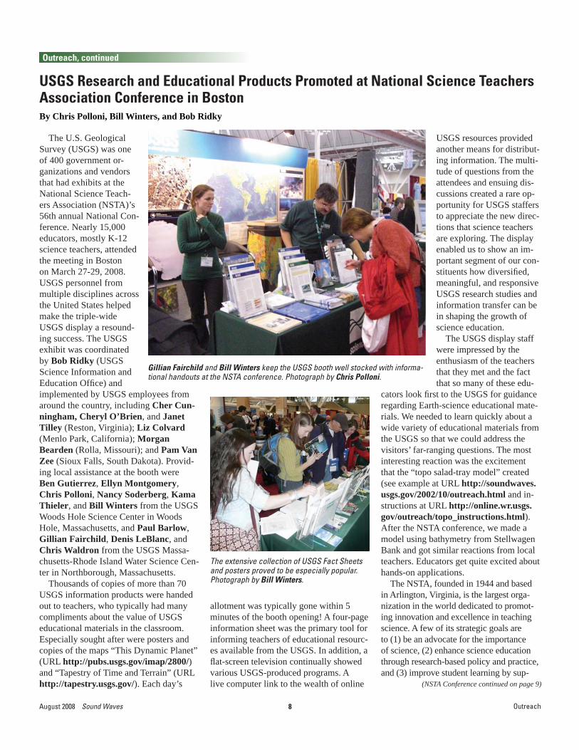
USGS Research and Educational Products Promoted at National Science Teachers Association Conference in BostonBy Chris Polloni, Bill Winters, and Bob Ridky
The U.S. Geological Survey (USGS) was one of 400 government or-ganizations and vendors that had exhibits at the National Science Teach-ers Association (NSTA)’s 56th annual National Con-ference. Nearly 15,000 educators, mostly K-12 science teachers, attended the meeting in Boston on March 27-29, 2008. USGS personnel from multiple disciplines across the United States helped make the triple-wide USGS display a resound-ing success. The USGS exhibit was coordinated by Bob Ridky (USGS Science Information and Education Offi ce) and
allotment was typically gone within 5 minutes of the booth opening! A four-page information sheet was the primary tool for informing teachers of educational resourc-es available from the USGS. In addition, a fl at-screen television continually showed various USGS-produced programs. A live computer link to the wealth of online
USGS resources provided another means for distribut-ing information. The multi-tude of questions from the attendees and ensuing dis-cussions created a rare op-portunity for USGS staffers to appreciate the new direc-tions that science teachers are exploring. The display enabled us to show an im-portant segment of our con-stituents how diversifi ed, meaningful, and responsive USGS research studies and information transfer can be in shaping the growth of science education.
The USGS display staff were impressed by the enthusiasm of the teachers that they met and the fact that so many of these edu-
Gillian Fairchild and Bill Winters keep the USGS booth well stocked with informa-tional handouts at the NSTA conference. Photograph by Chris Polloni.
implemented by USGS employees from around the country, including Cher Cun-ningham, Cheryl O’Brien, and Janet Tilley (Reston, Virginia); Liz Colvard (Menlo Park, California); Morgan Bearden (Rolla, Missouri); and Pam Van Zee (Sioux Falls, South Dakota). Provid-ing local assistance at the booth were Ben Gutierrez, Ellyn Montgomery, Chris Polloni, Nancy Soderberg, Kama Thieler, and Bill Winters from the USGS Woods Hole Science Center in Woods Hole, Massachusetts, and Paul Barlow, Gillian Fairchild, Denis LeBlanc, and Chris Waldron from the USGS Massa-chusetts-Rhode Island Water Science Cen-ter in Northborough, Massachusetts.
Thousands of copies of more than 70 USGS information products were handed out to teachers, who typically had many compliments about the value of USGS educational materials in the classroom. Especially sought after were posters and copies of the maps “This Dynamic Planet” (URL http://pubs.usgs.gov/imap/2800/) and “Tapestry of Time and Terrain” (URL http://tapestry.usgs.gov/). Each day’s
cators look fi rst to the USGS for guidance regarding Earth-science educational mate-rials. We needed to learn quickly about a wide variety of educational materials from the USGS so that we could address the visitors’ far-ranging questions. The most interesting reaction was the excitement that the “topo salad-tray model” created (see example at URL http://soundwaves.usgs.gov/2002/10/outreach.html and in-structions at URL http://online.wr.usgs.gov/outreach/topo_instructions.html). After the NSTA conference, we made a model using bathymetry from Stellwagen Bank and got similar reactions from local teachers. Educators get quite excited about hands-on applications.
The NSTA, founded in 1944 and based in Arlington, Virginia, is the largest orga-nization in the world dedicated to promot-ing innovation and excellence in teaching science. A few of its strategic goals are to (1) be an advocate for the importance of science, (2) enhance science education through research-based policy and practice, and (3) improve student learning by sup-
The extensive collection of USGS Fact Sheets and posters proved to be especially popular. Photograph by Bill Winters.

9 Sound Waves August 2008Outreach, Meetings
Outreach, continued
(American Geographers continued on page 10)
(NSTA Conference continued from page 8)
porting and enhancing science teaching. Science teachers and supervisors, adminis-trators, and scientists are among the organi-zation’s membership of more than 55,000.
Currently, the NSTA is conducting a “Building a Presence for Science” pro-gram that seeks eventually to have a point of contact in every public and private school in the United States. Such an enor-mous undertaking highlights the scope and importance of the NSTA in creating a dynamic national electronic network with which Federal and State agencies and other organizations can share information with science teachers.
More information about this conference is contained in a short report from the USGS Science Information and Education Offi ce posted at URL http://education.usgs.gov/docs/NSTA2008RWR.pdf (2.1-MB PDF fi le).]
Denis LeBlanc answers questions about USGS science. Photograph by Bill Winters.
The outreach activity “How to Make a Topo Salad-Tray Model” proved to be extremely popular. See online instructions at URL http://online.wr.usgs.gov/outreach/topo_instructions.html. Photograph by Bill Winters.
Meetings
USGS Hosts Field Trip for Association of American Geographers Meeting By Chris Polloni and Brian Andrews
On Monday, April 16, the USGS sponsored a fi eld trip to its Woods Hole Science Center in Woods Hole, Massa-chusetts, with a full day of activities for
The Association of American Geographers (AAG) held its annual meeting in Boston during the week of April 15-19, 2008 (see URL http://www.aag.org/annualmeetings/2008/). The U.S. Geological Survey (USGS), a corporate sponsor of this event, had an extensive exhibit booth that included a large display featuring the latest Landsat imagery of the continental United States and a special tour of recently processed color orthoimagery of Boston provided by the Massachusetts Geographic Information System (MassGIS) offi ce. USGS scientist John Bratton assisted with booth confi guration and setup, and several members of his family were on hand to enjoy the event.
Several papers and oral presentations were given by scientists from the USGS Coastal and Marine Geology Program (CMGP), including Brian Andrews, Matt Arsenault, Ben Gutierrez, Fran Light-som, Herman Karl, and Elizabeth Pend-leton. Many additional CMGP scientists contributed as coauthors.
participants. The tour began with a presen-tation by center chief Bill Schwab, who gave an overview of research programs
Bratton family observing the streets of Boston spread across 15 liquid-crystal-display (LCD) screens in a tiled display navigated by Brian Davis of the USGS Earth Resources Observation and Science (EROS) Data Center, Sioux Falls, South Dakota. Photograph by Chris Polloni.

10August 2008 Sound Waves
(American Geographers continued from page 9)
Meetings
Meetings, continued
and facilities at the center. Elizabeth Pendleton and Ben Gutierrez teamed up to lead an interactive discussion of ongo-ing projects that address sea-level-rise issues, such as coastal vulnerability and shoreline-change hazards. The fi eld trip included lunch in the village of Woods Hole, with a stop at Nobska Light before returning to the Woods Hole Science Cen-ter. After lunch, Brian Andrews, the resi-dent geographer, provided an overview of a cooperative mapping program between the USGS Woods Hole Science Center and the Massachusetts Offi ce of Coastal Zone Management. Chris Polloni demonstrated the center’s GeoWall—a stereo projection system for visualizing Earth features—giving participants virtual tours of Mas-sachusetts Bay, Boston Harbor, and the Puerto Rico Trench. Brian Buczkowski capped off the fi eld-trip activities with a tour of the K.O. Emery core-storage facil-ity, where he explained how samples are used to ground-truth mapping data, then catalogued and stored in this new state-of-the-art facility.]
Matt Arsenault explaining usSEABED to a con-ference participant during a poster session.
USGS Woods Hole Science Center director Bill Schwab addressing fi eld-trip participants in the center’s Tilley Conference Room.
Field-trip participants at Nobska Point.
No tour would be complete without a group photograph—in the background is a ferry passing Naushon Island off Woods Hole.
11 Sound Waves August 2008
Meetings, continued
Meetings
(Modeling Conference continued on page 12)
Report from the 2nd USGS Modeling Conference, February 10-14, 2008, in Orange Beach, AlabamaBy Heather Henkel and Chris Polloni
The 2nd U.S. Geological Survey (USGS) Modeling Conference was held February 10-14, 2008, in Orange Beach, Alabama. Sponsored by the USGS, this multidisciplinary conference built upon the success of the fi rst conference, held in 2005 at the Olympic Park Institute in Port Angeles, Washington (see URL http://pubs.usgs.gov/sir/2006/5308/). Whereas the fi rst conference focused on under-standing the current status of modeling within the USGS, the second conference focused on interagency collaboration and brought together scientists and managers from both within and beyond the USGS. The intent was to foster collaboration and encourage participants to share informa-tion in the hope that this cooperation would result in both short- and long-term enhancements of USGS modeling capa-bilities and science. The conference also provided a showcase for participants to display their modeling capabilities.
This year’s meeting was built around four themes: Integrated Landscape Moni-toring/Modeling, Global Change, Ecosys-tem Modeling, and Hazards and Risks. More than 160 attendees participated in this year’s event, which began on a Mon-day with free workshops: “An Introduc-tion to Structural Equation Modeling,” “MapWindow GIS—Integrating Modeling into a Customizable, Open-Source GIS,” and “An Introduction to Using PEST—a Model Independent Parameter Estimation and Uncertainty Analysis Code.”
Chris Polloni of the USGS Woods Hole Science Center (Woods Hole, Mas-sachusetts) attended the training session on MapWindow GIS, an open-source, programmable geographic-information system (GIS) that supports manipulation, analysis, and viewing of geospatial data and associated attribute data in several standard GIS formats. The 4-hour intro-duction and overview showed participants how to build a customized GIS tailored to a user’s data and intended use. Each attendee received a demo CD, a newly released guide, and a T-shirt! Polloni had
seen MapWindow GIS used at Woods Hole Oceanographic Institution. The software is useful but does require some knowledge of the C or C# programming languages.
The second day of the conference started off with USGS Chief Scientist for Geology Linda Gunderson (Reston, Virginia) and USGS Central Regional Director Thomas Casadevall (Denver, Colorado) welcoming the attendees to the conference. During her opening remarks, Gunderson discussed the need for more powerful computers (“big iron”) to sup-port the robustness of our modeling com-
munity. She also urged us to use the new USGS Science Strategy, as set forth in “Facing Tomorrow’s Challenges—U.S. Geological Survey Science in the Decade 2007–2017” (USGS Circular 1309, URL http://pubs.usgs.gov/circ/2007/1309/), to guide our efforts in interdisciplinary sci-ence, data integration, creating decision-support tools, and modeling scenarios. Gunderson’s address was followed by a day full of oral presentations and panel sessions on the fi rst two conference themes: Integrated Landscape Monitor-ing/Modeling and Global Change. The afternoon saw the audience participating in a town-hall-style meeting titled “Global Climate Change: Modeler’s Input.” The day ended with a poster session on the topics presented during the earlier oral presentations.
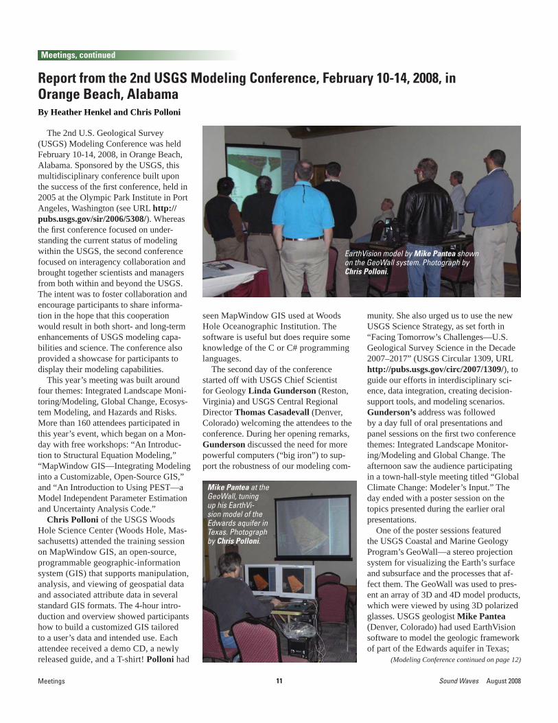
One of the poster sessions featured the USGS Coastal and Marine Geology Program’s GeoWall—a stereo projection system for visualizing the Earth’s surface and subsurface and the processes that af-fect them. The GeoWall was used to pres-ent an array of 3D and 4D model products, which were viewed by using 3D polarized glasses. USGS geologist Mike Pantea (Denver, Colorado) had used EarthVision software to model the geologic framework of part of the Edwards aquifer in Texas;
EarthVision model by Mike Pantea shown on the GeoWall system. Photograph by Chris Polloni.
Mike Pantea at the GeoWall, tuning up his EarthVi-sion model of the Edwards aquifer in Texas. Photograph by Chris Polloni.

12August 2008 Sound Waves
Meetings, continued
(Modeling Conference continued from page 11)
Meetings
he demonstrated additional usefulness of the modeling tool by showing water-level change over time. Several USGS DVD information products were provided as examples of how to publish interactive models. A “virtual” Brian Davis (USGS Earth Resources Observation and Sci-ence (EROS) Data Center) was present by recorded voice synced with an animated ArcScene model of a forest fi re spreading through various habitats and terrain. Con-sultant Mike Kelly’s educational model of Sunset Crater near Flagstaff, Arizona, was shown by Polloni, who provided instruc-tion on using remote-control devices (such as the Rumblepad and ROMA) to navigate the scene. A submarine fl ythrough of the Puerto Rico Trench included views of sub-sea-fl oor earthquake hypocenters to indicate the orientation of the subduction-zone fault. Two computers were used to run the GeoWall system: a Linux system confi gured by Dave Foster of the Woods Hole Science Center for use with EarthVi-sion, and a Windows XP Shuttle to support everything else. Dynamic Graphics, Inc., provided an EarthVision temporary license for use at the conference.
Heather Henkel of the USGS Florida Integrated Science Center offi ce in St. Petersburg and Leonard Pearlstine of Everglades National Park presented a poster titled “Spatially Continuous Inter-polation of Water Stage and Water Depths
Using the Everglades Depth Estima-tion Network (EDEN).” EDEN is an integrated network of real-time water-level monitoring, ground-elevation modeling, and water-surface modeling that provides scientists and managers with current (1999 to present), online water-depth information for the entire freshwater portion of the Greater Ev-erglades. Data and tools available at the EDEN Web site (URL http://sofi a.usgs.gov/eden/) enable investigators to calculate water depth and infer other hydrologic characteristics—such as recession rates, time since last dry period, and water-surface slope—vir-tually anywhere in the Everglades,
GeoWall display of the forest-fi re model created by Brian Davis. Photograph by Chris Polloni.
including sites diffi cult to visit in the fi eld. EDEN is funded by the Comprehensive Everglades Restoration Plan (CERP) and the USGS Priority Ecosystem Sciences (PES), with collaborative support from Federal and State Government agencies, scientists in South Florida, and the Univer-sity of Florida.
On Wednesday, many attendees en-joyed a vigorous fi eld trip to Mississippi Sandhill Crane National Wildlife Refuge, Grand Bay, 5 Rivers (Alabama’s Delta Resource Center), and Bon Secour Na-tional Wildlife Refuge. Some participants remained behind to participate in ad hoc working groups. That evening, a second poster session was devoted to the last two themes: Ecosystem Modeling, and Haz-ards and Risks. The fi nal day featured oral presentations and panel discussions on these two themes and closed with remarks by Linda Gunderson.]
The fi eld-trip group hiking in Missis-sippi Sandhill Crane National Wildlife Refuge. Photograph by Chris Polloni.
Heather Henkel explaining the Everglades Depth Estimation Network (EDEN) for model-ing water stage and depths in the Greater Everglades. Photograph by Chris Polloni.

13 Sound Waves August 2008
Publications
Publications
(Recently Published continued on page 14)
Poster of Sea Floor in Northern Monterey Bay, California, Depicts Complex Bathymetry, Including Bedrock Ridges that Cause Surf Breaks
The U.S. Geological Survey (USGS), along with the California Department of Boating and Waterways, the Santa Cruz County Redevelopment Agency, and the Santa Cruz Department of Public Works, has produced a poster displaying color-coded bathymetry, underwater photo-graphs, and oblique views of the sea fl oor in northern Monterey Bay off the coast of Santa Cruz, California.
“Views of the Sea Floor in Northern Monterey Bay, California” (USGS Sci-entifi c Investigations Map 3007) is an outgrowth of a sonar survey by the USGS in 2005 and 2006 that produced unprec-edented high-resolution images of the sea fl oor off Santa Cruz. Performed over 14 days, the survey consisted of 172 track-lines and more than 300 million soundings and covered an area of 12.2 km2 (4.7 mi2). The goals of the survey were to collect high-resolution bathymetry (depth to the sea fl oor) and acoustic-backscatter data (amount of sound energy bounced back from the sea fl oor, which provides infor-mation on sea-fl oor hardness and texture) from the inner continental shelf. These data will provide a baseline for future change analyses, geologic mapping, sedi-ment- and contaminant-transport studies, benthic-habitat delineation, and numerical-modeling efforts. The survey shows that the inner shelf in this area is extremely varied, encompassing fl at sandy areas,
N.E. and Finlayson, D.P., 2008, Views of the sea fl oor in northern Monterey Bay, California: USGS Scientifi c Investigations Map 3007 [URL http://pubs.usgs.gov/sim/3007/]. Paper copies can be obtained from the USGS Science Information and Library Services (SILS) at 1-888-ASK-USGS, or the USGS online store at URL http://store.usgs.gov/ (product number 208389). The poster can be downloaded as a Portable Document Format (PDF) fi le at URL http://pubs.usgs.gov/sim/3007/.]
Excerpt from “Views of the Sea Floor in Northern Monterey Bay, California” (USGS Scientifi c In-vestigations Map 3007), with index map superimposed. Labels of sea-fl oor features that cause surf breaks (for example, “Steamer Lane”) have been darkened for greater visibility at reduced scale.
MIT
CHEL
LS
STEA
MER
LAN
E
SABE
RJE
TS
INDI
CATO
RS
COW
ELLS
RIVER
MOUTH
fault traces, boulder fi elds, and complex bedrock ridges that support rich marine ecosystems. Furthermore, many of these complex bedrock ridges form the “reefs” that result in a number of California’s clas-sic surf breaks.
The new poster, which measures 46 by 36 inches, features map and oblique views of the bathymetric data collected during the survey, plus underwater photographs from selected sites. The full reference for the poster is: Storlazzi, C.D., Golden,
to analyze and predict dynamics of mangrove forests; a review: Aquatic Botany, v. 89, no. 2, p. 260-274, doi:10.1016/j.aquabot.2007.12.015 [URL http://dx.doi.org/10.1016/j.aquabot.2007.12.015].
Birkeland, Charles, Craig, Peter, Fenner, Douglas, Smith, Lance, Kiene, W.E., and Riegl, B.M., 2008, Geologic setting and ecological functioning of coral reefs in American Samoa, in Riegl, B., and Dodge, R., eds., Coral reefs of the USA, v. 1 of Coral reefs of the world: Berlin,
Springer Science+Business Media, p. 741-766 [URL http://www.springer.com/earth+sciences/book/978-1-4020-6846-1].
Brame, A.B., Krebs, J.M., and McIvor, C.C., 2005, Wetland habitat use by the nekton community at Weedon Island County Preserve and Feather Sound; summary of 2004 data: Tampa Bay Study Digital Library Results, 27 p. [URL http://dl.cr.usgs.gov/tampa/prod_search_tampa.aspx?prodid=21415].
Anima, R.L., Chin, J.L., Finlayson, D.P., McGann, M.L., and Wong, F.L., 2008, Interferometric sidescan mapping, sediment and foraminiferal analyses; a new look at Tomales Bay, California: USGS Open-File Report 2008-1237 [URL http://pubs.usgs.gov/of/2008/1237/].
Berger, U., Rivera-Monroy, V.H., Doyle, T.W., Dahdouh-Guebas, F., Duke, N.C., Fontalvo-Herazo, M.L., Hildenbrandt, H., Koedam, N., Mehlig, U., Piou, C., and Twilley, R.R., 2008, Advances and limitations of individual-based models
Recently Published Articles

14August 2008 Sound Waves
Publications, continued
(Recently Published continued from page 13)
Publications
(Recently Published continued on page 15)
Brame, A.B., and McIvor, C.C., 2007, A holistic approach to determining juvenile snook habitat use in a Tampa Bay tidal wetland: Estuarine Research Federation Conference, Providence, R.I., November 4-8, 2007, abstracts, p. 18 [URL http://www.erf.org/cgi-bin/conference07_abstract.pl?conference=erf2007&hilite=Brame&id=100].
Butman, B., Sherwood, C.R., and Dalyander, P.S., 2008, Northeast storms ranked by wind stress and wave-generated bottom stress observed in Massachusetts Bay, 1990-2006: Continental Shelf Research, v. 28, no. 10-11, p. 1231-1245, doi:10.1016/j.csr.2008.02.010 [URL http://dx.doi.org/10.1016/j.csr.2008.02.010].
Carnahan, E.A., Hoare, A.M., Hallock, P., Lidz, B.H., and Reich, C.D., 2008, Distribution of heavy metals and foraminiferal assemblages in sediments in Biscayne Bay, Florida, USA: Journal of Coastal Research, v. 24, no. 1, p. 159-169, doi: 10.2112/06-0666.1 [URL http://dx.doi.org/10.2112/06-0666.1].
Cross, V.A., Bratton, J.F., Crusius, John, Colman, J.A., and McCobb, T.D., Submarine hydrogeological data from Cape Cod National Seashore: U.S. Geological Survey Open-File Report 2006-1169 [URL http://woodshole.er.usgs.gov/pubs/of2006-1169/].
Dreher, C.A., Flocks, J.G., Ferina, N., Kulp, M.A., and Calderon, K., 2008, Archive of sediment-vibracore data collected from Sandy Point to Belle Pass, Louisiana, 1983 through 2000 (vibracore surveys: 00SCC, 83CR, and P86, and USACE borehole cores): U.S. Geological Survey Data Series DS-344 [URL http://pubs.usgs.gov/ds/344/].
Elsey-Quirk, T., Middleton, B.A., and Proffi tt, C.E., 2008, Seed dispersal and seedling emergence in a created and a natural salt marsh on the Gulf of Mexico coast in southwest Louisiana, U.S.A.: Restoration Ecology, Early View, 11 p., doi:10.1111/j.1526-100X.2008.00398.x [URL http://www3.interscience.wiley.com/journal/120124297/abstract].
Fletcher, C.H., Bochicchio, Chris, Conger, C.L., Engels, M.S., Feirstein, E.J., Frazer, Neil, Glenn, C.R., Grigg, R.W., Grossman, E.E., Harney, J.N., Isoun, Ebitari, Murray-
Wallace, C.V., Rooney, J.J., Rubin, K.H., Sherman, C.E., and Vitousek, Sean, 2008, Geology of Hawaii reefs, in Riegl, B., and Dodge, R., eds., Coral reefs of the USA, v. 1 of Coral reefs of the world: Berlin, Springer Science+Business Media, p. 435-488 [URL http://www.springer.com/earth+sciences/book/978-1-4020-6846-1].
Hein, J.R., Schulz, M.S., Dunham, R.E., Stern, R.J., and Bloomer, S.H., 2008, Diffuse fl ow hydrothermal manganese mineralization along the active Mariana and southern Izu-Bonin arc system, western Pacifi c: Journal of Geophysical Research, v. 113, B08S14, doi:10.1029/2007JB005432 [URL http://dx.doi.org/10.1029/2007JB005432].
Hine, A.C., Halley, R.B., Locker, S.D., Jarrett, B.D., Jaap, W.C., Mallinson, D.J., Ciembronowicz, K.T., Ogden, N.B., Donahue, B.T., and Naar, D.F., 2008, Coral reefs, present and past, on the west Florida shelf and platform margin, in Riegl, B., and Dodge, R., eds., Coral reefs of the USA, v. 1 of Coral reefs of the world: New York, Springer Science+Business Media, p. 127-173 [URL http://www.springer.com/earth+sciences/book/978-1-4020-6846-1].
Krauss, K.W., Lovelock, C.E., McKee, K.L., López-Hoffman, L., Ewe, S.M.L., and Sousa, W.P., 2008, Environmental drivers in mangrove establishment and early development; a review: Aquatic Botany, no. 2, p. 105-127, doi:10.1016/j.aquabot.2007.12.014 [URL http://dx.doi.org/10.1016/j.aquabot.2007.12.014].
Krebs, J.M., Brame, A.B., and McIvor, C.C., 2005, Wetland habitat use by the nekton community at Terra Ceia State Aquatic Buffer Preserve; summary of 2004 data: Tampa Bay Study Digital Library Results, 31 p. [URL http://dl.cr.usgs.gov/tampa/prod_search_tampa.aspx?prodid=21416].
Krebs, J.M., McIvor, C.C., and Bell, S.S, 2007, Assessing restoration success using nekton-based metrics of habitat quality in a tidal mangrove wetland [abs.]: Research Federation Conference, Providence, R.I., November 4-8, 2007, abstracts, p. 115 [URL http://www.erf.org/cgi-bin/
conference07_abstract.pl?conference=erf2007&hilite=krebs&id=615].
Kroeger, K.D., and Charette, M.A., 2008, Nitrogen biogeochemistry of submarine groundwater discharge: Limnology and Oceanography, v. 53, no. 3, p. 1025-1039 [URL http://www.aslo.org/lo/toc/vol_53/issue_3/].
Lidz, B.H., Shinn, E.A., Hudson, J.H., Multer, H.G., Halley, R.B., and Robbin, D.M., 2008, Controls on late Quaternary coral reefs of the Florida Keys, in Riegl, B., and Dodge, R., eds., Coral reefs of the USA, v. 1 of Coral reefs of the world: Berlin, Springer Science+Business Media, p. 9-74 [URLhttp://www.springer.com/earth+sciences/book/978-1-4020-6846-1].
Miller, M.W., Halley, R.B., and Gleason, A.C.R., 2008, Reef geology and biology of Navassa Island, in Riegl, B., and Dodge, R., eds., Coral reefs of the USA, v. 1 of Coral reefs of the world: Berlin, Springer Science+Business Media, p. 407-433 [URL http://www.springer.com/earth+sciences/book/978-1-4020-6846-1].
Osterman, L.E., Poore, R.Z., and Swarzenski, P.W., 2008, 1000 years of recurring natural and anthropogenic low-oxygen water on the Louisiana shelf, Gulf of Mexico [abs.]: “From the Watershed to the Global Ocean,” Ocean Sciences Meeting, Orlando, Fla., March 2-7, 2008, abstracts, p. 342 [URL http://www.sgmeet.com/aslo/orlando2008/viewabstract2.asp?AbstractID=46].
Palaseanu-Lovejoy, M., Nayegandhi, A., Brock, J., Woodman, R., and Wright, C.W., 2008, Evaluation of airborne light detection and ranging (lidar) data to classify and predict vegetation communities [abs.], in Helterbrand, W.S., and Sieverling, J.B., eds., Proceedings of the U.S. Geological Survey Seventh Biennial Geographic Information Science Workshop, Denver, Colorado, May 12–16, 2008: U.S. Geological Survey Scientifi c Investigations Report 2008-5074, p. 46 [URL http://pubs.usgs.gov/sir/2008/5074/].
Parsons, Tom; Chen Ji; and Kirby, Eric, 2008, Stress changes from the 2008

15 Sound Waves August 2008
Publications, continued
Publications
(Recently Published continued from page 14)
(Publications Submitted continued on page 16)
Wenchuan earthquake and increased hazard in the Sichuan basin: Nature, v. 454, no. 7203, p. 509-510, doi:10.1038/nature07177 [URL http://dx.doi.org/10.1038/nature07177].
Poore, R.Z., and Richey, J.N., 2008, Northern Gulf of Mexico climate variability [abs.]: “From the Watershed to the Global Ocean,” Ocean Sciences Meeting, Orlando, Fla., March 2-7, 2008, abstracts, p. 363 [URL http://www.sgmeet.com/aslo/orlando2008/viewabstract2.asp?AbstractID=50].
Poppe, L.J., McMullen, K.Y., Foster, D.S., Blackwood, D.S., Williams, S.J., Ackerman, S.D., Barnum, S.R., and Brennan, R.T., 2008, Sea-fl oor character and sedimentary processes in the vicinity of Woods Hole, Massachusetts: U.S. Geological Survey Open-File Report 2008-1004 [URL http://woodshole.er.usgs.gov/pubs/of2008-1004/].
Raabe, E.A., and Bialkowska-Jelinska, E., 2008, Thermal infrared mapping of coastal-aquifer seeps and associations between seeps and coastal habitats [abs.], in Kuniansky, E.L., ed., U.S. Geological Survey Karst Interest Group Proceedings, Bowling Green, Kentucky, May 27-29, 2008: U.S. Geological Survey Scientifi c Investigations Report 2008-5023, p. 58-60 [URL http://pubs.usgs.gov/sir/2008/5023/].
Raabe, E.A., Harris, M.S., Shrestha, R.L., and Carter, W.E., 2008, Laser-derived
ground surface, plant canopy, and geomorphology of a Florida coastal wetland [abs.], in Helterbrand, W.S., and Sieverling, J.B., eds., Proceedings of the U.S. Geological Survey Seventh Biennial Geographic Information Science Workshop, Denver, Colorado, May 12–16, 2008: U.S. Geological Survey Scientifi c Investigations Report 2008-5074, p. 46-47 [URL http://pubs.usgs.gov/sir/2008/5074/].
Robbins, Lisa, Wolfe, Steven, and Raabe, Ellen, 2008, Mapping of Florida’s Coastal and Marine Resources; Setting Priorities Workshop: U.S. Geological Survey Open-File Report 2008-1157, 41 p. [URL http://pubs.usgs.gov/of/2008/1157/].
Rogers, C., Miller, J., Muller, E., Edmunds, P., Nemeth, R., Beets, J., Friedlander, A., Smith, T., Boulon, R., Jeffrey, C., Menza, C., Caldow, C., Idrisi, N., Kojis, B., Monaco, M., Spitzack, T., Gladfelter, B., Ogden, J., Hillis-Starr, Z., Lundgren, I., Schill, W.B., Kuffner, I., Richardson, L., Devine, B., and Voss, J., 2008, Ecology of coral reefs in the US Virgin Islands, in Riegl, B., and Dodge, R., eds., Coral reefs of the USA, v. 1 of Coral reefs of the world: Berlin, Springer Science+Business Media, p. 303-373 [URL http://www.springer.com/earth+sciences/book/978-1-4020-6846-1].
Storlazzi, C.D., and Field, M.E., 2008, Winds, waves, tides, and the resulting
fl ow patterns and fl uxes of water, sediment, and coral larvae off West Maui, Hawaii: USGS Open-File Report 2008-1215, 13 p. [URL http://pubs.usgs.gov/of/2008/1215/].
Sullivan, C.M., Subino, J., Morgan, K., Krohn, M.D., Dadisman, S.V., and Sallenger, A.H., Jr., 2007, XSTORMS; a processing, archival, and dissemination tool for extreme storm event data [abs.]: Geological Society of America Abstracts with Programs, v. 39, no. 6, p. 211 [URL http://gsa.confex.com/gsa/2007AM/fi nalprogram/abstract_130281.htm].
Warner, J.C., Perlin, N., and Skyllingstad, E.D., 2008, Using the Model Coupling Toolkit to couple earth system models: Environmental Modeling and Software, v. 23, no. 10-11, p. 1240-1249, doi:10.1016/j.envsoft.2008.03.002 [URL http://dx.doi.org/10.1016/j.envsoft.2008.03.002].
Warrick, J.A., Cochrane, G.R., Sagy, Y., and Gelfenbaum, G., 2008, Nearshore substrate and morphology offshore of the Elwha River: Northwest Science, v. 82 (special issue), p. 153-163 [URL http://www.pc.ctc.edu/coe/publications.htm].
Warrick, J.A., George, D.A., Stevens, A.W., Eshleman, Jodi, Gelfenbaum, Guy, Kaminsky, G.M., Schwartz, A.K., and Bierne, Matt, 2007, Beach morphology monitoring in the Elwha River littoral cell, 2004-2006: U.S. Geological Survey Data Series 288, 38 p. [URL http://pubs.usgs.gov/ds/288/].]
Bernier, J.C., and Morton, R.A., Recent reductions of subsidence rates in the Mississippi River Delta plain [abs.]: Geological Society of America Annual Meeting, Houston, Tex., October 5-9, 2008.
Bonisteel, J.M., Nayegandhi, A., and Brock, J.C., Utilizing lidar-derived digital-elevation models to evaluate morphologic change [abs.]: National Lidar Meeting, 2nd, Reston, Va., May 21-22, 2008.
Dartnell, Peter, Collier, Robert, Buktenica, Mark, Jessup, Steven, Girdner, Scott, and Triezenberg, Peter, Multibeam sonar mapping and modeling of a submerged
bryophyte mat in Crater Lake, OR: U.S. Geological Survey Data Series.
Galkiewicz, J.P., and Kellogg, C.A., Cross-Kingdom amplifi cation using bacterial-specifi c primers; complications for coral microbial ecology: Applied and Environmental Microbiology.
Kellogg, C.A., Microbiology of deep-sea corals [abs.]: USGS Interdisciplinary Microbiology Workshop, Estes Park, Colo., October 15-17, 2008.
Knorr, P.O., Robbins, L.L., and Harries, P.J., Effects of increased pCO2 on aragonite crystal morphology in Halimeda spp. [abs.]: Geological Society of America
Annual Meeting, Houston, Tex., October 5-9, 2008.
Krohn, M.D., Morgan, K.L.M., Peterson, R., Sullivan, C.M., and Sallenger, A.H., Response and recovery of barrier-island beaches documented by the USGS Extreme Storms Program [abs.]: Geological Society of America Annual Meeting, Houston, Tex., October 5-9, 2008.
Morton, R.A., Historical changes in the Mississippi-Alabama barrier-island chain and the roles of extreme storms, sea level, and human activities: Journal of Coastal Research.
Publications Submitted for Bureau Approval

16August 2008 Sound Waves
Publications, continued
(Publications Submitted continued from page 15)
Publications
Morton, R.A., Bernier, J.C., and Barras, J.A., Historical subsidence and wetland loss in the Mississippi Delta plain and the role of hydrocarbon production [abs.]: Geological Society of America Annual Meeting, Houston, Tex., October 5-9, 2008.
Nayegandhi, A., Palaseanu-Lovejoy, M., Brock, J.C., Wright, C.W., and Woodman, R., Determining vegetation structure using small-footprint, waveform-resolving lidar [abs.]: National Lidar Meeting, 2nd, Reston, Va., May 21-22, 2008.
Normark, W.R., Paull, C.K., Caress, D.W., Ussler, William, III, and Sliter, Ray, Fine-scale relief related to late Holocene channel shifting within the fl oor of upper Redondo fan valley in San Pedro basin, offshore southern California: Marine Geology.
Piper, D.J.W., and Normark, W.R., Initiating processes and turbidity currents; a marine geology perspective: Journal of Sedimentary Research.
Raabe, E., and Pope, D., Climate change and coastal wetlands; patterns of long- and short-term change on Florida’s Gulf Coast [abs.]: Wildlife Society Annual Conference, 15th, Miami, Fla., November 8-12, 2008.
Robbins, L.L., Knorr, P., Hallock, P., and Yates, K.K., Comparison of Halimeda aragonite from 40 years of archived fi eld
samples with specimens grown in high pCO2 seawater [abs.]: Symposium on the Ocean in a High-CO2 World, 2nd, Monaco, October 6-9, 2008.
Ross, S.L., Conrad, J.E., Ryan, H.R., Chin, J.L., Dartnell, Peter, Edwards, B.D., Phillips, E.L., Sliter R.W., and Wong, F.L., Detailed geophysical observations of a double-stranded fault; structure and behavior [abs.]: “New Challenges in Earthquake Dynamics: Observing and Modelling a Multi-Scale System,” European Science Foundation Research Conference, Obergurgl, Austria, October 18-23, 2008.
Storlazzi, C.D., Presto, M.K., Logan, J.B., and Field, M.E., Coastal circulation and sediment dynamics in Hanalei Bay, Kauai; part IV—measurements of waves, currents, temperature, salinity, and turbidity; June-August 2006: U.S. Geological Survey Open-File Report.
Tedesco, K.A., Poore, R.Z., Thunell, R.C., and Tappa, E.J., Calibration of Holocene paleoenvironmental proxy records from the northern Gulf of Mexico [abs.]: Geological Society of America Annual Meeting, Houston, Tex., October 5-9, 2008.
Tedesco, K.A., Tappa, E.J., Thunell, R.C., and Poore, R.Z., Holocene
paleoenvironmental proxy record calibration for the northern Gulf of Mexico [abs.]: Florida Integrated Science Center Meeting, Orlando, Fla., October 22-23, 2008.
van der Wegen, Mick, Roelvink, Dano, Jaffe, Bruce, Ganju, Neil, and Schoellhamer, Dave, Hindcasting bathymetric change in San Pablo Bay, 1856-1983; a step towards assessing likely geomorphic change in response to climate change [abs.]: CALFED Biennial Science Conference, 5th, Sacramento, Calif., October 22-24, 2008.
Warrick, J.A., and Mertes, L.A., Sediment production from the tectonically active semi-arid Western Transverse Ranges of California: Geological Society of America Bulletin.
Yates, K., Dufore, C., and Smiley, N., In-situ measurements of calcifi cation rates and calcifi cation/dissolution thresholds in coral reef communities of South Florida and the U.S. Virgin Islands [abs.]: International Coral Reef Symposium, 11th, Fort Lauderdale, Fla., July 7-11, 2008.
Zawada, D.G., and Brock, J.C., A multiscale analysis of coral reef topographic complexity using lidar-derived submerged topography: Journal of Coastal Research.]


![COASTAL TRAPPED DIURNAL TIDAL WAVES OBSERVED ALONG … · Simulated currents (from Nakamura et al. [2000]) Observations of diurnal continental shelf waves and coastal trapped waves](https://img.pdfslide.net/doc/110x75/60e3028012bd9820fb6f12bc/coastal-trapped-diurnal-tidal-waves-observed-along-simulated-currents-from-nakamura.jpg)