Embed Size (px)
Citation preview
Source Water Protection Plan for the
Upper South Platte River CO0116001
Surface Water Sources
Park, Douglas, Jefferson, and Teller Counties, Colorado
Denver Water
1600 W. 12th Ave. Denver, CO 80204
Prepared in Collaboration with the
Coalition for the Upper South Platte
November 2015
Never doubt that a small group of thoughtful, committed citizens can change the world; indeed, it’s the only thing that ever does.
– Margaret Mead
When the well is dry, we know the worth of water
– Benjamin Franklin
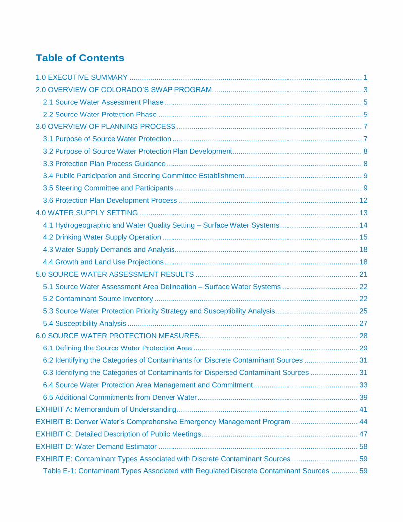
Table of Contents 1.0 EXECUTIVE SUMMARY ................................................................................................................. 1
2.0 OVERVIEW OF COLORADO’S SWAP PROGRAM ......................................................................... 3
2.1 Source Water Assessment Phase ................................................................................................ 5
2.2 Source Water Protection Phase ................................................................................................... 5
3.0 OVERVIEW OF PLANNING PROCESS .......................................................................................... 7
3.1 Purpose of Source Water Protection ............................................................................................ 7
3.2 Purpose of Source Water Protection Plan Development ............................................................... 8
3.3 Protection Plan Process Guidance ............................................................................................... 8
3.4 Public Participation and Steering Committee Establishment ......................................................... 9
3.5 Steering Committee and Participants ........................................................................................... 9
3.6 Protection Plan Development Process ....................................................................................... 12
4.0 WATER SUPPLY SETTING .......................................................................................................... 13
4.1 Hydrogeographic and Water Quality Setting – Surface Water Systems ...................................... 14
4.2 Drinking Water Supply Operation ............................................................................................... 15
4.3 Water Supply Demands and Analysis ......................................................................................... 18
4.4 Growth and Land Use Projections .............................................................................................. 18
5.0 SOURCE WATER ASSESSMENT RESULTS ............................................................................... 21
5.1 Source Water Assessment Area Delineation – Surface Water Systems ..................................... 22
5.2 Contaminant Source Inventory ................................................................................................... 22
5.3 Source Water Protection Priority Strategy and Susceptibility Analysis ........................................ 25
5.4 Susceptibility Analysis ................................................................................................................ 27
6.0 SOURCE WATER PROTECTION MEASURES ............................................................................. 28
6.1 Defining the Source Water Protection Area ................................................................................ 29
6.2 Identifying the Categories of Contaminants for Discrete Contaminant Sources .......................... 31
6.3 Identifying the Categories of Contaminants for Dispersed Contaminant Sources ....................... 31
6.4 Source Water Protection Area Management and Commitment ................................................... 33
6.5 Additional Commitments from Denver Water .............................................................................. 39
EXHIBIT A: Memorandum of Understanding ........................................................................................ 41
EXHIBIT B: Denver Water’s Comprehensive Emergency Management Program ................................ 44
EXHIBIT C: Detailed Description of Public Meetings ............................................................................ 47
EXHIBIT D: Water Demand Estimator ................................................................................................. 58
EXHIBIT E: Contaminant Types Associated with Discrete Contaminant Sources ................................ 59
Table E-1: Contaminant Types Associated with Regulated Discrete Contaminant Sources ............. 59

Table E-2: Contaminant Types Associated with Contaminant Types Associated With SIC-Related
Discrete Contaminant Sources ......................................................................................................... 60
EXHIBIT F: Potential Sources of Contamination .................................................................................. 67
EXHIBIT G: Contaminant Types Associated with Dispersed Contaminant Sources ............................. 79
EXHIBIT H: BMP Checklist .................................................................................................................. 81
EXHIBIT I: Acronym List .................................................................................................................... 110
1.0 EXECUTIVE SUMMARY
1
1.0 EXECUTIVE SUMMARY
Denver Water recognizes the importance of watershed health and source water protection and has been actively working in the Upper South Platte River watershed for more than a century. Denver Water chose to prepare its first formal Source Water Protection Plan (SWPP) for the Upper South Platte River (USPR) watershed. Denver Water chose the USPR watershed as a trial for future SWPPs on other watersheds in Denver Water’s supply system because it provides water to many residents of Colorado’s Front Range, including Denver Water’s 1.3 million customers. It is also the largest of Denver Water’s source water watersheds (2,600 square miles). Denver Water intends to use experience gained in the preparation of this plan to inform other source water protection planning efforts.
The potential financial and water supply risks of possible contamination of Denver Water’s water sources are a concern to water suppliers in the Upper South Platte River watershed and downstream cities reliant upon water from the Upper South Platte River. While the water quality analyses conducted by both the Colorado Department of Public Health and Environment (CDPHE) and Denver Water show the Upper South Platte River watershed has high quality water, there is a need to continually work to protect water quality. This SWPP was developed utilizing a Steering Committee and stakeholders from the watershed to prioritize source water protection concerns and to identify local source water management approaches that can be implemented to protect source water. The source water assessment results supplied by the CDPHE were used as a starting point in developing the SWPP.
The Steering Committee for this planning effort was created to reach a broad base of stakeholders in the watershed and consists of staff members from water suppliers including Denver Water and Aurora Water; CDPHE coordinators; staff from Park, Teller, Jefferson and Douglas counties; staff from federal agencies including the USFS, BLM and EPA; staff from the nonprofit Colorado Trout Unlimited; members of the Center of Colorado Water Conservancy District; a well-informed citizen of the Upper South Platte Watershed; and Coalition for the Upper South Platte staff. The Denver Water Upper South Platte River Source Water Protection Steering Committee (Steering Committee) recommended adopting a Source Water Protection Area (SWPA) that is similar to the source water assessment area defined by the CDPHE, only including the Upper South Platte River watershed. The source water protection area defines the region where the Steering Committee has chosen to implement its source water protection measures. The chosen source water protection measures attempt to reduce the susceptibility of their source water to potential contamination.
The Steering Committee adopted a two-step strategy recommended by the CDPHE for prioritizing the water sources and potential contaminant sources of focus for the protection measures. The first step of the strategy prioritized the water sources based on their total contaminant susceptibility and physical setting vulnerability scores. The second step prioritized the potential contaminant sources based on (1) their prevalence, (2) the potential threat they pose, or (3) a combination of prevalence and potential threat. Using this strategy, the Steering Committee recommended focusing source water protection measures on both the most prevalent and threatening discrete contaminant sources and the most prevalent dispersed contaminant sources in the source water protection area.
2
Voluntarily implementing source water management approaches provides an additional level of protection to the drinking water supply by taking preventive measures at the local level (i.e., county and municipal level) to protect the source water. The Steering Committee reviewed and discussed a number of source water management approaches that could be implemented within the source water protection area to help reduce the potential risks of contamination from the prioritized potential contaminant sources. The Steering Committee established acceptance criteria as part of identifying and selecting the most feasible source water management approaches to implement locally.
The Steering Committee recommended specific source water best management practices to be implemented by Denver Water, watershed partners, state and federal regulatory agencies, and local governments including the Park, Teller, Jefferson and Douglas county planning commissions. The topic areas the Steering Committee focused on are listed below:
Onsite Wastewater Treatment Systems (OWTS)
Agriculture Practices
Oil & Gas Exploration
Transportation: Roads and Maintenance
Transportation: Emergency Response and Hazardous Waste
Forest Health
Mine Drainage and Uranium Development
Hydro-Geomorphic Issues
Monitoring
GIS/Mapping
Outreach & Education Denver Water, the Coalition for the Upper South Platte (CUSP) and the Steering Committee will work to implement this plan in order to maintain high quality water and reduce the need for additional water treatment costs in the future. The Steering Committee estimates it will cost approximately $495,500 in time and materials to implement these management approaches. Funding to cover these costs will come from a broad base of funding sources and will consist primarily of in-kind donations of time and materials. Implementation of these management approaches began on June 30, 2015 and is ongoing.
Denver Water voluntarily commits to work with the counties within the Upper South Platte Watershed through a Memorandum of Understanding (MOU). Within this MOU (attached in Exhibit A), Denver Water commits to share resources including GIS spatial data on the delineated SWPA, share information on SWPP implementation and update the counties annually on progress. Additionally, Denver Water commits to develop SWPPs for other watersheds within their collection system. Specifically, Denver Water will create a SWPP for the Fraser River Watershed. Lastly, Denver Water commits to assist the CDPHE in refining their plans and mentoring other utilities creating SWPPs.
3
2.0 OVERVIEW OF
COLORADO’S SWAP PROGRAM
4
2.0 OVERVIEW OF COLORADO’S SWAP PROGRAM
Source water assessment and protection came into existence in 1996 as a result of Congressional reauthorization and amendment of the Safe Drinking Water Act. The 1996 amendments required each state to develop a Source Water Assessment and Protection (SWAP) program. The Water Quality Control Division (WQCD), an agency of the CDPHE, assumed the responsibility of developing Colorado’s SWAP program. The SWAP program protection plan is integrated with the existing Colorado Wellhead Protection Program that was established in amendments made to the federal Safe Drinking Water Act (SDWA, Section 1428) in 1986. Wellhead protection is a preventative concept that aims to protect public groundwater wells from contamination. The Wellhead Protection Program and the SWAP program have similar goals and combine protection efforts into one merged program plan.
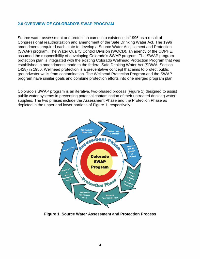
Colorado’s SWAP program is an iterative, two-phased process (Figure 1) designed to assist public water systems in preventing potential contamination of their untreated drinking water supplies. The two phases include the Assessment Phase and the Protection Phase as depicted in the upper and lower portions of Figure 1, respectively.
Figure 1. Source Water Assessment and Protection Process
5
2.1 Source Water Assessment Phase
As depicted in the upper portion of Figure 1, the Assessment Phase for all public water systems consists of four primary elements.
1. Delineating the source water assessment area for each drinking water source
2. Conducting a contaminant source inventory to identify potential sources of contamination within each of the source water assessment areas
3. Conducting a susceptibility analysis to determine the potential susceptibility of each public drinking water source to the different sources of contamination
4. Reporting the results of the source water assessment to the public water systems and the general public
The Assessment Phase involves understanding which potential contaminant sources threaten the Upper South Platte River Watershed and how close the water source is to specific potential contamination sources. The susceptibility of an individual water source is analyzed by examining the properties of its physical setting (e.g. proximity of potential contaminant sources to the water source) and potential contaminant source threats. The resulting analyses report an estimate of how susceptible each water source is to potential contamination.
2.2 Source Water Protection Phase
The Protection Phase is an ongoing process in which the Steering Committee has encouraged voluntary implementation of preventive measures to protect the water supply from the potential sources of contamination to which it is most susceptible. The Protection Phase aids in avoiding unnecessary treatment or replacement costs associated with potential contamination of the untreated water supply. Source water protection begins when local decision-makers use the source water assessment results, in addition to other pertinent information, as a starting point to develop a protection plan. As depicted in the lower portion of Figure 1, the source water protection phase for all public water systems consists of four primary elements.
1. Involving local stakeholders in the planning process
2. Developing a comprehensive protection plan for all of their drinking water sources
3. Implementing the protection plan on a continuous basis to reduce the risk of potential contamination of the drinking water sources
4. Monitoring the effectiveness of the protection plan and updating it accordingly as future assessment results indicate
The water system and the community recognize that the Safe Drinking Water Act grants no statutory authority to the Colorado Department of Public Health and Environment or to any other state or federal agency to force the adoption or implementation of source water protection measures. This authority rests solely with local communities and governments. The source water protection phase is an iterative process as indicated in Figure 1. The evolution of the SWAP program is to incorporate any new assessment information provided by the public water supply systems and update the protection plan
6
3.0 OVERVIEW OF
PLANNING PROCESS
7
3.0 OVERVIEW OF PLANNING PROCESS
3.1 Purpose of Source Water Protection
Denver Water’s existing water treatment plants are fed by watersheds with relatively high quality water; consequently, the probability of needing to add advanced treatment technologies to these plants in the 20-year budgeting period is considered to be low. However, should advanced treatment be needed, it will be expensive. Cost estimates range from $1 to $1.8 billion depending on the technology. Avoiding technology upgrades through Source Water Protection Planning is anticipated to cost much less. Source Water Protection Planning can also protect water supply health by proactive management of lands damaged by fire, acid mine drainage, energy extraction practices and land development regulations that ensure storm water quality and proper sanitation. For all of Denver Water’s watersheds, Denver Water has been working to improve water quality monitoring and evaluation, participate in watershed groups and lobby for increased protection of drinking water sources. In 2012, Denver Water selected the Upper South Platte River Watershed for its first preliminary water quality assessment and used it to develop a standard watershed evaluation approach that can be applied to the remaining watersheds. The watershed is more than 2,600 square miles and reaches from the Continental Divide to Strontia Springs Reservoir, southwest of Denver. It varies in elevation from about 6,000 feet to more than 14,000 feet above sea level and contains five major municipal and several smaller reservoirs. The watershed is geographically the largest of Denver Water’s source water watersheds and provides municipal water for approximately three quarters of Colorado’s residents. Additionally, it is a recreational mecca with more than 1.6 million acres of public lands, renowned for its “gold-medal” fishing streams and is home to numerous threatened and endangered species. Denver Water hired ARCADIS in December 2012 to evaluate the water quality data for the Upper South Platte River in close collaboration with Denver Water staff and Jim C. Loftis, Ph.D. Professor in the Civil and Environmental Engineering Department at Colorado State University. The results from the water quality assessment demonstrated that the Upper South Platte Watershed is generally in good health and that water quality has been stable or improving over the last 10 years. Denver Water’s formal Upper South Platte Watershed Source Water Protection Planning process was initiated in 2013. The plan was developed as part of a collaborative process convened by Denver Water, facilitated by the Coalition for the Upper South Platte (CUSP, and funded by the CDPHE through the Colorado Source Water Assessment and Protection program. The planning process and final plan are designed to provide municipal water providers and public consumers with information about drinking water, as well as provide a way for water providers and community members to get involved in protecting the quality of their drinking water. The program encourages community-based protection and preventive management strategies to ensure public drinking water resources are kept safe from future contamination.
8
3.2 Purpose of Source Water Protection Plan Development
Denver Water recognizes the financial and water supply risks for water suppliers dependent upon the Upper South Platter River Watershed for safe, reliable drinking water. In an effort to address the potential problems that could affect this source water, Denver Water, WQCD and CUSP appointed a Steering Committee. The Denver Water Upper South Platte River Source Water Protection Steering Committee (Steering Committee) identified local source water management approaches to be voluntarily implemented in an effort to reduce the risks of potential contamination of the untreated source water.
The primary reason for developing and implementing source water management approaches is to apply an additional level of protection to the drinking water supply. Preventive measures at the local level (i.e., county and municipal) may aid in the protection of the source water. These preventive measures will complement existing regulatory protection measures implemented at the state and federal levels by filling protection gaps that can only be addressed at the local level.
The source water protection plan identifies the source water protection area where the community has chosen to implement its source water protection measures. In addition, the protection plan establishes a strategy for prioritizing the water sources and potential contaminant sources to which the source water management approaches will be applied. The strategy is based on the source water assessment results for the Upper South Platte River as a starting point from which these priorities were identified. The protection plan also identifies the source water management approaches and associated tasks that will be implemented within the source water protection area. In addition, the expected outcome of the tasks, how achievements are measured and the proposed schedule and costs for implementation are included in this report. The funding sources to sustain these approaches and tasks are also identified. In addition to the source water protection plan, an emergency response plan or contingency plan was independently developed by Denver Water as part of the overall source water management effort. The emergency response plan lays out a coordinated plan for responding rapidly, effectively and efficiently to any emergency incident that threatens or disrupts the community water supply. A summary of the emergency plan is attached in Exhibit B. 3.3 Protection Plan Process Guidance
The following table is a reference document Denver Water (which in this case acts as the Public Water System (PWS)), CHPHE and CUSP used to effectively plan and develop a source water protection planning process for the Upper South Platte River watershed. More detailed instructions are provided in each section throughout the document.
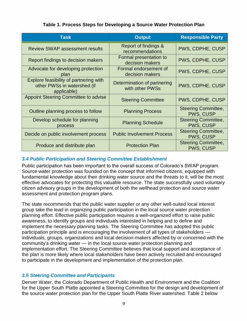
9
Table 1. Process Steps for Developing a Source Water Protection Plan
Task Output Responsible Party
Review SWAP assessment results Report of findings & recommendations
PWS, CDPHE, CUSP
Report findings to decision makers Formal presentation to
decision makers PWS, CDPHE, CUSP
Advocate for developing protection plan
Formal endorsement of decision makers
PWS, CDPHE, CUSP
Explore feasibility of partnering with other PWSs in watershed (if
applicable)
Determination of partnering with other PWSs
PWS, CDPHE, CUSP
Appoint Steering Committee to advise
Steering Committee PWS, CDPHE, CUSP
Outline planning process to follow Planning Process Steering Committee,
PWS, CUSP
Develop schedule for planning process
Planning Schedule Steering Committee,
PWS, CUSP
Decide on public involvement process Public Involvement Process Steering Committee,
PWS, CUSP
Produce and distribute plan Protection Plan Steering Committee,
PWS, CUSP
3.4 Public Participation and Steering Committee Establishment
Public participation has been important to the overall success of Colorado’s SWAP program. Source water protection was founded on the concept that informed citizens, equipped with fundamental knowledge about their drinking water source and the threats to it, will be the most effective advocates for protecting this valuable resource. The state successfully used voluntary citizen advisory groups in the development of both the wellhead protection and source water assessment and protection program plans.
The state recommends that the public water supplier or any other well-suited local interest group take the lead in organizing public participation in the local source water protection planning effort. Effective public participation requires a well-organized effort to raise public awareness, to identify groups and individuals interested in helping and to define and implement the necessary planning tasks. The Steering Committee has adopted this public participation principle and is encouraging the involvement of all types of stakeholders — individuals, groups, organizations and local decision-makers affected by or concerned with the community’s drinking water — in the local source water protection planning and implementation effort. The Steering Committee believes that local support and acceptance of the plan is more likely where local stakeholders have been actively recruited and encouraged to participate in the development and implementation of the protection plan.
3.5 Steering Committee and Participants
Denver Water, the Colorado Department of Public Health and Environment and the Coalition for the Upper South Platte appointed a Steering Committee for the design and development of the source water protection plan for the Upper South Platte River watershed. Table 2 below
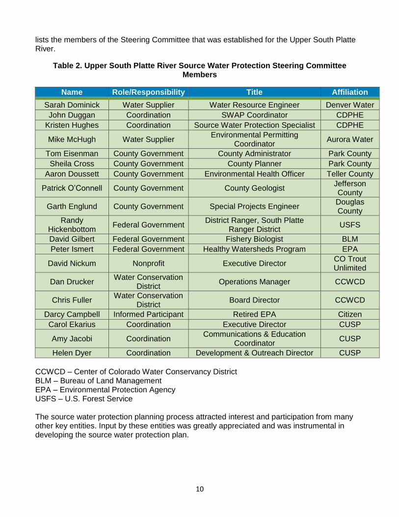
10
lists the members of the Steering Committee that was established for the Upper South Platte River.
Table 2. Upper South Platte River Source Water Protection Steering Committee Members
Name Role/Responsibility Title Affiliation
Sarah Dominick Water Supplier Water Resource Engineer Denver Water
John Duggan Coordination SWAP Coordinator CDPHE
Kristen Hughes Coordination Source Water Protection Specialist CDPHE
Mike McHugh Water Supplier Environmental Permitting
Coordinator Aurora Water
Tom Eisenman County Government County Administrator Park County
Sheila Cross County Government County Planner Park County
Aaron Doussett County Government Environmental Health Officer Teller County
Patrick O’Connell County Government County Geologist Jefferson County
Garth Englund County Government Special Projects Engineer Douglas County
Randy Hickenbottom
Federal Government District Ranger, South Platte
Ranger District USFS
David Gilbert Federal Government Fishery Biologist BLM
Peter Ismert Federal Government Healthy Watersheds Program EPA
David Nickum Nonprofit Executive Director CO Trout Unlimited
Dan Drucker Water Conservation
District Operations Manager CCWCD
Chris Fuller Water Conservation
District Board Director CCWCD
Darcy Campbell Informed Participant Retired EPA Citizen
Carol Ekarius Coordination Executive Director CUSP
Amy Jacobi Coordination Communications & Education
Coordinator CUSP
Helen Dyer Coordination Development & Outreach Director CUSP
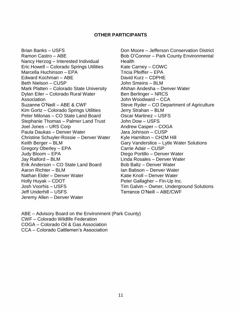
CCWCD – Center of Colorado Water Conservancy District BLM – Bureau of Land Management EPA – Environmental Protection Agency USFS – U.S. Forest Service The source water protection planning process attracted interest and participation from many other key entities. Input by these entities was greatly appreciated and was instrumental in developing the source water protection plan.
11
OTHER PARTICIPANTS
Brian Banks – USFS Ramon Castro – ABE Nancy Herzog – Interested Individual Eric Howell – Colorado Springs Utilities Marcella Huchinson – EPA Edward Kochman – ABE Beth Nielson – CUSP Mark Platten – Colorado State University Dylan Eiler – Colorado Rural Water Association Suzanne O’Neill – ABE & CWF Kim Gortz – Colorado Springs Utilities Peter Milonas – CO State Land Board Stephanie Thomas – Palmer Land Trust Joel Jones – URS Corp Paula Daukas – Denver Water Christine Schuyler-Rossie – Denver Water Keith Berger – BLM Gregory Oberley – EPA Judy Bloom – EPA Jay Raiford – BLM Erik Anderson – CO State Land Board Aaron Richter – BLM Nathan Elder – Denver Water Holly Huyak – CDOT Josh Voorhis – USFS Jeff Underhill – USFS Jeremy Allen – Denver Water
Don Moore – Jefferson Conservation District Bob O’Connor – Park County Environmental Health Kate Carney – COWC Tricia Pfeiffer – EPA David Kurz – CDPHE John Smeins – BLM Afshan Andesha – Denver Water Ben Berlinger – NRCS John Woodward – CCA Steve Ryder – CO Department of Agriculture Jerry Strahan – BLM Oscar Martinez – USFS John Dow – USFS Andrew Casper – COGA Jara Johnson – CUSP Kyle Hamilton – CH2M Hill Gary Vanderslice – Lytle Water Solutions Carrie Adair – CUSP Diego Portillo – Denver Water Linda Rosales – Denver Water Bob Baltz – Denver Water Ian Babson – Denver Water Katie Knoll – Denver Water Peter Gallagher – Fin-Up Inc. Tim Galvin – Owner, Underground Solutions Terrance O’Neill – ABE/CWF
ABE – Advisory Board on the Environment (Park County)CWF – Colorado Wildlife Federation COGA – Colorado Oil & Gas Association CCA – Colorado Cattlemen’s Association
12
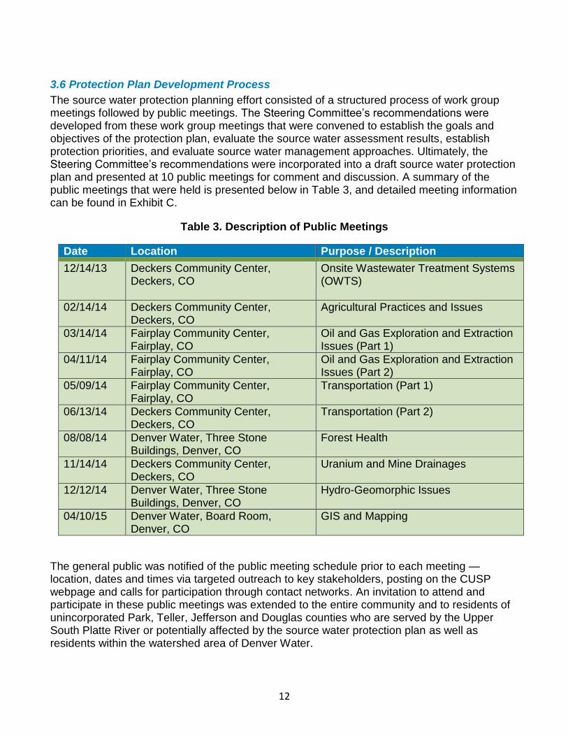
3.6 Protection Plan Development Process
The source water protection planning effort consisted of a structured process of work group meetings followed by public meetings. The Steering Committee’s recommendations were developed from these work group meetings that were convened to establish the goals and objectives of the protection plan, evaluate the source water assessment results, establish protection priorities, and evaluate source water management approaches. Ultimately, the Steering Committee’s recommendations were incorporated into a draft source water protection plan and presented at 10 public meetings for comment and discussion. A summary of the public meetings that were held is presented below in Table 3, and detailed meeting information can be found in Exhibit C.
Table 3. Description of Public Meetings
Date Location Purpose / Description
12/14/13 Deckers Community Center, Deckers, CO
Onsite Wastewater Treatment Systems (OWTS)
02/14/14 Deckers Community Center, Deckers, CO
Agricultural Practices and Issues
03/14/14 Fairplay Community Center, Fairplay, CO
Oil and Gas Exploration and Extraction Issues (Part 1)
04/11/14 Fairplay Community Center, Fairplay, CO
Oil and Gas Exploration and Extraction Issues (Part 2)
05/09/14 Fairplay Community Center, Fairplay, CO
Transportation (Part 1)
06/13/14 Deckers Community Center, Deckers, CO
Transportation (Part 2)
08/08/14 Denver Water, Three Stone Buildings, Denver, CO
Forest Health
11/14/14 Deckers Community Center, Deckers, CO
Uranium and Mine Drainages
12/12/14 Denver Water, Three Stone Buildings, Denver, CO
Hydro-Geomorphic Issues
04/10/15 Denver Water, Board Room, Denver, CO
GIS and Mapping
The general public was notified of the public meeting schedule prior to each meeting — location, dates and times via targeted outreach to key stakeholders, posting on the CUSP webpage and calls for participation through contact networks. An invitation to attend and participate in these public meetings was extended to the entire community and to residents of unincorporated Park, Teller, Jefferson and Douglas counties who are served by the Upper South Platte River or potentially affected by the source water protection plan as well as residents within the watershed area of Denver Water.
13
4.0 WATER SUPPLY SETTING
14
4.0 WATER SUPPLY SETTING
4.1 Hydrogeographic and Water Quality Setting – Surface Water Systems
The Upper South Platte River is one of the sources that supplies drinking water to the residents within the service area of Denver Water as well as other public utilities and private users both in the watershed and on the Front Range of Colorado. Denver Water serves approximately 1.3 million people and is predominantly a metropolitan community.
The Upper South Platte River watershed conveys water native to both the South Platte River and Blue River watersheds. Water is diverted from the Blue River watershed via the Roberts Tunnel to the North Fork of the South Platte River. It should be noted however that for the purpose of this source water protection plan, only the South Platte River watershed is assessed. The Blue River watershed has already developed and implemented a source water protection plan. The Upper South Platte River is primarily fed directly from snowmelt and diversions through the Roberts Tunnel. Elevations within the source water area range from 5,512 feet near Kassler, Colorado to 14,271 feet at Mt. Evans. The climate within the source water area includes alpine forests, high elevation grasslands and lower elevation forests with annual average precipitation ranging from less than 12 inches to greater than 30 inches.
The water quality of the untreated source water is measured against various use classifications and water quality standards that are established and periodically reassessed by the Colorado Department of Public Health and Environment and the Water Quality Control Commission for Colorado’s rivers and streams. Currently, most of the stream segments located above Denver Water’s intakes are classified to protect drinking water use. For the stream segments with a drinking water use classification, drinking water standards have been established for the constituents in Table 4.
Table 4. Constituents with Established Drinking Water Standards
Physical & Biological Inorganic Metals
Dissolved Oxygen, pH and E. Coli
Residual Chlorine, Free Cyanide, Boron, Nitrite, Nitrate, Chloride, Total Phosphorous and Sulfate
Antimony, Arsenic, Barium, Beryllium, Cadmium, Chromium, Copper, Iron, Lead, Manganese, Mercury, Molybdenum, Nickel, Selenium, Silver, Thallium, Uranium and Zinc
These stream standards are a reflection of known water quality conditions, as well as historic land uses within the Upper South Platte River watershed. Drinking water classifications and associated water quality standards provide public water systems and communities with a mechanism for monitoring and protecting the quality of their source water.
15
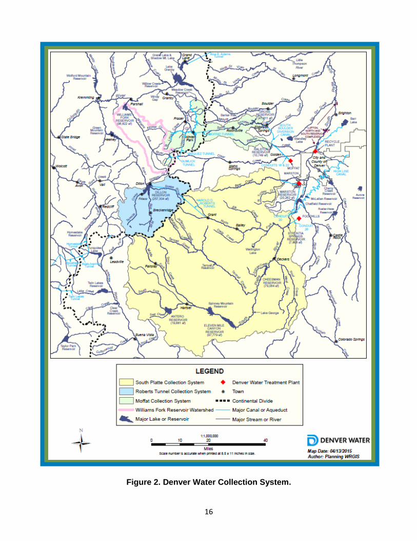
4.2 Drinking Water Supply Operation
Denver Water maintains and operates a water system that serves the residents of Denver, Colorado and the surrounding communities and businesses within the Denver Water service area. The water system is operated by employees of Denver Water.
Denver Water utilizes an intake at Strontia Springs Reservoir and one just downstream in Waterton Canyon located southwest of Denver to get water from the Upper South Platte River watershed into its system. The raw water diverted from the surface water intakes is sent to two surface water treatment plants (Foothills and Marston) to be treated prior to distributing the drinking water to the water system’s customers. The treatment systems have a maximum capacity to treat a total of 500 million gallons of drinking water per day (MGD) (280 MGD at Foothills Water Treatment Plant and 220 MGD at the Marston Water Treatment Plant). Once the water is treated at any of Denver Water’s three water treatment plants (Foothills, Marston and Moffat), it becomes part of an integrated water system and is treated as one. Its storage and distribution is not separated by the source from where the water supply originated. The water system stores untreated source water in multiple storage reservoirs prior to treatment and stores its treated water in 24 storage tanks within the drinking water distribution system. Denver Water has the maximum capacity to store 374.7 million gallons of treated drinking water in reservoirs alone and 671.4 million gallons in the distribution system as a whole.
16
Figure 2. Denver Water Collection System.
17
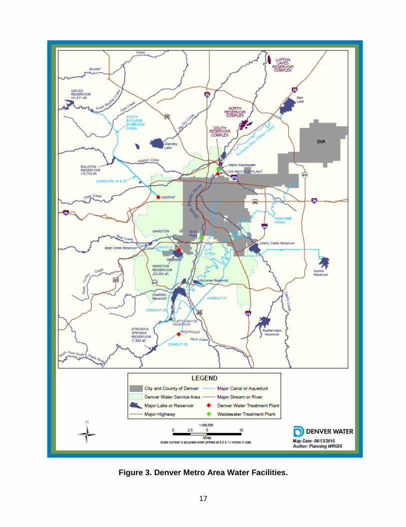
Figure 3. Denver Metro Area Water Facilities.
18
4.3 Water Supply Demands and Analysis
The water system serves an estimated 313,035 potable connections, approximately 100 recycled water connections and approximately 1.3 million residents and other users in the service area annually. The water system currently has the capacity of meeting a peak (i.e., maximum) daily demand of 685 MGD. Current estimates by the water system indicate that the average daily demand by the water system’s customers is approximately 185 MGD (averaged over 2008-2013), and that the average peak daily demand is approximately 374 MGD (averaged over 2008-2013). Using these estimates, the water system has a surplus average daily demand capacity of 500 MGD and a surplus average peak daily demand capacity of 311 MGD (calculations shown in Exhibit D). Using the surplus estimates above, Denver Water has evaluated its ability to meet the average daily demand and the average peak daily demand of its customers in the event the water supply from one or more of its water sources becomes disabled for an extended period of time due to potential contamination. The evaluation indicated that Denver Water may not be able to meet the average daily or the average peak daily demand of its customers if the Upper South Platte River watershed became disabled for an extended period of time. This is especially important to plan for since three quarters of Denver Water’s water supply flows through the Upper South Platte River watershed. The ability of Denver Water to meet either of these demands for an extended period of time is also affected by the amount of treated water the water system has in storage at the time a water source becomes disabled.
The potential financial and water supply risks related to the long-term disablement of one or more of its water sources are a concern to Denver Water. While it is hard to quantify, it is estimated to cost $1.7 billion to replace the water lost if Denver Water could no longer rely on the USPR as a water supply source. As a result, the Steering Committee and Denver Water believe the development and implementation of a source water protection plan for the Upper South Platte River watershed can help to reduce the financial risks posed by potential contamination of its water source.
4.4 Growth and Land Use Projections
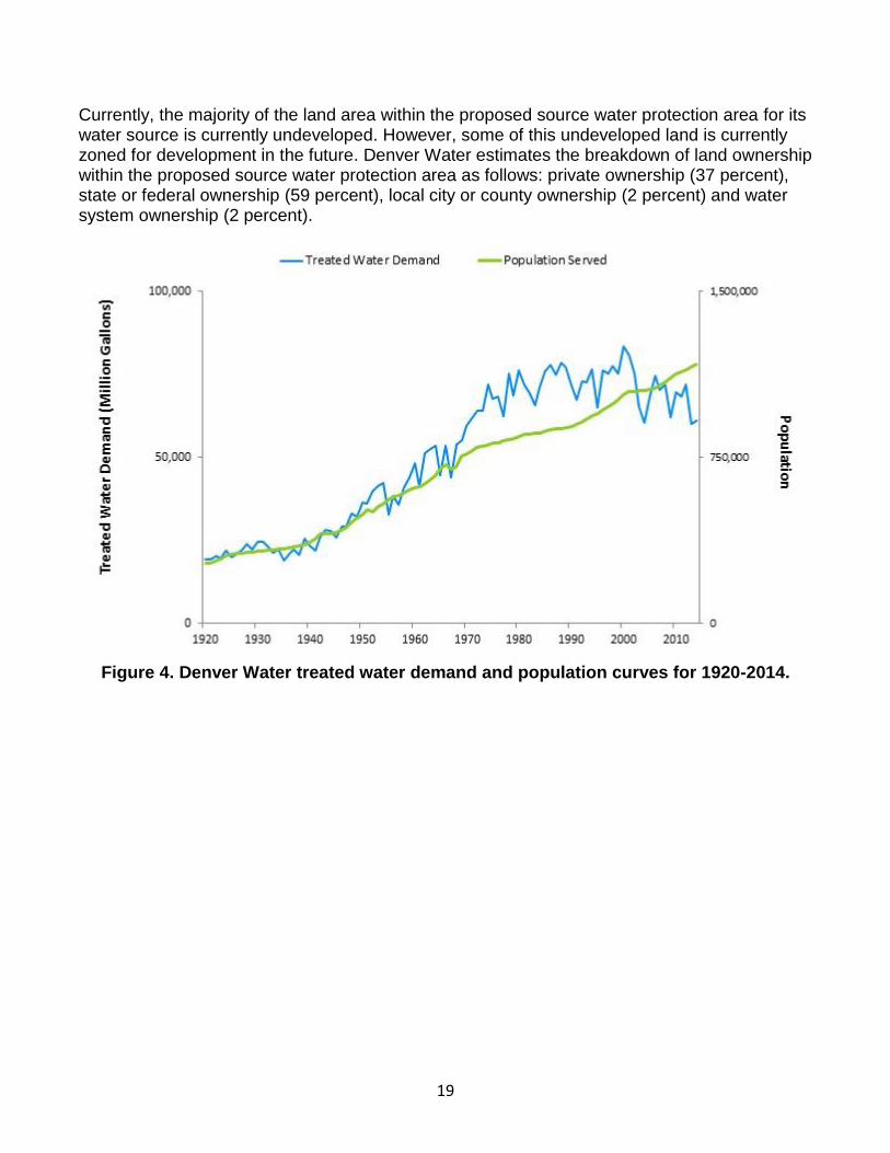
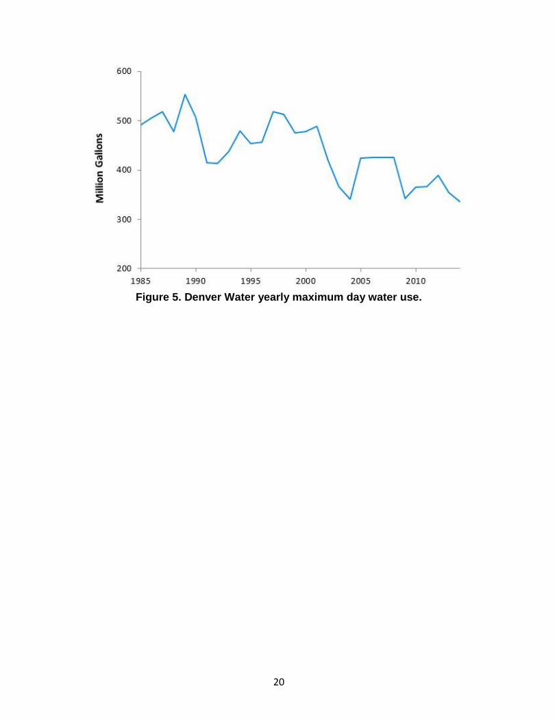
The latest census information indicated a population of 1.3 million for the Denver Water service area. Based on the latest and previous census information, Denver Water has been experiencing an increase in population growth within the community and future projections estimate that the population will continue to grow. However, increased population does not directly correlate to increased water usage, as shown in the figures below. Figure 4 shows that until the mid-1960s, water use and population grew at approximately the same rate. Just after that, the population continued to grow at the same rate, but water use spiked dramatically. Water use remained fairly steady for the following 30 years and then dropped in 2000 and has remained consistently lower, despite continued population increase. Figure 5 shows that maximum day water use has decreased since 1985. The inability to accurately predict water use based on population growth underscores the challenges associated with predicting future water use. As a result of this uncertainty, it is vital to protect the water sources that Denver Water has in order to prepare for multiple water use scenarios and provide the ability to quickly adapt to changes if water use suddenly diverges from its prediction.
19
Currently, the majority of the land area within the proposed source water protection area for its water source is currently undeveloped. However, some of this undeveloped land is currently zoned for development in the future. Denver Water estimates the breakdown of land ownership within the proposed source water protection area as follows: private ownership (37 percent), state or federal ownership (59 percent), local city or county ownership (2 percent) and water system ownership (2 percent).
Figure 4. Denver Water treated water demand and population curves for 1920-2014.
20
Figure 5. Denver Water yearly maximum day water use.
21
5.0 SOURCE WATER
ASSESSMENT RESULT
22
5.0 SOURCE WATER ASSESSMENT RESULTS
The Colorado Department of Public Health and Environment assumed the lead role in conducting the initial source water assessments for public water systems in Colorado. Denver Water received their source water assessment report in November 2004 and has reviewed the report along with the Steering Committee. Denver Water and the Steering Committee are committed to using these results as a starting point to guide the development of appropriate management approaches to protect their source water from potential contamination. A copy of the source water assessment summary report for the Upper South Platte River watershed can be obtained by contacting Denver Water or by downloading a copy from the Colorado Department of Public Health and Environment’s SWAP program website at: www.cdphe.state.co.us/wq/sw/swaphom.html. The following sections provide a brief summary of the main findings from the three component phases of the assessment.
5.1 Source Water Assessment Area Delineation – Surface Water Systems
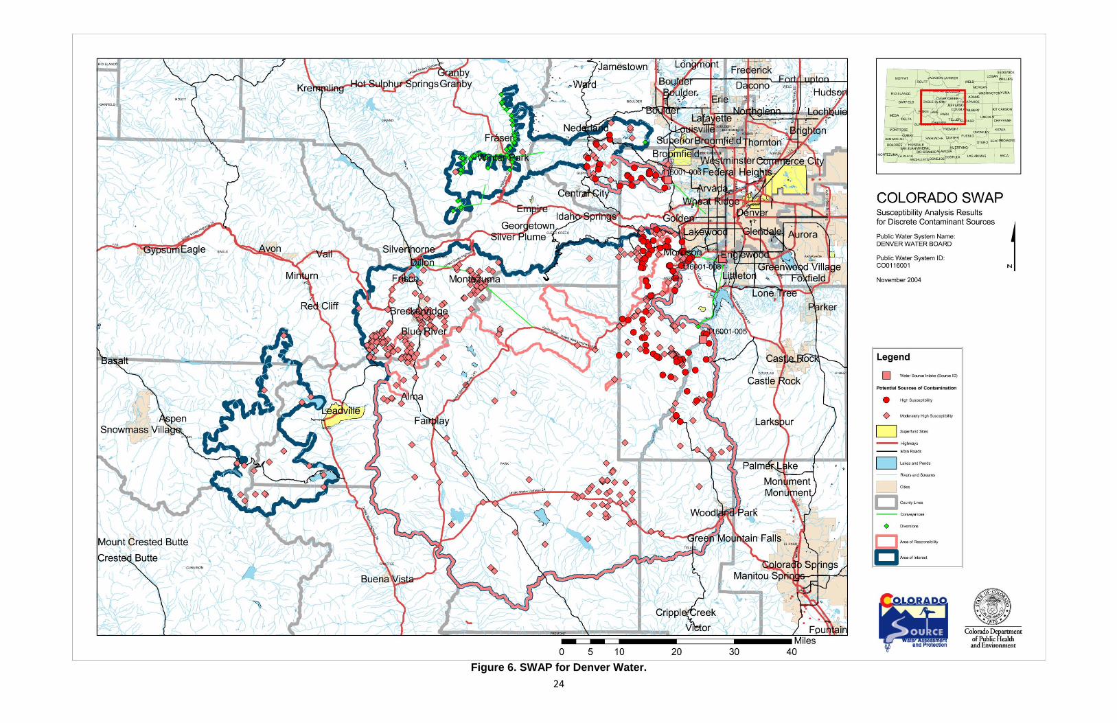
The source water assessment area provided to Denver Water from the Colorado Department of Public Health and Environment includes portions of the following watersheds: Upper South Platte, Blue, Frying Pan, Eagle, Arkansas, Fraser, Williams Fork, South Boulder and Ralston. For the purpose of this plan for the Upper South Platte, the area consists of approximately a 2,600-square-mile area draining the Upper South Platte River watershed. The Colorado Department of Public Health and Environment provided Denver Water with a draft map of their source water assessment area (Figure 6) and asked them to voluntarily review and comment on its accuracy.
The delineated source water assessment area not only provides the basis for understanding where the community’s source water and potential contaminant threats originate, but also provides the basis for establishing the source water protection area under this source water protection plan. Further discussion is provided in a later section on the source water protection area that was established under this plan.
5.2 Contaminant Source Inventory
Notice to readers: The information contained in this plan is limited to that available from public records and the water supplier. Other potential contaminant sites or threats to the water supply may exist in the source water assessment area that are not identified in this plan. Identification of a site as a potential contaminant site should not be interpreted as one that will necessarily cause contamination of the water supply.
The contaminant source inventory was conducted to identify whether or not selected potential sources of contamination might be present within the source water assessment area. The Colorado Department of Public Health and Environment inventoried discrete contaminant sources using selected state and federal regulatory databases. Dispersed contaminant sources were inventoried using a recent land use/ land cover and transportation maps of Colorado, along with selected state regulatory databases. The contaminant inventory was
23
completed by mapping the potential contaminant sources with the aid of a Geographic Information System (GIS).
The Colorado Department of Public Health and Environment provided Denver Water with a draft map, a summary of the discrete contaminant sources mapped within their source water assessment area and a summary of the dispersed contaminant sources inventoried within the source water assessment area. Denver Water was asked to voluntarily review the inventory information, field verify selected information about existing and new discrete contaminant sources and provide feedback on the accuracy of the inventory.
Discrete Potential Sources of Contamination The contaminant source inventory results for the Upper South Platte River watershed indicate the following types of discrete contaminant sources were identified within the source water assessment area for all of the surface water sources analyzed:
EPA Abandoned Contaminated Sites (CERCLA)
EPA Hazardous Waste Generators (HWLQG, HWSQG, HWTSD)
EPA Chemical Inventory/Storage Sites (SARA)
EPA Toxic Release Inventory Sites (TRI)
Permitted Wastewater Discharge Sites (PCS)
Aboveground, Underground and Leaking Storage Tank Sites (TANKFAC)
Solid Waste Sites (SWSITE)
Existing/Abandoned Mine Sites (MASMIL)
Other Facilities (OGFAC, PSWFB, SIC, WHP)
Dispersed Potential Sources of Contamination The contaminant source inventory results for the Upper South Platte River watershed indicate the following types of dispersed contaminant sources were identified within the source water assessment area for all of the surface water sources analyzed:
Land Uses:
Commercial/Industrial/Transportation
Low Intensity Residential
Urban Recreational Grasses
Quarries/Strip Mines/Gravel Pits
Row Crops
Fallow
Pasture/Hay
Deciduous Forest
Evergreen Forest
Mixed Forest Other Types:
Septic Systems
Oil & Gas Wells
Road Miles
24
Figure 6. SWAP for Denver Water.
25
5.3 Source Water Protection Priority Strategy and Susceptibility Analysis
After reviewing the source water assessment results for the Upper South Platte River watershed, the Steering Committee adopted the two-step strategy recommended by the Colorado Department of Public Health and Environment for prioritizing the water sources and potential contaminant sources on which source water protection measures will be focused.
The strategy calls for water sources with total susceptibility ratings or physical setting vulnerability ratings of Moderately High or High to be prioritized as the first step in the process. A Moderately High or High total susceptibility rating indicates that the water source is proportionately more susceptible to potential contamination overall when compared to other similar types of water sources around the state. Higher total susceptibility ratings most typically result for water sources with highly vulnerable physical settings and a source water assessment area containing several potential contaminant sources that pose a significant threat to potential contamination. A Moderately High or High physical setting rating indicates a diminished ability of the physical setting of the source water assessment area to buffer contaminant concentrations in the source water below acceptable levels and, therefore it is more vulnerable to potential contamination. Even in cases where few if any potential contaminant sources are currently present, a water source with a highly vulnerable physical setting could be very susceptible to future contamination depending on the type of potential contaminant sources that might be introduced. The strategy also outlines three options for prioritizing discrete and dispersed potential contaminant sources for source water protection measures as the second step of the process. These options include prioritizing source water protection measures based on:
Most prevalent contaminant sources: Under this option, protection measures would be focused on the discrete and dispersed contaminant sources that occur most frequently in the water system’s source water protection area, regardless of the individual susceptibility ratings they may have received.
Most threatening contaminant sources: Under this option, protection measures would be focused on the individual discrete and dispersed contaminant sources in the water system’s source water protection area to which the water source is most susceptible. The most threatening contaminant sources are defined as any potential contaminant source receiving a Moderately High or High individual susceptibility rating.
Most prevalent and threatening contaminant sources: Under this option, protection measures would be focused on the most frequently occurring discrete and dispersed contaminant sources in the water system’s source water protection area that received a Moderately High or High individual susceptibility rating.
In applying this strategy, the Steering Committee recommends focusing source water protection measures on the Upper South Platte River watershed, and the most prevalent and threatening discrete contaminant sources and the most prevalent dispersed contaminant sources contained in the source water protection area for this water source. The Steering
26
Committee chose to solely look at the most prevalent dispersed contaminant sources because there were no threatening sources in the Upper South Platte River watershed.
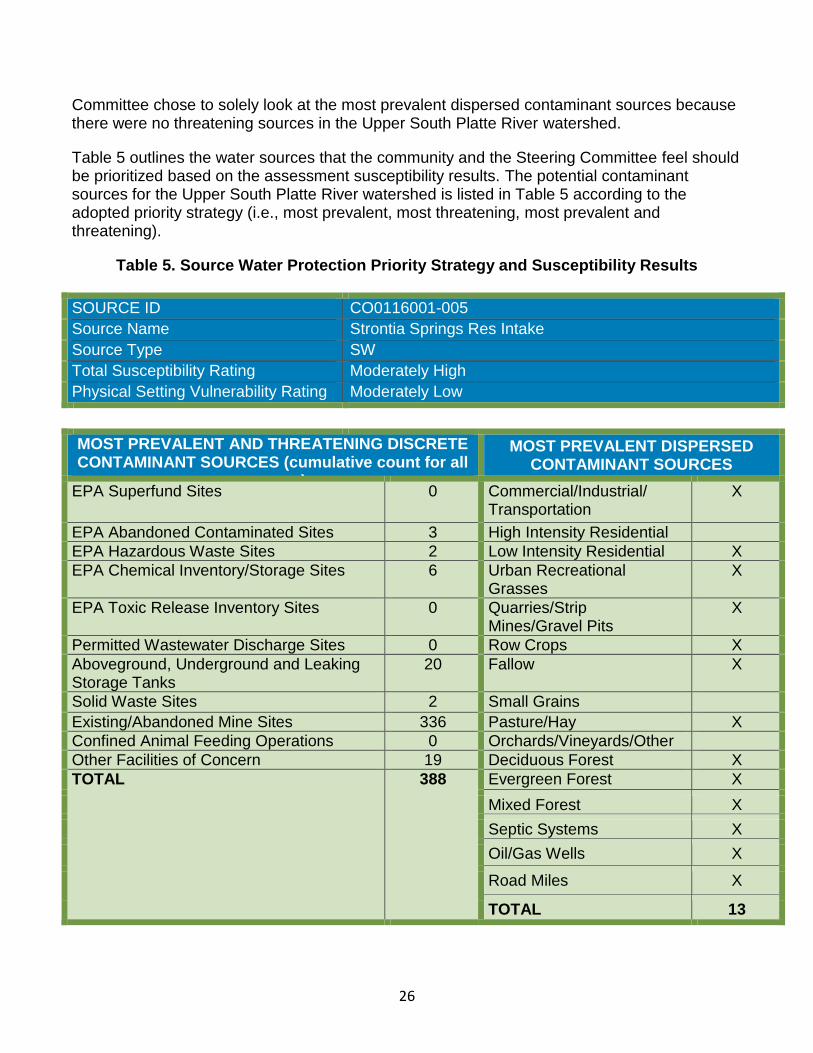
Table 5 outlines the water sources that the community and the Steering Committee feel should be prioritized based on the assessment susceptibility results. The potential contaminant sources for the Upper South Platte River watershed is listed in Table 5 according to the adopted priority strategy (i.e., most prevalent, most threatening, most prevalent and threatening).
Table 5. Source Water Protection Priority Strategy and Susceptibility Results
SOURCE ID CO0116001-005
Source Name Strontia Springs Res Intake
Source Type SW
Total Susceptibility Rating Moderately High
Physical Setting Vulnerability Rating Moderately Low
MOST PREVALENT AND THREATENING DISCRETE CONTAMINANT SOURCES (cumulative count for all
sources)
MOST PREVALENT DISPERSED CONTAMINANT SOURCES
EPA Superfund Sites 0 Commercial/Industrial/ Transportation
X
EPA Abandoned Contaminated Sites 3 High Intensity Residential
EPA Hazardous Waste Sites 2 Low Intensity Residential X
EPA Chemical Inventory/Storage Sites 6 Urban Recreational Grasses
X
EPA Toxic Release Inventory Sites 0 Quarries/Strip Mines/Gravel Pits
X
Permitted Wastewater Discharge Sites 0 Row Crops X
Aboveground, Underground and Leaking Storage Tanks
20 Fallow X
Solid Waste Sites 2 Small Grains
Existing/Abandoned Mine Sites 336 Pasture/Hay X
Confined Animal Feeding Operations 0 Orchards/Vineyards/Other
Other Facilities of Concern 19 Deciduous Forest X
TOTAL 388 Evergreen Forest X
Mixed Forest X
Septic Systems X
Oil/Gas Wells X
Road Miles X
TOTAL 13
27
5.4 Susceptibility Analysis
Notice to readers: The susceptibility analysis provides a screening-level evaluation of the likelihood that a potential contamination problem could occur rather than an indication that a potential contamination problem has occurred or will occur. The analysis is NOT a reflection of the current quality of the untreated source water, nor is it a reflection of the quality of the treated drinking water that is supplied to the public.
The susceptibility analysis was conducted by the Colorado Department of Public Health and Environment to identify how susceptible an untreated water source could be to contamination from potential sources of contamination inventoried within its source water assessment area. The analysis looked at the susceptibility posed by individual potential contaminant sources and the collective or total susceptibility posed by all of the potential contaminant sources in the source water assessment area. The Colorado Department of Public Health and Environment developed a susceptibility analysis model for surface water sources and ground water sources under the influence of surface water. The CDPHE also developed another model strictly for ground water sources. Both models provided an objective analysis based on the best available information at the time of the analysis. The Colorado Department of Public Health and Environment provided Denver Water with a final source water assessment report and supporting analysis information.
Table 5 on the previous page presents the priority strategy and the susceptibility analysis results for selected water sources for Denver Water. The table summarizes the total susceptibility and physical setting vulnerability results, as well as the individual susceptibility results for the discrete and dispersed contaminant sources associated with each of the water sources that have been prioritized for source water protection measures under this plan. As a starting point, these water sources have been prioritized based on the source water protection priority strategy recommended by the Steering Committee. The priority strategy was discussed previously, in section 5.3 (Source Water Protection Priority Strategy and Susceptibility Analysis).
28
6.0 SOURCE WATER
PROTECTION MEASURES
29
6.0 SOURCE WATER PROTECTION MEASURES
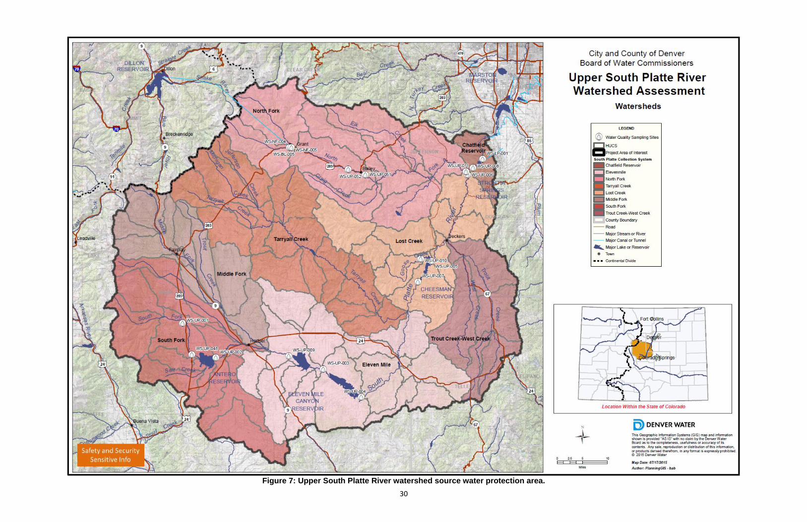
6.1 Defining the Source Water Protection Area
The source water protection area defines either the watershed region or the surficial region overlying the local aquifer where the community has chosen to implement its source water protection measures in an attempt to manage the susceptibility of their source water to potential contamination. The Steering Committee chose the Upper South Platte River Watershed Protection Area (Figure 7) as the source water protection area. They did not, however, choose the other watersheds discussed in Section 5.1.
The Steering Committee considered several factors in defining the source water protection area in this manner. The Upper South Platte watershed was chosen because it is the largest of Denver Water’s source water watersheds (2,600 square miles) and provides approximately 75 percent of the source water to Denver Water’s 1.3 million customers. After the Upper South Platte River Watershed Source Water Protection Plan has been implemented (and necessary changes have been addressed) the planning process will be implemented into the remaining watersheds.
30
Figure 7: Upper South Platte River watershed source water protection area.
31
6.2 Identifying the Categories of Contaminants for Discrete Contaminant Sources
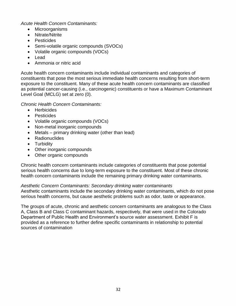
The most common categories of contaminants that are most likely associated with the most prevalent and threatening discrete contaminant sources identified in Table 5 include: Acute Health Concern Contaminants:
Microorganisms
Nitrate/Nitrite
Pesticides
Semi-volatile organic compounds (SVOCs)
Volatile organic compounds (VOCs)
Lead
Ammonia or nitric acid
Acute health concern contaminants include individual contaminants and categories of constituents that pose the most serious immediate health concerns resulting from short-term exposure to the constituent. Many of these acute health concern contaminants are classified as potential cancer-causing (i.e., carcinogenic) constituents or have a Maximum Contaminant Level Goal (MCLG) set at zero. Chronic Health Concern Contaminants:
Herbicides
Pesticides
Volatile organic compounds (VOCs)
Non-metal inorganic compounds
Metals – primary drinking water (other than lead)
Turbidity
Other inorganic compounds
Other organic compounds
Chronic health concern contaminants include categories of constituents that pose potential serious health concerns due to long-term exposure to the constituent. Most of these chronic health concern contaminants include the remaining primary drinking water contaminants.
Aesthetic Concern Contaminants: Secondary drinking water contaminants Aesthetic contaminants include the secondary drinking water contaminants, which do not pose serious health concerns, but cause aesthetic problems such as odor, taste or appearance.
The groups of acute, chronic and aesthetic concern contaminants are analogous to the Class A, Class B and Class C contaminant hazards, respectively, that were used in the Colorado Department of Public Health and Environment’s source water assessment. Exhibit F is provided as a reference to further define specific contaminants in relationship to potential sources of contamination.
6.3 Identifying the Categories of Contaminants for Dispersed Contaminant Sources
The most common categories of contaminants that are most likely associated with the most prevalent and threatening dispersed contaminant sources identified in Table 5 include the following:
32
Acute Health Concern Contaminants:
Microorganisms
Nitrate/Nitrite
Pesticides
Semi-volatile organic compounds (SVOCs)
Volatile organic compounds (VOCs)
Lead
Ammonia or nitric acid
Acute health concern contaminants include individual contaminants and categories of constituents that pose the most serious immediate health concerns resulting from short-term exposure to the constituent. Many of these acute health concern contaminants are classified as potential cancer-causing (i.e., carcinogenic) constituents or have a Maximum Contaminant Level Goal (MCLG) set at zero (0).
Chronic Health Concern Contaminants:
Herbicides
Pesticides
Volatile organic compounds (VOCs)
Non-metal inorganic compounds
Metals – primary drinking water (other than lead)
Radionuclides
Turbidity
Other inorganic compounds
Other organic compounds
Chronic health concern contaminants include categories of constituents that pose potential serious health concerns due to long-term exposure to the constituent. Most of these chronic health concern contaminants include the remaining primary drinking water contaminants.
Aesthetic Concern Contaminants: Secondary drinking water contaminants Aesthetic contaminants include the secondary drinking water contaminants, which do not pose serious health concerns, but cause aesthetic problems such as odor, taste or appearance.
The groups of acute, chronic and aesthetic concern contaminants are analogous to the Class A, Class B and Class C contaminant hazards, respectively, that were used in the Colorado Department of Public Health and Environment’s source water assessment. Exhibit F is provided as a reference to further define specific contaminants in relationship to potential sources of contamination
33
6.4 Source Water Protection Area Management and Commitment
The Steering Committee reviewed and discussed several possible source water management approaches that could be implemented within the source water protection area to help reduce the risks of potential contamination of the community’s source water. The purpose of voluntarily implementing source water management approaches is to apply an additional level of protection to the drinking water supply by taking preventive measures at the local level (i.e., county and municipal) to protect source water. These local preventive measures will compliment regulatory protection measures already being implemented at the state and federal governmental levels by filling protection gaps that can only be addressed at the local level. The Steering Committee is confident that applying these management approaches is a cost-effective, commonsense approach in helping to reduce the risks of costly service disruptions resulting from potential contamination of the source water.
The Steering Committee established certain acceptance criteria as part of identifying and selecting the most feasible source water management approaches to implement locally. The Steering Committee developed a list of topic areas which address the potential sources of contamination and arranged for experts to present information on those identified topic areas. Experts presented a range of information including background, current state of source water protection with regards to their topic and what could be improved. Following the expert presentations, the Steering Committee identified the relevant best management practices (BMPs) to be implemented in the Upper South Platte River SWPP.
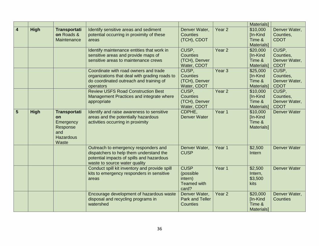
The Steering Committee recommends the following table of source water management tools to be implemented by Denver Water in collaboration with the Park, Teller, Jefferson and Douglas county planning commissions. Please note in the following table that when TCH is listed in parentheses following “County Planning Departments,” that the Tri-County Health (TCH) department will be implementing the BMP instead of Douglas County. Due to the size of this watershed, it was not possible to create a number-ordered list. Instead, the list is prioritized on a high, medium-high, and medium priority basis, which is identified in Table 6. Exhibit H, the BMP Checklist, provides detailed information about the tools laid out in Table 6.
34
Table 6. Source Water Protection Priorities and Best Management Practices (Applied to CO0116001-005)
Issue #
Initial Steering
Committee Priority Ranking Priority Issue Best Management Practices
Implementation
Responsibility
Proposed Implementatio
n Schedule
Estimated
Cost
Proposed Funding Sources
1 High/ Medium
On-site Wastewater Treatment Systems (OWTS)
Coordinate GIS overlays and mapping to identify sensitive areas
Denver Water, County Planning Departments (TCH), CUSP
Year 1 $10,000 [In-Kind Time & Materials]
Denver Water, County Planning Departments, CUSP
In sensitive areas, perform surface water monitoring for nutrients and other potential contaminants
Denver Water, CUSP
Year 2 $20,000 [In-Kind Time & Materials]
Denver Water, CUSP
Using targeted public outreach, develop effective OWTS awareness to inform landowners and realtors of BMPs
Denver Water, County Planning Departments (TCH), CUSP
Year 3 $10,000 [In-Kind Time & Materials]
Denver Water, County Planning Departments, CUSP
Review OWTS regulations and standards NAWT, County Enviro Health & Building Depts, TCH
July 2014 & ongoing
$20,000 [In-Kind Time & Materials]
County Enviro Health & Building Depts
Encourage OWTS inspections and record submittals on property transfers
Denver Water, County Planning & Health Depts, TCH
Year 2 $15,000 [In-Kind Time & Materials]
Denver Water, County Planning & Health Depts
2 High Agriculture Practices
Identify sensitive drinking water areas adjacent to and downstream of agricultural operations
Denver Water, Counties, BLM, CUSP
Year 1 $10,000 [In-Kind Time & Materials]
Denver Water, Counties, BLM, CUSP
Draft standardized language and policies for grazing contracts between large landowners, land use managers and ranchers
USFS, BLM, CO Cattlemen’s Assoc., Denver
Year 1 $10,000 [In-Kind Time & Materials]
Denver Water, CUSP, with review time from others
35
Water, CO State Forest Service, CPW, SLB
$2,000 Intern
Using targeted education tools, develop effective agricultural practices materials to inform landowners and real estate industry of BMPs
USFS, BLM, CO Cattlemen’s Assoc., Denver Water, CO State Forest Service, CPW, SLB
Year 3 $20,000 [In-Kind Time & Materials]
Denver Water, CUSP, with review time from others
Identify and promote funding opportunities for landowners to improve agricultural practices
NRCS, CSU Extension, USDA, Counties (TCH), 4H
Year 2 $15,000 [In-Kind Time & Materials]
Denver Water, Counties [funding opportunities from NRCS, non-profits, others]
Research the availability of augmentation water or regulatory alternatives for off channel livestock watering
Denver Water, Counties (TCH), BLM, CUSP
Year 3 $15,000 [In-Kind Time & Materials]
Denver Water
3 High/ Medium
Oil & Gas Exploration
Participate in the BLM Master Leasing Plan process and the Pike and Saint Isabel National Forests Oil and Gas Leasing process
USFS, BLM, Denver Water, CSFS, CPW, COGCC, COGA, State Land Board
Year 1 $10,000 [In-Kind Time & Materials]
USFS, BLM, Denver Water, CSFS, CPW, COGCC, COGA, State Land Board
Work with other counties to raise awareness of BMPs for oil and gas development
Counties (TCH), Landowners, COGCC, COGA, EPA, State Land Board, BLM
Ongoing $20,000 [In-Kind Time & Materials]
Counties, Landowners, COGCC, COGA, EPA, State Land Board, BLM
Monitor oil and gas leasing on Denver Water properties
Denver Water Ongoing $10,000 [In-Kind Time &
Denver Water
36
Materials]
4 High Transportation Roads & Maintenance
Identify sensitive areas and sediment potential occurring in proximity of these areas
Denver Water, Counties (TCH), CDOT
Year 2 $10,000 [In-Kind Time & Materials]
Denver Water, Counties, CDOT
Identify maintenance entities that work in sensitive areas and provide maps of sensitive areas to maintenance crews
CUSP, Counties (TCH), Denver Water, CDOT
Year 2 $20,000 [In-Kind Time & Materials]
CUSP, Counties, Denver Water, CDOT
Coordinate with road owners and trade organizations that deal with grading roads to do coordinated outreach and training of operators
CUSP, Counties (TCH), Denver Water, CDOT
Year 3 $25,000 [In-Kind Time & Materials]
CUSP, Counties, Denver Water, CDOT
Review USFS Road Construction Best Management Practices and integrate where appropriate
CUSP, Counties (TCH), Denver Water, CDOT
Year 2 $10,000 [In-Kind Time & Materials]
CUSP, Counties, Denver Water, CDOT
5 High Transportation Emergency Response and Hazardous Waste
Identify and raise awareness to sensitive areas and the potentially hazardous activities occurring in proximity
CDPHE, Denver Water
Year 1 $10,000 [In-Kind Time & Materials]
Denver Water
Outreach to emergency responders and dispatchers to help them understand the potential impacts of spills and hazardous waste to source water quality
Denver Water, CUSP
Year 1 $2,500 Intern
Denver Water
Conduct spill kit inventory and provide spill kits to emergency responders in sensitive areas
CUSP (possible intern) Teamed with card?
Year 1 $2,500 Intern, $3,500 kits
Denver Water
Encourage development of hazardous waste disposal and recycling programs in watershed
Denver Water, Park and Teller Counties
Year 2 $20,000 [In-Kind Time & Materials]
Denver Water, Counties
37
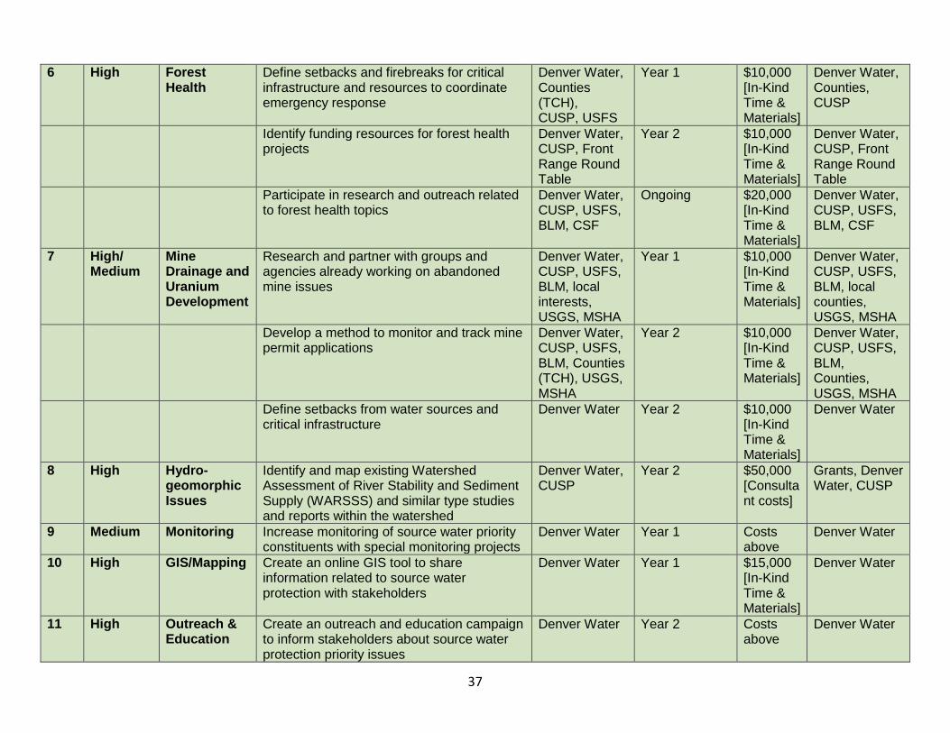
6 High Forest Health
Define setbacks and firebreaks for critical infrastructure and resources to coordinate emergency response
Denver Water, Counties (TCH), CUSP, USFS
Year 1 $10,000 [In-Kind Time & Materials]
Denver Water, Counties, CUSP
Identify funding resources for forest health projects
Denver Water, CUSP, Front Range Round Table
Year 2 $10,000 [In-Kind Time & Materials]
Denver Water, CUSP, Front Range Round Table
Participate in research and outreach related to forest health topics
Denver Water, CUSP, USFS, BLM, CSF
Ongoing $20,000 [In-Kind Time & Materials]
Denver Water, CUSP, USFS, BLM, CSF
7 High/ Medium
Mine Drainage and Uranium Development
Research and partner with groups and agencies already working on abandoned mine issues
Denver Water, CUSP, USFS, BLM, local interests, USGS, MSHA
Year 1 $10,000 [In-Kind Time & Materials]
Denver Water, CUSP, USFS, BLM, local counties, USGS, MSHA
Develop a method to monitor and track mine permit applications
Denver Water, CUSP, USFS, BLM, Counties (TCH), USGS, MSHA
Year 2 $10,000 [In-Kind Time & Materials]
Denver Water, CUSP, USFS, BLM, Counties, USGS, MSHA
Define setbacks from water sources and critical infrastructure
Denver Water Year 2 $10,000 [In-Kind Time & Materials]
Denver Water
8 High Hydro-geomorphic Issues
Identify and map existing Watershed Assessment of River Stability and Sediment Supply (WARSSS) and similar type studies and reports within the watershed
Denver Water, CUSP
Year 2 $50,000 [Consultant costs]
Grants, Denver Water, CUSP
9 Medium Monitoring Increase monitoring of source water priority constituents with special monitoring projects
Denver Water Year 1 Costs above
Denver Water
10 High GIS/Mapping
Create an online GIS tool to share information related to source water protection with stakeholders
Denver Water Year 1 $15,000 [In-Kind Time & Materials]
Denver Water
11 High Outreach & Education
Create an outreach and education campaign to inform stakeholders about source water protection priority issues
Denver Water Year 2 Costs above
Denver Water
38
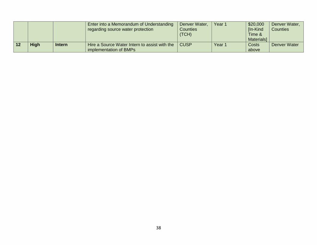
Enter into a Memorandum of Understanding regarding source water protection
Denver Water, Counties (TCH)
Year 1 $20,000 [In-Kind Time & Materials]
Denver Water, Counties
12 High Intern Hire a Source Water Intern to assist with the implementation of BMPs
CUSP Year 1 Costs above
Denver Water
39
6.5 Additional Commitments from Denver Water
Denver Water is committed to developing a tracking and reporting system to gauge the effectiveness of the various source water management approaches that have been implemented. The purpose of tracking and reporting the effectiveness of the source water management approaches is to update water system managers, consumers and other interested entities on whether or not the intended outcomes of the various source water management approaches are being achieved, and if not, what adjustments to the protection plan will be taken in order to achieve the intended outcomes.
Denver Water will provide annual updates to the local counties, CDPHE and the Steering Committee on the protection plan progress. This will in part be achieved through a Memorandum of Understanding (MOU) between Denver Water and the counties within the Upper South Platte River Watershed. Within this MOU (Exhibit A), Denver Water commits to share resources including GIS spatial data on the delineated SWPA, share information on SWPP implementation and update the counties annually on progress. In addition, Denver Water will report the protection plan progress to its users in the consumer confidence report, which is included in Denver Water bills once a year.
Furthermore, Denver Water commits to incorporate SWPPs into other watersheds within their collection system. Specifically, Denver Water will create a SWPP for the Fraser River watershed. This is part of the larger ongoing commitment to providing the highest quality drinking water to Denver Water consumers.
Denver Water is voluntarily committed to assisting the Colorado Department of Public Health and Environment in making future refinements to their source water assessment and to revise the source water protection plan accordingly based on any major refinements. Lastly, Denver Water commits to mentor other utilities creating SWPPs. By making this commitment, Denver Water is assuring that future assessment results are consistent with the available data and that source water management approaches are appropriate for the susceptibility concerns.
40
EXHIBITS
41
EXHIBIT A: Memorandum of Understanding
SOURCE WATER PROTECTION AREA MEMORANDUM OF UNDERSTANDING (May 2015
DRAFT) Between: County of ___________ and ____________ Public Water System
This Memorandum of Understanding (MOU) is made and entered into by and between the County of _____________ (hereafter referred to as the [County]) and __________ a public water system (hereafter referred to as [PWS]) located in the County of _____________.
A. PURPOSE:
To establish a framework for the County and PWS to work together in a cooperative manner on issues regarding the management and protection of water quality in the PWS Source Water Protection Areas (SWPA’s) within the County. Working together includes awareness of, communication and coordination of management and protection activities between each party. B. STATEMENT OF MUTUAL BENEFIT AND INTERESTS:
The County and the public water systems, municipal/town governments, and community stakeholders have responsibilities for ensuring the protection of public water systems’ source water protection areas, water treatment and distribution network. These County PWS’s directly implement the 1996 Amendments to the Federal Safe Drinking Water Act in concert with the Colorado Department of Public Health and Environment (CDPH&E) Source Water Assessment and Protection (SWAP) Program. The SWAP Program encourages community-based protection and preventative management strategies to ensure that all public drinking water sources minimize potential risks and are kept safe from future contamination. The PWS’s Source Water Protection Plan (SWPP) has delineated Source Water Protection Areas for their water supplies that are located in the County. Sources of both surface water and groundwater need to be protected from point and non-point sources of potential degradation for the benefit of the County and PWS consumer residents. Protecting public water system’s Source Water Protection Areas in the County requires awareness of these areas, communication and coordination protocol between the County and PWS’s. The PWSs through the SWPP process have identified and understand that the County is the implementing agency of land use planning and zoning. The PWS would like to request that the SWPA’s are considered for future planning efforts. Collaborative efforts between the County and PWS, consistent with its planning and regulations, will promote the most effective management of water quality for the public water system uses and will enhance benefits to public health and the water resource. It is in the overall public interest and mutual interest of the County and PWS to research opportunities to collaborate. This may involve identifying solutions to challenging water quality issues through future cooperative agreements. The County Comprehensive Land Use Plan and Zoning Code Statement of Purpose and Goals Statements cite overall and specific intentions to promote and protect health, safety, water resources and water quality throughout the County and the specific citations follow:
(County specific) County Comprehensive Plan of __date__ Section, Page: text (County specific) County Zoning Code of __date__Section, Page: text
C. THE COUNTY AND THE PUBLIC WATER SYSTEM:
42
Awareness
1. Public Water System (PWS) and County Government agree to increase awareness by:
a. The PWS recognizes they are the responsible entity for implementation of the
Source Water Protection Plan (SWPP).The County recognizes that a SWPP has
been completed with a public process by the PWS.
b. The County and PWS agree to distribute Source Water Protection Planning
information to the appropriate County staff, departments, and general public. In
collaboration, each party is aware that all MOU activities must be consistent with
both County and PWS’s codes and regulations.
c. The responsibility of protecting the drinking water sources relies not only on the
County and the PWS, but also the general public and entities that have a potential
impact to the drinking water supply.
Information Sharing
2. Public Water System (PWS) and County Government agree to share information by:
a. The PWS will provide the County with updated Geographic Information System
(GIS) spatial data and information on delineated Source Water Protection Planning
Areas in the County.
b. The County will refer all requests for the Source Water Protection Area database to
the PWS.
c. The County is given the opportunity to enter into a data sharing agreement with the
Colorado Department of Public Health and Environment (CDPH&E) to identify all
remaining PWS’s in the County.
d. The PWS will share information and encourage input from County departments,
personnel, and advisory groups on Source Water Protection Planning
implementation.
e. The PWS will provide annual updates to the County on implementation of the
Source Water Protection Plan.
Management
3. Public Water System (PWS) and County Government agree to coordinate on
management strategies to protect drinking water:
a. The parties acknowledge that the County and municipalities share jurisdiction on
implementing management approaches to maintain and improve existing water
quality.
b. The parties will work in collaboration to identify potential mutual concerns that may
impact water quality in the Source Water Protection Areas.
c. The County will provide the PWS opportunity to review and comment on land use
activities that occur within the Source Water Protection Areas.
d. Responsibilities of parties: the County, Municipalities, and PWS’s will handle their
own activities and utilize their own resources including expenditures of their own
funds in pursuing the objectives of the MOU. Each party will carry out its separate
activities in a coordinated and beneficial manner.
43
e. The parties acknowledge that local municipalities or PWS have the ability to adopt
and collaborate with the County on independent watershed protection strategies.
(OPTIONAL).
f. The County and PWS will coordinate review of CDPH&E WQCD site applications for
new or expanded wastewater treatment facilities located in the delineated Source
Water Protection Area.
D. IT IS MUTUALLY UNDERSTOOD AND AGREED BY AND BETWEEN THE PARTIES
THAT:
1. Participation in similar activities: This MOU in no way restricts the County or PWS from
participating in similar activities with other public or private agencies, organizations and
individuals.
2. Commencement and termination: This MOU takes effect upon the authorizing
signatures of the County, Municipality, and the PWS and shall continue indefinitely.
Termination may be initiated by either party with written notice ninety (90) days prior to
the effective date of termination. Each party will provide opportunity for reconciliation of
the reason(s) for termination during the notice period.
3. Non-fund Obligating MOU: Nothing in this MOU shall obligate either party to obligate
funds. Mutually agreed to specific work projects or activities involving funding or
resources will involve a separate agreement between the parties.
4. Establishment of responsibility: This MOU is not intended to, and does not create any
right, benefit, or trust responsibility, substantive or procedural, enforceable by law by a
party against the County, Municipality, or PWS.
5. Principal contacts: The County, Municipality, and PWS will designate principal contacts
and these contacts may change with regard to specific projects, activities and staffing.
THE PARTIES HERETO HAVE EXECUTED THIS MEMORANDUM OF UNDERSTANING: County of _____________ Title of PWS Board of ______County Commissioners Governing Board
_____________________ _________________ Name – Title – Date Name - Title – Date ATTACHMENT: Exhibit 1: ________PWS’s Source Water Protection Plan PRINCIPAL CONTACTS:
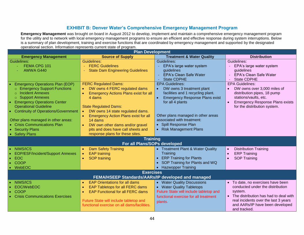
44
EXHIBIT B: Denver Water’s Comprehensive Emergency Management Program
Emergency Management was brought on board in August 2012 to develop, implement and maintain a comprehensive emergency management program for the utility and to network with local emergency management programs to ensure an efficient and effective response during system interruptions. Below is a summary of plan development, training and exercise functions that are coordinated by emergency management and supported by the designated operational section. Information represents current state of program.
Plan Development Emergency Management Source of Supply Treatment & Water Quality Distribution
Guidelines:
- FEMA CPG 101 - AWWA G440
Guidelines:
- FERC Guidelines - State Dam Engineering Guidelines
Guidelines:
- EPA’s large water system guidelines
- EPA’s Clean Safe Water - State CDPHE
Guidelines:
- EPA’s large water system guidelines
- EPA’s Clean Safe Water - State CDPHE
Emergency Operations Plan (EOP) o Emergency Support Functions o Incident Annexes o Support Annexes
Emergency Operations Center Operational Guideline
Continuity of Operations/Government Other plans managed in other areas:
Crisis Communications Plan
Security Plans
Safety Plans
FERC Regulated Dams:
DW owns 4 FERC regulated dams
Emergency Actions Plans exist for all 4 dams
State Regulated Dams:
DW owns 14 state regulated dams.
Emergency Action Plans exist for all 14 dams
DW own other dams and/or gravel pits and does have call sheets and response plans for these sites.
EPA Guidelines:
DW owns 3 treatment plant facilities and 1 recycling plant.
Emergency Response Plans exist for all 4 plants
Other plans managed in other areas associated with treatment:
Spill Response Plan
Risk Management Plans
EPA Guidelines:
DW owns over 3,000 miles of distribution pipes, 18 pump stations/vaults, etc.
Emergency Response Plans exists for the distribution system.
Training For all Plans/SOPs developed
NIMS/ICS
EOP/ESF/Incident/Support Annexes
EOC
COOP
WebEOC
Dam Safety Training
EAP training
SOP training
Treatment Plant & Water Quality Training
ERP Training for Plants
SOP Training for Plants and WQ
Hazwopper Training
Distribution Training
ERP Training
SOP Training
Exercises FEMA/HSEEP Standards/AARs/IP developed and managed
NIMS/ICS
EOC/WebEOC
COOP
Crisis Communications Exercises
EAP Orientations for all dams
EAP Tabletops for all FERC dams
EAP Functional for all FERC dams Future State will include tabletop and functional exercise on all dams/facilities.
Water Quality Discussions
Water Quality Tabletops Future State will include tabletop and
functional exercise for all treatment
plants.
To date, no exercises have been conducted under the distribution system.
The distribution has had to deal with real incidents over the last 3 years and AARs/IP have been developed and tracked.
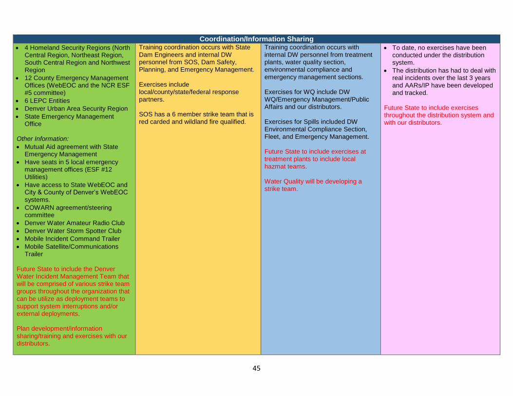
45
Coordination/Information Sharing
4 Homeland Security Regions (North Central Region, Northeast Region, South Central Region and Northwest Region
12 County Emergency Management Offices (WebEOC and the NCR ESF #5 committee)
6 LEPC Entities
Denver Urban Area Security Region
State Emergency Management Office
Other Information:
Mutual Aid agreement with State Emergency Management
Have seats in 5 local emergency management offices (ESF #12 Utilities)
Have access to State WebEOC and City & County of Denver’s WebEOC systems.
COWARN agreement/steering committee
Denver Water Amateur Radio Club
Denver Water Storm Spotter Club
Mobile Incident Command Trailer
Mobile Satellite/Communications Trailer
Future State to include the Denver Water Incident Management Team that will be comprised of various strike team groups throughout the organization that can be utilize as deployment teams to support system interruptions and/or external deployments. Plan development/information sharing/training and exercises with our distributors.
Training coordination occurs with State Dam Engineers and internal DW personnel from SOS, Dam Safety, Planning, and Emergency Management. Exercises include local/county/state/federal response partners. SOS has a 6 member strike team that is red carded and wildland fire qualified.
Training coordination occurs with internal DW personnel from treatment plants, water quality section, environmental compliance and emergency management sections. Exercises for WQ include DW WQ/Emergency Management/Public Affairs and our distributors. Exercises for Spills included DW Environmental Compliance Section, Fleet, and Emergency Management. Future State to include exercises at treatment plants to include local hazmat teams. Water Quality will be developing a strike team.
To date, no exercises have been conducted under the distribution system.
The distribution has had to deal with real incidents over the last 3 years and AARs/IP have been developed and tracked.
Future State to include exercises throughout the distribution system and with our distributors.
46
47
EXHIBIT C: Detailed Description of Public Meetings
Onsite Wastewater Treatment Systems (OWTS) Date: Friday, December 14, 2013 Location: Deckers Community Center, Deckers, CO Presenters: David Kurz, CDPHE; Kate Carney, Church OWTS Consultants; Tim Galvin, Underground Solutions. Related links to presentations: http://cusp.ws/wp-content/uploads/2014/10/OWTS-Source-Water-Protection-12-13-13.pdf Vast areas of the Upper South Platte River service area are rural or remote and with residential septic systems rather than community/city sewer. The regions with community sewer are mainly located in the more densely populated northeastern region of the watershed. It is important to address contaminants of concern including discharges, failing septic systems, and residual contaminants from OWTS that potentially may impact local water quality. Using targeted online/survey education tools, develop effective septic system awareness to inform landowners and realtors of BMPs and potential opportunities
Develop a website to educate DW customers on a range of source water issues
including OWTS
o Online Public Meeting to get information out to consumers and direct them
to:
Survey links
Rebates and incentives
o Quick kits for testing
o Provide information to the real estate industry regarding regulations
related to
Transfer of Title requirements
Inspections
Pumping
Repairs at time of sale
Door knocking
Flyers (send information with water and/or tax bills)
Review Practitioner Certification Standards:
Research, review, and store the OWTS regulation that each county adopted.
Identify the county representative(s) that handle septic system issues and
establish a line of communication for future developments that may impact water
quality.
Coordinate GIS overlays and mapping and identify sensitive areas:
Research best layer for approximating septic system density (currently using well
information)
o Septic system density
48
o Soil treatment areas (leach fields)
Contact Park County Administrator (Tom Eisenman) for USGS septic system
study
Define and map sensitive drinking water areas
o Proximity to stream(s) (1000 foot buffer)
o Soil type(s)
o Density of systems
o Age of development(s)
In sensitive areas, perform surface water monitoring for nutrients and other potential hazards
Pick sample points
Monitor for nutrients and emerging contaminants (and tracers such as caffeine
and endocrine disrupters – re Sarah: Water Research Foundation study)
Collect and analyze data
Determine if data shows degradation due to septic systems
Dye testing
Agricultural impacts
Uranium
Abandoned mine drainage/effluent
Research potential for septic inspections/record submittals on property transfers (sensitive areas only) Examine new County regulations for all four counties, adopted June 30, 2014, regarding inspections at transfer of title, whether old systems get grandfathered in, whether installers are certified, if effluent filters are required, setbacks from water bodies and drinking water wells, whether land disposal of pumped waste is allowed, etc.
Check with counties for current practices (Boulder County is a good example)
Check with Tri-Lakes
If not in effect, recommend that counties incorporate inspections at time of
transfer (only for sensitive areas?)
Work with Counties to provide safe pumped sludge storage/disposal
Agricultural Practices and Issues Date: Friday, February 14, 2014 Location: Deckers Community Center, Deckers, CO Presenters: Ben Berlinger, NRCS; John Woodward, CCA; Steve Ryder, CO Dept. of Ag Related links to presentations: http://cusp.ws/wp-content/uploads/2014/10/Small-Acreage-Management-for-Horse-Owners_Boulder-Valley-Conservation-District.pdf; http://www.cusp.ws/wp-content/uploads/2014/10/Water Quality J Woodward.pdf; http://www.cusp.ws/wp-
49
content/uploads/2014/10/CUSP_Feb2014.pdf; http://cusp.ws/wp-content/uploads/2014/10/Principles-of-Controlled-Grazing_University-of-CA-at-Davis.pdf; http://cusp.ws/wp-content/uploads/2014/10/CUSP_Grazing-Principles__2-14-2014.pdf Ranching is a rich part of the history of the Upper South Platte Watershed as well as a vibrant industry in the region today. From large-scale ranching operations to small hobby farms, ranching thrives in the western portions of the watershed. Strong and active associations and organizations help ranchers understand state-of–the-art ranching techniques and best management practices. Programs offered through the USDA NRCS also provide outstanding resources and funding opportunities for the ranching communities. There is still much to be done to ensure consistent BMPs that preserve and protect the resources impacted by agricultural activities.
Draft standardized language and policies for grazing contracts/MOUs
between large landowners, land use managers and ranchers
Research USDA, Department of Ag, Cattlemen’s Association, Colorado State
Extension, etc., to assist in language development
Draft a proposed example contract containing sample language
Distribute document to partners and refine it as needed
Develop a stakeholder based approach to engage the entities in using the new
template (please explain)
Outreach, education, and marketing of new template – implementation
Check with CALF – Colorado Agricultural Leadership Foundation
Spatial identification and analysis of sensitive drinking water areas adjacent to, and downstream of, agricultural operations
Gather GIS data indicating land use for agricultural purposes
Define sensitive drinking water areas
o Proximity to stream (1000 foot buffer)
o Soil type
o Density of operations
Encourage use of
o Riparian buffers
o Hardened Water sites
o Fenced buffers
o Potential augmentation water for off channel livestock watering
Using targeted education tools and working with an intern, develop effective agricultural practices materials/awareness to inform/educate landowners and real estate industry
Identify/generate “Rural Realities/Lifestyle” resources e.g. http://www.extension.colostate.edu/gilpin/natu/natu_docs/Mountain Livestock
50
Brochure-GilpinNew reviewed.pdf ; http://www.co.teller.co.us/communications/rural.htm
Identify grazing related county regulations
Subdivision grazing fence-out
Hobby Ranching
Coordinate with Colorado State University (CSU) Extension Services and inform
them of sensitive areas
Coordinate with NRCS (and Conservation Districts)
Through partners
o Develop a website to educate
o Door knocking
o Flyers
o Rebates
Identify and promote funding opportunities for landowners to improve agricultural practices (such as fencing to keep cattle out of riparian areas, hardened water crossings, rotational grazing, etc.)
Create a list of funding sources for agricultural practices and BMP’s
Research ways to implement off-channel livestock watering practices
(augmentation?)
Determine best outreach organization and coordinate with them (probably not
Denver Water)
(NRCS, Colorado Cattleman’s association, USDA, USFS, BLM) Research Conservation easements (tax implications) Cattleman’s Land Trust easement Palmer Land Trust Mountain Area Trust Colorado Open Lands CALF (Colorado Agricultural Leadership Foundation)
51
Oil and Gas Exploration and Extraction Issues (Two Part) Part One Date: Friday, March 14, 2014 Location: Fairplay Community Center, Fairplay CO Presenters: Peter Milonas, State Land Board; John Dow, USFS; Keith Berger, BLM; Jerry Strahan, BLM Related links to presentations: http://cusp.ws/wp-content/uploads/2014/10/South-Park-BMP-Presentation.pdf; http://www.cusp.ws/wp-content/uploads/2014/10/CUSP 2011 Groundwater and Surface Water Baseline Monitoring Project.pdf Part Two Date: Friday, April 11, 2014 Location: Fairplay Community Center, Fairplay CO Presenters: Andrew Casper, COGA; Tom Eisenman, Park County Related links to presentations: http://cusp.ws/wp-content/uploads/2014/10/OG-Meeting-COGA-presentation.pdf; http://cusp.ws/wp-content/uploads/2014/10/South-Park-Groundwater-Quality-Scoping-Study_Final.pdf Oil and gas resource exploration and extraction in Colorado has been taking place since the mid-twentieth century. The majority of active extraction currently occurs in the northern part of the state, but areas within the Upper South Platte watershed have been identified as viable sources for exploration. This is a complex and potentially controversial issue. It can be complicated further by matters of surface land ownership vs. mineral rights and the vast areas of land involved in horizontal and vertical drilling. It is also important to understand the many ways in which water can be impacted ranging from the intensive use of water for resource extraction as well as the impacts to the quality of the water once it is recycled. The Colorado Oil and Gas Conservation Commission, a division of the Colorado Department of Natural Resources is the agency that interfaces with the Colorado Oil and Gas Association and the industry in regulatory and compliance issues. Participate in, and help define setbacks, drilling stipulations, BMP approaches, etc. to be included in the BLM Master Leasing Plan process and the PSICC Forest Service Oil and Gas Leasing process
Provide GIS layers
Attend planning meetings
Work with key agencies in BLM Master Leasing Plan process (Royal Gorge BLM, RMP, Pike Isabel Oil and Gas Leasing Plan)
o BLM (Statewide draft water stipulations for surface protection, NSO Municipal wells, etc. – get copies)
o Park County (has regulations related to oil and gas development) o Colorado Department of Public Health and Environment (CDPHE) o COGA o COGCC o USFS
Determine and define setbacks/perimeters/buffers around reservoirs, perennial rivers, wells, diversion points, and other sensitive areas (GIS component) for well drilling
Apply lessons learned to other Denver Water watersheds Work with other counties to raise awareness of BMPs for oil and gas drilling
52
Identify environmentally sensitive areas for all of Upper South Platte watershed
Contact local designee for each county, establish a relationship with them and inform them of recommendation of BLM master leasing program
Monitor oil and gas leasing on Denver Water properties
Check COGCC permit application information
Connect with COGCC
Form working relationships with State Land Bard personnel
Provide guidance on suggested BMPs to local designee
Research what counties have 1031 jurisdiction being implemented. Transportation (Two Part)
Part One: Roads Date: Friday, May 9, 2014 Location: Fairplay Community Center, Fairplay, CO Presenters, Kyle Hamilton, CH2M Hill; Holly Huyuk, CDOT Related links to presentations: http://cusp.ws/wp-content/uploads/2014/10/CUSPDenverWaterWaPlan-RdsandTrls.pdf; http://cusp.ws/wp-content/uploads/2014/10/CDOT-SedandSpillCtrl4CUSP.pdf Part Two: Emergency Response Date: Friday, June 13, 2014 Location: Deckers Community Center, Deckers, CO Presenters: Andy Flukey, CDOT; Sheila Cross, Park County; Garth Englund, Douglas County ROADS: Multi-modal transportation corridors in the Upper South Platte Watershed range from social trails established over decades of recreational use to well-traveled State highways. The four State highways (285, 24, 67 and 9) that crisscross the watershed carry residents, commuters, tourists and commercial users throughout the watershed, also connecting them to major metropolitan and recreational destinations. Identify sensitive areas and potentially hazardous activities occurring in proximity to these areas
Review previous WARSSS and/or similar assessments for priorities and focus areas
Combine and assess existing info o Erodability o Slope o Wildfire risk assessment has some information
GIS/mapping of roads etc., in relation to drinking water infrastructure
Form a committee of experts to discuss this issue and assess priority areas
Ground truth where roads are contributing to sediment in surface water
Additional monitoring
Identify who owns roads, who maintains (USFS, BLM, County, private)
Establish connections for weed spraying activities, share the sensitive areas near streams with them.
Identify maintenance entities that work in sensitive areas
Counties
53
Review county(s) BMPs – consolidate for road maintenance education at all levels (including targeted subdivisions/private ownership)
o Integrate BMP training into existing annual organizational internal training events o Attend appropriate staff meetings for educational purposes
Coordinate with CH2M Hill and organizations that deal with grading roads to do coordinated outreach (and training of operators)
Identify current/existing projects that employ BMPs to use as project example/review sites for county maintenance crews – possibly develop a video tour or workshops
Create “cheat sheet”/card for road maintenance operators
Signage for blade operators: e.g., tilt left here
Speakers’ Circuit – (APWA local annual conference presentation)
Provide road training for Denver Water operators Review USFS Road Construction Best Management Practices and integrate where appropriate (See appendix). EMERGENCY RESPONSE: Effective emergency spill responses depend on excellent communications and quick actions by a relatively few individuals, including emergency responders and water supply managers. Maintaining adequate water supply during floods, forest fires, windstorms, or manmade disasters is a matter of good planning to protect water supplies and power to operate treatment and supply facilities. Roads and highways can contaminate water sources through spills, creation of airborne contaminates which eventually distill into the watershed, through road treatments including salts, sands, and other chemicals for snow and ice, siltation, and fuels, oils, and other contaminates carried by vehicles and released slowly onto roads and highways. Rapid and coordinated response and communication during all phases of Emergency Response is critical for the health and safety of area residents and their water supply. Education/Outreach to ALL emergency responders/dispatchers to help them understand the potential impacts to all of their constituents/communities/drinking water
Create/Provide laminated info card with o Hotline Info-1-877-518-5608 – is manned 24/7 – o Sensitive areas/Map o Provide Hot Line number to ALL emergency responders, public water system
staff/managers, and dispatchers (Sheriffs’ Offices, Police Departments, Colorado State Police, etc.)
Dashboard stickers with Hotline info Encourage development of hazard waste dumping/recycling program in counties.
Reach out to counties to see if they have an existing program
Research ways and funding opportunities to develop programs
Identify locations in watershed for recycling centers
Awareness and outreach
Potential focus areas o Prescription take back o Electronic recycle o Habitat for Humanity paint recycling o Pesticides/Herbicides
Spill kits
Do an inventory/analysis of who has what (oil/hazmat) and who is trained to use
54
Consider adding additional spill kits in emergency response vehicles – oil spill kits, hazmat kits (car accidents etc.,)
Raising awareness of sensitive areas
Identify sensitive areas
Determine audience o County workers o General public
Work with CDOT
Signage on side of road (entering USPW signage) FOREST HEALTH Date: Friday, August 8, 2014 Location: Denver Water Three Stones Building, Denver, CO Presenters: Jonathan Bruno, CUSP; Jeff Underhill, USFS; Joseph Hanson, Jeffco CD Related links to presentations: http://cusp.ws/wp-content/uploads/2014/05/SWAP2014.pdf; http://cusp.ws/wp-content/uploads/2014/10/Silviculture_2014.pdf The Upper South Platte Watershed has seen some of Colorado’s most devastating wildfires. The 2002 Hayman Fire burned over 136,000 acres and is still ranks as the largest wildfire in Colorado history. In response to wildfires, many regional agencies and organizations have become expert at not only dealing with post-fire recovery, but in learning the importance of prevention through mitigation. Bringing a heavily forested watershed into a state of balanced vigor demands an ongoing and proactive approach to forestland management. From research to implementation, it is important to recognize and understand, emerging, state-of-the-art and innovative mitigation and treatment technologies. It is essential that Denver Water continue its vital leadership role in collaborative and cooperative planning and implementation processes such as the Front Range Roundtable that address these issues.
Define/map setbacks and firebreaks for critical infrastructure and resources including
Up-to-date risk assessments for critical areas o Review existing assessments for gaps
Drinking water reservoirs
Water treatment facilities
Key diversions
Make sure these areas are accessible to emergency responders
Work with USFS to define the actual setbacks and what is the best indication – what are the patterns - coordinate on the USFS – FS needs to know where actual infrastructure is located
Preventative strategies - layers to share
Make the layers to the cooperating agencies
How do we best share this info – pre fire meetings
Emergency response
Identify key responders
Develop protocols for rapid response
Provide maps of critical infrastructure
Coordinate with Denver Water Emergency Response team - Sarah
Funding Resources – Run By Don Kennedy – coordinate with internal resources
55
Identify potential project areas/timeline (long-range to “low hanging fruit”) o Identify appropriate project/program partners o Identify/list project needs o Develop per project budgets
Identify potential funding sources o Governmental/Foundations o Calendar of availability/deadlines o Table of requirements/eligibility
Match In-kind
Public Education
Identify programs for public/property owner programs
Educate re: o Prescribed burns o Combo treatments o Related legislation/mandates
Continue to Participate in research related to
Fire impacts -
Mitigation o Identify who is doing research and where it is being done o Identify and map areas with CWPPs
URANIUM AND MINE DRAINAGES Date: Friday, November 14, 2014 Location: Deckers Community Center, Deckers, CO Presenters: Jara Johnson, CUSP Related links to presentation: http://cusp.ws/wp-content/uploads/2014/05/CO_DMG_BMPs_AML_Reclamation.pdf; http://cusp.ws/wp-content/uploads/2014/05/UraniumFactSheetCGS1.pdf; http://cusp.ws/wp-content/uploads/2014/05/Mining-in-USPW.pdf Colorado’s history is, in large part, built on mining. The promise of wealth from mining brought many people to the area in the mid- 1800’s and for decades was a major economic driver within the state. Mineral mining still thrives in the state and impacts related to past and abandoned mining activities still pose issues throughout the watershed. Uranium was first discovered in the U.S. in Colorado. While the highest concentration of active uranium projects are in the southwest region of the state, there is a long history of uranium mining in Park County. Since this is a heavily regulated and monitored industry, it is important to be aware of updates to related regulations, stipulations and laws. Research and partner with groups and agencies already working on abandoned mine issues – coordinate efforts
Abandoned mine team o USFS, USFWS, DRMS, CDPHE, EPA, CUSP, Local counties
Work with BLM o Establish and draft a cooperative agency agreement o Update Resource Management Plan as applicable
Master Leasing Plan
Permitting, monitoring and tracking
56
Develop a process for monitoring and tracking o Internal Denver Water tracking process
Who gets notified for which permitting and or monitoring processes Counties are notified, therefore they may be the best contact DRMS
needs to notify before rather than after County agencies - DW, Counties and DRMS to set up a better chain of
communication – set-up flow chart of information. Get DW on communication list
Identify existing monitoring programs
Review permits being requested for deep drilling re impacts to uranium beds
Consistently define setbacks from water sources and critical infrastructure for all related industries (oil & gas, uranium).
Require coordination with DW re operations and response
Final draft from O&G leasing meetings and the county has 500 ft from all streams in Park co – agreed to have set backs – what should they be?
Review Master Leasing Plan recommendations and formulate a strategy
Mapping exercise via MLP– keep document for potential issues – look at 2 prop – take piece from MLP to use a place to start – keep the language and coordinate with Park County (T. Eisenman)
Local designee – coordinate on 2A process with COGCC –
Jefferson & Douglas county – local designee
Table of local designee – contact list for the COGCC process – counties, CDPHE – Intern
HYDRO-GEOMORPHIC ISSUES Date: Friday, December 12, 2014 Location: Denver Water Three Stones Building, Denver, CO Presenter: Peter Gallagher, Fin-Up Because water is one of the most important agents in forming and shaping of landforms, Hydrogeomorphology can been defined as an interdisciplinary science that focuses on the interaction and linkage of hydrologic processes with landforms or earth materials and the interaction of geomorphic processes with surface and subsurface water in temporal and spatial dimensions. With this understanding, Hydrogeomorphology is not a singular issue, but rather an inclusive one that impacts most areas of plan development when considering BMPs.
Identify and map existing WARSSS and/or similar type studies/plans/reports/analysis within the watershed
o Implement rapid assessment in areas with no data
Get involved and participate in Basin Implementation Plans – How do they tie to WARSSS and other assessments – Look at quantity/quality relationship Is funding is going the engaged roundtables?
Identify high priority projects o Identify partners o Identify funding sources as needed
57
GIS/MAPPING Date: Friday, April 10, 2015 Location: Denver Water, Board Room, Denver, CO Presenters: Diego Portillo, Denver Water; Carrie Adair, CUSP GIS and mapping are the tools that tie the plan together. They provide the picture of where source water points exist in the watershed as well as the proximity of activity to those points. Effectively using GIS, layering, overlays and mapping can be a complex process and requires cooperation from many stakeholders. Hosting the dense amounts of information needed to create functional products is a challenge that requires identifying both needs and products as well as existing information and gaps in needed information.
Identify each plan area that requires GIS, layers and mapping components
Identify audience(s). This will inform what layers are needed o Internal use
Potentially more complex product o Potentially small fire districts, water providers o Public use
Potentially a story map o Create a simple map and track usage and patterns
Use this info to improve/modify/expand
Identify the type(s) of functionality required o ArcGIS
Identify applications/data/systems hosting options o Secured/unsecured (data security criteria) o Develop a list of what data is shared with stakeholders vs. public
Secured for identified stakeholders Unsecured for public access
o ESRI
Data gaps analysis for required lays for the plan o Identify what entities will have the information, e.g.,
Counties USFS DW BLM, etc.
Analyze value/benefits of more resource-intensive GIS tool
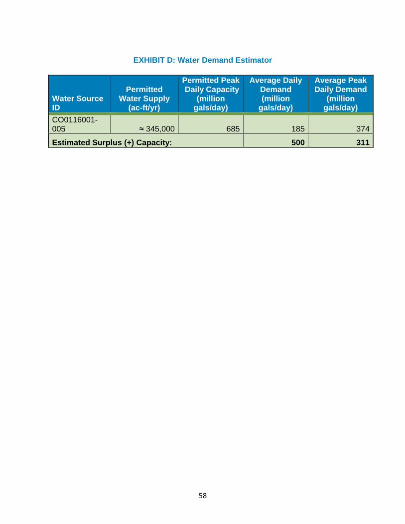
58
EXHIBIT D: Water Demand Estimator
Water Source ID
Permitted Water Supply
(ac-ft/yr)
Permitted Peak Daily Capacity
(million gals/day)
Average Daily Demand (million
gals/day)
Average Peak Daily Demand
(million gals/day)
CO0116001-005 ≈ 345,000 685 185 374
Estimated Surplus (+) Capacity: 500 311
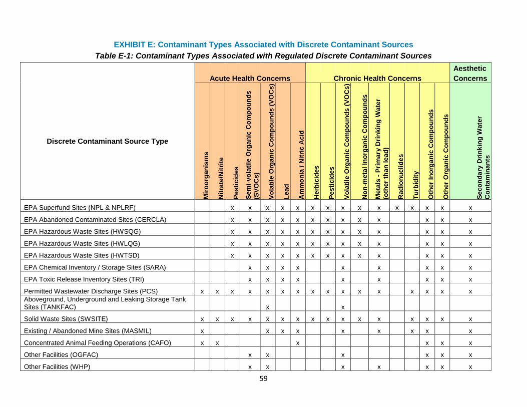
59
EXHIBIT E: Contaminant Types Associated with Discrete Contaminant Sources
Table E-1: Contaminant Types Associated with Regulated Discrete Contaminant Sources
Aesthetic
Acute Health Concerns Chronic Health Concerns Concerns
Discrete Contaminant Source Type
Mir
oo
rgan
ism
s
Nit
rate
/Nit
rite
Pesti
cid
es
Sem
i-vo
lati
le O
rgan
ic C
om
po
un
ds
(SV
OC
s)
Vo
lati
le O
rgan
ic C
om
po
un
ds (
VO
Cs)
Lead
Am
mo
nia
/ N
itri
c A
cid
Herb
icid
es
Pesti
cid
es
Vo
lati
le O
rgan
ic C
om
po
un
ds (
VO
Cs)
No
n-m
eta
l In
org
an
ic C
om
po
un
ds
Meta
ls -
Pri
mary
Dri
nkin
g W
ate
r
(oth
er
than
lead
)
Rad
ion
uclid
es
Tu
rbid
ity
Oth
er
Ino
rgan
ic C
om
po
un
ds
Oth
er
Org
an
ic C
om
po
un
ds
Seco
nd
ary
Dri
nkin
g W
ate
r
Co
nta
min
an
ts
EPA Superfund Sites (NPL & NPLRF) x x x x x x x x x x x x x x x
EPA Abandoned Contaminated Sites (CERCLA) x x x x x x x x x x x x x
EPA Hazardous Waste Sites (HWSQG) x x x x x x x x x x x x x
EPA Hazardous Waste Sites (HWLQG) x x x x x x x x x x x x x
EPA Hazardous Waste Sites (HWTSD) x x x x x x x x x x x x x
EPA Chemical Inventory / Storage Sites (SARA) x x x x x x x x x
EPA Toxic Release Inventory Sites (TRI) x x x x x x x x x
Permitted Wastewater Discharge Sites (PCS) x x x x x x x x x x x x x x x x
Aboveground, Underground and Leaking Storage Tank Sites (TANKFAC) x x
Solid Waste Sites (SWSITE) x x x x x x x x x x x x x x x x
Existing / Abandoned Mine Sites (MASMIL) x x x x x x x x x
Concentrated Animal Feeding Operations (CAFO) x x x x x x
Other Facilities (OGFAC) x x x x x x
Other Facilities (WHP) x x x x x x x
60
Table E-2: Contaminant Types Associated with Contaminant Types Associated With SIC-Related Discrete Contaminant Sources
Aesthetic
Acute Health Concerns Chronic Health Concerns Concerns
SIC Code
Discrete Contaminant Source Type
Mir
oo
rgan
ism
s
Nit
rate
/Nit
rite
Pesti
cid
es
Sem
i-vo
lati
le O
rgan
ic C
om
po
un
ds
(SV
OC
s)
Vo
lati
le O
rgan
ic C
om
po
un
ds (
VO
Cs)
Lead
Am
mo
nia
/ N
itri
c A
cid
Herb
icid
es
Pesti
cid
es
Vo
lati
le O
rgan
ic C
om
po
un
ds (
VO
Cs)
No
n-m
eta
l In
org
an
ic C
om
po
un
ds
Meta
ls -
Pri
mary
Dri
nkin
g W
ate
r
(oth
er
than
lead
)
Rad
ion
uclid
es
Tu
rbid
ity
Oth
er
Ino
rgan
ic C
om
po
un
ds
Oth
er
Org
an
ic C
om
po
un
ds
Seco
nd
ary
Dri
nkin
g W
ate
r
Co
nta
min
an
ts
021101 LIVESTOCK FEEDING x x x x x x
072103 AERIAL APPLICATORS x x x x x x
075205 DOG & CAT KENNELS x x x x x
075211 PET BOARDING x x x x x
078206
LAWN & GROUNDS MAINTENANCE x x x x x x
078212
SEEDING & FERTILIZING CONTRACTORS x x x x x x
138905 OIL FIELD SERVICE x x x x x x x x x
149901 MINING COMPANIES x x x x x x x x
161106
ASPHALT & ASPHALT PRODUCTS x x x x x x x x
61
171107
SEPTIC TANKS/SYSTEMS-CLEANING/REPAIRING x x x x x
208201 BREWERS x x x x x
208401 WINERIES x x x x x
239698
AUTOMOTIVE TRIMMING/APPRL FINDINGS (MFR) x x x x x x x x
243102 MILLWORK (MANUFACTURERS) x x x x x x x
245201
LOG CABINS HOMES & BUILDINGS (MFRS) x x x x x x x x x
259901 FURNITURE-MANUFACTURERS x x x x x x x x
271101 NEWSPAPERS (PUBLISHERS) x x x x x x x
272102 PUBLISHERS-PERIODICAL x x x x x x x
273101 PUBLISHERS-BOOK x x x x x x x
274119
MULTIMEDIA (MANUFACTURERS) x x x x x x x
275202 PRINTERS x x x x x x x x x x
275203 POSTERS (MANUFACTURERS) x x x x x x x
275902 SCREEN PRINTING x x x x x x x
279601
ENGRAVERS-PLASTIC WOOD & ETC x x x x x x
308901 MOLD MAKERS x x x x x x x x x
308906
PLASTICS-FABRICATING/FINISH/DECOR-MFRS x x x x x x x x x x
62
311101 TANNERS (MANUFACTURERS) x x x x x x
327209
CONCRETE PRODS-EX BLOCK & BRICK (MFRS) x x x x x x
344106
STEEL-STRUCTURAL (MANUFACTURERS) x x x x x x x x x x
344403 SHEET METAL FABRICATORS x x x x x x x x x x
354405 MOLDS (MANUFACTURERS) x x x x x x x x x
356907
AUTOMATION SYSTEMS & EQUIPMENT-MFRS x x x x x x x x x
357908
COPYING MACHINES & SUPPLIES-MFRS x x x x x x x x x x
359903 MACHINE SHOPS x x x x x x x x x x
366398
RADIO/TV BROADCASTING/COMM EQUIP (MFRS) x x x x x x x x x x
369902
ELECTRIC EQUIPMENT-MANUFACTURERS x x x x x x x x x x
371401
AUTOMOBILE PARTS & SUPPLIES-MFRS x x x x x x x x x
399903 MANUFACTURERS x x x x x x x x x x
401101 RAILROADS x x x x x x x x x x
422101 GRAIN ELEVATORS x x x x x x
422501 STORAGE x x x x x x x x x
422505
WAREHOUSES-MERCHANDISE & SELF STORAGE x
422603
RECREATIONAL VEHICLES-STORAGE x x x x x x
63
458104
AIRCRAFT SERVICING & MAINTENANCE x x x x x x x x x x
458106 AIRPORTS x x x x x x x x x
461201 PIPE LINE COMPANIES x x x x x x x x x
491101 ELECTRIC COMPANIES x x x x x x x x x x x
492501 GAS COMPANIES x x x x x x x x x
494102
WATER & SEWAGE COMPANIES-UTILITY x x x x x x x x x x x x x
495302 GARBAGE COLLECTION x x x x x x x x x x x x x x x
503208
CONCRETE PRODUCTS (WHOLESALE) x x x x x x
503211 SAND & GRAVEL (WHOLESALE) x x x x x x
508520
HYDRAULIC EQUIPMENT & SUPPLIES (WHOL) x x x
508522
INDUSTRIAL EQUIPMENT & SUPPLIES (WHOL) x x x x x
509312
RECYCLING CENTERS (WHOLESALE) x x x x x x x
517203 DIESEL FUEL (WHOLESALE) x x x
517208
GAS-LIQUEFIED PETRO-BTTLD/BULK (WHOL) x
517210 GASOLINE & OIL-WHOLESALE x x x
519114 FERTILIZERS (WHOLESALE) x x x x x
519803 PAINT-WHOLESALE x x x x
52112 CONCRETE-READY MIXED x x x x x x
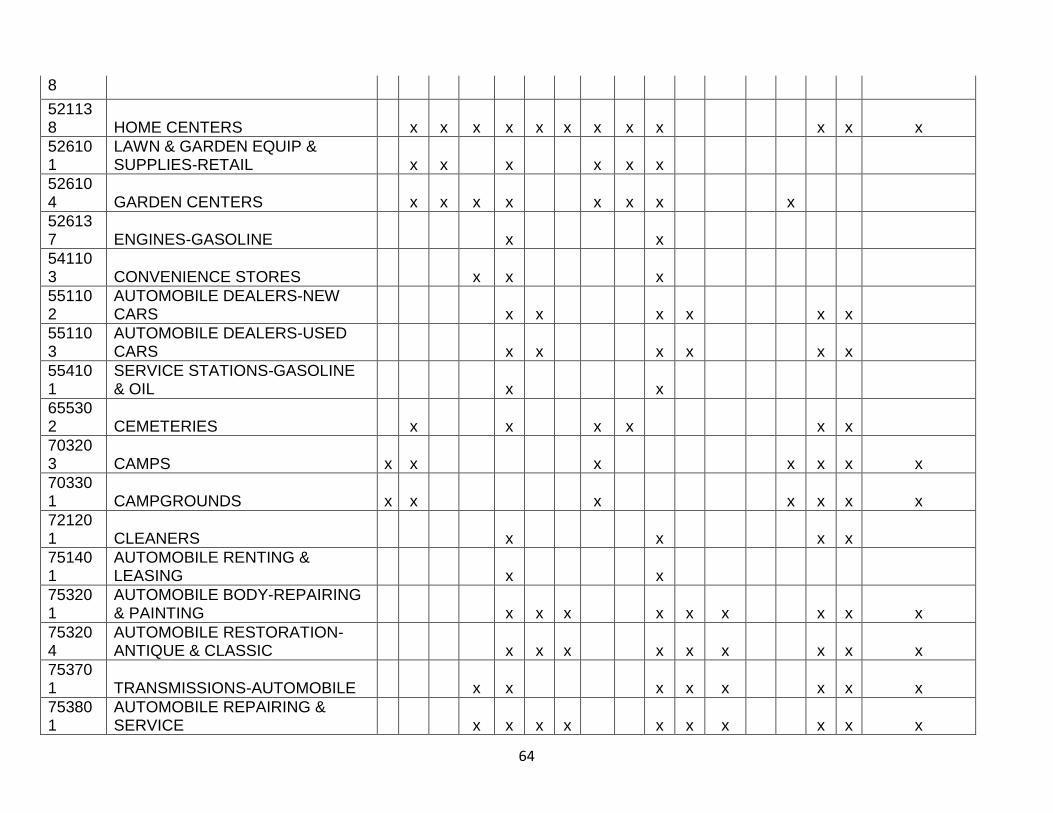
64
8
521138 HOME CENTERS x x x x x x x x x x x x
526101
LAWN & GARDEN EQUIP & SUPPLIES-RETAIL x x x x x x
526104 GARDEN CENTERS x x x x x x x x
526137 ENGINES-GASOLINE x x
541103 CONVENIENCE STORES x x x
551102
AUTOMOBILE DEALERS-NEW CARS x x x x x x
551103
AUTOMOBILE DEALERS-USED CARS x x x x x x
554101
SERVICE STATIONS-GASOLINE & OIL x x
655302 CEMETERIES x x x x x x
703203 CAMPS x x x x x x x
703301 CAMPGROUNDS x x x x x x x
721201 CLEANERS x x x x
751401
AUTOMOBILE RENTING & LEASING x x
753201
AUTOMOBILE BODY-REPAIRING & PAINTING x x x x x x x x x
753204
AUTOMOBILE RESTORATION-ANTIQUE & CLASSIC x x x x x x x x x
753701 TRANSMISSIONS-AUTOMOBILE x x x x x x x x
753801
AUTOMOBILE REPAIRING & SERVICE x x x x x x x x x x
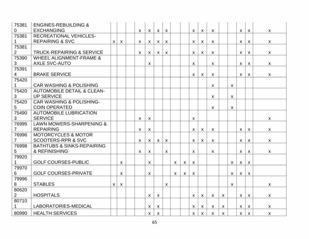
65
753810
ENGINES-REBUILDING & EXCHANGING x x x x x x x x x x
753811
RECREATIONAL VEHICLES-REPAIRING & SVC x x x x x x x x x x x x
753812 TRUCK-REPAIRING & SERVICE x x x x x x x x x x
753903
WHEEL ALIGNMENT-FRAME & AXLE SVC-AUTO x x x x x x
753914 BRAKE SERVICE x x x x x x
754201 CAR WASHING & POLISHING x x
754203
AUTOMOBILE DETAIL & CLEAN-UP SERVICE x x
754205
CAR WASHING & POLISHING-COIN OPERATED x x
754903
AUTOMOBILE LUBRICATION SERVICE x x x x
769957
LAWN MOWERS-SHARPENING & REPAIRING x x x x x x x x
769967
MOTORCYCLES & MOTOR SCOOTERS-RPR & SVC x x x x x x x x x x
769985
BATHTUBS & SINKS-REPAIRING & REFINISHING x x x x x x x x
799201 GOLF COURSES-PUBLIC x x x x x x x x
799706 GOLF COURSES-PRIVATE x x x x x x x x
799968 STABLES x x x x x
806202 HOSPITALS x x x x x x x x x
807101 LABORATORIES-MEDICAL x x x x x x x x x
80990 HEALTH SERVICES x x x x x x x x x
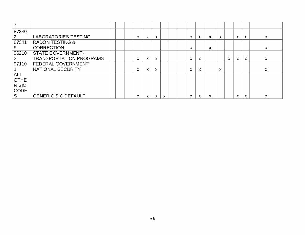
66
7
873402 LABORATORIES-TESTING x x x x x x x x x x
873419
RADON TESTING & CORRECTION x x x
962102
STATE GOVERNMENT-TRANSPORTATION PROGRAMS x x x x x x x x x
971101
FEDERAL GOVERNMENT-NATIONAL SECURITY x x x x x x x
ALL OTHER SIC CODES GENERIC SIC DEFAULT x x x x x x x x x x
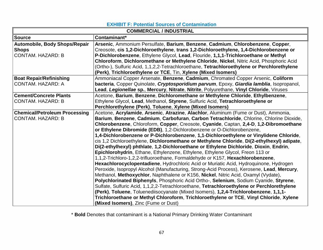
67
EXHIBIT F: Potential Sources of Contamination
COMMERCIAL / INDUSTRIAL
Source Contaminant*
Automobile, Body Shops/Repair Shops CONTAM. HAZARD: B
Arsenic, Ammonium Persulfate, Barium, Benzene, Cadmium, Chlorobenzene, Copper, Creosote, cis 1,2-Dichloroethylene, trans 1,2-Dichloroethylene, 1,4-Dichlorobenzene or P-Dichlorobenzene, Ethylene Glycol, Lead, Flouride, 1,1,1-Trichloroethane or Methyl Chloroform, Dichloromethane or Methylene Chloride, Nickel, Nitric Acid, Phosphoric Acid (Ortho-), Sulfuric Acid, 1,1,2,2-Tetrachloroethane, Tetrachloroethylene or Perchlorethylene (Perk), Trichloroethylene or TCE, Tin, Xylene (Mixed Isomers)
Boat Repair/Refinishing CONTAM. HAZARD: A
Ammoniacal Copper Arsenate, Benzene, Cadmium, Chromated Copper Arsenic, Coliform bacteria, Copper Quinolate, Cryptosporidium parvum, Epoxy, Giardia lamblia, Isopropanol, Lead, Legionellae sp., Mercury, Nitrate, Nitrite, Polyurethane, Vinyl Chloride, Viruses
Cement/Concrete Plants CONTAM. HAZARD: B
Acetone, Barium, Benzene, Dichloromethane or Methylene Chloride, Ethylbenzene, Ethylene Glycol, Lead, Methanol, Styrene, Sulfuric Acid, Tetrachloroethylene or Perchlorethylene (Perk), Toluene, Xylene (Mixed Isomers)
Chemical/Petroleum Processing CONTAM. HAZARD: B
Acetone, Acrylamide, Arsenic, Atrazine, Alachlor, Aluminum (Fume or Dust), Ammonia, Barium, Benzene, Cadmium, Carbofuran, Carbon Tetrachloride, Chlorine, Chlorine Dioxide, Chlorobenzene, Chloroform, Copper, Creosote, Cyanide, Captan, 2,4-D, 1,2-Dibromoethane or Ethylene Dibromide (EDB), 1,2-Dichlorobenzene or O-Dichlorobenzene, 1,4-Dichlorobenzene or P-Dichlorobenzene, 1,1-Dichloroethylene or Vinylidene Chloride, cis 1,2 Dichloroethylene, Dichloromethane or Methylene Chloride, Di(2-ethylhexyl) adipate, Di(2-ethylhexyl) phthlate, 1,2-Dichloroethane or Ethylene Dichloride, Dioxin, Endrin, Epichlorohydrin, Ethane, Ethylenzene, Ethylene, Ethylene Glycol, Freon 113 or 1,1,2-Trichloro-1,2,2-trifluoroethane, Formaldehyde or K157, Hexachlorobenzene, Hexachlorocyclopentadiene, Hydrochloric Acid or Muriatic Acid, Hydroquinone, Hydrogen Peroxide, Isopropyl Alcohol (Manufacturing, Strong-Acid Process), Kerosene, Lead, Mercury, Methanol, Methoxychlor, Naphthalene or K156, Nickel, Nitric Acid, Oxamyl (Vydate), Polychlorinated Biphenyls, Phosphoric Acid Ortho-, Selenium, Sodium Cyanide, Styrene, Sulfate, Sulfuric Acid, 1,1,2,2-Tetrachloroethane, Tetrachloroethylene or Perchlorethylene (Perk), Toluene, Toluenediisocyanate (Mixed Isomers), 1,2,4-Trichlorobenzene, 1,1,1-Trichloroethane or Methyl Chloroform, Trichloroethylene or TCE, Vinyl Chloride, Xylene (Mixed Isomers), Zinc (Fume or Dust)
* Bold Denotes that contaminant is a National Primary Drinking Water Contaminant
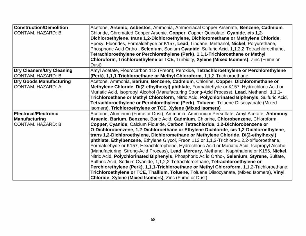
68
Construction/Demolition CONTAM. HAZARD: B
Acetone, Arsenic, Asbestos, Ammonia, Ammoniacal Copper Arsenate, Benzene, Cadmium, Chloride, Chromated Copper Arsenic, Copper, Copper Quinolate, Cyanide, cis 1,2-Dichloroethylene, trans 1,2-Dichloroethylene, Dichloromethane or Methylene Chloride, Epoxy, Fluorides, Formaldehyde or K157, Lead, Lindane, Methanol, Nickel, Polyurethane, Phosphoric Acid Ortho-, Selenium, Sodium Cyanide, Sulfuric Acid, 1,1,2,2-Tetrachloroethane, Tetrachloroethylene or Perchlorethylene (Perk), 1,1,1-Trichloroethane or Methyl Chloroform, Trichloroethylene or TCE, Turbidity, Xylene (Mixed Isomers), Zinc (Fume or Dust)
Dry Cleaners/Dry Cleaning CONTAM. HAZARD: B
Amyl Acetate, Flourocarbon 113 (Freon), Peroxide, Tetrachloroethylene or Perchlorethylene (Perk), 1,1,1-Trichloroethane or Methyl Chloroform, 1,1,2-Trichloroethane
Dry Goods Manufacturing CONTAM. HAZARD: A
Acetone, Ammonia, Barium, Benzene, Cadmium, Chlorine, Copper, Dichloromethane or Methylene Chloride, Di(2-ethylhexyl) phthlate, Formaldehyde or K157, Hydrochloric Acid or Muriatic Acid, Isopropyl Alcohol (Manufacturing Strong-Acid Process), Lead, Methanol, 1,1,1-Trichloroethane or Methyl Chloroform, Nitric Acid, Polychlorinated Biphenyls, Sulfuric Acid, Tetrachloroethylene or Perchlorethylene (Perk), Toluene, Toluene Diisocyanate (Mixed Isomers), Trichloroethylene or TCE, Xylene (Mixed Isomers)
Electrical/Electronic Manufacturing CONTAM. HAZARD: B
Acetone, Aluminum (Fume or Dust), Ammonia, Ammonium Persulfate, Amyl Acetate, Antimony, Arsenic, Barium, Benzene, Boric Acid, Cadmium, Chlorine, Chlorobenzene, Chloroform, Copper, Cyanide, Calcium Flouride, Carbon Tetrachloride, 1,2-Dichlorobenzene or O-Dichlorobenzene, 1,2-Dichloroethane or Ethylene Dichloride, cis 1,2-Dichloroethylene, trans 1,2-Dichloroethylene, Dichloromethane or Methylene Chloride, Di(2-ethylhexyl) phthlate, Ethylbenzene, Ethylene Glycol, Freon 113 or 1,1,2-Trichloro-1,2,2-trifluoroethane, Formaldehyde or K157, Hexachlorophene, Hydrochloric Acid or Muriatic Acid, Isopropyl Alcohol (Manufacturing, Strong-Acid Process), Lead, Mercury, Methanol, Naphthalene or K156, Nickel, Nitric Acid, Polychlorinated Biphenyls, Phosphoric Ac id Ortho-, Selenium, Styrene, Sulfate, Sulfuric Acid, Sodium Cyanide, 1,1,2,2-Tetrachloroethane, Tetrachloroethylene or Perchlorethylene (Perk), 1,1,1-Trichloroethane or Methyl Chloroform, 1,1,2-Trichloroethane, Trichloroethylene or TCE, Thallium, Toluene, Toluene Diisocyanate, (Mixed Isomers), Vinyl Chloride, Xylene (Mixed Isomers), Zinc (Fume or Dust)
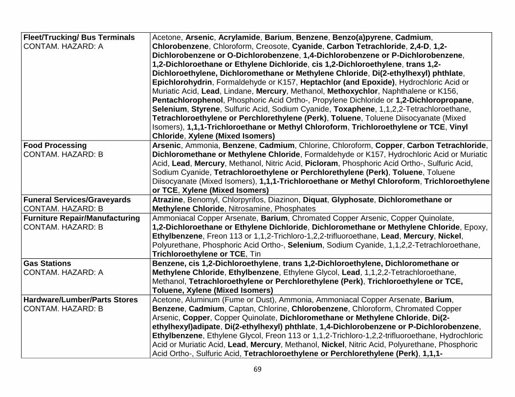
69
Fleet/Trucking/ Bus Terminals CONTAM. HAZARD: A
Acetone, Arsenic, Acrylamide, Barium, Benzene, Benzo(a)pyrene, Cadmium, Chlorobenzene, Chloroform, Creosote, Cyanide, Carbon Tetrachloride, 2,4-D, 1,2-Dichlorobenzene or O-Dichlorobenzene, 1,4-Dichlorobenzene or P-Dichlorobenzene, 1,2-Dichloroethane or Ethylene Dichloride, cis 1,2-Dichloroethylene, trans 1,2-Dichloroethylene, Dichloromethane or Methylene Chloride, Di(2-ethylhexyl) phthlate, Epichlorohydrin, Formaldehyde or K157, Heptachlor (and Epoxide), Hydrochloric Acid or Muriatic Acid, Lead, Lindane, Mercury, Methanol, Methoxychlor, Naphthalene or K156, Pentachlorophenol, Phosphoric Acid Ortho-, Propylene Dichloride or 1,2-Dichloropropane, Selenium, Styrene, Sulfuric Acid, Sodium Cyanide, Toxaphene, 1,1,2,2-Tetrachloroethane, Tetrachloroethylene or Perchlorethylene (Perk), Toluene, Toluene Diisocyanate (Mixed Isomers), 1,1,1-Trichloroethane or Methyl Chloroform, Trichloroethylene or TCE, Vinyl Chloride, Xylene (Mixed Isomers)
Food Processing CONTAM. HAZARD: B
Arsenic, Ammonia, Benzene, Cadmium, Chlorine, Chloroform, Copper, Carbon Tetrachloride, Dichloromethane or Methylene Chloride, Formaldehyde or K157, Hydrochloric Acid or Muriatic Acid, Lead, Mercury, Methanol, Nitric Acid, Picloram, Phosphoric Acid Ortho-, Sulfuric Acid, Sodium Cyanide, Tetrachloroethylene or Perchlorethylene (Perk), Toluene, Toluene Diisocyanate (Mixed Isomers), 1,1,1-Trichloroethane or Methyl Chloroform, Trichloroethylene or TCE, Xylene (Mixed Isomers)
Funeral Services/Graveyards CONTAM. HAZARD: B
Atrazine, Benomyl, Chlorpyrifos, Diazinon, Diquat, Glyphosate, Dichloromethane or Methylene Chloride, Nitrosamine, Phosphates
Furniture Repair/Manufacturing CONTAM. HAZARD: B
Ammoniacal Copper Arsenate, Barium, Chromated Copper Arsenic, Copper Quinolate, 1,2-Dichloroethane or Ethylene Dichloride, Dichloromethane or Methylene Chloride, Epoxy, Ethylbenzene, Freon 113 or 1,1,2-Trichloro-1,2,2-trifluoroethane, Lead, Mercury, Nickel, Polyurethane, Phosphoric Acid Ortho-, Selenium, Sodium Cyanide, 1,1,2,2-Tetrachloroethane, Trichloroethylene or TCE, Tin
Gas Stations CONTAM. HAZARD: A
Benzene, cis 1,2-Dichloroethylene, trans 1,2-Dichloroethylene, Dichloromethane or Methylene Chloride, Ethylbenzene, Ethylene Glycol, Lead, 1,1,2,2-Tetrachloroethane, Methanol, Tetrachloroethylene or Perchlorethylene (Perk), Trichloroethylene or TCE, Toluene, Xylene (Mixed Isomers)
Hardware/Lumber/Parts Stores CONTAM. HAZARD: B
Acetone, Aluminum (Fume or Dust), Ammonia, Ammoniacal Copper Arsenate, Barium, Benzene, Cadmium, Captan, Chlorine, Chlorobenzene, Chloroform, Chromated Copper Arsenic, Copper, Copper Quinolate, Dichloromethane or Methylene Chloride, Di(2-ethylhexyl)adipate, Di(2-ethylhexyl) phthlate, 1,4-Dichlorobenzene or P-Dichlorobenzene, Ethylbenzene, Ethylene Glycol, Freon 113 or 1,1,2-Trichloro-1,2,2-trifluoroethane, Hydrochloric Acid or Muriatic Acid, Lead, Mercury, Methanol, Nickel, Nitric Acid, Polyurethane, Phosphoric Acid Ortho-, Sulfuric Acid, Tetrachloroethylene or Perchlorethylene (Perk), 1,1,1-
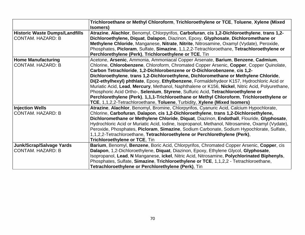
70
Trichloroethane or Methyl Chloroform, Trichloroethylene or TCE, Toluene, Xylene (Mixed Isomers)
Historic Waste Dumps/Landfills CONTAM. HAZARD: B
Atrazine, Alachlor, Benomyl, Chlorpyrifos, Carbofuran, cis 1,2-Dichloroethylene, trans 1,2-Dichloroethylene, Diquat, Dalapon, Diazinon, Epoxy, Glyphosate, Dichloromethane or Methylene Chloride, Manganese, Nitrate, Nitrite, Nitrosamine, Oxamyl (Vydate), Peroxide, Phosphates, Picloram, Sulfate, Simazine, 1,1,2,2-Tetrachloroethane, Tetrachloroethylene or Perchlorethylene (Perk), Trichloroethylene or TCE, Tin
Home Manufacturing CONTAM. HAZARD: B
Acetone, Arsenic, Ammonia, Ammoniacal Copper Arsenate, Barium, Benzene, Cadmium, Chlorine, Chlorobenzene, Chloroform, Chromated Copper Arsenic, Copper, Copper Quinolate, Carbon Tetrachloride, 1,2-Dichlorobenzene or O-Dichlorobenzene, cis 1,2-Dichloroethylene, trans 1,2-Dichloroethylene, Dichloromethane or Methylene Chloride, Di(2-ethylhexyl) phthlate, Epoxy, Ethylbenzene, Formaldehydeor K157, Hydrochloric Acid or Muriatic Acid, Lead, Mercury, Methanol, Naphthalene or K156, Nickel, Nitric Acid, Polyurethane, Phosphoric Acid Ortho-, Selenium, Styrene, Sulfuric Acid, Tetrachloroethylene or Perchlorethylene (Perk), 1,1,1-Trichloroethane or Methyl Chloroform, Trichloroethylene or TCE, 1,1,2,2-Tetrachloroethane, Toluene, Turbidity, Xylene (Mixed Isomers)
Injection Wells CONTAM. HAZARD: B
Atrazine, Alachlor, Benomyl, Bromine, Chlorpyrifos, Cyanuric Acid, Calcium Hypochlorate, Chlorine, Carbofuran, Dalapon, cis 1,2-Dichloroethylene, trans 1,2-Dichloroethylene, Dichloromethane or Methylene Chloride, Diquat, Diazinon, Endothall, Flouride, Glyphosate, Hydrochloric Acid or Muriatic Acid, Iodine, Isopropanol, Methanol, Nitrosamine, Oxamyl (Vydate), Peroxide, Phosphates, Picloram, Simazine, Sodium Carbonate, Sodium Hypochlorate, Sulfate, 1,1,2,2-Tetrachloroethane, Tetrachloroethylene or Perchlorethylene (Perk), Trichloroethylene or TCE, Tin
Junk/Scrap/Salvage Yards CONTAM. HAZARD: B
Barium, Benomyl, Benzene, Boric Acid, Chlorpyrifos, Chromated Copper Arsenic, Copper, cis Dalapon, 1,2-Dichloroethylene, Diquat, Diazinon, Epoxy, Ethylene Glycol, Glyphosate, Isopropanol, Lead, N Manganese, ickel, Nitric Acid, Nitrosamine, Polychlorinated Biphenyls, Phosphates, Sulfate, Simazine, Trichloroethylene or TCE, 1,1,2,2 - Tetrachloroethane, Tetrachloroethylene or Perchlorethylene (Perk), Tin
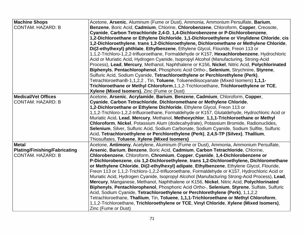
71
Machine Shops CONTAM. HAZARD: B
Acetone, Arsenic, Aluminum (Fume or Dust), Ammonia, Ammonium Persulfate, Barium, Benzene, Boric Acid, Cadmium, Chlorine, Chlorobenzene, Chloroform, Copper, Creosote, Cyanide, Carbon Tetrachloride 2,4-D, 1,4-Dichlorobenzene or P-Dichlorobenzene, 1,2-Dichloroethane or Ethylene Dichloride, 1,1-Dichloroethylene or Vinylidene Chloride, cis 1,2-Dichloroethylene, trans 1,2-Dichloroethylene, Dichloromethane or Methylene Chloride, Di(2-ethylhexyl) phthlate, Ethylbenzene, Ethylene Glycol, Flouride, Freon 113 or 1,1,2-Trichloro-1,2,2-trifluoroethane, Formaldehyde or K157, Hexachlorobenzene, Hydrochloric Acid or Muriatic Acid, Hydrogen Cyanide, Isopropyl Alcohol (Manufacturing, Strong-Acid Process), Lead, Mercury, Methanol, Naphthalene or K156, Nickel, Nitric Acid, Polychlorinated Biphenyls, Pentachlorophenol, Phosphoric Acid Ortho-, Selenium, Strychnine, Styrene, Sulfuric Acid, Sodium Cyanide, Tetrachloroethylene or Perchlorethylene (Perk), TetrachloroethanB-1,1,2,2 , Tin, Toluene, Toluenediisocyanate (Mixed Isomers) 1,1,1-Trichloroethane or Methyl Chloroform,1,1,2-Trichloroethane, Trichloroethylene or TCE, Xylene (Mixed Isomers), Zinc (Fume or Dust)
Medical/Vet Offices CONTAM. HAZARD: B
Acetone, Arsenic, Acrylamide, Barium, Benzene, Cadmium, Chloroform, Copper, Cyanide, Carbon Tetrachloride, Dichloromethane or Methylene Chloride, 1,2-Dichloroethane or Ethylene Dichloride, Ethylene Glycol, Freon 113 or 1,1,2-Trichloro-1,2,2-trifluoroethane, Formaldehyde or K157, Glutaldehyde, Hydrochloric Acid or Muriatic Acid, Lead, Mercury, Methanol, Methoxychlor, 1,1,1-Trichloroethane or Methyl Chloroform, Nickel, Potassium Alum (dodecahydrate), Potassium Bromide, Radionuclides, Selenium, Silver, Sulfuric Acid, Sodium Carbonate, Sodium Cyanide, Sodium Sulfite, Sulfuric Acid, Tetrachloroethylene or Perchlorethylene (Perk), 2,4,5-TP (Silvex), Thallium, Thiosulfates, Toluene, Xylene (Mixed Isomers)
Metal Plating/Finishing/Fabricating CONTAM. HAZARD: B
Acetone, Antimony, Acetylene, Aluminum (Fume or Dust), Ammonia, Ammonium Persulfate, Arsenic, Barium, Benzene, Boric Acid, Cadmium, Carbon Tetrachloride, Chlorine, Chlorobenzene, Chloroform, Chromium, Copper, Cyanide, 1,4-Dichlorobenzene or P-Dichlorobenzene, cis 1,2-Dichloroethylene, trans 1,2-Dichloroethylene, Dichloromethane or Methylene Chloride, Di(2-ethylhexyl) adipate, Ethylbenzene, Ethylene Glycol, Flouride, Freon 113 or 1,1,2-Trichloro-1,2,2-trifluoroethane, Formaldehyde or K157, Hydrochloric Acid or Muriatic Acid, Hydrogen Cyanide, Isopropyl Alcohol (Manufacturing Strong-Acid Process), Lead, Mercury, Manganese, Methanol, Naphthalene or K156, Nickel, Nitric Acid, Polychlorinated Biphenyls, Pentachlorophenol, Phosphoric Acid Ortho-, Selenium, Styrene, Sulfate, Sulfuric Acid, Sodium Cyanide, Tetrachloroethylene or Perchlorethylene (Perk), 1,1,2,2 Tetrachloroethane, Thallium, Tin, Toluene, 1,1,1-Trichloroethane or Methyl Chloroform, 1,1,2-Trichloroethane, Trichloroethylene or TCE, Vinyl Chloride, Xylene (Mixed Isomers), Zinc (Fume or Dust)
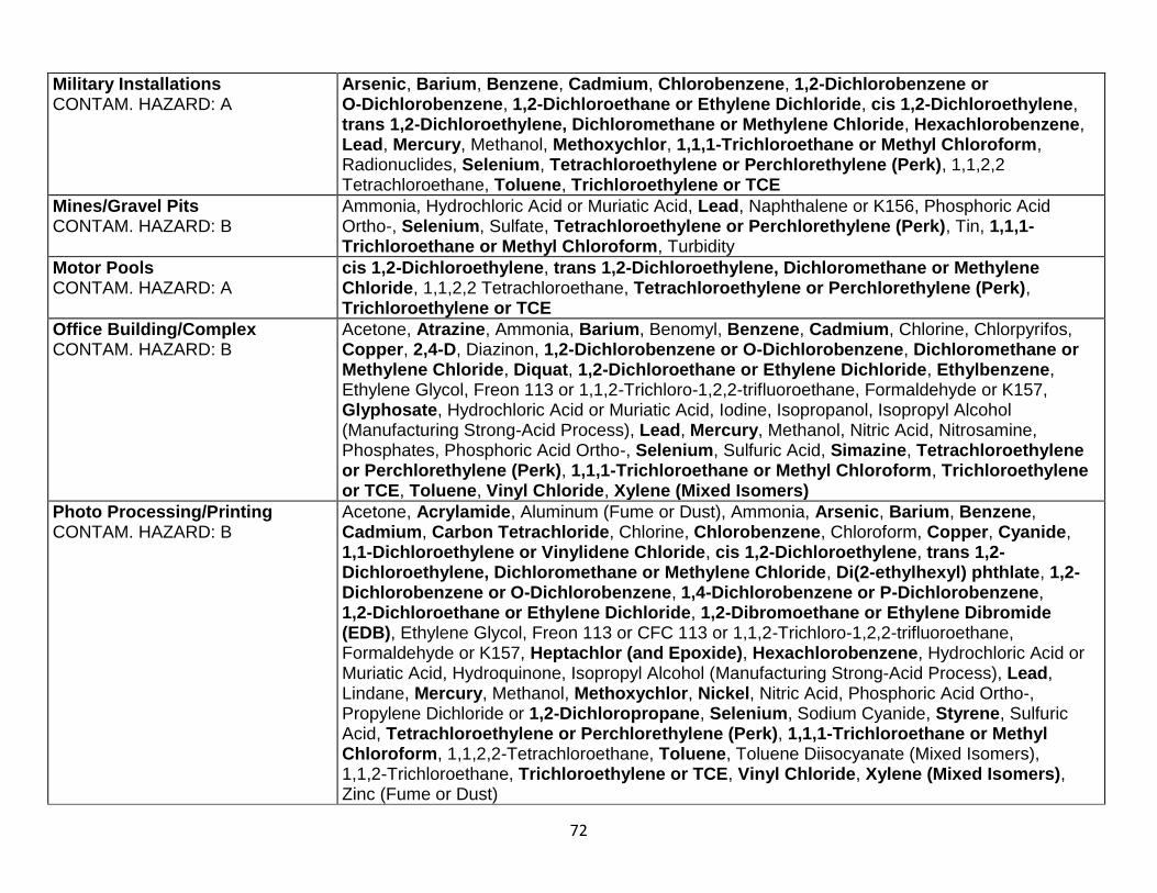
72
Military Installations CONTAM. HAZARD: A
Arsenic, Barium, Benzene, Cadmium, Chlorobenzene, 1,2-Dichlorobenzene or O-Dichlorobenzene, 1,2-Dichloroethane or Ethylene Dichloride, cis 1,2-Dichloroethylene, trans 1,2-Dichloroethylene, Dichloromethane or Methylene Chloride, Hexachlorobenzene, Lead, Mercury, Methanol, Methoxychlor, 1,1,1-Trichloroethane or Methyl Chloroform, Radionuclides, Selenium, Tetrachloroethylene or Perchlorethylene (Perk), 1,1,2,2 Tetrachloroethane, Toluene, Trichloroethylene or TCE
Mines/Gravel Pits CONTAM. HAZARD: B
Ammonia, Hydrochloric Acid or Muriatic Acid, Lead, Naphthalene or K156, Phosphoric Acid Ortho-, Selenium, Sulfate, Tetrachloroethylene or Perchlorethylene (Perk), Tin, 1,1,1-Trichloroethane or Methyl Chloroform, Turbidity
Motor Pools CONTAM. HAZARD: A
cis 1,2-Dichloroethylene, trans 1,2-Dichloroethylene, Dichloromethane or Methylene Chloride, 1,1,2,2 Tetrachloroethane, Tetrachloroethylene or Perchlorethylene (Perk), Trichloroethylene or TCE
Office Building/Complex CONTAM. HAZARD: B
Acetone, Atrazine, Ammonia, Barium, Benomyl, Benzene, Cadmium, Chlorine, Chlorpyrifos, Copper, 2,4-D, Diazinon, 1,2-Dichlorobenzene or O-Dichlorobenzene, Dichloromethane or Methylene Chloride, Diquat, 1,2-Dichloroethane or Ethylene Dichloride, Ethylbenzene, Ethylene Glycol, Freon 113 or 1,1,2-Trichloro-1,2,2-trifluoroethane, Formaldehyde or K157, Glyphosate, Hydrochloric Acid or Muriatic Acid, Iodine, Isopropanol, Isopropyl Alcohol (Manufacturing Strong-Acid Process), Lead, Mercury, Methanol, Nitric Acid, Nitrosamine, Phosphates, Phosphoric Acid Ortho-, Selenium, Sulfuric Acid, Simazine, Tetrachloroethylene or Perchlorethylene (Perk), 1,1,1-Trichloroethane or Methyl Chloroform, Trichloroethylene or TCE, Toluene, Vinyl Chloride, Xylene (Mixed Isomers)
Photo Processing/Printing CONTAM. HAZARD: B
Acetone, Acrylamide, Aluminum (Fume or Dust), Ammonia, Arsenic, Barium, Benzene, Cadmium, Carbon Tetrachloride, Chlorine, Chlorobenzene, Chloroform, Copper, Cyanide, 1,1-Dichloroethylene or Vinylidene Chloride, cis 1,2-Dichloroethylene, trans 1,2-Dichloroethylene, Dichloromethane or Methylene Chloride, Di(2-ethylhexyl) phthlate, 1,2-Dichlorobenzene or O-Dichlorobenzene, 1,4-Dichlorobenzene or P-Dichlorobenzene, 1,2-Dichloroethane or Ethylene Dichloride, 1,2-Dibromoethane or Ethylene Dibromide (EDB), Ethylene Glycol, Freon 113 or CFC 113 or 1,1,2-Trichloro-1,2,2-trifluoroethane, Formaldehyde or K157, Heptachlor (and Epoxide), Hexachlorobenzene, Hydrochloric Acid or Muriatic Acid, Hydroquinone, Isopropyl Alcohol (Manufacturing Strong-Acid Process), Lead, Lindane, Mercury, Methanol, Methoxychlor, Nickel, Nitric Acid, Phosphoric Acid Ortho-, Propylene Dichloride or 1,2-Dichloropropane, Selenium, Sodium Cyanide, Styrene, Sulfuric Acid, Tetrachloroethylene or Perchlorethylene (Perk), 1,1,1-Trichloroethane or Methyl Chloroform, 1,1,2,2-Tetrachloroethane, Toluene, Toluene Diisocyanate (Mixed Isomers), 1,1,2-Trichloroethane, Trichloroethylene or TCE, Vinyl Chloride, Xylene (Mixed Isomers), Zinc (Fume or Dust)
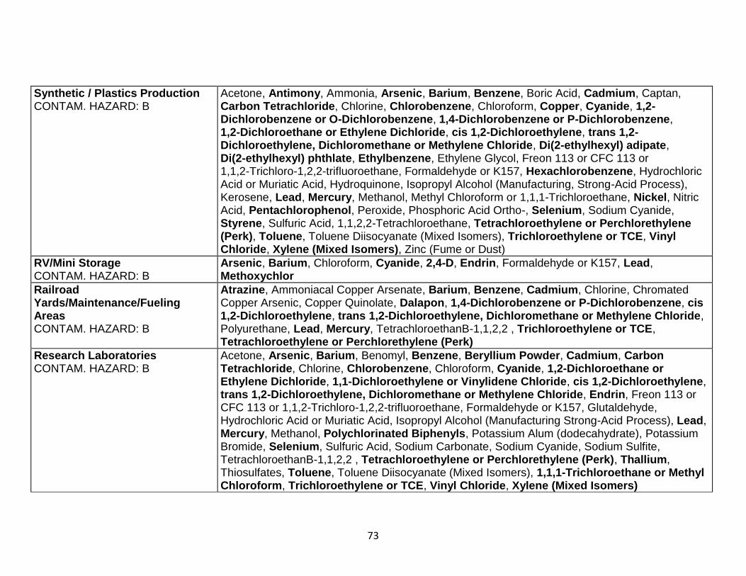
73
Synthetic / Plastics Production CONTAM. HAZARD: B
Acetone, Antimony, Ammonia, Arsenic, Barium, Benzene, Boric Acid, Cadmium, Captan, Carbon Tetrachloride, Chlorine, Chlorobenzene, Chloroform, Copper, Cyanide, 1,2-Dichlorobenzene or O-Dichlorobenzene, 1,4-Dichlorobenzene or P-Dichlorobenzene, 1,2-Dichloroethane or Ethylene Dichloride, cis 1,2-Dichloroethylene, trans 1,2-Dichloroethylene, Dichloromethane or Methylene Chloride, Di(2-ethylhexyl) adipate, Di(2-ethylhexyl) phthlate, Ethylbenzene, Ethylene Glycol, Freon 113 or CFC 113 or 1,1,2-Trichloro-1,2,2-trifluoroethane, Formaldehyde or K157, Hexachlorobenzene, Hydrochloric Acid or Muriatic Acid, Hydroquinone, Isopropyl Alcohol (Manufacturing, Strong-Acid Process), Kerosene, Lead, Mercury, Methanol, Methyl Chloroform or 1,1,1-Trichloroethane, Nickel, Nitric Acid, Pentachlorophenol, Peroxide, Phosphoric Acid Ortho-, Selenium, Sodium Cyanide, Styrene, Sulfuric Acid, 1,1,2,2-Tetrachloroethane, Tetrachloroethylene or Perchlorethylene (Perk), Toluene, Toluene Diisocyanate (Mixed Isomers), Trichloroethylene or TCE, Vinyl Chloride, Xylene (Mixed Isomers), Zinc (Fume or Dust)
RV/Mini Storage CONTAM. HAZARD: B
Arsenic, Barium, Chloroform, Cyanide, 2,4-D, Endrin, Formaldehyde or K157, Lead, Methoxychlor
Railroad Yards/Maintenance/Fueling Areas CONTAM. HAZARD: B
Atrazine, Ammoniacal Copper Arsenate, Barium, Benzene, Cadmium, Chlorine, Chromated Copper Arsenic, Copper Quinolate, Dalapon, 1,4-Dichlorobenzene or P-Dichlorobenzene, cis 1,2-Dichloroethylene, trans 1,2-Dichloroethylene, Dichloromethane or Methylene Chloride, Polyurethane, Lead, Mercury, TetrachloroethanB-1,1,2,2 , Trichloroethylene or TCE, Tetrachloroethylene or Perchlorethylene (Perk)
Research Laboratories CONTAM. HAZARD: B
Acetone, Arsenic, Barium, Benomyl, Benzene, Beryllium Powder, Cadmium, Carbon Tetrachloride, Chlorine, Chlorobenzene, Chloroform, Cyanide, 1,2-Dichloroethane or Ethylene Dichloride, 1,1-Dichloroethylene or Vinylidene Chloride, cis 1,2-Dichloroethylene, trans 1,2-Dichloroethylene, Dichloromethane or Methylene Chloride, Endrin, Freon 113 or CFC 113 or 1,1,2-Trichloro-1,2,2-trifluoroethane, Formaldehyde or K157, Glutaldehyde, Hydrochloric Acid or Muriatic Acid, Isopropyl Alcohol (Manufacturing Strong-Acid Process), Lead, Mercury, Methanol, Polychlorinated Biphenyls, Potassium Alum (dodecahydrate), Potassium Bromide, Selenium, Sulfuric Acid, Sodium Carbonate, Sodium Cyanide, Sodium Sulfite, TetrachloroethanB-1,1,2,2 , Tetrachloroethylene or Perchlorethylene (Perk), Thallium, Thiosulfates, Toluene, Toluene Diisocyanate (Mixed Isomers), 1,1,1-Trichloroethane or Methyl Chloroform, Trichloroethylene or TCE, Vinyl Chloride, Xylene (Mixed Isomers)
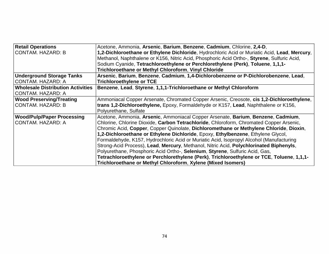
74
Retail Operations CONTAM. HAZARD: B
Acetone, Ammonia, Arsenic, Barium, Benzene, Cadmium, Chlorine, 2,4-D, 1,2-Dichloroethane or Ethylene Dichloride, Hydrochloric Acid or Muriatic Acid, Lead, Mercury, Methanol, Naphthalene or K156, Nitric Acid, Phosphoric Acid Ortho-, Styrene, Sulfuric Acid, Sodium Cyanide, Tetrachloroethylene or Perchlorethylene (Perk), Toluene, 1,1,1-Trichloroethane or Methyl Chloroform, Vinyl Chloride
Underground Storage Tanks CONTAM. HAZARD: A
Arsenic, Barium, Benzene, Cadmium, 1,4-Dichlorobenzene or P-Dichlorobenzene, Lead, Trichloroethylene or TCE
Wholesale Distribution Activities CONTAM. HAZARD: A
Benzene, Lead, Styrene, 1,1,1-Trichloroethane or Methyl Chloroform
Wood Preserving/Treating CONTAM. HAZARD: B
Ammoniacal Copper Arsenate, Chromated Copper Arsenic, Creosote, cis 1,2-Dichloroethylene, trans 1,2-Dichloroethylene, Epoxy, Formaldehyde or K157, Lead, Naphthalene or K156, Polyurethane, Sulfate
Wood/Pulp/Paper Processing CONTAM. HAZARD: A
Acetone, Ammonia, Arsenic, Ammoniacal Copper Arsenate, Barium, Benzene, Cadmium, Chlorine, Chlorine Dioxide, Carbon Tetrachloride, Chloroform, Chromated Copper Arsenic, Chromic Acid, Copper, Copper Quinolate, Dichloromethane or Methylene Chloride, Dioxin, 1,2-Dichloroethane or Ethylene Dichloride, Epoxy, Ethylbenzene, Ethylene Glycol, Formaldehyde, K157, Hydrochloric Acid or Muriatic Acid, Isopropyl Alcohol (Manufacturing Strong-Acid Process), Lead, Mercury, Methanol, Nitric Acid, Polychlorinated Biphenyls, Polyurethane, Phosphoric Acid Ortho-, Selenium, Styrene, Sulfuric Acid, Gas, Tetrachloroethylene or Perchlorethylene (Perk), Trichloroethylene or TCE, Toluene, 1,1,1-Trichloroethane or Methyl Chloroform, Xylene (Mixed Isomers)
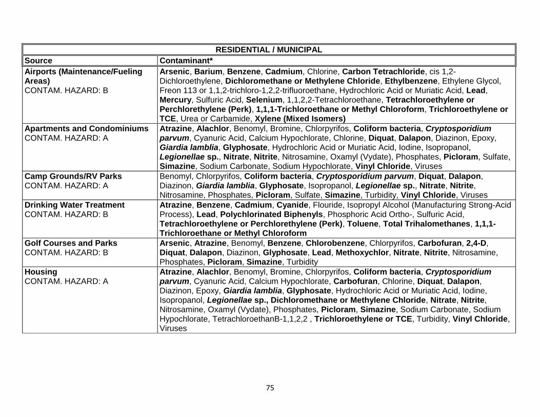
75
RESIDENTIAL / MUNICIPAL
Source Contaminant*
Airports (Maintenance/Fueling Areas) CONTAM. HAZARD: B
Arsenic, Barium, Benzene, Cadmium, Chlorine, Carbon Tetrachloride, cis 1,2- Dichloroethylene, Dichloromethane or Methylene Chloride, Ethylbenzene, Ethylene Glycol, Freon 113 or 1,1,2-trichloro-1,2,2-trifluoroethane, Hydrochloric Acid or Muriatic Acid, Lead, Mercury, Sulfuric Acid, Selenium, 1,1,2,2-Tetrachloroethane, Tetrachloroethylene or Perchlorethylene (Perk), 1,1,1-Trichloroethane or Methyl Chloroform, Trichloroethylene or TCE, Urea or Carbamide, Xylene (Mixed Isomers)
Apartments and Condominiums CONTAM. HAZARD: A
Atrazine, Alachlor, Benomyl, Bromine, Chlorpyrifos, Coliform bacteria, Cryptosporidium parvum, Cyanuric Acid, Calcium Hypochlorate, Chlorine, Diquat, Dalapon, Diazinon, Epoxy, Giardia lamblia, Glyphosate, Hydrochloric Acid or Muriatic Acid, Iodine, Isopropanol, Legionellae sp., Nitrate, Nitrite, Nitrosamine, Oxamyl (Vydate), Phosphates, Picloram, Sulfate, Simazine, Sodium Carbonate, Sodium Hypochlorate, Vinyl Chloride, Viruses
Camp Grounds/RV Parks CONTAM. HAZARD: A
Benomyl, Chlorpyrifos, Coliform bacteria, Cryptosporidium parvum, Diquat, Dalapon, Diazinon, Giardia lamblia, Glyphosate, Isopropanol, Legionellae sp., Nitrate, Nitrite, Nitrosamine, Phosphates, Picloram, Sulfate, Simazine, Turbidity, Vinyl Chloride, Viruses
Drinking Water Treatment CONTAM. HAZARD: B
Atrazine, Benzene, Cadmium, Cyanide, Flouride, Isopropyl Alcohol (Manufacturing Strong-Acid Process), Lead, Polychlorinated Biphenyls, Phosphoric Acid Ortho-, Sulfuric Acid, Tetrachloroethylene or Perchlorethylene (Perk), Toluene, Total Trihalomethanes, 1,1,1-Trichloroethane or Methyl Chloroform
Golf Courses and Parks CONTAM. HAZARD: B
Arsenic, Atrazine, Benomyl, Benzene, Chlorobenzene, Chlorpyrifos, Carbofuran, 2,4-D, Diquat, Dalapon, Diazinon, Glyphosate, Lead, Methoxychlor, Nitrate, Nitrite, Nitrosamine, Phosphates, Picloram, Simazine, Turbidity
Housing CONTAM. HAZARD: A
Atrazine, Alachlor, Benomyl, Bromine, Chlorpyrifos, Coliform bacteria, Cryptosporidium parvum, Cyanuric Acid, Calcium Hypochlorate, Carbofuran, Chlorine, Diquat, Dalapon, Diazinon, Epoxy, Giardia lamblia, Glyphosate, Hydrochloric Acid or Muriatic Acid, Iodine, Isopropanol, Legionellae sp., Dichloromethane or Methylene Chloride, Nitrate, Nitrite, Nitrosamine, Oxamyl (Vydate), Phosphates, Picloram, Simazine, Sodium Carbonate, Sodium Hypochlorate, TetrachloroethanB-1,1,2,2 , Trichloroethylene or TCE, Turbidity, Vinyl Chloride, Viruses
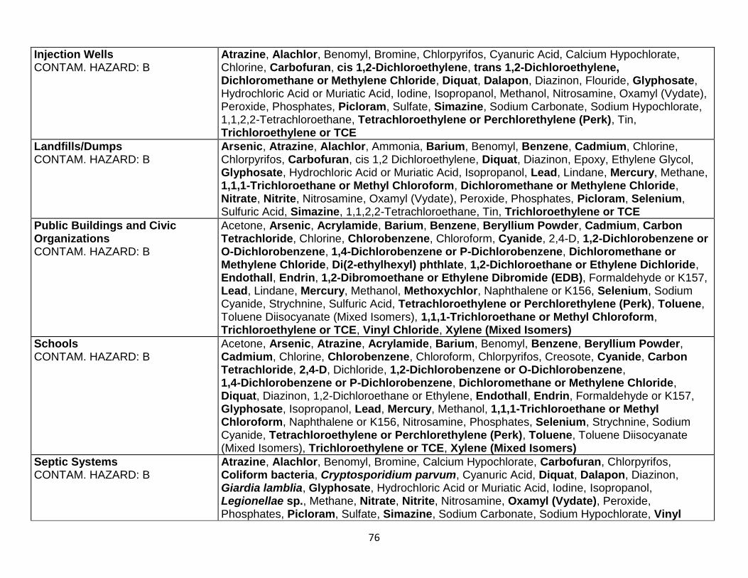
76
Injection Wells CONTAM. HAZARD: B
Atrazine, Alachlor, Benomyl, Bromine, Chlorpyrifos, Cyanuric Acid, Calcium Hypochlorate, Chlorine, Carbofuran, cis 1,2-Dichloroethylene, trans 1,2-Dichloroethylene, Dichloromethane or Methylene Chloride, Diquat, Dalapon, Diazinon, Flouride, Glyphosate, Hydrochloric Acid or Muriatic Acid, Iodine, Isopropanol, Methanol, Nitrosamine, Oxamyl (Vydate), Peroxide, Phosphates, Picloram, Sulfate, Simazine, Sodium Carbonate, Sodium Hypochlorate, 1,1,2,2-Tetrachloroethane, Tetrachloroethylene or Perchlorethylene (Perk), Tin, Trichloroethylene or TCE
Landfills/Dumps CONTAM. HAZARD: B
Arsenic, Atrazine, Alachlor, Ammonia, Barium, Benomyl, Benzene, Cadmium, Chlorine, Chlorpyrifos, Carbofuran, cis 1,2 Dichloroethylene, Diquat, Diazinon, Epoxy, Ethylene Glycol, Glyphosate, Hydrochloric Acid or Muriatic Acid, Isopropanol, Lead, Lindane, Mercury, Methane, 1,1,1-Trichloroethane or Methyl Chloroform, Dichloromethane or Methylene Chloride, Nitrate, Nitrite, Nitrosamine, Oxamyl (Vydate), Peroxide, Phosphates, Picloram, Selenium, Sulfuric Acid, Simazine, 1,1,2,2-Tetrachloroethane, Tin, Trichloroethylene or TCE
Public Buildings and Civic Organizations CONTAM. HAZARD: B
Acetone, Arsenic, Acrylamide, Barium, Benzene, Beryllium Powder, Cadmium, Carbon Tetrachloride, Chlorine, Chlorobenzene, Chloroform, Cyanide, 2,4-D, 1,2-Dichlorobenzene or O-Dichlorobenzene, 1,4-Dichlorobenzene or P-Dichlorobenzene, Dichloromethane or Methylene Chloride, Di(2-ethylhexyl) phthlate, 1,2-Dichloroethane or Ethylene Dichloride, Endothall, Endrin, 1,2-Dibromoethane or Ethylene Dibromide (EDB), Formaldehyde or K157, Lead, Lindane, Mercury, Methanol, Methoxychlor, Naphthalene or K156, Selenium, Sodium Cyanide, Strychnine, Sulfuric Acid, Tetrachloroethylene or Perchlorethylene (Perk), Toluene, Toluene Diisocyanate (Mixed Isomers), 1,1,1-Trichloroethane or Methyl Chloroform, Trichloroethylene or TCE, Vinyl Chloride, Xylene (Mixed Isomers)
Schools CONTAM. HAZARD: B
Acetone, Arsenic, Atrazine, Acrylamide, Barium, Benomyl, Benzene, Beryllium Powder, Cadmium, Chlorine, Chlorobenzene, Chloroform, Chlorpyrifos, Creosote, Cyanide, Carbon Tetrachloride, 2,4-D, Dichloride, 1,2-Dichlorobenzene or O-Dichlorobenzene, 1,4-Dichlorobenzene or P-Dichlorobenzene, Dichloromethane or Methylene Chloride, Diquat, Diazinon, 1,2-Dichloroethane or Ethylene, Endothall, Endrin, Formaldehyde or K157, Glyphosate, Isopropanol, Lead, Mercury, Methanol, 1,1,1-Trichloroethane or Methyl Chloroform, Naphthalene or K156, Nitrosamine, Phosphates, Selenium, Strychnine, Sodium Cyanide, Tetrachloroethylene or Perchlorethylene (Perk), Toluene, Toluene Diisocyanate (Mixed Isomers), Trichloroethylene or TCE, Xylene (Mixed Isomers)
Septic Systems CONTAM. HAZARD: B
Atrazine, Alachlor, Benomyl, Bromine, Calcium Hypochlorate, Carbofuran, Chlorpyrifos, Coliform bacteria, Cryptosporidium parvum, Cyanuric Acid, Diquat, Dalapon, Diazinon, Giardia lamblia, Glyphosate, Hydrochloric Acid or Muriatic Acid, Iodine, Isopropanol, Legionellae sp., Methane, Nitrate, Nitrite, Nitrosamine, Oxamyl (Vydate), Peroxide, Phosphates, Picloram, Sulfate, Simazine, Sodium Carbonate, Sodium Hypochlorate, Vinyl
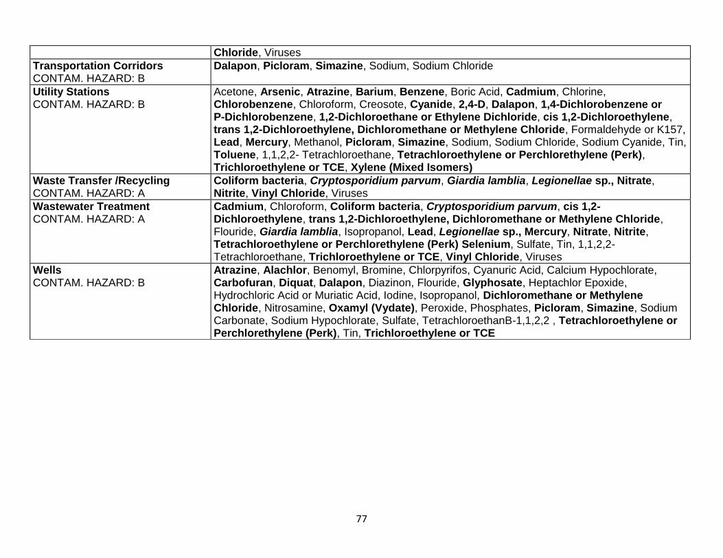
77
Chloride, Viruses
Transportation Corridors CONTAM. HAZARD: B
Dalapon, Picloram, Simazine, Sodium, Sodium Chloride
Utility Stations CONTAM. HAZARD: B
Acetone, Arsenic, Atrazine, Barium, Benzene, Boric Acid, Cadmium, Chlorine, Chlorobenzene, Chloroform, Creosote, Cyanide, 2,4-D, Dalapon, 1,4-Dichlorobenzene or P-Dichlorobenzene, 1,2-Dichloroethane or Ethylene Dichloride, cis 1,2-Dichloroethylene, trans 1,2-Dichloroethylene, Dichloromethane or Methylene Chloride, Formaldehyde or K157, Lead, Mercury, Methanol, Picloram, Simazine, Sodium, Sodium Chloride, Sodium Cyanide, Tin, Toluene, 1,1,2,2- Tetrachloroethane, Tetrachloroethylene or Perchlorethylene (Perk), Trichloroethylene or TCE, Xylene (Mixed Isomers)
Waste Transfer /Recycling CONTAM. HAZARD: A
Coliform bacteria, Cryptosporidium parvum, Giardia lamblia, Legionellae sp., Nitrate, Nitrite, Vinyl Chloride, Viruses
Wastewater Treatment CONTAM. HAZARD: A
Cadmium, Chloroform, Coliform bacteria, Cryptosporidium parvum, cis 1,2-Dichloroethylene, trans 1,2-Dichloroethylene, Dichloromethane or Methylene Chloride, Flouride, Giardia lamblia, Isopropanol, Lead, Legionellae sp., Mercury, Nitrate, Nitrite, Tetrachloroethylene or Perchlorethylene (Perk) Selenium, Sulfate, Tin, 1,1,2,2-Tetrachloroethane, Trichloroethylene or TCE, Vinyl Chloride, Viruses
Wells CONTAM. HAZARD: B
Atrazine, Alachlor, Benomyl, Bromine, Chlorpyrifos, Cyanuric Acid, Calcium Hypochlorate, Carbofuran, Diquat, Dalapon, Diazinon, Flouride, Glyphosate, Heptachlor Epoxide, Hydrochloric Acid or Muriatic Acid, Iodine, Isopropanol, Dichloromethane or Methylene Chloride, Nitrosamine, Oxamyl (Vydate), Peroxide, Phosphates, Picloram, Simazine, Sodium Carbonate, Sodium Hypochlorate, Sulfate, TetrachloroethanB-1,1,2,2 , Tetrachloroethylene or Perchlorethylene (Perk), Tin, Trichloroethylene or TCE

78
AGRICULTURAL / RURAL
Source Contaminant*
Auction Lots/Boarding Stables CONTAM. HAZARD: A
Coliform bacteria, Cryptosporidium parvum, Giardia lamblia, Legionellae sp., Nitrate, Nitrite, Sulfate
Confined Animal Feeding Operations CONTAM. HAZARD: A
Coliform bacteria, Cryptosporidium parvum, Freon 113 or 1,1,2-Trichloro-1,2,2-trifluoroethane, Giardia lamblia, Legionellae sp., Nitrate, Nitric Acid, Nitrite, Sulfate, Vinyl Chloride, Viruses
Crops - Irrigated + Nonirrigated CONTAM. HAZARD: B
Acetone, Ammonia, Benzene, 2,4-D, Dalapon, Dinoseb, Diquat, Glyphosate, Lindane, Lead, Nitrate, Nitrite, Phosphoric Acid Ortho-, Picloram, Simazine, Sulfuric Acid, Turbidity
Injection Wells CONTAM. HAZARD: B
Atrazine, Alachlor, Benomyl, Bromine, Calcium Hypochlorate, Carbofuran, Chlorpyrifos, Cyanuric Acid, Chlorine, Dalapon, Diazinon, cis 1,2-Dichloroethylene, trans 1,2-Dichloroethylene, Dichloromethane or Methylene Chloride, Diquat, Glyphosate, Hydrochloric Acid or Muriatic Acid, Iodine, Isopropanol, Methanol, Nitrosamine, Oxamyl (Vydate), Peroxide, Phosphates, Picloram, Sulfate, Simazine, Sodium Carbonate, Sodium Hypochlorate, 1,1,2,2-Tetrachloroethane, Tetrachloroethylene or Perchlorethylene (Perk), Trichloroethylene or TCE, Tin
Lagoons and Liquid Waste CONTAM. HAZARD: A
Atrazine, Alachlor, Coliform bacteria, Cryptosporidium parvum, Carbofuran, Diquat, Dalapon, Giardia lamblia, Glyphosate, Legionellae sp., Methane, Nitrate, Nitrite, Oxamyl (Vydate), Picloram, Sulfate, Simazine, Vinyl Chloride, Viruses
Managed Forests CONTAM. HAZARD: B
Atrazine, Diquat, Benomyl, Chlorpyrifos, Diazinon, Glyphosate, Nitrosamine, Phosphates, Picloram, Simazine, Turbidity
Pesticide/Fertilizer/Petroleum Storage CONTAM. HAZARD: B
Atrazine, Alachlor, Benomyl, Chlorpyrifos, Carbofuran, Chlordane, 2,4-D, Diquat, Dalapon, Diazinon, 1,2-Dibromo-3-Chloropropane or DBCP, Glyphosate, Nitrate, Nitrite, Nitrosamine, Oxamyl (Vydate), Phosphates, Phosphorus, Picloram, Strychnine, Simazine, 2,4-TP (Silvex)
Rural Homesteads CONTAM. HAZARD: A
Atrazine, Alachlor, Benomyl, Bromine, Calcium Hypochlorate, Carbofuran, Chlorine, Chlorpyrifos, Coliform bacteria, Cryptosporidium parvum, Cyanuric Acid, cis 1,2-Dichloroethylene, trans 1,2-Dichloroethylene, Diquat, Dalapon, Diazinon, Giardia lamblia, Glyphosate, Hydrochloric Acid or Muriatic Acid, Iodine, Isopropanol, Legionellae sp., Nitrate, Nitrite, Nitrosamine, Oxamyl (Vydate), Phosphates, Picloram, Sulfate, Simazine, Sodium Carbonate, Sodium Hypochlorate, Vinyl Chloride, Viruses
Naturally Occurring CONTAM. HAZARD: B
Antimony, Arsenic, Barium, Cadmium, Chloride, Chromium, Coliform, Copper, Cryptosporidium parvum, Fluoride, Giardia lamblia, Iron, Lead, Legionellae sp., Manganese, Mercury, Nickel, Radionuclides, Selenium, Silver, Sodium, Sulfate, Zinc
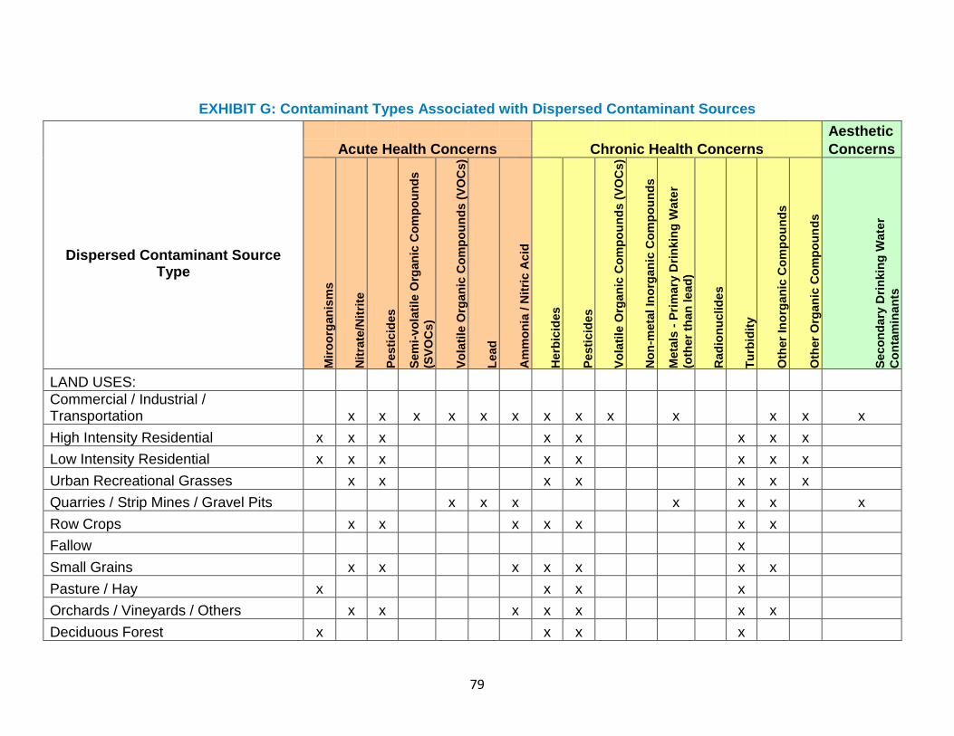
79
EXHIBIT G: Contaminant Types Associated with Dispersed Contaminant Sources
Aesthetic
Acute Health Concerns Chronic Health Concerns Concerns
Dispersed Contaminant Source Type
Mir
oo
rgan
ism
s
Nit
rate
/Nit
rite
Pesti
cid
es
Sem
i-vo
lati
le O
rgan
ic C
om
po
un
ds
(SV
OC
s)
Vo
lati
le O
rgan
ic C
om
po
un
ds (
VO
Cs)
Lead
Am
mo
nia
/ N
itri
c A
cid
Herb
icid
es
Pesti
cid
es
Vo
lati
le O
rgan
ic C
om
po
un
ds (
VO
Cs)
No
n-m
eta
l In
org
an
ic C
om
po
un
ds
Meta
ls -
Pri
mary
Dri
nkin
g W
ate
r
(oth
er
than
lead
)
Rad
ion
uclid
es
Tu
rbid
ity
Oth
er
Ino
rgan
ic C
om
po
un
ds
Oth
er
Org
an
ic C
om
po
un
ds
Seco
nd
ary
Dri
nkin
g W
ate
r
Co
nta
min
an
ts
LAND USES:
Commercial / Industrial / Transportation x x x x x x x x x x x x x
High Intensity Residential x x x x x x x x
Low Intensity Residential x x x x x x x x
Urban Recreational Grasses x x x x x x x
Quarries / Strip Mines / Gravel Pits x x x x x x x
Row Crops x x x x x x x
Fallow x
Small Grains x x x x x x x
Pasture / Hay x x x x
Orchards / Vineyards / Others x x x x x x x
Deciduous Forest x x x x
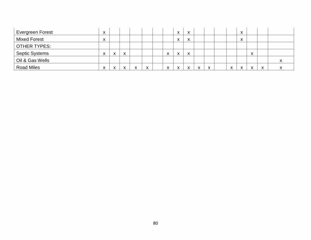
80
Evergreen Forest x x x x
Mixed Forest x x x x
OTHER TYPES:
Septic Systems x x x x x x x
Oil & Gas Wells x
Road Miles x x x x x x x x x x x x x x x
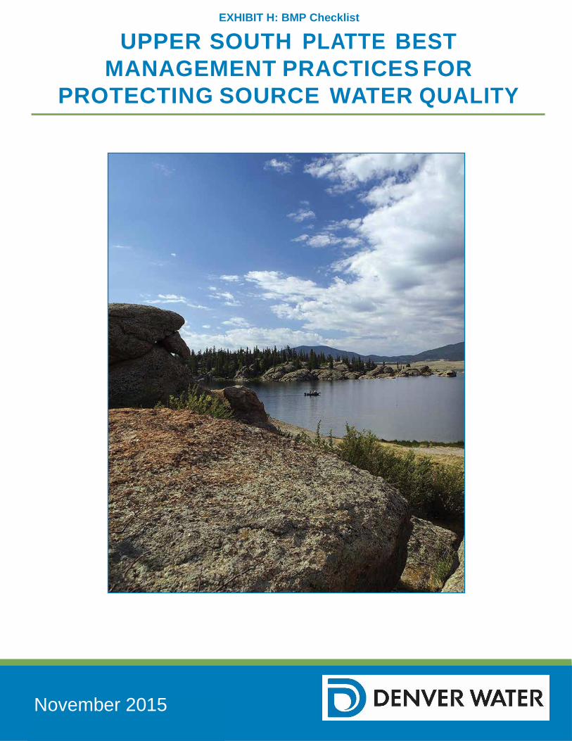
81
EXHIBIT H: BMP Checklist
UPPER SOUTH PLATTE BEST
MANAGEMENT PRACTICES FOR
PROTECTING SOURCE WATER QUALITY
November 2015
82
SUMMARY Protecting water quality throughout a watershed is a constant and challenging responsibility requiring persistent oversight and planning. The responsibility for protecting and preserving this most precious and invaluable resource falls to a broad range of stakeholders, beneficiaries, and end users. Individuals from county and local governments, federal agencies, land owners, local residents, and private sector project designers may not think of themselves as protectors and stewards of a region’s drinking water quality but, in fact, their decisions can have significant impacts on source water quality and supply. Water providers and utilities have added responsibility to ensure that the water they serve is safe for their customers. Denver Water understands the importance of maintaining high quality source water, as shown through Denver Water’s mission “to be a responsible steward of the resources, assets and natural environments entrusted to us in order to provide a high-quality water supply, a resilient and reliable system, and excellent customer service”. Denver Water has been collecting water quality and flow data in its watersheds since the 1970’s. After many revisions of the focus and design of the watershed monitoring efforts, the most recent Watershed Monitoring Project was launched in 2002. As part of an Integrated Resource Planning process in 2011, Denver Water concluded that its water treatment plants are fed by watersheds with relatively high quality water; consequently, the probability of needing to add advanced treatment technologies to these plants in the 20-year budgeting period is considered to be low. However, should advanced treatment be needed, it will be expensive. Cost estimates range from $1.0 to $1.8 billion depending on the technology implemented. Avoiding technology upgrades through watershed protection is anticipated to cost much less. In 2012, Denver Water selected the Upper South Platte River Watershed for its first preliminary water quality assessment and to develop a standard watershed evaluation approach that can be applied to the remaining watersheds. The watershed covers over 2,600-square-miles and reaches from the Continental Divide to the Strontia Springs Reservoir, southwest of Denver. It varies in elevation from about 6,000 feet to over 14,000 feet above sea level and contains five major municipal and several smaller reservoirs. The watershed is geographically the largest of Denver Water’s source water watersheds and provides municipal water for about three quarters of Colorado’s residents. It is a recreational mecca with over 1.6 million acres of public lands, renowned for its “gold-medal” fishing streams and is home to numerous threatened and endangered species. Denver Water hired ARCADIS in December 2012 to evaluate the water quality data for the Upper South Platte River in close collaboration with Denver Water staff and Jim C. Loftis, Ph.D. Professor in the Civil and Environmental Engineering Department at Colorado State University. The results from the water quality assessment demonstrated that the Upper South Platte Watershed is generally in good health and that water quality has been stable or improving over the last 10 years. Denver Water’s formal Upper South Platte Watershed Source Water Protection Planning process was initiated in 2013. The plan was developed as part of a collaborative stakeholder process convened by Denver Water, facilitated by the Coalition for the Upper South Platte, and
83
funded by the Colorado Department of Public Health and Environment through the Colorado Source Water Assessment and Protection program. The planning process and final plan are designed to provide municipal water providers, local governments and the public with information about drinking water, as well as provide a way for water providers and community members to get involved in protecting the quality of their drinking water. The program encourages community-based protection and preventive management strategies to ensure public drinking water resources are kept safe from future contamination. The planning process recognizes that decision makers, public water providers, and emergency response personnel all play key roles in protecting water quality, both in the short and long terms. They are the community’s front line to protect against spills and emergencies, deal with everyday contaminants of concern, mitigate negative impacts of development, and protect against long-term watershed degradation. For this reason, a Steering Committee comprised of broad stakeholders was convened to help direct the project. The Steering Committee worked with subject matter experts to develop Best Management Practices (BMPs) for contaminants of concern within the watershed. These BMPs will be implemented to protect against contamination from chemical spills, leaking fuel tanks, inadequate septic systems, nutrients from agriculture, mine contamination, oil and gas development, and forest fires. In addition, protecting against long-term watershed degradation requires coordination between land managers and public water providers. It is critical that decision makers, public water providers, and emergency planning personnel have an understanding of potential impacts on source water. Denver Water has been working with others in Colorado to improve water quality monitoring and evaluation, to increase participation in watershed groups, and to lobby for increased protection of drinking water sources. This plan for the Upper South Platte Watershed will serve as a guide and template for the development of plans in other watersheds upon which Denver Water’s customers depend. The following checklists are designed to assist these front line personnel in performing their water quality protection duties. The checklist is broken out into two sections; the first section details how to set up a plan and the second section provides specific checklist for topic areas that were developed during the plan setup. Section One of the checklist has been completed and can be used as a model for other Source Water Protection planning efforts.
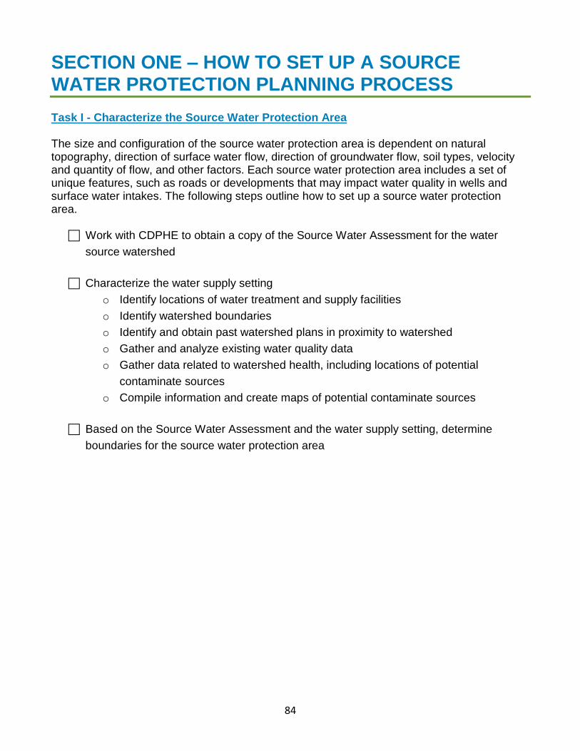
84
SECTION ONE – HOW TO SET UP A SOURCE WATER PROTECTION PLANNING PROCESS Task I - Characterize the Source Water Protection Area The size and configuration of the source water protection area is dependent on natural topography, direction of surface water flow, direction of groundwater flow, soil types, velocity and quantity of flow, and other factors. Each source water protection area includes a set of unique features, such as roads or developments that may impact water quality in wells and surface water intakes. The following steps outline how to set up a source water protection area.
Work with CDPHE to obtain a copy of the Source Water Assessment for the water
source watershed
Characterize the water supply setting
o Identify locations of water treatment and supply facilities
o Identify watershed boundaries
o Identify and obtain past watershed plans in proximity to watershed
o Gather and analyze existing water quality data
o Gather data related to watershed health, including locations of potential
contaminate sources
o Compile information and create maps of potential contaminate sources
Based on the Source Water Assessment and the water supply setting, determine
boundaries for the source water protection area
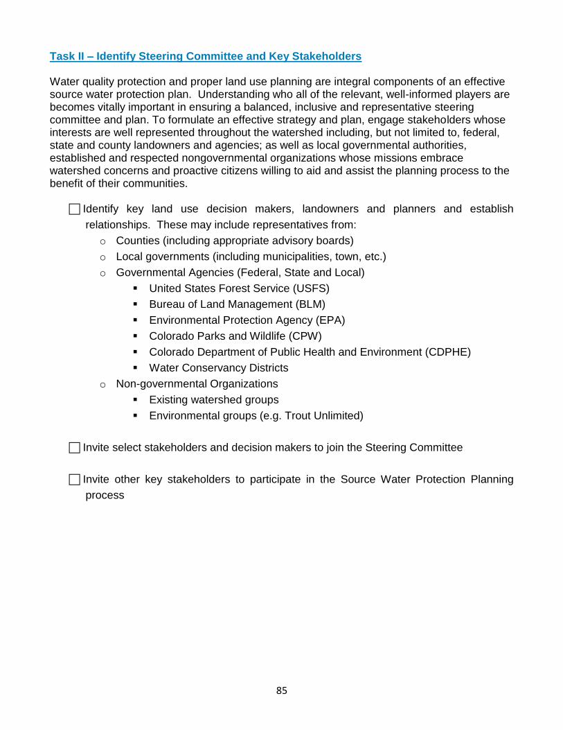
85
Task II – Identify Steering Committee and Key Stakeholders Water quality protection and proper land use planning are integral components of an effective source water protection plan. Understanding who all of the relevant, well-informed players are becomes vitally important in ensuring a balanced, inclusive and representative steering committee and plan. To formulate an effective strategy and plan, engage stakeholders whose interests are well represented throughout the watershed including, but not limited to, federal, state and county landowners and agencies; as well as local governmental authorities, established and respected nongovernmental organizations whose missions embrace watershed concerns and proactive citizens willing to aid and assist the planning process to the benefit of their communities.
Identify key land use decision makers, landowners and planners and establish
relationships. These may include representatives from:
o Counties (including appropriate advisory boards)
o Local governments (including municipalities, town, etc.)
o Governmental Agencies (Federal, State and Local)
United States Forest Service (USFS)
Bureau of Land Management (BLM)
Environmental Protection Agency (EPA)
Colorado Parks and Wildlife (CPW)
Colorado Department of Public Health and Environment (CDPHE)
Water Conservancy Districts
o Non-governmental Organizations
Existing watershed groups
Environmental groups (e.g. Trout Unlimited)
Invite select stakeholders and decision makers to join the Steering Committee
Invite other key stakeholders to participate in the Source Water Protection Planning
process
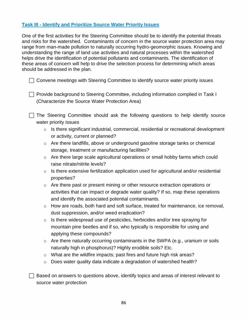
86
Task III - Identify and Prioritize Source Water Priority Issues One of the first activities for the Steering Committee should be to identify the potential threats and risks for the watershed. Contaminants of concern in the source water protection area may range from man-made pollution to naturally occurring hydro-geomorphic issues. Knowing and understanding the range of land use activities and natural processes within the watershed helps drive the identification of potential pollutants and contaminants. The identification of these areas of concern will help to drive the selection process for determining which areas should be addressed in the plan.
Convene meetings with Steering Committee to identify source water priority issues
Provide background to Steering Committee, including information complied in Task I
(Characterize the Source Water Protection Area)
The Steering Committee should ask the following questions to help identify source
water priority issues
o Is there significant industrial, commercial, residential or recreational development
or activity, current or planned?
o Are there landfills, above or underground gasoline storage tanks or chemical
storage, treatment or manufacturing facilities?
o Are there large scale agricultural operations or small hobby farms which could
raise nitrate/nitrite levels?
o Is there extensive fertilization application used for agricultural and/or residential
properties?
o Are there past or present mining or other resource extraction operations or
activities that can impact or degrade water quality? If so, map these operations
and identify the associated potential contaminants.
o How are roads, both hard and soft surface, treated for maintenance, ice removal,
dust suppression, and/or weed eradication?
o Is there widespread use of pesticides, herbicides and/or tree spraying for
mountain pine beetles and if so, who typically is responsible for using and
applying these compounds?
o Are there naturally occurring contaminants in the SWPA (e.g., uranium or soils
naturally high in phosphorus)? Highly erodible soils? Etc.
o What are the wildfire impacts; past fires and future high risk areas?
o Does water quality data indicate a degradation of watershed health?
Based on answers to questions above, identify topics and areas of interest relevant to
source water protection
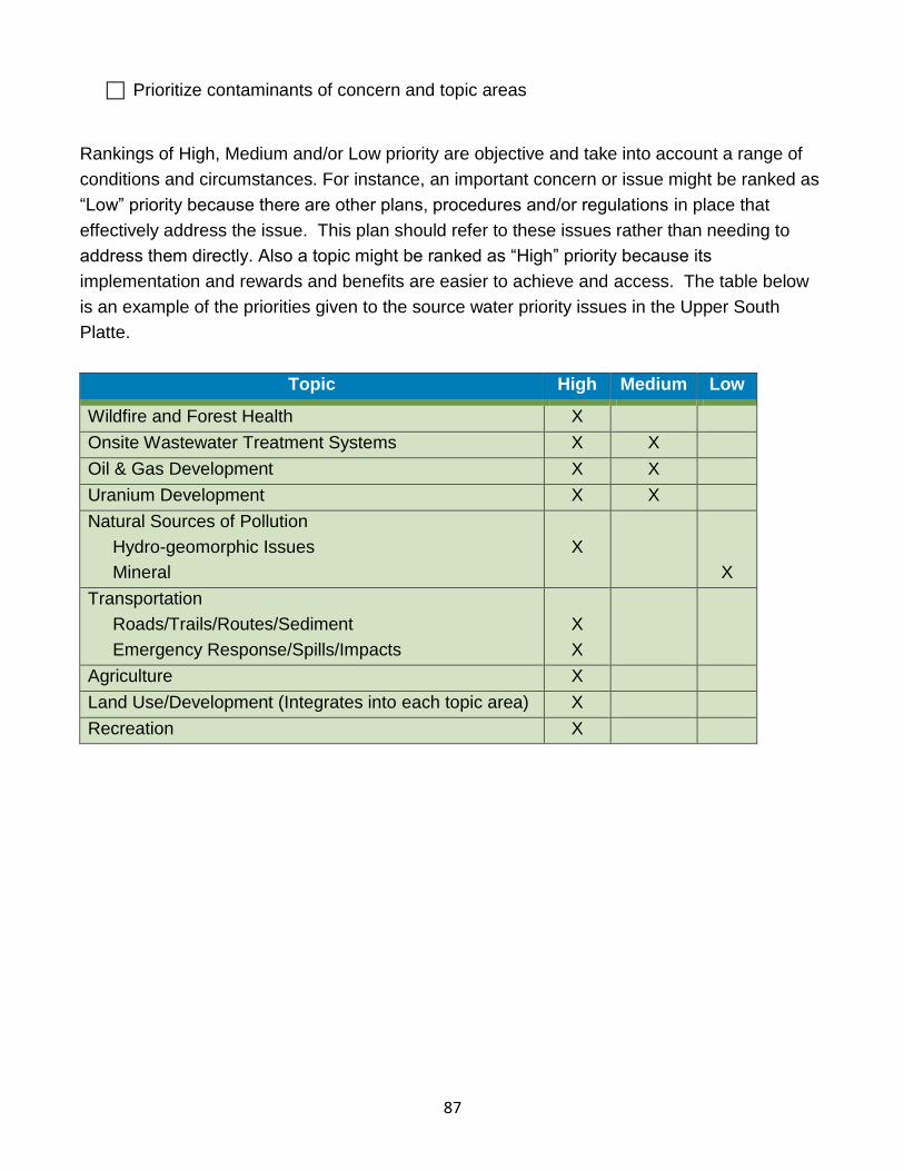
87
Prioritize contaminants of concern and topic areas
Rankings of High, Medium and/or Low priority are objective and take into account a range of
conditions and circumstances. For instance, an important concern or issue might be ranked as
“Low” priority because there are other plans, procedures and/or regulations in place that
effectively address the issue. This plan should refer to these issues rather than needing to
address them directly. Also a topic might be ranked as “High” priority because its
implementation and rewards and benefits are easier to achieve and access. The table below
is an example of the priorities given to the source water priority issues in the Upper South
Platte.
Topic High Medium Low
Wildfire and Forest Health X
Onsite Wastewater Treatment Systems X X
Oil & Gas Development X X
Uranium Development X X
Natural Sources of Pollution
Hydro-geomorphic Issues
Mineral
X
X
Transportation
Roads/Trails/Routes/Sediment
Emergency Response/Spills/Impacts
X
X
Agriculture X
Land Use/Development (Integrates into each topic area) X
Recreation X
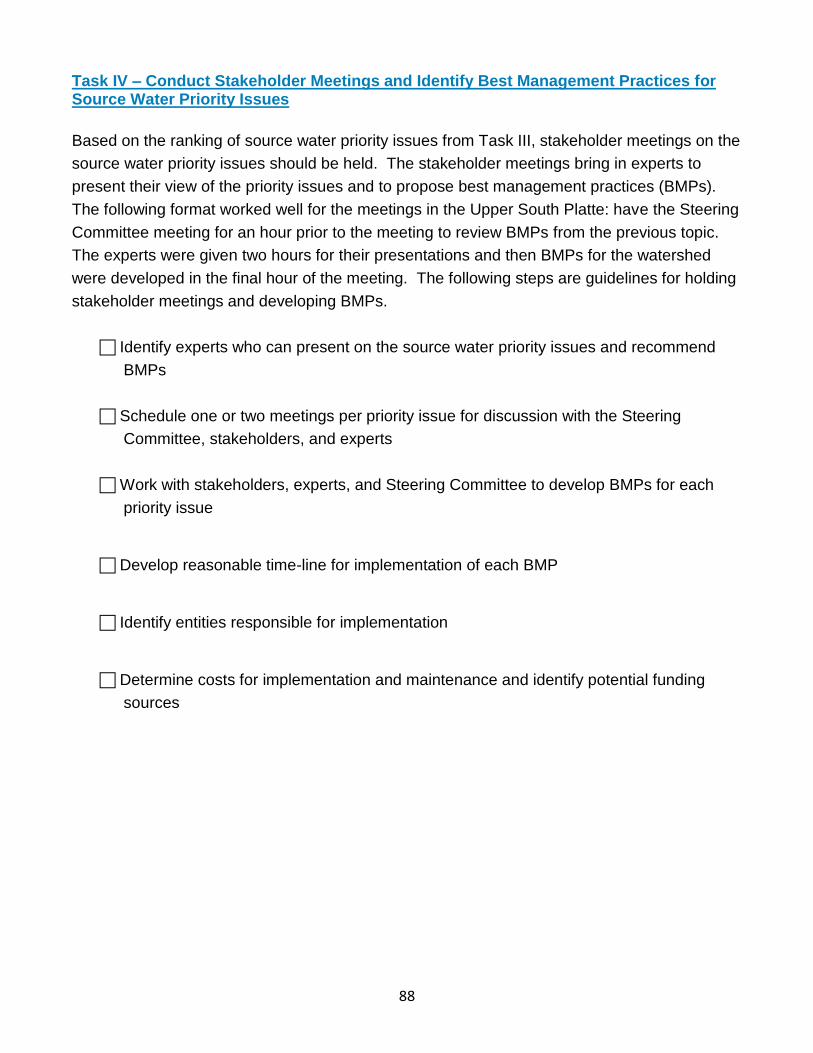
88
Task IV – Conduct Stakeholder Meetings and Identify Best Management Practices for Source Water Priority Issues
Based on the ranking of source water priority issues from Task III, stakeholder meetings on the
source water priority issues should be held. The stakeholder meetings bring in experts to
present their view of the priority issues and to propose best management practices (BMPs).
The following format worked well for the meetings in the Upper South Platte: have the Steering
Committee meeting for an hour prior to the meeting to review BMPs from the previous topic.
The experts were given two hours for their presentations and then BMPs for the watershed
were developed in the final hour of the meeting. The following steps are guidelines for holding
stakeholder meetings and developing BMPs.
Identify experts who can present on the source water priority issues and recommend
BMPs
Schedule one or two meetings per priority issue for discussion with the Steering
Committee, stakeholders, and experts
Work with stakeholders, experts, and Steering Committee to develop BMPs for each
priority issue
Develop reasonable time-line for implementation of each BMP
Identify entities responsible for implementation
Determine costs for implementation and maintenance and identify potential funding
sources
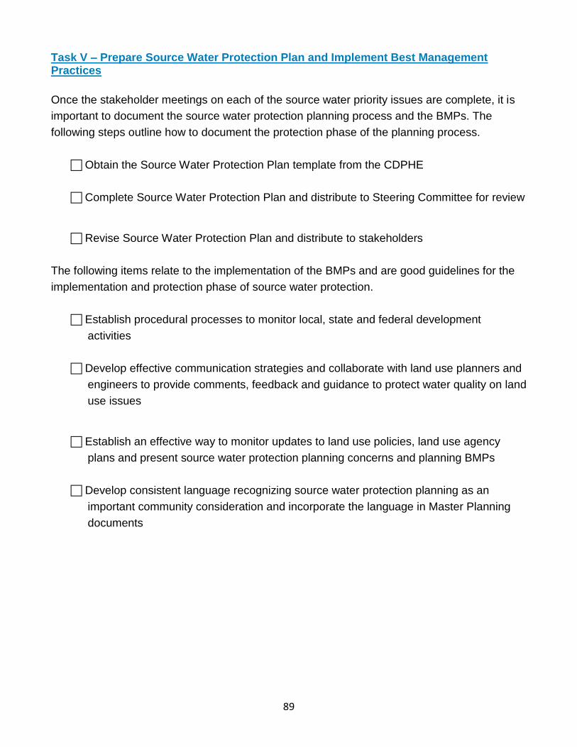
89
Task V – Prepare Source Water Protection Plan and Implement Best Management Practices
Once the stakeholder meetings on each of the source water priority issues are complete, it is
important to document the source water protection planning process and the BMPs. The
following steps outline how to document the protection phase of the planning process.
Obtain the Source Water Protection Plan template from the CDPHE
Complete Source Water Protection Plan and distribute to Steering Committee for review
Revise Source Water Protection Plan and distribute to stakeholders
The following items relate to the implementation of the BMPs and are good guidelines for the
implementation and protection phase of source water protection.
Establish procedural processes to monitor local, state and federal development
activities
Develop effective communication strategies and collaborate with land use planners and
engineers to provide comments, feedback and guidance to protect water quality on land
use issues
Establish an effective way to monitor updates to land use policies, land use agency
plans and present source water protection planning concerns and planning BMPs
Develop consistent language recognizing source water protection planning as an
important community consideration and incorporate the language in Master Planning
documents
90
SECTION TWO – BEST MANAGEMENT PRACTICES CHECKLISTS The Steering Committee and other stakeholders developed the following Best Management Practices (BMPs) during the source water protection planning process. The intent of the BMPs is to improve source water quality in the watershed. The Steering Committee recognizes that not all of the BMPs can be immediately implemented and that some of the BMPs will take a number of years. The following checklist should be used to assist Denver Water staff and others invested in source water protection in performing their water quality protection duties.
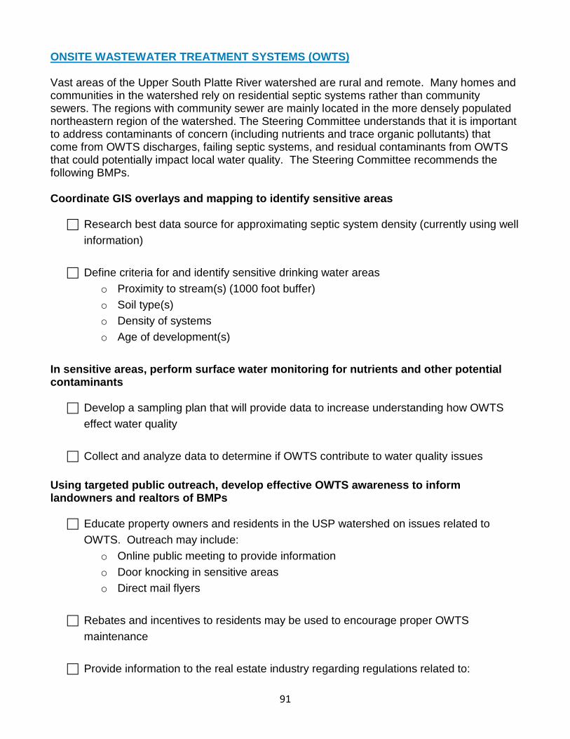
91
ONSITE WASTEWATER TREATMENT SYSTEMS (OWTS) Vast areas of the Upper South Platte River watershed are rural and remote. Many homes and communities in the watershed rely on residential septic systems rather than community sewers. The regions with community sewer are mainly located in the more densely populated northeastern region of the watershed. The Steering Committee understands that it is important to address contaminants of concern (including nutrients and trace organic pollutants) that come from OWTS discharges, failing septic systems, and residual contaminants from OWTS that could potentially impact local water quality. The Steering Committee recommends the following BMPs. Coordinate GIS overlays and mapping to identify sensitive areas
Research best data source for approximating septic system density (currently using well
information)
Define criteria for and identify sensitive drinking water areas
o Proximity to stream(s) (1000 foot buffer)
o Soil type(s)
o Density of systems
o Age of development(s)
In sensitive areas, perform surface water monitoring for nutrients and other potential contaminants
Develop a sampling plan that will provide data to increase understanding how OWTS
effect water quality
Collect and analyze data to determine if OWTS contribute to water quality issues
Using targeted public outreach, develop effective OWTS awareness to inform landowners and realtors of BMPs
Educate property owners and residents in the USP watershed on issues related to
OWTS. Outreach may include:
o Online public meeting to provide information
o Door knocking in sensitive areas
o Direct mail flyers
Rebates and incentives to residents may be used to encourage proper OWTS
maintenance
Provide information to the real estate industry regarding regulations related to:
92
o Transfer of Title requirements
o Inspections
o Pumping
o Repairs at time of sale
Review OWTS regulations and standards
Review the OWTS regulations for each county
Identify the county representative(s) that handle OWTS issues and establish a line of
communication for reviewing future developments that may impact water quality
Participate in next review of Regulation to ensure source water issues are addressed
Encourage OWTS inspections and record submittals on property transfers
Examine new County regulations for all four counties (adopted June 30, 2014)
regarding inspections at transfer of title
If not in effect, recommend that counties incorporate OWTS inspections at time of
transfer
93
AGRICULTURE PRACTICES Ranching is a vital part of the rich history of the Upper South Platte Watershed as well as a vibrant industry in the region today. From large-scale ranching operations to small hobby farms, ranching thrives in the western portions of the watershed. Strong and active associations and organizations help ranchers understand state-of–the-art ranching techniques and best management practices. Programs offered through the United States Department of Agriculture (USDA) Natural Resources Conservation Service (NRCS) also provide outstanding resources and funding opportunities for the ranching communities. There is still much to be done to ensure consistent BMPs that preserve and protect the resources impacted by agricultural activities. Identify sensitive drinking water areas adjacent to and downstream of agricultural operations
Gather GIS data indicating land use for agricultural purposes
Define sensitive drinking water areas
o Proximity to stream (1000 foot buffer)
o Soil type
o Density of operations
Coordinate with Colorado State University (CSU) Extension Services, NRCS, and
Conservation Districts to identify and protect priority areas
Draft standardized language and policies for grazing contracts between large landowners, land use managers and ranchers
Research example lease language (USDA, NRCS, Cattlemen’s Association, Colorado
State Extension)
Draft example contract containing sample language. Encourage use of
o Riparian buffers
o Hardened water crossings for livestock
o Off channel livestock watering
Distribute document to stakeholders and refine it as needed
Develop a stakeholder based approach to engage the entities in using the new template
Using targeted education tools, develop effective agricultural practices materials to inform landowners and real estate industry of BMPs
94
Identify/generate “Rural Realities/Lifestyle” resources e.g.
http://www.extension.colostate.edu/gilpin/natu/natu_docs/Mountain Livestock Brochure-
GilpinNew reviewed.pdf ; http://www.co.teller.co.us/communications/rural.htm
With input from partners, develop and distribute outreach materials
Identify and promote funding opportunities for landowners to improve agricultural practices
Create a list of funding sources for agricultural practices and BMP’s
Research ways to implement off-channel livestock watering practices
Determine best outreach organization and coordinate with them. Potential partners
include: NRCS, Colorado Cattleman’s association, USDA, USFS, BLM
Research the potential of funding for BMPs through conservation easements. Potential
partners include: Cattleman’s Land Trust, Palmer Land Trust, Mountain Area Trust,
Colorado Open Lands and Colorado Agricultural Leadership Foundation (CALF).
Research the availability of augmentation water or regulatory alternatives for off
channel livestock watering
95
OIL & GAS EXPLORATION Oil and gas resource exploration and extraction in Colorado have been taking place since the mid-twentieth century. The majority of active extraction currently occurs in the northern part of the state, but areas within the Upper South Platte watershed have been identified as viable sources for exploration. This is a complex and potentially controversial issue. Matters of surface land ownership versus mineral rights and the vast areas of land involved in drilling can further complicate the issue. It is important to understand the many ways in which water can be impacted ranging from the intensive use of water for resource extraction to the impacts on water quality caused by drilling and extraction operations, as well as reinjection or water disposal. The Colorado Oil and Gas Conservation Commission (COGCC), a division of the Colorado Department of Natural Resources is the agency that interfaces with the Colorado Oil and Gas Association (COGA) and the industry in regulatory and compliance issues. After presentations from COGCC and COGA, the Steering Committee recommended the following BMPs. Participate in the BLM Master Leasing Plan process and the Pike and San Isabel National Forests Oil and Gas Leasing process
Work with key agencies in BLM Master Leasing Plan process (Royal Gorge BLM, RMP,
Pike San Isabel Oil and Gas Leasing Plan)
o BLM (Statewide draft water stipulations for surface protection, NSO Municipal
wells, etc. – get copies)
o Park County (has regulations related to oil and gas development)
o Colorado Department of Public Health and Environment (CDPHE)
o COGA
o COGCC
o USFS
Provide GIS layers as requested
Attend planning meetings and provide comments relevant to source water protection
Determine and define setbacks around reservoirs, perennial streams, wells, diversion
points, and other sensitive areas
Work with other counties to raise awareness of BMPs for oil and gas development
Identify environmentally sensitive areas for all of Upper South Platte watershed
Contact local designee for each county, establish a relationship with them and inform
them of recommendation of BLM Master Leasing Program
96
Develop consistent language recognizing source water protection planning as an
important community consideration and include language in Memorandum of
Understanding with counties
Monitor oil and gas leasing on Denver Water properties
Check COGCC permit application information on a regular basis
Form working relationships with State Land Board personnel
Provide guidance on suggested BMPs to local designee for each county
97
TRANSPORTATION: Roads and Maintenance Multi-modal transportation corridors in the Upper South Platte Watershed range from social trails established over decades of recreational use to well-traveled State highways. The four State highways (285, 24, 67 and 9) that crisscross the watershed carry residents, commuters, tourists and commercial users throughout the watershed, and also connect them to major metropolitan and recreational destinations. The Steering Committee recommends the following BMPs related to roads and trails. Identify sensitive areas and sediment transport/deposition potential occurring in proximity to these areas
Review previous sediment impact assessments for sensitive area analysis
Form a committee of experts to discuss this issue and assess priority areas
Define criteria for sensitive areas (e.g., roads in close proximity to drinking water
infrastructure, hazardous material trucking routes, etc.)
Identify maintenance entities that work in sensitive areas and provide maps of sensitive areas
Identify who owns roads and maintains roads in the watershed. Likely parties include:
o USFS
o BLM
o Counties
o Private land owner and home owners associations
o USFS
o Colorado Department of Transportation (CDOT)
o Denver Water
Review county(s) BMPs – consolidate for road maintenance education at all levels
(including targeted subdivisions/private ownership)
o Integrate BMP training into existing annual organizational internal training events
o Attend appropriate staff meetings for educational purposes
Establish connections for weed spraying activities, share the sensitive areas near
streams with them
Coordinate with road owners and trade organizations that deal with grading roads to do coordinated outreach and training of operators
Identify existing projects that employ BMPs to use as project review sites for county
maintenance crews – possibly develop a video tour or workshops
98
Create “cheat sheet” with BMPs for road maintenance operators
In sensitive areas, consider signage for blade operators (e.g., tilt left here)
Consider presenting BMPs at APWA local annual conference
Provide road maintenance training for Denver Water operators
Review USFS Road Construction Best Management Practices and integrate where appropriate
99
TRANSPORTATION: Emergency Response and Hazardous Waste Effective emergency spill responses depend on excellent communication and quick actions by relatively few individuals, including emergency responders and water supply managers. Maintaining adequate water supply during floods, forest fires, windstorms, or manmade disasters is a matter of good planning to protect water supplies and power to operate treatment and supply facilities. Roads and highways can contaminate water sources through spills, dust, and road treatments including salts, sands, and other chemicals for snow and ice. Additionally, fuels, oils, and other contaminates carried by vehicles can be released slowly onto roads and highways. Rapid and coordinated response and communication during all phases of Emergency Response is critical for the health and safety of area residents and their water supply. Identify and raise awareness to sensitive areas and the potentially hazardous activities occurring in proximity
Form a committee of experts to discuss this issue and assess priority areas
Define criteria for sensitive areas (e.g., roads in close proximity to drinking water
infrastructure, hazardous material trucking routes, etc.)
Consider signage on the side of the road indicating that motorists are entering a
sensitive source water protection area
Outreach to emergency responders and dispatchers to help them understand the potential impacts of spills and hazardous waste to source water quality
Create and provide a laminated info card and dashboard stickers to emergency
responders with
o Colorado Spill Hotline Info: 1-877-518-5608
o Sensitive areas map
o Denver Water and other agency contact information
Distribute laminated card and dashboard stickers with hotline info to emergency
responders
Conduct a spill kit inventory and provide spill kits to emergency responders in sensitive areas
Do an inventory analysis of which emergency responders have spill kits and who is
trained to use to use them
100
Consider adding additional spill kits in emergency response vehicles – oil spill kits,
hazmat kits (for car accidents, etc.)
Provide kits to emergency responders who operate in sensitive areas and do not have
kits
Encourage development of hazardous waste disposal and recycling programs in watershed
Reach out to counties to see if they have existing programs
Research ways and funding opportunities to develop programs. Potential focus areas
should include:
o Prescription take back programs
o Electronics recycling
o Habitat for Humanity paint recycling
o Pesticide and herbicide disposal
Coordinate with counties and other stakeholders to develop and promote hazardous
waste disposal and recycling programs
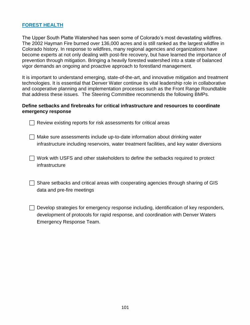
101
FOREST HEALTH
The Upper South Platte Watershed has seen some of Colorado’s most devastating wildfires. The 2002 Hayman Fire burned over 136,000 acres and is still ranked as the largest wildfire in Colorado history. In response to wildfires, many regional agencies and organizations have become experts at not only dealing with post-fire recovery, but have learned the importance of prevention through mitigation. Bringing a heavily forested watershed into a state of balanced vigor demands an ongoing and proactive approach to forestland management. It is important to understand emerging, state-of-the-art, and innovative mitigation and treatment technologies. It is essential that Denver Water continue its vital leadership role in collaborative and cooperative planning and implementation processes such as the Front Range Roundtable that address these issues. The Steering Committee recommends the following BMPs. Define setbacks and firebreaks for critical infrastructure and resources to coordinate emergency response
Review existing reports for risk assessments for critical areas
Make sure assessments include up-to-date information about drinking water
infrastructure including reservoirs, water treatment facilities, and key water diversions
Work with USFS and other stakeholders to define the setbacks required to protect
infrastructure
Share setbacks and critical areas with cooperating agencies through sharing of GIS
data and pre-fire meetings
Develop strategies for emergency response including, identification of key responders,
development of protocols for rapid response, and coordination with Denver Waters
Emergency Response Team.
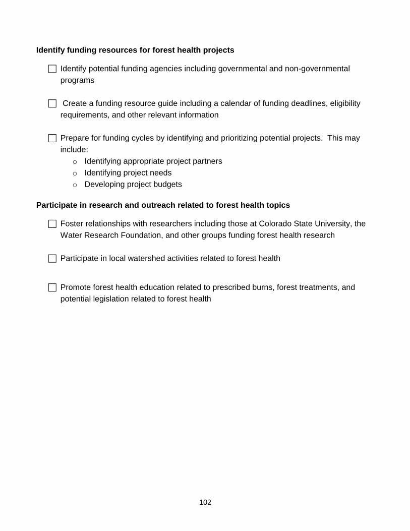
102
Identify funding resources for forest health projects
Identify potential funding agencies including governmental and non-governmental
programs
Create a funding resource guide including a calendar of funding deadlines, eligibility
requirements, and other relevant information
Prepare for funding cycles by identifying and prioritizing potential projects. This may
include:
o Identifying appropriate project partners
o Identifying project needs
o Developing project budgets
Participate in research and outreach related to forest health topics
Foster relationships with researchers including those at Colorado State University, the
Water Research Foundation, and other groups funding forest health research
Participate in local watershed activities related to forest health
Promote forest health education related to prescribed burns, forest treatments, and
potential legislation related to forest health
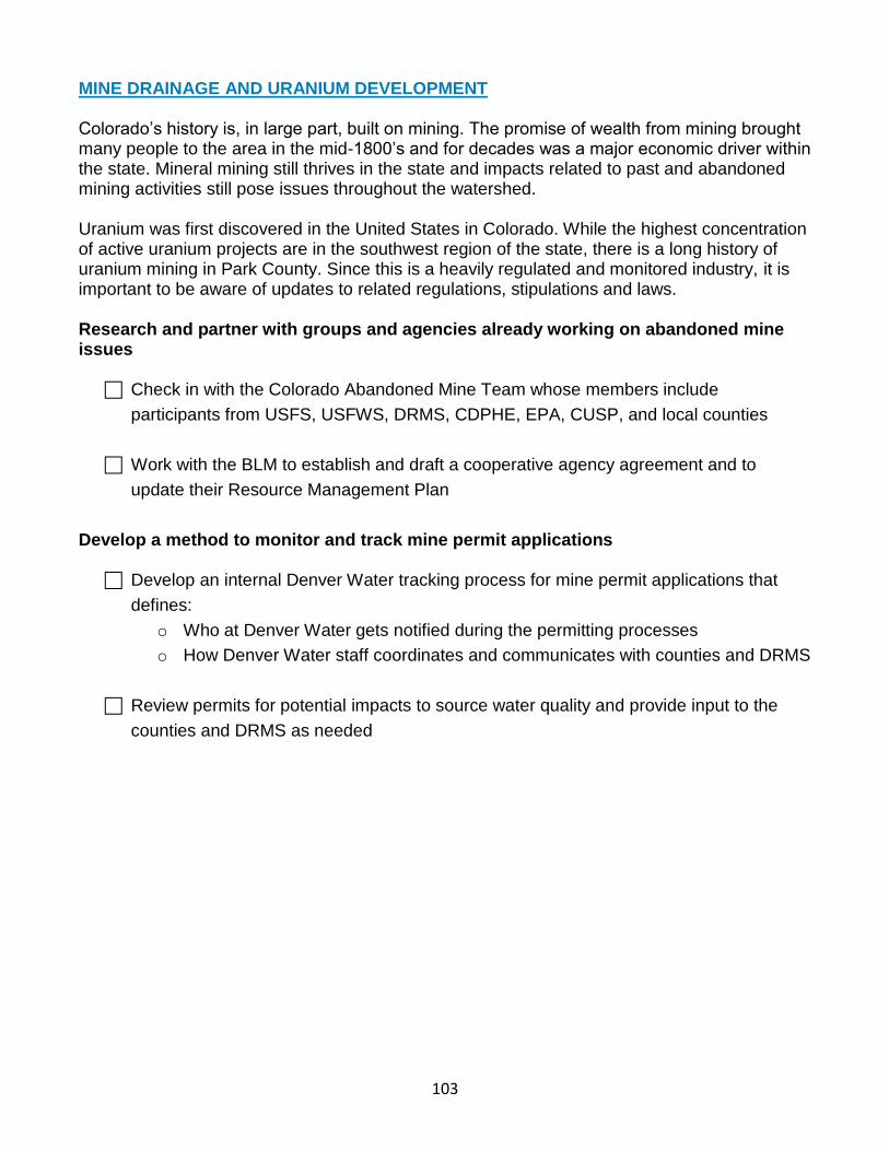
103
MINE DRAINAGE AND URANIUM DEVELOPMENT Colorado’s history is, in large part, built on mining. The promise of wealth from mining brought many people to the area in the mid-1800’s and for decades was a major economic driver within the state. Mineral mining still thrives in the state and impacts related to past and abandoned mining activities still pose issues throughout the watershed. Uranium was first discovered in the United States in Colorado. While the highest concentration of active uranium projects are in the southwest region of the state, there is a long history of uranium mining in Park County. Since this is a heavily regulated and monitored industry, it is important to be aware of updates to related regulations, stipulations and laws. Research and partner with groups and agencies already working on abandoned mine issues
Check in with the Colorado Abandoned Mine Team whose members include
participants from USFS, USFWS, DRMS, CDPHE, EPA, CUSP, and local counties
Work with the BLM to establish and draft a cooperative agency agreement and to
update their Resource Management Plan
Develop a method to monitor and track mine permit applications
Develop an internal Denver Water tracking process for mine permit applications that
defines:
o Who at Denver Water gets notified during the permitting processes
o How Denver Water staff coordinates and communicates with counties and DRMS
Review permits for potential impacts to source water quality and provide input to the
counties and DRMS as needed
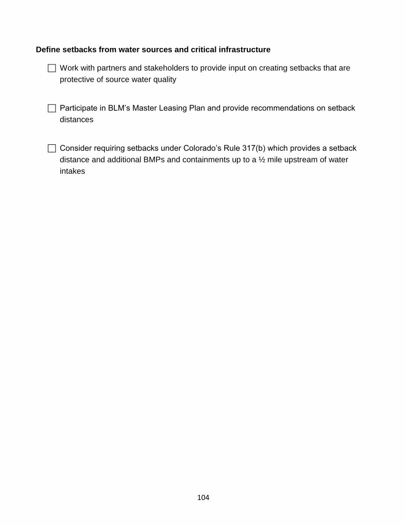
104
Define setbacks from water sources and critical infrastructure
Work with partners and stakeholders to provide input on creating setbacks that are
protective of source water quality
Participate in BLM’s Master Leasing Plan and provide recommendations on setback
distances
Consider requiring setbacks under Colorado’s Rule 317(b) which provides a setback
distance and additional BMPs and containments up to a ½ mile upstream of water
intakes
105
HYDRO-GEOMORPHIC ISSUES The hydro-geomorphology of the region is critical to understanding impacts on source water. Knowing the material makeup of the river bank, as well as its stability is important in preparing for and preventing river bank erosion. In addition, understanding the top- and sub-soil makeup aids in preparing for additional sediment transport to the river through both the saturated and unsaturated zones.
Identify and map existing Watershed Assessment of River Stability and Sediment
Supply (WARSSS) and similar type studies and reports within the watershed
Implement WARSS Rapid Assessments in areas with no data
Get involved and participate in Basin Implementation Plans and river basin roundtables
o How do they tie to WARSSS and other assessments
o What is the relationship between the water quantity and water quality
o Is funding available for assessments from the roundtables
Identify high priority projects
o Identify partners
o Identify funding sources as needed
106
MONITORING Monitoring the progress of the SWPP is vital to its overall success. Monitoring helps identify areas in which the plan has not been followed or is behind schedule and can bring the project back on task. In addition, it allows for critique of the plan and implementation of changes as issues inevitably arise.
Increase monitoring of source water priority constituents with special monitoring
projects
Identify areas in plan that would benefit from specific monitoring
o Existing/ongoing
o New monitoring projects
Attend DW fall monitoring meeting to discuss needs for the source water plan
o First go over the existing monitoring program/strategy to understand what DW is
currently doing
o Outline needs for out-of-house monitoring
o Get broader group together to define monitoring projects
Prioritize contaminants
Develop monitoring plan for source water; identify specific needs that would become
special projects with DW and/or outside partners
Cohesive monitoring plan – assess existing data and process; reevaluate the monitoring
strategy and modify to meet the needs of the source water plan
107
GIS/MAPPING GIS and mapping are the tools that tie the plan together. They provide the picture of where source water points exist in the watershed as well as the proximity of activity to those points. Effectively using GIS can be a complex process and requires cooperation from many stakeholders. Hosting the large amounts of information needed to create functional products is a challenge that requires identifying both needs and products as well as existing information and gaps in needed information. Create an online GIS tool to share information related to source water protection with stakeholders
Identify each plan area that requires GIS, layers and mapping components
Identify audience(s). This will inform what layers are needed
o Internal Denver Water use
o Small fire districts, water providers
o Public use
Based on the targeted audience, identify the type of functionality required
o ArcGIS
o Online tools
Identify applications/data/systems hosting options
o Secured/unsecured (data security criteria)
o Develop a list of what data is shared with stakeholders vs. public
Secured for identified stakeholders
Unsecured for public access
o ESRI
Data gaps analysis for required layers for the plan
o Identify what entities will have the information,
Counties
USFS
DW
BLM, etc.
Analyze value/benefits of more resource-intensive GIS tools
108
OUTREACH & EDUCATION
Effective outreach and education is critical to the planning process and ensuring that clear information and tools get to the entities and people who need them. Developing a structure and platform for information dissemination is vital to the plan implementation. Messaging must be cohesive, consistent and targeted. Create an outreach and education campaign to inform stakeholders about source water protection priority issues
Identify each plan area that requires outreach and education
o Determine the strategies that best fit each area
o Identify existing educational materials
Reach out to entitles that have good educational resources and inform
them of the SWPP and ask for their help in getting info regarding source
water out to their constituents
Use and link these materials before developing new material
o Determine new materials that need to be developed
Work with Denver Water’s Public Affairs department to integrate messaging related to
source water protection into Denver Water’s existing messaging program
Develop additional outreach and educational materials as needed. Be sure to consider
the following:
o Who is the audience?
o What do they need?
o How can the information be share effectively?
Enter into a Memorandum of Understanding regarding source water protection
Draft Memorandum of Understanding (MOU) with input from Steering Committee
Reach out to staff from the counties who have participated in the source water
protection planning effort to determine how to introduce the MOU to County
Commissioners
Present MOU to County Commissioners and sign MOU
109
INTERN
As part of the grant from CDPHE, a portion of the funds must be used for implementation of the BMPs. The Steering Committee decided that a good use of those funds would be to hire an intern to get started on some of the high priority BMPs. The Upper South Platte Watershed Source Water Intern will work on projects to protect the water quality of the Upper South Platte Watershed. The following steps outline the process for hiring the intern and the tasks the intern should work on. Hire a Source Water Intern to assist with the implementation of BMPs
Write job description for the internship
Submit a letter indicating intent to spend implementation funds to CDPHE on Source
Water Intern
Work with CUSP to hire intern
o Post job announcement
o Screen candidates
o Interview candidates
o Select intern
Work with interns to implement BMPs. Projects may include:
o Developing educational and reference materials for professionals and the public
on topics such as septic system best practices, agricultural management, road
maintenance, hazardous spills response, forest health, mining, and erosion
mitigation as they relate to protecting water quality
o Creating inventories of existing resources, such as spill kit availability for
hazardous spill response and funding sources for landowners to make water
quality improvements on their property
o Connecting residents in the Upper South Platte Watershed with existing
resources for protecting water quality in their area
o Coordinating with other organizations to develop or disseminate resources and
plan projects
o Attending conference call meetings with the larger source water protection team
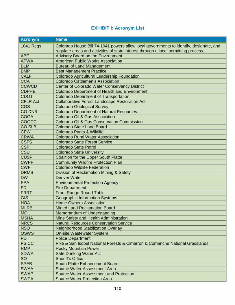
110
EXHIBIT I: Acronym List
Acronym Name
1041 Regs Colorado House Bill 74-1041 powers allow local governments to identify, designate, and regulate areas and activities of state interest through a local permitting process.
ABE Advisory Board on the Environment
APWA American Public Works Association
BLM Bureau of Land Management
BMP Best Management Practice
CALF Colorado Agricultural Leadership Foundation
CCA Colorado Cattlemen’s Association
CCWCD Center of Colorado Water Conservancy District
CDPHE Colorado Department of Health and Environment
CDOT Colorado Department of Transportation
CFLR Act Collaborative Forest Landscape Restoration Act
CGS Colorado Geological Survey
CO DNR Colorado Department of Natural Resources
COGA Colorado Oil & Gas Association
COGCC Colorado Oil & Gas Conservation Commission
CO SLB Colorado State Land Board
CPW Colorado Parks & Wildlife
CRWA Colorado Rural Water Association
CSFS Colorado State Forest Service
CSP Colorado State Patrol
CSU Colorado State University
CUSP Coalition for the Upper South Platte
CWPP Community Wildfire Protection Plan
CWF Colorado Wildlife Federation
DRMS Division of Reclamation Mining & Safety
DW Denver Water
EPA Environmental Protection Agency
FD Fire Department
FRRT Front Range Round Table
GIS Geographic Information Systems
HOA Home Owners Association
MLRB Mined Land Reclamation Board
MOU Memorandum of Understanding
MSHA Mine Safety and Health Administration
NRCS Natural Resources Conservation Service
NSO Neighborhood Stabilization Overlay
OSWS On-site Wastewater System
PD Police Department
PSICC Pike & San Isobel National Forests & Cimarron & Comanche National Grasslands
RMP Rocky Mountain Power
SDWA Safe Drinking Water Act
SO Sheriff’s Office
SPEB South Platte Enhancement Board
SWAA Source Water Assessment Area
SWAP Source Water Assessment and Protection
SWPA Source Water Protection Area
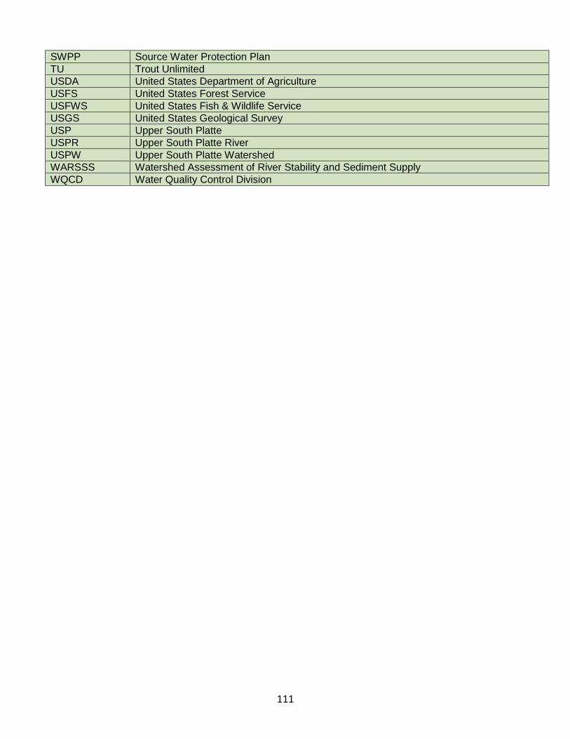
111
SWPP Source Water Protection Plan
TU Trout Unlimited
USDA United States Department of Agriculture
USFS United States Forest Service
USFWS United States Fish & Wildlife Service
USGS United States Geological Survey
USP Upper South Platte
USPR Upper South Platte River
USPW Upper South Platte Watershed
WARSSS Watershed Assessment of River Stability and Sediment Supply
WQCD Water Quality Control Division


![North Platte Tribune. (North Platte, NE) 1894-11-07 [p ]](https://img.pdfslide.net/doc/110x75/6194f7b6b7b4a03a236f33dd/north-platte-tribune-north-platte-ne-1894-11-07-p-.jpg)